Abstract
Based on monthly mean Argo profiler float data from 2004 to 2008 and monthly mean sea surface height and current velocity data from the Simple Ocean Data Assimilation (SODA) reanalysis for the period 1958–2007, the three-dimensional structure of the Mindanao Eddy (ME), its seasonal and interannual variability, and its impact on the thermohaline structure are analyzed. In addition, the displacement of the ME centre and its relation to ocean circulations are also discussed. The results showed that the ME spreads vertically from about 600 db depth upward to about 40 db depth. In addition to its strong seasonal variation, the strength of the ME displays strong interannual variability resulting from the interannual variability in the North Equatorial Current (NEC), the North Equatorial Counter Current (NECC) and the Mindanao Current (MC). The meridional movement of the centre of the ME has strong seasonal and interannual variability, and the zonal movement has a strong seasonal variation. The meridional movement is associated with the meridional displacement of the interface between the NECC and the NEC, whereas the zonal movement is associated with the zonal displacement of the interface between the MC and the northward branch of the NECC. The ME variability can greatly affect the pattern of the thermohaline structure in the local upper ocean. When the eddy is strong, the cold and low salinity water within it moves vigorously upward from the deep layer; the thermocline shoals significantly; the subsurface high salinity water shows a large decrease; and the upper mixed layer becomes thinner, and vice versa.
RÉSUMÉ [Traduit par la rédaction] En nous basant sur les données mensuelles moyennes des flotteurs profileurs Argo pour la période de 2004 à 2008 et sur les données mensuelles moyennes de hauteur de la surface de la mer et de vitesses vectorielles du courant fournies par les réanalyses SODA (Simple Ocean Data Assimilation) pour la période de 1958 à 2007, nous analysons la structure tridimensionnelle du remous de Mindanao, sa variabilité saisonnière et interannuelle et son impact sur la structure thermohaline. De plus, nous discutons du déplacement du centre du remous de Mindanao et de sa relation avec les circulations océaniques. Les résultats ont montré que le remous s'étend verticalement vers le haut à partir d'une profondeur de 600 db jusqu’à une profondeur d'environ 40 db. En plus de sa forte variabilité saisonnière, la force du remous de Mindanao affiche une forte variabilité interannuelle résultant de la variabilité interannuelle dans le courant nord-équatorial (NEC), le contre-courant nord-équatorial (NECC) et le courant de Mindanao (MC). Le mouvement méridien du centre du centre du remous de Mindanao affiche une forte variabilité saisonnière et interannuelle et le mouvement zonal possède une forte variabilité saisonnière. Le mouvement méridien est lié au déplacement méridien de l'interface entre le NECC et le NEC alors que le mouvement zonal est lié au déplacement zonal de l'interface entre le MC et le bras allant vers le nord du NECC. La variabilité du remous de Mindanao peut grandement modifier la configuration de la structure thermohaline dans les couches supérieures locales de l'océan. Quand le remous est fort, l'eau froide et de faible salinité qu'il renferme se déplace vigoureusement vers le haut à partir de la couche profonde; la thermocline s'élève de façon marquée; les eaux de subsurface de forte salinité affichent une diminution importante; et la couche de mélange supérieure devient plus mince, et inversement.
1 Introduction
The western equatorial Pacific Ocean, particularly the southernmost Philippine Sea, has attracted much attention from researchers because it plays a key role in the establishment of the El Niño-Southern Oscillation (ENSO) and may also be an important part of the so-called “great conveyor belt” caused by the Indonesian Throughflow (ITF). The Mindanao Eddy (ME) and the Halmahera Eddy (HE) and low latitude western boundary currents () are important aspects of these processes. Observations have shown that the North Equatorial Current (NEC) bifurcates at the western boundary along the Philippine coast into the northward flowing Kuroshio and the southward flowing Mindanao Current (MC) (Lukas et al., Citation1991; Qiu & Joyce, Citation1992; Qu, Mitsudera, & Yamagata, Citation1998; Toole, Millard, Wang, & Pu, Citation1990). The MC and the New Guinea Coastal Current (NGCC) flow equatorward, feeding the North Equatorial Counter Current (NECC). The ME and the HE straddle the NECC in the north (centred near 7°N, 128°E) and the south (centred near 4°N, 130°E), respectively (Wyrtki, Citation1961).
Fig. 1 Schematic diagram of the current pattern between Mindanao and New Guinea (adapted from Zhou et al., Citation2010 by permission of Science China Press). Solid lines denote surface-subsurface flow (i.e., the MC, the NECC, the NGCC, the ME, and the HE). The thin dashed lines indicate flow below the subsurface–intermediate layer (i.e., Mindanao Undercurrent (MUC) and New Guinea Coastal Undercurrent (NGCUC)). The NGCC in boreal summer is shown.
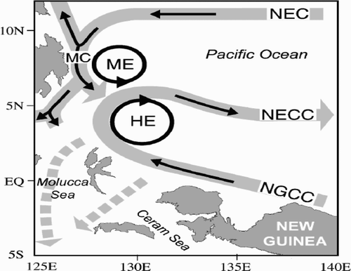
The ME is thought to be a cold water region characterized by a distorted elliptic form east of Mindanao Island related to the closed cyclonic circulation in the local sea area (Takahashi, Citation1959). This closed circulation is named the “Mindanao Eddy” following the work of Wyrtki (Citation1961) who argued that the ME is a quasi-permanent ocean phenomenon associated with the turning of the NEC water at the Philippines coast and its subsequent flow to the east part of the NECC. Afterwards, Masumoto and Yamagata (Citation1991) called the closed cyclonic circulation west of 160°E the Mindanao Dome (MD), which covers an area much larger than the ME. The two terms MD and ME are often confused because they are located in the same sea region (Udarbe-Walker & Villanoy, Citation2001). Because a complete knowledge of the structure and dynamics of the ME is necessary to understand the inflow of water from the Pacific Ocean into the Eastern Archipelago between Mindanao and New Guinea (Wyrtki, Citation1961), the ME has attracted much attention. Koenuma (Citation1937) first pointed out that the ME is centred at 7°N, 130°E, whereas Masuzawa (Citation1968) obtained the same result from the sea surface dynamic height relative to 1000 db. Using drifting float data, Lukas et al. (Citation1991) confirmed the existence of the ME and pointed out that its centre is located at 7°N, 128°E with a diameter of approximately 250 km. Based on historical data, Qu, Mitsudera, and Yamagata (Citation1999) suggested that the ME is centred at 7°N, 129°E based on the isopycnal depth distribution at the 24.5 σθ surface.
Some observations in the studies mentioned above indicate that the latitude of the centre of the ME is relatively stable (i.e., about 7°N) but other observations indicate that the longitude of the ME centre varies from 128°E to 130°E, which suggests a strong zonal displacement of the ME. In addition, Argo profile data show enhanced subsurface mesoscale eddy activity below the ME, in the 1000–2000 m layer (Zhou et al., Citation2006; Zhou, Yuan, Guo, Shi, & Zhang, Citation2010). Obviously, the detailed three-dimensional structure and variations of the ME and its subsurface eddies have remained unclear until now because of limited historical observations, especially subsurface observations in this region.
The dynamics of the variations of the ME, however, are still controversial. Based on historical hydrographic data in winter from 1965 to 1974, Guan (Citation1989) showed that the interannual variability of the spatial structure of the ME is associated with El Niño events. Using results from a high-resolution oceanic general circulation model (OGCM), Tozuka, Kagimoto, Masumoto, and Yamagata (Citation2002) examined the multiscale variations of the ME and found that its variation is governed by both variations of the locally forced Ekman upwelling and the remotely forced downwelling in the east. Arruda and Nof (Citation2003) argued, however, that the variability in the ME can be attributed to the interactions of the MC and the NGCC. Based on data from drifting floats, Acoustic Doppler Current Profilers (ADCPs) and Argo data, Gao and Yu (Citation2008) argued that the ME displayed a weaker seasonal variation because of the out-of-phase fluctuations of the NEC/MC and the NECC from winter–spring to summer–fall. Recently, Zhang, Zhou, and Liu (Citation2012) discussed the interannual variation of the strength of the winter ME using conductivity-temperature-depth (CTD) data along section 137°E from 1967 to 2003 provided by the Japan Agency for Marine-Earth Science and Technology (JAMSTEC) and suggested that the ME strengthens (weakens) and expands eastward (retreats westward) in the winter of the year that an El Niño (La Niña) starts. Because this section is located at the eastern edge of the ME, the information on the section cannot fully represent the characteristics of the ME. Thus, it is necessary to use high spatial resolution data to further examine the ME.
Previous studies have provided the characteristics of the structure and seasonal variability of the ME at the surface. As mentioned above, because of the absence of long-term high spatial resolution observations, especially subsurface observations, the three-dimensional structure of the ME and its impact on the thermohaline structure are still unclear. Since the Argo project has been in operation, more data than ever before are available, providing an opportunity to investigate the detailed three-dimensional structure and seasonal and interannual variability of the ME further. The cause for displacement of the ME centre, and its impact on thermohaline structure are also discussed in order to understand better the thermohaline structure pattern variability in the upper northwestern Pacific Ocean.
2 Data and methodology
a Data Description
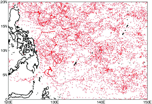
The monthly averaged temperature and salinity data used in this study are from Argo profile data provided by the Scripps Institute of Oceanography, USA, from 2004 to 2008. The data are available on a 1°latitude × 1°longtitude grid on 58 pressure levels spanning 2.5–1975 db, with separate levels 10 to 20 db apart above the 500 db level and 50–100 db apart below the 500 db level (Roemmich & Gilson, Citation2009). Note that the temperature and salinity profile data in the tropical northwestern Pacific Ocean (0°–20°N, 120°–150°E) () are used in this study.
Fig. 2 Spatial distribution of Argo floats during the 2004–08 period. (There are a total of 826550 T-S profiles.).
The sea surface height and zonal and meridional current velocity data were obtained from the international Research Institute for Climate and Society, Carton-Giese Simple Ocean Data Assimilation (SODA) reanalysis, version 2.0.2-4, with a resolution of 0.5°. The data cover the period 1958–2007. The SODA reanalysis is based on optional interpolation and is described by Carton and Giese (Citation2008). The ocean model has a horizontal resolution of 0.4° longitude × 0.25° latitude and has 40 vertical levels. Version 2.0.2-4 assimilates all available data from hydrographic stations from the World Ocean Database 2001 and the National Oceanographic Data Center/National Oceanic and Atmospheric Administration's (NODC/NOAA) temperature archive, including observations from the Tropical Atmosphere Ocean/Triangle Trans-Ocean Buoy Network (TAO/TRITON) mooring thermistor array and Argo drifters, as well as nearly continuous sea level information available from a succession of satellite-based altimeters and expendable bathythermographs (XBTs).
b Methodology
A dynamic computation method is adopted to calculate the sea surface dynamic height and geostrophic current velocity in this study. In addition, maximum entropy spectral and power spectral analysis methods are used to estimate the major variability periods for the sea surface dynamic height and sea surface height in the ME area.
3 Major properties of the ME and its seasonal and interannual variability
a Major Properties
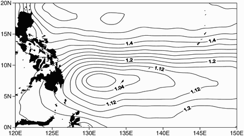
shows the annual mean dynamic height (DH) distribution at 2.5 db relative to 1975 db in the tropical northwestern Pacific Ocean from 2004 to 2008. The ME has a distorted elliptical shape with its centre located at 7.5°N, 132°E, which differs from earlier studies (Koenuma, Citation1937; Lukas et al., Citation1991; Masuzawa, Citation1968; Qu et al., Citation1999). Taking the 1.04 m line as its boundary, the ME has a meridional diameter of about 300 km and a zonal diameter of about 850 km.
Fig. 3 Annual mean DH distribution at 2.5 db relative to 1975 db in the tropical northwestern Pacific (units are metres).
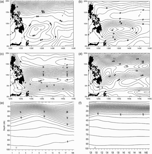
Because the ME is characterized by upwelling cold water, the temperature distribution is a good index for examining its horizontal and vertical structure. As shown in Figs 4a to 4d, the ME can be seen clearly from 40 db to 600 db. At 40 db depth, the temperature at the centre of the eddy is about 28.5°C, 0.3°C lower than that of the surrounding sea water (a) and drops to 6.4°C at 600 db depth, 0.4°C lower than that of the surrounding sea water (d). It is worth noting that the temperature is about 22°C at 100 db depth, 4°C lower than that of the surrounding sea water (b) and drops to 12.5°C at 200 db depth, more than 3°C lower than that of the surrounding sea water (c). The vertical structure of the ME can also be observed in the temperature distributions along section 132°E (e) and section 7.5°N (f). As shown in e and 4f, the ME centre moves northwestward with increasing depth, from 7.5°N, 132°E at 100 db to 11°N, 129°E at 600 db. In other words, the ME tilts southeastward from 600 db to the upper layer. Note that the temperatures at the centre of the eddy at 650 db and 700 db are 6.1°C and 5.8°C, respectively, 0.1°C lower than those of the surrounding sea water (not shown). Thus, we can conclude that the ME extends from about 600 db depth upward to about 40 db depth and is strongest at 100 db depth. Based on climatological current velocity data, Gao and Yu (Citation2008) pointed out that the ME weakens at around 450 m depth and disappears, whereas using Argo data from May 2007, Zhang et al. (Citation2012) found that the vertical range of the ME is between 50 m and 500 m; this differs somewhat from our results.
Fig. 4 Annual mean temperature distribution at different depths and sections (a) at 40 db depth, (b) at 100 db depth, (c) at 200 db depth, (d) at 600 db depth, (e) along section 132°E, and (f) along section 7.5°N.
It is worth noting that the vertical structure of salinity in the ME is a little complicated. The salinity is slightly higher (34.6–34.8 (practical salinity scale used)) between 100 db and 200 db depth but decreases to 34.5 at around 220 db depth (not shown). Guan (Citation1989) pointed out that North Pacific Intermediate Water (NPIW), characterized by minimum salinity (about 34.5), flows into the Celebes Sea with the MC and spreads between 200 m and 300 m depth to east of Mindanao Island and north of 4°–5°N, respectively. In fact, after entering the western ocean, the NPIW flows southward as far as the southern tip of Mindanao along the western boundary (Qu et al., Citation1999).
b Seasonal Variation
shows the multi-year averaged DH distribution at 2.5 db relative to 1975 db in the tropical northwestern Pacific Ocean in winter (January), spring (April), summer (July) and fall (October). Using the 1.04 DH line as the boundary, it can be seen that the horizontal scale of the ME has a strong seasonal variation (a to 5d). The horizontal scale is largest in winter with a meridional and zonal diameter of 700 km and 1980 km, respectively (a) and is smallest in fall with a meridional and zonal diameter of 120 km and 150 km, respectively (d).
Fig. 5 Seasonal variation in multi-year monthly averaged DH distribution at 2.5 db relative to 1975 db in (a) winter, (b) spring, (c) summer, and (d) fall.
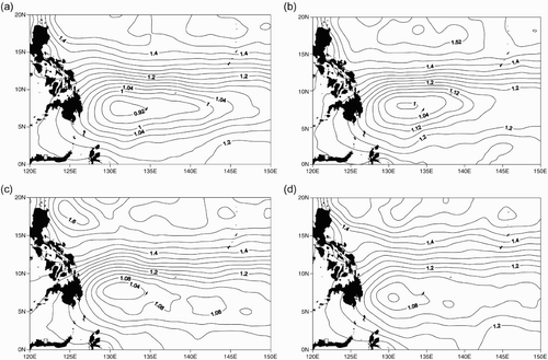
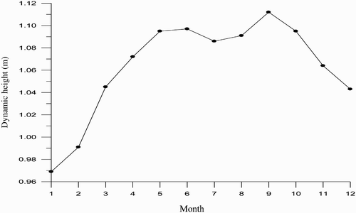
In order to understand the seasonal variation in the strength of the ME better, shows the climatological monthly averaged DH at 2.5 db relative to 1975 db in the ME region (5°–10°N, 125°–140°E). The DH is lowest in winter (January) and highest in fall (September). This indicates that the ME is characterized by being strongest in winter and weakest in fall. The seasonal variation of the strength of the ME may be caused by the interaction between the local seasonal cycle and the basin-scale seasonal cycle (Tozuka et al., Citation2002).
Fig. 6 Seasonal variation in the mean DH distribution at 2.5 db relative to 1975 db in the ME region.
c Interannual Variability
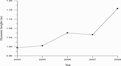
shows the year-to-year variation of the annual averaged DH at 2.5 db surface to 1975 db in the ME region. The DH is lowest in 2004 at 0.99 m and highest in 2008 at 1.17 m. In terms of the annual average strength, the ME is strongest in 2004 and weakest in 2008. In fact, the ME is strongest in January 2005 at 0.92 m and weakest in June 2008 at 1.21 m (not shown).
Fig. 7 Interannual variability in the mean DH at 2.5 db relative to 1975 db in the ME region.
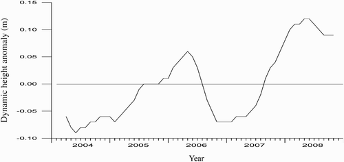
shows the interannual variability in mean DH anomaly (DHA) in the ME region after using a 5-month running mean filter. The DHA exhibits two peaks and two valleys between 2004 and 2008. The two peaks occur in April 2006 (0.06 m) and May 2008 (1.20 m), respectively, while the valleys appear in May 2004 (−0.09 m) and December 2006 (−0.07 m), respectively. This indicates that the ME has a strong quasi-biennial oscillation (QBO). The maximum entropy spectral analysis shows that the spectral value of the time series without using the filtering process is biggest near the 26-month period. In other words, the ME has a strong QBO.
Fig. 8 Interannual variability in the mean DH anomaly at 2.5 db relative to 1975 db in the ME region.
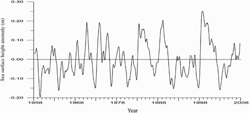
To understand the interannual variability of the strength of the ME better, we derive a time series of sea surface height anomalies (SSHAs) in the ME region (6°–9°N, 128°–133°E) based on the SODA monthly averaged sea surface height from 1958 to 2007. As shown in , the SSHA exhibits striking interannual variability closely associated with ENSO. The negative SSHA values (<−0.10 m) all appear during El Niño events except for 1959, whereas the positive values (>0.15 m) all occur during La Niña events. A power spectral analysis shows that the leading periods of the SSHA are 5.3 years and quasi-biennial, similar to those of ENSO.
Fig. 9 Interannual variation in SSHA in the ME region.
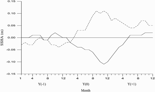
In order to examine the evolution of the strength of the ME during ENSO, we conduct a composite analysis of the SSHA in the ME region during 13 El Niño events (1963, 1965, 1968, 1972, 1976, 1979, 1982, 1986, 1991, 1993, 1994, 1997 and 2002) and 9 La Niña events (1964, 1967, 1970, 1973, 1974, 1984, 1988, 1995 and 1999) occurring since 1958. An event processed using composite analysis is termed a composite event, hereinafter, and the year when the El Niño (La Niña) starts is set to Y(0); the years before and after the El Niño (La Niña) year are Y(−1) and Y(+1), respectively. The composite results are shown in . The SSHA has a small positive value in the year before a composite El Niño event occurs but becomes negative at the beginning of the event year (January) and reaches a minimum in November then becomes positive in June of the following year. On the other hand, the SSHA has a small negative value in the year before a composite La Niña event occurs but becomes positive at the beginning of the event year (March) and reaches a maximum in September and a minimum in June of the following year.
Fig. 10 Composite of the sea surface height anomaly in the ME region. The solid line indicates the composite El Niño event; the dashed line indicates the composite La Niña event.
In short, the strength of the ME exhibits striking interannual variability closely related to ENSO. That is, during an El Niño (La Niña) event, the sea surface height (SSH) or the DH in the ME region all decrease (increase), meaning that the ME strengthens (weakens), which is consistent with previous studies (Guan, Citation1989; Tozuka et al., Citation2002).
Tozuka et al. (Citation2002) suggested that the interannual variation of the strength of the ME is governed by variations in both the Ekman upwelling forced locally and the downwelling forced remotely in the eastern Pacific Ocean. Because the ME is located near the NEC, the MC and the NECC, we should, therefore, examine the impacts of the NEC, MC, and NECC on the ME on an interannual time scale to find the possible cause of the interannual variability of the ME. The volume transports of the NEC, MC and NECC are all calculated using an integral method based on the monthly average current velocity values from the SODA data. The process for computing the volume transports is explained in the following.
The volume transports derived by integrating westward flowing velocities in the upper 500 m between 8°N and 20°N along section 130°E represent the NEC transport, while the volume transports derived by integrating eastward flowing velocities in the upper 500 m between 1°N and 8°N represent the NECC transport. The MC volume transport is obtained by integrating the southward flowing velocities in the upper 750 m between Mindanao Island and 130°E along section 8°N.
The calculations show that the climatological annual transports for the NEC, the NECC, and the MC are −48.5 Sv, 39.3 Sv, and −18.9 Sv (1 Sv = 106 m3 s−1), respectively, similar to those of previous studies (Chu, Li, & Fan, Citation2003; Johnson & McPhaden, Citation1999; Lukas et al., Citation1991; Qu et al., Citation1998; Wang, Zhang, Hu, & Seidel, Citation2001).
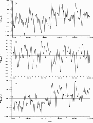
shows the interannual variability in the NEC, the NECC and the MC transport anomalies. The NEC transport displays strong interannual variability with leading periods of 5 years and quasi-biennial (a). Similar to the NEC, the NECC also exhibits strong interannal variability in its transport anomaly (b) and has leading periods of 1 year, quasi-biennial and 3.2 years. As shown in c, the MC has a lower interannual amplitude because the maximum (minimum) transport anomaly is approximately 10 Sv (−9 Sv) in 1999 (1964). However, the interannual variability trends are similar to those of the NEC and the NECC with leading periods of 5, 0.5 and 2.9 years. The cross-correlation analysis indicates that there are close correlations between SSHAs in the ME area and the NEC, NECC and MC transport with a peak coefficient of 0.48, −0.63 and 0.49, respectively, at the zero lag, significant at the 99% confidence level. This indicates that the interannual variability of the strength of the ME may be caused by the interannual variability of the NEC, NECC and MC. When these currents are all strong, the ME draws much kinetic energy from them and strengthens, and vice versa.
Fig. 11 Interannual variability in the (a) NEC, (b) NECC, and (c) MC volume transport anomalies (VTA).
4 Displacement of the ME centre and the ocean circulations
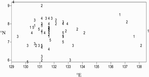
The displacement of the ME centre is currently unclear because of sparse data. Therefore, we analyzed the displacement of the ME centre statistically based on the monthly mean DH distribution at 2.5 db surface relative to 1975 db from 2004 to 2008. As shown in , the centre of the ME displays strong meridional and zonal movements. In the zonal direction, the centres are located on the west side (between 129° and 134°E) most of the time except for some individual months (e.g., April–June 2004 and March and November 2005) when it is located on the east side (east of 136.5°E). In the meridional direction, the centre's location varies between 6.5°N and 8.5°N in most months, occasionally shifting further north (9°–9.2°N) or south (5.9°–6.2°N) in some months.
Fig. 12 Scatter diagram for the ME centre from 2004 to 2008: 1 indicates 2004, 2 indicates 2005, 3 indicates 2006, 4 indicates 2007, and 5 indicates 2008.
To understand the year-to-year displacements of the ME centre better, we show the latitudinal () and longitudinal anomalies () of the ME centre after processing with a 5-month running mean filter. As shown in , the latitudinal anomaly has a strong interannual variation. Except for weak anomalies occurring from January 2004 to July 2005, the strong interannual variations occur after August 2005, with two peaks in December 2005 and July 2007, respectively, and two valleys in October 2006 and May 2008, respectively. It is worth noting that the ME centres move abnormally northward during the La Niña of 2007 (the Niño3 index shows that the event began in May 2007 and ended in March 2008), whereas they are centred in the southern region before the event. The results of the maximum entropy spectral analysis also shows that there are quasi-biennial and quasi-annual oscillations (according to the spectral value) in the meridional displacement of the ME centre. Thus, it can be seen that the ME centre has strong meridional movements at both seasonal and interannual time scales.
Fig. 13 Interannual variations in the latitudinal anomaly of the ME centre (solid line) and the interface between the NEC and the NECC (dashed line) along section 132°E.
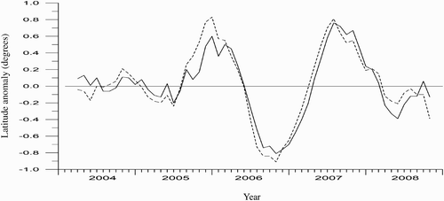
Fig. 14 Interannual variation in the longitudinal anomaly of the ME centre (solid line) and the interface between MC and the northward branch of the NECC (dashed line) along section 7.5°N.
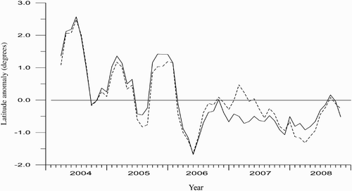
The longitudinal anomaly of the ME centre exhibits a significant variation (), but the trend is obviously different from that of the latitudinal anomaly. Prior to early 2006, the longitudinal anomalies are larger and basically positive (i.e., the ME centres move eastward), whereas after early 2006, the longitudinal anomalies are relatively smaller and basically negative (i.e., the centres move westward). Especially during the La Niña of 2007, the ME centres were all located in the western part. The maximum entropy spectral analysis shows that the major periods of the longitudinal anomaly are 8.8 months and 4.7 months, respectively. This indicates that the ME centre has an obvious zonal movement on a seasonal scale.
In summary, the ME centre displays strong meridional and zonal movement during 2004 and 2008, but it moves mostly northwestward during the La Niña of 2007. The cause for this movement, however, is unclear. This issue will now be discussed further.
The above analysis suggests that the interannual variability of the strength of the ME is associated with the interannual variability of the NECC, NEC and MC. Therefore, analyzing the relationship between these three currents and the ME centre will be helpful in understanding the cause for the displacement of the ME centre.
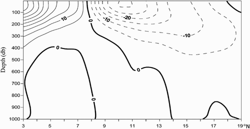
Because the ME is centred at 7.5°N, 132°E, we show the annual mean geostrophic current velocity distribution along section 132°E. As shown in , the NEC (dashed lines) is located north of approximately 7.6°N, while the NECC (solid lines) is located south of the section, quite similar to the results of Qu and Lukas (Citation2003) along section 130°E. Obviously, the interface (the zero current velocity line) of the two currents is located around 7.6°N at the sea surface, then gradually moves northward at increasing depths. In other words, the interface between the two currents is very close to the ME centre near 7.5°N. It seems to indicate that the meridional movement of the ME centre may be related to that of the interface between the two currents. shows the latitudinal anomaly of the interface between the NEC and the NECC from 2004 to 2008 (dashed line). The interannual variation in the interface latitudinal anomaly is consistent with that of the ME centre latitudinal anomaly. That is, when the interface moves northward, the ME centre also shifts northward, and vice versa. The maximum entropy spectral analysis indicates that the variation periods of the interface latitude anomaly are quasi-biennial and quasi-annual, similar to those of the ME centre. The correlation analysis shows that the correlation coefficient between them is 0.91 at the zero lag, significant at the 99% confidence level. In other words, the meridional displacements of the ME centre may be primarily caused by the meridional movements of both the NEC and the NECC.
Fig. 15 Annual mean geostrophic current velocity along section 132°E (units are cm s−1; the zero velocity surface is at 1000 db).
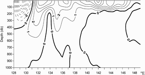
Tozuka et al. (Citation2002) and Chu et al. (Citation2003) pointed out that part of the NECC flows from south to north (the NECC northward branch) and feeds into the NEC on the eastern side of the ME. shows the annual mean geostrophic current velocity distribution along section 7.5°N. The MC (dashed lines) is located approximately west of 131°E, while the NECC northward branch (solid lines) is located between 131°E and 135°E. Obviously, the interface (the zero geostrophic current velocity line) between these two currents is located near 131°E at the sea surface then gradually moves westward with increasing depth, indicating that the multi-year averaged longitude of the interface between these two currents is closer to that of the ME centre. This means that the zonal displacement of the ME centre may be related to the zonal movement of both the MC and the northward branch of the NECC. shows the interannual variability in the longitudinal anomaly of the interface between the MC and the NECC northward branch from 2004 to 2008 (dashed line). The variation trend is consistent with that of the longitudinal anomaly of the ME centre. When the interface moves eastward, the ME centre will also move eastward and vice versa. From the maximum entropy spectral analysis, the leading periods of the interface of the longitudinal anomaly are 8.7 months and 4.6 months, similar to those of the longitudinal anomaly of the ME centre. The correlation analysis shows that the correlation coefficient between them is 0.95 at the zero lag, significant at the 99% confidence level. That is, the zonal displacement of the ME centre may be primarily caused by that of the MC and the northward branch of the NECC.
Fig. 16 Annual mean geostrophic current velocity distribution along section 7.5°N (units are cm s−1; the zero velocity surface is at 1000 db).
5 Impact of the ME on thermohaline structures
Zhang et al. (Citation2012) analyzed the impact of the ME on the thermohaline structure in the local sea region based on temperature and salinity data along section 137°E during the winter of 1998 and 2000 and suggested that the ME has a strong impact on the local thermohaline structure. Because the section is far from the ME centre, located at 7.5°N, 132°E; however, the impact of the ME on the thermohaline structure cannot be fully determined using only the data from that location. Thus, it is necessary to use Argo profile data which has a relatively high resolution to discuss this issue further. From the above analysis we know that the ME is strongest in January 2005 and weakest in June 2008. Therefore, we will discuss the impact of the ME on the thermohaline structures during those particular two months.
shows the distributions of the temperature and salinity along section 132°E in January 2005. The shoaling of isotherm contours from 500 db depth near 7.5°N produces a strong thermocline between 50 and 200 db. Thus, the 20°C isothermal line rises to about 100 db depth, and the thickness of the upper mixed layer becomes obviously thinner, at only about 50 db (a).
Fig. 17 Distribution of (a) temperature and (b) salinity along section 132°E in January 2005.
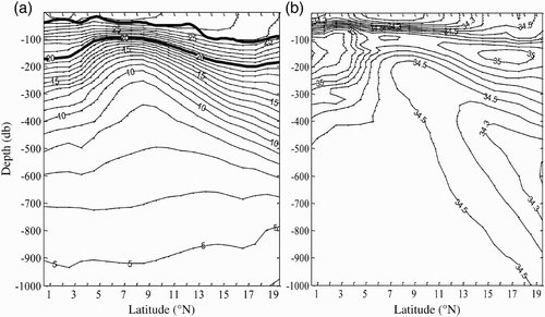
The salinity distribution (b) in January 2005 is significantly different from the temperature distribution. The salinity is lower above 50 db between the equator and 15°N (S < 34.4) but higher below 300 db. High salinity regions south of 7°N (S > 35.3) and north of 9°N (S > 35.0) are the front edges of the South and North Pacific subtropical high salinity water, respectively, while NPIW (S < 34.3) upwells as it flows southward, and its edge (34.5 isohaline) reaches almost 200 db near 7°N, thinning the upper high salinity water (S > 34.7) (only 50 db thick), thus preventing the North Pacific subtropical high salinity water from spreading southward.
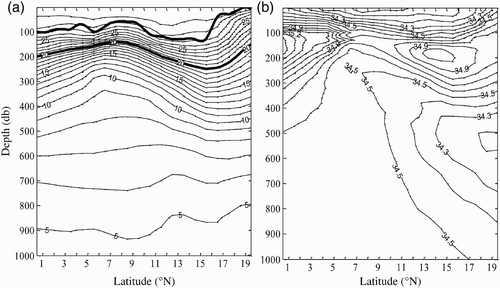
The temperature and salinity structures along section 132°E in June 2008, when the ME is weak, are shown in . The upwelling of the isotherm lines near 7.5°N is obviously weaker and the 20°C isotherm line is located near 150 db. Thus, the upper mixed layer becomes obviously thicker with a thickness of about 100 db (a). Meanwhile, the low salinity water (S < 34.5) becomes thicker (about 100 db) between 5°N and 10°N, while the thickness of the high salinity water (S > 34.6) also thickens to about 80 db (b). The southward flowing and upwelling of the intermediate layer low salinity water of the North Pacific becomes weaker, and its edge only reaches 270 db near 8°N, aiding the southward spread of the subtropical high salinity water (S > 34.9) in the North Pacific.
Fig. 18 Distribution of (a) temperature and (b) salinity along section 132°E in June 2008.
As mentioned above, the ME greatly affects the local thermohaline structure. When the eddy is strong, the cold and low salinity water within it moves vigorously upward from the deep layer, the thermocline shoals significantly, and the upper mixed layer becomes thinner and vice versa. So, the 20°C isotherm line rises to about 50 db during the period when the ME is strong (e.g., January 2005) which is higher than when it is weak (e.g., June 2008).
6 Conclusions
| • | The ME is located in the region 6°–9°N, 127°–138°E. Its annual mean meridional and zonal diameters are 300 km and 850 km, respectively. The vertical extent of the eddy is between 40 and 600 db. The eddy is characterized by being strongest in winter and weakest in fall. The ME strength has striking interannual variability associated with ENSO events, whereas this interannual variability may be caused by the interannual variability of the NEC, the NECC and the MC. | ||||
| • | The ME also has strong seasonal and interannual variability in the meridional movement of its central position but only strong seasonal variability in its zonal movement. This movement is mainly related to the variation of the surrounding currents. The meridional movement may be associated with the meridional displacement of the interface between the NECC and the NEC, while the zonal movement may be associated with the zonal displacement of the interface between the MC and the northward branch of the NECC. | ||||
| • | The ME has a large effect on the local thermohaline structure. When the eddy is strong, the cold and low salinity water within the eddy moves vigorously upward from the deep layer, the thermocline shoals significantly, the thickness of the high salinity water and the upper mixed layer both become thinner and vice versa. So, the 20°C isotherm line rises to about 50 db during the period when the ME is strong, which is higher than when it is weak. | ||||
Acknowledgements
This work was supported by the National Basic Research Program of China 973 project (contract number: 2007CB816002, 2012CB417402), the innovative key project of the Chinese Academy of Sciences (KZCXZ-YW-201) and the Fund of the Key Laboratory of Global Change and Marine-Atmospheric Chemistry, SOA (GCMAC2010).
Related Research Data
References
- Arruda , W. and Nof , D. 2003 . The Mindanao and Halmahera eddies—twin eddies induced by nonlinearities . Journal of Physical Oceanography , 33 : 2815 – 2830 . (doi:10.1175/1520-0485(2003)033<2815:TMAHEE>2.0.CO;2)
- Carton , J. A. and Giese , B. S. 2008 . A reanalysis of ocean climate using simple ocean data assimilation (SODA) . Monthly Weather Review , 136 ( 8 ) : 2999 – 3017 . (doi:10.1175/2007MWR1978.1)
- Chu , P. C. , Li , R. F. and Fan , C. W. 2003 . Determination of the current system on isopycnal surface between Mindanao and New Guinea from GDEM . Chinese Journal of Oceanology and Limnology , 21 ( 3 ) : 193 – 213 . (doi:10.1007/BF02842836)
- Gao , L. D. and Yu , W. D. 2008 . Observations and analysis on seasonal variation of western boundary currents and eddy structures in the western Pacific Ocean of the low latitudes . Advances in Marine Science , 26 ( 3 ) : 317 – 325 . (in Chinese with English abstract)
- Guan , B. X. 1989 . Variation of the Mindanao Eddy and its relation to El Niño . Oceanologia et Limnologia Sinica , 20 ( 2 ) : 131 – 137 . (in Chinese with English abstract)
- Johnson , G. C. and McPhaden , M. J. 1999 . Interior pycnocline flow from the subtropical to the equatorial Pacific Ocean . Journal of Physical Oceanography , 29 : 3071 – 3089 . (doi:10.1175/1520-0485(1999)029<3073:IPFFTS>2.0.CO;2)
- Koenuma , K. 1937 . On the hydrography of the southwestern part of the North Pacific and the Kuroshio. Part I: General oceanographic features of the region . The Imperial Marine Observatory Kobe, Japan , 6 ( 1 ) : 279 – 332 .
- Lukas , R. , Firing , E. , Hacker , P. , Richardson , P. L. , Collins , C. A. , Fine , R. and Gammon , R. 1991 . Observations of the Mindanao Current during the Western Equatorial Pacific Ocean circulation study . Journal of Geophysical Research , 96 : 7089 – 7104 . (doi:10.1029/91JC00062)
- Masumoto , Y. and Yamagata , T. 1991 . On the origin of a mode ENSO in the western Pacific . Journal of the Meteorological Society of Japan , 69 : 197 – 207 .
- Masuzawa , J. 1968 . Second cruise for CSK, Ryofu Maru, January to March 1968 . Oceanographic Magazine , 20 : 173 – 185 .
- Qiu , B. and Joyce , T. M. 1992 . Interannual variability in the mid and low-latitude western North Pacific . Journal of Physical Oceanography , 22 : 1062 – 1079 . (doi:10.1175/1520-0485(1992)022<1062:IVITMA>2.0.CO;2)
- Qu , T. and Lukas , R. 2003 . The bifurcation of the North Equatorial Current in the Pacific . Journal of Physical Oceanography , 33 : 5 – 18 . (doi:10.1175/1520-0485(2003)033<0005:TBOTNE>2.0.CO;2)
- Qu , T. , Mitsudera , H. and Yamagata , T. 1998 . On the western boundary currents in the Philippine Sea . Journal of Geophysical Research , 103 : 7537 – 7548 . (doi:10.1029/98JC00263)
- Qu , T. , Mitsudera , H. and Yamagata , T. 1999 . A climatology of the circulation and water mass distribution near the Philippine coast . Journal of Physical Oceanography , 29 : 1488 – 1505 . (doi:10.1175/1520-0485(1999)029<1488:ACOTCA>2.0.CO;2)
- Roemmich , D. and Gilson , J. 2009 . The 2004–2008 mean and annual cycle of temperature, salinity, and steric height in the global ocean from the Argo program . Progress in Oceanography , 8 : 81 – 100 . (doi:10.1016/j.pocean.2009.03.004)
- Takahashi , T. 1959 . Hydrographical researches in the western equatorial Pacific . Memoirs of Faculty of Fisheries Kagoshima Univiversiuty , 7 : 141 – 147 .
- Toole , J. M. , Millard , R. C. , Wang , Z. and Pu , S. 1990 . Observations of the Pacific North Equatorial Current bifurcation at the Philippine Coast . Journal of Physical Oceanography , 20 : 307 – 318 . (doi:10.1175/1520-0485(1990)020<0307:OOTPNE>2.0.CO;2)
- Tozuka , T. , Kagimoto , T. , Masumoto , Y. and Yamagata , T. 2002 . Simulated multiscale variations in the western tropical Pacific: The Mindanao Dome revisited . Journal of Physical Oceanography , 32 : 1338 – 1359 . (doi:10.1175/1520-0485(2002)032<1338:SMVITW>2.0.CO;2)
- Udarbe-Walker , M. J. B. and Villanoy , C. L. 2001 . Structure of potential upwelling areas in the Philippines . Deep-Sea Research , 48 : 1499 – 1518 . (doi:10.1016/S0967-0637(00)00100-X)
- Wang , F. , Zhang , P. , Hu , D. X. and Seidel , H. 2001 . The tropical Pacific Ocean circulations and their seasonal variations . Chinese Science Bulletin , 46 ( 23 ) : 1998 – 2002 . (in Chinese)
- Wyrtki, K. (1961). Physical oceanography of the southeast Asian waters. NAGA Report 2, Scripps Inst. of Oceanogr., University of California, San Diego, La Jolla, CA.
- Zhang , Q. L. , Zhou , H. and Liu , H. W. 2012 . Interannual variability in the Mindanao Eddy and its impact on thermohaline structure pattern . Acta Oceanologica Sinica , doi:10.1007/s13131-012-0247-3 (in press)
- Zhou , H. , Xu , J. P. , Guo , P. F. , Shi , M. C. , Liu , Z. H. and Li , Y. F. 2006 . A study on an anticyclonic eddy east of Mindanao observed by an Argo profiling float . Journal of Tropical Oceanography , 25 ( 6 ) : 8 – 14 .
- Zhou , H. , Yuan , D. L. , Guo , P. F. , Shi , M. C. and Zhang , Q. L. 2010 . Meso-scale circulation at the intermediate-depth east of Mindanao . Science China , 53 ( 3 ) : 432 – 440 . doi:10.1007/s11430-009-0196-7