Abstract
One of the routes for thick, multi-year sea ice (MYI) exiting the Arctic Ocean is through the Queen Elizabeth Islands (QEI) in the Canadian Arctic. Quantifying the volume of MYI that passes through the QEI and the associated transit times is important for assessing changes in Arctic-wide MYI amount. It is also important because MYI eventually invades the Northwest Passage and affects Arctic shipping. One of the main gateways through which Arctic sea ice enters the QEI is the Prince Gustaf Adolf Sea. In this study, sea-ice influx events into the Prince Gustaf Adolf Sea during the 2010 mobile-ice season were investigated. Sea-ice motion was derived from RADARSAT imagery using the Canadian Ice Service-Automated Sea Ice Tracking System (CIS-ASITS) and validated using data from two CIS satellite-tracked beacons. Ice motion results indicate that major ice influxes through the Prince Gustaf Adolf Sea occur as a series of wind-driven pulses and that ice drift rates are approximately 1–2% of the wind speed. During intervals of southward ice drift in 2010, the drift speed along the eastern side of the Prince Gustaf Adolf Sea was up to twice as fast as that along the western side. This east–west gradient may reflect a pattern of ocean circulation in the Prince Gustaf Adolf Sea that has not yet been delineated.
RÉSUMÉ [Traduit par la rédaction] Les îles de la Reine-Élizabeth dans l'Arctique canadien sont l'un des chemins qu'emprunte la glace de mer épaisse de plusieurs années quand elle sort de l'océan Arctique. Il est important de mesurer le volume de glace de plusieurs années qui traverse les îles de la Reine-Élizabeth de même que les temps de parcours pour évaluer les changements dans la quantité de glace de plusieurs années dans l'ensemble de l'Arctique. Ceci est aussi important parce que celle-ci envahit éventuellement le passage du Nord-Ouest et nuit à la navigation dans l'Arctique. L'un des principaux passages par où transite la glace de l'Arctique entre les îles de la Reine-Élizabeth est la mer du Prince-Gustaf-Adolf. Dans cette étude, nous avons examiné les événements d'afflux de glace de mer dans la mer du Prince-Gustaf-Adolf durant la saison de glace mobile de 2010. Le mouvement de la glace de mer a été dérivé des images RADARSAT au moyen du système automatisé de poursuite des glaces de mer du Service canadien des glaces (CIS-ASITS) et validé à l'aide des données de deux radiophares du Service canadien des glaces suivis par satellite. Les résultats sur le mouvement des glaces indiquent que les afflux importants de glace à travers la mer du Prince-Gustaf-Adolf se produisent comme une série d'impulsions sous l'effet du vent et que les vitesses de dérive de la glace sont approximativement de 1 à 2% de la vitesse du vent. Durant les périodes de dérive de la glace vers le sud en 2010, la vitesse de dérive le long du côté est de la mer du Prince-Gustaf-Adolf était jusqu’à deux fois plus élevée que le long du côté ouest. Ce gradient est–ouest peut être le reflet d'une circulation océanique dans la mer du Prince-Gustaf-Adolf qui n'a pas encore été délinéée.
1 Introduction
One of the routes for thick, multi-year sea ice (MYI) exiting the Arctic Ocean is through the Canadian Arctic Archipelago (CAA). As a result of the predominantly anticyclonic Beaufort Gyre, MYI in the Arctic Ocean accumulates along the northwestern coastlines of the Queen Elizabeth Islands (QEI), which comprise those islands within the CAA that are located north of Parry Channel (). This MYI enters the QEI via open gateways between the islands in summer (Agnew, Lambe, & Long, Citation2008; Kwok, Citation2006; Melling, Citation2002). The QEI serve as a reservoir for Arctic MYI; as it passes through the region, it is sometimes temporarily stored among the islands for several years (Melling, Citation2002). Here it is also supplemented by in situ formation and (partially) destroyed by in situ melt (Alt, Wilson, & Carrieres, Citation2006; Howell, Tivy, Yackel, Else, & Duguay, Citation2008; Melling, Citation2002). The MYI eventually transits through the region and exits into the Northwest Passage via gateways leading into Parry Channel and Baffin Bay (Howell et al., Citation2008; Melling, Citation2002). Quantifying the volume of MYI that passes through the QEI and the associated transit times is important for several reasons. Such information is necessary for assessing changes in Arctic-wide MYI amounts and for providing a baseline for future modelling studies. It is also vital because MYI invading the Northwest Passage affects Arctic shipping.
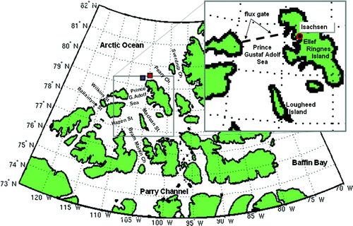
Fig. 1 The Queen Elizabeth Islands (QEI) located in the northern region of the Canadian Arctic Archipelago. The northwestern QEI flux gates as defined in other studies are Ballantyne Strait, Wilkins Strait and the Prince Gustaf Adolf Sea (QEI-South) and Peary Channel and Sverdrup Channel (QEI-North). The Prince Gustaf Adolf Sea flux gate defined in Kwok (Citation2006) and Agnew et al. (Citation2008) is indicated with a black dashed line in the inset. The locations of the ice island fragments bearing CIS satellite-tracked beacons during the week of fast ice breakup (the last week of July 2010) and prior to entry into the QEI are indicated by red (#47560) and blue (#47554) squares. The location of the Isachsen weather station, on the west coast of Ellef Ringnes Island, is shown in the inset.
Sea ice in the narrow channels and straits of the QEI is typically landfast from November to July (CIS, Citation2001). From mid-July to the end of August, the ice breaks up starting in the southeast and ending in the northwest, with the ice plugging the gateways leading from the Arctic Ocean into the QEI normally breaking up last. The ice then reconsolidates from October to mid-November (CIS, Citation2001). Sea ice is, thus, only free to drift within the QEI for a short period of time each year. Because of the brevity of the period during which ice is able to move freely between the Arctic Ocean and the QEI, total annual Arctic sea-ice fluxes into the QEI are small compared with those exiting the Arctic Ocean by other routes (e.g., Fram Strait). Kwok (Citation2006) estimated mean annual area fluxes totalling 8 ± 6 × 10³ km2 for the collective northwestern QEI gates based on 1997–2002 RADARSAT measurements, while Kwok, Cunningham, and Pang (Citation2004) estimated mean annual area fluxes of 8.66 × 10⁵ km2 for Fram Strait for the 1978–2002 period. However, it has been proposed that in summer the fluxes through the CAA become comparable (Mironov & Uralov, Citation1991). This is difficult to verify, however, because spatial and temporal details regarding the net summer MYI fluxes into and through the QEI are sporadic.
Available results indicate that not only is the magnitude of the total annual ice exchange between the Arctic Ocean and the QEI small and uncertain, given the problems of accurately resolving the ice surface using microwave satellite data during the months of July and August (e.g. Agnew et al., Citation2008), but also the MYI fluxes are subject to large intra-seasonal and interannual variability (Agnew et al., Citation2008; Alt et al., Citation2006; Kwok, Citation2006; Mironov & Uralov, Citation1991). The CAA region as a whole has also experienced significant decadal variations in ice transport in the past, with decreased values in the 1960s and increased values in the 1970s (Mironov & Uralov, Citation1991). Notably, between autumn 1963 and summer 1967 there was no ice movement in the Prince Gustaf Adolf Sea or Byam Martin Channel areas of the QEI (Marko, Citation1977). On the other hand, longer-term temporal trends in MYI amounts in the QEI are small (Tivy et al., Citation2011). The MYI concentration trends in the QEI are partly related to the trends in sea-ice fluxes through the area, which in turn are related to trends in break-up and freeze-up dates. Tivy et al. (Citation2011) found that decreasing trends in summer MYI within the QEI are small at 2% per decade from 1968 to 2008. Furthermore, the trends are not uniformly statistically significant or even negative in all parts of the region. Even during September, when sea-ice coverage is at its minimum, the QEI exhibited no significant decrease in MYI from 1979 to 2008 (Howell, Duguay, & Markus, Citation2009). This suggests that there still exists an approximate long-term steady state or equilibrium between incoming and outgoing MYI from the QEI reservoir.
With the aid of the new Canadian Ice Service-Automated Sea Ice Tracking System (CIS-ASITS), RADARSAT-1 and RADARSAT-2 synthetic aperture radar (SAR) images in the Canadian Ice Service archive can now be used to help fill the gaps in our knowledge of sea-ice fluxes through the QEI. In this paper, a series of sea-ice influx events that occurred through the Prince Gustaf Adolf Sea, one of the main gateways for Arctic sea ice entering the QEI (Agnew et al., Citation2008; Black, Citation1965; Kwok, Citation2006), during the 2010 season of ice drift are examined in detail. The aim is twofold. First, the CIS-ASITS ice-motion results in the QEI are validated prior to using them in future, more comprehensive studies. This is done by comparing the ice drifts derived from RADARSAT data to data from two CIS beacons as well as to wind speeds and directions associated with the specific influx events. Second, the high-resolution results of this 2010 case study are used to add to and refine flux estimates and details presented in previous studies. Specifically, the aim of this study is to better establish how ice drifts across this flux gate vary in time (i.e., prior to the end of the melt season versus during the period of active new ice formation) and in space (i.e., spatial uniformity of ice fluxes across this gate) within a given season.
2 Data
a Canadian Ice Service Digital Archive (CISDA)
Weekly total ice, MYI, and first-year ice (FYI) concentrations (in tenths) and area (in square kilometres) in the QEI were extracted from the Canadian Ice Service Digital Archive (CISDA) for 2010. The CISDA is a compilation of CIS regional weekly ice charts that integrate all available real-time sea-ice information from various satellite sensors, aerial reconnaissance, ship reports, operational model results, and the expertise of the experienced ice forecasters. The record spans the period from 1968 to the present (CIS, Citation2007). These digital ice charts are topologically complete polygon ArcInfo Geographic Information System coverages. The CISDA has been found to be more accurate than passive microwave ice concentration retrievals during the melt season (Agnew & Howell, Citation2003). A complete description of the CISDA can be found in Tivy et al. (Citation2011).
b Beacon Data
The positions of two ice island fragments that drifted through the QEI during the 2010 melt season were tracked using MetOcean Compact Air-Launched Ice Beacons (CALIBs) deployed on their surfaces by the CIS. These beacons are Advanced Research and Global Observation Satellite (ARGOS) reporting, battery-powered, mini-beacons used to track ice movement. The CIS beacons were assigned both an ARGOS number and a World Meteorological Organization (WMO) number for tracking purposes via the web. One of the CIS beacons was deployed from a Twin Otter aircraft in May 2009 and was assigned a WMO number of 47560. A second beacon was deployed from the ground after being delivered to the ice island fragment by helicopter in April 2010. This beacon was assigned a WMO number of 47554. Both of these ice islands were located immediately north of the Prince Gustaf Adolf Sea gate at the onset of the 2010 melt season ().
MetOcean CALIBs transmit an omni-directional electromagnetic pulse of information with encoded sensor data every 90 seconds. If an orbiting satellite with an ARGOS instrument receives more than three signals, the surface position (latitude, longitude) of the CALIB can be estimated by triangulation, using the Doppler shift information between successive pulses (Argos, Citation2011). The more signals a satellite receives during an overpass, the more accurately the position of the beacon can be determined.
The positional error in the data reports received for the two CIS beacons is approximately ±0.175 km, based on the radial scatter in sample plots of the downloaded latitude–longitude data during times of limited mobility as a result of winter fast ice. This value is consistent with the <250 m estimated location error cited in the Argos Users Manual (Argos, Citation2011, Section 3.4). Such small inaccuracies in position can lead to very large, spurious, instantaneous velocity calculations when divided by very small time intervals of just a few minutes. For this reason, in this study, the beacon datasets were re-sampled at a lower temporal resolution. An average number of approximately four triangulations per hour are received from the passing satellites. By selecting only every one-hundredth position report (which is equivalent to re-sampling the data at approximately 24-hour intervals), noisiness in the position data and spurious velocity calculations were effectively suppressed.
c Satellite Data
Imagery from both RADARSAT and National Oceanic and Atmospheric Administration (NOAA) satellites were used in this study. With regards to sea-ice studies, the primary advantage of RADARSAT SAR imagery, besides its higher resolution, is the ability of the active microwave sensor to penetrate clouds. Cloudiness in the Arctic is maximum in summer and autumn, when sea-ice extents are minimum and open water is maximum (e.g., Chernokulsky & Mokhov, Citation2012). The primary advantage of NOAA Advanced Very High Resolution Radiometer (AVHRR) imagery, particularly in the infrared channels, is its usefulness in distinguishing between landfast and moving ice. Because fractures in sea ice allow ocean heat to escape, these appear black in the infrared images—in stark contrast to the cold (and therefore white) temperatures of the surrounding sea ice. Boundaries between fast and mobile ice are often not as easy to distinguish visually on RADARSAT imagery.
RADARSAT-1 and RADARSAT-2 ScanSAR Wide imagery, which has a resolution of 100 m pixel−1, was acquired in HH (horizontal transmit, horizontal receive) polarization over the QEI for 2010 from the CIS image archive. RADARSAT satellites have a 24-day repeat cycle with a sun-synchronous, circular near-polar orbit. The on-board active microwave satellite antennas operate in the C-band, with centre frequencies at 5.3 GHz for RADARSAT-1 and at 5.405 GHz for RADARSAT-2. The SAR is right looking in the case of RADARSAT-1, with seven beam modes. In the case of RADARSAT-2, the SAR is both left and right looking, with 12 beam modes as of 2010. For both satellites, these beam modes image the earth's surface at incident angles ranging from 20° to 49° off nadir. ScanSAR Wide images consist of a series of merged beams (Wide 1, 2, 3 and Standard Beams 5, 6 and 7) that are aggregated to produce an approximately 500 km wide swath (CSA, Citation2011). The uncalibrated product is traditionally used by the CIS ice-chart analysts, and in order to be consistent with the CISDA no additional processing of the imagery other than georeferencing and filtering/resampling by the ice motion algorithm was undertaken in this study. The accuracy of the georeferencing for the RADARSAT-2 images used in this study is very similar to that reported for the RADARSAT-1 data used in Wilson, Barber, and King (Citation2001). They reported a mean error for point locations on land of 225 m. Based on a random selection of RADARSAT-2 images covering the Prince Gustaf Adolf Sea as well as on 4–6 point locations at each of the west and east ends of the Prince Gustaf Adolf Sea flux gate (), the average georeferencing error for land was found to vary between 160 and 260 m (a function of both the image and the base map used), with a mean of 200.9 m.
The AVHRR imagery from NOAA's array of polar orbiting satellites (NOAA-15 to NOAA-19) was acquired from the Geographic Information Network of Alaska (GINA; http://www.gina.alaska.edu/) over the QEI for 2010. These images have a nadir resolution of 1.09 km pixel−1. The AVHRR radiometers have five channels. In this study, channels 1 (0.58–0.68 μm) and 2 (0.725–1.0 μm), which make up the “visible” range, and channels 4 (10.30–11.30 μm) and 5 (11.50–12.50 μm), which make up the “infrared” range, were examined.
d Atmospheric Data
Daily mean composite surface wind and sea level pressure (SLP) fields for 2010 (based on NCEP/NCAR reanalysis data; Kalnay et al., Citation1996; Kistler et al., Citation2001) were extracted from the NOAA Earth System Research Laboratory website (NOAA, Citation2011). Hourly wind data for Isachsen station (Ellef Ringnes Island, see ) for 2010 were obtained from the National Climate Data and Information Archive of Environment Canada (Citation2011).
3 Canadian Ice Service-Automated Sea Ice Tracking System (CIS-ASITS)
In this section, the key elements of the CIS-ASITS are briefly outlined. The CIS-ASITS computes the two main components of ice movement (translation and rotation) from two overlapping SAR images that are sequential in time. The full technical details of the CIS-ASITS are available in Komarov (2012).
The CIS-ASITS employs a phase-correlation approach to estimate both the translational and rotational components of any sea-ice motion. The phase correlation method (Karvonen, Simila, & Lehtiranta, Citation2007; Thomas, Geiger, & Kambhamettu, Citation2008) is based on the fact that a shift in the spatial domain transforms into a phase shift in the frequency domain (a property of the Fourier transform). Because Fast Fourier Transforms (FFTs) are available, this method works significantly faster than the alternative cross-correlation approach. In addition, the phase correlation approach can be modified to extract the angle of rotation of ice floes and features in the frequency domain (Reddy & Chatterji, Citation1996). One disadvantage of this approach, however, is that the peak value in the phase correlation matrix does not provide a measure of similarity between two sub-images as is the case for the cross-correlation approach.
Therefore, in addition to the above, the CIS-ASITS also calculates the cross-correlation coefficient in order to estimate the similarity between two sub-images. The cross-correlation matching approach is widely used for various image registration problems (Emery, Fowler, Hawkins, & Prelle, Citation1991; Fily & Rothrock, Citation1987; Heacock, Hirose, Lee, Manore, & Ramsay, Citation1993). This simple method is based on the calculation of the cross-correlation coefficient between the reference sub-image and several trial sub-images from the second image. The maximum correlation coefficient corresponds to the best match, and coordinates of this maximum indicate the shift vector. The cross-correlation method provides a clear measure of the similarity between two sub-images. However, the main disadvantage of this approach is its inability to register the rotational component of sea-ice motion. In addition, the approach is not computationally efficient for situations where the search area is significantly larger than the reference sub-image.
A level of confidence is assigned to each output ice drift vector according to cross-correlation coefficient thresholds prescribed by the user for each pyramid layer (described in the next paragraph). Vectors with scores below these thresholds are rejected, while vectors above the thresholds are assigned confidence levels of low, medium, or high depending on a prescribed confidence level gradation. In this study, cross-correlation thresholds of 0.2 (layer 1), 0.3 (layer 2) and 0.4 (layer 3) were used with a gradation of 0.1. For instance, at the highest resolution layer (layer 1) a drift vector is assigned a low level of confidence if its cross-correlation coefficient is between 0.2 and 0.3, a medium level of confidence if it is between 0.3 and 0.4, and a high level of confidence if it exceeds 0.4.
To assist the CIS-ASITS algorithm with the recognition of likelihood areas in the input images and to reduce the algorithm calculation time further, a pyramid data representation of the input images is used (Fily & Rothrock, Citation1987; Heacock et al., Citation1993; Karvonen et al., Citation2007; Thomas et al., Citation2008). The algorithm is first run for the image pair at 1/8 of the full image resolution, then it is re-run at 1/4 resolution, then at 1/2 resolution and finally at the full resolution; each subsequent run is guided by the vector results from the previous run. This is also an efficient technique for tracking features at different scales. Because of the pyramid nature of the CIS-ASITS algorithm, ice motion results are not significantly affected by reductions in image resolution (to a point); for example, there is normally not a large difference in the computed results based on images that are 100, 200 or 400 m pixel−1 resolution. However, a significant reduction is seen in the numbers and confidence levels of computed ice motion vectors below these resolutions (i.e., at image resolutions of 800 m pixel−1 and lower). At times block averaged or smoothed versions of the images display a better correlation than do the original versions of the data (similar to two smoothed time series). Therefore, in this study, 200 or 400 m pixel−1 results are often used and even occasionally 800 m pixel−1 results are considered. In all experiments, computed drift vectors at all resolutions were examined visually to select the best results (i.e., the resolution with the most vector coverage and highest vector confidence).
Prior to image correlation and vector computation, the CIS-ASITS algorithm selects initial control points at each resolution level of the first (reference) image. Some studies use a set of points located on a regular grid (e.g., Kwok, Curlander, McConnell, & Pang Citation1990), which is convenient for certain subsequent analyses (e.g., assessing sea-ice deformation from the ice motion fields). The CIS-ASITS, on the other hand, employs a set of evenly spread control points over each pyramid level. These are generated in such a way that the following two conditions are taken into account: a) all points should be located at distinctive areas that have relatively high variance (e.g., floe edges, leads and other features); and b) the x and y components of the distance between any two points should not be less than a specified value. The advantage of this method is that identified areas can be recognized more reliably in the second image because they are purposely located at features with high variance. Furthermore, there will typically be no control points over open water. It also allows for a more natural visual assessment of the output ice motion vectors and any ice dynamics (e.g., involving rotation, etc.).
At each resolution level an error filtering step is required to eliminate erroneous ice drift vectors. The CIS-ASITS algorithm uses an error filtering technique which is based on the comparison of ice drift vectors obtained from the forward (tracking from the first image to the second one) and backward (tracking from the second image to the first one) passes of motion detection. A simple thresholding procedure is then applied based on the values of the cross-correlation coefficients.
The primary limitations of the algorithm, as with similar ice tracking algorithms, are evident during the melt season: poor image registration because of 1) large tone differences as a result of varying amounts of surface melt water on the ice floes, and 2) lower ice concentrations and consequently different signatures of the open water in both images due to winds and potentially large drifts of ice floes between image acquisition times. Examples of the limitations of the algorithm during the warm months are highlighted at the beginning of Section 4c in the results presented for August to early September 2010. However, regardless of these limitations, the ice drifts derived from RADARSAT data in this study compare well with those obtained from the tracks of two ice island fragments bearing CIS satellite-tracked beacons, with errors of less than 2 km d−1 in all cases where direct comparisons were possible (Appendix A). Outside the melt season, winter ice motion products are excellent as long as the image separation time is not too large (i.e., a few days in areas of substantial ice drift to a few weeks in areas of limited drift).
4 Results and discussion
a Sea-Ice Evolution in the Queen Elizabeth Islands during 2010: Overview
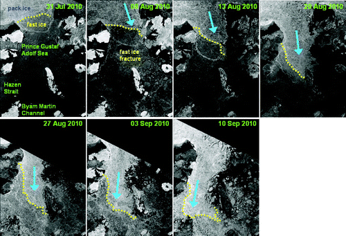
A time series of the evolution of the sea-ice coverage within the QEI during 2010 is shown in . The total ice cover started to decrease in early July with the onset of summer melt and fast ice break-up, reached a minimum in mid-August, then began to increase significantly once again in the first week of September as a result of intrusions of ice from the Arctic Ocean. The MYI component of the time series illustrates the major dynamic loss and Arctic intrusion events that occurred over the 2010 season. A significant MYI loss event occurred from late July to mid-August. According to the CISDA the majority of the land-fast ice in the QEI fractured during the week of 26 July and was able to drift southward out of the QEI because the ice in Parry Channel to the south was already mobile (). By mid-August, a tongue of MYI could be seen exiting Byam Martin Channel and rounding the southeast coast of Melville Island (). Following this initial large MYI loss event, Arctic Ocean ice import events then commenced and the bulk of these occurred in a series of pulses from early August to early October ( and 4). The first intrusion began in the north (around 8 August in the case of the Prince Gustaf Adolf Sea flux gate; ), and lasted until approximately 23 August ( and ). A second period of Arctic MYI influxes followed, beginning the week of 6 September and tapering off toward the week of 27 September (). Both events were initiated and sustained by northerly winds that forced ice through the Prince Gustaf Adolf Sea exchange gate, the ice subsequently reaching and diverging into the western part of Hazen Strait and the northern part of Byam Martin Channel ().
Fig. 2 Weekly evolution of sea-ice conditions within the QEI during 2010. Following the break-up of the fast ice in late July/early August, an initial sudden loss of MYI (right axis) is observed as a result of ice draining southward out of the region. This is followed by periodic intrusions of Arctic Ocean MYI into the QEI resulting in a net increase in total ice over time. The seasonal first-year ice (FYI; left axis), on the other hand, is observed to decrease gradually throughout the melt season and then is rapidly replenished after mid-October by in situ freezing.
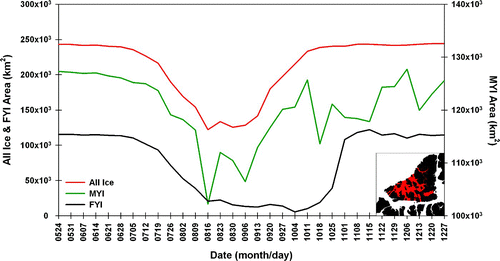
Fig. 3 NOAA AVHRR visible images, showing sea-ice cover in the QEI and the outflow of sea ice from the region through Byam Martin Channel into western Parry Channel during August and early September 2010. Pink arrows illustrate the trajectory of the outflowing sea ice.
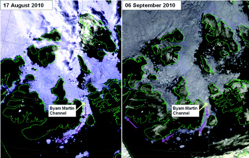
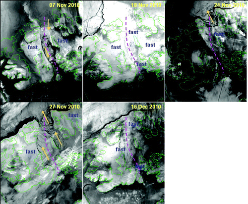
Fig. 4 Time series of RADARSAT-2 images for the period 31 July to 10 September 2010, showing the influx of sea ice from the Arctic Ocean into the Prince Gustaf Adolf Sea in the QEI. The yellow dashed line denotes the leading edge of the intruding Arctic pack ice, which is lighter in tone than the ice in the QEI partly because of a greater concentration of multi-year ice but mainly because of greater ridging and crushing of the Arctic pack ice as a result of its constant mobility throughout the winter months. The large blue arrow shows the direction and extent of the intrusion. RADARSAT-2 Data and Products © MacDONALD, DETTWILER AND ASSOCIATES LTD. (2010) – All Rights Reserved. RADARSAT is an official mark of the Canadian Space Agency.
At the end of the melt season, seasonal FYI began to reform even as some MYI loss continued from 11 to 18 October, primarily through Byam Martin Channel southward (). Import from the Arctic Ocean occurred again from 18 to 25 October (). By 25 October fast ice had formed in Hazen Strait and by 8 November ice movement to the east of Lougheed Island had become relatively small although it was not yet fast (). This limited the freedom of movement of Arctic Ocean pack ice entering the Prince Gustaf Adolf Sea in early November, forcing the incoming ice down a narrowing corridor leading straight towards Byam Martin Channel (). From 16 to 21 November, the ice in the Prince Gustaf Adolf Sea to Byam Martin Channel corridor was fast (). Strong south-southeasterly winds from 24 to 28 November caused the fast ice to re-fracture, first in the Prince Gustaf Adolf Sea on 24 November then, as these strong southerly winds continued, along the entire length of the Gustaf-Byam corridor by 27 November (). This event produced a brief burst of northward ice fluxes, seen as a small interruption in the generally increasing MYI amounts in the QEI that occurred from mid-November to early December (). The fast ice subsequently began to reform gradually in the area during the week of 5 December with arches slowly becoming evident on either side of Byam Martin Island in the south. The ice in the Prince Gustaf Adolf Sea–Byam Martin Channel corridor finally became permanently fast just after mid-December 2010, blocking any further ice fluxes through the QEI ().
Fig. 5 A time series of NOAA AVHRR infrared images showing the progression of fast ice formation in the corridor between the Prince Gustaf Adolf Sea and Byam Martin Channel (highlighted with a pink dashed line) in 2010. Yellow-orange arrows indicate the direction of ice drift.
b Beacon Ice Drift
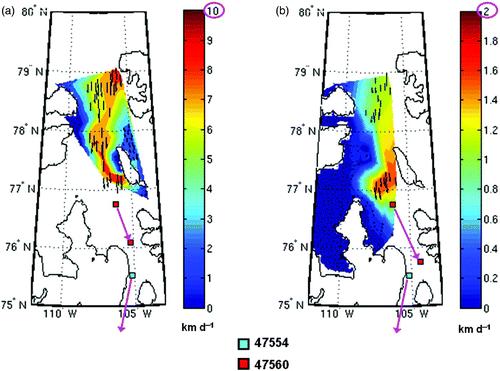
In August 2010, two CIS-instrumented ice island fragments in the Arctic Ocean entered the QEI via the Prince Gustaf Adolf Sea. Throughout the melt season and during the onset of freeze-up, these ice islands transited the QEI to Byam Martin Channel (a). Based on their positions, the leading fragment (beacon #47554) passed through the Prince Gustaf Adolf Sea gate between 12 and 14 August 2010, with an average drift speed of approximately 20 km d−1 (b). This fragment exited the QEI through Byam Martin Channel in late October and could subsequently be found frozen into the fast ice in Viscount Melville Sound in December 2010. The second fragment (beacon #47560) passed through the Prince Gustaf Adolf Sea gate between 15 and 17 August with an average drift speed of approximately 20 km d−1 (), though even greater drift speeds of approximately 30 km d−1 were observed just prior to this crossing. This fragment reached Byam Martin Channel in late November where it froze in place in the fast ice in the first few days of December.
Fig. 6 a) The tracks of two ice island fragments bearing Canadian Ice Service satellite-tracked beacons #47560 (red) and #47554 (blue) that entered the QEI in August 2010 through the Prince Gustaf Adolf Sea. b) Latitudinal or meridional velocity component of the ice island fragments during their track southward through the QEI.
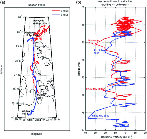
Over the period 10 August to 10 December 2010, the leading fragment (#47554) travelled from 79.25°N to 74.20°N, for an average meridional transit velocity of 4.6 km d−1 (). Over the same period, the lagging fragment (#47560) travelled from 79.51°N to 75.76°N, for an average meridional transit velocity of 3.4 km d−1. These velocities are consistent with the lower end of the range estimated by Melling (Citation2002). Based on the tracking of distinctive ice floes in satellite imagery, Melling (Citation2002) cited typical transit speeds from the Arctic Ocean to Parry Channel of 4.32 to 8.64 km d−1. He noted that drift speeds through certain constricted areas of the QEI (e.g., Byam Martin Channel and Penny Strait) can be twice the average speeds observed elsewhere, and these may be responsible for the higher values of his reported range of average transit times. Additionally, as is evident from the drift speeds observed when the 2010 fragments entered the QEI, short-term velocities can be ten times greater than the mean during certain wind events. This was particularly evident in 1962 when ice island T1, located on the east side of Lougheed Island, drifted at approximately 40 km d−1 from MacLean Strait to Byam Martin Channel (Marko, Citation1977).
Although sea ice and ice islands are both generally observed to drift at 1–2% of the wind speed (Jeffries, Citation1992; Sackinger, Jeffries, Li, & Lu, Citation1991; Thorndike & Colony, Citation1982), their turning angles (degree of deviation from the surface wind direction due to the Coriolis force) can be quite different (Jeffries, Citation1992; Sackinger et al., Citation1991). However, pack ice stresses on ice islands within a concentrated ice pack can significantly modify ice island drifts and reduce their large turning angles (Jeffries, Citation1992; Sackinger et al., Citation1991). In Antarctica, it has been observed that pack ice stresses can “lock in” giant tabular icebergs so that they drift with the sea ice (Lichey & Hellmer, Citation2001). The 2010 ice islands discussed in this study were embedded within very close-packed multi-year sea ice and were observed to drift with the pack ice (i.e., no “wakes” were observed in the satellite imagery indicating that these fragments were drifting more slowly, more quickly, or in a direction different from the surrounding sea ice).
c RADARSAT Ice Drift
A time series of six RADARSAT images with superimposed CIS-ASITS ice drift vectors, covering the Prince Gustaf Adolf Sea to Byam Martin Channel corridor of the QEI, from 31 July to 10 September is shown in . This time series highlights the limitations of SAR-based sea-ice tracking algorithms during periods of high surface melt, which are all the more problematic within the QEI where most of the ice movement occurs during the summer and fall. As can be seen, ice drifts for the image pairs with the longer time separation intervals (7–8 days) were not well resolved by the CIS-ASITS in the QEI during the peak of the melt season as a result of reduced image correlations. The image pair with the shortest time separation (approximately five days, covering 8 to 13 August) produced the best ice drift results through the Prince Gustaf Adolf Sea gate during this period and captured the onset of the first large influx event of sea ice from the Arctic Ocean into this part of the QEI ( and 8a). Results for the image pairs from 27 August to 3 September and 3 to 10 September produced adequate vector numbers and confidence levels through the Prince Gustaf Adolf Sea but only for areas south of the actual Gustaf flux gate. These pairs, respectively, captured the reduction in ice motion following the mid-August event and a subsequent increase in motion corresponding to a second, smaller early September influx event (, c and 9a).
Fig. 7 RADARSAT-derived average ice drift velocities for the period 31 July to 10 September 2010, based on the successive pairs of images shown in . The vector colours represent the confidence levels, determined by prescribed image cross-correlation coefficient thresholds, where green is high and red is low. The vectors are plotted on the first of the two images in a given pair and are shown for the image resolution (200,400 or 800 m pixel−1) which produced the best correlations (and thus vector numbers and confidence levels). RADARSAT-2 Data and Products © MacDONALD, DETTWILER AND ASSOCIATES LTD. (2010) – All Rights Reserved. RADARSAT is an official mark of the Canadian Space Agency.
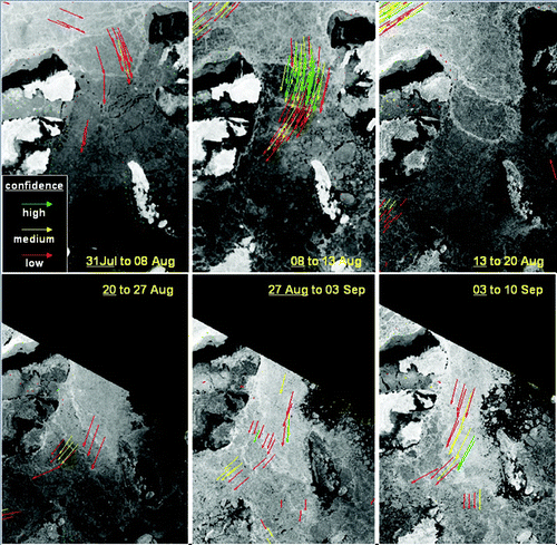
Fig. 8 RADARAT-derived average ice drift velocities for August 2010: a) 8–13 August, a 5-day period which captured the beginning of the first large Arctic sea-ice influx into the QEI through the Prince Gustaf Adolf Sea flux gate; b) 11–13 August, a 2-day period leading into the peak of the influx pulse, which occurred around mid-August; c) 27 August to 3 September, a 7-day period following the mid-August influx pulse as it tapered off towards the end of August. The length of the arrows in the plots is proportional to the total displacement of ice features between the two image times. The speed of the ice motion is indicated by the coloured contours. The leading ice island fragment (beacon #47554, light blue square) passed through the Prince Gustaf Adolf Sea flux gate (i.e., crossed the line between Borden Island and Ellef Ringnes Island as defined in the literature) between the 12 and 14 August 2010.
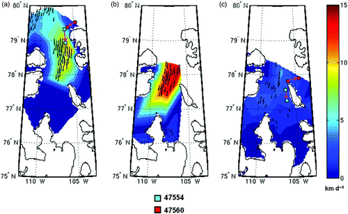
The magnitude and direction of computed ice drifts based on the 8–13 August pair indicate maximum average speeds of 10 km d−1 during this period and reveal a pattern in which maximum ice drifts are concentrated towards the eastern side of the Prince Gustaf Adolf Sea flux gate (a). The magnitude and direction of computed ice drifts based on a secondary 11–13 August image pair indicate average maximum speeds of 14+ km d−1 for this shorter period leading up to the peak of the mid-August influx pulse and also point to maximum ice velocities preferentially located along the eastern side of the Prince Gustaf Adolf Sea (b). Based on CMC data for the 11–19 August period, maximum sustained northerly wind speeds of 55 km h−1 occurred on 14 August (). Thus, the RADARSAT-derived ice drifts shown here (a and 8b) only capture the onset of the 11–19 August influx event and not its peak (because of the unavailability of RADARSAT images around 14 August). Over the period 11 to 13 August (corresponding to the period in b) winds averaged approximately 37 km h−1 (). An ice drift of 2% of the wind speed (as is commonly observed; Nansen, Citation1902; Thorndike & Colony, Citation1982) would have been 17.8 km d−1, which is consistent with the 14+ km d−1 derived from the RADARSAT imagery for this period. The leading ice island fragment (beacon #47554) passed through the Prince Gustaf Adolf Sea flux gate between the 12 and 14 August 2010 with a drift speed of 20 km d−1. Because the ice island's track hugged the eastern side of the flux gate, it passed through the areas of maximum ice drifts indicated in the results from the RADARSAT images (a and 8b).
In the wake of the mid-August influx event, the magnitude of the computed ice drifts decreased to maximum average speeds of 5 km d−1 and lower, though still in a southward direction, based on the 27 August to 3 September image pair (c). During this period, the leading ice island fragment (beacon #47554) drifted southwards along the west coast of Lougheed Island while the lagging fragment (beacon #47560) diverged eastward into Maclean Strait (c). Following this interlude, the magnitude of the computed ice drifts increased slightly once again, based on the 3–10 September image pair, and maximum average speeds of 6 km d−1 and higher were observed (a). This velocity increase produced a second, smaller influx event and was driven by north winds reaching 30+ km h−1 from 3 to 7 September (). For the remainder of September, leading up to the onset of freeze-up, average north-to-south ice drifts prevailed but remained small (b and 9c), as did corresponding wind speeds (). The magnitude and direction of computed ice drifts based on a RADARSAT image pair for 10–22 September show southward maxima averaging approximately 3 km d−1 or higher on the east side of the Prince Gustaf Adolf Sea gate and also at the head of Byam Martin Channel during this period (b). The magnitude and direction of computed ice drifts based on a RADARSAT image pair for 22–26 September show slightly higher southward maxima of approximately 4+ km d−1 on the east side of the Prince Gustaf Adolf Sea gate, reaching 5+ km d−1 through the middle of Byam Martin Channel (c).
Fig. 9 RADARSAT-derived average sea-ice motion for September 2010: a) 3–10 September, a second wind-driven influx event through the Prince Gustaf Adolf gate occurred during this 7-day period; b) 10–22 September, the two weeks spanning the peak of the Arctic melt season; and c) 22–26 September, a weak burst of northerly winds occurred at the onset of freeze-up in the QEI. The length of the pink arrows in panels a) and b) denoting the direction of motion of beacon #47554 were exaggerated in these plots for the sake of clarity.
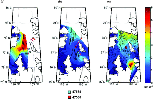
Fig. 10 Time series of mean hourly wind speed (km h−1) at Isachsen station, on the west coast of Ellef Ringnes Island, spanning July to mid-December 2010. Wind data with a northerly directional component are blue in the plot; wind data with a southerly directional component are red. The dates of significant wind events with a northerly component are noted.
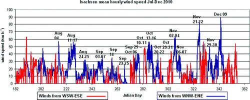
During the 22–26 September period, NCEP data (not shown) indicate high SLPs approaching the Prince Gustaf Adolf Sea from the west. Winds were generally light except for a period from late on 23 September to early on 25 September when winds averaged 10–15 km h−1 from the north, briefly peaking at approximately 26 km h−1 at 0000 utc on 25 September at Isachsen station (). As a result, average ice drifts from the Arctic Ocean into the Prince Gustaf Adolf Sea computed from RADARSAT imagery during this period are close to ocean surface current velocities in the area, which are southward and between 1.85 and 7.4 km d−1 (CIS, Citation2001; Fissel, Birch, Melling, & Lake, Citation1988). CIS-ASITS ice drifts derived from images spanning two subsets from this period, 22–24 September and 24–26 September, indicate that southward velocities were generally approximately 5 km d−1 during the first half of the period with a small maximum of 6 km d−1 near the northwest point of Ellef Ringnes Island (a and 11b). These drift speeds are consistent with a value that is 2% of the brief 10–15 km h−1 northerly wind episode that occurred. During the second half of the period, ice drifts passing through the vicinity of the flux gate averaged 2 km d−1 or lower except for an area of approximately 3.5 km d−1 along the west coast of Ellef Ringnes Island (c and 11d). These drift speeds are consistent with ocean surface current data (CIS, Citation2001) and are approximately representative of the mean background ice drift state during the season of free ice drift when winds are not an important forcing factor.
Fig. 11 Temporal and spatial details of the ice drifts associated with a weak burst of northerly winds at the end of September (22–26 September; c): a) and b) ice drifts into the Prince Gustaf Adolf Sea computed from two sets of RADARSAT-1/RADARSAT-2 images spanning 22–24 September; c) and d) ice drifts into the Prince Gustaf Adolf Sea computed from two sets of RADARSAT-1/RADARSAT-2 images spanning 24–26 September. The flux gate defined in Kwok (Citation2006) and Agnew et al. (Citation2008) is indicated by a black dashed line. The positions of beacons 47554 (cyan squares) and 47560 (red squares) on the 22 and 26 September are shown in panels b) and d).
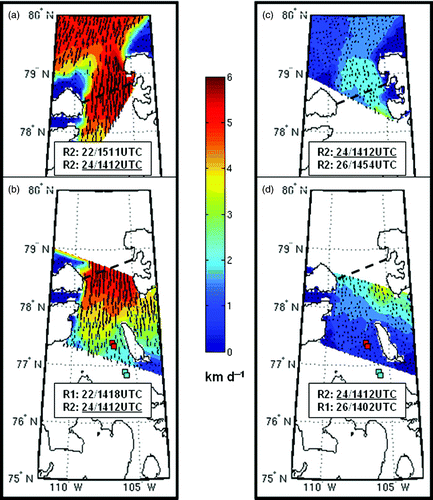
There are two further items related to the computed ice drifts in c to note. 1) The CIS-ASITS results for the 22–26 September image pair show maximum ice velocities in the Prince Gustaf Adolf Sea and in Byam Martin Channel at the ends of the corridor where the ocean and ice flow are constricted by islands to the east and west. In the middle of the corridor, where the ocean and ice flow are free to diverge west into Hazen Strait and east into MacLean Strait, the magnitude of the north–south ice drift is diminished. The decrease in ice drifts in the middle of the corridor may also be caused by ice congestion and resultant internal frictional ice stresses. 2) All derived ice motion plots in this study with good vector coverage (e.g., ), including those for the very light-wind 24–26 September image pairs (), show an eastward increase in velocity across the Prince Gustaf Adolf Sea flux gate. Even some of the figures with only a partial vector coverage hint at a velocity maximum on the east side (e.g., b). One plausible explanation for this is that the ocean current along the west coast of Ellef Ringnes Island is stronger than further out in the channel and that it enhances northerly wind-driven ice motion in this area. Another possible explanation is that because ice drifts a few degrees to the right of the wind direction as a result of the Coriolis effect, some ice compression will occur against the western shore of the Prince Gustaf Adolf Sea during north-northwesterly wind events, increasing the internal ice stress in this area, thus, slowing the ice drift.
No RADARSAT images with satisfactory coverage of the Prince Gustaf Adolf Sea to Byam Martin Channel corridor were available in the CIS image archive for the month of October 2010, a period which experienced a number of ice flux events () and associated wind events, both northerly and southerly (). With the onset of freeze-up and the end of the Arctic shipping season, CIS RADARSAT image acquisition frequency which was daily to weekly during the season becomes (bi)weekly to monthly over this area. However, a RADARSAT image pair for the 1–6 November period captured the last significant influx event of the 2010 season (a), associated with a northerly wind event during which wind speeds reached 60+ km h−1 (). Computed ice drifts from this image pair reached maxima of 8+ km d−1 along the route through the Prince Gustaf Adolf Sea and into the top of Byam Martin Channel (a). Note that at this stage of the season, ice in the QEI is no longer completely free to move because of the formation of young and FYI between the ice floes. Ice drifts derived from RADARSAT imagery during this period also illustrate the impact of the narrowing of the Prince Gustaf Adolf Sea to Byam Martin Channel corridor caused by the formation of fast ice on either side (). A consequent funnelling of the ice flow can be seen in the pattern of the derived drift vectors (a). The strong northerly wind event, which spanned 1–7 November, helped to keep ice in the Prince Gustaf Adolf Sea–Byam Martin Channel corridor moving and prevent it from becoming landfast during this stage of the freeze-up season. This large north–south ice drift event was also observed in the beacon tracks over the image separation period from 1 to 6 November (b and 12a). The velocity of the lagging beacon (#47560), which passed into the central section of Byam Martin Channel during this event reached nearly 25 km d−1, indicating that the ice drift velocities derived from RADARSAT imagery to the south of Lougheed Island only captured the northern edge of a much larger maximum extending southwards from the island (b and 12a).
Fig. 12 RADARSAT-derived sea-ice motion from imagery acquired in November and December 2010: a) 1 to 6 November, the week which experienced the last significant wind-driven influx event of the season; and b) 1 November to 13 December, the month spanning the final freeze-up and formation of fast ice in the QEI which experiences a significant slow-down and finally a cessation in ice motion. Note the difference in the magnitudes of the velocity scales of the two panels.
No RADARSAT images were available over the Prince Gustaf Adolf Sea to Byam Martin Channel corridor from 15 November to 5 December. As a result, an examination of the fast ice breakout event of 24–28 November (, panels 3 and 4), associated with a southerly wind event during which winds reached 50+ km h−1 () and the ensuing brief period of northward ice fluxes, is not possible. However, a general picture of the average ice drifts from 1 November to 13 December is possible based on two RADARSAT images from these bracketing dates. Computed ice drifts clearly demonstrate the formation of fast ice to the west of the Prince Gustaf Adolf–Byam Martin Channel corridor during the November to mid-December stage of freeze-up, while some ice drift in a net southward direction and averaging up to 1.5 km d−1 continued within the corridor itself (b). This is consistent with climatology; fast ice normally forms first to the west of the Prince Gustaf Adolf Sea–Byam Martin Channel corridor, generally by mid-October (CIS, Citation2001).
d Meteorological Forcing: Discussion
It seems apparent from the ice drifts derived from RADARSAT imagery discussed above that sea-ice motion into the QEI through the Prince Gustaf Adolf Sea gate and into Byam Martin Channel mainly occurs as a series of atmospherically driven pulsed events, with currents playing a background role. The orbital motions along the tracks of the ice island fragments correspond to the changing wind directions associated with passing low pressure systems (). During periods of no wind or light wind, free ice drifts are comparable to, or slightly less than, the southward ocean currents which are recorded at an average of 4.6 km d−1 (CIS, Citation2001; Fissel et al. Citation1988). However, during strong wind events, these drifts can be greatly enhanced or dampened, depending on the direction of the wind. For example, northerly winds associated with a low SLP system that tracked south of the QEI from 10 to 20 August () were responsible for the first legs of the ice islands' tracks into the QEI, during which they entered the Prince Gustaf Adolf Sea and drifted nearly straight south towards Lougheed Island (). Sustained wind speeds recorded on Ellef Ringnes Island during this period neared 60 km h−1 (). Given that ice floes within a concentrated pack normally drift at velocities around 2% of the wind speed (Nansen, Citation1902; Thorndike & Colony, Citation1982), this would produce ice drift velocities of approximately 30 km d−1, as observed when the beacons passed through the Prince Gustaf Adolf Sea flux gate (). This atmospherically driven ice drift within the QEI is also in agreement with Black (Citation1965) who found that the invasion of Arctic Ocean ice into the Prince Gustaf Adolf Sea gate in 1962 was predominately caused by powerful north-northwesterly winds that transported the sea ice at 16 to 21 km d−1.
Northerly winds to the west of a low SLP system from 1 to 7 November () were also responsible for 1) the final significant influx of Arctic ice into the QEI through the Gustaf gate; 2) keeping the Prince Gustaf Adolf–Byam Martin Channel corridor open at a time when fast ice had set in to the west and was in the process of setting in to the east; and 3) the final legs of the ice islands' tracks before they became immobilized in the fast ice within and to the south of Byam Martin Channel (). Wind speeds during this period reached 60+ km h−1 and averaged over 30 km h−1, but ice drifts in this case only reached 8+ km d−1 (much less than 2% of the average wind speed) because of the active formation of new and young ice between the ice floes.
e Sea-Ice Area Flux: Putting the 2010 Ice Drift Results in Context with Previous Studies
It is difficult to construct a monthly 2010 ice flux time series for the Prince Gustaf Adolf Sea flux gate similar to those of Kwok (Citation2006) and Agnew et al. (Citation2008) using the drifts computed from RADARSAT image pairs found in the CIS archive because of the seasonally varying frequency of CIS image acquisitions. However, useful ice flux information can nevertheless be extracted from the obtainable results.
This study, similar to the studies of Kwok (2006) and Agnew et al. (Citation2008), shows that ice area fluxes into and out of the QEI are episodic and that large changes in daily ice import and export during periods when the ice is mobile are driven by synoptic weather events. This produces a small average net influx of ice into the QEI over months and years. Although Agnew et al. (Citation2008) were not able to calculate fluxes in August from the Advanced Microwave Scanning Radiometer-Earth observing system (AMSR-E) data because of atmospheric water vapour attenuation, their results show net monthly influxes (over the 2002–06 period) through the QEI-South gates in September and October with the largest average monthly cumulative fluxes (approximately 4100 km2) occurring in September whereas those in October averaged less than 2000 km2. Kwok (Citation2006), on the other hand, based on RADARSAT data, shows net monthly influxes through the QEI-South gates from August to October with peaks in August and October of approximately 3000 km2 (over the 1997–2002 period) and with average September fluxes less than 2000 km2. The studies of Agnew et al. (2008) and Kwok (Citation2006) overlap by only one year (2002), and in that year their results agree that maximum influxes (approximately 7500 km2) occurred in September as a result of the very late break-up of the fast ice in the QEI-South gates. Another year with very late and limited fast ice break-up was 2004 and, together with 2002, probably helped create the large September flux peak in the Agnew et al. (Citation2008) study. On the other hand, the strong September outfluxes in 1998 probably helped suppress the average September fluxes reported in Kwok (Citation2006). In the present study, although no results are available for October, computed August ice drifts through the Prince Gustaf Adolf flux gate were larger than those computed for September (cf. and ). The temporal pattern in ice fluxes in 2010 was, therefore, similar to the average for 1997–2002, when the net fluxes in August were found to be greater than those in September (Kwok, Citation2006). The large southward ice drifts in August 2010, which were also observed in the beacon data, were related to the first large influx event of the 2010 season following the break-up of the fast ice.
Kwok's (Citation2006) mean annual area fluxes for the QEI-South gates (6 ± 5 × 10³ km2) correspond to a mean daily drift rate of 0.9 km d−1, assuming an average 1997–2002 mobile ice season of approximately 65 days (based on CISDA data) and that all the net ice flow during this 5-year period was through the Prince Gustaf Adolf Sea gate and that the Ballantyne and Wilkins Straits are for the most part irrelevant. This mean daily drift rate is somewhat less than the light wind, current-driven drift rates through the Prince Gustaf Adolf Sea gate computed in this study for 24–26 September 2010, which ranged from 1.5 to 2 km d−1 on the west side of the gate to 2–3.5 km d−1 on the east side (c and 11d). Rather it is more comparable to the mean southward drift rates computed for 1 November to 13 December 2010, a time of increasingly limited drift but periodically strong northerly wind events, when mean drift rates varied from approximately 0.5 km d−1 on the west side of the Prince Gustaf Adolf Sea gate but reached more than 1 km d−1 on the east side (b). Allowing for Kwok's (Citation2006) error margin of ±5 × 10³ km2, his maximum average daily drift rate for 1997–2002 is computed to be approximately 1.7 km d−1 under the given assumptions. This is closer to the light-wind September values of this study and also closer to the lower end of the range of values for currents in the area (1.85 to 7.4 km d−1; CIS, Citation2001). Given that the net southward ice fluxes through the QEI-South gates are driven by currents as well as winds and given the prevalence of northerly winds through the Prince Gustaf Adolf Sea (; for other years, see Environment Canada (Citation2011)), one might, at minimum, expect seasonal average ice drifts to reflect the mean ocean currents in the area in magnitude as well as direction. Knowledge of the actual details of ocean currents through the Prince Gustaf Adolf Sea is sparse, however; therefore, any examination of ice-drift versus ocean-current discrepancies can only be tentative. It is also possible that estimated seasonal average drifts are skewed toward the lower end of the magnitude range for currents in the area for other reasons. For example, the discrepancy may be the result of the slowing of the ice drifts caused by new and young ice formation between the MYI floes from the end of September onwards.
5 Conclusions
In this study, the sea-ice flux events that occurred through the Prince Gustaf Adolf Sea flux gate into the QEI over the 2010 mobile ice season were investigated using ice drift velocities derived from RADARSAT imagery, leading to the following conclusions.
| • | RADARSAT-derived ice drifts compared well with those obtained from the tracks of two ice island fragments bearing CIS satellite-tracked beacons, with errors less than 2 km d−1 in all cases where direct comparisons were possible (Appendix A). | ||||
| • | Winds, both their direction and magnitude, played a major role in the observed temporal drift variations during the 2010 period of mobile ice. Once internal ice stresses were no longer dominant, and the ice was drifting freely, ice drift rates were 1–2% of the observed wind speed. During freeze-up, winds decreased in importance as internal ice stresses regained their dominance through the formation of new and young ice between the mobile floes and through the formation of landfast ice areas. | ||||
| • | Southward ice drifts of 1.5 to 3.5 km d−1, computed during episodes of very light winds prior to the onset of freeze-up, likely reflect the residual ocean currents of that season and are within the range of estimated average ocean current velocities for the area (1.85 to 7.4 km d−1; CIS, Citation2001). | ||||
| • | Southward ice drifts, both during periods of calm winds and episodes of northerly winds, were faster down the eastern side of the Prince Gustaf Adolf Sea than down the western side by factors up to two. Because this was true even during periods when winds were very light to absent, one possible explanation is that southward currents through the Prince Gustaf Adolf Sea tend to be stronger along the west coast of Ellef Ringnes Island than farther out in the channel. While other explanations for the observed east–west velocity gradients in ice drift (e.g., those related to wind-induced internal ice stresses) cannot be ignored based upon the limited data in this single-year study, the 2010 results nevertheless reveal the potential for using RADARSAT-derived ice motion to expand upon the limited knowledge of ocean currents within the QEI, in addition to refining estimates of ice flux magnitudes and spatial patterns in this area. | ||||
Although limited in time and space, the findings of this study will help provide some much needed baseline data for ice–ocean modelling studies of the QEI in an area where data are sparse (e.g., Sou & Flato, Citation2009; Terwisscha van Scheltinga, Myers, & Pietrzak, Citation2010). Such studies seek to model present and future sea-ice flux variations in response to changes in atmospheric forcing. Detailed knowledge of sea-ice drift responses to various wind forcing scenarios is, therefore, crucial for realistic numerical representations of area and volume fluxes through the important Prince Gustaf Adolf Sea flux gate.
Acknowledgements
This work was funded by the Canadian Space Agency through the Government Related Initiatives Program. We would like to thank our reviewers for their many helpful suggestions which greatly improved the readability of the manuscript.
Related Research Data
References
- Agnew , T. and Howell , S. 2003 . The use of operational ice charts for evaluating passive microwave ice concentration data . Atmosphere-Ocean , 41 ( 4 ) : 317 – 331 . doi:10.3137/ao.410405
- Agnew , T. , Lambe , A. and Long , D. 2008 . Estimating sea ice area flux across the Canadian Arctic Archipelago using enhanced AMSR-E . Journal of Geophysical Research , 113 : C10011 doi:10.1029/2007JC004582
- Alt , B. , Wilson , K. and Carrieres , T. 2006 . A case study of old ice import and export through Peary and Sverdrup channels in the Canadian Arctic Archipelago: 1998–2004 . Annals of Glaciology , 44 : 329 – 338 . doi:10.3189/172756406781811321
- Argos. (2011). Argos User’s Manual : Worldwide tracking and environmental monitoring by satellite. Collecte Localisation Satellites [online manual]. Retrieved from http://www.argos-system.org/manual/index.html
- Black, W. A. (1965). Sea-Ice Survey, Queen Elizabeth Islands Region, Summer 1962. Geographical Paper No. 39, Queens Printer, Ottawa, Ontario, Canada.
- CIS (Canadian Ice Service). (2001). Sea ice climatic atlas for northern Canadian waters 1971–2000. Environment Canada, Ottawa, Canada. Retrieved from http://www.ec.gc.ca/glaces-ice/default.asp?lang=En&n=090AF7D6-1&xml=DE118B27-ED3C-4882-B049-6F7A798B82C2
- CIS (Canadian Ice Service). (2007). Regional charts: History, accuracy, and caveats. Arch. Ser. Doc. Ser. 1, Ottawa, Canada. Retrieved from http://ice.ec.gc.ca/IA_DOC/cisads_no_001_e.pdf
- CSA (Canadian Space Agency). (2011). RADARSAT systems: Satellite characteristics. Saint-Hubert, Quebec, Canada. Retrieved from http://www.asc-csa.gc.ca/eng/satellites/radarsat/radarsat-tableau.asp
- Chernokulsky , A. V. and Mokhov , I. I. 2012 . Climatology of total cloudiness in the Arctic: An intercomparison of observations and reanalyses . Advances in Meteorolology , 2012 : 542093 doi:10.1155/2012/542093
- Emery , W. , Fowler , C. , Hawkins , J. and Prelle , R. 1991 . Fram Strait satellite image-derived ice motions . Journal of Geophysical Research , 96 ( C3 ) : 4751 – 4768 . (doi:10.1029/90JC02273)
- Environment Canada. (2011). National Climate Data And Information Archive [Data]. Retrieved from http://www.climate.weatheroffice.gc.ca/Welcome_e.html
- Fily , M. and Rothrock , D. 1987 . Sea ice tracking by nested correlations . IEEE Transactions on Geoscience and Remote Sensing , GE-25 ( 5 ) : 570 – 580 . (doi:10.1109/TGRS.1987.289836)
- Fissel, D. B., Birch, J. R., Melling, H., & Lake, R. A. (1988). Non-tidal flows in the Northwest Passage. Canadian Technical Report of Hydrography and Ocean Sciences No. 98, Department of Fisheries and Oceans, Sidney, British Columbia.
- Heacock , T. , Hirose , T. , Lee , F. , Manore , M. and Ramsay , B. 1993 . Sea-ice tracking on the east coast of Canada using NOAA AVHRR imagery . Annals of Glaciology , 17 : 405 – 413 .
- Howell , S. E. L. , Duguay , C. R. and Markus , T. 2009 . Sea ice conditions and melt season duration variability within the Canadian Arctic Archipelago: 1979–2008 . Geophysical Research Letters , 36 : L10502 doi:10.1029/2009GL037681
- Howell , S. E. L. , Tivy , A. , Yackel , J. J. , Else , B. G. T. and Duguay , C. R. 2008 . Changing sea ice melt parameters in the Canadian Arctic Archipelago: Implications for the future presence of multiyear ice . Journal of Geophysical Research , 113 : C09030 doi:10.1029/2008JC004730
- Jeffries , M. 1992 . Arctic ice shelves and ice islands: Origin, growth and disintegration, physical characteristics, structural-stratigraphic variability, and dynamics . Reviews of Geophysics , 30 ( 3 ) : 245 – 267 . (doi:10.1029/92RG00956)
- Kalnay , E. , Kanamitsu , M. , Kistler , R. , Collins , W. , Deaven , D. , Gandin , L. , Iredell , M. , Saha , S. , White , G. , Woollen , J. , Zhu , Y. , Chelliah , M. , Ebisuzaki , W. , Higgins , W. , Janowiak , J. , Mo , K. C. , Ropelewski , C. , Wang , J. , Leetmaa , A. , Reynolds , R. , Jenne , R. and Joseph , D. 1996 . The NCEP/NCAR 40-year reanalysis project . Bulletin of the American Meteorological Society , 77 ( 3 ) : 437 – 471 . (doi:10.1175/1520-0477(1996)077<0437:TNYRP>2.0.CO;2)
- Karvonen, J., Simila, M., & Lehtiranta, J. (2007). SAR-based estimation of the Baltic sea ice motion. In Proceedings of the International Geoscience and Remote Sensing Symposium 2007 (IGARSS-07) (pp. 2605–2608). Barcelona, Spain: IEEE.
- Kistler , R. , Kalnay , E. , Collins , W. , Saha , S. , White , G. , Woollen , J. , Chelliah , M. , Ebisuzaki , W. , Kanamitsu , M. , Kousky , V. , van den Dool , H. , Jenne , R. and Fiorino , M. 2001 . The NCEP–NCAR 50-year reanalysis: Monthly means CD-ROM and documentation . Bulletin of the American Meteorological Society , 82 : 247 – 267 . (doi:10.1175/1520-0477(2001)082<0247:TNNYRM>2.3.CO;2)
- Komarov, A., and Barber, D. (2012). Sea ice motion tracking from sequential dual-polarization RADARSAT-2 images. IEEE Transactions on Geoscience and Remote Sensing. In press.
- Kwok , R. 2006 . Exchange of sea ice between the Arctic Ocean and the Canadian Arctic Archipelago . Geophysical Research Letters , 33 : L16501 doi:10.1029/2006GL027094
- Kwok , R. , Cunningham , G. F. and Pang , S. S. 2004 . Fram Strait sea ice outflow . Journal of Geophysical Research , 109 : C01009 doi:10.1029/2003JC001785
- Kwok , R. , Curlander , J. C. , McConnell , R. and Pang , S. S. 1990 . An ice-motion tracking system at the Alaska SAR facility . IEEE Journal of Oceanic Engineering , 15 ( 1 ) : 44 – 54 . (doi:10.1109/48.46835)
- Lichey , C. and Hellmer , H. H. 2001 . Modeling giant-iceberg drift under the influence of sea ice in the Weddell Sea, Antarctica . Journal of Glaciology , 47 ( 158 ) : 452 – 460 . (doi:10.3189/172756501781832133)
- Marko, J. R. (1977). A satellite-based study of sea ice dynamics in the central Canadian Arctic Archipelago. Contractor Rep. Ser. 77-4, Library, Institute of Ocean Sciences, Sidney, British Columbia.
- Melling , H. 2002 . Sea ice of the northern Canadian Arctic Archipelago . Journal of Geophysical Research , 107 ( C11 ) : 3181 doi:10.1029/2001JC001102
- Mironov, Ye. U., & Uralov, N. S. (1991). Year-to-year variations of the ice transport from the Arctic basin through some straits of the Canadian Arctic Archipelago and Fram Strait. Glaciers-Ocean-Atmosphere Interactions. In Proceedings of the International Symposium, September 1990. International Association of Hydrological Sciences (IAHS) Publ. no. 208. St Petersburg, Russia.
- Nansen , F. 1902 . The oceanography of the North Polar Basin, Norwegian North Polar Expedition 1893–1896 . Scientific Results , 3 ( 9 ) : 1 – 427 .
- NOAA. (2011). Daily mean composites [Data]. Retrieved from the Earth System Research Laboratory, Physical Sciences Division: http://www.esrl.noaa.gov/psd/data/composites/day/
- Reddy , S. and Chatterji , B. 1996 . An FFT-based technique for translation, rotation, and scale-invariant image registration . IEEE Transactions on Image Processing , 5 ( 8 ) : 1266 – 1271 . (doi:10.1109/83.506761)
- Sackinger, W. M., Jeffries, M. O., Li, F., & Lu, M. (1991). Ice island creation, drift, recurrences, mechanical properties, and interactions with Arctic offshore oil production structures. U.S. Department of Energy Report (Contract No. DE-FG21-88MC25027). University of Alaska at Fairbanks (Geophysical Institute), Fairbanks, Alaska.
- Sou , T. and Flato , G. 2009 . Sea ice in the Canadian Arctic Archipelago: Modeling the past (1950–2004) and the future (2041–60) . Journal of Climate , 22 : 2181 – 2198 . (doi:10.1175/2008JCLI2335.1)
- Terwisscha van Scheltinga , A. D. , Myers , P. G. and Pietrzak , J. D. 2010 . A finite element sea ice model of the Canadian Arctic Archipelago . Ocean Dynamics , 60 : 1539 – 1558 . doi:10.1007/s10236-010-0356-5
- Thomas , M. , Geiger , C. and Kambhamettu , C. 2008 . High resolution (400 m) motion characterization of sea ice using ERS-1 SAR imagery . Journal of Cold Regions Science and Technology , 52 : 207 – 223 . (doi:10.1016/j.coldregions.2007.06.006)
- Thorndike , A. S. and Colony , R. 1982 . Sea ice motion in response to geostrophic winds . Journal of Geophysical Research , 87 ( C8 ) : 5845 – 5852 . (doi:10.1029/JC087iC08p05845)
- Tivy , A. , Howell , S. E. L. , Alt , B. , Mccourt , S. , Chagnon , R. , Crocker , G. , Carrieres , T. and Yackel , J. J. 2011 . Trends and variability in summer sea ice cover in the Canadian Arctic based on the Canadian Ice Service Digital Archive, 1960–2008 and 1968–2008 . Journal of Geophysical Research – Oceans , 116 : C03007 doi:10.1029/2009JC005855
- Wilson , K. J. , Barber , D. G. and King , D. J. 2001 . Validation and production of RADARSAT-1 derived ice-motion maps in the North Water (NOW) polynya, January - December 1998 . Atmosphere-Ocean , 39 ( 3 ) : 257 – 278 . doi:10.1080/07055900.2001.9649680
Appendix A: CIS-ASITS Error Analysis
To validate the CIS-ASITS algorithm, errors between the ice drifts derived from RADARSAT data and the observed beacon drifts were computed where possible. These errors were calculated following the cosine rule method used in Wilson et al. (Citation2001):
The error between the RADARSAT-derived ice drift and the drift of beacon #47554 over the 8–13 August period (a) is 9.3 km over the 4.6 day period, or 2.0 km d−1, when comparing the beacon velocity to the average interpolated CIS-ASITS velocity along the beacon track (). The error is 2.2 km over the 4.6 day period, or 0.5 km d−1, when comparing the beacon velocity to the nearest CIS-ASITS velocity vector to the beacon track (). A displacement error of 9.3 km over 4.6 days is comparable to the summer error of 8.4 km for an image separation time of more than 72 hours obtained between beacon drifts and an earlier CIS tracking algorithm for northern Baffin Bay (Wilson et al., Citation2001, their Table 3). A displacement error of 2.2 km over 4.6 days is significantly smaller than even the average summer/fall error of 6.8 km for all image separation times cited in that study (Wilson et al., Citation2001). This indicates that the CIS-ASITS algorithm's performance in this area of the QEI is comparable to, or even slightly better than, that of the algorithm used by Wilson et al. (Citation2001).
Table 1. A comparison of CIS-ASITS and Beacon #47554 velocities and associated errors for the cases shown in Figs 8a, 8c, 9b, and 9ca.
The error between the track-averaged CIS-ASITS velocity and the drift of beacon #47554 for the 27 August to 3 September period (c) is 16.8 km over 7 days, or 2.4 km d−1, while the error between the nearest CIS-ASITS vector and the beacon velocity is 26.1 km over 7 days, or 3.7 km d−1 (). It should be noted, however, that the beacon track did not fall within the computed CIS-ASITS vector field in this example (c). The nearest ASITS vector was some distance to the west of the beacon track and the track-averaged velocities were derived purely from an areal interpolation of the results.
The error between the track-averaged CIS-ASITS velocity and the drift of beacon #47554 ice for the 10–22 September period (b) is 4.5 km over 12 days, or 0.4 km d−1, and the error between the nearest CIS-ASITS vector and the beacon velocity for this period is 1.2 km over 12 days, or 0.1 km d−1 (). The error between the track-averaged CIS-ASITS velocity and the ice drift of beacon #47554 for the 22–26 September period (c) is 0.6 km over 4 days, or 0.15 km d−1, as is the error between the nearest CIS-ASITS vector and the beacon velocity (). These very small errors indicate an excellent correspondence between CIS-ASITS and beacon velocities during periods of generally light winds and in areas of non-constricted ice drift.