Abstract
The impacts of large-scale modes of climate variability on the annual cycle of terrestrial hydrometeorology in the Canadian Columbia River basin were assessed with the aim of updating our current understanding and identifying opportunities for climate-informed, early-season water supply forecasting. Composite analyses of streamflow from seven Water Survey of Canada gauging stations conditional on El Niño–Southern Oscillation (ENSO), Pacific Decadal Oscillation (PDO), Pacific/North American pattern (PNA), Arctic Oscillation (AO), and North Pacific Gyre Oscillation (NPGO) states revealed that hydrological impacts of a climate mode could be manifested through changes in the annual runoff volume and/or changes in seasonal runoff patterns. Responses were generally non-linear. Considering ENSO and the PDO, for instance, streamflow anomalies associated with their warm phases contrast with those associated with their cool phases; however, the warm phases tend to produce more consistent streamflow responses than the cool phases. More profoundly, the PNA and AO streamflow responses appear to be highly asymmetrical—only one phase (positive PNA and negative AO) is shown to significantly affect streamflow. Some North Pacific climate indices and ENSO show reasonably consistent and strong correlations with streamflow, which suggests that further refinement of climate-informed early season water supply forecasting is possible. It is shown that further improvement of forecast skills can be attained if North Pacific climate information is included in addition to ENSO in the current generation of operational statistical water supply forecast models.
RÉSUMÉ [Traduit par la rédaction] Nous avons estimé les répercussions des modes de variabilité climatique à grande échelle sur le cycle annuel de l'hydrométéorologie terrestre dans le bassin canadien du fleuve Columbia dans le but d'en actualiser notre compréhension et d'identifier des possibilités de prévisions d'apport d'eau fondées sur le climat faites en début de saison. Des analyses composites de l’écoulement fluvial faites à partir de sept stations hydrométriques de la Division des relevés hydrologiques du Canada en relation avec les états de l'oscillation australe El Niño (ENSO), de l'oscillation décennale du Pacifique (PDO), de la configuration Pacifique/Amérique du Nord (PNA), de l'oscillation arctique (AO) et de l'oscillation du gyre du Pacifique Nord (NPGO) ont révélé que les répercussions hydrologiques d'un mode climatique pouvaient se manifester comme des changements dans le volume d’écoulement annuel ou des changements dans les configurations d’écoulement saisonnier. Les réponses étaient en général non linéaires. Dans le cas de l'ENSO et de la PDO par exemple, les anomalies d’écoulement fluvial liées à leurs phases chaudes contrastent avec celles liées à leurs phases froides; les phases chaudes ont toutefois tendance à produire des réponses d’écoulement fluvial plus cohérentes que les phases froides. Plus en profondeur, les réponses de l’écoulement fluvial à la PNA et à l'AO apparaissent très asymétriques –une seule phase (la PNA positive et l'AO négative) semble modifier l’écoulement fluvial de façon appréciable. Certains indices climatiques du Pacifique Nord et l'ENSO affichent des corrélations raisonnablement régulières et fortes avec l’écoulement fluvial, ce qui donne à penser qu'il est possible d'améliorer les prévisions d'apport d'eau fondée sur le climat en début de saison. Nous montrons qu'il est possible d'améliorer l'habileté des prévisions si l'information climatique du Pacifique Nord est incluse en plus de l'ENSO dans la génération actuelle des modèles opérationnels statistiques de prévision d'apport d'eau.
1 Introduction
BC Hydro is a provincial Crown corporation which serves as the primary generator and distributor of electrical power in British Columbia. The majority of the 42,000 to 52,000 GWh of electricity generated by BC Hydro every year is sourced from hydroelectric plants. The Columbia River takes a prominent role in BC Hydro's hydroelectric portfolio because about 45% of BC Hydro's total hydroelectric energy output comes from projects in the Canadian Columbia River basin. Seasonal-to-decadal fluctuations of Columbia River flows (including flows in its tributaries) greatly affect the availability of water for energy production and, hence, BC Hydro's ability to meet economic, social, and environmental objectives. Discharge from the Canadian reach of the Columbia River is also vital for downstream water users. Although the Columbia River above the international boundary represents only 15% of the total basin area, it contributes, on average, about 35% of the Columbia River's total flow at the mouth (based on data compiled from the Atlas of Canada and US Geological Survey websites). During high flow years, the Canadian portion can contribute as much as 50% of the flow at The Dalles (Jay & Naik, Citation2011). Better understanding of the impacts of large-scale climate variability on the hydrology of the Canadian portion of the basin therefore also lays the foundation for analyzing the impacts of flow variability on hydroelectric generation, flood control, fisheries, and irrigation water supply all the way to tidewater.
Past research has shown that the oceanic conditions of the Pacific Ocean and the climate above it exert their influence over western Canada's land-surface climate and hydrology on a variety of time scales. Among the most studied associations to western Canada's climate are those of the El Niño–Southern Oscillation (ENSO), the Pacific Decadal Oscillation (PDO) and the Pacific/North American (PNA) pattern. At the regional scale, the warm (or positive) phases of these climate modes have, on average, been associated with warmer- and drier-than-average winter/spring seasons, whereas their cool (or negative) phases have, on average, been associated with wetter- and cooler-than-average conditions (e.g., Bonsal, Shabbar, & Higuchi, Citation2001; Gan, Gobena, & Wang, Citation2007; Knox & Lawford, Citation1990; Rodenhuis, Bennett, Werner, Murdock, & Bronaugh, Citation2007; Shabbar, Bonsal, & Khandekar, Citation1997; Shabbar & Khandekar, Citation1996; Stahl, Moore, & McKendry, Citation2006).
In general, regional hydrological responses to these large-scale climate patterns mirror regional land surface climate responses (e.g., Fleming, Whitfield, Moore, & Quilty, Citation2007; Gobena & Gan, Citation2006; Moore & McKendry, Citation1996; Rodenhuis et al., Citation2007; Woo & Thorne, Citation2003). However, detailed assessment of hydroclimatic variability in British Columbia has shown that local-scale watershed characteristics, such as glacial cover and elevation gradients, can further modify regional climate signals in operationally important ways (Fleming, Moore, & Clarke, Citation2006, Citation2007; Fleming & Whitfield, Citation2010; Rodenhuis et al., Citation2007). For a hydroelectric utility, like BC Hydro, it is therefore important that the complex relationships between the large-scale climate and local watershed hydrology are analyzed and understood on a watershed-by-watershed basis. For this reason, this study analyzed Columbia River region streamflow data that are representative of inflow to the major BC Hydro reservoirs in the area of interest. The gauged watersheds range in size from about 1000 to 10,000 km2 and are characterized by extreme vertical relief. The hydrologic regimes are nival and nivo-glacial.
Some large-scale climate signals can be detected months ahead of the associated regional hydroclimatic response. In the absence of long-lead weather forecasts, these climate signals can, therefore, give an indication of the climate up to several months into the future, and when incorporated, for example, as predictor variables into statistical long-lead water supply forecast models, climate indices can improve overall forecast performance. In the case of early season forecasting for BC Hydro projects in the Canadian Columbia River basin (i.e., when the annual water cycle has just begun) climate indices are partly responsible for making skilful forecasting possible. Some of BC Hydro's Principal Component Regression models, which are used for seasonal water supply forecasting, have been using various ENSO indices as predictor variables with moderate success for some time.
This paper summarizes the key findings of an analysis of the relationships between large-scale climate modes and streamflow for the Columbia and Kootenay basins where BC Hydro operates. The primary objective of the study was to identify climate patterns other than ENSO that might be even more useful for forecasting water supply. As such, this study provides the foundation for potentially expanding the use of climate indices in future forecast model development. Although the paper focuses on the spatiotemporal variability of streamflow, it also makes reference to results from temperature and precipitation analyses to provide context. The implications for water supply forecast model development are discussed with reference to a case study. The climate patterns analyzed include the ENSO, PDO, PNA, the Arctic Oscillation (AO), the North Pacific Gyre Oscillation (NPGO), and the North Pacific Oscillation (NPO). They are briefly described below.
The ENSO phenomenon is a well-known coupled ocean-atmosphere process with its origins in the equatorial Pacific. All of the remaining climate modes considered in this study have their origins in the extratropical northern hemisphere. For example, the PDO is the dominant mode of sea surface temperature (SST) variability in the North Pacific Ocean (Mantua & Hare, Citation2002). Its warm phase is characterized by anomalously cool SSTs in the central Pacific Ocean and anomalously warm SSTs along the coast of western North America. The AO is a climate index of the state of the atmospheric circulation over the Arctic. A positive AO is characterized by anomalously low pressure over the high Arctic (Thompson & Wallace, Citation2000). The PNA pattern is an influential climate pattern in the mid-latitudes of the northern hemisphere. At mid-troposphere, a positive PNA pattern is characterized by below-average geopotential heights in the vicinity of the Aleutian Islands and over the southeastern United States and above-average heights in the vicinity of Hawaii and over the North American intermountain region (Barnston & Livezey, Citation1987). The NPGO is the second mode of sea surface height variability (Di Lorenzo et al., Citation2008) and closely tracks the second mode of SST variability in the North Pacific Ocean, also called the “Victoria Mode” by Bond, Overland, Spillane, and Stabeno (Citation2003). The NPGO has been described as the oceanic expression of the North Pacific Oscillation (NPO; Di Lorenzo et al., Citation2008).
2 Data and methods
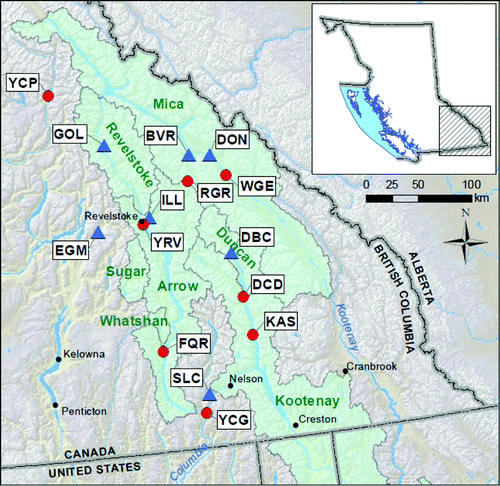
Stream discharge data from seven Water Survey of Canada (WSC) gauges were analyzed in this study ( and ). Because the gauges are located either within or in close proximity to BC Hydro basins, the streamflow data were thought to be generally representative of reservoir inflow data. The stream gauges are located in the headwaters and are representative of natural flows (two of them are Reference Hydrometric Basin Network stations). Daily discharge data were converted to monthly mean flows and reorganized into hydrologic years spanning 1 October of one calendar year to 30 September of the next calendar year. Data range varies by watershed. The Slocan River (1930–2008) has the longest available record whereas Beaver River (1986–2008) has the shortest record.
Table 1. Summary of stream gauging and climate stations used in the study. The station ID refers to the Water Survey of Canada hydrometric station ID (letter and numeric identifier) or the Meteorological Service of Canada climate station ID (numeric identifier) as applicable.
Fig. 1 Location map of hydrometric stations (blue triangles; WSC) and climate stations (red circles; MSC) used in this study. The outlines show BC Hydro watershed boundaries. The three-letter station codes are defined in .
The data were analyzed using two different techniques: one was a composite analysis with Monte Carlo significance testing and the other was a correlation analysis. Data pre-processing varied slightly between the analysis techniques.
The objective of composite analysis, as applied here, was (i) to determine, in a graphically compelling manner, how the three (i.e., positive, neutral, and negative) climate states of a particular climate mode affect the monthly values of the hydroclimatic variable analyzed, and (ii) whether any deviation from the average is statistically significant. An advantage of composite analysis with a Monte Carlo resampling test for significance is that it makes no distributional assumptions and is robust to non-linearity. Similar methods have been employed with success in several previous teleconnection studies (e.g., Fleming et al., Citation2007; Gershunov, Citation1998; Gobena & Gan, Citation2006; Ntale & Gan, Citation2004; Piechota & Dracup, Citation1996). Statistical significance of the conditional composites was determined by a two-sided bootstrap test whereby 10,000 synthetic composites were generated by resampling with replacement from the original data. If the conditional composite fell outside the 5th and 95th non-exceedance percentiles of the resulting synthetic ensemble, the hydroclimatic response to the climate state was deemed statistically significant.
Daily streamflow, precipitation, and temperature data were aggregated to monthly values to identify the seasonal pattern of the hydrologic response to each climate mode. Record lengths used in the analysis are station specific. They are listed in . The composites were computed as averages—conditioned on three distinct climate states (i.e., above-, near-, and below-average climate index values). For example, for ENSO, streamflow data were conditioned on El Niño, La Niña, and ENSO neutral conditions. The ENSO states were defined using the Nino3.4 index, a 3-month rolling average window and thresholds of ±0.75 standard deviations for five consecutive three-month periods. State definitions for extratropical climate modes (i.e., PDO, NPGO, PNA, and AO) were based on their wintertime indices, because teleconnections in the extratropics are generally viewed to have the largest variability during the cold season (e.g., Thompson & Wallace, Citation2000; Wallace & Gutzler, Citation1981). Specifically, PDO and NPGO states were defined using the November–March index and thresholds of ±0.75 standard deviations. The PNA and AO states were defined using December–February and January–March averages, respectively, and thresholds of ±0.5 standard deviations. The aggregation windows used follow existing literature (e.g., see Mantua, Hare, Zhang, Wallace, & Francis, Citation1997; Thompson & Wallace, Citation2000; Wallace & Gutzler, Citation1981) and, therefore, differed among the climate modes.
The second method used was a correlation analysis. Its objective was to extract those climate indices and index aggregation periods that are most highly associated with water supply availability. Those would then be the most promising candidates for predictor variables in empirical water supply forecast modelling. Specifically, Spearman's correlation was applied here. It is based on the rank of the data in the historical record rather than the data values. In that sense, the rank correlation coefficient is a nonparametric measure of monotonic association between the climate signal and the response (i.e., streamflow). Because it is a distribution-free alternative to Pearson's correlation analysis, it is robust to non-normality, heteroscedasticity, and monotonic non-linearity. The calculation of the significance of the correlation was based on the standard Student's t-test. Spearman rank correlations between climate indices and streamflow were computed for two-, three-, and four-month climate index aggregation periods. Monthly, February–September and June–August average streamflow, and various signal arrival times were considered in the analysis. Note that the February–September period is the primary water supply forecast window used at BC Hydro. Signal arrival time is defined here as the date when correlations become significant at the 5% level for the first time. It is assumed that a significant correlation is indicative of the climate signal's potential for water supply forecasting.
A total of 11 climate indices, namely, the Niño1+2, Niño3, Niño3.4, Niño4, Multivariate ENSO index (MEI), Southern Oscillation Index (SOI), PDO, PNA, AO, NPGO, and NPO were included in the rank correlation analysis. Definitions of these indices and the data sources used in the study are given in . Because of index data availability constraints, correlations were computed for the 1951–2008 period or the streamflow record period, whichever was shorter.
Table 2. List of climate indices used in the study and their sources.
The utility of the results in the context of water supply forecasting was also demonstrated through evaluation of early season forecasts for the Slocan River based on the principal components regression (PCR) technique. The PCR technique is a variant of linear regression that is more suitable than conventional multiple linear regression for modelling a response variable with predictors that are highly correlated or even collinear. Principal components analysis transforms a set of correlated variables into an equal number of uncorrelated variables called principal components, with the hope that most of the variance in the original predictors will be explained by the first few components. Conversely, only the first few principal components may be retained for regression with the response variable. For uncorrelated predictors, PCR reduces to the conventional multiple linear regression. A full description of PCR can be found in Garen (Citation1992).
3 Results
a Hydroclimatic variability
An example of the streamflow composite analysis results is shown in for the Slocan River at Crescent Valley. Results for all seven streamflow gauging stations and the five climate modes are summarized in .
Table 3. Streamflow responses to the opposite phases of five large-scale climate modes expressed as the direction of change with respect to the period-of-record average discharge: ppp (nnn) indicates an increase (decrease) by more than 10%; pp (nn) indicates an increase (decrease) by 5 to 10%; p (n) indicates an increase (decrease) by 2.5 to 5%; o indicates a near-average response (i.e., within –2.5 to 2.5%). Bold font denotes months during which the streamflow response is statistically significant. A minimum of five events was required to generate a composite. The three-letter hydrometric station codes are defined in .
Fig. 2 Month-by-month composites of streamflow conditional on ENSO, PDO, PNA, NPGO, and AO states for the Slocan River at Crescent Valley based on data from 1930 to 2008. The thick solid blue line is the average flow conditional on La Niña, cool PDO, negative PNA, negative NPGO, or negative AO phases as applicable; the thick red dashed-dotted line is the average flow conditional on El Niño, warm PDO, positive PNA, positive NPGO, or positive AO phases as applicable; the thin black broken line is the neutral phase average flow; n is the number of episodes used to generate each composite; months with statistically significant streamflow response and its direction relative to the long-term average are shown with markers.
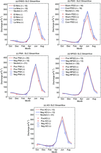
In all the streamflow records analyzed, the ENSO and PDO states are discernible in three distinct periods of the year. El Niño and warm PDO phases each tend to be associated with below-average river flows from November to January or February, above-average flows from March to April, and below-average flows from May or June to August or September. Conversely, both La Niña and cool PDO phases tend to be associated with above-average, below-average, and above-average flows, respectively, during those three periods of the water year. These patterns are consistent with those identified for snowmelt-dominated flow regimes in other parts of the province (Fleming et al., Citation2007; Rodenhuis et al., Citation2007). The exact length of the response periods varies depending on which climate mode and/or climate phase is considered (see ).
The explanation for the streamflow behaviour can be gleaned from climate data. The warm (cool) phases of ENSO and the PDO have been associated with an increase (decrease) in winter/spring temperature and a decrease (increase) in winter/spring precipitation in southeast British Columbia (e.g., see Fleming & Whitfield, Citation2010). Thus, the seasonal patterns identified in river flows are consistent with the modulating effect of the climate modes on terrestrial climate. In the fall/winter period, their impact on streamflow is likely manifested through reduced or enhanced contributions of rainfall runoff to river flows, depending on the particular climate phase considered. The early spring response is likely due to the role of temperature anomalies associated with these climate modes, which could advance or delay the onset of low elevation snowmelt and/or affect rainfall to snowfall proportions. During the summer season, streamflow response in nival/nivoglacial regimes is in large part a function of accumulated snowpack, which has also been associated with large-scale climate modes (e.g., see Hsieh & Tang, Citation2001).
Our results confirm that response asymmetry is a common trait of teleconnections (Hoerling, Kumar, & Zhong, Citation1997). Where significant streamflow responses exist during the May–September period, those conditional on El Niño and a warm PDO are of longer duration than those conditional on La Niña and a cool PDO. In particular, statistically significant responses to El Niño and a warm PDO are also seen beyond August, whereas those associated with La Niña and a cool PDO are confined to shorter periods (specifically, July–August for La Niña and May and August for a cool PDO). The comparative scarcity of statistically significant associations during cool phases of these climate modes, despite offering some contrast to their warm counterparts, suggests that there are more event-to-event variations in the streamflow response to cool phases than in the response to warm phases.
Streamflow anomalies associated with the PNA pattern are somewhat similar to those associated with ENSO and the PDO. Just like El Niño and a warm PDO, positive PNA is associated with a tendency for decreased flows between November and February, increased flows between March and April, and decreased flows between June and September. This is consistent with a positive PNA being associated with significantly warmer winter temperatures (December–March) and reduced winter precipitation (particularly, December; results not shown). On the contrary, although winter (December–March) temperatures during a negative PNA are significantly cooler, and although there is a tendency for increased precipitation during winter (significantly so in January), the streamflow response is not significantly different from the long-term average. Again, it is important to note that (i) the PNA effects are highly asymmetric, and (ii) there is little consistency in the streamflow response to a negative PNA.
Streamflow responses to positive and negative phases of the AO are also highly asymmetric—AO effects can only be detected for negative index conditions. Responses are primarily evident from January to March and June to September, when the AO's negative phase is associated with significantly reduced flows relative to the long-term average for most watersheds. Although the length of the response period varies from station to station, a negative AO is associated with cooler than average temperatures during the months of December, January, and March (results not shown). A negative AO is also generally associated with below-average precipitation during winter and spring, but responses in the northern portion of the study area are weaker than those to the south. Statistically significant precipitation responses are mainly observed between March and May. Reduced summer flows can thus be attributed to below-average snowpack accumulation. Below-average flows between January and March could be a result of a reduction in rain-on-snow events and/or river ice formation resulting from cooler than average temperatures.
Among the climate patterns considered, the NPGO exerts the least overall impact on streamflow variability in this region. The most regionally coherent response to the NPGO occurs in the month of May, when five of the seven stations analyzed show significantly increased flows associated with its negative phase. For the same month and NPGO phase, temperatures are significantly warmer than average at several stations across the region whereas precipitation responses are not significant (results not shown). Hence, above-average May flows are likely a result of more intense than average snowmelt contribution during its negative phase.
b Implications for water supply forecasting
The evolution of correlations between climate indices and February–September flow for four of the seven stations are illustrated in . Indices with the two best correlations to the February–September flow—and for the various signal arrival times—are also compiled in for all seven stations.
Table 4. Top two ranked climate indices in terms of rank correlations to the February–September streamflow volume, for each three-month index aggregation period. Correlations are shown in parentheses. Indices with correlations significant at the 1% level are shown in bold font; those significant at the 5% level are italicized; those that are not significant at the 5% level are in regular font. The three-letter hydrometric station codes are defined in . The data ranges used for the correlation analyses are the shorter of water years 1951–2008 and the periods given in .
Fig. 3 Evolution of rank correlations between February–September flow and climate indices aggregated over a three-month window for select basins. The three-letter hydrometric station codes are defined in . Absolute correlations are shown for ease of comparison. The solid and dashed horizontal lines indicate the 5% and 1% significance levels. The data ranges used for the correlation analyses are the shorter of water years 1951–2008 and the periods given in .
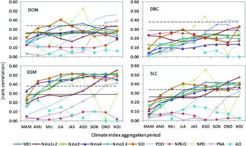
From and , it can be seen that for one watershed, an ENSO index becomes available as early as June of the year prior to the hydrologic year of the forecast period; for several watersheds ENSO indices become available in July. However, at this point in time the statistical relationships are relatively weak. This means, though, that for most of the watersheds analyzed, it might be possible to develop forecast models for a forecast date as early as 1 July. Note that Beaver River, which has the shortest record among the gauges analyzed, does not show significant correlations with any of the indices for the February–September target (). However, significant correlations with ENSO, the PDO, the NPGO, and the NPO indices for other target periods (e.g., June–August streamflow) have been observed for this gauge (results not shown).
From the October index arrival time onwards, North Pacific climate indices, particularly the PDO and NPO, show competitive, if not marginally better, correlations with the target than ENSO indices. The exception to this observation is Eagle River near Malakwa (EGM), where the overall top two correlations are all with ENSO indices. For the October and November index arrival times, the NPO index appears as the signal with the best correlations to the February–September streamflow volume at over half of the stations (). This can, at least in part, be explained by the significantly positive correlation between accumulated October–February precipitation and the June–October NPO index, as detected at several climate stations in the Columbia River basin (see ).
Table 5. Rank correlations between three-month average NPO index and October–February accumulated precipitation for select stations in the Upper Columbia basin. Correlations significant at the 1% level are shown in bold font; those significant at the 5% level are italicized. Correlations not significant at the 5% level are in regular font. The analysis was based on 1960–2008 water year data. The three-letter climate station codes are defined in .
The data clearly show that different climate indices work best at different times of the year. This suggests that it will be beneficial to incorporate those climate indices as predictor variables into empirical forecast models that provide the most skilful forecasts. Conventionally different empirical models are constructed for each forecast date, and water supply forecasts are normally issued once per month near the start of every month. Practically, this might mean, for example, that models for forecast dates prior to October use ENSO indices as predictor variables whereas models for October and later forecast dates use PDO or NPO indices. This is an important finding, because it is common practice to keep hydroclimatic predictor variables constant throughout hydrologic periods, if not the entire forecast season. The reason for this practice is to avoid fluctuations in subsequent forecasts that are a result of sampling variability rather than truly changed conditions.
The current generation of statistical water supply forecast models at BC Hydro was developed using the principal components regression technique (Garen, Citation1992). To test if the incorporation of relatively new climate indices into these models can improve forecast skill or not, equations for early season (i.e., 1 November and 1 December) forecast issue dates for the Slocan River were redeveloped using the same technique. Of the data analyzed in this study, the Slocan River location is the only forecast point for which operational water supply forecast equations readily exist. Candidate predictor variables for the operational model included October precipitation (Oct. P), winter precipitation (WP; cumulative 1 November to current date precipitation), winter conditional precipitation (WCP; cumulative 1 November to current date precipitation that occurred on days when daily maximum temperatures remained below 2°C), antecedent flows (Q), and an ENSO climate index (MEI or SOI) averaged over the June–September window. For the model derived in this study, North Pacific climate indices averaged over the June–September window were also added to the pool of candidate predictors. The predictand is the water supply volume for the upcoming February–September period. To make a fair comparison, the number of principal components retained for regression was set to be the same as those used in the operational models. Both models were evaluated in a leave-one-out (or jackknife) hindcast mode for the 1966–2002 period, which was the period used for the operational model development.
Forecasts were evaluated in terms of a standard error skill score (SS), which is defined as SS = 100(1 − SE f /SEclim), where SE f is the standard error of the jackknife forecast, and SEclim is the standard error of a jackknife climatological forecast. shows a comparison of jackknife cross-validation standard error skill scores for the 1 November and 1 December forecast dates. The results show that, all other things being equal, the findings from the correlation analysis can be readily used to further improve water supply models. The addition of the NPO index provided a marginal improvement (about 6%) in the standard error skill score for forecasts issued on 1 November and 1 December.
Table 6. A comparison of jackknife cross-validation standard error skill scores for early season forecasts of the Slocan River near Crescent Valley.
also shows the jackknife cross validation skill score for a 1 October model developed in this study. Forecasts using climate indices up to the end of September alone offer a 23% improvement over a naive climatological forecast, suggesting that an increase in the lead time for the water supply forecast is feasible. The operational forecast system begins in November; hence, no comparison is available for the October forecast produced in this study.
4 Discussion
The primary utility of large-scale climate information in water supply forecasting in the Canadian Columbia River region is during early season forecast issue dates (i.e., when snowpack information is not readily available). This study shows that incorporation of climate information in early season forecast equations can improve predictive skill. However, implementation of climate information in operational forecasting is constrained not only by technical improvement but also by timely availability of the information. Some climate indices (e.g., ENSO) are regularly updated by national agencies such as the National Oceanic and Atmospheric Administration (NOAA) Climate Prediction Center and the Australian Bureau of Meteorology and are useful for operational forecasting, whereas others (e.g., the PDO and NPO) are maintained by researchers and are only updated occasionally and cannot be relied upon in operational forecasting. To avoid being dependent on third-party climate data, it is possible to calculate custom climate indices from readily available gridded climate data.
It has been shown that the coexistence of two or more climate modes could enhance or weaken hydroclimatic responses depending on whether the modes are in-phase or out-of-phase (e.g., see Bonsal et al., Citation2001; Fleming & Whitfield, Citation2010; Gobena & Gan, Citation2006; Gan et al., Citation2007). By the same token, non-linear associations between climate indices may exist (e.g., Wu & Hsieh, Citation2004). The composite and correlation analysis did not explicitly investigate the combined impacts of multiple climate forcings on the hydroclimatology of the Canadian Columbia River basin. In contrast, the predictor selection routine for the regression model implicitly accounted for linear interaction.
If strong enough, non-linear relationships between the climate modes and/or their terrestrial hydrologic impacts have important ramifications for the optimal selection of analytical and predictive methods. Transformation of the predictand using natural logarithm, square root, or cubic root functions was attempted in this study but did not lead to an obvious improvement in forecast skill.
A recent study by Weng, Ashok, Behera, Rao, and Yamagata (Citation2007) has identified an emerging tropical Pacific SST warming (called “El Niño Modoki”) that is believed to be different from the conventional El Niño: the latter is characterized by eastern Pacific warming whereas the El Niño Modoki is characterized by central Pacific warming. Weng et al. (2007) and Weng, Behera & Yamagata (Citation2009) show that western US terrestrial climate anomalies are affected differently by the two El Niño types. Thus, it appears that the conventional Niño3.4-based classification of historical ENSO events (followed by the NOAA Climate Prediction Center and also used in this study) cannot distinguish between the two El Niño types. According to Di Lorenzo et al. (Citation2010), the central Pacific SST warming may be driving decadal variations in the NPGO through teleconnections involving the NPO. Hence, the relative roles of the two El Niño types on western Canada's terrestrial climate, and possible linkages between central Pacific SST variability and the Columbia basin's fall precipitation through the NPO, are topics worth exploring in the future in order to advance our understanding of the source of land surface climate variability in the basin, potentially with implications to forming next-generation water supply forecast models.
5 Summary and conclusions
This study shows that, in the Canadian Columbia River basin, local hydrologic responses to large-scale climate variability modes manifest themselves not only through changes in annual flow volumes but also through changes in seasonal flow patterns. For instance, El Niño (La Niña) events could be associated with below-average (above-average) flows in the fall/early winter, above-average (below-average) flows in early spring, and below-average (above-average) flows in the summer. Although our primary interest here lies with assessing their impact on the major water production period (i.e., the spring freshet season), knowledge of the seasonal runoff pattern could have implications for other water resources management applications, such as run-of-the-river hydropower generation and in-stream flow needs.
Broadly speaking, hydrologic response asymmetry seems to be the norm rather than the exception. Although the opposite phases of ENSO and PDO are related to correspondingly contrasting streamflow anomalies, the impacts of their warm phases is more consistent than those of their cold phases in the Canadian Columbia River basin. Similarly, only one phase of the PNA and AO consistently exerts a statistically significant impact on streamflow.
It is shown that climate indices portraying useful information about the upcoming water supply forecast season could become available as early as June of the preceding water year. Not surprisingly, ENSO indices are by far the best predictor candidates early on (until September), and are then equalled or overtaken by the North Pacific indices (particularly the PDO, NPO, and PNA). The NPGO and AO indices are not significantly correlated to the management-period water supply volume, but they could be informative for certain months; for instance, the NPGO is significantly correlated to flows for the month of May. The incorporation of select climate indices in the current generation of statistical water supply forecast models for the Slocan River showed that further reduction in early season prediction error is feasible. Apart from their utility in early season forecasts, the ability of climate indices to capture changes in spring snowmelt onset may be operationally important from an integrated water and energy management perspective.
Acknowledgements
The authors thank David Garen for supplying the principal components regression program and Scott Weston for providing geographical information system support. Stephen Déry and three anonymous reviewers provided constructive comments.
Related Research Data
References
- Barnston , A. G. and Livezey , R. E. 1987 . Classification, seasonality and persistence of low-frequency atmospheric circulation patterns . Monthly Weather Review , 15 : 1083 – 1126 . (doi:10.1175/1520-0493(1987)115<1083:CSAPOL>2.0.CO;2)
- Bond , N. A. , Overland , J. E. , Spillane , M. and Stabeno , P. 2003 . Recent shifts in the state of the North Pacific . Geophysical Research Letters , 30 : 2183 doi:10.1029/2003GL018597 (doi:10.1029/2003GL018597)
- Bonsal , B. R. , Shabbar , A. and Higuchi , K. 2001 . Impacts of low frequency variability modes on Canadian winter temperature . International Journal of Climatology , 21 : 95 – 108 . (doi:10.1002/joc.590)
- Di Lorenzo , E. , Cobb , K. M. , Furtado , J. C. , Schneider , N. , Anderson , B. T. , Bracco , A. , Alexander , M. A. and Vimont , D. J. 2010 . Central Pacific El Niño and decadal climate change in the North Pacific Ocean . Nature Geoscience , 3 : 762 – 765 . doi:10.1038/ngeo984 (doi:10.1038/ngeo984)
- Di Lorenzo , E. , Schneider , N. , Cobb , K. M. , Franks , P. J. S. , Chhak , K. , Miller , A. J. , Mcwilliams , J. , Bograd , S. J. , Arango , H. , Curchitser , E. , Powell , T. M. and Rivière , P. 2008 . North Pacific Gyre Oscillation links ocean climate and ecosystem change . Geophysical Research Letters , 35 : L08607 doi:10.1029/2007GL032838 (doi:10.1029/2007GL032838)
- Fleming , S. W. , Moore , R. D. and Clarke , G. K. C. 2006 . Glacier-mediated streamflow teleconnections to the Arctic Oscillation . International Journal of Climatology , 26 : 619 – 636 . (doi:10.1002/joc.1273)
- Fleming , S. W. and Whitfield , P. H. 2010 . Spatiotemporal mapping of ENSO and PDO surface meteorological signals in British Columbia, Yukon, and southeast Alaska . Atmosphere-Ocean , 48 : 122 – 131 . (doi:10.3137/AO1107.2010)
- Fleming , S. W. , Whitfield , P. H. , Moore , R. D. and Quilty , E. J. 2007 . Regime-dependent streamflow sensitivities to Pacific climate modes across the Georgia–Puget transboundary ecoregion . Hydrological Processes , 21 : 3264 – 3287 . (doi:10.1002/hyp.6544)
- Gan , T. Y. , Gobena , A. K. and Wang , Q. 2007 . Precipitation of southwestern Canada: Wavelet, scaling, multifractal analysis, and teleconnection to climate anomalies . Journal of Geophysical Research , 112 : D10110 doi:10.1029/2006JD007157 (doi:10.1029/2006JD007157)
- Garen , D. C. 1992 . Improved techniques in regression-based streamflow volume forecasting . Journal of Water Resources Planning and Management, ASCE , 118 : 654 – 670 . (doi:10.1061/(ASCE)0733-9496(1992)118:6(654))
- Gershunov , A. 1998 . ENSO influence on intraseasonal extreme rainfall and temperature frequencies in the contiguous United States: Implications for long-range predictability . Journal of Climate , 11 : 3192 – 3203 . (doi:10.1175/1520-0442(1998)011<3192:EIOIER>2.0.CO;2)
- Gobena , A. K. and Gan , T. Y. 2006 . Low-frequency variability in southwestern Canadian stream flow: Links with large-scale climate anomalies . International Journal of Climatology , 26 : 1843 – 1869 . (doi:10.1002/joc.1336)
- Hoerling , M. P. , Kumar , A. and Zhong , M. 1997 . El Niño, La Niña, and the nonlinearity of their teleconnections . Journal of Climate , 10 : 1769 – 1786 . (doi:10.1175/1520-0442(1997)010<1769:ENOLNA>2.0.CO;2)
- Hsieh , W. W. and Tang , B. 2001 . Interannual variability of accumulated snow in the Columbia basin, British Columbia . Water Resources Research , 37 : 1753 – 1760 . (doi:10.1029/2000WR900410)
- Jay , D. A. and Naik , P. K. 2011 . Distinguishing human and climate influences on hydrological disturbance processes in the Columbia River, USA . Hydrological Sciences Journal , 56 : 1186 – 1209 . (doi:10.1080/02626667.2011.604324)
- Knox , J. L. and Lawford , R. G. 1990 . The relationship between Canadian Prairie dry and wet months and circulation anomalies in the mid-troposphere . Atmosphere-Ocean , 28 : 189 – 215 . (doi:10.1080/07055900.1990.9649374)
- Mantua , N. and Hare , S. 2002 . The Pacific Decadal Oscillation . Journal of Oceanography , 58 : 35 – 44 . (doi:10.1023/A:1015820616384)
- Mantua , N. J. , Hare , S. R. , Zhang , Y. , Wallace , J. M. and Francis , R. C. 1997 . A Pacific interdecadal climate oscillation with impacts on salmon production . Bulletin of the American Meteorological Society , 78 : 1069 – 1079 . (doi:10.1175/1520-0477(1997)078<1069:APICOW>2.0.CO;2)
- Moore , R. D. and McKendry , I. G. 1996 . Spring snowpack anomaly patterns and winter climatic variability, British Columbia, Canada . Water Resources Research , 32 : 623 – 632 . (doi:10.1029/95WR03640)
- Ntale , H. K. and Gan , T. Y. 2004 . East African rainfall anomaly patterns in association with El Niño/Southern Oscillation . Journal of Hydrologic Engineering , 9 : 1 – 12 . (doi:10.1061/(ASCE)1084-0699(2004)9:4(257))
- Piechota , T. C. and Dracup , J. A. 1996 . Drought and regional hydrologic variation in the United States: Associations with El Niño/Southern Oscillation . Water Resources Research , 32 : 1359 – 1373 . (doi:10.1029/96WR00353)
- Rodenhuis , D. , Bennett , K. E. , Werner , A. T. , Murdock , T. Q. and Bronaugh , D. 2007 . Climate overview 2007 , Victoria , , BC, Canada : Pacific Climate Impacts Consortium .
- Shabbar , A. , Bonsal , B. and Khandekar , M. 1997 . Canadian precipitation patterns associated with the Southern Oscillation . Journal of Climate , 10 : 3016 – 3027 . (doi:10.1175/1520-0442(1997)010<3016:CPPAWT>2.0.CO;2)
- Shabbar , A. and Khandekar , M. 1996 . The impact of El Niño-Southern Oscillation on the temperature field over Canada . Atmosphere-Ocean , 34 : 402 – 416 . (doi:10.1080/07055900.1996.9649570)
- Stahl , K. , Moore , R. D. and McKendry , I. G. 2006 . The role of synoptic circulation in the linkage between large-scale ocean-atmosphere indices and winter surface climate in British Columbia, Canada . International Journal of Climatology , 26 : 541 – 560 . (doi:10.1002/joc.1268)
- Thompson , D. W. J. and Wallace , J. M. 2000 . Annular modes in the extratropical circulation. Part I: Month-to-month variability . Journal of Climate , 13 : 1000 – 1016 . (doi:10.1175/1520-0442(2000)013<1000:AMITEC>2.0.CO;2)
- Wallace , J. M. and Gutzler , D. S. 1981 . Teleconnections in the geopotential height field during the northern hemisphere winter . Monthly Weather Review , 109 : 784 – 812 . (doi:10.1175/1520-0493(1981)109<0784:TITGHF>2.0.CO;2)
- Weng , H. , Behera , S. K. and Yamagata , T. 2009 . Anomalous winter climate conditions in the Pacific Rim during recent El Niño Modoki and El Niño events . Climate Dynamics , 32 : 663 – 674 . doi:10.1007/s00382-008-0394-6 (doi:10.1007/s00382-008-0394-6)
- Weng , H. Y. , Ashok , K. , Behera , S. , Rao , A. S. and Yamagata , T. 2007 . Impacts of recent El Niño Modoki on dry/wet conditions in the Pacific Rim during boreal summer . Climate Dynamics , 29 : 113 – 129 . doi:10.1007/s00382–007-0234-0 (doi:10.1007/s00382-007-0234-0)
- Woo , M. and Thorne , R. 2003 . Comment on “Detection of hydrologic trends and variability” by Burn, D. H. and M. A. Hag Elnur, 2002 . Journal of Hydrology , 277 : 150 – 160 . (doi:10.1016/S0022-1694(03)00079-9)
- Wu , A. and Hsieh , W. W. 2004 . The nonlinear northern hemisphere winter atmospheric response to ENSO . Geophysical Research Letters , 31 : L02203 doi:10.1029/2003GL018885 (doi:10.1029/2003GL018885)