Abstract
A mechanistic exploration of how ozone formation in the Lower Fraser Valley (LFV) has changed over a 20-year (1985–2005) retrospective period was performed using numerical models, observations, and emissions data from four key episodes selected from the 20-year period. The motivation for this study was the observed differences in trends in summertime episodic ozone concentrations recorded at various monitoring stations within the valley; stations in the western part of the valley have generally shown a noticeable reduction in episodic ozone concentrations whereas stations in the eastern part of the valley have shown little or no improvement in their maximum 8-hour averaged ozone concentrations. Concurrent with these air quality changes, there has been a well-documented reduction in ozone precursor emissions along with an observed shift in the population patterns within the valley over the 20-year period. Ozone formation for four episodes, encompassing the different meteorological regimes that occur during LFV ozone events and spanning the retrospective period, were investigated using the Weather Research and Forecasting (WRF)-Sparse Matrix Operator Kernel Emission (SMOKE)-Community Multiscale Air Quality (CMAQ) modelling system. For each episode, two simulations, intended to isolate the effects of emission changes from meteorological changes, were performed: one with emissions set at the 1985 level and the other with emissions set at the 2005 level. Based on analysis of the model output, observational data, and precursor emission inventories, we find that the Port Moody station in the western LFV remains a volatile organic compound (VOC)-sensitive location; the central part of the LFV around the town of Chilliwack has generally changed from being VOC-limited to being NOx-limited; the easternmost part of the valley around the town of Hope has been and remains NOx-limited. Furthermore, based on the observational data and numerical model output, ozone production efficiency as a function of NO has increased noticeably at Chilliwack and likely in the other eastern parts of the valley. This efficiency increase has likely offset some of the benefits resulting from local NOx emission reductions.
RÉSUMÉ [Traduit par la rédaction] Nous avons effectué une exploration mécaniste de la façon dont la formation de l'ozone dans la vallée du bas Fraser (VBF) a changé au cours d'une période rétrospective de 20 ans (1985–2005) en nous servant de modèles numériques, d'observations et de données sur les émissions pour quatre épisodes clés choisis dans la période de 20 ans. Ce sont les différences observées entre les tendances dans les concentrations épisodiques d'ozone enregistrées à certaines stations de surveillance dans la vallée qui ont motivé cette étude : les stations dans la partie ouest de la vallée ont généralement affiché une réduction notable des concentrations épisodiques d'ozone alors que les stations dans la partie est de la vallée n'ont montré que peu ou pas d'amélioration dans les valeurs maximales des concentrations moyennes d'ozone sur 8 heures. Concurremment avec ces changements dans la qualité de l'air, il s'est produit une réduction bien documentée dans les émissions de précurseurs de l'ozone en même temps qu'un déplacement observé dans les configurations de population dans la vallée au cours de la période de 20 ans. Nous avons étudié la formation d'ozone au cours de quatre épisodes, englobant les différents régimes météorologiques survenus lors des événements d'ozone dans la VBF et couvrant la période rétrospective, à l'aide du système de modélisation SMOKE (Sparse Matrix Operator Kernel Emissions) – CMAQ (Community Multiscale Air Quality) du WRF (Weather Research and Forecasting). Pour chaque épisode, nous avons effectué deux simulations visant à isoler l'effet des changements dans les émissions de l'effet des changements météorologiques, l'une avec les émissions réglées au niveau de 1985 et l'autre avec les émissions réglées au niveau de 2005. En nous basant sur l'analyse de la sortie du modèle, les données d'observation et les inventaires des émissions de précurseurs, nous trouvons que la stations de Port Moody dans l'ouest de la VBF demeure un endroit sensible aux composés organiques volatiles (COV); la partie centrale de la VBF, autour de la ville de Chilliwack, a généralement changé de « limitée par les COV » à « limitée par les NOx »; la partie la plus à l'est de la vallée, autour de la ville de Hope, était et est restée « limitée par les NOx ». De plus, d'après les données d'observation et la sortie du modèle numérique, l'efficacité de la production d'ozone en fonction de NO a notablement augmenté à Chilliwack et vraisemblablement dans les autres parties de l'est de la vallée. Cette augmentation d'efficacité a probablement annulé certains gains provenant des réductions dans les émissions locales de NOx.
1 Introduction
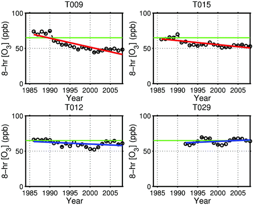
As a result of marked reductions in local precursor emissions, driven in part by local air quality management plans (Greater Vancouver Regional District, Citation1994, Citation2005), the Lower Fraser Valley (LFV), British Columbia (BC), has seen a general decrease in summertime ozone concentrations since the mid-1980s (Vingarzan & Taylor, Citation2003). However, one puzzling aspect of the changes is that the observed reductions in ozone concentrations have not been uniform across the valley. In a statistical study of observed ozone concentrations at two fixed monitoring stations between 1978 and 1990, Joe, Steyn, and Susko (Citation1996) found a statistically significant decreasing ozone trend at the Port Moody monitoring station (T09) in the western part of the LFV and an increasing trend at Abbotsford in the eastern LFV. They speculate that these differing trends have arisen because of an eastward shift in the centroid of precursors, likely a result of more rapid population growth up-valley. More recently, locations in the western part of the valley (Port Moody and Surrey) have shown statistically significant reductions of over 20 ppb in their calculated Canada Wide Standard (CWS; Canadian Council of Ministers of the Environment, Citation2000) values for ozone, (i.e., the fourth highest annual measurement of daily maxima of 8-hour running averages, averaged over three consecutive years). These reductions have led several of these stations to move from out of compliance to in compliance with the CWS threshold of 65 ppb. However, locations in the eastern part of the valley, namely Chilliwack and Hope, have shown either modest reductions (Chilliwack) or no reductions (Hope) in their reported CWS values, with present CWS values at or near the 65 ppb threshold. shows various geographic locations, monitoring stations, and communities within the LFV; because of the multitude of locations referred to in this text, please consult of Steyn, Ainslie, Reuten, and Jackson (Citation2012) for additional locations of interest within the LFV. shows time series plots of the 3-year average of the fourth highest 8-hour average ozone concentrations at Port Moody (T09), Surrey East (T15), Chilliwack (T12) and Hope (T29) between 1985 and 2005.
Fig. 1 Map of the LFV showing selected Metro Vancouver monitoring station locations (numbered triangles), urban areas of note (red), and important bodies of water and local elevation (shading).
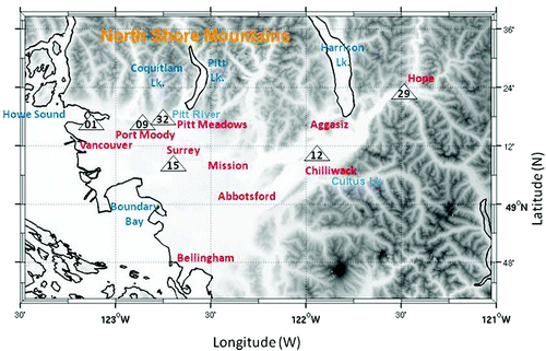
Fig. 2 Time series plots of the 3-year running average of the fourth highest 8-hour averaged ozone concentration (open circles) at T09 (Port Moody), T15 (Surrey East), T12 (Chilliwack) and T29 (Hope). The green line in each plot is the CWS of 65 ppb. Trend lines are also included. Red lines indicate statistically significant (95% level) trends whereas blue lines are not statistically significant.
The overall objective of the present analysis is to provide a mechanistic understanding of the relationship (and evolution thereof) between ambient ozone and emissions of ozone precursors in the LFV using observations, numerical models, and emission inventories. For this analysis to be credible, the model output must be evaluated by comparing it with observations to demonstrate that the results offer a fair reflection of reality. In a companion paper (Steyn et al., Citation2012), an extensive evaluation was undertaken of an implementation of the Weather Research and Forecasting (WRF)-Sparse Matrix Operator Kernel Emission (SMOKE)-Community Multiscale Air (CMAQ) modelling framework over the LFV, demonstrating the responsiveness of the model to emissions changes (gross reductions in NOx and volatile organic compounds (VOC)), and spatial and temporal changes in emission patterns that have occurred in the past. The authors modelled four ozone episodes spanning the period (1985–2005) of large emissions reductions (VOC emissions fell from 120,492 to 72,809 tonnes and NOx emissions from 115,238 to 60,966 tonnes), which included all four characteristic local mesoscale circulation regimes common during ozone episodes (Ainslie & Steyn, Citation2007). Steyn et al. (Citation2012) found that the ozone fields from the four episodes analyzed (which span the 20-year retrospective period) were responsive to the estimated changes in local precursor emissions and generally were in good agreement with observations taken by the Metro Vancouver monitoring network. Some of the modelled episodes were in better agreement with observations than others, and this, in part, the authors traced back to weaknesses in the meteorological modelling. The model evaluation revealed four deficiencies: ozone was consistently overpredicted at a number of stations within the City of Vancouver; daytime NOx was consistently underpredicted within the city; the model tended to underpredict ozone concentrations at the easternmost portion of the LFV; and the model showed a slightly changing bias over time. Based on the estimated ozone sensitivities within the LFV (Pryor & Steyn, Citation1995; Steyn, Baldi, & Stephens, Citation1996), the first three shortcomings are consistent with a deficiency in NOx emissions while the last shortcoming suggests some uncertainties in the backcasting of the local emission source strengths. Finally, the model produced reactivity weighted VOC concentrations that were, on average, about 70% higher than the observed National Air Pollution Surveillance Network (NAPS) data.
Notwithstanding these uncertainties, part I of this work concluded that the modelling system (consisting of WRF/CMAQ boundary and initial conditions, temporally resolved episode-specific emissions inventories, and meteorological fields over the four episodes selected from the 20-year span of the study) was validated in the sense that it was judged to be fit for the intended purpose, which was to investigate factors underlying spatiotemporal shifts in the LFV ozone plume observed from 1985 to 2005. This investigation will be the core task of this second paper of this two-part work.
In order to investigate the reasons behind the differential changes in ozone air quality within the LFV over the past decades, we make use of the WRF-SMOKE-CMAQ model results that have been shown to successfully capture the decadal evolution of photochemical pollution in the LFV in relation to changes in emissions. Using the four evaluated episodes, which are representative of the four mesoscale circulation regimes commonly found during summertime ozone episodes (Ainslie & Steyn, Citation2007), we simulate each with emissions drawn from the 1985 and 2005 inventory years. Two sets of runs using one of the meteorological regimes is used to examine the influence of changing background ozone concentrations under summertime episodic conditions. We also perform a series of sensitivity runs in order to identify NOx- and VOC-sensitive regions. We make use of the sensitivity runs, the 1985 and 2005 emission runs along with observations, emission inventory data, and previous studies to identify causes for the relative decline in air quality in the eastern LFV. A final set of simulations is performed to examine the influence of changing emission spatial patterns (derived from the observed change in population density) versus the absolute change in precursor emission rates on modelled ozone levels. Section 2 describes each set of simulations in more detail while lists, for each set of simulations, the meteorological conditions and emission levels used along with the figure, if applicable, where the results are displayed. For all these runs, the potentially confounding influence of errors and biases in the emissions inventory has not been included. It is expected that some of these potential problems will be circumvented by focusing, where possible, on the change in ozone fields arising from the 2005 and 1985 emission levels.
Table 1. List of model simulations showing simulation purpose, type of meteorology used, emissions inventory year and levels, other simulation details as well as the figure number where the simulation results are presented. For a breakdown of annual emission rates by emission sector, please refer to the document prepared by Metro Vancouver (Citation2007).
2 WRF-SMOKE-CMAQ simulations
a 1985 and 2005 Emission Simulations
The meteorology from four past ozone events (24–26 June 2006; 10–12 August 2001; 17–19 July 1995; and 19–21 July 1985), characteristic of Types I, II, III, and IV, respectively, mesoscale circulation regimes (Ainslie & Steyn, Citation2007), were used with 1985 and 2005 emissions inventory data to create a 2 × 4 matrix of simulations. For both the 1985 and 2005 inventory years, the emission spatial surrogates and emission totals were adjusted based on historical demographic and economic data. For each of the four meteorological regimes, CMAQ was re-run at 36 and 12 km using background concentrations fixed at 2001 levels. This was done to remove any potentially confounding influence of changing background concentrations on the influence of emissions changes. A separate set of runs with changing background but fixed emission levels was performed to investigate this latter question. As with the episodes simulated in Steyn et al. (Citation2012), the 36 km domain initial and boundary conditions for ozone, CO, NO, NO2, HNO3, PAN, H2O2, CH2O and isoprene, were taken from REanalysis of the TROpospheric chemical composition (RETRO; Pozzoli et al., Citation2011) August 2001 output. These three-dimensional (3D) fields were interpolated both vertically and horizontally to the CMAQ modelling domain. Concentrations for all other species were set to their CMAQ default values. To limit the amount of computing, emission inventories in the 12 and 36 km domains were not adjusted to reflect 1985 or 2005 emissions. It was felt that this was an acceptable strategy because of the relative isolation of the LFV on the west coast of North America. Consequently, the modelling results presented herein reflect only the influence of changes in local emissions on local air quality and do not include the potential influence that emission changes outside the 4 km domain have on the LFV. Biogenic emissions were held fixed for all eight simulations in the 2 × 4 matrix of runs. Finally, all eight simulations used emissions data characteristic of mid-week (Tuesday, Wednesday, Thursday) activity patterns in order to remove any potential weekday and/or weekend effects from the modelling results.
b Background Ozone Sensitivity Runs
The 2001 meteorology was used for a set of two ozone background sensitivity runs. In these runs, the RETRO August 2001 background ozone concentrations were increased (decreased) by 10 ppb. The increased (decreased) concentrations were then used as initial and boundary conditions for CMAQ on the 36 km domain. All the other concentration fields were left at their original RETRO values or CMAQ default values. The output from these runs was then used to drive CMAQ on the 12 km domain, and its output in turn was used as boundary and initial conditions for the 4 km domain. These simulations used emissions appropriate for 2001.
c VOC/NOx Sensitivity Simulations
An additional series of four short sensitivity runs was made with the August 2001 meteorology and emissions inventory. In these runs, the first fully modelled day (11 August), preceded by a 12-hour spin-up (for a total of 36 hours), was run with 15% more and 15% less anthropogenic VOC and NOx emissions (with the VOC and NOx emission rates being varied separately). This day was characterized by relatively cool temperatures (maximum of 27.8°C at the mid-valley Abbotsford International Airport (YXX)); light (less than 3 m s−1) onshore daytime winds at the coastal Vancouver International Airport (YVR) and maximum hourly modelled ozone concentrations of 101 ppb north of the downtown Vancouver area. The 11 August 8-hour averaged (1300–1800 pst) ozone fields from the baseline and four sensitivity runs were then used to explore the region's ozone sensitivity to changing VOC and NOx emissions.
d Relative Importance of Changing Spatial Patterns and Emissions Levels on Ozone Formation
The final model runs performed were designed to test the relative importance of changing emission levels compared with the change in the spatial distribution of emission sources within the LFV on the modelled 2005–1985 differences in ozone concentrations. This was achieved with two additional runs: one with 1985 emission levels but spatial surrogates (used to distribute the emissions spatially throughout the modelling domain) appropriate for 2005; and the other with 2005 emission levels but with 1985 spatial surrogates. These runs were performed using the 2006 (Type I) meteorology. Both simulations used the same temporal allocation factors in their emissions inventory.
3 Results
a VOC/NOx Sensitivity
We used the four sensitivity runs to identify long-lived indicator species that could be useful for diagnosing ozone sensitivities (Sillman, Citation1995; Tonnesen & Dennis, Citation2000). To do this, we calculated the sensitivity of ozone to NOx
and VOCs (Δ[O3]/ΔE
VOC) as the fractional change in [O3] with respect to a percentage change in NOx and VOC emissions:
Fig. 3 The modelled percentage change in ozone concentration (dO3) to a percentage change in emissions (dE) of either VOC (blue crosses) or NOx (purple circles) as a function of the modelled ratio of [O3]/[NOy].
![Fig. 3 The modelled percentage change in ozone concentration (dO3) to a percentage change in emissions (dE) of either VOC (blue crosses) or NOx (purple circles) as a function of the modelled ratio of [O3]/[NOy].](/cms/asset/aaa89975-863e-41a2-bb21-42a25c1bb836/tato_a_782264_o_f0003g.jpg)
b Exploration Simulations
to consist of four sets of plots showing modelled maximum 8-hour average ozone concentration at each grid cell, which we refer to as the ozone exposure, on one of the three fully modelled days for each of the four mesoscale meteorological regimes using (a) 1985 emissions and (b) 2005 emissions. To help track the change in modelled ozone sensitivity to the different emission fields, the predicted VOC/NOx ridgeline (based on the [O3]/[NOy] ratio) has also been plotted. Each plot is described in more detail below.
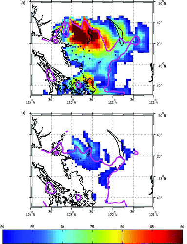
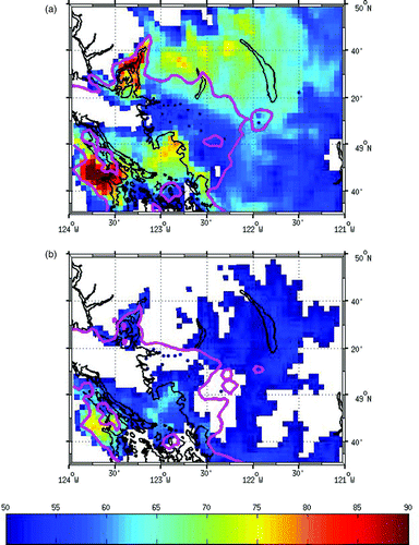
Fig. 4 Modelled maximum 8-hour average ozone exposure field (in ppb) over day 1 using Type I meteorology (24 June 2006) for (a) 1985 emissions and (b) 2005 emissions. Also shown is the predicted VOC/NOx ridgeline based on the [O3]/[NOy] ratio (magenta) and the fixed monitoring network station locations (black squares).
![Fig. 4 Modelled maximum 8-hour average ozone exposure field (in ppb) over day 1 using Type I meteorology (24 June 2006) for (a) 1985 emissions and (b) 2005 emissions. Also shown is the predicted VOC/NOx ridgeline based on the [O3]/[NOy] ratio (magenta) and the fixed monitoring network station locations (black squares).](/cms/asset/08208387-d42c-4521-a454-010f69f6a67e/tato_a_782264_o_f0004g.jpg)
1 Type I simulations (June 2006 meteorology)
On the first day of the Type I simulations (i.e., 24 June 2006 meteorology), the 1985 emission-based ozone exposure footprint caused 8-hour exposures above 60 ppb in almost the entire valley between Langley and Hope; large areas around Chilliwack, Agassiz and the Cultus Lake area (see for locations) reached exposures above 75 ppb (a). Using 2005 emissions levels, no regions above 60 ppb are predicted (b). Within the valley, between 1985 and 2005, the VOC-NOx boundary (as indicated by the ridgeline) between Chilliwack and Abbotsford is modelled to shift westward to near the Mission area. This boundary also moves down from the ridges along the North Shore Mountains to almost the valley floor and retreats down the Pitt River Valley to the Pitt Meadows area (see for place names). Chilliwack (T12) switches from VOC sensitive under 1985 emissions to NOx sensitive under 2005 emissions. Hope (T29) is NOx sensitive for both emission scenarios, and Port Moody (i.e., T09) is always VOC sensitive.
2 Type II simulations (August 2001 meteorology)
On the second modelled day (a), the 1985-based footprint of exposures greater than 60 ppb covers the entire LFV, most of Harrison Lake, much of the North Shore Mountains and parts of the Gulf Islands. Under the 2005 emissions (b), only the southeastern edges of the LFV and along the North Shore Mountains have exposures greater than 60 ppb; high concentrations are seen only in and around the Pitt River and the Coquitlam Lake areas (see for locations). Between the two time frames, peak 8-hour average exposures drop by up to 25 ppb. Interestingly, the VOC-NOx boundary shows little east–west displacement, but it shows a large north–south retreat over the North Shore Mountains. On this day, the easternmost station at Hope (T29) changes from VOC sensitive to NOx sensitive, but the remaining stations show VOC-sensitive conditions for both emission scenarios.
Fig. 5 As in but valid for day 2 using Type II meteorology (11 August 2001).
3 Type III simulations (July 1995 meteorology)
On the second Type III day, the 1985 emissions produce high (greater than 60 ppb) ozone exposures throughout much of the eastern part of the valley and over parts of the North Shore Mountains (a). Peak concentrations exceed 80 ppb south of Chilliwack over the Cascade Mountains. Using 2005 emission levels (b), no regions are predicted to have ozone exposures greater than 60 ppb and the VOC-NOx boundary has shifted from the Mission area to around the Surrey area (within the valley) and moved down the North Shore Mountains (in the western part of the LFV).
Fig. 6 As in but valid for day 2 using Type III meteorology (18 July 1995).
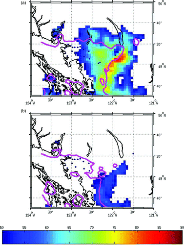
Fig. 7 As in but valid for day 2 using Type IV meteorology (20 July 1985).
4 Type IV simulations (July 1985 meteorology)
Finally, for the Type IV simulations with day-two (20 July) meteorology, the highest 1985-based exposures occur over the Howe Sound and southern Vancouver Island areas (greater than 80 ppb), over the Boundary Bay area (greater than 75 ppb), and over the North Shore Mountains (greater than 70 ppb) (a). Under 2005 emission levels (b), the Howe Sound and North Shore regions drop below 60 ppb; the Vancouver Island ozone plume is reduced in size and concentration level; and a narrow region of exposures greater than 60 ppb extends from Boundary Bay over the Strait of Georgia. Surprisingly, the VOC-NOx boundary does not change position dramatically over the Howe Sound area but does move down the North Shore Mountains and westward within the valley.
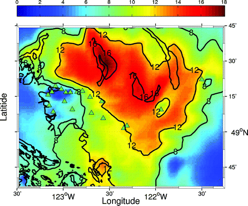
In general, the ozone ridgeline in the eastern part of the LFV appears to have moved westward during the 1985–2005 time frame, although this boundary is also strongly influenced by local meteorological circulations. A clearer picture of the evolution of ozone sensitivity can be seen when the ozone ridgelines for all twelve modelled days (four episodes each three days in length), using both the 1985 and 2005 emission inventories, are shown together (). Also included on this plot is an estimate of the mean ridgeline position using 1985 emissions (solid red line) and 2005 emissions (solid blue line). Furthermore, the estimated ridgeline positions have been plotted on top of the change in LFV population density between 2005 and 1985. This figure reveals that, in general, the ridgeline moved from the Agassiz area to west of Abbotsford (also see for locations). In the western part of the LFV, the ridgeline moved south, from the top of the North Shore Mountains to the edge of the urban areas. It also moved south down Pitt Lake to the lake entrance. In the southeastern part of the LFV, along the Cascade Mountains, the ridgeline appears to have shifted northwest from the mountain ridges into the valley.
Fig. 8 The predicted VOC/NOx ridgeline based on the [O3]/[NOy] = 7 ratio for all twelve modelled days (four episodes of three days each) using 1985 emissions (red dots) and for all days using 2005 emissions (blue dots). The solid red (blue) line gives the approximate mean position of the 1985 (2005) ridgeline. Also shown are the fixed monitoring network station locations (black squares). For clarity, the ridgelines were truncated west of Vancouver. The coloured areas show the percentage difference in the LFV population density between 2005 and 1985. The blue areas show grid cells whose population density (percentage of total LFV residing in that grid cell) have declined, and the red areas show grid cells whose percentage of the total LFV population have increased.
![Fig. 8 The predicted VOC/NOx ridgeline based on the [O3]/[NOy] = 7 ratio for all twelve modelled days (four episodes of three days each) using 1985 emissions (red dots) and for all days using 2005 emissions (blue dots). The solid red (blue) line gives the approximate mean position of the 1985 (2005) ridgeline. Also shown are the fixed monitoring network station locations (black squares). For clarity, the ridgelines were truncated west of Vancouver. The coloured areas show the percentage difference in the LFV population density between 2005 and 1985. The blue areas show grid cells whose population density (percentage of total LFV residing in that grid cell) have declined, and the red areas show grid cells whose percentage of the total LFV population have increased.](/cms/asset/99ae353e-bd10-4476-9cc2-32d8e40ebe84/tato_a_782264_o_f0008g.jpg)
By averaging the change in the modelled ozone exposure fields (between 1985 and 2005) over each day from each of the four exploration runs, a spatial picture of the evolution of the local ozone plume can be gained (). This figure shows that the largest decrease (more than 16 ppb) in 8-hour concentrations occurred around the Pitt Lake region and north of Mission. The region of second greatest decrease (more than 12 ppb) includes much of the North Shore Mountains, parts of Harrison Lake, and much of the eastern part of the valley from Abbotsford to just west of Hope. There is a notable void in the 12 ppb contour around Chilliwack. Locations near the downtown core see only a modest decrease (less than 8 ppb) while the locations further east, including Port Moody, Pitt Meadows, and Surrey show decreases between 8 and 12 ppb (see for locations). Although the magnitude of the decreases in concentration averaged over 8 hours is reasonable, the spatial pattern does not quite agree with the observed CWS trends. For example, the 12 ppb boundary should include the Port Moody (T09) area and probably not extend into Abbotsford and the eastern part of the valley (because these locations have not shown such a large change in the CWS values). One reason for the modelled spatial distribution of the response of 8-hour averaged ozone concentrations to long-term changes in precursor emissions not being entirely consistent with the observed CWS trends could be the averaging procedure. As the modelling has shown, the ozone plume is sensitive to meteorological conditions, and to be consistent with the observational record, the averaging used to create this long-term composite should have weighted each day by the frequency of occurrence of the mesoscale meteorology for that day. Alternatively, it could also be the case that the model runs need to be conducted over a longer period to be comparable to the observational record.
Fig. 9 Spatial plot of the average decrease (in ppb) between 1985 and 2005 in the modelled 8-hour averaged ozone exposure. The 8-hour exposure field was averaged over each of the three days in each of the four exploration runs. Also shown are the monitoring network station locations (green triangles) and contours at 8, 12, and 16 ppb (thin black lines).
c Changing Emission Spatial Patterns Versus Changing Emissions Levels Simulations
These simulations were aimed at separating the sensitivity of the modelled ozone plume to spatial shifts in emission densities (arising from changing population and economic activity within the LFV over the 20-year retrospective period) from the sensitivity of the ozone plume to the absolute change in emission rates. The spatial change in emission patterns was captured by using the relative change in local population density to adjust the emission spatial surrogates.
shows time series plots of the difference in modelled diurnal ozone concentrations (in parts per billion) at the downtown (T01), Port Moody (T09), mid-valley (T12), and eastern (T29) stations (averaged over the simulation) between the runs with 1985 emissions/1985 spatial surrogates and 2005 emissions/2005 spatial surrogates (red curves); 1985 emissions/2005 spatial surrogates and 2005 emissions/2005 spatial surrogates (blue curves); 2005 emissions/1985 spatial surrogates and 2005 emissions/2005 spatial surrogates (green curves). The red curves represent the difference in ozone concentrations arising from both emission and spatial surrogate changes, the blue curves from emissions changes only and the green curves from changing spatial surrogates only. Positive values for the blue curve represent lower ozone concentrations arising from 1985 to 2005 emissions reductions only; positive values for the green curve represent lower ozone concentrations arising from 1985 to 2005 population density changes only; positive values for the red curve represent lower ozone concentrations arising from a combination of lower emissions and changing (1985 to 2005) population densities. The differences resulting from emissions only (blue curve) and to spatial surrogate changes only (green curve) do not equal the differences resulting from changes in both (red curve) because of the non-linearity in ozone formation.
Fig. 10 Time series plots of the modelled difference in the average diurnal ozone concentrations (ppb) at T01, T09, T12, and T29 between runs with 1985 emissions/1985 spatial surrogates and 2005 emissions/2005 spatial surrogates (red curves); 1985 emissions/2005 spatial surrogates and 2005 emissions/2005 spatial surrogates (blue curves); 2005 emissions/1985 spatial surrogates and 2005 emissions/2005 spatial surrogates (green curves). Positive values for the blue curve represent lower ozone concentrations arising from 1985 to 2005 emissions reductions only; positive values for the green curve represent lower ozone concentrations arising from 1985 to 2005 population density changes only; and positive values for the red curve represent lower ozone concentrations arising from a combination of lower emissions and changing (1985 to 2005) population densities.
At the downtown T01 station, changing the spatial distribution of emissions (green line) has a small negative effect on ozone concentrations, that is, ozone concentrations are slightly higher using the 2005 spatial distribution than when using the 1985 distribution. Likely, under the 2005 distribution, while the total precursor emission rates are unchanged, they are spatially distributed over a larger area resulting in less NOx titration around the downtown core. Changing the emission levels (blue curve) also has a small negative influence, again implying ozone concentrations are generally slightly higher under 2005 emission levels, except during early afternoon (time of peak concentrations here) when the blue curve is slightly positive.
At the western Port Moody station (T09), the differences arising from changes to spatial surrogates (green line) peak in the early morning and late afternoon but are generally small (less than 5 ppb) and much less than differences resulting from emissions (blue curve). These changes are negative throughout the night until around noon when they become positive. The negative nighttime differences (i.e., higher nighttime ozone concentrations under the 2005 emission scenario) likely reflect lower nighttime NOx titration under 2005 emission levels. After noon the differences are positive and larger, and this can be attributed to the higher 1985 precursor emissions rates facilitating more ozone production. From the figure, of the maximum difference of 6 ppb (seen at 1600 local time and coincident with the time of peak concentration), 4 ppb can be attributed to changes in emissions levels and 2 ppb to changes in the spatial distribution of these emissions, although, because of the non-linearity in the system, these differences should be treated as approximations.
At the eastern Chilliwack station (T12), the effect of spatial surrogate changes is positive and generally small (green curve) until after 1600 local time, when it becomes as important as emissions changes. This effect continues to gain importance, peaking at 2000 local time which is two hours after the time of average modelled peak ozone. Until 1600 local time, almost all of the difference in ozone concentrations (red curve) can be attributed to changes in emission levels (blue curve). At the time of peak concentration, the 28 ppb difference can be divided into 18 ppb from emission changes and 10 ppb from spatial surrogate changes. Notice that the positive nature of the differences resulting from the spatial surrogate (green curve) implies that the changes in land use and population between 1985 and 2005 have resulted in decreasing ozone concentrations (with emission levels being held fixed). The only explanation we have is that under the 2005 spatial distribution, precursor emissions from the Vancouver urban area are released over a larger area with proportionately less released within those upstream areas impacting Chilliwack.
At Hope (T29), a picture similar to T12 is observed. The influence of spatial-surrogate changes is important only in the afternoon; during the day, it is essentially negligible. At the time of modelled average peak concentration (2100 local time), the reduction in ozone concentration of 21 ppb (red curve) can be partitioned into a 13 ppb reduction from emission level changes (blue) and an 8 ppb reduction from changes to the spatial distribution (green). At T29 and T12, the higher precursor emission rates under the 1985 levels (blue curves) do not influence the morning ozone concentrations to the same extent as they do at the western T09 station (where they fall by up to 10 ppb). This suggests that at T12 and T29, upwind precursor emissions influence ozone, while the local influence of changing emission rates have little direct impact on modelled ozone concentrations.
In general, modelled ozone is sensitive to both the absolute level of emissions as well as their spatial distribution. The shift from the 1985 to 2005 spatial distribution seems to allow ozone concentrations up-valley to remain higher later in the day, perhaps in response to a more diffuse upwind plume of precursors. Also, at these up-valley locations, changing emission rates have the greatest effect on afternoon ozone concentrations. These results are only for one meteorological pattern—one that is conducive to the highest ozone concentrations occurring in the eastern part of the valley. Additional runs using the other meteorological regimes need to be performed to see how robust these findings are.
d Changing Background Ozone Simulations
Generally, the effects of changing background ozone levels on maximum 8-hour ozone concentrations is uniformly felt across the LFV, with changes at most Metro Vancouver monitoring station locations being about 3.1 ppb in the 8-hour average concentration for a 10 ppb change in background ozone. The maximum change was 3.7 ppb (Port Moody (T09) in the western part of the valley) and the minimum was 2.3 ppb (Chilliwack (T12) and Hope (T29) in the eastern part of the valley). It is interesting to note that, with respect to the 2001 emissions and meteorology, T12 and T29 were the most NOx-limited stations and were the least sensitive to changing background ozone. On the other hand, the two most sensitive stations (T09 and Pitt Meadows (T32) with a 3.6 ppb increase per 10 ppb background) were both VOC-limited yet a little downwind of the Vancouver downtown core. Evidently, at Port Moody (T09), an increase in background ozone concentration leads to an increase in the radical pool; because this location is limited by the availability of radicals, this leads to a greater increase in ozone concentrations than at an NOx-limited region (like Hope (T29)) where ozone production is not limited by radical availability.
4 Evolution of ozone sensitivity at three key stations
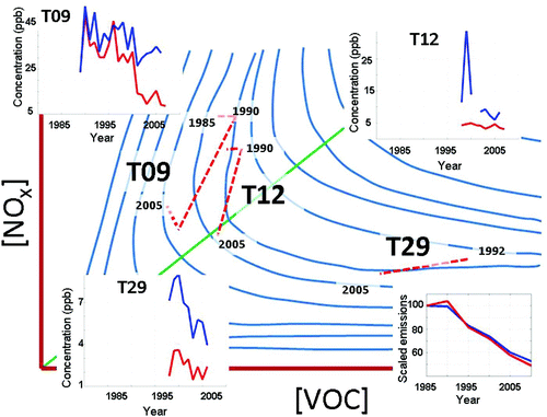
We now proceed to use the VOC sensitivity predicted by CMAQ, the yearly CWS values, and the observed ambient ozone, VOC and NOx concentrations to assemble a picture of the evolution of ozone sensitivity at three key Metro Vancouver monitoring stations in the western (T09: Port Moody), mid- (T12: Chilliwack) and eastern (T29: Hope) parts of the LFV (). In the figure, the temporal evolution of each station's ozone sensitivity has been illustrated through a piecewise linear trajectory overlaid on a generic ozone isopleth diagram. For convenience, the figure also shows each station's (T09 upper left; T12 upper right; and T29 lower left) yearly mean 8-hour average summertime (1 June–31August) VOC and NOx ambient concentrations (restricted to days on which VOC measurements were available) and a scaled time series plot of the LFV VOC and NOx emissions (lower right). shows the time series plot of each station's 8-hour CWS values.
Fig. 11 Ozone isopleth schematic showing ozone response surface (blue lines) as a function of VOC and NOx concentrations. The green line represents the ridgeline. Also shown is the time series of yearly mean 8-hour average summertime VOC (red) and NOx (blue) concentrations (restricted to days with VOC measurements) observed at T09 (upper left), T12 (upper right), and T29 (lower left). The bottom right plot shows time series plots of scaled VOC (red) and NOx (blue) emissions over the LFV. Each curve has been scaled so that its value in 1985 is equal to 100. Overlaid on the isopleth diagram is an estimate of how the ozone response to precursor emissions at T09, T12, and T29 has changed over the 1985–2005 period (dashed red lines).
a Port Moody (T09)
The CMAQ retrospective simulations suggest that ozone concentration at T09 was VOC sensitive in both 1985 and 2005, but with the ozone ridgeline migrating south towards the station over those 20 years, the sensitivity of T09 has likely moved closer to the ridgeline (). The yearly CWS values show little change between 1985 and 1990 () but show a sustained drop between 1990 and 2000. Since 2000, the CWS value has been roughly constant. The yearly mean of the summertime-observed VOC concentrations (restricted to those summer days which have both VOC and NOx measurements), shows a generally steady drop in ambient VOC concentrations from 1990 to the early 2000s with a slight decrease thereafter (red curve upper left). Finally, the observed NOx concentrations show a decreasing trend from 1990 to 2000 with a slightly increasing trend from 2000 to 2005 (blue curve upper left).
We use all of the above information (the VOC sensitivity predicted by CMAQ, the yearly CWS values and the observed ambient VOC and NOx concentrations) to piece together an estimate of how the sensitivity of T09 to precursor emissions likely changed over the 1985–2005 period ( dashed red line marked T09). We place the sensitivity of T09 in 1985 above the ridgeline with the sensitivity in 1990 located slightly to the right and lying on roughly the same isopleth as the 1985 sensitivity. This requires that ambient VOC concentrations increased only a little during this five-year period while NOx concentrations remained roughly constant. Although there are no NAPS VOC data to support this conclusion, the estimated VOC emissions from Metro Vancouver over this period show only slight increases, while the NOx emissions remain constant. We locate the sensitivity in 2000 much closer to the ridgeline (based on the CMAQ runs), to the left (in an area with lower VOCs as guided by the NAPS data), and below (in an area with lower NOx as inferred from the observed NOx concentrations) its estimated 1985 position. This transition, which crosses several isopleths, puts T09 in a region of lower ozone concentration which is consistent with the CWS trends. From 2000 to 2005, the observations suggest that T09 moved slightly away from the ridgeline (because of the observed increases in VOC and decreases in NOx concentrations); however, to be consistent with the observed unchanging CWS values, such a transition must have followed an isopleth. There is probably a lot of uncertainty in the evolution of T09′s ozone sensitivity, and the influence of varying meteorology on the idealized picture presented here would tend to make the description less straightforward.
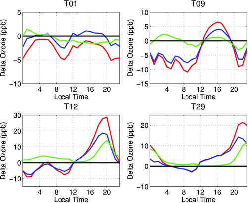
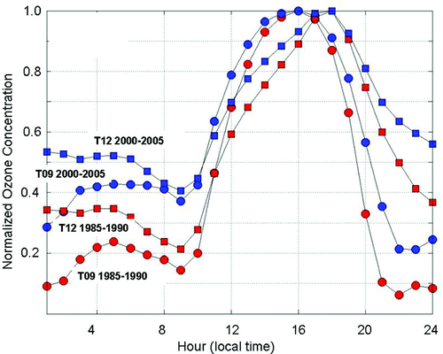
Additional insight into the evolution of T09′s ozone sensitivity can be gleaned from the observed diurnal ozone concentrations. In , average diurnal ozone concentrations at T09 from the 1985–90 (red circles) and 2000–05 (blue circles) periods is shown. The curves, derived from Metro Vancouver measurements, were calculated by finding the seven days in each year with the highest hourly ozone concentration then averaging the hourly concentrations for those days to obtain a single diurnal ozone profile for each year. Finally, the resulting six yearly profiles within each period were averaged to get single, period-averaged profiles, and each period-profile was normalized by its peak value to facilitate inter-period comparisons. This figure shows that, on average and for both periods, ozone production starts around 0900 local time with ozone concentrations reaching a maximum around 1600 local time. The observations from the 1985–90 period show a much faster growth rate during the morning and a faster decay after the daily peak than during the 2000–05 period. This temporal shift is consistent with a transition to slower chemical production, likely in response to a decrease in the reactivity (VOC/NOx ratio) of the air mass. Also evident in the figure is the incomplete nighttime titration in the 2000–05 profile which is consistent with the reduction in ambient NOx concentrations seen over the 20-year interval. Diurnal profiles at T09 based on the CMAQ simulations using 1985 and 2005 emissions and averaged over the Type I–IV simulations (not shown) reproduce the trend in the reduction of nighttime titration.
Fig. 12 Average diurnal ozone concentration profile at Port Moody (T09: circles) and Chilliwack (T12: squares) from the 1985–90 (red) and 2000–05 (blue) periods. Each curve has been normalized to highlight the temporal evolution of the diurnal profile better.
b Chilliwack (T12)
A slightly different picture is evident at T12. CMAQ modelling suggests that T12 has likely changed from VOC- to NOx-sensitive conditions (with the 2005 conditions close to the ridgeline). Again, with no VOC or NOx data between 1985 and 1990 to guide us, we used the estimated LFV emissions to place the 1985 and 1990 sensitivities close to one another (with the 1990 sensitivity being slightly to the right) and above the ridgeline ( dashed red line marked T12). Given the 1990–2000 emission changes, the shift in sensitivity predicted by CMAQ, and the almost constant observed CWS values, we infer a transition that follows an isopleth while moving towards the origin (i.e., to lower VOC and NOx concentrations) and crossing the ridgeline. It seems that little change in sensitivity occurred between 2000 and 2005. It is difficult to interpret the large spike in NOx concentration in 1998, but again with T12 being quite far downwind of the major emission sources, locally observed NOx concentrations may only be loosely correlated with the actual upwind emissions that contribute to the ozone concentrations observed at T12. Another point is that while emissions totals show decreasing VOC and NOx emissions between 2000 and 2005, these are total annual values averaged over the entire LFV. It is possible that emissions sources which affect T12 have not shown such a decrease, especially given the relative population growth in the eastern part of the valley since the 1980s ().
The evolution of the episodic diurnal ozone profile at T12 from the 1980–85 period (red squares) to the 2000–05 period (blue squares) is presented in . In general, ozone peaks at this station later than at T09 with the timing of the peak shifting from 1700 to 1800 local time over the 20-year period. The timing of morning ozone build-up has not changed noticeably, but the timing of the afternoon decline has slowed with relatively higher concentrations lingering into the late afternoon. Because of this broadening of the diurnal profile, ozone metrics based on 8-hour averaging can increase even if the peak (hourly) concentration does not.
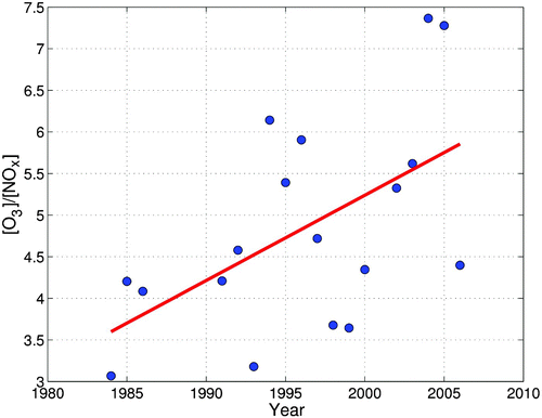
Finally, declining NOx concentrations can affect the efficiency at which ozone is produced (Reynolds, Blanchard, & Ziman, Citation2003). Ozone can be produced through the radical-assisted oxidation of NO emissions (“new” NO) or through the radical-assisted oxidation of NO recycled from photolysis (“old” NO) (Jang, Jeffries, & Tonnesen, Citation1995). Although NOx emission reductions always lower the mass of new NO available in the photochemical reactions, the number of times an NO molecule can participate in the ozone oxidation cycle typically increases as NOx emissions decrease. Thus, the mass of old NO increases and the mass of NO available to react (old + new) does not necessarily decrease with decreasing NOx emissions and can be estimated through the ratio of ambient [O3] to ambient [NOx] (Reynolds et al., Citation2003). shows a plot of mean yearly [O3]/[NOx] at T12, where the ratio for each year was calculated using ozone and NOx observations from the seven days with highest peak ozone concentration. For each day, 8-hour (1100–1800 pst) averages of NOx and ozone were calculated followed by the day's [O3]/[NOx] ratio. Also included in the figure is the linear regression through the data. The figure shows a statistically significant (at the 95% confidence level) increase in the ratio between 1984 and 2006 suggesting an increase in ozone efficiency, hence an increase in the mass of NO reacting. Although this estimate of ozone production efficiency does not take into account the effects of deposition or changing background levels, it does suggest that at T12, part of the benefits associated with NOx emission reductions has likely been offset by an increase in ozone efficiency. This effect is likely part of the reason that T12 has not experienced declining CWS values. The observational record also shows an increase, albeit it smaller, in the episodic ratio of [O3]/[NOx] at the western T09 station (not shown). This suggests that there has only been a modest increase in ozone production efficiency at T09. Using CMAQ's process analysis, we modelled the NO efficiency. Process analysis allows the model to keep track of the chemical pathways along which species react (Jeffries & Tonnesen, Citation1994). We used it to track the NOy reaction pathways in order to determine the average NO cycles (Jang et al., Citation1995) and so be able to calculate NO efficiency. Process analysis was carried out for the exploration runs using the 2006 meteorology. These results show that a 42% average increase in NO cycles occurred between 1985 and 2005 at the Metro Vancouver monitoring station locations, although there is a great deal of variability, with eastern stations generally showing larger increases than western stations. The CMAQ-based diurnal time series at T12 (not shown) reproduce the trend towards a broadening of the diurnal ozone profiles around the peak, with the broadening occurring equally before and after the peak. The CMAQ profiles also reproduce the trend towards less nighttime titration (not shown).
Fig. 13 Ratio of 8-hour average ozone to 8-hour average NOx concentrations between 1984 and 2006 (blue dots) at T12 along with the trend line (red line). Yearly values are based on 8-hour averages of the seven days with the highest hourly ozone concentrations.
c Hope (T29)
A much different picture emerges at T29. Reconstructing Hope's behaviour is more difficult because of the shorter measurement period and CMAQ's difficulty in reproducing the ozone concentrations at T29 throughout the model evaluation simulations (Steyn et al., Citation2012). Nonetheless, CMAQ suggests that T29 was and still is NOx limited (). The nearly uniform CWS trend suggests that emissions changes relevant to Hope have moved its sensitivity along an isopleth. The limited NAPS and concurrent Metro Vancouver measurements show decreasing VOC and NOx concentrations, which suggest a trajectory moving towards the origin. With the horizontal isopleth orientation in the NOx-limited region, it would appear that any reductions in ambient VOC concentrations would have had little influence on observed ozone concentrations. The lack of long-term measurement data at T29 prevents an analysis of the change in the diurnal ozone profile or the change in the ratio. The process analysis shows a modest 13% increase in NO cycles at T29 between 1985 and 2005 (not shown).
5 Discussion
In an investigation that in many ways mirrors the present one, Hedley, Jiang, McLaren, and Singleton (Citation1998) examined the effects of emission control strategies on future summertime air quality in the LFV using the 17–21 July 1985 episode. They modelled changes in ozone concentration using both a forecasted 2005 emissions inventory with a business-as-usual change in vehicle fleet composition and with an emission inventory reflecting a large shift of vehicles to natural and propane gas technologies. Hedley et al. (Citation1998) also performed two VOC- and NOx-sensitivity studies with the business-as-usual inventory. Their study, in particular the business-as-usual simulations, is relevant here for a number of reasons. Hedley et al. (Citation1998) compare the influence of 1985- and 2005-based emissions on local ozone concentrations using the same July 1985 meteorological conditions as used in the present analysis. The major difference between our research and that of Hedley et al. (Citation1998) is that we use present-day 2005 emissions and backcasted 1985 emissions while they used present-day 1985 emissions and forecasted 2005 emissions. Based on their modelling, Hedley et al. (Citation1998) estimated that in 1985, the urban Vancouver area, the mid-valley region, and parts of the North Shore Mountains were VOC limited. In addition, they show that the effects of VOC emission reductions would not be felt uniformly across the valley, with rural and suburban areas likely to experience greater reductions than urban regions. Observations show that this has not come to pass, but to be fair, the region has also been influenced by simultaneous and significant NOx reductions. They did anticipate that if NOx reductions did occur (in addition to VOC reductions), then parts of the urban plume would become NOx limited. Our study confirms many of these predictions and shows that they hold true under a wider range of meteorological conditions.
The modelled boundaries between VOC- and NOx-limited conditions are likely sensitive to the errors and biases in both the VOC and NOx emission inventories. For example, the slightly higher modelled VOC concentrations (on a reactivity weighted basis) likely place the VOC/NOx boundary too far to the east.
6 Conclusions
Based on the current modelling, and consistent with previous studies (Ainslie, Citation2004; Hedley et al., Citation1998; Jiang, Singelton, Hedley, & McLaren, Citation1997; Pottier et al., Citation2000; Pryor, Citation1998; Steyn et al., Citation1996; Suzuki, Citation1997), the western part of the valley around the T09 station has been and remains a VOC-sensitive location. It appears that the large VOC emission reductions, stemming from light-duty vehicles and petroleum refining emission controls, have been effective in reducing ozone concentrations in the western part of the valley. Part of the benefits of the reductions in VOC emissions has likely been offset by the simultaneous NOx emission reductions that have occurred in and around the Vancouver urbanized area. Nonetheless, these reductions in precursor emissions have led to decreasing 1-hour and 8-hour episodic ozone concentrations.
Mid-valley, around the city of Chilliwack (T12), it appears that the region has changed from being VOC limited to being NOx limited over the 20-year period; however, given the variability resulting from meteorology, it is probably better to characterize the station as showing mixed sensitivity. VOC reductions (largely from VOC emission reductions in light-duty vehicles, petroleum refining emissions not being greatly influential here) along with NOx emission reductions appear to have offset one another in this part of the LFV. Furthermore, ozone production efficiency as a function of NO has increased noticeably in this part of the valley. This efficiency increase has likely offset some of the benefits resulting from reductions in NOx emissions. The change in ozone sensitivity and the increased ozone production efficiency have changed the shape of the diurnal ozone profile to one that has a smaller peak around the daily maximum. As a result of this broadening, for a fixed peak ozone level, 8-hour averaged concentrations calculated around the peak concentration have increased. Finally, changes in population and economic activity over the 1985–2005 period have likely had a greater effect at mid-valley than in the western part of the valley. The net effect of these changes is consistent with the modest decline in peak 1-hour ozone concentrations (mainly since the late 1980s and early 1990s) with the weakly (and not statistically significant) declining trend in 8-hour averaged concentrations.
It is difficult to comment on the observed ozone trends at the eastern edge of the LFV (near the town of Hope) because of the shorter observational record and the difficulties that CMAQ modelling had in capturing ozone formation there. Nonetheless, it is evident that this area remains a NOx-limited region and that ozone production efficiency with respect to NO has likely increased. Such an increase would have offset some, and perhaps all, of the NOx emissions reductions achieved in the LFV. VOC emission reductions have likely had a negligible effect on ozone concentrations here. Increased growth in the eastern part of the LFV has also likely affected air quality negatively at Hope, but it is difficult to quantify this effect without better modelling capabilities in this part of the LFV.
The observed precursor emission reductions within the LFV have generally moved the ozone ridgeline boundary westward from the Agassiz–Chilliwack area to the Abbotsford–Langley area and southward from the ridges of the North Shore Mountains to the valley floor near Port Moody and Pitt Meadows. However, the ozone ridgeline is sensitive to meteorology (mainly wind direction and wind speed) and varies greatly within and between ozone episodes. For future work in this area, it would be interesting to run a simulation in which the NOx in the westward side of the domain is reduced in order to determine how much of the NOx in the NOx-limited region to the east actually originates in the west. It would also be of interest to see if the ozone in the eastern part of the valley is affected by NOx reductions in the western part of the valley.
The modelling suggests that changing background ozone concentrations have a roughly uniform influence across the LFV with slightly larger increases expected in the western parts of the LFV than in the eastern parts. Finally, the influence of errors and biases in the emissions inventories was not directly considered in the analyses, although, by examining the difference in ozone concentrations during the 1985–2005 period, it is hoped that some of these errors cancel each other. Additional model simulations would be needed to directly explore the sensitivity of the results to potential errors in the emissions inventories.
Acknowledgements
Funding for this work was provided by the Natural Sciences and Engineering Research Council (NSERC; in the form of Discovery Grants to D.G. Steyn and P.L. Jackson), with two years of support from the BC Clean Air Research fund (BC CLEAR), two years of support from the Fraser Valley Regional District, and one year of support from Metro Vancouver. Two exceptionally thorough reviews helped improve the manuscript.
References
- Ainslie , B. and Steyn , D. G. 2007 . Spatiotemporal trends in episodic ozone pollution in the Lower Fraser Valley, British Columbia, in relation to mesoscale atmospheric circulation patterns and emissions . Journal of Applied Meteorology and Climatology , 46 : 1631 – 1644 . (doi:10.1175/JAM2547.1)
- Ainslie, B. D. (2004). A photochemical model based on a scaling analysis of ozone photochemistry. (Ph.D. thesis). University of British Columbia, Vancouver, BC, Canada.
- Canadian Council of Ministers of the Environment. (June 2000). Canada-wide standards for particulate matter (PM) and ozone (Tech. rep.). Québec, QC: CCME. Retrieved from www.ccme.ca/assets/pdf/pmozone_standard_e.pdf
- Greater Vancouver Regional District. (1994). GVRD Air Quality Management Plan (Tech. rep.). Burnaby, BC: GVRD Policy and Planning Department.
- Greater Vancouver Regional District. (2005). GVRD Air Quality Management Plan (Tech. rep.). Burnaby, BC: GVRD Policy and Planning Department.
- Hedley , M. , Jiang , W. , McLaren , R. and Singleton , D. L. 1998 . Modelling of future-year emissions control scenarios for the Lower Fraser Valley: Impacts of natural gas and propane vehicle technologies . Journal of Applied Meteorology , 37 : 1190 – 1204 . (doi:10.1175/1520-0450(1998)037<1190:MOFYEC>2.0.CO;2)
- Jang , J.-C. C. , Jeffries , H. E. and Tonnesen , S. 1995 . Sensitivity of ozone to model grid resolution - II. Detailed process analysis for ozone chemistry . Atmospheric Environment , 29 : 3101 – 3114 . (doi:10.1016/1352-2310(95)00119-J)
- Jeffries , E. H. and Tonnesen , S. 1994 . A comparison of two photochemical reaction mechanisms using mass balance and process analysis . Atmospheric Environment , 28 : 2991 – 3003 . (doi:10.1016/1352-2310(94)90345-X)
- Jiang , W. , Singelton , D. L. , Hedley , M. and McLaren , R. 1997 . Sensitivity of ozone concentrations to VOC and NOx emissions in the Canadian Lower Fraser Valley . Atmospheric Environment , 31 : 627 – 638 . (doi:10.1016/S1352-2310(96)00172-0)
- Joe , H. , Steyn , D. G. and Susko , E. 1996 . Analysis of trends in tropospheric ozone in the Lower Fraser Valley, British Columbia . Atmospheric Environment , 30 : 3413 – 3421 . (doi:10.1016/1352-2310(96)00045-3)
- Metro Vancouver. (2007). 2005 Lower Fraser Valley Air Emissions Inventory & Forecast and Backcast. Retrieved from http://www.metrovancouver.org/about/publications/Publications/2005_LFV_Emissions.pdf
- Pottier , J. L. , Deuel , H. P. and Pryor , S. C. 2000 . Application of the UAM-V and use of indicator species to assess control strategies for ozone reductions in the Lower Fraser Valley of British Columbia . Environmental Monitoring and Assessment , 65 : 459 – 467 . (doi:10.1023/A:1006437414225)
- Pozzoli , L. , Janssens-Maenhout , G. , Diehl , T. , Bey , I. , Schultz , M. G. , Feichter , J. , Vignati , E. and Dentener , F. 2011 . Reanalysis of tropospheric sulphate aerosol and ozone for the period 1980–2005 using the aerosol chemistry- climate model ECHAM5-HAMMOZ . Atmospheric Chemistry and Physics Discussions , 11 : 10191 – 10263 . (doi:10.5194/acpd-11-10191-2011)
- Pryor , S. C. 1998 . A case study of emission changes and ozone responses . Atmospheric Environment , 32 : 123 – 131 . (doi:10.1016/S1352-2310(97)00324-5)
- Pryor , S. C. and Steyn , D. G. 1995 . Hebdomadal and diurnal cycles in ozone time series from the Lower Fraser Valley, B. C . Atmospheric Environment , 29 : 1007 – 1019 . (doi:10.1016/1352-2310(94)00365-R)
- Reynolds , S. D. , Blanchard , C. L. and Ziman , S. D. 2003 . Understanding the effectiveness of precursor reductions in lowering 8-hr ozone concentrations . Journal of the Air and Waste Management Association , 53 : 195 – 205 . (doi:10.1080/10473289.2003.10466143)
- Sillman , S. 1995 . The use of NOy, H2O2 and HNO3 as indicators for ozone-NOx-hydrocarbon sensitivity in urban locations . Journal of Geophysical Research , 100 : 14175 – 14188 . (doi:10.1029/94JD02953)
- Steyn , D. G. , Ainslie , B. , Reuten , C. and Jackson , P. L. 2012 . A retrospective analysis of ozone formation in the Lower Fraser Valley, B.C. Part I: Dynamical model evaluation . Atmosphere-Ocean , 51 doi:10.1080/07055900.2013.781940
- Steyn, D. G., Baldi, M., & Stephens, K. (1996). Observation based analysis of photochemical smog in the Lower Fraser Valley using two analytical schemes. (Tech. Rep. Occasional Paper no. 41). Department of Geography, The University of British Columbia, Vancouver, Canada.
- Suzuki, N. M. (1997). Application of the Urban Airshed Model in the Lower Fraser Valley, British Columbia. (Master's thesis). University of British Columbia, Vancouver, BC, Canada.
- Tonnesen , G. S. and Dennis , R. L. 2000 . Analysis of radical propagation efficiency to assess ozone sensitivity to hydrocarbons and NOx 2. Long-lived species as indicators of ozone concentration sensitivity . Journal of Geophysical Research , 105 : 9227 – 9241 . (doi:10.1029/1999JD900372)
- Vingarzan , R. and Taylor , B. 2003 . Trend analysis of ground level ozone in the greater Vancouver/Fraser Valley area of British Columbia . Atmospheric Environment , 37 : 2159 – 2171 . (doi:10.1016/S1352-2310(03)00158-4)
- Zhang , Y. , Wen , X. Y. , Wang , K. , Vijayaraghavan , K. and Jacobson , M. Z. 2009 . Probing into regional O3 and particulate matter pollution in the United States: 2. An examination of formation mechanisms through a process analysis technique and sensitivity study . Journal of Geophysical Research , 114 doi:10.1029/2009JD011900