Abstract
This study characterizes the meteorological parameters influencing glacier runoff and quantifies recent glacier contributions to streamflow in the Illecillewaet River basin, British Columbia. The Illecillewaet is a glacierized catchment that feeds the Columbia River, with terrain, glacial cover, and topographic relief that are typical of Columbia River headwaters basins in southwestern Canada. Meteorological and mass balance data collected on Illecillewaet Glacier are used to develop and constrain a distributed model for glacier melt, based on temperature and absorbed solar radiation. The melt model is applied to all of the glaciers in the Illecillewaet River basin for the summers of 2009 to 2011. Modelled glacier runoff for the three years has an average value of 112 ± 12 × 106 m3, approximately 10% of Illecillewaet River yields for 2009 to 2011. Glaciers contributed 25% to August flows for the three years. On average, 66% of modelled glacial discharge is derived from the seasonal snowpack, with the remaining 34% resulting from the melting of glacier ice and firn. For the lowest flow year in the basin, 2009, snow and ice melt from glaciers in the basin contributed 14% and 33%, respectively; 81% of the August glacier runoff is derived from glacier storage (ice and firn). Climate sensitivity studies for Illecillewaet Glacier indicate that the glacier mass balance is strongly influenced by summer temperature, with a net balance change of −0.6 metres of water equivalent (m w.e.) under a 1°C warming. A 30% increase in winter precipitation is needed to offset this. Our values are initial estimates, and long-term monitoring is essential to characterize glacier and climate variability in the region better, to refine estimates of glacier runoff, and to quantify the sensitivity of runoff to glacier retreat.
RÉSUMÉ [Traduit par la rédaction] La présente étude caractérise les paramètres météorologiques qui influencent le ruissellement des glaciers et quantifie les contributions récentes des glaciers à l’écoulement fluvial dans le bassin de la rivière Illecillewaet, en Colombie-Britannique. L'Illecillewaet est un bassin hydrographique englacé qui alimente le fleuve Columbia, avec un terrain, une couverture de glace et des éléments topographiques caractéristiques des bassins du cours supérieur du fleuve Columbia dans le sud-ouest du Canada. Nous utilisons les données météorologiques et de bilan massique recueillies sur le glacier Illecillewaet pour mettre au point et contraindre un modèle distribué de fonte des glaciers, basé sur la température et le rayonnement solaire absorbé. Le modèle de fonte est appliqué à tous les glaciers situés dans le bassin de la rivière Illecillewaet pour les étés de 2009 à 2011. Le ruissellement modélisé des glaciers pour les trois années a une valeur moyenne de 112 ± 12 × 106 m3, approximativement 10% de l’écoulement de la rivière Illecillewaet pour 2009 à 2011. Les glaciers ont contribué pour 25% de l’écoulement en août les trois années. En moyenne, 66% du ruissellement modélisé des glaciers provient de l'accumulation saisonnière de neige, les 34% restant provenant de la fonte de glace de glacier et de névé. Pour l'année du plus faible écoulement fluvial dans le bassin, 2009, la fonte de neige et de glace de glacier dans le bassin a contribué pour 14% et 33%, respectivement; 81% du ruissellement des glaciers en août est dérivé du stockage des glaciers (glace et névé). Des études de sensibilité climatique pour le glacier Illecillewaet indiquent que le bilan massique du glacier est fortement influencé par la température en été, avec une variation nette de −0,6 mètre d’équivalent en eau dans le bilan pour un réchauffement de 1°C. Un accroissement de 30% dans les précipitations hivernales est nécessaire pour annuler cet effet. Nos valeurs sont des estimations préliminaires, et une surveillance à long terme est essentielle pour mieux caractériser la variabilité des glaciers et du climat dans cette région, pour raffiner les estimations de ruissellement des glaciers et pour quantifier la sensibilité du ruissellement au retrait des glaciers.
1 Introduction
The Columbia River basin (CRB) is the sixth largest river basin in North America, with a total basin area of 671,300 km2. About 15% of the basin lies within Canada, including numerous high-elevation catchments. Approximately 1760 km2 (1.7%) of the Canadian CRB (CCRB) is glacierized, and its upper headwaters receive high annual precipitation (e.g., Cohen, Miller, Hamlet, & Avis, Citation2000; Hamlet, Mote, Clark, & Lettenmaier, Citation2005; Kite, Citation1997), with much of this accumulating in the mountain snowpack. An estimated 30–40% of annual discharge in the Columbia River, as measured at The Dalles, Oregon, is derived from the Canadian portion of the basin (Cohen et al., Citation2000; FCRPS, Citation2001; Hamlet & Lettenmaier, Citation1999). Glacier contributions to annual discharge are unknown in the CRB.
Glaciers are natural freshwater reservoirs on seasonal to centennial time scales. The retreat and thinning of glaciers affects both water availability and water temperature in glacierized catchments (Moore, Citation2006). Much of the long-term storage (glacier ice) gets depleted in late summer and early fall (Fountain & Tangborn, Citation1985), and ice-melt runoff helps to maintain streamflows after the seasonal snow has melted (e.g., Déry et al., Citation2009; Huss, Farinotti, Bauder, & Funk, Citation2008; Moore & Demuth, 2001). Glacier melt also has a cooling effect on streams because of the colder meltwater and higher flows; this reduces the sensitivity to energy inputs and maintains habitat for cold-water species in downstream rivers (Moore, Citation2006). There has been limited glaciological research in the CCRB, but modelling efforts in the Mica sub-basin indicate that meltwater from glacier ice contributes up to 25–35% of streamflow in August and September (Jost, Moore, Menounos, & Wheate, Citation2012). This represents a vital freshwater resource to the Columbia River system, supporting municipalities, industry, hydroelectricity generation, irrigation, and ecosystems.
Glacier contributions to streamflow have been assessed in the southern Coast Mountains (e.g., Moore, Citation1993; Moore & Demuth, Citation2001) and on the eastern slopes of the Canadian Rocky Mountains (Comeau, Pietroniro, & Demuth, Citation2009; Demuth et al., Citation2008; Hopkinson & Young, Citation1998; Marshall et al., Citation2011). Hopkinson and Young (Citation1998) conclude that ice-melt from glaciers contributed 1.8% of the average annual discharge in the Bow River in Banff from 1951 to 1993, but as much as 15% of annual runoff and 50% of August flow in 1970, an extremely negative mass balance year. Comeau et al. (Citation2009) apply a hydrological model to the glacierized headwater basins of the South and North Saskatchewan River systems and find that more than 60% of July to September streamflow is composed of glacial runoff in headwater catchments with over 10% glacier cover, but this study does not distinguish between meltwater runoff derived from seasonal snow and glacier ice. This is difficult to separate in hydrographs (or isotopically), because glacier runoff contains a mixture of these two sources, derived simultaneously from a range of elevations on a glacier. However, it is possible to separate the contributions using field observations and glacier mass balance models. Separation is important because runoff from the seasonal snowpack is intrinsically renewable and can be expected to persist, albeit reduced, as glaciers recede from the landscape. Meltwater from glacier ice and firn, on the other hand, taps into a reservoir that is diminishing with time. In this paper we define glacier runoff to include all the meltwater that issues from glaciers, including snow, firn, and ice, but we report the runoff from seasonal snow and that drawn from stored firn and ice separately.
It is unclear whether glacier contributions to streamflow measured or modelled in other parts of western Canada are representative of the CCRB. The eastern slopes of the Rocky Mountains are in a more continental climate than are the Columbia Mountains, with relatively sparse glacier cover. Rango, Martinec, and Roberts (Citation2008) examine glacier contributions to runoff in the Illecillewaet River basin, but with limited observational constraints and with a simplified treatment of glacier mass balance and melt processes. Jost et al. (Citation2012) and Bürger, Schulla, and Werner (Citation2011) apply hydrological models to nearby basins of the CCRB and provide preliminary assessments of the importance and impact of glacier runoff, but these models treat the glaciers simply and also lack direct observations to constrain mass balance gradients and high-elevation meteorological conditions in the region.
Here we present observational and modelling results of glacier meteorological conditions, mass balance, and runoff in the relatively undisturbed Illecillewaet River sub-basin (IRB), a high-elevation headwater catchment of the CCRB. Our study has several objectives: i) to report direct mass balance and meteorological observations from field studies at Illecillewaet Glacier; ii) to constrain mass balance gradients and high-elevation meteorological conditions needed for glaciological and hydrological models; iii) to develop and validate a distributed melt model for Illecillewaet Glacier mass balance and meltwater runoff; iv) to explore the uncertainties and climate sensitivities of the model; and v) to estimate and partition meltwater runoff contributions to Illecillewaet River from glacier snow and ice. This preliminary study provides a snapshot of recent glacier-melt contributions in a headwaters catchment of the CCRB.
2 Study area
The climate regime of the CCRB is transitional between that of the maritime environment of the Coast Mountains and the cool, dry conditions of the eastern slopes of the Canadian Rocky Mountains, two extensively glacierized regions in western Canada where mass balance records began in the mid-1960s (e.g., Demuth et al., Citation2008; Moore & Demuth, Citation2001; Moore et al., Citation2009). Glaciological information in the CCRB is too scarce to know whether mass balance in the upper catchments of the CCRB is correlated with either region. Mass balance records from Peyto Glacier in the Rocky Mountains have been taken as a proxy in CCRB studies (e.g., Bürger et al., Citation2011). However, glaciers in the CCRB may be more sensitive to interannual precipitation variability and North Pacific weather patterns than glaciers on the eastern slopes of the Rocky Mountains (e.g., Bitz & Battisti, Citation1999).
The IRB, in the CCRB, extends from Rogers Pass to Revelstoke and is located in the Columbia Mountains where the snow climate is considered to be “transitional with a strong maritime influence” (Hägeli & McClung, Citation2003). The IRB covers 1150 km2 with an elevation range of 443 to 3284 m. Precipitation totals and orographic precipitation gradients are high. For the 30-year climate normal from 1971 to 2000, mean annual precipitation in Revelstoke (450 m) averaged 618 mm, compared with 1547 mm at Rogers Pass (1340 m), with 933 mm falling as snow at Rogers Pass (Environment Canada, Citation2012b). There are no long-term precipitation measurements on the glaciers of the IRB, but snowfall and precipitation totals can be expected to exceed those at Rogers Pass.
The IRB is a headwaters catchment of the Columbia River and is undisturbed by regulated flows. Other anthropogenic disturbances are also minimal, because most of the basin lies within the boundaries of Mt. Revelstoke and Glacier National Parks. This makes it an excellent study basin to compare glacier runoff with seasonal flows at Illecillewaet River's Hydrometric Station in Greeley, 08ND013 (51°0′49″N, 118°4′57″W; ). Glacier meltwater runs off into Illecillewaet River from 79 glaciers in the IRB (). Hydrometric data from Illecillewaet River have been gauged since 1963 and are available from HYDAT, the database of the Water Survey of Canada. Illecillewaet River joins the Columbia River near Revelstoke, just downstream of Greeley.
Table 1. Glacier area statistics for the glacierized portions of the Illecillewaet Basin. The estimated mapping error in glacier area is 3%.
Fig. 1 Map of the Illecillewaet Basin with the Illecillewaet Glacier located to the northeast and the Greeley Hydrometric station located to the southwest (green dot). Glacier polygons from Tobias Bolch, UNBC and 20 m DEM from Parks Canada.
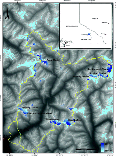
a Glacier Area and Hypsometry
Through the Western Canadian Cryospheric Network (WC2N), Bolch, Menounos, and Wheate (Citation2010) completed an inventory of glaciers in British Columbia and Alberta. This work provides the areal extents for the glaciers used in this study, based on Landsat Thematic Mapper (TM5) imagery from 2004 to 2006. Glaciers are sub-divided into watersheds based on a 25 m Digital Elevation Model (DEM). Total glacierized area in the Illecillewaet River basin in 2005 was 56.0 km2, or 4.9% of the IRB. Glaciers in the basin range from 0.05 to 5.94 km2. Most of the glaciers in the basin are less than 1 km2 and most of the glacier area is associated with the size class 1–2.99 km2 (). Illecillewaet Glacier is the largest ice mass in the basin, covering 5.94 km2 and representing 11% of the total glacierized area. The glacier is the largest outlet of the Illecillewaet Icefield, draining northward into the IRB; other outlets of the icefield drain into different hydrological catchments to the south and southwest. Illecillewaet Glacier is the one of the most accessible glaciers in the basin and was used to collect mass balance and meteorological data (see Section 3).
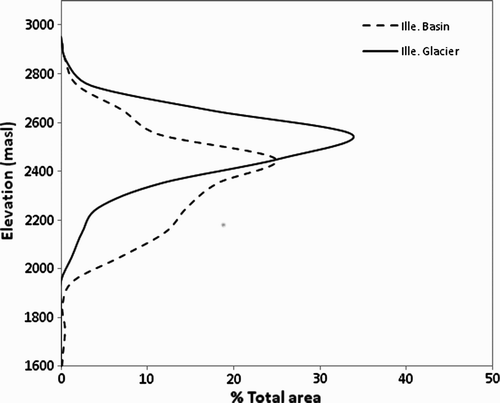
Glacier hypsometry in a basin provides baseline data for regional estimates of glacier mass balance and meteorological sensitivity (Marshall et al., Citation2011). A 20 m DEM was obtained from Parks Canada to assess glacier hypsometry in the IRB. The DEM was derived from aerial photographs, acquired in approximately 1997 from Terrain Resources Information Management (TRIM). The elevation range of the Illecillewaet Glacier is 1993 to 2911 m, while the elevation of the IRB glaciers ranges from 1592 to 2942 m ( and ). The elevations of Illecillewaet Glacier are reasonably representative of IRB glaciers because there is limited glacierized area below 2000 m, the lowest reaches of Illecillewaet Glacier (). The median glacier elevation for the IRB is 2385 m, 136 m below that of Illecillewaet Glacier.
Table 2. Glacier area and elevation statistics for Illecillewaet Glacier and glaciers within the Illecillewaet River sub-basin (IRB), 2005.
Fig. 2 Percentage of glacierized area versus elevation for the Illecillewaet Glacier and in the Illecillewaet basin.
Given its close proximity to Rogers Pass, the Canadian Pacific Railway line, and the TransCanada Highway passing through the area, Illecillewaet Glacier has been extensively photographed and visited. It was the site of several early twentieth century investigations of glacier motion and glacier retreat, and historical changes in Illecillewaet Glacier terminus position and area have been documented (Champoux & Ommanney, Citation1986; Sidjak & Wheate, Citation1999). Loukas, Vasiliades, & Dalezios (Citation2002) project future glacier-area evolution in the IRB under different climate regimes, estimating a glacier cover of 51 km2 by 2080–2100, 5 km2 smaller than its current area.
Glaciological projections and hydrological modelling in the basin do not benefit from regional glaciological data, however. No mass balance measurements have been reported from Illecillewaet Glacier. The federal government carried out mass balance studies on nearby Woolsey Glacier from 1966 to 1975, but these measurements were abandoned. Hence, there is little knowledge of glacier mass balance, high-elevation snowpack, and meteorological gradients in the IRB, or in other headwaters catchments of the CCRB.
3 Methods
a Mass Balance Measurements
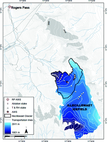
To address the lack of essential glaciological data in the CCRB, we initiated mass balance studies on Illecillewaet Glacier in 2009. Mass balance measurements have subsequently been taken over by Parks Canada, in conjunction with the National Glaciology Program at Natural Resources Canada, with winter balance data available from 2009 to 2012 and summer balance data from 2009 to 2011. From late April until mid-September 2009, an intensive field study was carried out on Illecillewaet Glacier to measure biweekly snow accumulation, snow and ice melt, and meteorological conditions along a centre line transect on Illecillewaet Glacier ().
Fig. 3 Topographic contour map of the Illecillewaet Icefield study area, with an elevation contour interval of 50 m (100 m on the glaciers). The field instrumentation from summer 2009 is also indicated. AWS; automatic weathers station; RP: Rogers Pass; T and RH: temperature and relative humidity stations, respectively.
Point snowpack measurements were taken on 1 May 2009 through a combination of probed snow depths and snow density measurements at several locations on the glacier, to derive snow water equivalent (w.e.) or SWE. Snow density was measured through a combination of snowpit profiling and snow-core estimates. Snow w.e. on 1 May is taken to represent the winter accumulation (bw ) on Illecillewaet Glacier, with point measurements extrapolated to give the glacier-wide winter mass balance (m3 w.e. a−1). We express this as the mean specific balance for the glacier, Bw (m w.e. a−1) through normalization by the glacier area. In interior regions of western Canada, seasonal melting at the elevation of the glaciers typically begins in May and extends through September. Stake measurements provide data on summer mass balance, with point values extrapolated to give glacier-wide surface mass balance, Bs . Combining the two measurements delivers the net balance, Bn = Bw + Bs . Any mass added through summer snow events is implicitly included in Bs .
In 2009, a total of 13 stakes were drilled into the glacier every 50 m in elevation along the centre line (NW–SE). Seven additional stakes were established along two transverse lines 200 m apart (). Winter balance (snow accumulation) was measured at all stake locations in early May. Beginning in 2010, mass balance surveys have been conducted by Parks Canada, with a total of seven stakes spaced approximately every 100 m in elevation along the same centre-line transect. Measured winter and summer balances are regressed against elevation () and linearly extrapolated to the entire glacier. Error analysis for mass balance results is based on the estimated error in glacier area and hypsometry (e.g., through non-contemporaneous imagery) and measurement errors for snow depth, snow density, and stake height.
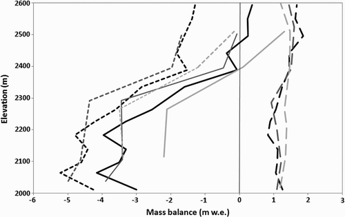
Fig. 4 Vertical profiles of Illecillewaet Glacier for winter (long dashed lines), summer (short dashed lines), and net mass balances (solid lines) for 2009 (black), 2010 (dark grey), and 2011 (light grey).
b Meteorological Measurements
Meteorological input data needed to model glacier melt were collected from an automatic weather station (AWS) and secondary weather stations positioned on and off the Illecillewaet Glacier from 1 May to 14 September 2009 (). Air temperature, humidity, and precipitation, were recorded by secondary weather stations mounted on poles drilled into the ice and spaced every 100 m in elevation. The centre-line transect of temperature loggers was used to measure temperature lapse rates on the glacier.
The AWS was mounted on a tripod at an elevation of 2435 m and was configured to record temperature, humidity, precipitation, wind speed and direction, air pressure, and incoming and outgoing shortwave and longwave radiation. Measurements at the AWS were taken every 10 seconds, with average values stored every 10 minutes on a Campbell Scientific datalogger (CR1000). Next to the AWS an ultrasonic ranger (SR50) was installed on a fixed pole to record snow or ice surface height every 30 minutes.
To supplement the data gathered in summer 2009, we use hourly precipitation, humidity, and temperature data from an Environment Canada weather station at Rogers Pass, which has been operational since 1966. The station is at an elevation of 1340 m and is 9.3 km from the glacier AWS. Winter (September to May) precipitation at Rogers Pass averaged 1278 mm from 1966 to 2011, while mean summer (June, July, August) temperature averaged 12.0°C over this period. For our study period, winter precipitation deviated from the long-term mean by −18%, −16%, and +10% in 2008–09, 2009–10, and 2010–11, respectively. Mean summer temperature anomalies from 2009 to 2011 were 1.2°C, −0.1°C, and −0.7°C, respectively. Mass balance year 2008–09 was therefore warm and dry, which should drive a more negative mass balance; 2009–10 was relatively normal, and 2010–11 was cool and wet in the region, conducive to positive mass balance.
c Illecillewaet Glacier Melt Model
We develop and calibrate a local melt model at the AWS site and then apply it to Illecillewaet Glacier at 20 m resolution. Spatially distributed energy balance investigations are necessary to understand and simulate glacier melt better (e.g., Hock, Citation1999; Wagnon, Ribstein, Kaser, & Berton, Citation1999). Although a complete energy budget approach is the ideal way to model glacial melt, it demands many observations which are generally unavailable. Instead, temperature-index models that are based on cumulative positive degree days (PDD) have proven to be useful in glacio-hydrological studies. The “classical” degree-day temperature-index model captures seasonal patterns in runoff and is likely sufficient for long-term analyses (e.g., Braithwaite, Citation1995), and it has been applied in a wide variety of regions (e.g., Jóhannesson, Sigurdsson, Laumann, & Kennett, Citation1995; Rango et al., Citation2008).
However, PDD models do not capture daily and seasonal runoff variability well (Hock, Citation1999), in part because degree-day factors can vary considerably in space and time (e.g., Hock, Citation1999; Singh and Kumar, Citation1997). Modified degree-day models that include solar radiation (e.g., Hock, Citation1999; Pellicciotti et al., Citation2005) capture daily cycles better, as well as spatial variations in melt resulting from topographic influences (i.e., effects of shading, slope, and aspect). Temperature-index models that incorporate treatments of potential direct incoming solar radiation are well established (e.g., Hock, Citation1999, Citation2003; Moore, Citation1993; Pellicciotti et al., Citation2005; Shea, Moore, & Stahl, Citation2009), because potential direct solar radiation is readily calculated.
1 MELT PARAMETERIZATION
Here we adapt the temperature-index melt models of Hock (Citation1999) and Pellicciotti et al. (Citation2005), using absorbed solar radiation rather than potential direct solar radiation in our melt model. Pellicciotti et al. (Citation2005) also consider absorbed solar radiation, in a bivariate relation with PDD (i.e., two separate melt terms). Because absorbed solar radiation and degree days are highly correlated, we take a different approach and combine these into a single term:
Equation (1) introduces additional complexity relative to Hock (Citation1999) because of the need for information on surface albedo and atmospheric cloud conditions. Temperature, albedo, and incoming solar radiation all need to be measured or parameterized. Where AWS data are available, this can be evaluated directly. We determine TF and SRF based on observations at the Illecillewaet Glacier AWS site and from our ablation stakes in summer 2009, using three-day averaged melt data from the AWS ultrasonic depth gauge (SR50) and biweekly melt data from stake ablation measurements. To convert SR50 and stake measurements to water equivalence, initial snowpack density was measured from four snowpits (2000, 2200, 2400, and 2600 m) in 2009 and three snowpits (2200, 2400, and 2600 m) in 2010 and 2011. Ice lenses and glacier ice are assumed to have a density of 917 kg m−3. We neglect the effects of snow densification through the summer. Half of the days from our study period, 1 May to 14 September 2009, are used to calibrate the model, with the other days reserved for model evaluation. Once calibrated, the melt model can be applied to other points on the glacier as well as to other years.
2 TEMPERATURE INPUTS
For distributed modelling of snow and ice melt, hourly temperature is modelled as a function of elevation, using measured lapse rates on the glacier. For 2009 this is based on hourly mean temperatures recorded at the AWS,
3 RADIATION AND TRANSMISSIVITY
Radiation and albedo data are available for the AWS site but must be estimated elsewhere on the glacier. Potential direct solar radiation, Iϕ , is calculated for each glacierized grid cell by running hourly ArcGIS Area Solar Radiation, which incorporates solar radiation at the top of the atmosphere, a specified clear-sky atmospheric transmissivity (τ), solar geometry, and topographic characteristics (slope, aspect, and shading) (see, e.g., Oke, Citation1987). We find the optimal τ value by comparing measured daily incoming solar radiation for clear-sky days with modelled potential direct solar radiation. Diffuse proportions of incoming radiation are assumed to be 20% (Arnold, Willis, Sharp, Richards, & Lawson, Citation1996).
Cloud cover reduces the solar radiation that reaches the surface, relative to the potential direct value. From the AWS data, we calculate the fraction of daily mean radiation relative to the potential direct radiation in order to derive a clear-sky index: f cs = I/Iϕ . This is evaluated daily to provide an index f cs ∈ [0,1], with f cs = 1 indicating clear-sky (cloud-free) conditions and f cs → 0 for overcast skies. Daily values of f cs are assumed to apply glacier-wide, allowing an estimate of incoming solar radiation I = f cs Iϕ to be applied in Eq. (1) for distributed melt modelling. In years when we lack radiation data, f cs is parameterized as a function of temperature and humidity conditions at Rogers Pass (see below).
4 ALBEDO
Albedo also needs to be estimated at all points on the glacier. Snow albedo increases after a fresh snow event and declines through the summer melt season as a result of grain recrystallization, liquid water content, and increasing concentrations of aerosols and debris in a melting snowpack (e.g., Brock, Willis, Sharp, & Arnold, Citation2000; Klok & Oerlemans, Citation2004). Based on observations at the AWS site, we parameterize the summer snow-albedo evolution, αs (t) as a function of cumulative positive degree days, Σ DD (t), following a logarithmic fit:
Parameters a and b are fit to the data and are assumed to apply at all locations on the glacier. Once the seasonal snowpack melts away, fixed albedo values for firn or ice are assigned, based on measurements of old snow and bare ice at the AWS site.
Fresh snowfall events in the summer have a large effect on the surface albedo, reducing summer melt (Brock et al., Citation2000; Oerlemans & Klok, Citation2004). These were measured in summer 2009 by direct observations during biweekly site visits, SR50 snow-surface heights, and the AWS albedo data. Snow-water equivalence (SWE) is estimated for fresh snow events based on the depth of the fresh snow and measurements of snow density from summer snowfall events. When a summer snowfall occurs, surface albedo is reset to a fresh snow value until the fresh snow melts away, at which time the previous underlying surface value, from Eq. (3) or for bare ice or firn, is restored. Snow events at the AWS site may correspond to rainfall at lower elevations. Based on observations from the AWS site, we adopt a local (grid cell) DD threshold of 4°C d−1 to determine whether a summer precipitation event manifests as snow or rain.
d Illecillewaet Basin Model
Winter mass balance for other glaciers in the IRB is estimated through extrapolation from Illecillewaet Glacier, based on a linear regression of May bw against elevation on Illecillewaet. We therefore assume that the observed snowpack, its variation with altitude, and their interannual variability are representative of other glaciers in the basin.
Application of the melt model to the IRB requires data for temperature, lapse rates, cloud cover, and summer snow events. This is available for Illecillewaet Glacier in 2009, but for 2010 and 2011 we use hourly weather data from Rogers Pass. This includes temperature data for DD estimates, lapsed to different elevations in the IRB, along with parameterizations of cloud cover and summer snowfall based on Rogers Pass temperature, humidity, and precipitation data. These adaptations to the melt model are explained below. The mass balance and runoff models are then extended to all the glaciers in the IRB.
The observed relation between hourly temperature at Rogers Pass and the glacier AWS is used to extrapolate high-elevation temperatures. This is not a simple matter of adopting a fixed lapse rate, because near-surface air temperatures are determined by local surface energy balance (i.e., heat absorption in a forested versus glaciated environment) and by local air movements, such as cold air drainage patterns (see, e.g., Pepin & Losleben, Citation2002; Petersen & Pellicciotti, Citation2011; Shea & Moore, Citation2010). As discussed in Section 4, we observe a strong diurnal relation in the temperature difference between the Rogers Pass AWS and the glacier AWS and use this as the basis for temperature extrapolation to the glaciers.
Glaciers in the IRB occupy different aspects and experience different degrees of topographic shading, so the radiation-based melt model is essential for basin-scale distributed modelling. Potential direct solar radiation is readily modelled over the entire IRB. Effective daily cloud cover (f cs) measured at Illecillewaet Glacier cannot be expected to apply to the whole basin, but it may be “statistically” reasonable over the course of a summer. That is, the number of clear-sky and heavily overcast days may be similar across the IRB, because these are generally dictated by synoptic weather patterns during the summer season. Furthermore, the subset of glacierized IRB locations occupy a similar range of elevation, mostly above 2000 m, and are likely to experience common sky conditions (e.g., similar transmissivity and immunity to valley fogs).
Nevertheless, cloud conditions in summer 2009 are not necessarily typical of other summers, so we develop a proxy for the clear-sky index, f cs, based on observed diurnal temperature patterns and atmospheric humidity. Bristow and Campbell (Citation1984) parameterize mean daily cloud cover and/or atmospheric transmittance as a function of daily temperature range, Tr = T max – T min. Cloudy days reduce daytime temperature maxima and increase the overnight minima, giving low values of Tr . Other parameterizations relate transmittance to the relative or absolute humidity, which are also rough proxies for cloud cover (e.g., Richardson & Reddy, Citation2004). We examine different combinations of temperature and humidity variables to develop an empirical relation for f cs, calibrated against observations from summer 2009.
Summer snowfall events are well characterized for 2009 but are not known for other years. We explore two approaches to modelling summer snow events: (i) introducing summer snowfall as a stochastic variable and (ii) estimating summer snow events based on daily precipitation at Rogers Pass. For the stochastic approach, the number and frequency of summer snow events is specified, then randomly generated in MATLAB to determine event timing and magnitude. Magnitudes are sampled from a uniform distribution between 1 and 10 cm, based on observations in summer 2009. We introduce this approach as a way of including summer snow events in mass balance models where local station data are unavailable.
For the second method, summer precipitation at Rogers Pass is assumed to be representative of precipitation on the glaciers, and local grid-cell temperatures (daily DD totals) determine whether precipitation falls as snow or rain. We measured vertical precipitation gradients in Illecillewaet valley in summer 2009 and found no significant relationship between precipitation totals and elevation. Hence, we do not apply a precipitation lapse rate. Note that this may be appropriate for summer precipitation events but is not expected to hold true in winter when orographic precipitation is the dominant mechanism of snow accumulation.
Meltwater runoff from the IRB glaciers is our primary interest in this study. Snowpack and melt models are applied to each 20 m × 20 m grid cell to determine the distributed melt, and all meltwater is assumed to run off to the Greeley gauge at the outlet of the basin. We do not apply a hydrological model to route the runoff. Our simplistic approach neglects delays and storage in the glaciers and the groundwater system but may be reasonable for total glacier discharge on a monthly and seasonal time scale.
e Sensitivity Tests
We assess model uncertainties by exploring the parameter space. In particular, we examine the sensitivity of modelled glacier runoff to our assumptions about melt model parameters, cloud conditions, summer-snow frequencies, and initial (1 May) snowpack. There is uncertainty about the winter mass balance gradient and even greater uncertainty with respect to snowpack estimates on other (unmeasured) glaciers in the IRB.
In addition to numerical experiments to evaluate uncertainties, we examine Illecillewaet Glacier's sensitivity to climate variability through systematic perturbations in temperature, precipitation, and the clear-sky index. Using the mass balance and meteorological measurements from 2009 as a reference climatology, we explore the effects of temperature perturbations from −3°C to +3°C, winter precipitation variations from 20% to 220% of the observed 2009 snowpack, and clear-sky index (f cs) variations from 0.65 to 0.90 on mass balance and glacier runoff.
4 Results
a Mass Balance Measurements
May snowpack (bw ) data are available from 2000 m to 2600 m on Illecillewaet Glacier. Linear regression of these data in 2009, for which we have the most detailed snowpack information, gives a balance gradient of βP = 0.92 mm w.e. m−1 (R 2 = 0.61; ). Winter mass balance measurements from May 2010 to 2012 indicate a weaker elevation gradient, with a mean value of βP = 0.73 mm w.e. m−1 for 2009 to 2012. These values are comparable to precipitation lapse rates adopted in other studies (e.g., Stahl, Moore, Shea, Hutchinson, & Cannon, Citation2008).
Observations indicate that winter accumulation on Illecillewaet Glacier increases approximately linearly with elevation up to the last measured stake at 2600 m, the altitude of the main icefield plateau. Above this elevation we assume that winter accumulation levels off at the value measured at 2600 m. This may overestimate the snow at the higher elevations, because slopes above this tend to be steep and wind scoured. Winter balances at elevations below 2000 m and above 2600 m are uncertain because of the lack of direct measurements. The regression functions for bw (z) provide winter snowpack estimates that can be extrapolated to all grid cells on Illecillewaet Glacier and for the IRB, providing Bw and the initial snowpack that is input to the melt model.
summarizes the observed mass balance data on Illecillewaet Glacier from 2009 to 2011. Error estimates are based on the combined uncertainty in measurements and input datasets used to derive the glacier-wide mass balance. We assess these to be 22% for winter balance and 23% for summer balance (Hirose, Citation2012). Average specific mass balances from 2009 to 2011 were Bw = 1.43, Bs = −1.91, and Bn = −0.48 m w.e. a−1. All three years had negative net mass balances, with the most extensive melting and runoff in 2009.
Table 3. Observed and modelled mass balance and glacier runoff, 2008 to 2011 (m w.e.) of Illecillewaet (Ille) Glacier and Illecillewaet River Basin (IRB). Uncertainty estimates are discussed in the text.
b Meteorological Measurements
Monthly mean meteorological data collected at the glacier AWS are summarized in and calibrated parameter values from field measurements are found in .
Table 4. Monthly mean weather at the Illecillewaet Glacier AWS site, summer 2009.
Table 5. Parameter values calibrated from field measurements.
1 TEMPERATURE
A mean summer temperature lapse rate of βT = −0.0067°C m−1 (R 2 = 0.94) was measured from the transect of temperature stations on Illecillewaet Glacier, with high correlations between all glacier stations. Temperatures at Rogers Pass have a complex relationship with those on the glacier, however. For 1 May to 14 September 2009, the mean temperature difference between the glacier AWS and the AWS at Rogers Pass, ΔTm , was −7.8°C. There is a strong diurnal pattern to the temperature differences (), with mean midday and overnight differences of about −13°C and −3°C, respectively (i.e., a 10°C diurnal cycle about the mean temperature offset of −7.8°C). Daytime heating at Rogers Pass, relative to the glacier, may be caused by the lower albedo in the valley-floor environment, resulting in increased solar absorption. Closure of the overnight temperature difference is consistent with cold air drainage, driving weak or inverted overnight lapse rates. This systematic diurnal cycle means that a constant offset (i.e., static lapse rate adjustment) from Rogers Pass to the glaciers would give daytime temperatures that are too high, leading to excessive modelled melt.
Fig. 5 Hourly temperature differences between the Rogers Pass AWS and Illecillewaet Glacier AWS for all days, 1 May to 14 September 2009 (asterisks), after correcting for the mean summer temperature difference between the sites (−7.8°C). The solid line shows the average temperature difference for each hour and the dashed line shows the best-fit sine wave introduced to correct for this diurnal pattern.
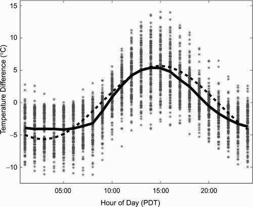
Based on these observations, we introduce a sinusoidal, diurnal temperature correction to make Rogers Pass data more representative of the glacier,
where A is the half-amplitude of the temperature difference; t is the hour of interest, and t lag is the time lag from local solar noon and midnight for the peak temperature difference. Because daily DD totals are the essential variable of interest for glacier melt modelling, we determine A and t lag based on the best fit to observed summer DD totals. Resulting values are A = 5.8°C and t lag = 2.8 hr, shown by the dashed line in .
Temperatures at Rogers Pass are then used to drive the melt model with a three-stage correction: (i) a uniform temperature shift to the reference elevation of the glacier AWS site, ΔTm , (ii) a correction for the diurnal temperature pattern, ΔTd , and (iii) a lapse rate correction for the elevation of the glacier position of interest, after Eq. (2):
2 SOLAR RADIATION
Measurements of average daily incoming solar radiation on clear-sky days, relative to modelled potential direct solar radiation, allow an estimate of atmospheric transmissivity for the site. Fits to the data indicate a value for τ of 0.73 (R 2 = 0.94), within the range of other studies which recommend values of 0.6–0.9 (Hock, Citation1999; Oke, Citation1987). Radiation modelling for the basin was carried out treating τ as a constant. Daily mean potential solar radiation in the IRB averages 315 W m−2 for the summer melt season, 1 May to 14 September, ranging from 22 W m−2 on a northern exposed slope to 433 W m−2 on a southern aspect.
In summer 2009, clouds and atmospheric scattering reduced solar radiation on the glacier by 20%, on average, a clear-sky factor of f cs = 0.80. Daily values for f cs ranged from 0.28 to 1.03. Monthly mean f cs values are relatively consistent, varying from 0.77 to 0.85 (). These mean values could be applied to melt modelling in other years for which we lack radiation data. Alternatively, we examine the relation between mean daily f cs values, daily temperature range, Tr , and humidity variables at Rogers Pass. Of several different combinations of variables, a bivariate combination of Tr and the mean daily vapour pressure, ev , proves to be the strongest predictor of the clear-sky index:
This relation is statistically significant (R 2 = 0.65), with a standard error in f cs of 0.01. This relation allows regional cloud conditions to be parameterized from historical temperature and humidity data at Rogers Pass, or from near-surface temperature and humidity fields in climate model projections.
3 ALBEDO
Seasonal melt had not yet begun at the time of our initial snow surveys and AWS setup in late April 2009. Measurements of early season and fresh summer snow indicate an albedo of 0.85 to 0.9 (). This is borne out by regressions of snow albedo against cumulative DD, which give the relation
Fig. 6 Observed (solid) and modelled (dashed) daily mean albedo at the Illecillewaet Glacier AWS (2450 m elevation).
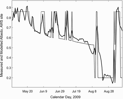
The mean measured albedo of ice at our site was 0.20. Fits of the albedo model to the measured AWS albedo are good (), but the detailed fit is contingent on capturing the fresh-snow events, which briefly boost the albedo back to fresh-snow values. Snow-depth gauge and albedo measurements identify the timing of fresh-snow events, but the amount of snowfall and the altitude of the snowline (i.e., where the glacier received snow rather than rain) in each snowfall event are less certain. We use a fresh-snow density of 145 kg m−3 for summer snow accumulations, based on measurements, and estimate SWE at the AWS through a combination of SR50 records and fits to the albedo data.
To apply this to the rest of the glacier in 2009, we assume the same timing for snow events but determine an elevation threshold where rain transitions to snow based on the local daily DD total. Based on the fresh-snow and meteorological observations at the AWS site, rain is assumed at locations with a daily DD in excess of 4°C d−1; below this, precipitation is assumed to fall as snow.
The total amount of SWE contained in summer snowfall is relatively minor, but its influence on albedo is important. A stochastic model of summer snowfall events is developed based on the frequency of snow events (approximately 10 per summer) and their observed magnitude (up to 10 cm of snow accumulation) in summer 2009. These parameters are varied in sensitivity tests to explore their relative importance to seasonal melt and runoff models. Alternatively, precipitation at Rogers Pass can be extrapolated to the glacier, along with temperature adjustments following Eq. (5), to estimate summer snowfalls. For summer 2009, this method gives similar results to the melt model runs with observed snowfall and with stochastic (N = 10) snow events: Bs values of −2.32, −2.35, and −2.33 m w.e., respectively. Because this is readily applied to other seasons when we lack direct observations of summer snowfall, we adopt the Rogers Pass precipitation extrapolation as our “reference model” for 2010 to 2011 and for basin-scale modelling.
c Illecillewaet Glacier Melt Model
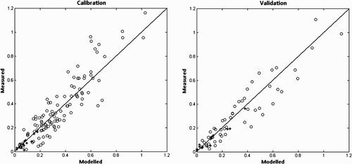
Using measured mass balance and AWS meteorological data, the melt model parameters are calibrated ( and ). Using multiple linear regression the melt model's coefficients are optimized with TF = 0.9308 mm w.e. °C−1 d−1 and SRF = 0.02974 mm w.e. W−1 m2 °C−1 d−1 ((Eq.) 1), significant at the 95% and 99.9% levels of confidence, respectively. Standard errors for the two coefficients are 0.46 mm w.e. °C−1 d−1 and 0.0026 mm w.e. W−1 m2 °C−1 d−1, respectively. The melt model is independently validated at a subset of the ablation stakes and selected biweekly periods of the SR50 data to represent the seasonal, elevation, and surface variability. For the independent test data, R
2 = 0.88 and the mean absolute error w.e. ().
Fig. 7 Observed versus modelled melt (m w.e.) at the AWS and ablation stakes during the calibration and verification periods.
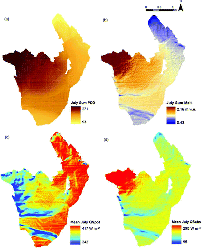
Driving the distributed model with these parameters and with the temperature, radiation, and albedo models described above, glacier-wide melt can be modelled for the summers of 2009 to 2011. Distributed radiation and DD fields for July 2009 are illustrated in . Glacier melt can also be partitioned into that associated with seasonal snow and that caused by melting of glacier ice and firn. Modelled mass balance and Illecillewaet Glacier runoff for 2009 to 2011 are given in . We discuss uncertainty estimates in Section 5b.
Fig. 8 Modelled (a) positive degree days (°C d), (b) melt (m w.e.), (c) potential direct solar radiation (W m−2), and (d) absorbed solar radiation (W m−2) on Illecillewaet Glacier, July 2009.
d Illecillewaet Basin Melt Model
Basin-wide glacier snow accumulation and melt from 2009 to 2011 can be calculated by extension of the methods used for Illecillewaet Glacier. Because glacier hypsometries and solar radiation fields differ between Illecillewaet Glacier and the IRB, different specific mass balances are predicted. To estimate Bw , we extrapolate from the observed Illecillewaet Glacier winter snowpack, based on the observed altitude gradient, βP , for each year. The melt model can be applied directly to the basin. Model simulations indicate more negative summer and annual mass balances for the IRB as a whole, relative to Illecillewaet Glacier (). For the 2008–09 balance year, modelling of the IRB gives Bw = 1.45, Bs = −2.68, and Bn = −1.25 m w.e. Snow accumulation is 7% less than on Illecillewaet Glacier, and there is 16% more summer melt, with both factors contributing to the more negative mass balance. Modelled glacier runoff for the basin is 150 × 106 m3 in 2009, with 45% of this derived from ice and firn melt.
For the three-year composite, 2009 to 2011, IRB mass balances are Bw = 1.38, Bs = −2.01, and Bn = −0.63 m w.e. (), and modelled glacier runoff averages 112 × 106 m3, of which 34% comes from glacial ice and firn. Differences in annual mass balance are primarily driven by summer temperature and cloud cover, with winter snowpack having a secondary influence for these years. Frequent summer snowfalls also contribute to the reduced melting and runoff in summer 2011.
5 Discussion
a Observed and Modelled Mass Balance
Here we discuss the observed and modelled mass balance and total glacier runoff from Illecillewaet Glacier. There are no observations to evaluate this on the scale of the IRB, but we discuss basin-scale mass balance in the context of glacier discharge in Section 5d.
Average Illecillewaet Glacier mass balance was negative from 2009 to 2011, but there is interesting interannual variability in the seasonal balances and summer runoff. The 2008–09 balance year was the most negative of the three years, 2009–10 was slightly negative, and mass balance in 2010–11 was close to a state of balance (). Summer runoff from the glaciers decreased in each of the three years. These results are consistent with available meteorological observations at Rogers Pass, which indicate that summer 2009 was warm relative to 2010 and 2011. Mean temperature from 1 May to 14 September 2009 was 10.4°C, compared with values of 9.3°C and 9.1°C in 2010 and 2011, respectively. Relative humidities for this period were 70.8, 73.6, and 74.8% for 2009, 2010, and 2011, respectively. Precipitation was recorded at Rogers Pass on 65 days in summer 2009, compared with 78 and 71 days in the two subsequent summers. This indicates relatively cool, overcast summer weather in 2010 and 2011.
Regional snowpack was above normal in the La Niña winter of 2010–11 (Anslow & Roddenhuis, Citation2011). September through April precipitation at Rogers Pass was 1332 mm in 2010–11, 10.4% above the 1965–2011 average of 1206 mm. In contrast, precipitation in 2008–09 and 2009–10 was below normal, with 990 and 1042 mm of September–April precipitation, respectively. It is unlikely that Illecillewaet Glacier winter mass balance was as low as reported in 2010–11, Bw = 1390 mm; this is comparable to the winter precipitation at Rogers Pass and less than the winter mass balance that was measured in 2009. We suspect that high elevation snow depth measurements on the glacier may have been misread because of ice layers or denser snow that was mistaken as firn.
Modelled winter balance in 2008–09 overestimates the balance by 5% relative to the observations (). The linear accumulation gradient that we adopt oversimplifies the snowpack variability. A portion of the glacier also lies above 2600 m, where we do not have measurements. The highest stake data are assumed to apply to all elevations above 2600 m. Winter balance data need to be measured at higher elevations to assess this assumption. These areas on the glacier are steep, avalanche prone, and heavily crevassed, however, making this difficult. These steep upper slopes may retain less snow accumulation, so that both our measured and modelled winter balances overestimate bw at elevations above 2600 m.
The model overestimates summer mass balance by 12% compared with the observed stake data, when extrapolated to the glacier area (). We suspect that the model may be closer to the truth, because it parameterizes snow and ice melt based on energy constraints (i.e., solar variability, albedo, elevation, and aspect), while high-elevation ablation estimates in the “observed” mass balance are from the highest stake data (2600 m). The stake data do not capture important differences in energy inputs on the upper glacier slopes, which have southwest aspects. The highest elevations on the glacier therefore receive greater amounts of solar radiation (c), which will contribute to higher melt rates.
In combination, observed and modelled 2008–09 net mass balances are comparable and well within our uncertainties, at −0.61 and −0.77 m w.e. Discrepancies between observed and modelled net balance are also within the uncertainties in 2009–10 and 2010–11 (), but the melt model underestimates summer melt and annual mass losses in these years, in contrast with 2009. On average, for the three years, observed Bn = −0.48 m w.e. and modelled Bn = −0.24 m w.e. Most of the difference can be attributed to underestimated melt in the model; mass balance observations from 2009 to 2011 indicate a mean summer runoff of 11.3 × 10⁶ m3 compared with a mean modelled runoff of 10.1 × 10⁶ m3. Average Bs and runoff in the model are 11% less than the observational estimate, although values fall within the uncertainties.
b Model Uncertainties
Uncertainties in the model can be explored through perturbation experiments. We examine the sensitivity of modelled runoff and mass balance to the melt model coefficients, clear-sky parameter, and summer snowfall. Additional uncertainties in albedo and temperature values can be considered to be embedded in the melt model coefficients (i.e., they introduce errors similar to having higher or lower values of the coefficients TF and SRF). We vary these parameters individually and in combination, based on the standard error estimates for TF and SRF reported above. For the clear-sky index, f cs, we examine the impact of assuming a constant value for the summer, mean monthly values, or through varying the mean summer value of f cs by ±10%, from 0.72 to 0.88. This exceeds the range of mean monthly values observed at the site. We also explore the importance and sensitivity of modelled runoff to summer snowfall by varying the number of randomly selected snow events from 0 to 20.
Results of these sensitivity tests for Illecillewaet Glacier are compiled in . Sensitivity tests are reported for summer 2009 and the reference model, with Bs = −2.32 m w.e., is based on our optimized parameters and observed temperature, clear-sky index, and summer snow events. The most sensitive free parameter in the melt model is the temperature melt factor TF, for which variation by ±1 standard error gives a range in modelled Bs from −2.59 to −2.03 m w.e. (i.e., ±12%). Uncertainty in SRF gives a variation in summer balance of ±9%, and the sensitivity of summer balance to the clear-sky index is ±10% for f cs ranging from 0.72 to 0.88.
Table 6. Sensitivity of modelled Illecillewaet Glacier 2008–09 mass balance and runoff to parameter uncertainties and climatic conditions. The final column is the percentage of glacier runoff associated with ice and firn melt as opposed to seasonal snow.
We have observations of the timing and extent (water equivalent) of summer snow events in 2009, but this needs to be parameterized for other years. Our two main methods for this, randomly generated snow events and extrapolation of daily precipitation at Rogers Pass, give similar results for the summer 2009 mass balance: Bs = −2.33 and −2.32 m w.e., respectively. The sensitivity of Bs to summer snowfall is evaluated by varying the number of summer snow events, relative to our reference value of 10 snow events in summer 2009. This introduces less uncertainty than the melt parameters, with Bs varying from −2.43 to −2.25 m w.e. (+5 to −3%) for 0–20 summer snowfall events, although it is important to emphasize that summer snows have a non-negligible impact on summer mass balance.
Taking uncertainties in TF, SRF, f cs, and summer snow frequency as additive (using the root mean square error), modelled Bs = −2.32 ±0.42 m w.e. (±18%). Modelled summer runoff from the glacier has the same uncertainty: Q = 13.9 ±2.5 × 10⁶ m3.
Accurate estimates of the winter snowpack also represent a major source of uncertainty in our model, particularly at the basin scale. Experiments in which we allow snow accumulation to increase with altitude above 2600 m, rather than levelling out at this altitude, have only a small effect on Bw (+1%; ). We also carry out experiments in which the accumulation gradient βP ranges from 0.5 to 1.3 mm w.e. m−1, relative to the reference value of 0.92 mm w.e. m−1. This range of values in the accumulation lapse rate brackets the interannual variability observed from 2009 to 2012. Resulting winter balance for 2009 ranges from 1.35 to 1.74 m w.e. (), 13% of the reference model value. Based on these numerical experiments, we adopt 15% as the uncertainty for modelled winter balance (i.e., Bw = 1.55 ± 0.23 m w.e.).
Net balance, Bn , has a greater uncertainty because of the compounding uncertainties in Bw and Bs . We assess Bn for 2008–09 at −0.77 ± 0.48 m w.e., with an average value of Bn = −0.24 ± 0.22 m w.e. from 2009 to 2011. Our best estimates predict cumulative mass loss, with Illecillewaet Glacier near a state of balance in 2010–11. Within confidence limits, modelled mass balance is consistent with observations for this period.
Our error estimates are conservative relative to those typically reported in the literature but are realistic given our short period of study at the site. Direct measurements of stream discharge and additional summer albedo and melt observations would improve the confidence in summer melt modelling. Targeted observations and a more sophisticated snow-accumulation model are also needed to help reduce the uncertainty in Bw . Development of a detailed snow distribution model would be valuable (e.g., Dadic, Mott, Lehning, & Berlando, Citation2010) and is recommended for future study. Snowpack extent varies from year to year, but patterns of snow deposition on glaciers typically recur, because snow redistribution through processes such as avalanching and wind scouring is primarily a function of the terrain. However, for the same reason, patterns of snow redistribution and measured altitudinal gradients on Illecillewaet Glacier are not necessarily representative of the broader IRB. We therefore increase our uncertainty estimates in basin-scale estimates of Bw from 15 to 25%, in order to bracket available snowpack measurements at Rogers Pass and Mt. Fidelity.
Basin-wide uncertainty in the melt model is also difficult to assess because there is structural uncertainty associated with extrapolation of the Illecillewaet Glacier melt model and Rogers Pass weather conditions to the entire basin. We adopt the confidence limits derived for Illecillewaet Glacier to the IRB simulations (±18%) but acknowledge that this may underestimate the model uncertainty. We have more confidence in the ability of our empirical melt model to be extrapolated to the basin scale, because it is calibrated for a range of weather conditions, and the distributed pattern and intensity of incoming solar radiation are physically based.
Finally, the chosen DEM and glacier mask can also be expected to influence our results. We reran the analysis using a 95 m DEM available from the Shuttle Radar Topography Mission (SRTM; Farr et al., Citation2007). This represents the glacier topography and outlines in somewhat less detail, giving a glacierized area of 54.4 km2 in the IRB watershed compared with 56.0 km2 using the 20 m DEM. Modelled IRB glacier runoff in 2009 with the SRTM topography is 148 × 106 m3, compared with 150 × 106 m3 using the 20 m DEM—1.3% less, mostly explained by the reduced glacier cover. Specific discharge for the IRB is 1.5% higher with the 95 m DEM; Bs = −2.72 m w.e. compared with −2.68 m w.e. for the 20 m DEM. Hence, there are some differences, but these are not significant relative to our overall uncertainly level of approximately 20%.
c Climatic Sensitivity of Illecillewaet Glacier
Sensitivity of Illecillewaet Glacier mass balance to perturbations in temperature and precipitation is shown in . This plots Bn and summer runoff for temperature perturbations, ΔT, from −3 to +3°C, relative to observed temperatures in summer 2009 and for winter accumulation (Bw ) scaled from 20 to 220% of the observed 2008–09 snowpack. Model parameters are set to the reference values for the 2008–09 balance year. Simulated mass balance values and runoff totals for illustrative experiments are given in .
Fig. 9 Sensitivity of modelled Illecillewaet Glacier runoff to perturbations in (a, c) summer temperature and (b, d) winter mass balance. (a, b). Winter (blue), summer (red), and net (black) mass balance, m w.e. (c, d). Glacier runoff (106 m3) from 1 May to 14 September for total runoff (black), snow melt (red), and ice melt (blue).
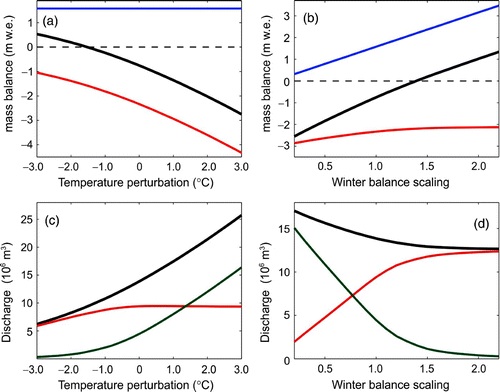
The strong sensitivity to summer temperature is consistent with mass balance observations from 2009 to 2011. A linear fit to the Bn (T) curve in a gives a slope ∂Bn /∂T = −0.55 m w.e. °C−1. A quadratic equation fits the Bn (T) curve better, with Bn = −0.7725 − 0.5458ΔT − 0.0374ΔT 2. This gives a temperature sensitivity ∂Bn /∂T = −0.5458 − 0.0748ΔT, which is equivalent to the linear line of best fit when evaluated at the reference temperature (ΔT = 0). However, modelled temperature sensitivity increases with the extent of warming as a result of the increasing exposure of low-albedo glacial ice. An increase in the summer temperature anomaly ΔT from 0 to 1°C corresponds to ∂Bn /∂T = −0.58 m w.e. °C−1, while warming from ΔT = 1°C to ΔT = 2°C exhibits greater sensitivity: ∂Bn /∂T = −0.68 m w.e. °C−1. Hence, we can conclude that the net balance impact of summer temperature change is about −0.6 m w.e. °C−1, with a non-linear increase under greater warming.
Mountain glacier sensitivity to summer temperature generally exceeds that associated with variability in precipitation (Braithwaite, Zhang, & Raper, Citation2002; Oerlemans and Reichert, Citation2000). For Illecillewaet Glacier, a linear fit to the Bn (P) curve in b gives a slope ∂Bn /∂P = +1.91 m w.e., indicating a net balance change of +0.19 m w.e. for a 10% increase in precipitation. A quadratic fit to Bn (P) is again slightly stronger. For a 30% increase in accumulation relative to the 2008–09 winter balance, dBn = +0.58 m w.e., Illecillewaet Glacier requires a precipitation increase of 30% to offset a warming of 1°C (i.e., to overcome a net balance loss of approximately 0.58 m w.e.). This is consistent with the predictions of Oerlemans and Reichert (Citation2000) for a continental, mid-latitude mountain glacier but contrary to the conclusions of Bürger et al. (Citation2011) at an adjacent basin in the CCRB. Bürger et al. (Citation2011) argue that a 10% increase in precipitation could offset a 1°C warming in the region, but precipitation in the IRB appears to be considerably less than they report (in excess of 3000 mm). Our estimated summer temperature sensitivity is also about twice that of Bürger et al. (Citation2011).
We do not carry out future climate change assessments in this analysis because our objective is to characterize the contemporary basin, but includes mass balance and runoff estimates from Illecillewaet Glacier for projected future climate conditions in the basin (PCIC, Citation2010), a 2°C summer warming and increases in winter snowpack of up to 20%. Summer balance is severely affected by the warming, with Bs = −3.46 m w.e. and Bn = −1.60 m w.e. for this scenario. Increased snow cover delays the transition to bare ice, but the effect is minor relative to the increase in melt energy. Summer runoff is 20.6 × 10⁶ m3 under this climate scenario, 49% higher than the reference model (), although the proportion of runoff associated with seasonal snow is similar at 55%.
d Glacier Contributions to Discharge in Illecillewaet Basin
To compare modelled glacier runoff to Illecillewaet River discharge, monthly streamflows during the 2009–11 glacier melt season were obtained from the Greeley gauging station (Environment Canada, Citation2012a). Mean annual discharge from 1963 to 2011 at Greeley was 52.6 m3 s−1; mean annual discharge rates for 2009, 2010, and 2011 were 41.2, 44.8, and 54.8 m3 s−1, respectively, corresponding to a total runoff of 1300, 1412, and 1735 × 106 m3 a−1, respectively. Hence, discharge rates for 2009 and 2010 were below normal but slightly above normal for 2011, in good accord with the winter precipitation observations in this snowmelt-dominated catchment. The Greeley station records natural flows; we assume that glacier meltwater will discharge through Greeley within the month in order to compare monthly proportions of glacier runoff to the river yield for each ablation year ().
Table 7. Modelled glacier runoff, Qg , which includes meltwater from the seasonal snowpack on the glaciers, Qs , and meltwater from glacier ice and firn, Qi . IRB yield is the total basin discharge measured at the Greeley Hydrometric station for the period of study. The proportions of basin yield resulting from total glacier melt, snowmelt, and ice melt are expressed as percentages, fg , fs , and fi .
We estimate that average glacier volume losses from 2009 to 2011 were equivalent to 112 ± 12 × 106 m3, or 10% of the total May to September discharge in the Illecillewaet River. Glacier runoff contributions decreased from 2009 to 2011, accounting for 14, 11, and 6% of basin yield (). The highest discharges for 2009 and 2010 occurred in July, with snowmelt being the primary contributor. As a result of cooler temperatures, peak snowmelt did not occur until August 2011. As a proportion of Illecillewaet River flows, glacier runoff contributes most heavily in August, constituting 25% of basin yield from 2009 to 2011 and 33% in August 2009. Glacier runoff derived from ice and firn melt represents 16% of the total August yield in the basin.
Fig. 10 Modelled glacier runoff in the IRB, 1 May to 14 September, 2009 to 2011, partitioned into snow (red), ice (blue), and total (black) runoff.
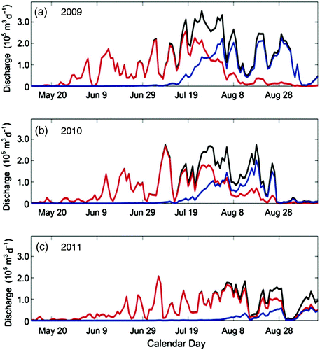
Glacial runoff can be separated into the fraction derived from melting of the seasonal snowpack and that associated with melting of glacier ice and firn. Seasonal snow runoff accounts for 66% of the glacier runoff for the three years, while melting of glacier ice and firn makes up the remaining 34%. The percentage of glacier runoff resulting from ice and firn melt increases continually from May to September, averaging 0, 1, 20, 62, and 69%, in the respective months. This essentially tracks the depletion of the seasonal snowpack and exposure of glacial ice and emphasizes the importance of August and September for the streamflow that is derived from glacier storage.
A heavy winter snowpack or cool summer can dramatically reduce late-summer ice melt, as evidenced in 2011 () and several of the sensitivity tests summarized in . In these cases, total runoff is reduced and the fraction of snowmelt to total glacier runoff increases. In contrast, a low winter snowpack or warm summer causes ice to be exposed earlier in the season, increasing meltwater runoff and glacier depletion.
Rango et al. (Citation2008) assess glacier storage contributions to the Illecillewaet River using a simplified hydrological model. They conclude that for a temperature increase of 4°C, glacier storage (ice) will contribute 134 × 106 m3 a−1 to the IRB. In the warm, dry year of 2009, glaciers in the IRB generated 150 × 106 m3 of runoff in our model, with 67 × 106 m3 derived from glacier ice. Sensitivity analysis indicates a rate of increase in total glacier discharge of 3.7 × 10⁶ m3 °C−1 for Illecillewaet Glacier (c) or 27% °C−1. If warming is accompanied by an increase in precipitation of 10% °C−1 the sensitivity is reduced to 3.4 × 10⁶ m3 °C−1 or 24% °C−1. Applying this temperature sensitivity to the basin, it is expected that runoff will approximately double under a warming of 4°C, equivalent to the results of Rango et al. (Citation2008). Most of this increase would come from ice melt, concentrated from July to September.
Our comparison with IRB yields at Greeley station neglects meltwater losses to evaporation, delays that may be introduced by glacier or groundwater storage, and the potential ecological influences of the river's downstream hydrological balance. Hydrological routing through the glacier and through the basin can introduce delays from days to weeks (Willis, Arnold, & Brock, Citation2002), particularly during the early melt season when runoff is delayed by the snowpack and the subglacial drainage system can be inefficient (Fountain & Walder, Citation1998). Our estimated proportions of glacier runoff to streamflow should, therefore, be treated cautiously with respect to timing of meltwater delivery to the Illecillewaet River. Terrain in the IRB is steep and well drained, particularly in the late summer when the seasonal snowpack has receded. We therefore expect that monthly and total summer runoff estimates are representative. However, daily discharges cannot be compared to basin values without a model of hydrological routing that considers delays and storage terms (e.g., Moore, Citation1993; Stahl et al., Citation2008).
Our mass balance and runoff studies are short term, and we have not sampled a full range of interannual variability in the IRB. The conditions during the three years assessed in this study differed: dry, warm, and clear in 2009; cool and cloudy in 2010; wet, cool, and cloudy in 2011. Meteorological conditions from 2009 to 2011 were typical with respect to the climate normals for Rogers Pass (within one standard deviation), the most proximal site with long-term meteorological observations. Our results are likely to be representative of “normal years” in the basin, for the current glacier extent and hypsometry; past and future magnitudes of glacier runoff will be sensitive to the evolution of the glacierized area in the basin.
e Modelling of Other Time Periods in Illecillewaet Basin
Further research is needed to extend the model to historical runoff reconstructions and future projections of glacier and hydrological change in the IRB. The distributed mass balance and runoff models can be driven by historical (e.g., Rogers Pass) station data. This works well for summer mass balance in our study period, with results comparable to direct observations on Illecillewaet Glacier (statistically equivalent Bs and runoff estimates, within uncertainty bounds). Extrapolation of winter mass balance from historical station records to high-elevation glacial environments is less certain, and methods for this need to be developed.
In general, the method of estimating summer snow events from Rogers Pass daily precipitation (with appropriate temperature adjustments to the glacier) is favourable because this provides a more deterministic treatment of the influence of interannual temperature and precipitation variability. It may not be as helpful for future projections, however, where station data are unavailable and climate models are not generally reliable with respect to precipitation frequency (e.g., Bader et al., Citation2008). We recommend the random snow-event parameterization where the mass balance model is driven by output from climate models.
Ice thickness and volume also need to be known to simulate ice dynamics and glacier evolution. Slope-thickness and volume-area scaling calculations can be used to estimate ice volume, but these are highly uncertain and not applicable for local ice thickness data (Clarke, Berthier, Schoof, & Jarosch, Citation2009; Farinotti, Huss, Bauder, Funk, & Truffer, Citation2009). To our knowledge, there are no measurements of glacier ice thickness within the CCRB. As glacier area and volume are depleted, glacier contributions to runoff will decline, which will be of particular importance in late summer. It is necessary to quantify glacier area and volume changes to understand the regional impacts of diminishing glacier runoff. We recommend that ice thickness characterization be part of a sustained monitoring program within the IRB or other headwaters catchments of the CCRB. Future work should extend the mass balance and high-elevation meteorological observations in the region and aim to refine the snowmelt and accumulation models at the basin scale. Historical weather data are available in the region to characterize glacier runoff over the last several decades, but such an analysis requires a treatment of evolving glacier geometry.
6 Conclusions
Through combined field and modelling studies, we examine the meteorological and mass balance regime of Illecillewaet Glacier. Observations are used to develop and validate an empirical melt model to estimate glacier runoff contributions to Illecillewaet basin, a headwaters catchment of the Columbia River. Required inputs for our model are a DEM, glacier mask, hourly temperature, and winter mass balance (initial May snowpack). Where available, daily humidity and precipitation data can also be applied in estimation of daily cloud cover (incident solar radiation) and summer snowfall.
We find little degradation in model performance for Illecillewaet Glacier when we drive the melt model with nearby valley-bottom weather records from Rogers Pass, rather than using local AWS temperature and radiation data. This requires a two-stage adjustment of Rogers Pass temperature data to make it applicable on the glacier: (i) an elevation correction and (ii) a diurnal temperature correction, to account for daytime heating and overnight cold air drainage in the valley bottom. This was accommodated by applying a sinusoidal temperature correction to Rogers Pass temperatures. Potential direct solar radiation is scaled through a clear-sky index (fraction of transmitted radiation), which is calibrated from AWS data for summer 2009. Daily temperature amplitude and vapour pressure at Rogers Pass provide a good proxy for the clear-sky index, and we use this to estimate incoming solar radiation in 2010 and 2011, when AWS data are not available. The melt model is then applied to Illecillewaet Glacier and the IRB.
Average modelled mass balance from 2009 to 2011 for Illecillewaet Glacier is Bw = 1.46, Bs = −1.70, and Bn = −0.24 m w.e. a−1. This compares reasonably well with average observed mass balances of Bw = 1.43, Bs = −1.91, and Bn = −0.48 m w.e. a−1. A composite of our observed and modelled balances gives an average glacier runoff of 10.9 ± 2.5 × 10⁶ m3 for the three summers, with 24% of this derived from glacier ice and firn. The remaining 76% of Illecillewaet Glacier runoff comes from melting of the seasonal snowpack, including a small contribution from summer snows. Extended to the basin scale, modelled mass balances are lower, specific discharges are higher, and the fraction of modelled glacier runoff derived from ice melt is higher, 34% on average. In a heavy melt year such as 2009, more than 45% of glacier runoff in the basin is attributed to ice and firn melt.
One of the largest uncertainties in our observations and our model is associated with winter snowpack and its distribution to the basin scale. Our melt model is calibrated for a range of weather conditions measured throughout the ablation season, improving our confidence in the summer mass balance estimates. Nevertheless, additional melt data (i.e., a repeat of the intensive observations conducted in summer 2009) would improve calibration and confidence in the melt model parameters, reducing uncertainties in our mass balance and melt model estimates.
Based on climate sensitivity analysis, we conclude that a 1°C warming on Illecillewaet Glacier requires an approximate 30% increase in winter precipitation, to overcome a net balance perturbation of −0.58 m w.e. Under an increase in temperature of 2°C accompanied by a precipitation increase of 20%, relative to our reference summer (2009), runoff increases by 49% while net mass balance declines from −0.77 to −1.60 m w.e. Future projections and climate change studies require a dynamic ice model to assess the impacts of geometric and hypsometric changes on glacier mass balance and runoff.
Our results provide preliminary estimates of glacier contributions to streamflow in the basin, broadly consistent with the hydrological modelling results of Jost et al. (Citation2012), which assess a neighbouring basin with similar glacier extent. Glacier contributions to Illecillewaet Basin averaged 112 ± 12 × 106 m3 from 2009 to 2011, with 66% of this from seasonal snow and 34% from glacier ice and firn. This represents 10% of the summer Illecillewaet River yield from 2009 to 2011. The most significant glacier contributions occur in August, when glacier runoff constituted 25% of the Illecillewaet River from 2009 to 2011. Glacial runoff exceeded 32% of Illecillewaet River yield in August 2009, with more than 80% of this derived from glacier ice.
Winter precipitation and summer temperature conditions for 2009 to 2011 fall within one standard deviation of the “normal” conditions for the region, based on records at Rogers Pass that date to 1966. Hence, these years are representative of the past 46 years. The IRB is a typical headwaters catchment of the CCRB with respect to its terrain, glacier cover, and climate regime. Our results emphasize the importance of glacier contributions to late-summer streamflow in the region and the need to characterize the sensitivity of this water resource to ongoing climate change and glacier retreat.
Acknowledgements
We thank the Natural Sciences and Engineering Research Council (NSERC) of Canada and Parks Canada for support of the Illecillewaet Glacier fieldwork. The University of Calgary and the Canadian Institute for Advanced Research provided additional support. Ongoing hydrological and meteorological data collection by Environment Canada has been essential to this study. The Western Canadian Cryospheric Network, funded by the Canadian Foundation for Climate and Atmospheric Sciences, created a comprehensive glacier inventory of western Canada and sponsored workshops that enabled networking and collaboration. Roger Wheate provided additional assistance. Mt. Revelstoke and Glacier National Parks and the glaciology group at Natural Resources Canada have been instrumental in taking on Illecillewaet Glacier as a long-term mass balance monitoring site.
Related Research Data
References
- Anslow, F. S., & Roddenhuis, D. (2011). Why was this spring and early summer so cool in British Columbia. PCIC Update. Retrieved from http://pacificclimate.org/sites/default/files/publications/PCIC.UpdateSpecial.12Sep2011.pdf
- Arnold , N. S. , Willis , I. C. , Sharp , M. J. , Richards , K. S. and Lawson , W. J. 1996 . A distributed surface energy-balance model for a small valley glacier. I. Development and testing for Haut Glacier d'Arolla, Valais, Switzerland . Journal of Glaciology , 42 ( 140 ) : 77 – 89 .
- Bader, D. C., Covey, C., Gutowski, W. J., Held, I. M., Kunkel, K. E., Miller, R. L., … Zhang, M. H. (2008). Climate models: An assessment of strengths and limitations. Synthesis and Assessment Product 3.1, U.S. Climate Change Science Program. Department of Energy, Washington, DC.
- Bitz , C. M. and Battisti , D. 1999 . Interannual to decadal variability in climate and the glacier mass balance in Washington, western Canada and Alaska . Journal of Climate , 12 : 3181 – 3196 . (doi:10.1175/1520-0442(1999)012<3181:ITDVIC>2.0.CO;2)
- Bolch , T. , Menounos , B. and Wheate , R. 2010 . Landsat-based inventory of glaciers in western Canada, 1985–2005 . Remote Sensing of Environment , 114 : 127 – 137 . (doi:10.1016/j.rse.2009.08.015)
- Braithwaite , R. J. 1995 . Positive degree-day factors for ablation on the Greenland ice sheet studied by energy-balance modeling . Journal of Glaciology , 41 ( 137 ) : 153 – 160 .
- Braithwaite , R. J. , Zhang , Y. and Raper , S. C. B. 2002 . Temperature sensitivity of the mass balance of mountain glaciers and ice caps as a climatological characteristic . Zeitschrift fur Gletscherkunde und Glazialgeologie , 38 ( 1 ) : 35 – 61 .
- Bristow , K. and Campbell , G. S. 1984 . On the relationship between incoming solar radiation and daily maximum and minimum temperature . Agriculture and Forest Meteorology , 31 ( 2 ) : 159 – 166 . (doi:10.1016/0168-1923(84)90017-0)
- Brock , B. W. , Willis , I. C. , Sharp , M. J. and Arnold , N. S. 2000 . Modelling seasonal and spatial variations in the surface energy balance of Haut Glacier d'Arolla, Switzerland . Annals of Glaciology , 36 : 53 – 62 . (doi:10.3189/172756400781820183)
- Bürger , G. , Schulla , J. and Werner , A. T. 2011 . Estimates of future flow, including extremes, of the Columbia River headwaters . Water Resources Research , 47 : W10520 doi:10.1029/2010WR009716 (doi:10.1029/2010WR009716)
- Champoux , A. and Ommanney , C. S. L. 1986 . Evolution of the Illecillewaet Glacier, Glacier National Park, B.C., using historical data, aerial photography and satellite image analysis . Annals of Glaciology , 8 : 31 – 33 .
- Clarke , G. K. C. , Berthier , E. , Schoof , C. G. and Jarosch , A. H. 2009 . Neural networks applied to estimating subglacial topography and glacier volume . Journal of Climate , 22 : 2146 – 2160 . (doi:10.1175/2008JCLI2572.1)
- Cohen , S. J. , Miller , K. A. , Hamlet , A. and Avis , W. 2000 . Climate change and resource management in the Columbia River Basin . Water International , 25 ( 2 ) : 253 – 272 . (doi:10.1080/02508060008686827)
- Comeau , L. E. L. , Pietroniro , A. and Demuth , M. N. 2009 . Glacier contribution to the North and South Saskatchewan Rivers . Hydrological Processes , 23 : 2640 – 2653 . (doi:10.1002/hyp.7409)
- Dadic , R. , Mott , R. , Lehning , M. and Berlando , P. 2010 . Wind influence on snow depth distribution and accumulation over glaciers . Journal of Geophysical Research , 115 : F01012 doi:10.1029/2009JF001261 (doi:10.1029/2009JF001261)
- Demuth , M. , Pinard , V. , Pietroniro , A. , Luckman , B. , Hopkinson , C. , Dornes , P. and Comeau , L. 2008 . Recent and past-century variations in the glacier resources of the Canadian Rocky Mountains: Nelson River system. Special Issue: Mountain glaciers and climate changes of the last century . Terra Glacialis , 11 : 27 – 52 .
- Déry , S. J. , Stahl , K. , Moore , R. D. , Whitfield , P. H. , Menounos , B. and Burford , J. E. 2009 . Detection of runoff timing changes in pluvial, nival and glacial rivers of western Canada . Water Resources Research , 45 W04426. 1–11
- Environment Canada. (2012a) Water Survey of Canada HYDAT data. Retrieved from http://www.wsc.ec.gc.ca/products
- Environment Canada. (2012b) National climate data and information archive. Retrieved from http://www.climate.weatheroffice.gc.ca/ClimateData
- Farinotti , D. , Huss , M. , Bauder , A. , Funk , M. and Truffer , M. 2009 . A method to estimate ice volume and ice thickness distribution of alpine glaciers . Journal of Glaciology , 55 ( 191 ) : 422 – 430 . (doi:10.3189/002214309788816759)
- Farr , T. G. , Rosen , A. P. , Caro , E. , Crippen , R. , Duren , R. , Hensley , S. , Kobrick , M. , Paller , M. , Rodrigues , E. , Roth , L. , Deal , D. , Shaffer , S. , Shimada , J. , Umland , J. , Werner , M. , Oskin , M. , Burbank , D. and Alsdorf , D. 2007 . The Shuttle Radar Topography Mission . Reviews of Geophysics , 45 : RG2004 doi:10.1029/2005RG000183 (doi:10.1029/2005RG000183)
- FCRPS (Federal Columbia River Power System). 2001. The Columbia River system inside story. Retrieved from http://www.bpa.gov/power/pg/columbia_river_inside_story.pdf
- Fountain , A. G. and Tangborn , W. V. 1985 . The effect of glaciers on streamflow variations . Water Resources Research , 21 ( 4 ) : 579 – 586 . (doi:10.1029/WR021i004p00579)
- Fountain , A. G. and Walder , J. S. 1998 . Water flow through temperate glaciers . Reviews of Geophysics , 36 : 299 – 328 . (doi:10.1029/97RG03579)
- Hägeli , P. and McClung , D. M. 2003 . Avalanche characteristics of a transitional snow climate—Columbia Mountains, British Columbia, Canada . Cold Regions Science and Technology , 37 : 255 – 276 . (doi:10.1016/S0165-232X(03)00069-7)
- Hamlet , A. F. and Lettenmaier , D. P. 1999 . Effects of climate change on hydrology and water resources in the Columbia River Basin . Journal of the American Water Resources Association , 35 : 1597 – 1623 . (doi:10.1111/j.1752-1688.1999.tb04240.x)
- Hamlet , A. F. , Mote , P. W. , Clark , M. P. and Lettenmaier , D. P. 2005 . Effects of temperature and precipitation variability on snowpack trends in the western United States . Journal of Climate , 18 : 4545 – 4561 . (doi:10.1175/JCLI3538.1)
- Hirose, J. M. R. (2012). Glacier meltwater contributions and glaciometeorological regime of the Illecillewaet River Basin, a headwaters catchment of the Upper Columbia River Basin, British Columbia, Canada. (M.Sc. thesis). University of Calgary, Alberta, Canada.
- Hock , R. 1999 . A distributed temperature-index ice- and snowmelt model including potential direct solar radiation . Journal of Glaciology , 45 ( 149 ) : 101 – 111 .
- Hock , R. 2003 . Temperature index melt modeling in mountain areas . Journal of Hydrology , 282 ( 1–4 ) : 104 – 115 . (doi:10.1016/S0022-1694(03)00257-9)
- Hopkinson , C. and Young , G. J. 1998 . The effect of glacier wastage on the flow of the Bow River at Banff, Alberta . Hydrological Processes , 12 : 1745 – 1762 . (doi:10.1002/(SICI)1099-1085(199808/09)12:10/11<1745::AID-HYP692>3.0.CO;2-S)
- Huss , M. , Farinotti , D. , Bauder , A. and Funk , M. 2008 . Modelling runoff from highly glacierized alpine drainage basins in a changing climate . Hydrological Processes , 22 : 3888 – 3902 . (doi:10.1002/hyp.7055)
- Jóhannesson , T. , Sigurdsson , O. , Laumann , T. and Kennett , M. 1995 . Degree-day glacier mass-balance modelling with applications to glaciers in Iceland, Norway and Greenland . Journal of Glaciology , 41 ( 138 ) : 345 – 358 .
- Jost , G. , Moore , R. D. , Menounos , B. and Wheate , R. 2012 . Quantifying the contribution of glacier runoff to streamflow in the upper Columbia River basin, Canada . Hydrology and Earth System Sciences , 16, 849–860
- Kite , G. W. 1997 . Simulating Columbia River flows with data from regional-scale climate models . Water Resources Research , 33 ( 6 ) : 1275 – 1285 . (doi:10.1029/97WR00434)
- Klok , E. J. and Oerlemans , J. 2004 . Modelled climate sensitivity of the mass balance of Morteratschgletscher and its dependence on albedo parameterization . International Journal of Climatology , 24 : 231 – 245 . (doi:10.1002/joc.994)
- Loukas , A. , Vasiliades , L. and Dalezios , N. R. 2002 . Climatic impacts on the runoff generation processes in British Columbia, Canada . Hydrology of Earth System Sciences , 6 ( 2 ) : 211 – 227 . (doi:10.5194/hess-6-211-2002)
- Marshall , S. J. , White , E. C. , Demuth , M. N. , Bolch , T. , Wheate , R. , Menounos , B. , Beedle , M. J. and Shea , J. M. 2011 . Glacier water resources on the eastern slopes of the Canadian Rocky Mountains . Canadian Water Resources Journal , 36 ( 2 ) : 109 – 133 . (doi:10.4296/cwrj3602823)
- Moore , R. D. 1993 . Application of a conceptual streamflow model in a glacierized drainage basin . Journal of Hydrology , 150 : 151 – 168 . (doi:10.1016/0022-1694(93)90159-7)
- Moore , R. D. 2006 . Stream temperature patterns in British Columbia, Canada, based on routine spot measurements . Canadian Water Resources Journal , 31 : 41 – 56 . (doi:10.4296/cwrj3101041)
- Moore , R. D. and Demuth , M. N. 2001 . Mass balance and streamflow variability at Place Glacier, Canada, in relation to recent climate fluctuations . Hydrological Processes , 15 : 3473 – 3486 . (doi:10.1002/hyp.1030)
- Moore , R. D. , Fleming , S. W. , Menounos , B. , Wheate , R. , Fountain , A. , Stahl , K. , Holm , K. and Jakob , M. 2009 . Glacier change in western North America: Implications for hydrology, geomorphic hazards and water quality . Hydrological Processes , 23 : 42 – 61 . (doi:10.1002/hyp.7162)
- Oerlemans , J. and Klok , E. J. 2004 . Effect of summer snowfall on glacier mass balance . Annals of Glaciology , 38 : 97 – 100 . (doi:10.3189/172756404781815158)
- Oerlemans , J. and Reichert , B. K. 2000 . Relating glacier mass balance to meteorological data by using a seasonal sensitivity characteristic . Journal of Glaciology , 46 ( 152 ) : 1 – 6 . (doi:10.3189/172756500781833269)
- Oke , T. R. 1987 . Boundary layer climates , 2 , London : Routledge Press .
- PCIC (Pacific Climate Impacts Consortium). (2010). Summary of climate change for Columbia-Shuswap in the 2050s. Retrieved from http://www.plan2adapt.ca/tools/planners?pr=8&ts=8&toy=16
- Pellicciotti , F. , Brock , B. , Strasser , U. , Burlando , P. , Funk , M. and Corripio , J. 2005 . An enhanced temperature-index glacier melt model including the shortwave radiation balance: Development and testing for Haut Glacier d'Arolla, Switzerland . Journal of Glaciology , 51 ( 175 ) : 573 – 587 . (doi:10.3189/172756505781829124)
- Pepin , N. and Losleben , M. 2002 . Climate change in the Colorado Rocky Mountains: Free air versus surface temperature trends . International Journal of Climatology , 22 : 311 – 329 . (doi:10.1002/joc.740)
- Petersen , L. and Pellicciotti , F. 2011 . Spatial and temporal variability of air temperature on a melting glacier: Atmospheric controls, extrapolation methods and their effect on melt modeling, Juncal Norte Glacier, Chile . Journal of Geophysical Research , 116 : D23109 doi:10.1029/2011JD015842 (doi:10.1029/2011JD015842)
- Rango , A. , Martinec , J. and Roberts , R. 2008 . Relative importance of glacier contributions to water supply in a changing climate . World Resource Review , 20 : 487 – 503 .
- Richardson , A. G. and Reddy , K. R. 2004 . Assessment of solar radiation models and temporal averaging schemes in predicting radiation and cotton production in the southern United States . Climate Research , 27 : 85 – 103 . (doi:10.3354/cr027085)
- Shea , J. M. and Moore , R. D. 2010 . Prediction of spatially distributed regional-scale fields of air temperature and vapour pressure over mountain glaciers . Journal of Geophysical Research–Atmospheres , 115 : D23107 doi:10.1029/2010JD014351 (doi:10.1029/2010JD014351)
- Shea , J. M. , Moore , R. D. and Stahl , K. 2009 . Derivation of melt factors from glacier mass-balance records in western Canada . Journal of Glaciology , 55 ( 189 ) : 123 – 130 . (doi:10.3189/002214309788608886)
- Sidjak , R. W. and Wheate , R. D. 1999 . Glacier mapping of the Illecillewaet ice field, British Columbia, Canada, using Landsat TM and digital elevation data . International Journal of Remote Sensing , 20 ( 2 ) : 273 – 284 . (doi:10.1080/014311699213442)
- Singh , P. and Kumar , N. 1997 . Impact assessment of climate change on the hydrological response of a snow and glacier melt runoff dominated Himalayan river . Journal of Hydrology , 193 : 316 – 350 . (doi:10.1016/S0022-1694(96)03142-3)
- Stahl , K. , Moore , R. D. , Shea , J. M. , Hutchinson , D. G. and Cannon , A. 2008 . Coupled modeling of glacier and streamflow response to future climate scenarios . Water Resources Research , 44 : W02422 doi:10.1029/2007WR005956 (doi:10.1029/2007WR005956)
- Wagnon , P. , Ribstein , P. , Kaser , G. and Berton , P. 1999 . Energy balance and runoff seasonality of a Bolivian glacier . Global and Planetary Change , 22 : 49 – 58 . (doi:10.1016/S0921-8181(99)00025-9)
- Willis , I. , Arnold , N. and Brock , B. 2002 . Effect of snowpack removal on energy balance, melt and runoff in a small supraglacial catchment . Hydrological Processes , 16 : 2721 – 2749 . (doi:10.1002/hyp.1067)