Abstract
A brief summary of the first regional analysis of projected changes in extremes for the Canadian Columbia Basin is presented. The study makes use of an ensemble of eight Regional Climate Model simulations from the North American Regional Climate Change Assessment Program. First, the regional models’ historical simulations are compared with their coarse-scale driving data as well as with gridded observations. This analysis indicates that the regional models generally improve upon their coarse-resolution forcing, particularly for precipitation.
By the middle of the twenty-first century, annual mean temperature in the basin is projected to increase by 1.8°C to 2.7°C compared with the past (1971–2000). A 1% to 9% increase in annual total precipitation is projected. These projections are compared with a wider range of projected changes from a larger ensemble of coarse-scale global climate models.
The projected changes to extremes that accompany these changes in mean conditions are considerable. Warm days in summer are projected to occur 1.5 to 3.3 times as often as in the past. Extreme warm days (defined as 25-year return period events appropriate to the reference period) are projected to occur 1.4 to 12.5 times as often as in the past. Cold extremes are correspondingly projected to decrease in frequency or cease altogether.
Projected increases in precipitation during very wet days are similar to the overall annual precipitation increase. The frequency of extreme wet days (25-year return period events) is projected to be between 0.3 and 4.1 times the frequency in the past.
RÉSUMÉ [Traduit par la rédaction] Nous présentons un bref résumé de la première analyse régionale des changements projetés dans les extrêmes pour le bassin canadien du Columbia. L’étude se fonde sur un ensemble de huit simulations de modèles climatiques régionaux issues du programme régional nord-américain d’évaluation du changement climatique. Dans un premier temps, nous comparons les simulations historiques des modèles régionaux avec leurs données d'essai à échelle grossière de même qu'avec des observations à des points de grille. Cette analyse indique que les modèles régionaux améliorent généralement la résolution par rapport aux modèles qui les forcent grossièrement, en particulier pour les précipitations.
Vers le milieu du vingt et unième siècle, la température moyenne annuelle dans le bassin devrait augmenter de 1,8 à 2,7 °C comparativement au passé (1971–2000). Une augmentation de 1 à 9% des précipitations annuelles totales est projetée. Nous comparons ces projections à une gamme plus large de changements projetés à partir d'un plus grand ensemble de modèles climatiques mondiaux à échelle grossière.
Les changements projetés dans les extrêmes qui accompagnent ces changements dans les conditions moyennes sont considérables. Les jours chauds en été devraient se produire de 1,5 à 3,3 fois plus souvent que dans le passé. Les jours extrêmement chauds (définis comme des événements dont la période de retour est de 25 ans en considérant la période de référence appropriée) devraient se produire de 1,4 à 12,5 fois plus souvent que dans le passé. Les températures extrêmement froides devraient réciproquement diminuer en fréquence ou ne plus se produire du tout.
Les augmentations projetées dans les précipitations lors des jours très pluvieux sont semblables à l'augmentation annuelle générale des précipitations. Les jours de précipitations extrêmes (événements dont la période de retour est de 25 ans) devraient se produire de 0,3 à 4,1 fois plus souvent que dans le passé.
1 Introduction
As knowledge of the climate system has improved, analysis of projected change in rare and extreme events has become feasible. This is illustrated by the recent Special Report on Extremes from the Intergovernmental Panel on Climate Change (IPCC), which includes projections on global and continental scales using global climate models (IPCC, Citation2012). Understanding how extremes will change in smaller regions, particularly those with complex topography such as the Columbia River basin, requires analysis with higher resolution climate models.
Changes in the frequency and/or intensity of some types of extremes over the past half century have been observed (Seneviratne et al., Citation2012 and references therein; see also Duffy & Tebaldi, Citation2012), and in some cases formal detection and attribution studies have linked observed changes to anthropogenic influence on the climate system (e.g., Min, Zhang, Zwiers, & Hegerl, Citation2011; Seneviratne et al., Citation2012; Zwiers, Zhang, & Feng, Citation2011). Furthermore, there is an emerging demand to make use of extremes from Regional Climate Models (RCMs) in planning processes (Mishra, Dominguez, & Lettenmaier, Citation2012), which implies a need to assess extremes that are simulated by such models. The importance of extremes in the Columbia Basin was recognized well before any analysis of regional future projections was available (e.g., Murdock, Fraser, & Pearce, Citation2007).
This paper presents a brief summary of the first regional analysis of extremes for the Canadian Columbia Basin. The authors carried out this work as a contribution to the Communities Adapting to Climate Change Initiative managed and supported by the Columbia Basin Trust. The initiative assists communities to adapt to climate change.
Our analysis makes use of RCM results. First we assess RCM simulations of historical temperature and precipitation in the Columbia Basin. Then we present future projections of temperature and precipitation in three ways: (i) annual climatologies, (ii) indices of extremes, and (iii) return periods.
2 Methods
a Study Area
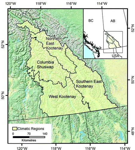
The Canadian Columbia River basin, located in southwestern British Columbia, lies in the intermountain region delineated by the Rocky Mountains to the east and north, and the Monashee Mountains to the west (). The basin features complex topography, with elevations ranging from 350 m to 3400 m (mean elevation of 1600 m).
Fig. 1 Study area: Canadian Columbia River basin (light green) and climatic sub-regions.
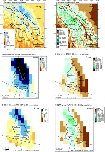
According to a high-resolution historical climatology (Wang, Hamann, Spittlehouse, & Murdock, Citation2012), the 1971–2000 average monthly temperature in the basin ranged from −14.5°C in December to 19.1°C in July with an annual average of 1.6°C; the average monthly total precipitation for the same period ranged from 16 mm in March to 417 mm in December with an annual total of 1160 mm (see top row).
Fig. 2 Historical simulations of annual mean temperature (left) and annual total precipitation (right) for the Canadian Columbia Basin. The top row displays high-resolution (approximately 4 km) climatologies from ClimateWNA (www.climatewna.com; Wang et al., Citation2012), and the middle and bottom rows display climatologies from two RCM historical simulations.
b Regional Climate Models
RCMs operate at a higher resolution than global climate models (GCMs) over a limited area. Therefore, they represent the effects of surface topography on climate more faithfully. The internal structure of RCMs is allowed to evolve freely, similar to GCMs; RCMs are driven at their boundaries by coarser resolution models or by reanalysis (e.g,. Kistler et al., Citation2001). Driving a model by coarse-resolution reanalysis (a gridded coarse-resolution representation of the historical climate based on historical observations assimilated into a global weather forecast model run in a hindcast mode) allows for model evaluation by comparison with historical observations.
The RCM simulations used in this study were obtained from the North American Regional Climate Change Assessment Program (NARCCAP; http://narccap.ucar.edu/; NCAR, Citation2012) and cover most of North America for the historical period 1971 to 2000 and a future period 2041 to 2070. The NARCCAP simulations driven by the National Centers for Environmental Prediction–Deparment of Energy (NCEP-DOE) Reanalysis 2 (NCEP2; Kistler et al., Citation2001) were also used to assess the ability of each RCM to simulate the historical climate for the time period 1980 to 2000.
We used the eight RCM simulations available at the time of analysis ( and ). Our results are thus based on an ensemble with an uneven representation of GCMs and RCMs. The NARRCAP experimental design will provide a balanced ensemble when complete (Mearns et al., Citation2009). We have provided a comparison of projected change for the driving GCMs to a wider ensemble (Sections 3b and 3c).
Table 1. RCM and GCM acronyms, full names, and modelling groups within the NARCCAP project.
Table 2. RCM future projection ensemble members and driving GCMs. An X indicates an ensemble member used in this study driven by the GCM listed in the row for the RCM listed in the column.
We analyzed 3-hourly surface air temperature and precipitation from RCMs with a horizontal resolution of approximately 50 km. These simulations were used to derive indices of extremes and return periods, using methods described in Sections 2c and 2d.
c CLIMDEX Indices
In this paper we consider the CLIMDEX set of standard indices of climate extremes defined by the Expert Team on Climate Change Detection and Indices (ETCCDI; Peterson et al., Citation2001; Zhang et al., Citation2011). The full suite of indices was evaluated (Murdock & Sobie, Citation2013) using the climdex.pcic R-package for the R software programming language (http://cran.r-project.org/web/packages/climdex.pcic/index.html). Three indices have been included for presentation here; they were selected because they are representative of the changes in extremes found in many of the ETCCDI indices.
Two of the selected indices are temperature-related relative threshold exceedance indices: “warm days” (TX90p), which is the percentage of days when daily maximum temperature exceeds the 90th percentile of daily maximum temperatures during the baseline period; and “cool nights” (TN10p), which is the corresponding frequency for the occurrence of daily minimum temperatures below the 10th percentile of daily minimum temperatures during the baseline. They were computed on an annual, seasonal, and monthly basis. These indices are defined relative to percentile thresholds that are appropriate for each day of the year (using a 5-day window centred on that day to obtain a larger sample size) during the 1971–2000 baseline. Thus, these indices measure warm or cold relative to each day's normal rather than using a constant threshold throughout the year.
The other selected index is precipitation-related: “very wet day” precipitation (R95pTOT) is the amount of annual total precipitation during days that exceed the 95th percentile of daily precipitation amounts during the 1971–2000 baseline period. Very wet day precipitation is different from the temperature indices in that it does not measure frequency of occurrence but rather the annual amount of total precipitation that occurs during days when precipitation exceeds the 95th percentile (regardless of the day of the year in which it occurs). Thus, changes in this index reflect a combination of changes to the frequency of occurrence of very wet days as well as changes to their magnitude.
d Return Periods
Changes in extremely rare events were investigated using statistical extreme value theory which predicts that the extremes (maxima and/or minima) of values in large “blocks” of observations will, asymptotically, follow the Generalized Extreme Value (GEV) distribution as the block becomes large under quite general conditions (Coles, Citation2001). The GEV is a three-parameter probability distribution that can be used to approximate the actual distribution of annual extreme values by fitting three parameters: scale, shape, and location. Extreme value theory has been found to work well in many practical applications (Hosking, Wallis, & Wood, Citation1985). It is frequently used in hydrology and is increasingly used to analyze extremes that are simulated by climate models (see, for example, Kharin, Zwiers, Zhang, & Hegerl, Citation2007), where typically a block length of one year is used.
We considered 25-year return period events in maximum temperature, minimum temperature, and 1-day precipitation amount. This corresponds to events so rare that they are expected to happen only once every 25 years, on average. We first estimate the distribution of annual extremes for the historical simulations. Then we repeat this process for the future simulations. Finally, we use known properties of the GEV distribution to estimate future probability of occurrence of events with magnitudes that correspond to the 25-year return period events from the historical distribution. We report future results as a ratio of future to historical probability of occurrence. This analysis was performed using the fExtremes package for the R software programming language which uses the method of L-moments (Hosking et al., Citation1985). Uncertainty was assessed by applying a bootstrapping approach (Kharin & Zwiers, Citation2005) to estimates of the three GEV parameters, resulting in a range of possible results in addition to the best estimate.
e Ranges of Projected Change
In this paper we adopt two conventions with regard to reporting ranges of projected future change. First, when basin-averaged projections from RCMs are reported, the range is given as the least to most projected change from the ensemble of eight NARCCAP runs. Normally, it is preferable to report a range such as the 10th to 90th percentile of results from all runs because this avoids undue influence by the simulations that are most different from the remainder of the ensemble. Indeed, in Section 3b the projected change according to a large ensemble of GCMs is given using the 10th to 90th percentile. In the case of the RCM ensemble, however, we have only eight runs driven by only four GCM forcing runs. Thus, the RCM range generally does not span the full range of GCM projections, so our convention for basin-averaged RCM projections is to describe the range using the minimum to maximum change for the eight runs.
The second convention adopted here (reported in to ) is for results that are not regionally averaged. This again uses the 10th to 90th percentiles but in this case we are considering the spatial range within the region because the percentiles are based on results both from the eight RCM runs and from each grid box individually (approximately 50 for each RCM). This convention has been used elsewhere (Rodenhuis, Bennett, Werner, Murdock, & Bronaugh, Citation2009) to summarize the inter-region variation of RCM results. If there is little difference between the range in regionally averaged projections and the spatial range from individual grid boxes, then this indicates that the projected change is relatively homogeneous spatially within the region.
We also select two runs, the Canadian Centre for Climate Modelling and Analysis Coupled Global Climate Model (CGCM3) driven Weather Research & Forecasting (WRFG) model and the Community Climate System Model (CCSM) driven Canadian Regional Climate Model (CRCM), that tend to represent the higher and lower values of projected change for most variables.
3 Results
a Assessment of Historical Simulations
RCM simulations, GCM simulations, and the NCEP2 reanalysis were compared with gridded observations from multiple sources for the 1980–2000 historical period (Murdock & Sobie, Citation2013). Here we use the gridded 50 km CANGRID observed dataset as a basis for comparison (Zhang, Vincent, Hogg, & Niitsoo, Citation2000). Comparisons with other gridded datasets give similar results, but we chose CANGRID because its spatial resolution is similar to the RCMs themselves, and it has a good representation of the complex topography of the region at this resolution (Murdock & Sobie, Citation2013).
The RCMs produced more accurate representations of Columbia Basin temperature and precipitation climatologies than the coarser resolution NCEP2 reanalysis (). Most RCMs exhibit cold and wet biases relative to gridded observations for the region (). However, simulated historical temperature and precipitation do reflect inter-regional features such as cooler, wetter conditions in the Rocky Mountains and warmer, drier conditions in the south and east of the basin (). Finer scale features such as the strip of warm dry valley running from Kimberley to Golden (known as the Rocky Mountain Trench) cannot be resolved at the 50 km RCM resolution ().
Table 3. Comparison of NCEP2 and NCEP2-driven RCM annual anomalies from their respective 1980–2000 averages to CANGRID 1980–2000 anomalies from average as well as bias (difference of 1980–2000 average from CANGRID) for annual mean temperature and precipitation for the Columbia Basin.
Biases present in temperature and precipitation were investigated by taking annual anomalies from the 1980–2000 climatology for each NCEP2-driven simulation. In addition to bias, the correlation and root mean square error (RMSE) of NCEP2-driven historical RCM and NCEP2 annual anomalies were also calculated with respect to gridded observed anomalies (relative to each record's 1980–2000 average) as shown in . Close agreement of the time series of annual anomalies for each RCM with CANGRID observations ( and ) suggests that the RCM bias was relatively constant during the 1980–2000 historical simulation. This finding suggests that differences from observations were largely systematic biases present in individual RCMs. One simulation (Hadley Regional Model 3 (HRM3)) is considerably warmer than CANGRID (by 2.5°C). Another simulation (CRCM) differs by 3.2°C from CANGRID, in this case with a cold bias. The rest of the RCMs are slightly colder than gridded observations, by an amount that is comparable to the spread between gridded observations themselves, and each one is closer to CANGRID than NCEP2 ().
Fig. 3 Annual temperature (upper panel) and precipitation (lower panel) for the Columbia Basin as simulated by NCEP2-driven NARRCAP RCMs (dashed lines) and from gridded and station observations (solid lines) as anomalies from each record's 1980–2000 period average.
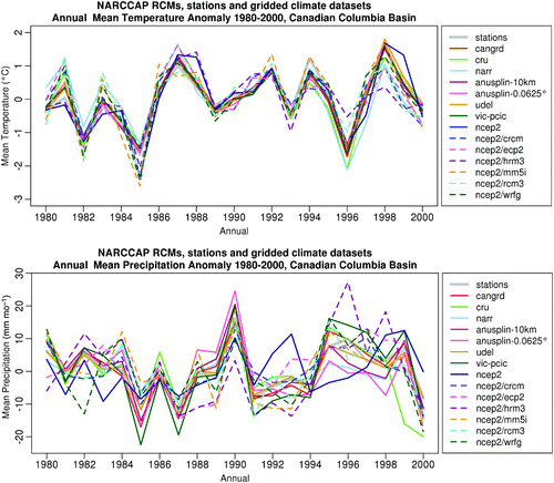
For precipitation anomalies, correlation between NCEP2 and the gridded observations (0.4) was considerably less than values from the RCMs (0.6 to 0.8), while the magnitude of the bias in the NCEP2 reanalysis (36 mm) was much larger than from the RCMs (8 mm to 13 mm). This is expected because higher resolution is more important for spatially complex variables and because the NCEP2 reanalysis precipitation is not corrected to agree with assimilated precipitation observations (Kistler et al., Citation2001). These results indicate that regional climate models more closely represent the basin's climate than their coarse-resolution driving data, particularly for precipitation.
b Projected Temperature Change
All eight simulations from the NARCCAP RCMs showed warming in each of the four climatic regions of the Columbia Basin shown in , during all four seasons (, ). The basin-averaged projected annual warming is 1.8°C to 2.7°C by the 2050s compared with the 1971–2000 baseline. This exceeds the standard deviation of historical temperature climatology, roughly 1°C based on 1971–2000 CANGRID observations (not shown). The projected warming was spatially coherent across the basin ( upper panel), with some runs displaying larger temperature increases in the western part of the basin. Another indication of this spatial coherence is the similarity between the range of projections from individual grid cells and from the basin-averaged values (). The amount of warming did vary seasonally, with some runs projecting greater warming during summer than winter and other runs producing the largest anomalies in the spring and fall ().
Table 4. Summary of projected temperature changes for all individual grid boxes from all eight runs. In addition to minimum, median, and maximum values, the 10th, 25th, 75th, and 90th percentiles of all changes are shown. See Section 2 for definitions of the indices. The 10th and 90th percentiles, in italics, are used to report the range of projected change.
Fig. 4 Projected annual mean temperature (top row), warm days in summer (TX90p – middle row) and cool nights in winter (TN10p – bottom row) for the 2050s from two RCM simulations.
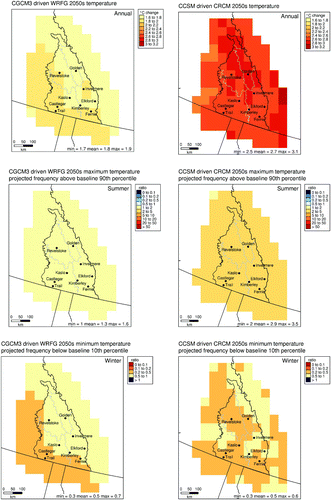
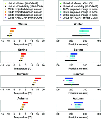
Fig. 5 Seasonal ranges in temperature (left) and precipitation (right) projected change over multiple time intervals from 30 global climate model projections for the Canadian Columbia Basin. Historical mean and variability (represented by ±1 standard deviation of historical values) were obtained from gridded observations (CANGRID), while the GCM projections were obtained from 15 models including both the SRES A2 and B1 scenarios. Also shown for reference (purple dots) are the four GCM projections that provide the 2050s driving conditions for the eight NARCCAP RCM simulations. All projected changes shown are from their respective 1971–2000 baseline.
To put these projected regional-average changes simulated by RCMs in the context of projected change from a larger ensemble, we turn to coarser scale GCMs, for which a larger number of projections are available. We compare, in , the four GCM projections (purple dots) that provide driving conditions for the eight available NARCCAP simulations to 15 GCMs participating in the Coupled Model Intercomparison Project, phase three (CMIP3; Meehl et al., Citation2007) that were forced with both the A2 and B1 scenarios from the Special Report on Emissions Scenarios (SRES; Nakićenović et al., Citation2000). This ensemble is chosen to span the range of projections from the full CMIP3 ensemble and helps identify where in the spread of projections the NARCCAP driving GCMs are located. Note that each of the four NARCCAP driving GCM simulations follow the A2 emissions scenario and two are not members of the CMIP3 ensemble. For more details about the selection of the global models used in this comparison, see the SRES AR4 – PCIC A2+B1 ensemble described in Section 4.3 of Murdock and Spittlehouse (Citation2011).
This analysis considered projections at three different time horizons (the 2020s, 2050s, and 2080s), where each represents a 30-year period (2011–2040, 2041–2070, and 2071–2100, respectively). Results are shown by season for temperature and precipitation (). Warming throughout the twenty-first century is apparent in all seasons. The range in temperature projections expands with time (as expected). The projected changes are compared with historical variability to demonstrate the importance of the magnitude of change (as recommended in Hansen, Sato, & Ruedy, Citation2012). This comparison indicates mean summer temperatures beyond the range of historical variability (as represented by one standard deviation about the historical mean) by the end of the twenty-first century ().
The purple dots in indicate that the four GCM projections that drive the eight runs used here (see ) span some, but not all, of the range of uncertainty from the ensemble of GCM projections. Two of the driving GCMs, CGCM3 in spring, and the Geophysical Fluid Dynamics Laboratory model (GFDL) in summer and autumn, project conditions drier than the range from the CMIP3 ensemble for the Columbia Basin regional average ().
An examination of seasonal temperature extremes (warm days; TX90p) during the summer months revealed that these events are projected to occur 1.5 to 3.3 times more frequently in the future. This range is based on the 10th to 90th percentile of results from all grid boxes and runs and is the convention adopted for reporting range of change throughout the paper (). Cool nights during the winter (TN10p) are projected to decline, occurring 0.4 to 0.7 times as frequently in the future ().
c Projected Precipitation Change
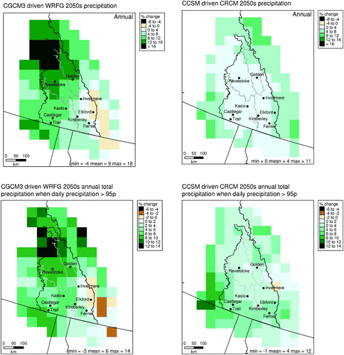
Precipitation projections differ from those for temperature in several ways. First, the range in projected annual precipitation change (1% to 9% increase compared to the 1971–2000 baseline) was small relative to the standard deviation of historical climatology (roughly 30% of the historical mean based on CANGRID). In addition, projected changes in precipitation throughout the twenty-first century from a wide range of GCMs are smaller than historical variability in all seasons (). Furthermore, although several runs indicate larger increases in the northern part of the basin, the future projections were not very spatially coherent. Finally, there were also large differences between individual runs, with runs driven by CGCM3 projecting larger increases than runs driven by the other GCMs. The 1% to 9% range in the regional average projected annual precipitation increase was slightly narrower than the range of 1% to 12% with individual grid-box locations included. When individual months are also considered, a considerably wider full range results (), indicating that projected precipitation change depends considerably on the time of year.
Table 5. Summary of projected precipitation changes for all individual grid boxes from all eight runs and all months. In addition to minimum, median, and maximum values, the 10th, 25th, 75th, and 90th percentiles of all changes are shown. See Section 2 for definitions of the indices. The 10th and 90th percentiles, in italics, are used to report the range of projected change.
The amount of very wet day precipitation (R95Ptot) was projected to increase by 2% to 8% as a percentage of total historical precipitation and with larger increases in the western part of the basin (). The projected change in very wet day precipitation is more consistent throughout the basin and throughout the year than is the projected change in total precipitation itself, consistent with global findings from GCMs (Hegerl, Zwiers, Stott, & Kharin, Citation2004).
Fig. 6 Precipitation projections for the 2050s from two of the eight NARCCAP RCM simulations. The top row displays annual mean monthly precipitation totals, and the bottom row displays moderately extreme precipitation (R95pTOT).
d Return Periods
Return periods describe the typical length of time between occurrences of very rare events. When discussing return periods in both historical and future contexts, it is more useful to consider them as probabilities of occurrence, for example a 25-year event would have a 4% chance of occurring in a given year. This enables a simpler representation of changes to future return periods as an increase or decrease in the probability of occurrence rather than a shift in waiting times. To quantify the magnitude of changes in event frequency, return periods were examined by comparing future projections with the baseline period in the form of a ratio of the two frequencies for a fixed size of event that was estimated from the baseline period.
In the case of the relatively rare (25-year return period) warm temperature events ( top row), six of the eight runs project only increases in the frequency of occurrence at all locations, with the other two runs projecting some instances of decreased frequency at certain grid cells (). Ratios of future to past occurrence range from 1.4 to 12.5 times more often for the daily temperature extremes. The largest ratios are found in the southern and eastern sections of the Columbia Basin. The median result is an increase of 5.1 times more often. This equates to an event that had a 4% chance of occurring during any given year in the past being projected to have a 20% chance of occurring any year on average during the 2050s. The range for cold temperature 25-year return period ratios is <0.1 to 0.6. Results for the 3-hourly duration are very similar to those for daily temperature ().
Table 6. Summary of projected change in the ratio of future frequency of return period to historical frequency for 25-year return periods for all individual grid boxes from all eight runs. In addition to minimum, median, and maximum values, the 10th, 25th, 75th, and 90th percentiles for all changes are shown. See Section 2 for more information about return period analysis. The 10th and 90th percentiles, in italics, are used to report the range of projected change.
Fig. 7 Frequency of projected 2050s 25-year return period temperature (top) and precipitation (bottom) as a ratio to occurrence during the 1971–2000 baseline from two of the eight NARCCAP RCM simulations.
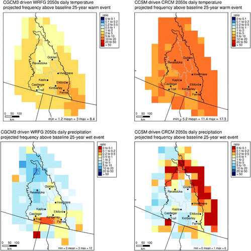
The simulated 25-year return periods for daily precipitation display little spatial coherence within the basin, with considerable differences at adjacent grid cells ( bottom row). Ratios of projected to historical precipitation return periods range from 0.3 to 4.1 based on the 10th to 90th percentile convention we use throughout this paper. However, in this case the minimum and maximum results from all runs and grid boxes include a much wider range from 0 (events never occur) to as high as 12.1. The median ratio is 1.5, which indicates an overall increase in the frequency of extreme precipitation events, although this is accompanied by considerable uncertainty. The spatial patterns of results somewhat resemble projected changes in precipitation itself, with the largest increases occurring in the northern and western parts of the Columbia Basin (compare the top rows of with the bottom row of ). Return periods were also calculated for the 3-hourly duration in addition to daily intervals. The shorter duration results () are quite similar but with slightly larger increases in general (median ratio of 2.0 instead of 1.5 for example).
The upper and lower bounds (obtained by bootstrapping) for the return periods () indicate a considerably wider range of uncertainty than indicated by the best estimates () alone. However, the samples are short, even for estimating 25-year return values. Thus, using methods that borrow strength from adjacent grid boxes to make parameter estimates more robust might be a possibility for future work (Van den Brink & Können, Citation2011).
Table 7. Summary of projected change in the ratio of future frequency of return period to historical frequency for lower bounds and upper bounds of 25-year return periods for all individual grid boxes from all eight runs. In addition to minimum, median, and maximum values, the 10th, 25th, 75th, and 90th percentiles for all changes are shown. See Section 2 for more information about return period analysis.
4 Summary
RCM results from NARCCAP were used to assess projected future change in annual average temperature and annual total precipitation as well as indices of temperature and precipitation extremes and return periods. Comparison of RCM simulations to observations reveals temperature and precipitation biases (). However, these RCM biases were comparable to differences between observed datasets in most cases (Murdock & Sobie, Citation2013) and consistently show improvements () compared with their NCEP2 driving data.
According to the eight RCM runs, the projected annual change by the 2050s compared with 1971–2000 is a warming of 1.8°C to 2.7°C and increased precipitation of 1% to 9%. According to the four driving GCMs used for the eight runs upon which these ranges are based, the projected changes fit within a wider range of projected change according to a set of 30 GCM projections from CMIP3 ().
Warm extremes are projected to increase in frequency, with a range of 1.5 to 3.3 times as many warm days in summer (TX90p), while cold days in winter (TN10p) are projected to decline to about half their historical frequency (). The 25-year return period for extreme warm days is projected to increase in frequency by a factor of 1.4 to 12.5 times, and the 25-year return period for extreme cold days is projected to occur either not at all in future or up to 0.6 times as often as in the past ().
Extreme wet days (R95pTOT) are projected to increase such that the total amount of precipitation during days that exceed the historical 95th percentile increases by 2% to 8% of the annual total 1971–2000 precipitation (). The frequency of extreme wet days (25-year return period events) is projected to be between 0.3 and 4.1 times the frequency in the past, an overall increase in extreme precipitation but with some runs indicating decreases at some locations. The 3-hourly duration precipitation is projected to increase by a slightly larger ratio than the daily precipitation ().
The results of our analysis can be broadly summarized as (i) considerable increases are projected in warm temperature extremes and (ii) modest to major increases are projected in wet precipitation extremes accompanied by considerable uncertainty. These results and an updated analysis of historical trends, variability, and future climate projections (Murdock & Werner, Citation2011) are being incorporated into reports and online tools by the Columbia Basin Trust in support of their Communities Adapting to Climate Change Initiative (e.g., CBT, Citation2012).
Acknowledgements
This work was partially supported by the Columbia Basin Trust. The authors are grateful to Columbia Basin Trust employees and advisors, particularly Kindy Gosal, Ingrid Liepa, Michelle Laurie, Greg Utzig, Dr. Mel Reasoner, Cindy Pearce, Meredith Hamstead, Katherine Mahoney, Jeff Zukiwsky, and Jennifer Ellis and to Pacific Climate Impacts Consortium colleagues James Hiebert, Dave Bronaugh, Dr. Gerd Bürger, Dr. Dave Rodenhuis, and Cassbreea Dewis.
The CRCM data were generated and supplied to the North American Regional Climate Change Assessment Program (NARCCAP) by Ouranos. We wish to thank Ouranos and NARCCAP for providing the data used in this paper. NARCCAP is funded by the National Science Foundation (NSF), the U.S. Department of Energy (DoE), the National Oceanic and Atmospheric Administration (NOAA), and the U.S. Environmental Protection Agency Office of Research and Development (EPA).
Related Research Data
References
- CBT. (2012). Climate change, impacts and adaptation in the Canadian Columbia Basin: From dialogue to action. Columbia Basin Trust (CBT) report, British Columbia. Retrieved from http://www.cbt.org/uploads/pdf/DialoguetoAction_Final_lo-res.pdf
- Coles , S. 2001 . An introduction to statistical modeling of extreme values , London , , UK : Springer .
- Duffy , P. and Tebaldi , C. 2012 . Increasing prevalence of extreme summer temperatures in the U.S . Climatic Change , 111 ( 2 ) : 487 – 495 . doi:10.1007/s10584-012-0396-6 (doi:10.1007/s10584-012-0396-6)
- Hansen , J. , Sato , M. and Ruedy , R. 2012 . Public perception of climate change . Proceedings of the National Academy of Sciences of the United States of America , 109 ( 37 ) : 2415 – 2423 . doi:10.1073/pnas.1205276109 (doi:10.1073/pnas.1205276109)
- Hegerl , G. C. , Zwiers , F. W. , Stott , P. A. and Kharin , V. V. 2004 . Detectability of anthropogenic changes in annual temperature and precipitation extremes . Journal of Climate , 17 ( 19 ) : 3683 – 3700 . doi:10.1175/1520-0442(2004)017<3683:DOACIA>2.0.CO;2 (doi:10.1175/1520-0442(2004)017<3683:DOACIA>2.0.CO;2)
- Hosking , J. R. , Wallis , J. R. and Wood , E. F. 1985 . Estimation of the generalized extreme-value distribution by the method of probability-weighted moments . Technometrics , 27 : 251 – 261 . (doi:10.1080/00401706.1985.10488049)
- IPCC (Intergovernmental Panel on Climate Change) . 2012 . “ Summary for policymakers ” . In Managing the risks of extreme events and disasters to advance climate change adaptation. A special report of Working Groups I and II of the Intergovernmental Panel on Climate Change , Edited by: Field , C. B. , Barros , V. , Stocker , T. F. , Qin , D. , Dokken , D. , Ebi , K. L. , Mastrandrea , M. D. , Mach , K. J. , Plattner , G.-K. , Allen , S. K. , Tignor , M. and Midgley , P. M. 1 – 19 . Cambridge, United Kingdom and New York, NY , , USA : Cambridge University Press .
- Kharin , V. V. and Zwiers , F. W. 2005 . estimating extremes in transient climate change simulations . Journal of Climate , 18 ( 8 ) : 1156 – 1173 . doi:10.1175/JCLI3320.1 (doi:10.1175/JCLI3320.1)
- Kharin , V. V. , Zwiers , F. W. , Zhang , X. and Hegerl , G. C. 2007 . Changes in temperature and precipitation extremes in the IPCC ensemble of global coupled model simulations . Journal of Climate , 20 ( 8 ) : 1419 – 1444 . (doi:10.1175/JCLI4066.1)
- Kistler, R., Kalnay, E., Collins, W., Saha, S., White, G., Woollen, J., … Fiorino, M. (2001). The NCEP/NCAR 50-year reanalysis. Bulletin of the American Meteorological Society, 82, 247–267.
- Mearns , L. O. , Gutowski , W. , Jones , R. , Leung , R. , McGinnis , S. , Nunes , A. and Qian , Y. 2009 . A regional climate change assessment program for North America . Eos , 90 ( 36 ) : 311 – 312 . doi:200910.1029/2009EO360002 (doi:10.1029/2009EO360002)
- Meehl, G., Covey, C., Delworth, T., Latif, M., McAvaney, B., Mitchell, J., … Taylor, K. (2007). The WCRP CMIP3 multimodel dataset: A new era in climate change research. Bulletin of the American Meteorological Society, 88(9), 1383–1394.
- Min , S.-K. , Zhang , X. , Zwiers , F. W. and Hegerl , G. C. 2011 . Human contribution to more-intense precipitation extremes . Nature , 470 ( 7334 ) : 378 – 381 . doi:10.1038/nature09763 (doi:10.1038/nature09763)
- Mishra , V. , Dominguez , F. and Lettenmaier , D. P. 2012 . Urban precipitation extremes: How reliable are regional climate models? . Geophysical Research Letters , 39, L03407, 1–8. doi:201210.1029/2011GL050658
- Murdock, T. Q., Fraser, J., & Pearce, C. (2007). Preliminary analysis of climate variability and change in the Canadian Columbia River basin: Focus on water resources 2006. Victoria, BC: University of Victoria. Retrieved from http://www.pacificclimate.org/docs/publications/CBT.Assessment.pdf
- Murdock, T. Q., & Sobie, S. R. (2013). Climate extremes in the Canadian Columbia Basin: A preliminary assessment. Pacific Climate Impacts Consortium report, University of Victoria. Retrieved from http://www.pacificclimate.org/sites/default/files/publications/Murdock.Sobie.CBT.Extremes.2013.pdf
- Murdock, T. Q., & Spittlehouse, D. (2011). Selecting and using climate change scenarios for British Columbia. Pacific Climate Impacts Consortium report, University of Victoria. Retrieved from http://www.pacificclimate.org/sites/default/files/publications/Murdock.ScenariosGuidance.Dec2011.pdf
- Murdock, T. Q., & Werner, A. T. (2011). Canadian Columbia Basin climate trends and projections: 2007–2010 update. Pacific Climate Impacts Consortium report, University of Victoria. Retrieved from http://www.pacificclimate.org/sites/default/files/publications/Murdock.CBT2007-2010Update.Jul2011_0.pdf
- Nakićenović, N., Alcamo, J., Davis, G., De Vries, B., Fenhann, J., Gaffin, S., … Dadi, Z. (2000). Special Report on Emissions Scenarios. Intergovernmental Panel on Climate Change. Cambridge, UK, and New York, USA: Cambridge University Press. Retrieved from http://www.grida.no/publications/other/ipcc_sr/?src=/climate/ipcc/emission/index.htm
- NCAR (National Center for Atmospheric Research). (2012). North American Regional Climate Change Assessment Program (NARCCAP) [Data]. Retrieved from the National Center for Atmospheric Research Earth System Grid data portal: http://www.earthsystemgrid.org/project/NARCCAP.html
- Peterson, T. C., Folland, C., Gruza, G., Hogg, W., Mokssit, A., & Plummer, N. (2001). Report on the activities of the Working Group on climate change detection and related rapporteurs 1998–2001. Geneva, Switzerland: World Meteorological Organization.
- Rodenhuis, D., Bennett, K., Werner, A., Murdock, T. Q., & Bronaugh, D. (2009). Climate overview 2007: Hydro-climatology and future climate impacts in British Columbia. Pacific Climate Impacts Consortium, University of Victoria, Retrieved from http://www.pacificclimate.org/sites/default/files/publications/Rodenhuis.ClimateOverview.Mar2009.pdf
- Seneviratne, S. I., Nicholls, N., Easterling, D., Goodess, C. M., Kanae, S., Kossin, J., … Zhang, X. (2012). Changes in climate extremes and their impacts on the natural physical environment. In C. B. Field, V. Barros, T. F. Stocker, D. Qin, D. Dokken, K. L. Ebi, M. D. Mastrandrea, K. J. Mach, G.-K. Plattner, S. K. Allen, M. Tignor, & P. M. Midgley (Eds.), Managing the risks of extreme events and disasters to advance climate change adaptation: A special report of Working Groups I and II of the Intergovernmental Panel on Climate Change (pp. 109–230). Cambridge, UK and New York, USA: Cambridge University Press.
- Van den Brink , H. W. and Können , G. P. 2011 . Estimating 10000-year return values from short time series . International Journal of Climatology , 31 ( 1 ) : 115 – 126 . (doi:10.1002/joc.2047)
- Wang , T. , Hamann , A. , Spittlehouse , D. L. and Murdock , T. Q. 2012 . ClimateWNA—high-resolution spatial climate data for western North America . Journal of Applied Meteorology and Climatology , 51 ( 1 ) : 16 – 29 . doi:10.1175/JAMC-D-11-043.1 (doi:10.1175/JAMC-D-11-043.1)
- Zhang , X. , Alexander , L. , Hegerl , G. C. , Jones , P. , Tank , A. K. , Peterson , T. C. and Zwiers , F. W. 2011 . Indices for monitoring changes in extremes based on daily temperature and precipitation data . Wiley Interdisciplinary Reviews: Climate Change , 2 ( 6 ) : 851 – 870 . doi:10.1002/wcc.147 (doi:10.1002/wcc.147)
- Zhang , X. , Vincent , L. A. , Hogg , W. D. and Niitsoo , A. 2000 . Temperature and precipitation trends in Canada during the 20th century . Atmosphere-Ocean , 38 ( 3 ) : 395 – 429 . (doi:10.1080/07055900.2000.9649654)
- Zwiers , F. W. , Zhang , X. and Feng , Y. 2011 . Anthropogenic influence on long return period daily temperature extremes at regional scales . Journal of Climate , 24 ( 3 ) : 881 – 892 . doi:10.1175/2010JCLI3908.1 (doi:10.1175/2010JCLI3908.1)