Abstract
The Columbia Basin Climate Change Scenarios Project (CBCCSP) was conceived as a comprehensive hydrologic database to support climate change planning, impacts assessment, and adaptation in the Pacific Northwest (PNW) by a diverse user community with varying technical capacity over a wide range of spatial scales. The study has constructed a state-of-the-art, end-to-end data processing sequence from “raw” climate model output to a suite of hydrologic modelling products that are served to the user community from a web-accessible database. A calibrated 1/16 degree latitude-longitude resolution implementation of the VIC hydrologic model over the Columbia River basin was used to produce historical simulations and 77 future hydrologic projections associated with three different statistical downscaling methods and three future time periods (2020s, 2040s, and 2080s). Key products from the study include summary data for about 300 river locations in the PNW and monthly Geographic Information System products for 21 hydrologic variables over the entire study domain. Results from the study show profound changes in spring snowpack and fundamental shifts from snow and mixed-rain-and-snow to rain-dominant behaviour across most of the domain. Associated shifts in streamflow timing from spring and summer to winter are also evident in basins with significant snow accumulation in winter (for the current climate). Potential evapotranspiration increases over most of the PNW in summer because of rising temperatures; however, actual evapotranspiration is reduced in all but a few areas of the domain because evapotranspiration is mostly water limited in summer, and summer precipitation decreases in the simulations. Simulated widespread increases in soil moisture recharge in fall and winter in areas with significant snow accumulation in winter (for the current climate) support hypotheses of increased landslide risk and sediment transport in winter in the future. Simulations of floods and extreme low flows increase in intensity for most of the river sites included in the study. The largest increases in flooding are in mixed-rain-and-snow basins whose current mid-winter temperatures are within a few degrees of freezing. The CBCCSP database has been a valuable public resource that has dramatically reduced costs in a number of high-visibility studies in the PNW and western United States focused on technical coordination and planning.
RÉSUMÉ [Traduit par la rédaction] Le projet de scénarios de changement climatique du bassin du Columbia (CBCCSP) a été conçu comme une base de données hydrologiques complète pour appuyer les activités de planification, d’évaluation des répercussions et d'adaptation dans la région pacifique nord–ouest menées par une communauté d'utilisateurs diversifiée disposant de capacités techniques variées dans une large gamme d’échelles spatiales. L’étude a produit une séquence de traitements de données de bout en bout, à la fine pointe, partant d'une sortie « brute » de modèle climatique pour aboutir à une série de produits de modélisation hydrologique, qui sont offerts à la communauté d'utilisateurs via une base de données Web. Nous avons implémenté une résolution latitude–longitude calibrée à 1/16 de degré dans le modèle à capacité d'infiltration variable (VIC) et avons appliqué dans le modèle bassin du fleuve Columbia pour produire des simulations historiques et 77 projections hydrologiques futures correspondant à trois méthodes de réduction d’échelle statistique et trois périodes futures (les décennies 2020, 2040 et 2080). Les principaux produits de l’étude comprennent des données sommaires pour environ 300 sites fluviaux dans la région pacifique nord–ouest et des produits mensuels de Système d'information géographique pour 21 variables hydrologiques couvrant tout le domaine à l’étude. Les résultats de l’étude montrent de profonds changements dans l'accumulation de neige au printemps et des déplacements radicaux de « neige ou pluie et neige mêlées » vers « principalement pluie » dans presque tout le domaine. Des déplacements correspondants des caractéristiques d’écoulement fluvial du printemps et de l’été vers l'hiver sont également évidents dans les bassins où l'accumulation de neige est importante en hiver (sous le climat actuel). L’évapotranspiration potentielle augmente dans la majeure partie de la région du Pacifique et du Nord–Ouest en été à cause des températures plus élevées; cependant, l’évaporation réelle est réduite dans presque tous les secteurs du domaine parce que l’évapotranspiration est principalement limitée par l'eau en été et les précipitations estivales diminuent dans les simulations. Des accroissements généralisés simulés de la réhumidification du sol en automne et en hiver dans les secteurs où l'accumulation de neige en hiver est importante (sous le climat actuel) appuient les hypothèses de risque accru de glissement de terrain et de transport de sédiments durant l'hiver dans le futur. Les simulations d’écoulements de crue et d’étiage augmentent en intensité pour la plupart des sites fluviaux compris dans cette étude. Les plus fortes augmentations dans les crues sont dans les bassins de pluie et neige mêlées dont les températures actuelles au milieu de l'hiver sont à quelques degrés du point de congélation. La base de données du CBCCSP s'est avérée une ressource publique précieuse qui a permis de réduire énormément les coûts liés à un certain nombre d’études de haute visibilité dans la région pacifique nord–ouest et dans l'ouest des États–Unis axées sur la coordination technique et la planification.
1 Introduction and background
The CIG (http://cses.washington.edu/cig/; see the Table of Acronyms in the Appendix) is an interdisciplinary research group at the UW focused on climate-related research in five major sectors: atmospheric sciences, hydrology and water resources, aquatic ecosystems, forests, and coasts. Since its inception in 1995, CIG has been extensively involved in climate-related research focused on the CRB and its water resources management systems. In the first five years (1995–2000) of operation, the research efforts of CIG were primarily directed towards the assessment of the impacts of interannual and interdecadal climate variability associated with ENSO (Battisti & Sarachik, Citation1995; Trenberth, Citation1997) and the PDO (Gershunov & Barnett, Citation1998; Mantua, Hare, Zhang, Wallace, & Francis, Citation1997). Hydrology and water resources research at CIG was particularly focused on the use of experimental climate and hydrologic forecasts for the CRB (Hamlet & Lettenmaier, Citation1999a, Citation2000; Lettenmaier & Hamlet, Citation2003; Leung, Hamlet, Lettenmaier, & Kumar, Citation1999) in the context of decision support for various water management applications (Hamlet, Huppert, & Lettenmaier, Citation2002; Lee, Hamlet, Fitzgerald, & Burges, Citation2011; Voisin et al., Citation2006).
Although studies addressing natural climate variability remain an important research focus for the group, over time research assessing the impacts of anthropogenic climate change has become an increasingly important need. One of the first major efforts of CIG in this area was focused on the preparation of a detailed and comprehensive regional assessment report for the PNW for the 1999 National Assessment of the Impacts of Climate Variability and Change in the United States (ultimately published as Mote et al., Citation2003). The regional report for the National Assessment was supported by two detailed water management studies focused on the CRB by Hamlet and Lettenmaier (Citation1999b) and Miles, Snover, Hamlet, Callahan and Fluharty (Citation2000). Other climate change studies on the Columbia River and its sub-basins followed (Cohen, Miller, Hamlet, & Avis, Citation2000; Elsner et al., Citation2010; Hamlet, Citation2003, Citation2011; Hamlet, Lee, Mickelson, & Elsner, Citation2010b; Lee, Fitzgerald, Hamlet, & Burges, Citation2011; Lee, Hamlet, Fitzgerald, & Burges, Citation2009; NWPCC, Citation2005; Payne, Wood, Hamlet, Palmer, & Lettenmaier, Citation2004; Snover, Hamlet, & Lettenmaier, Citation2003; Vano et al., Citation2010). These extensive and ongoing research activities have also been materially supported by the long-term outreach and education programs of CIG, which have, from the outset, fully recognized the transboundary nature of the CRB (Hamlet, Citation2003; Miles et al., Citation2000) and responded by promoting sustained, long-term interaction with CRB researchers and stakeholders in the United States and Canada (Hamlet, Citation2011). An understanding of the basin's transboundary nature has also informed CIG's hydrologic modelling studies, which have consistently provided complete coverage of the Canadian and US portions of the basin.
Although these ongoing research and outreach efforts had already laid an extensive foundation in support of pilot climate services in the PNW, starting in 2006–2007 it was realized that a much more comprehensive and focused effort to provide hydrologic climate change scenarios was needed if stakeholders and water professionals in the region were to take the next steps in preparing for climate change. These emerging needs ultimately led to the CBCCSP, and similar efforts in BC led by PCIC (Werner, Schnorbus, Shrestha, & Eckstrand, Citation2013). In the remainder of this paper, we present an overview of the development of the CBCCSP, a description of the primary methods used to produce the study databases, an overview of the products and information the study databases provide, and some high-visibility examples of the use of these products and services in regional planning.
2 Study motivation
As mentioned above, 2006–2007 was something of a turning point for regional stakeholders considering future actions to prepare for climate change. The sweeping statements in the 2007 IPCC AR4 (Solomon et al., Citation2007) regarding the scientific consensus on observed warming (“unequivocal”) and the direct human role in the alteration of the climate system (“90% confidence”) made it clear to many management professionals that the “waiting game” for climate change planning was nearing an end. Also, at about this time, successful lawsuits challenging NEPA studies because they had not addressed climate change effects began to appear (Hamlet, Citation2011). In 2008, many of the financial and institutional barriers to climate change assessment and adaptation that had been erected over the preceding eight years by the Bush Administration were substantially reduced by the incoming Obama Administration. By that same year, a large number of natural resources management agencies in the US federal system (e.g., the USFS, USNPS, USBR, USFWS, FERC, FEMA, NMFS) were actively engaged in educating and training their upper-level leadership and staff about climate change and were attempting to acquire appropriate data and information to support long-term planning and develop long-term climate change adaptation strategies.
Agencies at the state and local levels were similarly engaged, two notable examples in the PNW being King County, Washington (Casola et al., Citation2005), and the WDOE, which manages (among many other water-related issues) the state's water resources and water quality permitting programs. In 2006, The Act relating to Water Resource Management in the Columbia River Basin [hereinafter HB2860] (2006) directed the WDOE to study water resources systems in Washington and identify specific projects in which to invest up to US$200 million provided by the bill to improve water resources infrastructure or management systems. The WDOE was also directed to incorporate climate change explicitly in these comprehensive assessment efforts. One of the fundamental difficulties with this task was that there was not, at the time, an available database of hydrologic projections that could support such planning, and regulatory agencies such as WDOE did not have the capacity or expertise to produce these resources themselves. Prior climate change datasets for the CRB produced by CIG (using CMIP2/TAR projections) only included about 20 river sites (e.g., NWPCC, Citation2005; Snover et al., Citation2003) and provided very limited support for planning efforts at smaller spatial scales. It was also well understood by practitioners at CIG that aquatic and terrestrial ecosystem researchers, managers, and stakeholders needed a similar, but more comprehensive, data resource to support long-term planning and the development of climate change adaptation strategies at the landscape scale.
The CBCCSP was developed to address these diverse needs. The scope of work for the project called for hydrologic modellers at CIG to produce the following results:
| • | A suite of up-to-date hydrologic projections for the entire CRB (including portions of the basin in Canada) based on the CMIP3/AR4 (Meehl et al., Citation2007) GCM projections. | ||||
| • | Detailed water balance summaries and streamflow data for up to 300 river locations to be specified by WDOE and other stakeholders in the region. | ||||
| • | A comprehensive assessment of hydrologic extremes such as Q100 and 7Q10. | ||||
| • | Gridded databases providing full GIS coverage of important hydrometeorological variables in support of a wide range of research applications, including ecosystem research. | ||||
A comprehensive website was to be developed to serve all the data produced by the study, at no cost, to the general public, management professionals agency staff members, scientific researchers, private sector consultants, etc. To support ecosystem research and impacts assessment, CIG extended the project to include specific meteorological and hydrological variables needed to support ecological studies (see discussion in Section 3). These approaches were further developed and refined during the WACCIA in 2009 (Miles, Elsner, Littell, Binder, & Lettenmaier, Citation2010), which included assessments of aquatic and forest ecosystem impacts (Littell et al., Citation2010; Mantua, Tohver, & Hamlet, Citation2010).
3 Overview of approach and methods
In this section we provide an overview of the methods associated with the primary elements of the CBCCSP. Additional details on the approach and methods are available in the CBCCSP study report (Hamlet, Carrasco, et al., Citation2010a).
a Gridded Historical Meteorological Datasets
Gridded meteorological datasets (daily total precipitation and maximum and minimum daily temperature) at 1/16 degree latitude-longitude resolution (approximately 7 km by 5 km) were constructed for the study from observed station records for the period 1915 to 2006. The first nine months of the dataset were used for hydrologic model spin-up, resulting in 91 water years (October–September) of usable historical data from the hydrologic model simulations. The approach used a refined version of the methods established by Hamlet and Lettenmaier (Citation2005), which created a hybrid historical meteorological dataset based on three primary data resources: a) monthly HCN data in the United States and the similar AHCCD datasets in Canada, b) daily data from the cooperative station network in the United States (co-op stations) and similar data from Environment Canada, and c) a monthly climatology (1971–2000) for precipitation and daily minimum and maximum temperatures at 30 arc-second resolution produced using the PRISM (Daly, Gibson, Taylor, Johnson, & Pasteris, Citation2002; Daly, Neilson, & Phillips, Citation1994; DiLuzio, Johnson, Daly, Eischeid, & Arnold, Citation2008). The PRISM data for Canada were interpolated to 30 arc-second resolution data from a 2.5 arc-minute (approximately 4 km) product and were statistically adjusted to remove the bias associated with the different time period (1961–1990 means for the 4 km product). The approach and methods are more fully described in the study report (Hamlet, Carrasco, et al., Citation2010a, Chapter 3) and also by Elsner et al. (Citation2010), but the essential idea behind the methods is that monthly gridded data are based only on serially complete and quality-controlled HCN and AHCCD stations (thus ensuring self-consistent long-term trends based on the same group of stations), but daily variations within the month come from re-gridded daily co-op station data, which add additional spatial detail on an event basis at daily time scales (Hamlet & Lettenmaier, Citation2005). Topographic corrections for precipitation and temperature are carried out by rescaling the data by a fixed factor for each calendar month so that the mean values from 1971 to 2000 match the PRISM climatology for the same period. Wind speed data are based on interpolated NCEP reanalysis data (Kalnay et al., Citation1996) using methods described by Elsner et al. (Citation2010). Additional meteorological forcings needed for hydrologic model simulations (e.g., net incoming long- and shortwave radiation, dew point temperature, etc.) are estimated by the VIC hydrologic model (discussed below) using empirical methods described by Kimball, Running and Nemani (Citation1997) and Thornton and Running (Citation1999). All of the meteorological forcing data, except wind speed, are reproduced in the output files produced by the hydrologic model. These extended meteorological data have proved particularly useful in supporting ecological studies (e.g., Littell et al., Citation2010).
b Selection of Streamflow Locations
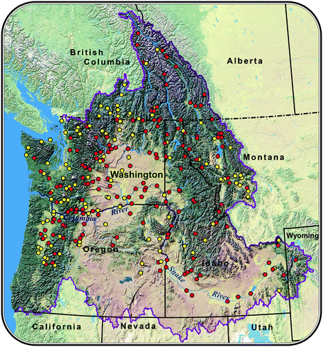
A primary motivation for the study was to support planning at geographic scales ranging from relatively small river basins (e.g., planning studies in individual sub-basins, such as the Yakima or Okanagan basins) to main-stem planning studies for the CRB as a whole (e.g., planning studies for the Columbia River hydro system). To select an appropriate group of specific streamflow locations to include in the study to meet these diverse needs, the primary funding agencies for the study and several other key water management agencies in the region (MDNR, IDWR, USBR, and USACE) were asked to submit prioritized lists of streamflow locations. Many river locations that were submitted for consideration were at gauging locations supported by the USGS and ECAN, or at locations associated with important water resources monitoring needs (e.g., checkpoints for flood control, water supply, or environmental flows) or infrastructure (e.g., dams and diversion points). shows a map of the approximately 300 streamflow locations that were ultimately compiled from these lists for inclusion in the study (a spreadsheet listing these sites is available on the CBCCSP website (CIG, Citation2013a)). The smallest of these sub-basins is about 500 km2 (approximately fifteen 1/16 degree VIC cells), and the largest encompasses most of the CRB (approximately 620,000 km2 or about 18,800 VIC cells). About 15 sites in western Washington, outside the CRB, were also included in support of the 2009 WACCIA.
Fig. 1 Map of the selected streamflow locations supported by the CBCCSP. Red dots indicate sites that are essentially unimpaired by human use or for which there is estimated modified* or naturalized flow. Sites without modified or natural flow estimates are shown in yellow. (*Modified flows are essentially naturalized flows with a consistent level of consumptive demand for water supply subtracted for the entire time series.)
c Climate Change Scenarios, Selection of GCM Projections, and Downscaling Procedures
The SRES A1B and B1 GHG emissions scenarios (Nakićenović et al. Citation2000) were selected as the basis for the study because they provide a) a wide range of plausible outcomes while also reflecting some potential GHG mitigation by the end of the twenty-first century, and b) most of the approximately 20 GCM projections associated with the CMIP3 archived runs from both emission scenarios (Mote & Salathé, Citation2010). During the study (and afterwards), some stakeholders expressed interest in including less optimistic emissions scenarios (such as SRES A1FI), in order to better understand the implications of a potential “worst case” scenario. This extreme scenario, however, was only run by a few GCMs, which ultimately limits the ability to show consistent ranges of outcomes for each emissions scenario. Although not as extreme as A1FI, the high-end A2 scenario was archived by most GCMs and could have been used in the CBCCSP in place of the A1B scenario. The choice of the A1B scenario, however, was informed by the authors’ viewpoint that this scenario is an instructive and plausible scenario reflecting relatively little GHG mitigation until mid-century (similar to A2 until about 2050), followed by more effective GHG mitigation efforts in the second half of the twenty-first century as impacts intensify.
Three statistical downscaling approaches were selected or developed for the study:
| • | Composite Delta (CD): regional average projections compiled from 10 GCMs (Elsner et al., Citation2010) | ||||
| • | Bias Correction and Spatial Downscaling (BCSD): (Salathé, Citation2005; Salathé, Mote, & Wiley, Citation2007; Wood, Leung, Sridhar, & Lettenmaier, Citation2004; Wood, Maurer, Kumar, & Lettenmaier, Citation2002) | ||||
| • | Hybrid Delta (HD): (Hamlet et al., 2010a) | ||||
Each of these methods has its specific advantages and limitations (as discussed in detail in Hamlet et al., 2010a); however, the HD method combines several important strengths of the CD and BCSD methods and was developed specifically to support the prediction of daily hydrologic extremes (Hamlet et al., 2010a). The HD method was also selected as the basis for the main summary products derived for each river location (see description below), primarily because it was capable of providing good performance over the complete range of products produced by the CBCCSP (Hamlet et al., 2010a).
Ten GCM projections for the A1B scenario and nine projections for the B1 scenario () were selected based on a ranking of the GCMs reflecting the combined ability of each GCM to reproduce key features of PNW climate variability, including the seasonal cycle of precipitation, observed trends in temperature in the late twentieth century, bias in reproducing historical temperature and precipitation, and ability to capture key features of observed climate variability (spatial patterns of temperature, pressure, and precipitation) over the North Pacific (Mote & Salathé, Citation2010). For the BCSD runs (for which the ability to capture key elements of the region's climate variability is arguably even more important to the outcomes) the projections based on the seven highest ranked GCMs () were selected for each emissions scenario. For the CD and HD downscaling methods, which construct a 91-year time series for both historical and future time periods, three future time periods were selected: 2020s (2010–2039), 2040s (2030–2059), and 2080s (2070–2099). The BCSD runs are transient runs from 1950 to 2098 or 1950 to 2099 (depending on the GCM). summarizes the 77 future meteorological forcing datasets that were prepared for the study.
Table 1. Matrix of climate change projections included in the study. Numbers in the table show the number of GCM projections used for each downscaling approach and/or time period. (Note that data for the B1 emissions scenario were not available from one of the ten GCMs used as input to the HD and CD approaches.)
It is important to acknowledge that opinions differ on the utility or even possibility of improving ensembles of future projections based on the ability to simulate the past climate (e.g., Gleckler, Taylor, & Doutriaux, Citation2008). However, our goal in this case was not to reduce the range of uncertainty by selecting a smaller group of GCMs. Instead our primary goal was to encompass the approximate range of all available scenarios while reducing costs by downscaling projections from a subset of the larger group of 20 GCMs (Hamlet et al., 2010a). Thus, by selecting 10 GCM scenarios with good historical performance that also spanned the range of impacts, we effectively reduced the computational and storage requirements of the CBCCSP by approximately a factor of two.
d Macroscale Hydrologic Model Implementation and Calibration
The macroscale hydrologic model used in the CBCCSP is the VIC model (Cherkauer & Lettenmaier, Citation2003; Liang, Lettenmaier, Wood, & Burges, Citation1994) implemented at 1/16 degree resolution. The VIC model has been widely applied in climate change studies at both the regional scale (e.g., Christensen & Lettenmaier, Citation2007; Lettenmaier, Wood, Palmer, Wood, & Stakhiv, Citation1999; Maurer, Citation2007; Maurer & Duffy, Citation2005; Payne et al., Citation2004; Van Rheenen, Wood, Palmer, & Lettenmaier, Citation2004) and global scale (e.g., Adam, Hamlet, & Lettenmaier, Citation2009; Nijssen, O'Donnell, Hamlet, & Lettenmaier, Citation2001). Among its most useful features is the predominantly physical basis of the model, which largely avoids concerns about parameter stationarity in a changing climate. For climate change studies in the western United States where snow is an important element of the hydrologic cycle, the model's use of a sophisticated energy-balance snow model, which incorporates important effects on snow accumulation and melt associated with vegetation canopy (Andreadis, Storck, & Lettenmaier, Citation2009) has been a notable advantage. Using the VIC model, Mote, Hamlet, Clark, and Lettenmaier (Citation2005), Mote, Hamlet, and Salathé (Citation2008), for example, showed excellent reproduction of observed trends in 1 April SWE over both the PNW as a whole and over the Cascade Range in Oregon and Washington. Most of the fundamental details regarding the VIC implementation used in this study are covered by Elsner et al. (Citation2010). Here we will review a few important aspects of the basic implementation to help orient the reader and will then focus most of our attention on the additional implementation and calibration tasks carried out during the CBCCSP.
The VIC model (version 4.0.7) was implemented at 1/16 degree resolution, with three active soil layers and up to five elevation bands with an approximate spacing of 500 m. The model was run in water balance mode with a snow model time step of 1 h and a water balance time step of 24 h. The model was coupled to a simple daily-time-step routing model (Lohmann, Raschke, Nijssen, & Lettenmaier, Citation1998), which was used to produce daily flow estimates at each of the approximately 300 streamflow locations included in the study. The VIC implementations make use of preprocessed soil and vegetation databases for the basin of interest. During initial model development steps, Elsner et al. (Citation2010) interpolated existing 1/8 degree model parameters to 1/16 degree and also included previously calibrated soil parameters for the Yakima sub-basin (please see acknowledgements). Elsner et al. (Citation2010) also updated the soil depth map using a more sophisticated approach developed for the DHSVM (Wigmosta, Nijssen, Storck, & Lettenmaier, Citation2002; Wigmosta, Vail, & Lettenmaier, Citation1994) that varies soil depth with elevation. Starting from these parameter sets, an additional large-scale calibration was performed during the CBCCSP to improve model performance in reproducing historical streamflow.
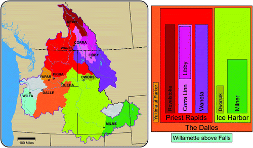
The strategy for model calibration used in the CBCCSP was to calibrate 11 relatively large sub-basins within the domain (), for which overall errors in meteorological driving data were assumed to be relatively small; then, using these model parameters, to check the results in smaller sub-catchments. This approach was partly based on practical limitations on time and computational resources but was also informed by previous experience using the VIC model at finer spatial scales. In relatively small basins (approximately 500–1500 km2), of which there are a substantial number included in the study, errors in meteorological driving data are often a strong determinant of simulation errors. Fine-scale calibration of the model to compensate for such errors, although technically feasible, is of questionable utility, because it essentially ensures that the model is getting something closer to the right answer for the wrong reasons, which in turn has the potential to distort the sensitivity of the model to changing future conditions (Bennett, Werner, & Schnorbus, Citation2012).
Fig. 2 Eleven sub-basins in the CRB used for large scale calibration (left panel). REVEL = Columbia River at Revelstoke Dam, CORRA = Kootenay River at Corra Linn Dam, WANET = Pend Oreille River at Waneta Dam, LIBBY = Kootenai (Kootenay) River at Libby Dam, DWORS = N. Fork Clearwater River at Dworshak Dam, MILNE = Snake River at Milner, ICEHA = Snake River at Ice Harbor Dam, PRIRA = Columbia River at Priest Rapids Dam, YAPAR = Yakima River at Parker, DALLE = Columbia River at The Dalles, OR, WILFA = Willamette River above falls at Oregon City. A number of sub-basins are nested within each other, as shown in the right panel along with their relative sizes. (For example, Dworshak and Milner are nested within the larger Ice Harbor sub-basin.).
Because of a general lack of observed naturalized daily time-step flow for most streamflow sites, daily time step calibration using additional parameters such as the infiltration parameter (bi ) in VIC (Liang et al., Citation1994), or routing parameters (such as the unit hydrograph for each cell) were not attempted during the study. A subsequent study in the Skagit River basin (Lee and Hamlet, unpublished manuscript) has demonstrated that substantial improvements in the simulation of high flow extremes can be achieved by calibrating the routing model, but it is not yet clear whether these conclusions can be generalized to other areas of the domain.
Three base flow parameters (Ds max, Ds, Ws) associated with the non-linear baseflow curve from the third soil layer (Liang et al., Citation1994) were used to calibrate the model. The highest value of baseflow is Ds max (in millimetres of runoff per time step) for a saturated soil layer; Ws represents the soil moisture threshold below which the baseflow curve is linear; and Ds is the baseflow value (in millimetres) at this breakpoint. These parameters were chosen because they strongly affect the timing and volume of runoff production in the model simulations and are, in general, not available from observed data.
Naturalized or modified flow data were available at a number of locations in the PNW. These data were compiled from naturalization studies prepared for the BPA (Crook, Citation1993), WDOE (Flightner, Citation2008), OWRD (Cooper, Citation2002), IDWR, and the USBR. In addition, some observed streamflow data are suitable for use as “natural” data if the effects of storage and diversions are relatively small (e.g., for the USGS Hydro-Climatic Data Network streamflow sites). Naturalized streamflow data were used exclusively in the CBCCSP to calibrate the hydrologic model. Naturalized and modified streamflow data were used to produce bias-corrected streamflow realizations (see below).
Calibration of the VIC model was carried out using an automated calibration tool called MOCOM-UA developed by the Land Surface Hydrology group at the UW, following the approach described by Yapo, Gupta, and Sorooshian (Citation1998). The process was also significantly improved by researchers at PCIC who reconfigured and optimized the code to run more efficiently on a Linux cluster (Schnorbus, Bennett, Werner, & Berland, Citation2011). The MOCOM-UA tool uses an objective function (defined by the user) and a shuffle complex evolution procedure to optimize model calibration parameters to create a set of Pareto (equally) optimal calibration parameters. We used 50 parameter sets to define the initial optimization parameter space, of which the 25 best parameter sets advance in each evolution of the optimization. Three VIC model calibration parameters described above were varied in the optimization process, and six error metrics were used to define the objective function: squared correlation coefficient (R 2), NSE, the NSE of log-transformed data, annual volume error, mean hydrograph peak difference, RMSE, and number of sign changes in the simulated streamflow errors.
The objective function for the optimization process in this case was:
Model calibration and validation used a split sample approach in which calibration was performed for each of the 11 primary watersheds over a 15-year period (typically water years 1975–1989) and model validation was performed over a separate 15-year period (typically water years 1960–1974). Both calibration and validation periods were chosen to test model performance over a wide range of climate and streamflow conditions. The two time periods also represent very different patterns of decadal climate variability in the historical record, providing a useful test in the context of simulating a changing climate.
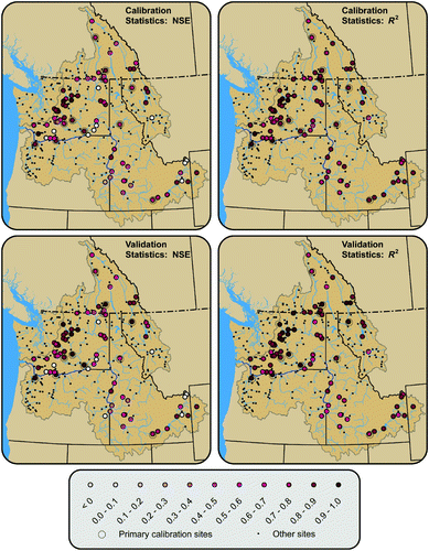
Final calibration results for the model are shown in . The model shows reasonably good calibration statistics for the majority of the sites, and the calibration is robust (showing equally good or better statistics in the validation period when compared with the calibration period). About 50 of the 80 sites evaluated show monthly NSE scores greater than or equal to approximately 0.7 (good to excellent fit). The NSE scores for about 20 sites are marginal (between 0.3 and 0.7). About 10 locations show negative NSE scores, which usually occurs when the simulations are strongly biased in comparison with observations. This diagnosis is confirmed by the R 2 values for the same sites, which are generally higher and more consistent with neighbouring values over the entire domain. In other words, although at these sites the model results do not match the observations in the absolute sense (large bias), the relative changes follow the observed variations quite well (high R 2). Strong bias in the simulations is commonly caused by precipitation errors (too much or too little annual precipitation), or in some cases by substantial errors in base flows because of contributions from groundwater in the actual system, which are not simulated by the VIC model (Wenger, Luce, Hamlet, Isaak, & Neville, Citation2010).
Fig. 3 Summary map of 80 streamflow locations (out of a total of 297) for which error statistics between simulated and naturalized flows were computed. The top two panels show the Nash Sutcliffe Efficiency (NSE) (left) and R 2 (right) for the calibration period, while the two lower panels show NSE (left) and R 2 (right) for the validation period. Small black dots indicate streamflow sites where naturalized flows were not available.
To explore how much the model simulations might be improved by additional fine-scale calibration, we also recalibrated three additional smaller sites within the Pend Oreille River basin. The results were only slightly better than those achieved in the large-scale calibration. Although results could potentially vary in different areas of the model domain, these results support the hypothesis that only modest improvements in validation statistics would result from individual calibration of additional streamflow sites within each sub-basin.
e Fine-Scale Hydrologic Modelling
The CBCCSP also included fine-scale hydrologic modelling using DHSVM (Wigmosta et al., Citation1994, Citation2002) in four pilot watersheds in the PNW. Because of space limitations, we will not be able to cover these alternative modelling efforts in this paper. The interested reader is directed to the CBCCSP report (Hamlet, Carrasco, et al., Citation2010a, Chapter 6) for a detailed discussion of methods and results.
f Model Output Variables
Twenty-one daily time-step output variables were archived for the VIC simulations (). These include the full meteorological forcings for the model (variables 1–8), a suite of water balance variables simulated by the model (variables 9–16), and five different PET metrics (variables 17–21) (Elsner et al., Citation2010).
Table 2. Archived daily VIC hydrologic model output variables. The variables are displayed in the order that they are archived in the VIC output files. The far right column shows the method used to aggregate daily output to monthly values for each variable.
g Model Post Processing
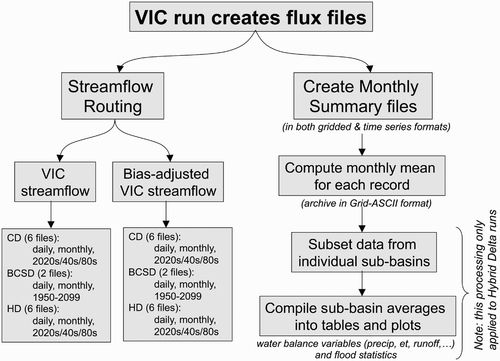
Post-processing of the primary VIC model output (see ) was carried out to produce a number of specific products discussed in the following sections. shows a flow chart of these post-processing steps.
Fig. 4 Flow chart illustrating the post-processing steps used to produce the various hydrologic products served on the study website.
Daily and monthly streamflow for each streamflow site are provided in two formats: a) raw VIC simulations, and b) bias-adjusted simulations. To produce the bias-adjusted flows, a bias correction procedure using quantile mapping techniques is applied (Elsner et al., Citation2010; Snover et al., Citation2003; Vano et al., Citation2010). These techniques remove systematic biases in the simulations of routed streamflow to produce products that closely match the long-term statistics of a natural or modified flow dataset for a particular site. The bias-corrected monthly values are then used to rescale the simulated daily flow sequences produced by the hydrologic model to produce bias-corrected daily streamflows. This daily disaggregation technique sometimes introduces an undesirable discontinuity in the bias-corrected daily values at the beginning and end of months. To minimize this data processing artifact, boundaries between months were smoothed while keeping the sum of daily streamflows equal to the original monthly values in the final product.
Bias-corrected streamflow values are useful in water planning studies, especially for providing inputs to reservoir operations models that are calibrated on a particular naturalized or modified flow dataset (e.g., Hamlet, Lee, et al., Citation2010b; NWPCC, Citation2005; Vano et al., Citation2010). These approaches are also useful for avoiding biases in the streamflow simulations that result from systematic errors in gridded precipitation or temperature data. As noted above, such errors are commonly encountered at relatively small spatial scales, particularly when meteorological stations are sparse, and often cannot be resolved using conventional hydrologic model calibration strategies. Bias-correction procedures provide an alternative statistical approach that effectively avoids these difficulties (Shi, Wood, & Lettenmaier, Citation2008; Snover et al., Citation2003).
Either naturalized or modified flows (Crook, Citation1993) are used for bias correction of data provided in the site-specific products discussed below, with naturalized data taking precedence if available. Thus, each site is bias-corrected using either naturalized or modified flow but not both. If neither naturalized nor modified flow is available, no bias-adjusted data were provided. Bias adjustment was also used in preparing the specific reservoir modelling support products discussed below. In this case only modified flows (2000-level modified flows obtained from the BPA (Crook, Citation1993)) were used to train the bias-correction procedure, even if naturalized flows were also available.
h Calculation of Extreme Event Statistics
Extreme event statistics are calculated directly from the raw (i.e., not bias-adjusted) daily streamflows at each streamflow site, applying methods developed by Hamlet and Lettenmaier (Citation2007) and Mantua et al. (Citation2010) over the entire PNW (Tohver et al. unpublished manuscript). The methods are discussed in more detail in these references, but a brief description of the procedure is given here to help orient the reader. Daily streamflow data from the CD and HD downscaling methods are first processed to extract the peak daily flow in each water year of the simulations (91 years). These annual peak daily flows are then ranked and assigned a quantile value using an unbiased quantile estimator based on the method of Cunane (Stedinger, Vogel, & Foufoula-Georgiou, Citation1993). After fitting three-parameter generalized extreme value probability distributions to the annual peak flow data, the daily 20-, 50-, and 100-year floods (under natural flow conditions) are estimated for both historical and future periods. The same procedure is followed for estimating extreme low flows, except the lowest 7-day flow is extracted for each water year, and 7Q10 (the extreme 7-day low flow with a return interval of 10 years) is estimated. These data are summarized in figures and tables prepared for each streamflow site discussed in Section 4. Regional summaries were prepared by Tohver et al. (unpublished manuscript).
4 Overview of key products
a Site Specific Data
For each streamflow location (and its associated contributing basin area), a set of identical products is available on the study web site (CIG, Citation2013b).
| • | Basin topographic map and smoothed basin boundary at 1/16 degree resolution. | ||||
| • | Summary information and statistics: geographic location, basin area, calibration statistics (if available), links to the USGS or ECAN websites, and so forth. | ||||
| • | Daily and monthly average streamflow for all projections listed in and, where possible, daily and monthly bias-corrected streamflow values. | ||||
| • | Figures and summary tables for long-term average monthly precipitation, monthly average temperature, evapotranspiration, PET4 (), PET5 (), total column soil moisture, SWE, combined flow (runoff + baseflow). These products are based solely on the HD projections listed in . | ||||
| • | Figures and summary tables for flood statistics and low-flow statistics. These products are based solely on the CD and HD projections listed in . | ||||
Note that unlike the raw VIC flux files discussed above (), imperial units are used for these products on the study website (cubic feet per second, inches, degrees Fahrenheit). This choice was imposed by WDOE. Here, however, we show the same figures in metric units.
b Site Specific Summary Figures
The summary figures for water balance variables at each site have the same format, two examples of which are shown in . Each of the six panels in the figure shows the long-term monthly mean for the 10 (9 for B1) HD GCM scenarios (red lines) and the historical simulations (blue lines). For the future scenarios, the range of the projections (pink shading) is plotted. The six panels display results from the combination of three time periods (rows) and two emissions scenarios (columns) used in the HD downscaling process. Text files (six per figure) providing all the ensemble data used to construct each panel in the figure are also provided on the CBCCSP website. Statistics for hydrologic extreme events (as discussed above) are presented in a different format, shown in .
Fig. 5 Examples of summary plots for monthly snow water equivalent (SWE) (mm) (averaged over the upstream basin area) and raw streamflow not adjusted for bias (cubic metres per second) for the Skagit River at Mount Vernon. Blue traces show monthly averages for historical conditions; the pink bands show the range of projected change associated with each scenario and future time period; the red lines show the average of the future ensemble.
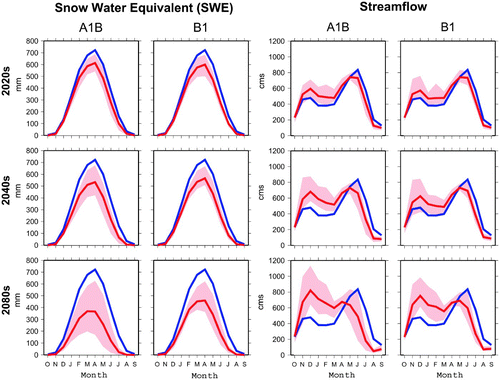
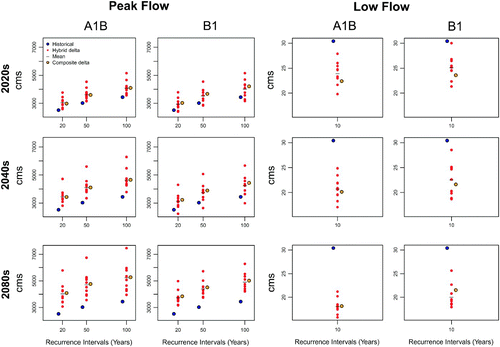
Fig. 6 Example of a summary plot for extreme high flows (Q20, Q50, Q100, left panels) and extreme low flows (7Q10, right panels) for the Skagit River at Mount Vernon for two emissions scenarios (A1B, B1) and three future time periods (2020s, 2040s, 2080s). Blue dots represent the historical values; the red dots show the range of values from the HD ensemble (10 or 9 values); black dashes show the mean of the HD ensemble, and the orange dots show the single value calculated for the CD projections.
c Gridded Datasets
Gridded datasets provide full spatial coverage (i.e., all grid cells in the model domain) at monthly time scales, of the key hydroclimatic variables listed in . Each product is provided as a gridded file (one file for each variable and calendar month) in ASCII format. In addition to the time series gridded data, the long-term monthly mean data for each hydrologic variable, for each scenario, is provided in GridASCII format, compatible with ArcGIS. These products are available for all 77 climate scenarios listed in , as well as for the historical simulation.
d Reservoir Model Inputs
Bias corrected inflows were produced to support the GENESYS and HYDSIM reservoir operations models, which are used by the NWPCC and BPA, respectively, for main-stem studies in the CRB (e.g., NWPCC, Citation2005). Naturalized flow products from specific sites were also used to provide naturalized inflows at model nodes needed to run the USBR MODSIM (Labadie, Citation2007) reservoir model for the Snake River basin.
5 Summary of key results
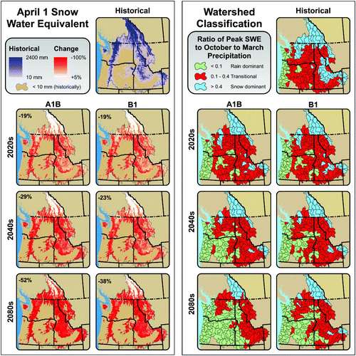
Changes in snowpack are a key driver of hydrologic impacts in the PNW (Elsner et al., Citation2010; Hamlet & Lettenmaier, Citation1999b). Confirming the sensitivity to warming demonstrated in earlier studies, the CBCCSP results show widespread reductions in the 1 April snowpack, and systematic reductions in the long-term average SWE2PR, a measure of the importance of snow in the hydrologic cycle (). Changes in the 1 April snowpack have been shown to depend strongly on winter temperature regimes (Hamlet, Mote, Clark, & Lettenmaier, Citation2005; Mote, Citation2006; Mote et al., Citation2005). As a result the largest changes in snowpack are apparent in the simulations for relatively warm coastal mountain ranges, such as the Cascade Range, and at moderate elevation in the Rockies, where snowpack is most sensitive to changes in temperature of a few degrees Celsius. Note the relative insensitivity of SWE to warming in the coldest, and most heavily snowmelt-dominant, areas in the northern tip of the CRB in British Columbia in comparison with the rest of the domain. These areas are so cold in winter (DJF average on the order of -10°C temperature) that a change in temperatures of 2°–3°C has relatively little effect on seasonal snow accumulation in the 2020s and 2040s. Instead, these areas respond primarily to projected changes in precipitation until late in the twenty-first century, and in fact some of these areas show modest increases in SWE (about +5%) until the middle of the twenty-first century under the combined effects of warming and increasing cool season precipitation. The same basic effects are seen in the SWE2PR maps, where snowmelt remains dominant in the northern tip of the CRB even at the end of the twenty-first century, whereas in the US portions of the domain there are widespread transformations of mixed-rain-and-snow river basins to rain-dominant basins and snowmelt-dominant basins to mixed-rain-and-snow basins. The changes in the importance of snow in some areas of the United States are particularly striking. The state of Oregon, for example, is classified as about 75% mixed-rain-and-snow for the twentieth century climate. By the end of the twenty-first century, essentially the entire state is classified as rain-dominant for the A1B scenario, and the B1 scenario is only slightly different (). These results point to extensive, landscape-scale transformations in hydrologic behaviour associated with climate change.
Fig. 7 Left panel: Simulated historical 1 April snow water equivalent (SWE) (upper right) and percentage changes in 1 April SWE for two emissions scenarios and three future time periods extracted from the CD VIC scenarios. Inset numbers at the upper left in the future projections are the percentage changes in 1 April SWE averaged over each grid cell in the entire domain. Right panel: Historical and projected future watershed classification (rain-dominant, transitional (mixed-rain-and-snow), snow-dominant) for 10-digit Hydrologic Unit Code watersheds, based on the long-term mean of the SWE2PR for each watershed. (1 April SWE and SWE2PR values were calculated using the CD VIC scenarios.)
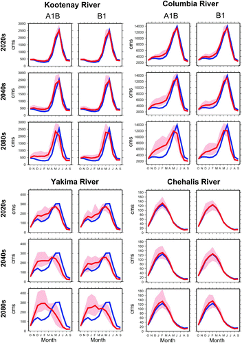
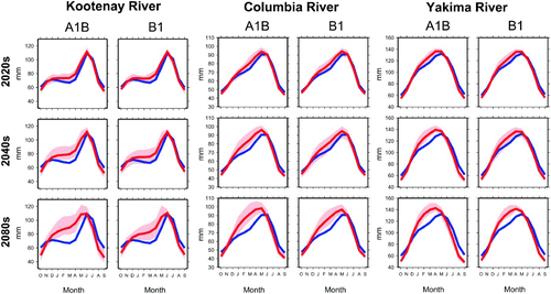
Monthly hydrographs in different portions of the domain primarily reflect changes in snow accumulation and melt processes and seasonal changes in precipitation (generally wetter falls, winters, and springs and drier summers). shows hydrographs from selected basins with different hydrologic classifications (snowmelt-dominant, mixed-rain-and-snow, and rain-dominant) in the United States and Canada. The site at Corra Linn Dam on the Kootenay River is representative of changing hydrographs in many locations in the northern tip of the CRB in British Columbia. Peak flows actually increase at many sites in Canada because of increasing fall, winter, and spring precipitation in this part of the domain, although the peak flow also occurs about a month earlier. Snowmelt-dominant basins in the United States, which are somewhat warmer and do not experience as much precipitation change in the scenarios, show increases in winter flow, earlier and reduced peak flow in spring, followed by an earlier streamflow recession and lower flows in late summer (e.g., Columbia River at The Dalles in ). The most sensitive basins are mixed-rain-and-snow basins. These basins experience dramatic losses of snowpack and substantial changes in seasonal flow timing (; Yakima River at Parker in ). Rain-dominant basins in the United States (e.g., Chehalis River at Grand Mound in ) experience little change in the shape of the monthly hydrograph because there is only occasional low-elevation snow in mid-winter in the twentieth century base case; therefore, there is relatively little sensitivity of monthly runoff timing to warming.
Fig. 8 Monthly mean hydrographs not adjusted for bias (water year: October–September) for four representative river sites in the PNW: Kootenay River at Corra Linn Dam (upper left), Columbia River at The Dalles, Oregon (upper right), Yakima River at Parker (lower left), and the Chehalis River at Grand Mound (lower right). Blue lines show the average historical values (1916–2006) (repeated in each panel). Pink bands show the range of nine or ten HD climate change scenarios for B1 and A1B emissions scenarios for three future time periods. Dark red lines show the average of the climate change ensemble.
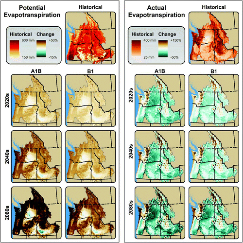
Changes in PET (PET3, see ) and AET (see ) are shown in . The PET is shown to increase dramatically over most of the domain (primarily because of warming in the scenarios), whereas AET shows widespread declines east of the Cascade Range. However, some areas west of the Cascade Range and in the northern Rockies show increasing AET. These spatial variations in the change in AET are broadly reflective of the dominant drivers of AET in each case. In relatively wet and cool areas along the coast and at high elevation in the northern parts of the basin, summer AET is energy limited; therefore, rising temperatures result in increases in AET. In much of the CRB, however, summer AET is water limited (i.e., there is abundant surface energy to evaporate whatever water is available), and changes in AET are dominated by decreasing summer precipitation in the scenarios, which effectively decreases summer AET in most cases.
Fig. 9 Left panel: Historical estimates of summer (JJA) potential evapotranspiration (PET) (based on PET3, see ) (upper right) compared with percentage changes in PET for two emissions scenarios and three future time periods from the CD scenarios. Right panel: Historical estimates of summer AET (upper right) compared with percentage changes for the same CD scenarios.
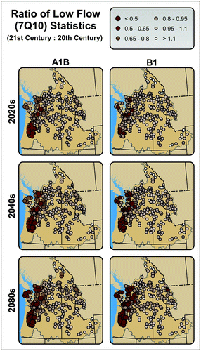
The magnitude of hydrologic extremes such as Q100 and 7Q10 are expected to shift markedly in some basins in response to cool season warming, increasing cool season precipitation, and warmer, drier summers. shows a map of Q100 ratios (future Q100 to historical Q100) for 297 river locations and a scatterplot of the Q100 ratio as a function of winter temperature regime in each basin. Rain dominant basins (DJF temperatures greater than 2°C) show moderate increases in flood risk (primarily reflecting increasing storm intensity in the simulations), whereas snowmelt-dominant basins that currently flood in June show relatively little change in flood risk. The largest changes in flood risk are simulated in mixed-rain-and-snow basins. Flooding in these basins is sensitive to both warming (which raises snow lines and effectively enlarges the contributing basin area during most flood events) and increasing winter precipitation. Because both these effects increase flood risk in the simulations, the effects are unusually large in these basins (). Increasing low flow risks (declining 7Q10 values) are widespread across the domain as a result of the combined effects of declining snowpack (which tends to result in earlier streamflow recession and lower flows in late summer, see ) and warmer and drier summers (which increase PET) (). The largest reductions in low flows occur west of the Cascade Range in the simulations. This is likely because soil moisture is higher in summer west of the Cascade Range and evapotranspiration is mostly energy limited, whereas east of the mountains the late summer soil moisture is already very low in the current climate and increasing evapotranspiration does not result in much additional soil moisture stress. In other words, dry areas east of the Cascade Range have less base-flow potential to lose with increasing evapotranspiration and loss of summer precipitation because the soil moisture is already at very low levels in late summer. Tague, Grant, Farrell, Choate and Jefferson (Citation2008) showed analogous differences between watersheds in the PNW based on the relative contribution of groundwater to base flows. We should note that glaciers and “deep” groundwater (e.g., contributions to streamflow from large confined aquifers) are not simulated by the VIC model, and impacts in areas profoundly influenced by these hydrologic features may not be well characterized in the simulations (Wenger et al., Citation2010). Broad changes in “shallow” groundwater (e.g., localized contributions to streamflow from smaller unconfined aquifers), however, are likely well captured by the VIC model based on a strong correlation between VIC-simulated base flows and observations in many basins examined by Wenger et al. (Citation2010).
Fig. 10 Left panel: Changes in Q100 for 297 streamflow locations expressed as a ratio of Q100 for the future period to Q100 for the historical period based on the average of the nine or ten HD scenarios for the B1 and A1B emissions scenarios for three future time periods. Right panel: Same data shown as a scatter plot of the average ratio of Q100 for the 2040s A1B scenarios to Q100 for the historical period versus historical basin-average mid-winter (DJF) temperature in each case. Typical month of historical flooding events is shown by the colour of the dots in the scatter plot (legend inset in the upper right corner), by permission of I. Tohver, A.F. Hamlet, and S.-Y. Lee.
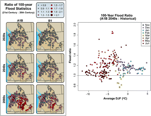
Fig. 11 Changes in 7Q10 for 297 river locations expressed as a ratio of 7Q10 for the future period to 7Q10 for the historical period based on the average of the nine or ten HD scenarios for the B1 and A1B emissions scenarios for three future time periods, by permission of I. Tohver, A.F. Hamlet, and S.-Y. Lee.
Other impacts, such as changes in soil moisture dynamics are also apparent in the simulations. In most basins with substantial snowpack, elevated soil moisture in winter accompanies warming in the simulations resulting from more infiltration from rain in the fall and winter months (). These results support the hypothesis that widespread increases in winter landslide risks and sediment transport in rivers are likely to accompany increased winter precipitation and loss of interannual snowpack in mountain watersheds.
Fig. 12 Changes in monthly mean total column soil moisture (October–September) for three representative river sites in the PNW: Kootenay River at Corra Linn Dam (left), Columbia River at The Dalles, Oregon (centre), and Yakima River at Parker (right). Blue lines show average historical values (1916–2006) (repeated in each panel). Pink bands show the range of nine or ten HD climate change scenarios for B1 and A1B emissions scenarios for three future time periods. The dark red lines show the average of the climate change ensemble.
Differences in the impacts in the US and Canadian portions of the basin are striking, confirming results reported in two previous studies (Hamlet, Citation2003; Hamlet & Lettenmaier, Citation1999b). Reductions in spring snowpack and summer streamflow, for example, are relatively modest in the Canadian portions of the basin because of cold winter temperatures that delay warming-related impacts to seasonal snowpack (Elsner et al., Citation2010). Corresponding shifts in the seasonal timing of streamflow are also relatively small in the Canadian CRB until late in the twenty-first century. Based on these substantial differences in hydrologic impacts it is difficult to escape the conclusion that management of water resources in the Canadian portions of the basin will play a crucial role in the ability of US water managers to adapt to more substantial changes in streamflow timing and summer low flows in the United States. In particular, it is clear that Canada will have not only about 50% of the reservoir storage in the CRB (Hamlet, Citation2003) but also an increasingly dominant portion of the natural water storage as snowpack in the future. The presence of glaciers in Canada (not included in the CBCCSP simulations) may further exacerbate the discrepancies between impacts to summer flows in the United States and Canada in late summer (Werner et al., Citation2013).
6 Use of products and information by stakeholders, water professionals, and researchers
The CBCCSP was designed from the outset to support users with a very wide range of technical sophistication and capacity. For example, to support academic or agency researchers with their own hydrologic modelling capability, the study provides projections of meteorological drivers such as temperature, precipitation, solar radiation, and humidity and a calibrated VIC hydrologic model implementation. Using these resources, other modelling groups can carry out their own investigations of hydrologic impacts using either their own hydrologic model (just using the driving data) or the VIC implementation from the CBCCSP. At the other extreme, for those without any hydrologic modelling or post-processing capability the study provides a wide range of hydrologic products that can be used without any expertise in the preceding steps. Intermediate products are available as well, which can be used by people with GIS capabilities, but with little or no knowledge of climate projections and hydrologic modelling. Thus, depending on their needs and level of technical sophistication, stakeholders can make the best use of the study products by extracting information at different points in the data processing sequence, all of which are available on the study web site. Similarly, three different downscaling approaches were used in the study, each with its own advantages and limitations in the context of different natural resources management applications (Hamlet et al., 2010a). Thus, stakeholders can select different products, using different downscaling approaches that are appropriate to their needs. As noted above, the study also supports planning efforts over a wide range of geographic scales.
A number of high-visibility studies have made use of the CBCCSP database to date, a few of which are summarized below.
a Columbia River Management Joint Operating Committee (RMJOC) Studies
The primary activities and objectives of the RMJOC studies are described in the Executive Summary of the project report (US Department of the Interior, Citation2012):
The Bonneville Power Administration (BPA), U.S. Army Corps of Engineers (USACE), and U.S. Bureau of Reclamation (Reclamation) collaborated to adopt climate change and hydrology datasets for their longer-term planning activities in the Columbia–Snake River Basin (CSRB). This was coordinated through the River Management Joint Operating Committee (RMJOC), a sub-committee of the Joint Operating Committee which was established through direct funding Memorandum of Agreements between BPA, Reclamation, and the USACE. The RMJOC is specifically dedicated to reviewing the practices, procedures, and processes of each agency to identify changes that could improve the overall efficiency of the operation and management of the Federal Columbia River Power System projects.
In addition to creating these datasets, the RMJOC agencies worked together to adopt a set of methods for incorporating these data into those longer-term planning activities.
Although a number of pilot climate change studies have been carried out in the CRB in collaboration with various water management agencies in the past (e.g., NWPCC, Citation2005), the RMJOC study was something of a landmark in that it was the first time that the BPA, USBR, and USACE used climate change information in coordinated interagency planning exercises in the CRB. The study was also unique in that this was the first time that these agencies had run their own reservoir operation models to assess climate change impacts in the CRB, an element of the study design which greatly increased the impact of the study conclusions in the agencies involved.
b Washington State University (WSU) Crop Water Demand and Water Supply Studies under HB2860
As mentioned in the introduction, WA HB2860, which provided the bulk of the funding for the CBCCSP, also charged WDOE with identifying where US$200 million earmarked for water resources infrastructure improvements should be spent. Funding was received by WSU to carry out research quantifying crop water demand, water resources system performance, and economic impacts under current climate conditions and a range of future climate scenarios. The CBCCSP provided climate change projections of meteorological drivers and a calibrated VIC implementation in support of the study. The calibrated CBCCSP VIC model was modified by WSU by integrating it with a sophisticated crop model (CropSyst; Stöckle, Donatelli, & Nelson, Citation2003) that, among other functions, estimates crop water demand. The study also used the ColSim reservoir operations model (Hamlet & Lettenmaier, Citation1999b) to estimate water deliveries to the Columbia Basin Project (the primary irrigation project supplied by water from Grand Coulee Dam) under future climate scenarios using streamflows generated by the integrated VIC/CropSyst model. A set of simpler, lumped-storage reservoir operations models was used to quantify impacts in a number of smaller water supply systems. These hydrologic studies support detailed assessment of the economic impacts of climate change on irrigation and important crops in WA (Yorgey et al., Citation2011), which in turn will inform decisions regarding best use of funding to improve water supply benefits in WA under climate change. This study represents one of the first attempts to dynamically couple a sophisticated, physically based hydrologic model with a detailed crop model to estimate the integrated impacts on water supply and crop viability at a range of spatial scales.
c Washington State (WA) Integrated Climate Change Response Strategy
Following the WACCIA in 2009, the WA Legislature, via the Act relating to State Agency Climate Leadership (2009), charged WDOE and other state agencies with preparing a first climate change adaptation plan for WA. Impacts assessments from the WACCIA played a central role in these planning activities, but updated and extended data from the CBCCSP also materially supported these efforts. The CBCCSP, in particular, provided access to additional scenarios and downscaling methods that provided a range of hydrologic outcomes associated with uncertainty in the climate projections, which the WACCIA assessments largely did not. The CBCCSP also provided a more thorough assessment of hydrologic extremes via the HD scenarios, providing ranges of these values that were more geographically specific as opposed to an estimate of the central tendency from the CD approaches used in the WACCIA. Although results from the WACCIA would arguably have been adequate to support WDOE's adaptation planning, the CBCCSP provided additional foundation support for these efforts, and helped improve confidence in the outcomes of the adaptation strategies identified by better quantifying a range of outcomes.
d West-Wide Extensions to Support USFS and USFWS Needs
Over the last several years, the USFS and USFWS have engaged with the CIG to produce a set of initial climate change hydrologic scenarios over much of the west using a common methodology intended to support landscape-scale assessment of climate change impacts (Littell et al., Citation2011). Using the VIC model, the study has projected impacts for the Great Busin and the Columbia River, Missouri River, and Colorado River basins, and assessment of impacts in California is underway at the time of writing. Although this project consists of an abbreviated set of scenarios and products using three scenarios (high, medium, and low impact) for one downscaling method, the CBCCSP played an important role in providing an established set of methods for developing historical driving datasets and implementing and running the hydrologic models. The CBCCSP also provided a complete and well-tested data processing sequence for post-processing and summarizing the hydrologic data to provide figures and analysis efficiently. The CBCCSP had a budget of about US$500 thousand (in 2010 dollars) over two years. West-wide studies to support USFS and USFWS needs (including current efforts to include California) will have a budget of less than half this amount, a level of efficiency that would not have been achievable without the CBCCSP pilot effort. The USFS and USFWS studies have supported a number of high-visibility ecosystem studies, including assessment of the impacts of changing snowpack on wolverine populations (McKelvey et al., Citation2011) and subsequent proposed ESA listing of wolverine populations, and comprehensive assessment of climate change impacts to trout species over the west (Wenger et al., Citation2011).
e Studies in Support of the Department of the Interior (DOI) Landscape Conservation Cooperatives and Regional Climate Science Centers
The DOI via the USFWS has recently established a set of LCCs across the United States (USFWS, Citation2013) and has generated additional funding to support a group of regional CSCs, one of which was recently established in the PNW (PNWCSC), combining the efforts of about 15 PNW research universities, jointly led by the USGS, Oregon State University, the UW, and the University of Idaho. Data from the CBCCSP are currently supporting two CIG studies funded by the LCCs and the CSC, including a study of impacts to wetlands in the PNW (funded by the North Pacific LCC and the PNWCSC) and a study assessing climatic and hydrologic extremes and their effects on ecosystems over the western United States (funded by the PNWCSC). The CBCCSP (and extensions over the west) has greatly reduced the costs of these types of studies by supplying (at essentially no cost) a wide range of high-quality hydrologic scenarios as a foundation for further work.
f Seattle City Light Case Study
A detailed climate change assessment report was prepared by the CIG for Seattle City Light (Snover et al., Citation2010) based primarily on the CBCCSP database. Additional streamflow sites were routed from the primary VIC data, and water temperature simulations for a number of additional sites were based on temperature projections from the study. This is a good example of the use of the study data to support relatively fine-scale planning needs.
7 Future Work
A key design element of the CBCCSP from the outset of the project was to produce a well-organized and well-documented “end-to-end” (i.e., GCM to hydrologic products) data processing sequence and a web-accessible data archive that would greatly reduce the cost of producing updates in response to each subsequent CMIP/IPCC cycle. Future work on the project will likely focus on expanding the number of streamflow sites for which products are available (e.g., inclusion of additional sites in coastal Oregon in the site-specific products) and providing a comprehensive suite of products associated with CMIP5 results (Taylor, Stouffer, & Meehl, Citation2012) associated with IPCC AR5.
8 Summary and conclusions
The CBCCSP was founded on the basis of regional partnerships to support a shared need for climate change scenarios and directly encompassed the transboundary nature of the CRB's management framework by including both US and Canadian interests in an integrated and comprehensive data resource. The study is intended to support research, vulnerability assessment, long-term planning, and climate change adaptation by the natural resources management community at a range of spatial scales, by users with varying levels of technical expertise.
The study employs a state-of-the-art, end-to-end data processing sequence that moves from raw GCM output to a set of final hydrological products that can be accessed by the user community from a web-accessible database. Key products from the study include detailed summary data for about 300 river sites in the PNW and monthly GIS products for 21 hydrologic variables over the entire study domain. Additional products such as bias-adjusted inflow sequences for specific reservoir operations models are also included.
Depending on their needs and/or level of technical sophistication, users can tap into the study databases at a number of different levels. For example, researchers who wish to run their own hydrologic models can do so by downloading the statistically downscaled meteorological forcings from the study. Those who lack their own hydrologic model, but wish to make additional runs themselves, can obtain the calibrated VIC model implementation. Those who wish to do additional post-processing of the existing VIC data can access the archived model output. Full knowledge of the preceding steps is not required to use the products obtained at any level of the study, which increases the utility of the products.
Results from the study show profound changes in spring snowpack and fundamental shifts from snow to rain-dominant behaviour across most of the domain. Associated shifts in streamflow timing from spring and summer to winter are also evident in basins that currently have significant snow accumulation in winter, whereas rain-dominant basins show minimal shifts in streamflow timing. The PET increases over most of the PNW in summer as a result of rising temperatures; however, AET is reduced in all but a few areas of the domain because AET is water limited and summer precipitation decreases in the simulations. Both floods (Q100) and extreme 7-day low flows (7Q10) increase in intensity for most of the river sites simulated. The largest increases in flooding are in mixed-rain-and-snow basins whose mid-winter temperatures are presently within a few degrees of freezing. Simulated widespread increases in soil moisture recharge in fall and winter in areas with significant snow accumulation in winter (for the current climate) support hypotheses of increased landslide risk and sediment transport in winter in the future.
The CBCCSP database has been a valuable resource which has dramatically reduced the cost of a number of high-visibility planning studies in the PNW, including the RMJOC water resources planning studies conducted by the BPA, USBR, and USACE, WSU integrated crop modelling and irrigation water demand studies under HB2860, the WA Integrated Climate Change Response Strategy, and west-wide extensions of the CBCCSP supported by the USFS and USFWS.
Acknowledgements
Primary support for the project was provided by WDOE, with additional major support provided by the BPA, NWPCC, BCME, OWRD, and CTED via the 2009 WACCIA (http://cses.washington.edu/cig/res/ia/waccia.shtml) (Miles et al., Citation2010).
Special thanks to Kurt Unger and Ken Slattery, who were the primary architects of the CBCCSP at WDOE. Thanks also to Nancy Stephan (BPA), John Fazio and Jim Ruff (NWPCC), Allan Chapman and Ben Kagasniemi (BCME), and Barry Norris (OWRD) for their contributions to the initial study design. Dave Rodenhuis, Markus Schnorbus, Arelia Werner, and Katrina Bennett at PCIC at the University of Victoria, British Columbia, also provided in-kind support and funding for collaborative research which contributed materially to this project. A number of regional partners provided recommendations for streamflow locations and other in-kind support including Jesse Abner (MDNR), Steve Running (University of Montana), Hal Anderson (IDWR) Levi Brekke, Pat McGrane and John Roache (USBR), Carolyn Fitzgerald (Seattle District USACE), Seshu Vaddey and Randy Wortman (Portland District USACE). Thanks to Shrad Shukla, at the UW for 1/16 degree VIC model calibration over the Yakima basin.
The authors would like to acknowledge the contributions of other members of the CBCCSP research team at the UW including Lara Whitely Binder, Pablo Carrasco, Jeffrey Deems, Carrie Lee, Dennis P. Lettenmaier, Tyler Kamstra, Jeremy Littell, Nathan Mantua, Edward Miles, Kristian Mickelson, Philip W. Mote, Erin Rogers, Eric Salathé, Amy Snover, and Andrew Wood.
Thanks to Sean Fleming (Environment Canada) for spearheading this contribution to Atmosphere-Ocean. The authors would like to acknowledge the contributions of two anonymous reviewers and the lead and associate editors for Atmosphere-Ocean, whose constructive suggestions substantially improved the paper during the review process.
Special thanks also to Dennis P. Lettenmaier, head of the Land Surface Hydrology Group at the UW, for providing access to computer resources and system administration support for the CBCCSP.
References
- Act relating to water resource management in the Columbia river basin, H.R. 2860, 59th Legislature (WA 2006).
- Act relating to state agency climate leadership, S. 5560, 61st Legislature (WA 2009).
- Adam , J. C. , Hamlet , A. F. and Lettenmaier , D. P. 2009 . Implications of global climate change for snowmelt hydrology in the 21st century . Hydrological Processes , 23 ( 7 ) : 962 – 972 . (doi:10.1002/hyp.7201)
- Andreadis , K. , Storck , P. and Lettenmaier , D. P. 2009 . Modeling snow accumulation and ablation processes in forested environments . Water Resources Research , 45 : W05429 doi:10.1029/2008WR007042 (doi:10.1029/2008WR007042)
- Battisti , D. S. and Sarachik , E. 1995 . Understanding and predicting ENSO . Reviews of Geophysics , 33 : 1367 – 1376 . (doi:10.1029/95RG00933)
- Bennett , K. E. , Werner , A. T. and Schnorbus , M. 2012 . Uncertainties in hydrologic and climate change impact analyses in headwater basins of British Columbia . Journal of Climate , 25 : 5711 – 5730 . doi:http://dx.doi.org/10.1175/JCLI-D-11-00417.1 (doi:10.1175/JCLI-D-11-00417.1)
- Casola, J. H., Kay, J. E., Snover, A. K., Norheim, R. A., Binder, L. C. W., & the Climate Impacts Group. (2005). Climate impacts on Washington's hydropower, water supply, forests, fish, and agriculture. A report prepared for King County (Washington). Climate Impacts Group (Center for Science in the Earth System, Joint Institute for the Study of the Atmosphere and Ocean, University of Washington, Seattle).
- Cherkauer , K. A. and Lettenmaier , D. P. 2003 . Simulation of spatial variability in snow and frozen soil . Journal of Geophysical Research , 108 ( D22 ) : 8858 doi:10.1029/2003JD003575 (doi:10.1029/2003JD003575)
- Christensen , N. and Lettenmaier , D. P. 2007 . A multi-model ensemble approach to assessment of climate change impacts on the hydrology and water resources of the Colorado River basin . Hydrology and Earth System Sciences , 11 : 1417 – 1434 . (doi:10.5194/hess-11-1417-2007)
- CIG (Climate Impacts Group). 2013a. Site specific data [Data]. Retrieved from http://warm.atmos.washington.edu/2860/products/sites/
- CIG (Climate Impacts Group). 2013b. Hydrologic climate change scenarios for the Pacific Northwest Columbia River basin and coastal drainages. Retrieved from http://warm.atmos.washington.edu/2860/
- Cohen , S. J. , Miller , K. , Hamlet , A. and Avis , W. 2000 . Climate change and resource management in the Columbia River Basin . Water International , 25 ( 2 ) : 253 – 272 . (doi:10.1080/02508060008686827)
- Cooper, R. M. (2002). Determining surface water availability in Oregon. Open File Report SW 02-002. Oregon Water Resources Department. Salem, Oregon.
- Crook, A. G. (1993). 1990 level modified streamflow 1928–1989. Contract # DE-AC79-92BP21985. Report of A.G. Crook Company to Bonneville Power Administration, Portland, OR.
- Daly , C. , Gibson , W. P. , Taylor , G. , Johnson , G. L. and Pasteris , P. 2002 . A knowledge-based approach to the statistical mapping of climate . Climate Research , 22 : 99 – 113 . (doi:10.3354/cr022099)
- Daly , C. , Neilson , R. P. and Phillips , D. L. 1994 . A statistical-topographic model for mapping climatological precipitation over mountainous terrain . Journal of Applied Meteorology , 33 : 140 – 158 . (doi:10.1175/1520-0450(1994)033<0140:ASTMFM>2.0.CO;2)
- DiLuzio , M. , Johnson , G. L. , Daly , C. , Eischeid , J. K. and Arnold , J. G. 2008 . Constructing retrospective gridded daily precipitation and temperature datasets for the conterminous United States . Journal of Applied Meteorology and Climatology , 47 : 475 – 497 . (doi:10.1175/2007JAMC1356.1)
- Elsner , M. M. , Cuo , L. , Voisin , N. , Deems , J. S. , Hamlet , A. F. , Vano , J. A. , Mickelson , K. E. B. , Lee , S. Y. and Lettenmaier , D. P. 2010 . Implications of 21st century climate change for the hydrology of Washington State . Climatic Change , 102 ( 1–2 ) : 225 – 260 . doi:10.1007/s10584-010-9855 (doi:10.1007/s10584-010-9855-0)
- Flightner, G. (2008). Natural streamflows: Columbia River tributaries in Washington, 1928–2006. Contract # C0700334, 28 March 2008. Report of Gary Flightner Engineering to Washington State Dept. of Ecology, Olympia WA.
- Gershunov , A. and Barnett , T. P. 1998 . Interdecadal modulation of ENSO teleconnections . Bulletin of the American Meteorological Society , 79 ( 12 ) : 2715 – 2725 . (doi:10.1175/1520-0477(1998)079<2715:IMOET>2.0.CO;2)
- Gleckler , P. J. , Taylor , K. E. and Doutriaux , C. 2008 . Performance metrics for climate models . Journal of Geophysical Research-Atmospheres , 113 ( D6 ) D06104. doi:10.1029/2007JD008972
- Hamlet , A. F. 2003 . “ The role of transboundary agreements in the Columbia River basin: An integrated assessment in the context of historic development, climate, and evolving water policy ” . In Climate and water: Transboundary challenges in the Americas , Edited by: Diaz , H. and Morehouse , B. 263 – 289 . Dordrecht/Boston/London : Kluwer Press .
- Hamlet , A. F. 2011 . Assessing water resources adaptive capacity to climate change impacts in the Pacific Northwest region of North America . Hydrology and Earth System Sciences , 15 : 1427 – 1443 . doi:10.5194/hess-15-1427-2011 (doi:10.5194/hess-15-1427-2011)
- Hamlet, A. F., Carrasco, P., Deems, J., Elsner, M. M., Kamstra, T., Lee, C., Lee, S-Y, Mauger, G., Salathe, E. P., Tohver, I., & Binder, L. W. (2010a). Final project report for the Columbia Basin Climate change scenarios project. Retrieved from http://warm.atmos.washington.edu/2860/report/
- Hamlet , A. F. , Huppert , D. and Lettenmaier , D. P. 2002 . Economic value of long-lead streamflow forecasts for Columbia River hydropower . ASCE Journal of Water Resources Planning and Management , 128 ( 2 ) : 91 – 101 . (doi:10.1061/(ASCE)0733-9496(2002)128:2(91))
- Hamlet , A. F. , Lee , S. Y. , Mickelson , K. E. B. and Elsner , M. M. 2010b . Effects of projected climate change on energy supply and demand in the Pacific Northwest and Washington State . Climatic Change , 102: doi:10.1007/s10584-010-9857-y
- Hamlet , A. F. and Lettenmaier , D. P. 1999a . Columbia River streamflow forecasting based on ENSO and PDO climate signals . ASCE Journal of Water Resources Planning and Management , 125 ( 6 ) : 333 – 341 . (doi:10.1061/(ASCE)0733-9496(1999)125:6(333))
- Hamlet , A. F. and Lettenmaier , D. P. 1999b . Effects of climate change on hydrology and water resources in the Columbia River basin . Journal of the American Water Resources Association , 35 ( 6 ) : 1597 – 1623 . (doi:10.1111/j.1752-1688.1999.tb04240.x)
- Hamlet , A. F. and Lettenmaier , D. P. 2000 . Long-range climate forecasting and its use for water management in the Pacific Northwest Region of North America . Journal of Hydroinformatics , 2 ( 3 ) : 163 – 182 .
- Hamlet , A. F. and Lettenmaier , D. P. 2005 . Production of temporally consistent gridded precipitation and temperature fields for the continental U.S . Journal of Hydrometeorology , 6 ( 3 ) : 330 – 336 . (doi:10.1175/JHM420.1)
- Hamlet , A. F. and Lettenmaier , D. P. 2007 . Effects of 20th century warming and climate variability on flood risk in the western U.S . Water Resources Research , 43 : W06427 doi:10.1029/2006WR005099 (doi:10.1029/2006WR005099)
- Hamlet , A. F. , Mote , P. W. , Clark , M. P. and Lettenmaier , D. P. 2005 . Effects of temperature and precipitation variability on snowpack trends in the western U.S . Journal of Climate , 18 ( 21 ) : 4545 – 4561 . (doi:10.1175/JCLI3538.1)
- Kalnay , E. , Kanamitsu , M. , Kistler , R. , Collins , W. , Deaven , D. , Gandin , L. , Iredell , M. , Saha , S. , White , G. , Woollen , J. , Zhu , Y. , Leetmaa , A. , Reynolds , R. , Chelliah , M. , Ebisuzaki , W. , Higgins , W. , Janowiak , J. , Mo , K. C. , Ropelewski , C. , Wang , J. , Jenne , R. and Joseph , D. 1996 . The NCEP/NCAR 40-year reanalysis project . Bulletin of the American Meteorological Society , 77 : 437 – 470 . (doi:10.1175/1520-0477(1996)077<0437:TNYRP>2.0.CO;2)
- Kimball , J. S. , Running , S. W. and Nemani , R. 1997 . An improved method for estimating surface humidity from daily minimum temperature . Agricultural and Forest Meteorology , 85 : 87 – 98 . (doi:10.1016/S0168-1923(96)02366-0)
- Labadie, J. W. (2007). MODSIM-DSS: River basin management Decision Support System. Retrieved from http://modsim.engr.colostate.edu/
- Lee , S.-Y. , Hamlet , A. F. , Fitzgerald , C. J. and Burges , S. J. 2009 . Optimized flood control in the Columbia River basin for a global warming scenario . ASCE Journal of Water Resources Planning and Management , 135 ( 6 ) : 440 – 450 . doi:10.1061/(ASCE)0733-9496 (doi:10.1061/(ASCE)0733-9496(2009)135:6(440))
- Lee , S.-Y. , Hamlet , A. F. , Fitzgerald , C. J. and Burges , S. J. 2011 . Methodology for developing flood rule curves conditioned on El Niño-Southern Oscillation classification . Journal of the American Water Resources Association , 47 ( 1 ) : 81 – 92 . doi:10.1111/j.1752-1688.2010. 00490.x (doi:10.1111/j.1752-1688.2010.00490.x)
- Lee , S.-Y. , Fitzgerald , C. J. , Hamlet , A. F. and Burges , S. J. 2011 . Daily time step refinement of optimized flood control rule curves for a global warming scenario . ASCE Journal of Water Resources Planning and Management , 137 ( 4 ) : 309 – 317 . doi:10.1061/(ASCE)WR.1943-5452.0000125 (doi:10.1061/(ASCE)WR.1943-5452.0000125)
- Lettenmaier , D. P. and Hamlet , A. F. 2003 . “ Improving water resources system performance through long-range climate forecasts: The Pacific Northwest experience (Chapter 7) ” . In Water and climate in the western United States , Edited by: Lewis , W. M. Jr. 107 – 122 . Boulder : University Press of Colorado .
- Lettenmaier , D. P. , Wood , A. W. , Palmer , R. N. , Wood , E. F. and Stakhiv , E. Z. 1999 . Water resources implications of global warming, a U.S. regional perspective . Climatic Change , 43 ( 3 ) : 537 – 579 . (doi:10.1023/A:1005448007910)
- Leung , L. R. , Hamlet , A. F. , Lettenmaier , D. P. and Kumar , A. 1999 . Simulations of the ENSO hydroclimate signals in the Pacific Northwest Columbia River basin . Bulletin of the American Meteorological Society , 80 ( 11 ) : 2313 – 2329 . (doi:10.1175/1520-0477(1999)080<2313:SOTEHS>2.0.CO;2)
- Liang , X. , Lettenmaier , D. P. , Wood , E. F. and Burges , S. J. 1994 . A simple hydrologically based model of land surface water and energy fluxes for general circulation models . Journal of Geophysical Research , 99 ( D7 ) : 14415 – 14428 . (doi:10.1029/94JD00483)
- Littell, J. S., Elsner, M. M., Mauger, G. S., Lutz, E. R., Hamlet, A. F., & Salathé, E. P. (2011). Regional climate and hydrologic change in the northern U.S. Rockies and Pacific Northwest: Internally consistent projections of future climate for resource management. Preliminary project report, USFS JVA 09-JV-11015600-039. Prepared by the Climate Impacts Group, University of Washington, Seattle. Retrieved from http://cses.washington.edu/picea/USFS/pub/Littell_etal_2010/Littell_etal._2011_Regional_Climatic_And_Hydrologic_Change_USFS_USFWS_JVA_17Apr11.pdf
- Littell , J. S. , Oneil , E. E. , McKenzie , D. , Hicke , J. A. , Lutz , J. A. , Norheim , R. A. and Elsner , M. M. 2010 . Forest ecosystems, disturbance, and climatic change in Washington State, USA . Climatic Change , 102 ( 1–2 ) : 129 – 158 . doi:10.1007/s10584-010-9858-x (doi:10.1007/s10584-010-9858-x)
- Lohmann , D. , Raschke , E. , Nijssen , B. and Lettenmaier , D. P. 1998 . Regional scale hydrology: I. Formulation of the VIC-2L model coupled to a routing model . Hydrological Sciences Journal , 43 : 131 – 141 . (doi:10.1080/02626669809492107)
- Mantua , N. , Hare , S. , Zhang , Y. , Wallace , J. M. and Francis , R. 1997 . A Pacific interdecadal climate oscillation with impacts on salmon production . Bulletin of the American Meteorological Society , 78 : 1069 – 1079 . (doi:10.1175/1520-0477(1997)078<1069:APICOW>2.0.CO;2)
- Mantua , N. , Tohver , I. and Hamlet , A. F. 2010 . Climate change impacts on streamflow extremes and summertime stream temperature and their possible consequences for freshwater salmon habitat in Washington State . Climatic Change , 102 ( 1–2 ) doi:10.1007/s10584-010-9845-2 (doi:10.1007/s10584-010-9845-2)
- Maurer , E. P. 2007 . Uncertainty in hydrologic impacts of climate change in the Sierra Nevada, California under two emissions scenarios . Climatic Change , 82 ( 3–4 ) : 309 – 325 . (doi:10.1007/s10584-006-9180-9)
- Maurer , E. P. and Duffy , P. B. 2005 . Uncertainty in projections of streamflow changes due to climate change in California . Geophysical Research Letters , 32 ( 3 ) : L03704 doi:10.1029/2004GL021462 (doi:10.1029/2004GL021462)
- McKelvey , K. S. , Copeland , J. P. , Schwartz , M. K. , Littell , J. S. , Aubry , K. B. , Squires , J. R. , Parks , S. A. , Elsner , M. M. and Mauger , G. S. 2011 . Climate change predicted to shift wolverine distributions, connectivity, and dispersal corridors . Ecological Applications , 21 ( 8 ) : 2882 – 2897 . doi:10.1890/10-2206.1 (doi:10.1890/10-2206.1)
- Meehl , G. A. , Covey , C. , Delworth , T. , Latif , M. , McAvaney , B. , Mitchell , J. F. B. , Stouffer , R. J. and Taylor , K. E. 2007 . The WCRP CMIP3 multi-model dataset: A new era in climate change research . Bulletin of the American Meteorological Society , 88 : 1383 – 1394 . (doi:10.1175/BAMS-88-9-1383)
- Miles , E. L. , Elsner , M. M. , Littell , J. S. , Binder , L. C. W. and Lettenmaier , D. P. 2010 . Assessing regional impacts and adaptation strategies for climate change: The Washington Climate Change Impacts Assessment as a case study . Climatic Change , 102 ( 1–2 ) : 9 – 27 . doi:10.1007/s10584-010-9853-2 (doi:10.1007/s10584-010-9853-2)
- Miles , E. L. , Snover , A. K. , Hamlet , A. F. , Callahan , B. and Fluharty , D. 2000 . Pacific Northwest regional assessment: The impacts of climate variability and climate change on the water resources of the Columbia River basin . Journal of the American Water Resources Association , 36 ( 2 ) : 399 – 420 . (doi:10.1111/j.1752-1688.2000.tb04277.x)
- Mote , P. W. 2006 . Climate-driven variability and trends in mountain snowpack in western North America . Journal of Climate , 19 ( 23 ) : 6209 – 6220 . (doi:10.1175/JCLI3971.1)
- Mote , P. W. , Hamlet , A. F. , Clark , M. P. and Lettenmaier , D. P. 2005 . Declining mountain snowpack in western North America . Bulletin of the American Meteorological Society , 86 ( 1 ) : 39 – 49 . (doi:10.1175/BAMS-86-1-39)
- Mote , P. W. , Hamlet , A. F. and Salathé , E. P. 2008 . Has spring snowpack declined in the Washington Cascades? . Hydrology and Earth System Sciences , 12 : 193 – 206 . (doi:10.5194/hess-12-193-2008)
- Mote , P. W. , Parson , E. A. , Hamlet , A. F. , Ideker , K. G. , Keeton , W. S. , Lettenmaier , D. P. , Mantua , N. J. , Miles , E. L. , Peterson , D. W. , Peterson , D. L. , Slaughter , R. and Snover , A. K. 2003 . Preparing for climatic change: The water, salmon, and forests of the Pacific Northwest . Climatic Change , 61 : 45 – 88 . (doi:10.1023/A:1026302914358)
- Mote , P. W. and Salathé , E. P. 2010 . Future climate in the Pacific Northwest . Climatic Change , 102 ( 1–2 ) : 29 – 50 . doi:10.1007/s10584-010-9848-z (doi:10.1007/s10584-010-9848-z)
- Nakićenović, N., Alcamo, J., Davis, G., De Vries, B., Fenhann, J., Gaffin, S., … Dadi, Z. (2000). Special Report on Emissions Scenarios. A special report of Working Group III of the Intergovernmental Panel on Climate Change. Cambridge University Press, Cambridge, United Kingdom and New York, NY, USA.
- Nijssen , B. , O'Donnell , G. M. , Hamlet , A. F. and Lettenmaier , D. P. 2001 . Hydrologic sensitivity of global rivers to climate change . Climatic Change , 50 : 143 – 145 . (doi:10.1023/A:1010616428763)
- NWPCC (Northwest Power and Conservation Council). (2005). Fifth Northwest Electric Power and Conservation Plan, Appendix N: Effects of climate change on the hydroelectric system. Retrieved from http://www.nwcouncil.org/energy/powerplan/5/
- Payne , J. T. , Wood , A. W. , Hamlet , A. F. , Palmer , R. N. and Lettenmaier , D. P. 2004 . Mitigating the effects of climate change on the water resources of the Columbia River basin . Climatic Change , 62 ( 1–3 ) : 233 – 256 . (doi:10.1023/B:CLIM.0000013694.18154.d6)
- Salathé , E. P. 2005 . Downscaling simulations of future global climate with application to hydrologic modeling . International Journal of Climatology , 25 : 419 – 436 . (doi:10.1002/joc.1125)
- Salathé , E. P. , Mote , P. W. and Wiley , M. W. 2007 . Review of scenario selection and downscaling methods for the assessment of climate change impacts on hydrology in the United States Pacific Northwest . International Journal of Climatology , 27 ( 12 ) : 1611 – 1621 . doi:10.1002/joc.1540 (doi:10.1002/joc.1540)
- Schnorbus, M. A., Bennett, K. E., Werner, A. T., & Berland, A. J. (2011). Hydrologic impacts of climate change in the Peace, Campbell and Columbia watersheds, British Columbia, Canada. Report prepared by the Pacific Climate Impacts Consortium, University of Victoria, Victoria, BC.
- Shi , X. , Wood , A. W. and Lettenmaier , D. P. 2008 . How essential is hydrologic model calibration to seasonal streamflow forecasting? . Journal of Hydrometeorology , 9 ( 6 ) : 1350 – 1363 . (doi:10.1175/2008JHM1001.1)
- Snover, A. K., Hamlet, A. F., Lee, S.-Y., Mantua, N. J., Salathé, E. P. Jr, Steed, R., & Tohver, I. (2010). Seattle City Light climate change analysis: Climate change impacts on regional climate, climate extremes, streamflow, water temperature, and hydrologic extremes. Prepared for The City of Seattle, Seattle City Light by The Climate Impacts Group, Center for Science in the Earth System, Joint Institute for the Study of the Atmosphere and Ocean, University of Washington, Seattle.
- Snover , A. K. , Hamlet , A. F. and Lettenmaier , D. P. 2003 . Climate change scenarios for water planning studies . Bulletin of the American Meteorological Society , 84 ( 11 ) : 1513 – 1518 . (doi:10.1175/BAMS-84-11-1513)
- Solomon , S. , Qin , D. , Manning , M. , Chen , Z. , Marquis , M. , Averyt , K. B. , Tignor , M. and Miller , H. L. 2007 . Contribution of Working Group I to the Fourth Assessment Report of the Intergovernmental Panel on Climate Change, 2007 , Edited by: Solomon , S. , Qin , D. , Manning , M. , Chen , Z. , Marquis , M. , Averyt , K. B. , Tignor , M. and Miller , H. L. Cambridge, United Kingdom and New York, NY, USA : Cambridge University Press .
- Stedinger , J. R. , Vogel , R. M. and Foufoula-Georgiou , E. 1993 . “ Frequency analysis of extreme events ” . In Handbook of hydrology , Edited by: Maidment , D. R. 18.1 – 18.66 . New York : McGraw-Hill, Inc .
- Stöckle , C. O. , Donatelli , M. and Nelson , R. 2003 . CropSyst, a cropping systems simulation model . European Journal of Agronomy , 18 : 289 – 307 . (doi:10.1016/S1161-0301(02)00109-0)
- Tague , C. , Grant , G. , Farrell , M. , Choate , J. and Jefferson , A. 2008 . Deep groundwater mediates streamflow response to climate warming in the Oregon Cascades . Climatic Change , 86 : 189 – 210 . doi:10.1007/s10584-007-9294-8 (doi:10.1007/s10584-007-9294-8)
- Taylor , K. E. , Stouffer , R. J. and Meehl , G. A. 2012 . An overview of CMIP5 and the experiment design . Bulletin of the American Meteorological Society , 93 : 485 – 498 . doi:10.1175/BAMS-D-11-00094.1 (doi:10.1175/BAMS-D-11-00094.1)
- Thornton , P. E. and Running , S. W. 1999 . An improved algorithm for estimating incident daily solar radiation from measurements of temperature, humidity, and precipitation . Agricultural and Forest Meteorology , 93 ( 4 ) : 211 – 228 . (doi:10.1016/S0168-1923(98)00126-9)
- Treaty Relating to Cooperative Development of the Water Resources of the Columbia River Basin, United States of America–Canada, January 17, 1961–September 16, 1964, 15 U.S.T. 1555.
- Trenberth , K. E. 1997 . The definition of El Niño . Bulletin of the American Meteorological Society , 78 : 2771 – 2777 . (doi:10.1175/1520-0477(1997)078<2771:TDOENO>2.0.CO;2)
- US Department of the Interior. (2012). Yakima River Basin study, first one completed under Reclamation's WaterSMART Program. Retrieved from http://www.usbr.gov/newsroom/newsrelease/detail.cfm?RecordID=39123
- US Department of the Interior. (2013). Technical report to the RMJOC climate change study. U.S. Bureau of Reclamation, Pacific Northwest Region, Retrieved from http://www.usbr.gov/pn/programs/climatechange/reports/index.html
- USFWS (US Fish & Wildlife Service). 2013. Landscape Conservation Cooperatives. Retrieved from http://www.fws.gov/landscape-conservation/lcc.html
- Vano , J. A. , Scott , M. , Voisin , N. , Stöckle , C. O. , Hamlet , A. F. , Mickelson , K. E. B. , Elsner , M. M. and Lettenmaier , D. P. 2010 . Climate change impacts on water management and irrigated agriculture in the Yakima River basin, Washington, USA . Climatic Change , 102 ( 1–2 ) doi:10.1007/s10584-010-9856-z
- Van Rheenen , N. T. , Wood , A. W. , Palmer , R. N. and Lettenmaier , D. P. 2004 . Potential implications of PCM climate change scenarios for California hydrology and water resources . Climatic Change , 62 : 257 – 281 . (doi:10.1023/B:CLIM.0000013686.97342.55)
- Voisin , N. , Hamlet , A. F. , Graham , L. P. , Pierce , D. W. , Barnett , T. P. and Lettenmaier , D. P. 2006 . The role of climate forecasts in western U.S. power planning . Journal of Applied Meteorology , 45 ( 5 ) : 653 – 673 . (doi:10.1175/JAM2361.1)
- Wenger , S. J. , Isaak , D. J. , Luce , C. H. , Neville , H. M. , Fausch , K. D. , Dunham , J. B. , Dauwalter , D. C. , Young , M. K. , Elsner , M. M. , Rieman , B. E. , Hamlet , A. F. and Williams , J. E. 2011 . Flow regime, temperature and biotic interactions determine winners and losers among trout species under climate change . Proceedings of the National Academy of Sciences , 108 ( 34 ) : 14175 – 14180 . doi:10.1073/pnas.1103097108 (doi:10.1073/pnas.1103097108)
- Wenger , S. J. , Luce , C. H. , Hamlet , A. F. , Isaak , D. J. and Neville , H. M. 2010 . Macroscale hydrologic modeling of ecologically relevant flow metrics . Water Resources Research , 46 : W09513 doi:10.1029/2009WR008839 (doi:10.1029/2009WR008839)
- Werner , A. , Schnorbus , M. , Shrestha , R. and Eckstrand , H. 2013 . Projected changes in climate, snowpack, evapotranspiration and streamflow in the Canadian portion of the Columbia River basin . Atmosphere-Ocean , 51 doi: 10.1080/07055900.2013.821400
- Wigmosta , M. S. , Nijssen , B. , Storck , P. and Lettenmaier , D. P. 2002 . “ The distributed hydrology soil vegetation model ” . In Mathematical models of small watershed hydrology and applications , Edited by: Singh , V. P. and Frevert , D. K. 7 – 42 . Littleton , CO : Water Resource Publications .
- Wigmosta , M. S. , Vail , L. W. and Lettenmaier , D. P. 1994 . A distributed hydrology-vegetation model for complex terrain . Water Resources Research , 30 : 1665 – 1679 . (doi:10.1029/94WR00436)
- Wood , A. W. , Leung , L. R. , Sridhar , V. and Lettenmaier , D. P. 2004 . Hydrologic implications of dynamical and statistical approaches to downscaling climate model outputs . Climatic Change , 62 ( 1–3 ) : 189 – 216 . (doi:10.1023/B:CLIM.0000013685.99609.9e)
- Wood , A. W. , Maurer , E. P. , Kumar , A. and Lettenmaier , D. P. 2002 . Long range experimental hydrologic forecasting for the eastern U.S . Journal of Geophysical Research , 107 ( D20 ) : 4429 doi:10.1029/2001JD000659 (doi:10.1029/2001JD000659)
- Yapo , P. O. , Gupta , H. V. and Sorooshian , S. 1998 . Multi-objective global optimization for hydrological models . Journal of Hydrology , 204 : 83 – 97 . (doi:10.1016/S0022-1694(97)00107-8)
- Yorgey, G. G., Rajagopalan, K., Chinnayakanahalli, K., Brady, M., Barber, M. E., Nelson, R., Stockle, C. S., Kruger, C. E., Dinesh, S., Malek, K., Yoder, J., & Adam, J. C. (2011). Columbia River basin long-term water supply and demand forecast (11-12-011), Washington State Legislative Report, Retrieved from http://www.ecy.wa.gov/biblio/1112011.html