
Abstract
This paper reviews the history of tropical cyclone research from the late nineteenth century until the present with an emphasis on observational studies. The topics include tropical cyclone theory, climatology, structure, genesis indices and intraseasonal-to-centennial variability and trends. Possible future directions are also suggested.
RÉSUMÉ
[Traduit par la rédaction] Le présent article porte sur l’histoire de la recherche sur les cyclones tropicaux depuis la fin du XIXe siècle jusqu’à aujourd’hui, en mettant l’accent sur les études d’observation. Les sujets abordés comprennent la théorie des cyclones tropicaux, la climatologie, la structure, les indices de genèse et la variabilité et les tendances intrasaisonnières à centennales. Des orientations futures possibles sont aussi suggérées.
1 Introduction
Tropical cyclones, also regionally called “hurricanes” in the western hemisphere, “typhoons” in the Western North Pacific, and “cyclones” in the South Pacific and Indian Ocean, are intense atmospheric vortices rotating around a low-pressure centre. Each year, there are 70–100 named tropical cyclones occurring around the world. Tropical cyclone intensity is primarily measured by its maximum sustained wind speed (Vmax), which is often divided into seven intensity categories including tropical depression (Vmax ≤ 38 mph), tropical storm (Vmax between 39–73 mph), and Category 1–5 hurricanes (Vmax ≥ 74 mph). The most intense tropical cyclone ever recorded using modern instrumentation is the 1961 Typhoon Nancy in the western North Pacific, which had a maximum wind speed of 213 mph. As measures of the size and impact area of tropical cyclones, the mean radius of maximum wind is about 65 km (Kimball & Mulekar, Citation2004), the mean radius of tropical-storm-scale winds (39 mph) is about 185 km, while the mean radius of appreciable wind (5.7 mph) is 1200 km (Knaff et al., Citation2014). The tropical cyclone’s eyewall is often tilted outward with height, and the eye size at upper levels is generally larger than that near the surface (Stern et al., Citation2014). For the 13348 tropical cyclones recorded in the International Best Track Archive for Climate Stewardship (IBTrACS) dataset from 1831 to 2019 (Knapp et al., Citation2010), the mean translation speed is 17.7 km h–1. The mean lifetime of a tropical cyclone is slightly shorter than one week (6.2 days), with the longest lifetime of a tropical cyclone lasting more than one month (33 days). 31% of all tropical cyclones, 67% of hurricanes and 92% of major hurricanes experience rapid intensification during their lifetime, which is defined as an increase of maximum wind by at least 34.5 mph (30 kt) in 24 h.
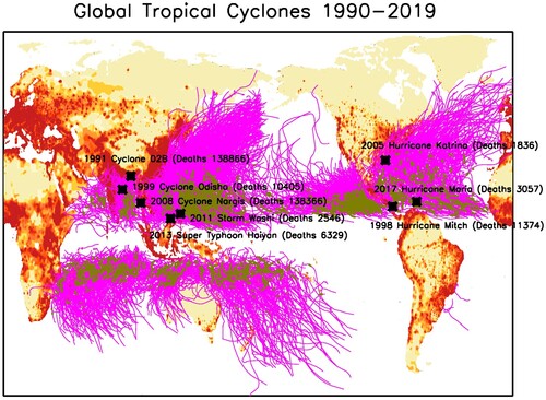
There have been a series of review papers discussing the history of tropical cyclone research (e.g. Bergeron, Citation1954; Emanuel, Citation2003; Emanuel, Citation2018; Gray, Citation1998; Montgomery & Smith, Citation2017; Ooyama, Citation1982; Riehl, Citation1950), most of which have emphasized theoretical and modelling studies. The purpose of this paper is to provide a brief review of observational and theoretical studies of tropical cyclones with an emphasis on observational work. Tropical cyclones are among the deadliest and costliest weather-related disasters. The 1970 Bhola cyclone is the deadliest tropical cyclone on record, with ∼500,000 fatalities in East Pakistan and India (Fritz et al., Citation2009). Despite improved technology and advancements in warning systems, tropical cyclones continue to cause large number of fatalities, and increasing amounts of property damage. Cyclone Nargis in 2008 killed 138,000 people in Bangladesh (Fritz et al., Citation2009), while Hurricane Katrina (2005), Tropical Storm Washi (2011), Super Typhoon Haiyan (2013) and Hurricane Maria (2017) had death tolls of 1836, 2546, 6329, 3057, respectively (). In 2017, three major hurricanes hitting the United States (U.S.) led to $268 billion in damage (NOAA NCEI, Citation2018), which cancelled 60% of the U.S. annual GDP growth in that year. The continued large death tolls and high financial losses from tropical cyclones reflect continued long-term challenges in tropical cyclone prediction as well as growing population exposure along the coastline (Klotzbach et al., Citation2018).
Fig. 1 Global map of population density in 2015 (red shading over land) and tracks of all tropical cyclones from 1990 to 2019 (magenta lines). Green dots on tracks are locations of rapid intensification events. Black boxes highlight some of the deadliest tropical cyclones in 1990–2019.
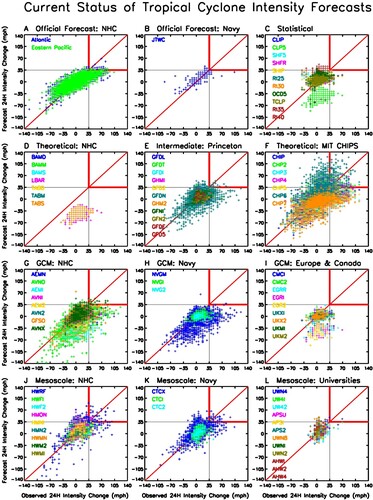
Forecasting tropical cyclone intensity, especially rapid intensification, remains one of the most vexing challenges in atmospheric science (Braun et al., Citation2018; Brown, Citation2017; Courtney et al., Citation2019a, Citation2019b; DeMaria et al., Citation2014; Hendricks et al., Citation2019; Rappaport et al., Citation2012). Tropical cyclone track forecasts have significantly improved over the past three decades (Cangialosi, Citation2018), but intensity improvements have occurred at a slower rate. More importantly, predicting rapid intensification remains extremely challenging (Brown, Citation2017), with state-of-the-art tropical cyclone forecast models often failing to predict rapid intensification ().
Fig. 2 Current status of tropical cyclone intensity forecasts (data from NCAR Tropical Cyclone Guidance Project, Citation2018).
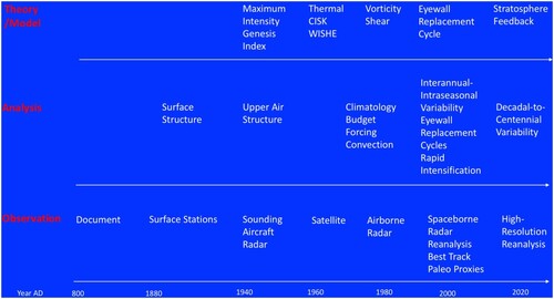
The history of tropical cyclone research is summarized in . The first tropical cyclone recorded in Chinese historical documents, and likely in historical documents around the world, is a Jufeng (typhoon) that struck the coastal city of Mizhou in northern China in 816 AD (Louie & Liu, Citation2003). Jufeng is the earliest terminology used in Chinese for tropical cyclone, and means convergence of winds. Historical documents provide valuable records of tropical cyclone events going back to the fifteenth century (Callaghan & Power, Citation2010; Chenoweth, Citation2006; Moreau de Jonnès, Citation1822; Poey, Citation1855), and are discussed in more detail later in this paper. On longer time-scales, paleoclimate proxies have been used to reconstruct tropical cyclone activity for the common era and for the entire Holocene Epoch (Donnelly, Bryant, et al., Citation2001; Donnelly, Roll, et al., Citation2001; Liu & Fearn, Citation1993, Citation2000; Mora et al., Citation2006; Scott et al., Citation2003).
Fig. 3 Timeline of tropical cyclone research.
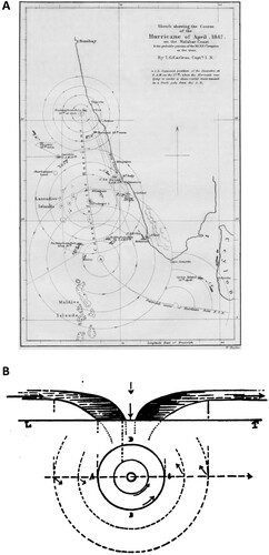
Basic modern meteorological instrumentation, such as rain gauges, anemometers, thermometers and barometers, were all invented by 1850. In the nineteenth century and the early twentieth century, there were numerous observational studies of tropical cyclone track, surface winds, central pressure and surface precipitation (e.g. Bowie, Citation1921; Carless, Citation1849; Chevalier, Citation1893; Cline, Citation1915; Fassig, Citation1928; Garriott, Citation1898; KimBall, Citation1915; Mitchell, Citation1926; Reid, Citation1846, Citation1849; Weightman, Citation1919). Carless (Citation1849) showed a track map of a hurricane occurring in April 1847, including a depiction of the surface wind structure ((a)). Chevalier (Citation1893) presented maybe the first schematic of tropical cyclone structure ((b)), which is quite similar to present-day schematics (e.g. Emanuel, Citation2018, see ).
Fig. 4 Tropical cyclone studies in the nineteenth century and early twentieth century. (a) Track of a hurricane in April 1847 (from Carless, Citation1849). (b) Schematic of tropical cyclone structure (from Chevalier, Citation1893).
Since then, observational tools for studying tropical cyclones have advanced to include upper air soundings, aircraft flight level instruments, satellite infrared and visible sensors, airborne radars, satellite microwave sensors and spaceborne radars, operational analysis, reanalysis, and paleoclimate proxies. Using these observational datasets, research has been conducted on tropical cyclone climatology, climate variability, surface structure, upper air structure, heat/moisture/angular momentum/vorticity budgets, and environmental forcing. Based on these observational studies, theories and models have been developed on tropical cyclone structure, maximum potential intensity, formation and intensification.
This paper will be organized as follows. Observational studies on tropical cyclone climatology and variability will be reviewed in Section 2. Studies on tropical cyclone structure will be reviewed in Section 3. Tropical cyclone theory will be reviewed in Section 4. A summary of current challenges and suggested future directions will be provided in Section 5.
2 Tropical cyclone climatology and variability
a Climatology and Empirical Genesis Indices
Before the satellite era, information on tropical cyclone track and intensity came from surface reports from land stations and ships. One of the earliest efforts to construct a global tropical cyclone climatology was Byers (Citation1944). Aircraft reconnaissance started after 1943, which was limited to the western Atlantic and parts of the Northwest Pacific. The launch of weather satellites in the 1960s and 1970s provided for the first time global coverage of tropical cyclone activity (e.g. Dvorak, Citation1975; Sadler, Citation1964). Regional best track datasets have been developed such as the National Hurricane Center (NHC) North Atlantic hurricane database (HURDAT/HURDAT2; Jarvinen et al., Citation1984; Landsea & Franklin, Citation2013), the Joint Typhoon Warning Center (JTWC) database (Chu et al., Citation2002), and the Southwest Pacific Enhanced Archive of Tropical Cyclones (SPEArTC) database (Diamond et al., Citation2012). The global IBTrACS database integrates data from all available sources (Knapp et al., Citation2010).
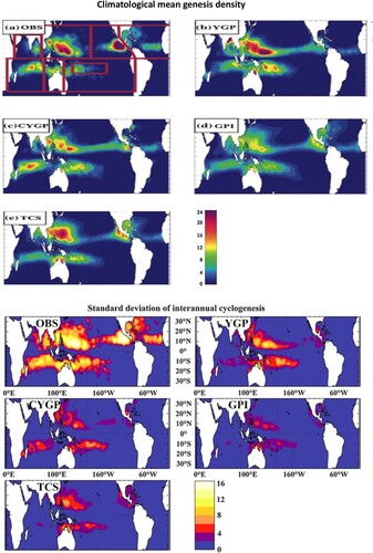
Tropical cyclones are convectively-coupled vortices generated inside a large-scale convective rotating environment. Tropical cyclones generally form and propagate within monsoon troughs and tropical/sub-tropical convergence zones. These regions are generally associated with convective disturbances, warm sea surface temperatures (SST), a moist lower troposphere, surface wind convergence, and large lower-tropospheric vorticity. Based on observations and theoretical considerations, empirical genesis indices have been developed such as the Yearly Genesis Parameter (YGP; Gray, Citation1968, 1975, Citation1979), the Modified Yearly Convective Genesis Potential Index (CYGP; Royer et al., Citation1998), the Genesis Potential Index (GPI; Emanuel & Nolan, Citation2004), and the Tippett et al. (Citation2011) index (TCS). Gray (Citation1968) constructed a comprehensive global climatology of tropical cyclone genesis and associated large-scale ocean-atmosphere environment using all datasets available at that time, and developed the YGP index (see also Gray, Citation1975, Citation1979, Citation1998). He showed that tropical cyclone genesis was closely related to six parameters: (1) the Coriolis parameter, (2) low-level relative vorticity, (3) tropospheric vertical wind shear, (4) ocean thermal energy, measured as ocean temperatures greater than 26°C to 60 m depth, (5) the difference in equivalent potential temperature between the surface and 500 mb, and (6) relative humidity in the mid-troposphere. The first three parameters specify a dynamic potential, while the last three parameters yield a thermal potential. The CYGP (Royer et al., Citation1998) is a variant of the YGP, and replaces the thermal potential of the YGP with a convective potential which is determined by convective precipitation from model output or reanalysis. The GPI (Emanuel & Nolan, Citation2004) also adopted low-level vorticity, vertical wind shear and mid-troposphere relative humidity as predictors, but also used maximum potential intensity (Bister & Emanuel, Citation1998) as a convective predictor. The TCS (Tippett et al., Citation2011) index is a variant of the GPI, and replaced maximum potential intensity with an SST index. Overall, the physical processes considered in the four indices are similar, but the mathematical formulations are different.
Menkes et al. (Citation2012) evaluated the performance of these four indices using reanalysis datasets and found that differences between indices are large and vary depending on the regions and on the timescales considered. Climatological mean genesis density for all indices exhibits large regional discrepancies, which can commonly reach up to ±50% ( upper panel). All indices except the TCS show an equatorward bias in climatological mean genesis, especially in the northern hemisphere where this bias can reach 5°. For seasonal timescales on which the indices are historically fitted, all indices reproduce the phase of the seasonal cycle adequately although with a bias in amplitude in some regions. The TCS is the best-fitted index overall. The most striking feature at interannual scales is the inability of all indices to reproduce the observed amplitude of interannual variability ( lower panel), although they can reproduce modulation linked to ENSO. In terms of genesis mechanisms inferred from the analysis of the contributing terms, the indices show a wide variation at seasonal timescales.
Fig. 5 (Upper) Climatological mean cyclogenesis numbers in (a) observations and predicted by genesis indices including the (b) YGP, (c) CYGP, (d) GPI and (e) TCS. (Lower) Standard deviation of interannual anomalies of cyclogenesis in observations and predicted by genesis indices (from Menkes et al., Citation2012).
Next, we review observational studies on the modulation of tropical cyclone activity by key global climate variability from intraseasonal time-scales to centennial time-scales. The dominant modes investigated herein are the Madden-Julian Oscillation (MJO), ENSO, the Atlantic Multi-decadal Oscillation (AMO), and global warming.
b MJO
The dominant tropical climate mode on intraseasonal time-scales is the MJO – the 30–90-day oscillation of tropical climate system (Lin et al., Citation2006; Madden & Julian, Citation1971). The MJO has been found to modulate tropical cyclone activity in different ocean basins including the western north Pacific (Kim et al., Citation2008; Li & Zhou, Citation2013; Liebmann et al., Citation1994), the northern Indian Ocean (Kikuchi & Wang, Citation2010; Krishnamohan et al., Citation2012; Liebmann et al., Citation1994), the northeast Pacific (Barrett & Leslie, Citation2009; Maloney & Hartmann, Citation2000a), north-central Pacific (Klotzbach & Blake, Citation2013), the North Atlantic (Aiyyer & Molinari, Citation2008; Barrett & Leslie, Citation2009; Klotzbach, Citation2010; Klotzbach, Citation2012; Klotzbach & Oliver, Citation2015; Maloney & Hartmann, Citation2000b; Ventrice et al., Citation2011), and the southern hemisphere (Bessafi & Wheeler, Citation2006; Chand & Walsh, Citation2010; Hall et al., Citation2001; Ho et al., Citation2006; Leroy & Wheeler, Citation2008; Ramsay et al., Citation2012). See Klotzbach (Citation2014) for an extensive review of the MJO-TC relationship. Liebmann et al. (Citation1994) first studied the relationship between tropical cyclones of the Indian and western Pacific oceans and the MJO. They found that tropical cyclones preferentially occur during the MJO’s convectively-enhanced phase and cluster around the MJO’s low-level cyclonic vorticity and convergence anomalies ((a)).
Fig. 6 Modulation of tropical cyclones by the MJO. (A) Composite positions of tropical cyclones (asterisks) relative to the MJO vorticity anomaly (from Liebmann et al., Citation1994). (B) (left) Statistically significant increases (green arrows) and statistically significant decreases (red arrows) in ACE from the phase 1–8 average by tropical cyclone basin. (right) Statistically significant differences in 200–850-mb vertical shear (westerly shear anomalies in red, easterly shear anomalies in blue) and 300-hPa omega (up arrows represent upward motion, down arrows represent downward motion) from the phase 1–8 average (from Klotzbach, Citation2014).
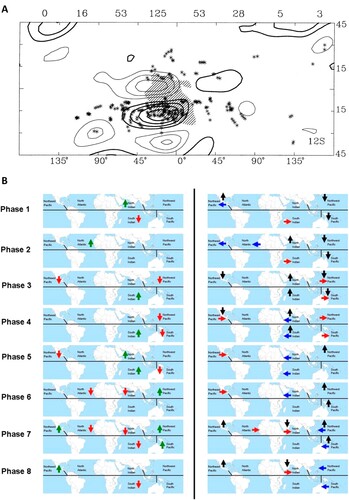
Camargo et al. (Citation2009) analysed global genesis density anomalies associated with different phases of MJO and found that they were consistent with an empirical genesis potential index. Of the four environmental variables comprising the index, mid-level relative humidity was the largest MJO-driven contributor, with low-level vorticity having the second largest contribution. Vertical wind shear and potential intensity only had minor contributions. Klotzbach (Citation2014) examined tropical cyclone genesis, rapid intensification, and basin-wide accumulated cyclone energy – an index accounting for frequency, intensity and duration of tropical cyclones – associated with the MJO lifecycle for all ocean basins, and found that the convectively-enhanced phases of the MJO and the phases immediately following them were typically associated with above-average tropical cyclone frequency for each of the global TC basins. The convectively suppressed phases of the MJO were typically associated with below-average tropical cyclone frequency ((b)). The number of rapid intensification periods was also shown to increase when the convectively-enhanced phase of the MJO was impacting a particular tropical cyclone basin.
c ENSO
The dominant global climate mode on interannual timescales is ENSO – the 3–7-year oscillation of tropical coupled ocean-atmosphere climate system (Bjerknes, Citation1969; Lin & Qian, Citation2019). In the Atlantic, in El Nino years, there is a tendency toward fewer tropical cyclones, while La Nina years increase Atlantic tropical cyclone activity (Gray, Citation1984; Gray et al., Citation1993; Gray & Sheaffer, Citation1991; Knaff, Citation1997; Patricola et al., Citation2015). ENSO also affects the number of landfalls in the United States, with fewer TCs experienced in El Niño years (Bove et al., Citation1998; Klotzbach et al., Citation2018; Pielke & Landsea, Citation1999). El Niño also tends to reduce Atlantic hurricane intensity (Landsea et al., Citation2004) and move tropical cyclone genesis locations outside of the tropics (Elsner & Kara, Citation1999). Factors that have been identified as responsible for these changes in tropical cyclone activity El Niño years are increases in vertical wind shear (Shapiro, Citation1987; Goldenberg & Shapiro, Citation1996; Patricola et al., Citation2015) and increases in upper-level temperatures, thereby stabilizing the atmosphere (Tang & Neelin, Citation2004).
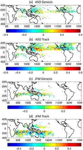
The modulation of tropical cyclones by ENSO can be summarized by (Camargo et al., Citation2007). In the western North Pacific, there is a southeastward (northwestward) shift of tropical cyclone activity in El Niño (La Niña) years (Chan, Citation1985; Chia & Ropelewski, Citation2002; Dong, Citation1988; Patricola et al., Citation2018; Wang & Chan, Citation2002). This southeastward shift in El Niño years has been attributed to the eastward extension of the monsoon trough and associated low-level westerlies in the western North Pacific (Lander, Citation1994, Citation1995) and reduction of vertical wind shear (Clark & Chu, Citation2002). In El Nino years typhoons also tend to last longer, become more intense, and have more recurving trajectories (Camargo et al., Citation2007; Camargo & Sobel, Citation2005; Wang & Chan, Citation2002), thereby also altering landfall probabilities for East Asian countries (Saunders et al., Citation2000; Elsner & Liu, Citation2003; Wu et al., Citation2004). Sobel and Camargo (Citation2005) hypothesized that anomalous typhoon-induced near-equatorial westerly winds generated in El Niño years might even act to strengthen the warm event, resulting in a positive feedback between El Niño and tropical cyclones.
Fig. 7 Modulation of tropical cyclones by ENSO. Difference of the anomalies in El Nino and La Nina years for (a) ASO genesis density, (b) ASO track density, (c) JFM genesis density and (d) JFM track density (from Camargo et al., Citation2007).
More hurricanes tend to form in the central Pacific during El Niño events (Clark & Chu, Citation2002). More tropical cyclones occur near Hawaii (Murakami et al., Citation2015). This has been attributed to smaller vertical wind shear and greater low-level relative vorticity in that region (Chu, Citation2004; Chu & Wang, Citation1997; Clark & Chu, Citation2002; Wu & Lau, Citation1992).
Eastern North Pacific tropical cyclone activity tends to be enhanced when Atlantic tropical cyclone activity is suppressed and vice versa (Elsner & Kara, Citation1999). Although no ENSO influence has been found in tropical cyclone frequency in the eastern North Pacific (Whitney & Hobgood, Citation1997), the number of intense hurricanes tends to increase in El Nino years (Gray & Sheaffer, Citation1991) and tropical cyclone activity shifts westward during El Nino events (Irwin & Davis, Citation1999), with an increased likelihood that some of these hurricanes will propagate into the central North Pacific (Chu, Citation2004). This shift has been attributed to environ- mental parameters having different characteristics east and west of 116°W (Collins & Mason, Citation2000) in ENSO years, with both dynamic and thermodynamic conditions becoming much more conducive in the western portion of the eastern North Pacific in El Niño years (Collins et al., Citation2016).
There is a strong association between the variability of sea surface temperatures in the Indian and Pacific Oceans (Pan & Oort, Citation1983). The association of north Indian Ocean tropical cyclone frequency and ENSO is apparent during the months of May and November, with fewer intense tropical cyclones occur during El Nino events (Singh et al., Citation2000). Girishkumar and Ravichandran (Citation2012) found that less accumulated cyclone energy was generated during October-December in the Bay of Bengal during El Niño years. They ascribed the decrease in El Niño years to anticyclonic vorticity anomalies, decreased convection and reduced upper ocean heat potential.
In El Nino years, an increase in the formation of tropical cyclones occurs in the South Pacific near the date line simultaneously with a decrease near Australia (Basher & Zeng, Citation1995; Evans & Allan, Citation1992; Hastings, Citation1990; Revell & Goulter, Citation1986). In La Nina years, an enhanced risk of landfall occurs in Australia with more tropical cyclones tracking close to the Queensland coast, while in El Nino years the tracks are more zonal west of the date line (Dong, Citation1988; Nicholls, Citation1979, Citation1985; Nicholls et al., Citation1998). This shift is related to the extension of the monsoon trough and equatorial westerlies in El Nino years in the South Pacific, favouring the formation of twin tropical cyclones (Ferreira et al., Citation1996), tropical cyclogenesis late in the season and east of 160°W in the South Pacific (Chu, Citation2004). Chand et al. (Citation2013) and Magee et al. (Citation2017) showed that tropical cyclone activity shifts northeastward during El Niño years in the South Pacific, leading to increased likelihood of impacts for French Polynesia, while TC activity is favoured in the Coral Sea region during La Niña events (Terry, Citation2007).
d Global Warming and AMO
There have been numerous observational studies on trends of tropical cyclone activity associated with global warming (e.g. Bhatia et al., Citation2019; Elsner et al., Citation2008; Emanuel, Citation2005; Klotzbach & Landsea, Citation2015; Knapp et al., Citation2007; Kossin, Citation2018; Kossin et al., Citation2013, Citation2014; Kossin & Vimont, Citation2007; Landsea, Citation2007; Landsea et al., Citation2006; Mei & Xie, Citation2016; Pielke et al., Citation2005; Schreck et al., Citation2014; Sobel et al., Citation2016; Studholme & Gulev, Citation2018; Webster et al., Citation2005; Weinkle et al., Citation2012). See Knutson et al. (Citation2010), Klotzbach and Landsea (Citation2015) and Walsh et al. (Citation2016) for reviews of related studies and Knutson et al. (Citation2019, Citation2020) for a detection and attribution assessment and a recent update on climate model response to anthropogenic warming, respectively. Webster et al. (Citation2005) documented a large and significant increase in both the number as well as the percentage of category 4 and 5 hurricanes for all global basins from 1970 to 2004, which was supported by Emanuel (Citation2005) with estimates of accumulated cyclone energy for the North Atlantic and western North Pacific basins. However, these results were questioned by several studies which pointed out the large uncertainty and short length of the datasets (e.g. Landsea et al., Citation2006; Pielke et al., Citation2005). Ten years later, with longer and better calibrated datasets, Klotzbach and Landsea (Citation2015) found that the global frequency of category 4 and 5 hurricanes has shown a small, insignificant downward trend while the percentage of category 4 and 5 hurricanes has shown a small, insignificant upward trend between 1990 and 2014. Accumulated cyclone energy globally had experienced a large and significant downward trend during the same period. The primary reason for the increase in category 4 and 5 hurricanes noted in observational datasets from 1970 to 2004 by Webster et al. (Citation2005) was concluded to be primarily due to observational improvements at the various global tropical cyclone warning centres, mostly in the period from 1970 to 1989. Bhatia et al. (Citation2019) used observations and a model experiment to study the intensification rates of tropical cyclones. Their results suggested a detectable increase of Atlantic intensification rates and reveal a need for more reliable data before detecting a robust trend at the global scale.
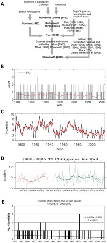
One limitation of modern tropical cyclone datasets is their short length. Historical documents provide important records of tropical cyclone occurrence and tracks for the time before modern observations began (Chenoweth, Citation2006; Garcia-Herrera et al., Citation2018; Scheitlin et al., Citation2010). The research on historical documents for the North Atlantic basin was started by Moreau de Jonnès (Citation1822) who used almanacs and written histories of the Caribbean colonies to document observed hurricanes in the West Indies back to the year 1495 ((a)). Meanwhile, Southey (Citation1827) created a chronology using information from British newspapers, and Reid (Citation1838, Citation1849), Redfield (Citation1831, Citation1854), and Piddington (Citation1848) uncovered additional cyclones using ship's log books, weather diaries, and other newspapers. Poey (Citation1855) summarized these studies together with his own research. Ludlum (Citation1963) and Millas (Citation1968) consulted the Poey list, and others built after that time and using it. More cyclones have been uncovered in subsequent studies (Fernandez-Partagas & Diaz, Citation1996; Mock, Citation2004). Chenoweth (Citation2006) conducted a reanalysis of the 1700–1855 portion of Poey's original published list using historical newspaper accounts, weather diaries, and ships’ logbooks. Of the 348 separate entries in Poey's original list, 149 were rejected and 198 were accepted. Due to errors in dating and location, and the linking of separate entries as parts of the same storm, only 170 of the 198 accepted entries were unique storms. Thirteen undated storms of the remaining 170 were dated. The authorities cited by Poey vary in their reliability. Of those cited 10 or more times, there was an average of one incorrect citation for every 3.1 correct citations. The most and least reliable authorities used by Poey were identified. An updated corrected chronology from all published sources was presented, which included 383 unique storms through 1855. The historical Atlantic basin chronology is still being updated (Chenoweth & Divine, Citation2008, Citation2012; Garcia-Herrera et al., Citation2005).
Fig. 8 (a) Major contributors leading to the Chenoweth archive (from Scheitlin et al., Citation2010). (b) The number of hurricanes passing through 10–20°N, 61.5°W from 1690 to 2007. The red line is the 21-year moving mean (from Chenoweth & Divine, Citation2008). (c) The number of cyclones in the Bay of Bengal. The red line is the 5-year running mean. (d) The number of landfalling tropical cyclones in the Philippines (from Kubota & Chan, Citation2009). (e) The number of landfalling tropical cyclones in eastern Australia. The linear trend of −0.0021 TCs year–1 is also shown (from Callaghan & Power, Citation2010).
In addition to the Atlantic, historical reconstructions of tropical cyclone activity have also occurred in other basins. Many tropical cyclone events were recorded in China’s official historical documents and have been compiled together by Zhang (Citation2013). Historical time series have also been reconstructed for the entire western North Pacific (Chan & Shi, Citation2000; Chen et al., Citation2019; Kubota & Chan, Citation2009; Liu et al., Citation2001; Zhang, Citation2013), the Northern Indian Ocean (Singh et al., Citation2000) and Australia (Callaghan & Power, Citation2010). On longer time-scales, tropical cyclone activity has been derived from paleoclimate proxies such as lake sediment cores, stalagmites, corals and marine sediment cores (Chen et al., Citation2012; Denommee et al., Citation2014; Donnelly, Bryant, et al., Citation2001; Donnelly, Roll, et al., Citation2001, Citation2015; Donnelly & Woodruff, Citation2007; Haig et al., Citation2014; Liu & Fearn, Citation1993, Citation2000; Mora et al., Citation2006; Nyberg et al., Citation2007; Scott et al., Citation2003; Toomey et al., Citation2013, Citation2016; van Hengstum et al., Citation2013; Zhou et al., Citation2019).
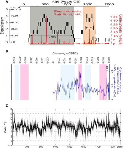
shows the historical records of tropical cyclones in (b) the North Atlantic (Chenoweth, Citation2006), (c) the Indian Ocean, (d) the northwestern Pacific (Kubota & Chan, Citation2009), and (e) Australia (Callaghan & Power, Citation2010). None of the records show an increasing trend of tropical cyclone activity. In fact, both the Indian Ocean record and the Australian record show a decreasing trend. Since it is more difficult to uncover tropical cyclones occurring earlier in the record, these historical records generally tend to underestimate the tropical cyclone numbers in the early parts of the records. These basins require additional research and study before any definitive conclusion on trends can be made.
shows tropical cyclone activity in the Common Era reconstructed from paleoclimate records in the (a) North Atlantic (Donnelly et al., Citation2015), (b) the northwestern Pacific (Zhou et al., Citation2019), and (c) Australia (Haig et al., Citation2014). Similar to the historical records, the paleoclimate records do not show increasing trends in tropical cyclone activity. Therefore, modern instrument records, historical records and paleoclimate records consistently suggest that overall tropical cyclone activity does not increase (and may actually decrease) with ongoing global warming, similar to what has been found in recent climate model analysis with anthropogenic warming forcing by Knutson et al. (Citation2020).
Fig. 9 (a) Hurricane activity index (red) and number of hurricane events per century (black) for Salt Pond, MA (from Donnelly et al., Citation2015). (b) Tropical cyclone activity index for the northwestern Pacific (from Zhou et al., Citation2019). (c) Tropical cyclone activity index for Western Australia (from Haig et al., Citation2014).
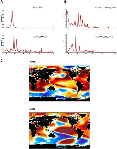
One of the primary drivers of the global climate on multi-decadal timescales is the AMO. Many studies have analysed the modern instrumental record and found that the AMO strongly modulates tropical cyclone activity in the Atlantic basin (Bell & Chelliah, Citation2006; Caron et al., Citation2015; Goldenberg et al., Citation2001; Klotzbach, Citation2011; Klotzbach & Gray, Citation2008; Knight et al., Citation2006; Zhang et al., Citation2018; Zhang & Delworth, Citation2006), with more Atlantic hurricane activity occurring when the AMO is positive. Positive phases of the AMO are associated with a warmer tropical North Atlantic, reduced vertical wind shear and increased instability, favouring increases in Atlantic hurricane activity and US landfalling hurricane activity (Klotzbach et al., Citation2018). There are many proposed mechanisms of AMO, such as the North Atlantic Oscillation (NAO) coupled oscillator (Delworth et al., Citation2017; Sutton et al., Citation2018; Timmermann et al., Citation1998), cloud-radiation feedback (e.g. Clement et al., Citation2015), and external volcano forcing (e.g. Birkel et al., Citation2018; Knudsen et al., Citation2014; Mann et al., Citation2020, Citation2021).
(a) illustrates the maximum entropy spectrum of the AMO index from ERSST for 147 years (1880–2016) and LMR2.0 reanalysis for the past 2000 years. They both show strong spectral peaks at the multi-decadal timescale between 40–90 years. (b) demonstrates the maximum entropy spectrum of tropical cyclone activity index for North Atlantic and Northwestern Pacific. They also show strong peaks at the multi-decadal timescale between 40 and 90 years. Spectral peaks in the same frequency band are not necessarily correlated with each other. To test the correlation, (c) illustrates the lag-correlation of global LMR SST anomalies with tropical cyclone activity index for the two ocean basins. Black stars denote the grids with correlation coefficient above the 95% confidence level. For North Atlantic, tropical cyclone activity is significantly correlated with global SST anomalies and the pattern is similar to the AMO SST pattern. For Northwestern Pacific, tropical cyclone activity is also significantly correlated with global SST anomalies and the pattern is similar to the ENSO SST pattern. Therefore, paleoclimate datasets confirm that the AMO significantly modulates tropical cyclone activity in North Atlantic for the past 2000 years.
Fig. 10 (a) Maximum entropy spectrum of the AMO index from ERSST and LMR2.0 reanalysis. (b) Maximum entropy spectrum of tropical cyclone activity index for North Atlantic (NATL; Donnelly et al., Citation2015) and Northwestern Pacific (NWP; Zhou et al., Citation2019). (c) Lag-correlation of LMR SST anomalies with tropical cyclone activity index for the NATL and NWP. Black stars denote the grids with correlation coefficient above the 95% confidence level.
3 Tropical cyclone structure
In this section, we review the observational studies on tropical structure following approximately the timeline in history and from lager spatial scales to smaller spatial scales. The observations of tropical structure began at the surface, and then advanced to the upper levels. Since the spatial resolution of tropical cyclone observational datasets has been increasing with time, observational studies advanced from lager spatial scales to smaller spatial scales, i.e, from the external large-scale environment to the internal cyclone-scale structure, and then to the inner core, the eyewall and the central eye. Therefore, we will review first the observational studies of the surface and boundary layer structure of tropical cyclones, and then the horizontal structure from the large-scale environment into the central eye, followed by the vertical structure from the large-scale environment into the central eye.
a Surface and Boundary Layer Structure
The surface boundary layer structure of tropical cyclones and associated physical processes have been studied using radar, aircraft flight-level and dropwindsonde data (Barnes & Powell, Citation1995; Black et al., Citation2007; Black & Holland, Citation1995; Blackwell, Citation2000; Cione et al., Citation2020; Drennan et al., Citation2007; Franklin et al., Citation2003; French et al., Citation2007; Giammanco et al., Citation2012; Hock & Franklin, Citation1999; Huang, Wu, et al., Citation2018; Kepert, Citation2006a, Citation2006b; Knupp et al., Citation2006; Lee & Chen, Citation2012; Molinari et al., Citation2013; Moss, Citation1978; Moss & Merceret, Citation1976, Citation1977; Powell, Citation1982, Citation1990a, Citation1990b; Powell et al., Citation2003; Schneider & Barnes, Citation2005; Schwendike & Kepert, Citation2008; Sparks et al., Citation2019; Tang et al., Citation2018; Vickery et al., Citation2009; Wroe & Barnes, Citation2003; Zhang, Black, et al., Citation2008; Zhang et al., Citation2009; Zhang, Marks, et al., Citation2011; Zhang, Rogers, et al., Citation2011, Citation2013; Zhang & Drennan, Citation2012; Zhang & Uhlhorn, Citation2012). The implementation of the Global Positioning System dropwindsonde (GPS sonde) provided a wealth of high resolution wind profiles within tropical cyclones (Hock & Franklin, Citation1999). GPS sonde composite wind profiles contained a jet-like structure with a logarithmic increase in wind speed from the surface often to the height of the maximum wind speed, followed by a gradual decrease in wind speed above the height of the maximum wind speed (e.g. Franklin et al., Citation2003; Powell et al., Citation2003; Vickery et al., Citation2009).
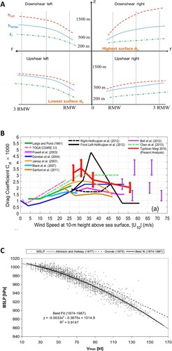
Zhang et al. (Citation2013) constructed a composite boundary layer structure using 1878 GPS dropsondes in 19 hurricanes ((a)). The kinematic boundary layer height (the frictional inflow layer height) is almost double the thermodynamic boundary layer height (the well-mixed layer height). The height of the maximum tangential wind was located between the kinematic and thermodynamic boundary layer heights. All three boundary layer heights decrease inward towards the centre of the tropical cyclone. The frictional inflow layer height is higher in the downshear quadrants, with the downshear-right quadrant being the highest. The well-mixed layer height and the height of maximum tangential wind speed are very similar at the eyewall, but are higher outside in the left quadrants. Estimates of vertical eddy diffusivity (Km) from observations in the eyewall boundary layer are difficult to obtain. There are only a few observations in the North Atlantic (Zhang, Marks, et al., Citation2011), the western North Pacific (Sparks et al., Citation2019), and over land (Tang et al., Citation2018). Zhang, Marks, et al. (Citation2011) found that the turbulence parameters estimated underneath the eyewall are nearly an order of magnitude larger than those outside of the eyewall. In the intense eyewall region, the horizontal length scale of the dominant turbulent eddies is between 500 and 3000 m, and the corresponding vertical length scale is approximately 100 m. Sparks et al. (Citation2019) found a superlinear relationship between diffusivity and wind speed in the eyewall region in western North Pacific typhoons, which is different from the more linear relationship in Atlantic hurricanes. Tang et al. (Citation2018) studied three landfalling tropical cyclones and found that the estimated Km was significantly larger than the oceanic values, suggesting that models should use different parameterizations of Km over land versus over ocean.
Fig. 11 Boundary layer processes. (a) Schematic diagram of the characteristic height scales in the tropical cyclone boundary layer for the four quadrants relative to the shear direction (from Zhang et al., Citation2013). (b) The drag coefficient Cd as a function of 10 m wind speed from various studies (from Hsu et al., Citation2017). (c) MSLP vs best-track maximum surface winds (Vmax) interpolated to the time of the observations and the associated best-fit relationships to these data for 1974–87 (from Knaff & Zehr, Citation2007).
Boundary layer rolls have been observed in tropical cyclones, and their impacts on eddy flux transport are still under investigation (Lorsolo et al., Citation2008; Morrison et al., Citation2005; Wurman & Winslow, Citation1998; Zhang, Katsaros, et al., Citation2008; Huang, Li, et al., Citation2018). Boundary layer rolls generally have a wavelength of 200–1600 m. Using National Weather Service WSR-88D Doppler radars, Morrison et al. (Citation2005) found that rolls occurred in 35–69% of radar volumes of tropical cyclones. Zhang, Katsaros et al. (Citation2008) analysed aircraft data and suggested that roll vortices may be a significant factor modulating air–sea momentum exchange. Spaceborne synthetic aperture radar provides a unique capability to image the sea surface imprints of quasi-linear streaks induced by these rolls. Huang, Li et al. (Citation2018) analysed synthetic aperture radar images and found rolls underneath the eye, eyewall and rainbands. The roll wavelengths were longest just outside of the RMW, and decrease both inward and outward. The spatial distribution of these roll wavelengths was asymmetrical.
An important boundary layer process related to tropical cyclone intensity change is the levelling off, or limiting value, of the marine drag coefficient in high winds (Bell et al., Citation2012; Black et al., Citation2007; Chen et al., Citation2013; Donelan et al., Citation2004; Holthuijsen et al., Citation2012; Hsu et al., Citation2017; Jarosz et al., Citation2007; Powell et al., Citation2003; Sanford et al., Citation2011; Vickery et al., Citation2009; (b)). Moreover, the drag coefficient, given similar wind speeds, is smaller for smaller-radii storms (Vickery et al., Citation2009). Enhanced sea spray by short or breaking waves is speculated as a cause for this observed relationship.
The relationship between maximum surface wind speed and minimum sea level pressure is important for tropical cyclone monitoring and forecasting. Tropical cyclones are well approximated by gradient wind balance, which determines the wind-pressure relationship (Chavas et al., Citation2017; Willoughby, Citation1990; Willoughby & Rahn, Citation2004). Because the actual relationship is a function of several factors related to the tropical cyclone environment and structure which vary from case to case, there is considerable scatter about any given wind-pressure relationship (Atkinson & Holliday, Citation1977; Courtney & Knaff, Citation2009; Dvorak, Citation1975; Harper, Citation2002; Koba et al., Citation1990; Knaff & Zehr, Citation2007; Kossin, Citation2015; Love & Murphy, Citation1985). Knaff and Zehr (Citation2007) compared the various wind-pressure relationships used in different basins ((c)). They found that latitude, size, and environmental pressure, which all can be quantified in an operational and post-analysis setting, are related to predictable changes in the wind-pressure relationships. These factors can be combined into equations that estimate winds given pressure and estimate pressure given winds with greater accuracy. Kossin (Citation2015) studied the changes of wind-pressure relationships in eyewall replacement cycles that have been observed in North Atlantic hurricanes. He found that the wind-pressure relationship can vary substantially during an eyewall replacement cycle depending on the intensity at the start of the cycle, and these relationships may be considerably different than the typical Dvorak wind-pressure relationship used in that basin.
b Horizontal Structure from the Large-Scale Environment to the Central Eye
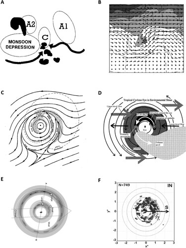
Observational studies have found many large-scale environmental conditions favouring tropical cyclone formation, such as monsoon shearlines, low-level wind surges, nearby previously developed tropical cyclone, interaction of binary vortices, and upper-troposphere synoptic-scale environment. Tropical cyclones tend to form on monsoon shearlines in the western North Pacific and Australian region (Chen et al., Citation2004; Harr et al., Citation1996; Holland, Citation1995; Lander, Citation1994; McBride & Keenan, Citation1982; Ramage, Citation1974b; Ritchie & Holland, Citation1999; Wu et al., Citation2013; Zong & Wu, Citation2015a, Citation2015b), and inside the troughs of easterly waves in the North Atlantic and Eastern North Pacific basins (Avila, Citation1991; Avila & Pasch, Citation1992; Dunkerton et al., Citation2009; Dunn, Citation1940; Hankes et al., Citation2015; Hopsch et al., Citation2010; Landsea, Citation1993; Leppert et al., Citation2013a, Citation2013b; Molinari et al., Citation1997; Palmer, Citation1952; Thorncroft & Hodges, Citation2001; Wang, Citation2018; Wang & Hankes, Citation2014; Zawislak & Zipser, Citation2014). In the western North Pacific and Australian region, the monsoon shearlines are associated with strong low-level vorticity, convergence and convection, all favouring development of tropical cyclones ((a); Holland, Citation1995). McBride and Keenan (Citation1982) studied 20 years of tropical cyclone genesis in the Australian region, and found that 97% of pre-cyclone cloud clusters are on the monsoon shearline at the point of development. Zong and Wu (Citation2015b) analysed 11 years of tropical cyclone genesis in the western North Pacific, and found that nearly all of the genesis events occurred on the monsoon shearline. For the North Atlantic and the eastern North Pacific, tropical cyclone genesis is often associated with easterly waves. Theoretically, when waves propagate in shear flow and arrive at the critical layer where mean flow and wave speed are equal, parcels experience irreversible displacements and trapping in the location of “cat’s eye”, which was named after the shape of the flow pattern (Andrews & McIntyre, Citation1978). Dunkerton et al. (Citation2009) studied 61 named storms from 1998 to 2001, and found that 88% of them were clearly generated by easterly waves. In the remaining seven cases, either a multiple-wave interaction was involved, or easterly waves were not well-defined. They suggested that the cat's eye in the critical layer provided anomalous cyclonic low-level vorticity, enhanced moisture, increased convection, and mesoscale vortex aggregation, that all feedback on the parent wave, favouring tropical cyclone formation. Wang (Citation2018) analysed 150 Atlantic named storms and found that they generally formed near the centre of the cat’s eye in easterly waves. Leppert et al. (Citation2013a) examined 10 years of easterly waves in the Atlantic and eastern North Pacific, and found that waves that developed into tropical cyclones have larger fractional coverage of deep convection than non-developing cases.
Fig. 12 Horizontal structure. (a) Schematic of the interacting mechanisms leading to enhanced potential for tropical cyclone formation in the monsoon confluence zone (from Holland, Citation1995). (b) Horizontal plot on the 200 mb surface for the favourable superposition of an upper-level trough composite with wind vectors and Ertel PV (shaded). The increment in longitude and latitude is 10 degrees (from Hanley et al., Citation2001). (c) Schematic representation of the horizontal structure of radar reflectivity and the atmospheric flow in which it is imbedded (from Willoughby et al., Citation1984). (d) Schematic illustration of shear-induced convective asymmetry based upon observations of Jimena and Olivia (from Black et al., Citation2002). (e) Horizontal structure of a tropical cyclone with concentric eyewalls. The dashed arrow represents environmental shear (from Hence & Houze, Citation2012). (f) Location of convective bursts in intensifying tropical cyclones. Radial coordinates are normalized by RMW. Black arrow represents environmental shear (from Rogers et al., Citation2013).
Low-level wind surges sometimes serve as triggers for tropical cyclogenesis (Briegel & Frank, Citation1997; Fujita et al., Citation1969; Gray, Citation1998; Lee et al., Citation1989; Li, Citation1936; Love, Citation1985a, Citation1985b; Yokoi & Takayabu, Citation2010; Zehr, Citation1992). Fujita et al. (Citation1969) presented a case study showing that large-scale cross-equatorial wind surges from the winter hemisphere to the summer hemisphere can generate anticyclones in the summer hemisphere, which interact with the subtropical high and aid in tropical cyclone formation. This was confirmed to be a fairly common scenario by the composite study of Love (Citation1985b). In other cases, low-level wind surges may come from the subtropics. Yokoi and Takayabu (Citation2010) found that the formation of cyclone Nargis was triggered by a low-level easterly surge blowing towards the genesis point from the subtropics. Horizontal convergence at the head of the surge associated with active convection induced externally forced convergence that triggered cyclogenesis. In addition, the active convection seemed to contribute to the preconditioning of mid-tropospheric humidity. The easterly surge was associated with a cold surge in the eastern coastal portion of the Eurasian continent, which is a typical feature of cold surges in April.
Tropical cyclone formation and track can be strongly affected by the presence of a nearby previously developed tropical cyclone, and the interaction of these binary vortices has been a frequent topic of study (Brand, Citation1970; Carr et al., Citation1997; Carr & Elsberry, Citation1998; Dong & Neuman, Citation1983; Haurwitz, Citation1951; Hoover, Citation1961; Jang & Chun, Citation2015; Lander, Citation1995; Lander & Holland, Citation1993; Qian et al., Citation2016; Wu et al., Citation2003; Yang et al., Citation2008). Dong and Neuman (Citation1983) studied 36 years of data and found that the annual average number of binary cyclone events is 1.5 in the western North Pacific and 0.33 in the North Atlantic. Lander and Holland (Citation1993) analysed 43 years of binary cyclone events and found a variety of interactions including capturing, stable cyclonic orbiting, cyclone merging, and cyclone escaping. Jang and Chun (Citation2015) studied binary cyclone events in western north Pacific for 62 years (1951–2012). A total of 98 binary TCs occurred with an annual average of 1.58. The occurrence frequency of binary TCs shows significant year-to-year variations and there are two peaks in the mid-1960s and early 1990s. Three-fourths (76.3%) of the binary TCs occurred between July and September, which is consistent with the high activity season of TCs in general. They identified six representative trajectories strongly related to the environmental flow and the location of the subtropical high.
The upper-troposphere synoptic-scale environment associated with tropical cyclones is often characterized by anticyclonically curved flow as part of a large-scale ridge, and a poleward/eastward outflow jet linking the tropical cyclone with midlatitude westerlies (e.g. Black & Anthes, Citation1971; Chen et al., Citation2015; Colon & Nightingale, Citation1963; Fett, Citation1966; Fischer et al., Citation2019; Hanley et al., Citation2001; Merrill, Citation1988a, Citation1988b; Molinari et al., Citation1995, Citation1998; Ramage, Citation1974a; Riehl, Citation1948; Sadler, Citation1976, Citation1978; Shieh et al., Citation2013). Hanley et al. (Citation2001) constructed composites for six types of upper-tropospheric flow associated with tropical cyclones, all of which contained a large-scale ridge with four possessing an outflow jet. An example is shown in (b). The poleward/eastward outflow jet tends to generate an eddy flux convergence of angular momentum (DeMaria et al., Citation1993; Fischer et al., Citation2019; Molinari & Vollaro, Citation1989; Peirano et al., Citation2016; Wu & Cheng, Citation1999), but there is debate on whether the eddy flux convergence of angular momentum is connected to rapid intensification. Potential vorticity associated with the trough can advect inward and may enhance inner-core potential vorticity and thereby strengthen the tropical cyclone (Leroux et al., Citation2013). Vorticity advection generates a quasi-geostrophic forcing of upward motion and enhances genesis (Bracken & Bosart, Citation2000; Fischer et al., Citation2017). Equatorward intrusion of an upper-tropospheric trough may also enhance the outflow jet and favour intensification, as long as it does not generate overly strong shear (Hanley et al., Citation2001). These interactions are also sensitive to the details of the ridge-trough configuration (Chen et al., Citation2015; Fischer et al., Citation2019; Hanley et al., Citation2001; Peirano et al., Citation2016).
The internal structure of tropical cyclones has been studied using weather radar, especially Doppler radar, aided by aircraft flight-level data and dropsondes (e.g. Black & Hallett, Citation1999; Black et al., Citation2002; Bluestein & Marks, Citation1987; Bundgaard, Citation1958; Dodge et al., Citation1999; Fletcher et al., Citation1961; Gamache et al., Citation1993; Guimond et al., Citation2010, Citation2016; Halverson et al., Citation2006; Heymsfield et al., Citation2010; Houze et al., Citation1992; Citation2007, Citation2009; Jordan, Citation1959; Jorgensen, Citation1984a, Citation1984b; Lussier et al., Citation2014; Marks, Citation1985; Marks & Houze, Citation1984, Citation1987; Marks et al., Citation1992; Montgomery et al., Citation2014; Nguyen et al., Citation2017; Raymond & Lopez Carillo, Citation2011; Rogers et al., Citation2012, Citation2013, Citation2015, Citation2016; Sanger et al., Citation2014; Simpson & Starrett, Citation1955; Wadler, Rogers, et al., Citation2018; Wadler, Zhang, et al., Citation2018; Wexler, Citation1947; Willoughby et al., Citation1982, Citation1984; Zawislak et al., Citation2016). Willoughby et al. (Citation1984) constructed a composite horizontal structure of the full tropical cyclone using airborne radar reflectivity and in situ dynamic and thermodynamic data ((c)). They found that the hurricane vortex may be divided into an inner gyre with closed air trajectories moving with the vortex, and an outer envelope with open environmental air trajectories passing through the vortex and around the core. Spiral rainbands form near the boundary between the core and the envelope where the Rossby number is of order unity. Spiral rainbands differ dynamically both from convective rings due to its asymmetric nature and from propagating gravity-wave bands because its Doppler-shifted frequency is below the local inertia frequency. In more intense systems with stronger convective instability, spiral rainbands may evolve into a convective ring and move into the vortex core. Outward propagating gravity-wave bands have also been observed, which are often associated with track oscillations as the storm makes landfall or recurves. The eyewall and spiral rainbands are generated along the cyclonic uplifting atmospheric inflow into the centre of tropical cyclone.
The internal structure of a tropical cyclone, especially its asymmetric structure, is significantly affected by environmental wind shear, as revealed by both aircraft reconnaissance data (e.g. Black et al., Citation2002; DeHart et al., Citation2014; Miller, Citation1964; Simpson & Riehl, Citation1958; Wadler, Rogers, et al., Citation2018) and satellite measurements (Alvey et al., Citation2015; Chen et al., Citation2006; Tao & Jiang, Citation2015; Tao et al., Citation2017; Zagrodnik & Jiang, Citation2014). Black et al. (Citation2002) analysed the effects of shear on the horizontal structure of two hurricanes ((d)). Convective updrafts formed in the downshear side of the eyewall and advected around the eye and ascended to the tropopause when reaching the upshear side of the eyewall, while precipitation-driven downdrafts started at the upshear side and predominated below 6 km. Wadler, Rogers, et al. (Citation2018) constructed composites using aircraft passes over a 13-year period. They found that the downshear-right region had the lowest and weakest updrafts, while the upshear-left region had the highest and strongest updrafts, which confirmed the results from the case study of Black et al. (Citation2002). They further discovered that, comparing with steady-state storms, intensifying storms have higher and stronger updrafts advected into the upshear-left region, as well as stronger and deeper updrafts inside the RMW. Chen et al. (Citation2006) examined TRMM satellite-measured surface rainfall in both the northern hemisphere (NH) and southern hemisphere (SH). They discovered that shear enhanced the rainfall asymmetry, and the maximum rainfall is located in the downshear-left quadrant in the NH, which rotates more to the upshear-left quadrant when intensity increases. The surface rainfall maximum is consistent with the highest and strongest updrafts observed by aircraft reconnaissance. For the SH, the maximum rainfall is in the downshear-right quadrant, suggesting that, similar to the NH, convective updrafts gradually grow higher and stronger following the rotating wind around the eyewall. A stronger eyewall vortex advects the convective updrafts further downstream.
Regarding the eyewall, tropical cyclones occasionally have concentric eyewalls and go through eyewall replacement cycles (ERCs) with the old eyewall contracting and gradually being replaced by a growing outer new eyewall (e.g. Bell et al., Citation2012; Black & Willoughby, Citation1992; Blackwell, Citation2000; Didlake et al., Citation2017, Citation2018; Didlake & Houze, Citation2011, Citation2013a, Citation2013b; Dodge et al., Citation1999; Dougherty et al., Citation2018; Fischer et al., Citation2020; Fortner, Citation1958; Hence & Houze, Citation2012; Holliday, Citation1977; Hoose & Colon, Citation1970; Houze et al., Citation2007; Jordan, Citation1966; Jordan & Schatzle, Citation1961; Kossin & Sitkowski, Citation2009; Kuo et al., Citation2009; Molinari et al., Citation2019; Samsury & Zipser, Citation1995; Sitkowski et al., Citation2011, Citation2012; Willoughby et al., Citation1982; Wu et al., Citation2012; Yang et al., Citation2013, Citation2014; Zhu & Yu, Citation2020). Occasionally triple eyewalls are also observed (McNoldy, Citation2004; Zhao et al., Citation2016). Concentric eyewalls occur primarily in major hurricanes (Hawkins et al., Citation2006; Kossin & Sitkowski, Citation2009; Kuo et al., Citation2009). 55% of major hurricanes in the western North Pacific, 70% in the Atlantic, and 35% in the eastern North Pacific have concentric eyewalls at least once in their lifetime. For major hurricanes reaching an intensity of 138 mph (above category 4), the percentages are 80% for the western North Pacific, 70% for the Atlantic, 50% for the eastern North Pacific, and 40% for the SH. Over the western North Pacific, 27% of all tropical storms and 40% of hurricanes have concentric eyewalls at some point during their lifetime.
Sitkowski et al. (Citation2011) studied the lifecycle of ERC using 31 years of flight level data from 79 Atlantic hurricanes. They identified three phases of ERCs: intensification, weakening, and reintensification. The entire ERC lasts 36 h on average. All times and intensities listed in the discussion that follows are composite averages. The first phase lasts for ∼9 h and often exhibits rapid intensification with the inner wind maximum intensifying by 7 m s–1 (41 mph day–1), while the outer wind maximum intensifies by 5 m s–1 (29 mph day–1). The second phase lasts for ∼16 h with the inner wind maximum weakening by −10 m s–1 (−33 mph day–1), while the outer wind maximum intensifies by 9 m s (30 mph day–1). The third phase lasts for ∼11 h with the inner wind maximum weakening by −7 m s–1 (−34 mph day–1), while the outer wind maximum intensifies by 4 m s–1 (19 mph day–1).
Hence and Houze (Citation2012) analysed the horizontal structure of concentric eyewalls using 10 years of TRMM satellite radar data ((e)). They found that, similar to the single eyewall, the convective cells begin their development in the downshear-right quadrant, grow and intensify in the downshear-left quadrant, and become weaker in the upshear-left quadrant, before dissipating entirely in the upshear-right quadrant. The bulking of the precipitation in the downshear-left quadrant of the primary eyewall results in a narrowing of the moat in that quadrant, whereas the moat in the upshear-right quadrant is wider and clearer. Recently, Zhu and Yu (Citation2020) analysed environmental influences on tropical cyclone concentric eyewalls, and found that concentric eyewalls occurred in a relatively quiescent environment with weaker inflows, weaker low-level troughs, and weaker sub-tropical highs.
Regarding the central eye, a long-term misconception is that the tropical cyclone eye is a region free of deep convection. Rogers et al. (Citation2013) analysed airborne Doppler radar observations from 93 eyewall passes, and found cases with a large number of convective bursts inside the eye, especially during rapid intensification events ((f)). Wadler, Rogers, et al. (Citation2018) compared the hot towers between rapid intensification events and steady-state events and found that the intensifying events have stronger and deeper updrafts inside the RMW. Zagrodnik and Jiang (Citation2014) constructed composite convection and latent heating structure using 14 years of TRMM precipitation radar data, and found that strong convection and latent heating occurred in the innermost 50 km region, especially for altitudes above 10 km. They also found that rapid intensification was associated with enhancement of moderate-to-deep convection in the innermost 50 km region. Alvey et al. (Citation2015) constructed composites using 15 years of satellite passive microwave measurements and obtained similar results. Ground and satellite observations of lightning distribution in tropical cyclones also show strong convection inside the eye (Cecil & Zipser, Citation1999; DeMaria et al., Citation2012; Jiang & Ramirez, Citation2013; Molinari et al., Citation1994, Citation1999; Stevenson et al., Citation2014, Citation2016, Citation2018; Xu et al., Citation2017).
c Vertical Structure from the Large-Scale Environment to the Central Eye
Our knowledge of a tropical cyclone’s vertical structure has advanced significantly from the large-scale environment to the central eye through analysis of upper air soundings, airborne Doppler radar and flight level data. The evolution of summary schematics clearly shows the progress of our knowledge of a tropical cyclone’s vertical structure ().
Fig. 13 Vertical structure. (a) Vertical cross-section of potential temperature (solid) and temperature (dashed) of a hurricane (from Palmen, Citation1948). (b) Schematic view of convection and the secondary circulation a typical tropical cyclone (from Frank, Citation1977a). (c) Convective and mesoscale updrafts and downdrafts in the inner core (from Marks & Houze, Citation1987). (d) Precipitation processes, cloud distribution and charge separation in tropical cyclones (from Black & Hallett, Citation1999). (e) Vertical structure of a sheared tropical cyclone (Cristobal 2014) (from Nguyen et al., Citation2017). (f) Vertical structure of a hurricane undergoing eyewall replacement (from Houze et al., Citation2007). (g) Composite vertical cross-section of latent heating (from Zagrodnik & Jiang, Citation2014). (h) Composite vertical cross-section of convective bursts in the eyewall (from Wadler, Rogers, et al., Citation2018).
The earliest upper air observations in the 1930s and 1940s provided the first view of the vertical structure of tropical cyclones and associated large-scale environment (Haurwitz, Citation1935; Palmen, Citation1948; Simpson, Citation1947; Wexler, Citation1945). It has long been speculated that the low central pressure of a tropical cyclone is associated with high temperatures in the eye. Based on the application of the hydrostatic equation to temperature measurements in typhoon eyes as they passed over high mountains, Haurwitz (Citation1935) correctly inferred the tropospheric warm core in tropical cyclones and the vertical tilt of eyewall. By piecing together the earliest aircraft flights into hurricanes, Wexler (Citation1945) presented a schematic of the vertical structure of a tropical cyclone showing tilted deep eyewall convection and a secondary circulation. Simpson (Citation1947) constructed vertical cross-sections of temperature and relative humidity. Using upper-air radiosonde data, Palmen (Citation1948) presented a vertical cross-section of temperature and potential temperature for the whole tropical cyclone ((a)). He stated: “This picture of the hurricane shows us a vortex of a warm core consisting of ascending moist air and inside it another still warmer, but much drier air originally produced by strong subsidence”. The tropospheric warm core has since been confirmed by many studies (Hawkins & Imbembo, Citation1976; Hawkins & Rubsam, Citation1968; Jordan, Citation1961; LaSeur & Hawkins, Citation1963).
After accumulation of sounding data for several decades, it was possible to construct composites of tropical cyclone’s internal structure, especially the wind flow as well as heat, moisture, angular momentum and vorticity budgets (Frank, Citation1977a, Citation1977b; Holland & Merrill, Citation1984; Lee, Citation1989a, Citation1989b; McBride, Citation1981; McBride & Zehr, Citation1981; Merrill, Citation1984, Citation1988a, Citation1988b). The schematic by Frank (Citation1977a) added convective heating associated with the eyewall and spiral rainbands, as well as the secondary circulation ((b)). There is an inflow convergence layer from the surface to 800 mb, and an outflow divergence layer at 400 mb and above with a peak around 150 mb. There is strong large-scale ascent in the inner-core region and much weaker descent in the outer region. The vertical profile of tangential wind is bottom-heavy and peaks around 850 mb. Relative humidity increases inward and reaches 90% in the inner-core region.
Airborne radar measurements beginning in the late 1970s made it possible to study the vertical structure of tropical cyclone’s eyewall and central eye. Using aircraft precipitation radar and flight level data, Jorgensen (Citation1984b) examined the 3D precipitation structure of a typical eyewall. He found that the inner edge of the eyewall slopes substantially outward with height, and radar reflectivity decreases fairly rapidly with height above the 0°C level. The radial convergence and updraft are radially inward of the maximum wind and rainfall. Using airborne Doppler radar measurements, Marks and Houze (Citation1987) constructed the 3D wind field of the inner core of a tropical cyclone ((c)). They found that the secondary circulation is characterized by a deep layer of radial inflow in the lower troposphere and a layer of intense outflow above 10 km. The rising branch of the secondary circulation was located at the inner edge of the eyewall and sloped radially outward, with discrete convective-scale bubbles of more intense upward motion superimposing on this mean rising current. Convective-scale downdrafts were located throughout and below the core of the maximum precipitation in the eyewall. Outside the eyewall, the precipitation was predominantly stratiform, with a radar bright band at the melting level, a mesoscale updraft above, and a mesoscale downdraft below. The structure is quite similar to a typical squall line with trailing stratiform precipitation (Zipser, Citation1977; Houze, Citation1982).
Using aircraft flight-level microphysics measurements, Black and Hallett (Citation1999) analysed the detailed structure of precipitation processes, cloud distribution and charge separation ((d)). Ocean surface temperatures were typically near 28°C, and cloud-base temperatures were near 22°C. In mature hurricanes, typical vertical velocities near the 0°C level are 5–8 m s–1, with convection extending to well beyond the −40°C isotherm – the temperature for homogeneous ice nucleation. Charge separation occurs in the mixed phase region around the melting level where multiple types of hydrometeors exist, limited in altitude by the lack of supercooled water above −5°C. White dots above the melting level indicate where small ice particles, frozen drops, and graupel exist, while black drops below the melting level indicate rain. Vertical motion in the tropical cyclone leads to redistribution of hydrometeors. The tangential circulation changes from cyclonic flow to anticyclonic outflow near the top of the storm, and ice is primarily redistributed at mid-levels in the atmosphere.
Environmental vertical wind shear typically forces an asymmetric precipitation distribution in tropical cyclones, but the magnitude of this asymmetry can exhibit considerable variability even for similar shear magnitudes. Nguyen et al. (Citation2017) examined the thermodynamic and kinematic influences on precipitation symmetry in two such cases: Bertha and Cristobal (2014). They found that consistent with the impact of shear, both cases exhibited a tilted vortex as well as a pronounced azimuthal asymmetry, with the maximum precipitation occurring in the downshear-left quadrant. However, Bertha was characterized by more symmetrically distributed precipitation and relatively modest vertical motion, while Cristobal was characterized by more azimuthally confined precipitation and much more vigorous vertical motion ((e)). Cristobal showed three potential enhancements to asymmetric precipitation: (i) convective downdrafts that transported low entropy air downward into the boundary layer, cooling and stabilizing the lower troposphere downstream in the left-of-shear and upshear quadrants; (ii) subsidence in the upshear quadrants, which acted to increase the temperature and decrease the relative humidity of the mid-troposphere, resulting in capping of the boundary layer; and (iii) lateral advection of mid-tropospheric dry air from the environment, which dries the TC's upshear quadrants.
(f) shows the vertical structure of concentric eyewalls in an eyewall replacement cycle (Hence & Houze, Citation2012; Houze et al., Citation2007). The vertical structure of the secondary (outer) eyewall is different from the primary (inner) eyewall and also different from the eyewall of single eyewall storms. The upper-tropospheric portions of the outer eyewalls are like the rainbands from which they evolve. Their lower-tropospheric portions are more intense and more uniform than rainbands of single eyewall storms, suggesting that these secondary eyewalls are forming from rainbands undergoing axisymmetrization and building from below. The inner concentric eyewalls are more strongly affected by shear than are the eyewalls of single eyewall storms, while the outer eyewalls are relatively unaffected by shear, which suggests the outer eyewall is amplifying the shear-induced asymmetry of the inner eyewall. Samsury and Zipser (Citation1995) and Didlake et al. (Citation2017) suggested that the final decay of the inner eyewall is largely due to the outer eyewall obstructing low-level moist radial inflow from reaching the inner eyewall and thus reducing its tangential wind acceleration and convection, which is in contrast to other weakening effects that counteract the inner eyewall transverse circulation at higher altitudes (Willoughby et al., Citation1982).
Convective vorticity transport, with the convective updrafts transporting higher vorticity boundary layer air into the upper level lower vorticity environment, occurs in the eyewall and central eye and is important for the tropical cyclone vorticity budget. The rotating updrafts are called “vortical hot towers” (Hendricks et al., Citation2004). With high resolution Doppler radar data, vorticity can be directly calculated (Guimond et al., Citation2016; Houze et al., Citation2009; Lussier et al., Citation2014; Raymond & Lopez Carillo, Citation2011; Rogers et al., Citation2012, Citation2015; Sanger et al., Citation2014). Houze et al. (Citation2009) presented evidence of vortical hot towers in a tropical depression that later intensified into a hurricane. Rogers et al. (Citation2015) found convective features with high vertical vorticity at 8 km altitude, which were likely vortical hot towers. These convective features were found inside the eye during the rapid intensification of a tropical storm into a hurricane.
It is interesting to compare the vertical distribution of latent heating and convective updrafts. Zagrodnik and Jiang (Citation2014) constructed composite latent heating structure using 14 years of TRMM data ((g)). The latent heating profile in the eyewall is bottom-heavy and peaks at 5–6 km, which is consistent with the fact that condensation in convective updrafts mainly occurs in the lower and middle troposphere. Therefore, latent heating mainly warms up the lower and middle troposphere. On the other hand, convective updrafts and downdrafts have been analysed using aircraft flight level and Doppler radar data (Black et al., Citation1996; Jorgensen et al., Citation1985; Wadler, Rogers, et al., Citation2018). Wadler, Rogers, et al. (Citation2018) constructed composite vertical cross-sections of convective bursts in the eyewall using 13 years of airborne Doppler radar data ((h)). The strongest convective updrafts and downdrafts occurred in the upper troposphere and peaked around 12 km. The convective updrafts in the upper troposphere were associated with very weak latent heating ((g)). Therefore, the upper-level warm core in tropical cyclones is likely heated up by upper-level downdrafts.
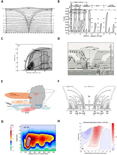
For over 100 years, it has been assumed that the tropical cyclone’s eye is dominated by sinking motion, which warms up the eye and enhances tropical cyclone intensity ((a)). However, few direct observations were available on vertical motion inside the tropical cyclone eye. Indirect observations from ozone measurements showed inconsistent results (Baray et al., Citation1999; Carsey & Willoughby, Citation2005; Collimore, Citation2018; Joiner et al., Citation2006; Newell et al., Citation1996; Penn, Citation1965, Citation1966; Rodgers et al., Citation1990; Stout & Rodgers, Citation1992; Zou & Wu, Citation2005). Using the global high-resolution ERA5 reanalysis collocated with satellite cloud and precipitation datasets, we found that tropical cyclone eyes with RMW > 50 km are in fact dominated by rising motion rather than sinking motion ((a and b)). The mean rising motion cools down the eye and could not explain the observed upper-level warm core. However, strong eddy updrafts and downdrafts exist inside the eye ((c)), which become stronger when the eyewall clouds grow in vertical extent. The stratospheric eddy downdrafts transport high enthalpy stratospheric air into the eye. Thermodynamic calculations show that a 4% intrusion of stratospheric hot air in the eye could explain the observed upper-level warm core. The stratospheric eddy downdrafts are not driven by convective hot towers penetrating into the stratosphere, but likely by divergence at the top of the eye. The observed tropical cyclone eye structure is summarized schematically in (b).
Fig. 14 Schematic depiction of tropical cyclone structure from (a) Emanuel (Citation2018), and (b) This study.
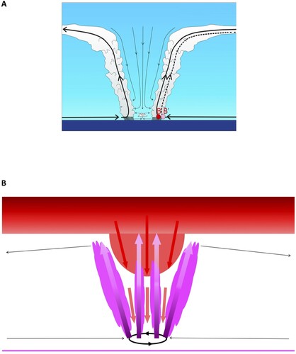
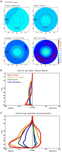
Fig. 15 (a) Composite mean vertical pressure velocity ω at 400 mb for northern hemisphere tropical cyclones with RMW > 50 km categorized by intensity: tropical depressions, tropical storms, category 1–2 hurricanes, and major (category 3–5) hurricanes. (b) Profiles of mean vertical velocity in tropical cyclone eyes. (c) Profiles of maximum updrafts and downdrafts in tropical cyclone eyes. Data are from ERA5 reanalysis for 1979–2015.
4 Tropical cyclone theories
Next, we review briefly tropical cyclone theories. Although there were many speculations in the seventeenth to nineteenth centuries on the physical mechanisms of tropical cyclones, such as the hypothesis that tropical cyclones are driven by chemical reactions in the ocean (Ellis, Citation1791), the schematic presented by Chevalier (Citation1893) may be considered the first descriptive model of a tropical cyclone ((b)). Amazingly, the Chevalier schematic is quite similar to today’s schematics with the surface low pressure and winds, tilted eyewall clouds, and sinking motion in the eye. Then in the early twentieth century, dry barotropic vortex models were developed for tropical cyclones (Fujiwhara, Citation1921; Rossby, Citation1948), which were used later in studying the tracks of tropical cyclones and interactions between binary cyclones (Holland & Dietachmayer, Citation1993; Kuo et al., Citation2008; Prieto et al., Citation2003; Ritchie & Holland, Citation1993).
Beginning in the 1950s, numerous tropical cyclone theories have been developed, which could be divided into seven groups, listed in the order from the spiral rainbands into the inner core and central eye: (1) wave/instability theories of the spiral rainbands, (2) theories of eyewall replacement cycles, (3) environmental forcing by upper-level troughs, (4) environmental forcing by wind shear, (5) balanced vortex theory of the inner core, (6) theories of maximum potential intensity, and (7) feedbacks between the moist convective vortex and the large-scale environment.
In the wave/instability theories of the spiral rainbands, atmospheric waves are used to explain the full structure of the tropical cyclone, including (1) inertia-gravity waves for the outer spiral rainbands, which could be forced from either inside or outside (Abdullah, Citation1966; Arakawa & Manabe, Citation1963; Kurihara, Citation1976; Lord Kelvin, Citation1887; Tepper, Citation1958; Willoughby, Citation1977, Citation1978a, Citation1978b, Citation1979); (2) Rossby waves for the eye region (Charney & Stern, Citation1962; Fjrtoft, Citation1950; Franklin et al., Citation2006; Guinn & Schubert, Citation1993; McDonald, Citation1968; Montgomery & Kallenbach, Citation1997; Schade, Citation1994), and (3) mixed Rossby-gravity waves for the eyewall region (Zhong et al., Citation2009). In the tropical atmosphere, convective coupling significantly reduces the equivalent depth and consequently slows down the phase speed of the waves (Lin et al., Citation2006; Wheeler & Kiladis, Citation1999). Other theories have attempted to explain spiral rainbands using Ekman layer instability (Faller, Citation1963; Fung, Citation1977; Lilly, Citation1966) or simply as a long-lived squall line (Robe & Emanuel, Citation2001; Rotunno et al., Citation1988).
Eyewall replacement cycles have been examined in numerous modelling studies, and many mechanisms have been proposed: (1) Montgomery and Kallenbach (Citation1997) proposed that outward propagating vortex Rossby waves, which converge at a stagnation radius, induce a secondary tangential wind maximum through wave-mean-flow interactions. However, Judt and Chen (Citation2010) presented a simulation of Hurricane Rita (2005) and showed that the presence of a moat region prevented the outward propagation of vortex Rossby waves. (2) Terwey and Montgomery (Citation2008) proposed that axisymmeterization and an upscale cascade of vorticity from rainband convection within a region associated with a weak radial gradient of vorticity, referred to as a “beta skirt”, could generate the second eyewall. (3) Fang and Zhang (Citation2012) proposed that stratiform downdrafts in the downwind direction create a lower-tropospheric frontal zone between the eyewall and rainband region, which facilitates the development of deep convection and a second eyewall. (4) Huang et al. (Citation2012) and Abarca and Montgomery (Citation2013) proposed that unbalanced dynamics leads to supergradient flow and ascent out of the boundary layer within a thermodynamically favourable location for convection. However, Kepert (Citation2013) concluded that supergradient flow is a byproduct of frictional convergence and a broad expansion of the tangential wind field does not necessarily cause a local frictional updraft. (5) Kepert (Citation2013) and Kepert and Nolan (Citation2014) proposed that feedback between the boundary layer response to a perturbation in the radial gradient of the gradient wind vorticity could generate the second eyewall. (6) External forcings are also suggested as drivers of the second eyewall, such as upper-level troughs (Dai et al., Citation2017; Molinari & Vollaro, Citation1990; Nong & Emanuel, Citation2003) and vertical wind shear (Dougherty et al., Citation2018; Zhang et al., Citation2017).
Environmental forcing by upper-level troughs has been assessed in many modelling studies (e.g. Challa et al., Citation1998; Challa & Pfeffer, Citation1980; Holland & Merrill, Citation1984; Komaromi & Doyle, Citation2018; Leroux et al., Citation2013, Citation2016; Molinari & Vollaro, Citation1990; Montgomery & Farrell, Citation1993; Nong & Emanuel, Citation2003; Pfeffer & Challa, Citation1981; Shi et al., Citation1997). The proposed physical mechanisms include an enhanced secondary circulation and convection by (1) eddy angular momentum flux, (2) quasi-geostrophic forcing, (3) potential vorticity forcing, and (4) jet-related upper-level divergence.
Environmental forcing by vertical wind shear has also been examined. The proposed physical mechanisms include (1) ventilation of environmental low-entropy air from the mid-level or boundary layer into the inner core (Cram et al., Citation2007; Riemer et al., Citation2010; Simpson & Riehl, Citation1958; Tang & Emanuel, Citation2010); (2) ventilation of upper-level high-entropy high-vorticity air out of the eye (Frank & Ritchie, Citation2001; Wong & Chan, Citation2004); (3) increasing the static stability of the inner core by an adiabatic midlevel warming response to vortex tilting (DeMaria, Citation1996; Wong & Chan, Citation2004); (4) eddy momentum fluxes opposing the symmetric overturning circulation (Wu & Braun, Citation2004); (5) increases of sensitivity to other environmental conditions such as mid-tropospheric humidity (Emanuel et al., Citation2004). The effects are also dependent on the height and depth of shear (Elsberry & Jeffries, Citation1996; Finocchio et al., Citation2016).
In the balanced vortex theories of the inner core, Eliassen (Citation1951) first demonstrated that for a balanced vortex driven by momentum and thermodynamic forcings, a compensating secondary circulation is needed to restore thermal wind balance. Balanced vortex dynamics has been used to model the secondary circulation in the inner core (Hack & Schubert, Citation1986; Navarro et al., Citation2017; Pendergrass & Willoughby, Citation2009; Schubert et al., Citation2007; Schubert & Hack, Citation1983; Shapiro & Willoughby, Citation1982; Smith et al., Citation2018; Smith & Wang, Citation2018; Sundqvist, Citation1970; Vigh & Schubert, Citation2009; Wang et al., Citation2020; Willoughby, Citation1988, Citation2009). The vertical structure of the heating plays a central role in these models. There was not observed heating profile for tropical cyclone eyewall at the time of Sundqvist (Citation1970) and the profile used was unrealistically top-heavy. Pendergrass and Willoughby (Citation2009) used a realistic heating structure based on observations. They found that the efficiency with which imposed heating intensifies the vortex is most sensitive to the intensity itself and the vortex size rather than the vortex shape or the forcing tilt.
The maximum potential intensity of tropical cyclones has been estimated by several studies from the available thermodynamic energy in the environment assuming that the detailed cyclone dynamics and internal processes provide no constraint on the maximum achievable intensity. The estimates are based on (1) parameterization of eye-region subsidence (Holland, Citation1997; Miller, Citation1958); (2) calculation of the available energy to balance surface momentum losses (Malkus & Riehl, Citation1960); and (3) assumption that a tropical cyclone acts as a classic Carnot heat engine (Bister & Emanuel, Citation1998; Emanuel, Citation1987, Citation1991; Emanuel et al., Citation2013; Kleinschmidt, Citation1951; Kowaleski & Evans, Citation2016; Smith et al., Citation2008).
Feedbacks between the moist convective vortex and the large-scale environment play a key role in tropical cyclone intensity change. In the earliest models, there was no convective parameterization and the vortex was amplified by large-scale condensation (Haque, Citation1952; Kasahara, Citation1961; Kuo, Citation1961; Lilly, Citation1960; Rosenthal, Citation1964; Syono, Citation1953; Yanai, Citation1961). Unrealistic grid-scale convection was often generated in those models, showing the need for a convection scheme (see review by Kuo, Citation1965). The first generation of convective parameterization emphasized moisture convergence, and the feedback mechanism was often called convective instability of the second kind (CISK; Charney & Eliassen, Citation1964; Kuo, Citation1965; Ooyama, Citation1964; Smith, Citation1997; Yamasaki, Citation1968). The second generation of convective parameterization added surface heat fluxes, and the feedback mechanism was often called wind-induced surface heat exchange (WISHE; Emanuel, Citation1986; Emanuel, Citation1995; Emanuel et al., Citation1994; Montgomery et al., Citation2009; Ooyama, Citation1969; Rosenthal, Citation1971; Rotunno & Emanuel, Citation1987). Later, effects of convective vorticity transport were also introduced (Hendricks et al., Citation2004; Montgomery et al., Citation2006; Nguyen et al., Citation2008; Smith et al., Citation2009).
Tropical cyclones also have an internal feedback with the stratosphere. A stronger tropical cyclone causes stronger cloud top outflow, and stronger cloud top outflow will drive stronger stratospheric downdrafts from above, which penetrate into the eye, increasing the eye temperature and causing intensification. These form a positive feedback loop for rapid intensification. Based on the physical thinking and observational evidence presented above, Lin and Qian developed a toy model with two components: a moist updraft to predict the cloud top of moist convection in the eyewall, and a dry downdraft to predict downward intrusion of stratospheric or tropospheric air in the eye. For both the updraft and downdraft, entrainment is considered with a simple fixed entrainment rate. The starting level of the dry downdraft is determined by the cloud top of the moist updraft, with a parameterization of suction layer depth and intrusion depth based on observations. A tropical cyclone’s central pressure is calculated from the resulting temperature profile in eye. The tendency of the maximum wind is then calculated from the pressure gradient force and the frictional force, with a parametrization of dependence of eye size on maximum wind (Holland et al., Citation2010; Knaff & Zehr, Citation2007; Kossin, Citation2015).
Intensification of the tropical cyclone is driven by warm stratospheric downdrafts forced by deep eyewall convection, and enhanced by positive feedbacks when the starting altitude and penetration depth of the warm stratospheric downdraft both increase with stronger intensity, while size of the eye shrinks with stronger intensity. Tests using a fixed eye size give similar results. Decay of tropical cyclones is caused by three physical mechanisms: suppression of eyewall deep convection by upper troposphere warming, vertical wind shear, and surface friction. The environmental temperature profile for the moist updraft is assumed to be the temperature profile in the eye. Therefore, warming of the upper troposphere by the warm stratospheric downdraft suppresses the cloud top height of the moist updraft at the next time step, leading to a negative feedback. Vertical wind shear is assumed to linearly decrease relative to the cloud top height of the moist updraft. Surface friction is parameterized following the observed dependence of the drag coefficient on tropical cyclone intensity, and tests using fixed drag coefficient give similar results. Our new tropical cyclone intensity model is tested with forecast experiments for 2877 tropical cyclones from 1979 to 2015 ((a)). Our model can predict well rapid intensification of extreme tropical cyclones, and can be compared with existing tropical cyclone forecast models (). Examples of forecast for individual events are shown for some of the deadliest and costliest tropical cyclones, such as Cyclone Nargis, Cyclone 02B, Super Typhoon Haiyan, Hurricane Mitch, Hurricane Katrina, and Hurricane Sandy ((b)).
Fig. 16 (A) Forecast skill of the Lin-Qian tropical cyclone intensity model for 2877 tropical cyclones from 1979 to 2015. (B) Examples of forecasts from the Lin-Qian tropical cyclone intensity model.
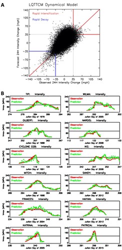
5 Summary and future directions
This paper reviews the history of tropical cyclone research from the late nineteenth century until the present day with an emphasis on observational studies. We reviewed research on tropical cyclone climatology, genesis indices, intraseasonal-to-centennial variability and trends, tropical cyclone structure, and tropical cyclone theory.
We would like to suggest the following future directions for research:
Study of extremely deadly cyclones in North Indian Ocean. The deadliest tropical cyclones of the past 40 years, Cyclone 02B and Cyclone Nargis, both resulting in ∼130,000 fatalities, happened in the North Indian Ocean. Unfortunately, research on cyclones in this region is very limited. There is an urgent need for in-depth research to help save lives in this highly-populated region.
Storm-scale high-resolution reanalysis. The latest ERA5 reanalysis has a 0.25° horizontal resolution and can resolve, for the first time, the eyes of tropical cyclones. A higher resolution reanalysis incorporating all aircraft reconnaissance data and other datasets would significantly improve our knowledge and understanding of tropical cyclone eye dynamics, and the physical mechanisms of rapid intensification.
Paleo-cyclone data for the past 2000 years. These data are important for an improved understanding of tropical cyclone variability associated with global climate change as well as decadal and multi-decadal variability. We suggest that an international project be developed to promote and integrate all of the research efforts currently being undertaken in different countries. The goal of this project would be the release of a high-quality inter-calibrated paleo-cyclone dataset.
New physics for genesis indices and maximum potential intensity models. As reviewed in Section 2.a, current indices exhibit large regional discrepancies, which can commonly reach up to ±50%. These indices also show an equatorward bias. New physical understanding is needed to improve genesis indices and maximum potential intensity models. These models are important for short-term and long-term forecasts of tropical cyclone activity.
Vortex-stratosphere feedback in tropical cyclone forecast models. Tropical cyclone intensity forecasts still lag behind tropical cyclone track forecasts in terms of forecast skills, which strongly affects decision making for evacuations and thus life and property losses. We believe that it is important to test the effects of vortex-stratosphere feedback on tropical cyclone intensity forecasts using operational forecasting models. Currently, the stratosphere is often coarsely treated in models. Improving the stratosphere in models may induce a more realistic vortex-stratosphere feedback, and better tropical cyclone intensity forecasts.
Tropical cyclones are one of the deadliest and costliest natural disasters on Earth. Right now, most of the Regional Specialized Meteorological Centers lack support for model development. It is important that government fundings are provided to support a limited number of highly qualified researchers, who could focus on model development and improving real-time forecast capability. Improved forecast skills will lead to reduction in fatality and property damage.
Acknowledgements
Part of this work was done by TQ when working in the Department of Geography, The Ohio State University. P. Klotzbach would like to acknowledge support from the G. Unger Vetlesen Foundation. We would like to thank Mike Chenoweth and Scott Power for sharing their reconstructed tropical cyclone activity datasets.
Disclosure statement
No potential conflict of interest was reported by the author(s).
References
- Abarca, S. F., & Montgomery, M. T. (2013). Essential dynamics of secondary eyewall formation. Journal of the Atmospheric Sciences, 70(10), 3216–3230. https://doi.org/10.1175/JAS-D-12-0318.1
- Abdullah, A. J. (1966). The spiral bands of a hurricane: a possible dynamic explanation. Journal of the Atmospheric Sciences, 23(4), 367–75. https://doi.org/10.1175/1520-0469(1966)023%3C0367:TSBOAH%3E2.0.CO;2
- Aiyyer, A., & Molinari, J. (2008). MJO and tropical cyclogenesis in the Gulf of Mexico and eastern Pacific: Case study and idealized numerical modeling. Journal of the Atmospheric Sciences, 65(8), 2691–2704. https://doi.org/10.1175/2007JAS2348.1
- Alvey, G. R., III, Zawislak, J., & Zipser, E. (2015). Precipitation properties observed during tropical cyclone intensity change. Monthly Weather Review, 143(11), 4476–4492. https://doi.org/10.1175/MWR-D-15-0065.1
- Andrews, D. G., & McIntyre, M. E. (1978). An exact theory of nonlinear waves on a Lagrangian mean flow. Journal of Fluid Mechanics, 89, 609–646. https://doi.org/10.1017/S0022112078002773
- Arakawa, H., & Manabe, D. (1963). Investigation of spiral rain bands and frontal structures in terms of shallow water waves. Papers of Meteorology and Geophysics, 14, 127–143. https://web.archive.org/web/20181103002253id_/https://www.jstage.jst.go.jp/article/mripapers1950/14/3-4/14_127/_pdf
- Atkinson, G. D., & Holliday, C. R. (1977). Tropical cyclone minimum sea level pressure/maximum sustained wind relationship for the western North Pacific. Monthly Weather Review, 105(4), 421–427. https://doi.org/10.1175/1520-0493(1977)105%3C0421:TCMSLP%3E2.0.CO;2
- Avila, L. A. (1991). Eastern North Pacific hurricane season of 1990. Monthly Weather Review, 119(8), 2034–2046. https://doi.org/10.1175/1520-0493(1991)119%3C2034:ENPHSO%3E2.0.CO;2
- Avila, L. A., & Pasch, R. J. (1992). Atlantic tropical systems of 1991. Monthly Weather Review, 120(11), 2688–2696. https://doi.org/10.1175/1520-0493(1992)120%3C2688:ATSO%3E2.0.CO;2
- Baray, J. L., Ancellet, G., Randriambelo, T., & Baldy, S. (1999). Tropical cyclone Marlene and stratosphere-troposphere exchange. Journal of Geophysical Research, 104(D11), 13953–13970. https://doi.org/10.1029/1999JD900028
- Barnes, G. M., & Powell, M. D. (1995). Evolution of the inflow boundary layer of Hurricane Gilbert (1988). Monthly Weather Review, 123(8), 2348–2368. https://doi.org/10.1175/1520-0493(1995)123%3C2348:EOTIBL%3E2.0.CO;2
- Barrett, B. S., & Leslie, L. M. (2009). Links between tropical cyclone activity and Madden-Julian oscillation phase in the North Atlantic and northeast Pacific basins. Monthly Weather Review, 137(2), 727–744. https://doi.org/10.1175/2008MWR2602.1
- Basher, R. E., & Zeng, X. (1995). Tropical cyclones in the southwest Pacific: Spatial patterns and relationships to Southern Oscillation and sea surface temperature. Journal of Climate, 8(5), 1249–1260. https://doi.org/10.1175/1520-0442(1995)008%3C1249:TCITSP%3E2.0.CO;2
- Bell, D. B., & Chelliah, M. (2006). Leading tropical modes associated with interannual and multidecadal fluctuations in North Atlantic hurricane activity. Journal of Climate, 19(4), 590–612. https://doi.org/10.1175/JCLI3659.1
- Bell, M. M., Montgomery, M. T., & Emanuel, K. A. (2012). Air-sea enthalpy and momentum exchange at major hurricane wind speeds observed during CBLAST. Journal of Atmospheric Sciences, 69(11), 3197–3222. https://doi.org/10.1175/JAS-D-11-0276.1
- Bergeron, T. (1954). The problem of tropical hurricanes. Quarterly Journal of the Royal Meteorological Society, 80(344), 131–64. https://doi.org/10.1002/qj.49708034402
- Bessafi, M., & Wheeler, M. (2006). Modulation of South Indian Ocean tropical cyclones by the Madden-Julian oscillation and convectively coupled equatorial waves. Monthly Weather Review, 134(2), 638–656. https://doi.org/10.1175/MWR3087.1
- Bhatia, K. T., Vecchi, G. A., Knutson, T. R., Murakami, H., Kossin, J., Dixon, K. W., & Whitlock, C. E. (2019). Recent increases in tropical cyclone intensification rates. Nature Communications, 10(1), 635. https://doi.org/10.1038/s41467-019-08471-z
- Birkel, S. D., Mayewski, P. A., Maasch, K. A., Kurbatov, A. V., & Lyon, B. (2018). Evidence for a volcanic underpinning of the Atlantic multidecadal oscillation. NPJ Climate and Atmospheric Science, 1(1), 24. https://doi.org/10.1038/s41612-018-0036-6
- Bister, M., & Emanuel, K. (1998). Dissipative heating and hurricane intensity. Meteorology and Atmospheric Physics, 65, 233–240. https://doi.org/10.1007/BF01030791
- Bjerknes, J. (1969). Atmospheric teleconnections from the equatorial Pacific. Monthly Weather Review, 97(3), 163–172. https://doi.org/10.1175/1520-0493(1969)097%3C0163:ATFTEP%3E2.3.CO;2
- Black, M. L., Burpee, R., & Marks, F., Jr. (1996). Vertical motion characteristics of tropical cyclones determined with airborne Doppler radial velocities. Journal of the Atmospheric Sciences, 53(13), 1887–1909. https://doi.org/10.1175/1520-0469(1996)053%3C1887:VMCOTC%3E2.0.CO;2
- Black, M. L., Gamache, J. F., Marks, F. D., Samsury, C. E., & Willoughby, H. E. (2002). Eastern Pacific Hurricanes Jimena of 1991 and Olivia of 1994: The effect of vertical shear on structure and intensity. Monthly Weather Review, 130(9), 2291–2312. https://doi.org/10.1175/1520-0493(2002)130%3C2291:EPHJOA%3E2.0.CO;2
- Black, M. L., & Willoughby, H. (1992). The concentric eyewall cycle of Hurricane Gilbert. Monthly Weather Review, 120(6), 947–957. https://doi.org/10.1175/1520-0493(1992)120%3C0947:TCECOH%3E2.0.CO;2
- Black, P. G., & Anthes, R. (1971). On the asymmetric structure of the tropical cyclone outflow layer. Journal of the Atmospheric Sciences, 28(8), 1348–1366. https://doi.org/10.1175/1520-0469(1971)028%3C1348:OTASOT%3E2.0.CO;2
- Black, P. G., D'Asaro, E. A., Drennan, W. M., French, J. R., Niiler, P. P., Sanford, T. B., Terrill, E. J., Walsh, E. J., & Zhang, J. A. (2007). Air-sea exchange in hurricanes: Synthesis of observations from the coupled boundary layer air-sea transfer experiment. Bulletin of the American Meteorological Society, 88(3), 357–374. https://doi.org/10.1175/BAMS-88-3-357
- Black, P. G., & Holland, G. (1995). The boundary layer of tropical cyclone Kerry (1979). Monthly Weather Review, 123(7), 2007–2028. https://doi.org/10.1175/1520-0493(1995)123%3C2007:TBLOTC%3E2.0.CO;2
- Black, R. A., & Hallett, J. (1999). Electrification of the hurricane. Journal of the Atmospheric Sciences, 56(12), 2004–2028. https://doi.org/10.1175/1520-0469(1999)056%3C2004:EOTH%3E2.0.CO;2
- Blackwell, K. G. (2000). The evolution of Hurricane Danny (1997) at landfall: Doppler-observed eyewall replacement, vortex contraction/intensification, and low-level wind maxima. Monthly Weather Review, 128(12), 4002–4016. https://doi.org/10.1175/1520-0493(2000)129%3C4002:TEOHDA%3E2.0.CO;2
- Bluestein, H. B., & Marks, F. D., Jr. (1987). On the structure of the eyewall of Hurricane “Diana” (1984): Comparison of radar and visual characteristics. Monthly Weather Review, 115(10), 2542–2552. https://doi.org/10.1175/1520-0493(1987)115%3C2542:OTSOTE%3E2.0.CO;2
- Bove, M. C., Elsner, J., Landsea, C., Niu, X., & O'Brien, J. (1998). Effect of El Nino on U.S. landfalling hurricanes, revisited. Bulletin of the American Meteorological Society, 79(11), 2477–2482. https://doi.org/10.1175/1520-0477(1998)079%3C2477:EOENOO%3E2.0.CO;2
- Bowie, E. H. (1921). The hurricane of October 25, 1921, at Tampa, FLA. Monthly Weather Review, 49(10), 567–570. https://doi.org/10.1175/1520-0493(1921)49%3C567:THOOAT%3E2.0.CO;2
- Bracken, W. E., & Bosart, L. (2000). The role of synoptic-scale flow during tropical cyclogenesis over the North Atlantic Ocean. Monthly Weather Review, 128(2), 353–376. https://doi.org/10.1175/1520-0493(2000)128%3C0353:TROSSF%3E2.0.CO;2
- Brand, S. (1970). Interaction of binary tropical cyclones of the western North Pacific Ocean. Journal of Applied Meteorology, 9(3), 433–441. https://doi.org/10.1175/1520-0450(1970)009%3C0433:IOBTCO%3E2.0.CO;2
- Braun, S. A., Archambault, H., Lin, I., Miyamoto, Y., Riemer, M., Rios-Berrios, R., Ritchie-Tyo, E., Sethurathinam, B., Shay, L., & Tang, B. (2018, December 3–7). Topic (3.2): Intensity change: External influences. Proceedings from the Ninth International Workshop on Tropical Cyclones (IWTC-9). 74 pp. https://www.wmo.int/pages/prog/arep/wwrp/tmr/documents/T3.2_report.pdf
- Briegel, L. M., & Frank, W. M. (1997). Large-scale influences on tropical cyclogenesis in the western North Pacific. Monthly Weather Review, 125, 1397–1413. https://doi.org/10.1175/1520-0493(1997)125%3C1397:LSIOTC%3E2.0.CO;2
- Brown, D. (2017). Tropical cyclone intensity forecasting: Still a challenging proposition. National Hurricane Center Presentation. https://www.nhc.noaa.gov/outreach/presentations/NHC2017_IntensityChallenges.pdf
- Bundgaard, R. C. (1958). The first flyover of a tropical cyclone. Weatherwise, 11(3), 79–83. https://doi.org/10.1080/00431672.1958.9925022
- Byers, H. R. (1944). General meteorology. McGrow Hill Book Comp.
- Callaghan, J., & Power, S. (2010). Variability and decline in the number of severe tropical cyclones making land-fall over eastern Australia since the late nineteenth century. Climate Dynamics, 37, 647–662. https://doi.org/10.1007/s00382-010-0883-2
- Camargo, S. J., Robertson, A., Gaffney, S., Smyth, P., & Ghil, M. (2007). Cluster analysis of typhoon tracks. Part II: Large-scale circulation and ENSO. Journal of Climate, 20(14), 3654–3676. https://doi.org/10.1175/JCLI4203.1
- Camargo, S. J., & Sobel, A. (2005). Western North Pacific tropical cyclone intensity and ENSO. Journal of Climate, 18(15), 2996–3006. https://doi.org/10.1175/JCLI3457.1
- Camargo, S. J., Wheeler, M., & Sobel, A. (2009). Diagnosis of the MJO modulation of tropical cyclogenesis using an empirical index. Journal of the Atmospheric Sciences, 66(10), 3061–3074. https://doi.org/10.1175/2009JAS3101.1
- Cangialosi, J. P. (2018). National Hurricane Center forecast verification report: 2018 hurricane season. National Hurricane Center. 73 pp. https://www.nhc.noaa.gov/verification/pdfs/Verification_2018.pdf
- Carless, T. G. (1849). Remarks on the Course of the Hurricane which occurred on the Malabar Coast, in April 1847. The Journal of the Royal Geographical Society of London, 19, 76–84. https://doi.org/10.2307/1798087
- Caron, L.-P., Boudreault, M., & Bruyere, C. (2015). Changes in large-scale controls of Atlantic tropical cyclone activity with the phases of the Atlantic multidecadal oscillation. Climate Dynamics, 44, 1801–1821. https://doi.org/10.1007/s00382-014-2186-5
- Carr, L. E., Boother, M., & Elsberry, R. (1997). Observational evidence for alternate modes of track-altering binary tropical cyclone scenarios. Monthly Weather Review, 125(9), 2094–2111. https://doi.org/10.1175/1520-0493(1997)125%3C2094:OEFAMO%3E2.0.CO;2
- Carr, L. E., III, & Elsberry, R. (1998). Objective diagnosis of binary tropical cyclone interactions for the western North Pacific basin. Monthly Weather Review, 126(6), 1734–1740. https://doi.org/10.1175/1520-0493(1998)126%3C1734:ODOBTC%3E2.0.CO;2
- Carsey, T. P., & Willoughby, H. (2005). Ozone measurements from eyewall transects of two Atlantic tropical cyclones. Monthly Weather Review, 133(1), 166–174. https://doi.org/10.1175/MWR-2844.1
- Cecil, D. J., & Zipser, E. (1999). Relationship between tropical cyclone intensity and satellite-based indicators of inner core convection: 85-GHz ice-scattering signature and lightning. Monthly Weather Review, 127(1), 103–123. https://doi.org/10.1175/1520-0493(1999)127%3C0103:RBTCIA%3E2.0.CO;2
- Challa, M., & Pfeffer, R. (1980). Effects of eddy fluxes of angular momentum on the model hurricane development. Journal of the Atmospheric Sciences, 37(7), 1603–1618. https://doi.org/10.1175/1520-0469(1980)037%3C1603:EOEFOA%3E2.0.CO;2
- Challa, M., Pfeffer, R., Zhao, Q., & Chang, S. (1998). Can eddy fluxes serve as a catalyst for hurricane and typhoon formation? Journal of the Atmospheric Sciences, 55(12), 2201–2219. https://doi.org/10.1175/1520-0469(1998)055%3C2201:CEFSAA%3E2.0.CO;2
- Chan, J. C. L. (1985). Tropical cyclone activity in the northwest Pacific in relation to the El Nino/Southern Oscillation phenomenon. Monthly Weather Review, 113(4), 599–606. https://doi.org/10.1175/1520-0493(1985)113%3C0599:TCAITN%3E2.0.CO;2
- Chan, J. C. L., & Shi, J. E. (2000). Frequency of typhoon landfall over Guangdong Province of China during the period 1470–1931. International Journal of Climatology, 20(2), 183–190. https://doi.org/10.1002/(SICI)1097-0088(200002)20:2%3C183::AID-JOC479%3E3.0.CO;2-U
- Chand, S. S., McBride, J., Tory, K., Wheeler, M., & Walsh, K. (2013). Impact of different ENSO regimes on Southwest Pacific tropical cyclones. Journal of Climate, 26(2), 600–608. https://doi.org/10.1175/JCLI-D-12-00114.1
- Chand, S. S., & Walsh, K. (2010). The influence of the Madden-Julian oscillation on tropical cyclone activity in the Fiji region. Journal of Climate, 23(4), 868–886. https://doi.org/10.1175/2009JCLI3316.1
- Charney, J. G., & Eliassen, A. (1964). On the growth of the hurricane depression. Journal of the Atmospheric Sciences, 21(1), 68–75. https://doi.org/10.1175/1520-0469(1964)021%3C0068:OTGOTH%3E2.0.CO;2
- Charney, J. G., & Stern, M. (1962). On the stability of internal baroclinic jets in a rotating atmosphere. Journal of the Atmospheric Sciences, 19(2), 159–172. https://doi.org/10.1175/1520-0469(1962)019%3C0159:OTSOIB%3E2.0.CO;2
- Chavas, D. R., Reed, K., & Knaff, J. (2017). Physical understanding of the tropical cyclone wind-pressure relationship. Nature Communications, 8, 1360. https://doi.org/10.1038/s41467-017-01546-9
- Chen, H.-F., Liu, Y.-C., Chiang, C.-W., Liu, X., Chou, Y.-M., & Pan, H.-J. (2019). China's historical record when searching for tropical cyclones corresponding to Intertropical Convergence Zone (ITCZ) shifts over the past 2 kyr. Climate of the Past, 15(1), 279–289. https://doi.org/10.5194/cp-15-279-2019
- Chen, H.-F., Wen, S.-Y., Song, S.-R., Yang, T.-N., Lee, T.-Q., Lin, S.-F., Hsu, S. C., Wei, K. Y., Chang, P. Y., & Yu, P. S. (2012). Strengthening of paleo-typhoon and autumn rainfall in Taiwan corresponding to the Southern Oscillation at late Holocene. Journal of Quaternary Science, 27(9), 964–972. https://doi.org/10.1002/jqs.2590
- Chen, S., Knaff, J. A., & Marks, F. D. (2006). Effects of vertical wind shear and storm motion on tropical cyclone rainfall asymmetries deduced from TRMM. Monthly Weather Review, 13(11), 3190–3208. https://doi.org/10.1175/MWR3245.1
- Chen, S. S., Zhao, W., Donelan, M., & Tolman, H. (2013). Directional wind-wave coupling in fully coupled atmosphere- wave-ocean models: Results from CBLAST-Hurricane. Journal of the Atmospheric Sciences, 70(10), 3198–3215. https://doi.org/10.1175/JAS-D-12-0157.1
- Chen, T.-C., Wang, S., Yen, M., & Gallus, W. (2004). Role of the monsoon gyre in the interannual variation of tropical cyclone formation over the western North Pacific. Weather and Forecasting, 19(4), 776–785. https://doi.org/10.1175/1520-0434(2004)019%3C0776:ROTMGI%3E2.0.CO;2
- Chen, X., Wang, Y., & Zhao, K. (2015). Synoptic flow patterns and large-scale characteristics associated with rapidly intensifying tropical cyclones in the South China Sea. Monthly Weather Review, 143(1), 64–87. https://doi.org/10.1175/MWR-D-13-00338.1
- Chenoweth, M. (2006). A reassessment of historical Atlantic basin tropical cyclone activity, 1700–1855. Climatic Change, 76(1–2), 169–240. https://doi.org/10.1007/s10584-005-9005-2
- Chenoweth, M., & Divine, D. (2008). A document-based 318-year record of tropical cyclones in the Lesser Antilles, 1690–2007. Geochemistry, Geophysics, Geosystems, 9(8), Q08013. https://doi.org/10.1029/2008GC002066
- Chenoweth, M., & Divine, D. (2012). Tropical cyclones in the Lesser Antilles: Descriptive statistics and historical variability in cyclone energy, 1638–2009. Climatic Change, 113(3-4), 583–598. https://doi.org/10.1007/s10584-011-0360-x
- Chevalier, S. (1893). The “Bokhara” typhoon, October 1892: Read before the Shanghai Meteorological Society, “North-China Herald” Office.
- Chia, H. H., & Ropelewski, C. (2002). The interannual variability in the genesis location of tropical cyclones in the north-west Pacific. Journal of Climate, 15(20), 2934–2944. https://doi.org/10.1175/1520-0442(2002)015%3C2934:TIVITG%3E2.0.CO;2
- Chu, J. H., Sampson, C. R., Levine, A. S., & Fukada, E. (2002). The joint typhoon warning centre tropical cyclone best-tracks, 1945–2000. https://www.metoc.navy.mil/jtwc/products/best-tracks/tc-bt-report.html
- Chu, P.-S. (2004). ENSO and tropical cyclone activity. In R. J. Murnane & K.-B. Liu (Eds.), Hurricanes and typhoons, past, present and future (pp. 297–332). Columbia University Press. https://www.soest.hawaii.edu/MET/Hsco/publications/2004.2.pdf
- Chu, P.-S., & Wang, J. (1997). Tropical cyclone occurrences in the vicinity of Hawaii: Are the differences between El Nino and non-El Nino years significant? Journal of Climate, 10(10), 2683–2689. https://doi.org/10.1175/1520-0442(1997)010%3C2683:TCOITV%3E2.0.CO;2
- Cione, J. J., Bryan, G. H., Dobosy, R., Zhang, J. A., de Boer, G., Aksoy, A., Wadler, J. B., Kalina, E. A., Dahl, B. A., Ryan, K., & Neuhaus, J. (2020). Eye of the storm: Observing hurricanes with a small unmanned aircraft system. Bulletin of the American Meteorological Society, 101(2), E186–E205. https://doi.org/10.1175/BAMS-D-19-0169.1
- Clark, J. D., & Chu, P. (2002). Interannual variation of tropical cyclone activity over the Central North Pacific. Journal of the Meteorological Society of Japan, 80(3), 403–418. https://doi.org/10.2151/jmsj.80.403
- Clement, A., Bellomo, K., Murphy, L., Cane, M., Mauritsen, T., Radel, G., & Stevens, B. (2015). The Atlantic multidecadal oscillation without a role for ocean circulation. Science, 350(6258), 320–324. https://doi.org/10.1126/science.aab3980
- Cline, I. M. (1915). The tropical hurricane of September 29, 1915, in Louisiana. Monthly Weather Review, 43(9), 456–473. https://doi.org/10.1175/1520-0493(1915)43%3C456:TTHOSI%3E2.0.CO;2
- Collimore, C. C. (2018). Revelations about tropical cyclones from A-Train satellite data: The effect of environmental aerosols on tropical cyclone formation, and the origin of ozone in the eyes of mature tropical cyclones [PhD dissertation, UCLA]. https://escholarship.org/uc/item/5c9767b8.
- Collins, J. M., Klotzbach, P. J., Maue, R., Roache, D., Blake, E., Paxton, C., & Mehta, C. (2016). The record-breaking 2015 hurricane season in the Eastern North Pacific: An analysis of environmental conditions. Geophysical Research Letters, 43, 9217–9224. https://doi.org/10.1002/2016GL070597
- Collins, J. M., & Mason, I. (2000). Local environmental conditions related to seasonal tropical cyclone activity in the Northeast Pacific basin. Geophysical Research Letters, 27(23), 3881–3884. https://doi.org/10.1029/2000GL011614
- Colon, J. A., & Nightingale, W. (1963). Development of tropical cyclones in relation to circulation patterns at the 200 millibar level. Monthly Weather Review, 91(7), 329–336. https://doi.org/10.1175/1520-0493(1963)091%3C0329:DOTCIR%3E2.3.CO;2
- Courtney, J., & Knaff, J. A. (2009). Adapting the Knaff and Zehr wind-pressure relationship for operational use in tropical cyclone warning centres. Australian Meteorological and Oceanographic Journal, 58, 167–179. http://www.bom.gov.au/jshess/docs/2009/courtney.pdf
- Courtney, J., Langlade, S., Sampson, C., Knaff, J., Birchard, T., Barlow, S., Kotal, S., Kriat, T., Lee, W., Pasch, R., & Shimada, U. (2019a). Operational perspectives on tropical cyclone intensity change. Part I: Recent advances in intensity guidance. Tropical Cyclone Research and Review, 8(3), 123–133. https://doi.org/10.1016/j.tcrr.2019.10.002
- Courtney, J., Langlade, S., Sampson, C., Knaff, J., Birchard, T., Barlow, S., Kotal, S., Kriat, T., Lee, W., Pasch, R., Shimada, U., & Singh, A. (2019b). Operational perspectives on tropical cyclone intensity change. Part II: Forecasts by operational agencies. Tropical Cyclone Research and Review, 8(4), 226–239. https://doi.org/10.1016/j.tcrr.2020.01.003
- Cram, T. A., Persing, J., Montgomery, M. T., & Braun, S. A. (2007). A Lagrangian trajectory view on transport and mixing processes between the eye, eyewall, and environment using a high-resolution simulation of Hurricane Bonnie (1998). Journal of the Atmospheric Sciences, 64(6), 1835–1856. https://doi.org/10.1175/JAS3921.1
- Dai, Y., Majumdar, S., & Nolan, D. (2017). Secondary eyewall formation in tropical cyclones by outflow-jet interaction. Journal of the Atmospheric Sciences, 74(6), 1941–1958. https://doi.org/10.1175/JAS-D-16-0322.1
- DeHart, J. C., Houze, R., & Rogers, R. F. (2014). Quadrant distribution of tropical cyclone inner-core kinematics in relation to environmental shear. Journal of the Atmospheric Sciences, 71(7), 2713–2732. https://doi.org/10.1175/JAS-D-13-0298.1
- Delworth, T. L., Zhang, L., Zhang, R., Vecchi, G., & Yang, X. (2017). The central role of ocean dynamics in connecting the North Atlantic Oscillation to the extratropical component of the Atlantic multidecadal oscillation. Journal of Climate, 30(10), 3789–3805. https://doi.org/10.1175/JCLI-D-16-0358.1
- DeMaria, M. (1996). The effect of vertical shear on tropical cyclone intensity change. Journal of the Atmospheric Sciences, 53(14), 2076–2087. https://doi.org/10.1175/1520-0469(1996)053%3C2076:TEOVSO%3E2.0.CO;2
- DeMaria, M., Baik, J., & Kaplan, J. (1993). Upper-level eddy angular momentum fluxes and tropical cyclone intensity change. Journal of the Atmospheric Sciences, 50, 1133–1147. https://doi.org/10.1175/1520-0469(1993)050%3C1133:ULEAMF%3E2.0.CO;2
- DeMaria, M., DeMaria, R., Knaff, J., & Molenar, D. (2012). Tropical cyclone lightning and rapid intensity change. Monthly Weather Review, 140(6), 1828–1842. https://doi.org/10.1175/MWR-D-11-00236.1
- DeMaria, M., Sampson, C., Knaff, J., & Musgrave, K. (2014). Is tropical cyclone intensity guidance improving? Bulletin of the American Meteorological Society, 95(3), 387–398. https://doi.org/10.1175/BAMS-D-12-00240.1
- Denommee, K. C., Bentley, S. J., & Droxler, A. W. (2014). Climatic controls on hurricane patterns: A 1200-y near-annual record from Lighthouse Reef, Belize. Scientific Reports, 4(1), 3876. https://doi.org/10.1038/srep03876
- Diamond, H. J., Lorrey, A. M., Knapp, K. R., & Levinson, D. H. (2012). Development of an enhanced tropical cyclone tracks database for the southwest Pacific from 1840 to 2010. International Journal of Climatology, 32, 2240–2250. https://doi.org/10.1002/joc.2412
- Didlake, A. C., Jr., Heymsfield, G. M., Reasor, P. D., & Guimond, S. R. (2017). Concentric eyewall asymmetries in Hurricane Gonzalo (2014) observed by airborne radar. Monthly Weather Review, 145(3), 729–749. https://doi.org/10.1175/MWR-D-16-0175.1
- Didlake, A. C., Jr., & Houze, R., Jr. (2011). Kinematics of the secondary eyewall observed in Hurricane Rita (2005). Journal of the Atmospheric Sciences, 68(8), 1620–1636. https://doi.org/10.1175/2011JAS3715.1
- Didlake, A. C., & Houze, R. (2013a). Convective-scale variations in the inner-core rainbands of a tropical cyclone. Journal of the Atmospheric Sciences, 70, 504–523. https://doi.org/10.1175/JAS-D-12-0134.1
- Didlake, A. C., & Houze, R. (2013b). Dynamics of the stratiform sector of a tropical cyclone rainband. Journal of the Atmospheric Sciences, 70, 1891–1911. https://doi.org/10.1175/JAS-D-12-0245.1
- Didlake, A. C., Jr., Reasor, P., Rogers, R., & Lee, W. (2018). Dynamics of the transition from spiral rainbands to a secondary eyewall in Hurricane Earl (2010). Journal of the Atmospheric Sciences, 75, 2909–2929. https://doi.org/10.1175/JAS-D-17-0348.1
- Dodge, P. P., Burpee, R., & Marks, F. (1999). The kinematic structure of a hurricane with sea level pressure less than 900 mb. Monthly Weather Review, 127, 987–1004. https://doi.org/10.1175/1520-0493(1999)127%3C0987:TKSOAH%3E2.0.CO;2
- Donelan, M. A., Haus, B. K., Reul, N., Plant, W. J., Stiassnie, M., Graber, H. C., Brown, O. B., & Saltzman, E. S. (2004). On the limiting aerodynamic roughness of the ocean in very strong winds. Geophysical Research Letters, 31, L18306. https://doi.org/10.1029/2004GL019460
- Dong, K. (1988). El Nino and tropical cyclone frequency in the Australian region and the North-western Pacific. Australian Meteorological Magazine, 36, 219–255.
- Dong, K., & Neuman, C. J. (1983). On the relative motion of binary tropical cyclones. Monthly Weather Review, 111(5), 945–953. https://doi.org/10.1175/1520-0493(1983)111%3C0945:OTRMOB%3E2.0.CO;2
- Donnelly, J. P., Bryant, S. S., Butler, J., Dowling, J., Fan, L., Hausmann, N., Newby, P. N., Shuman, B., Stern, J., Westover, K., & Webb, T. (2001). A 700-year sedimentary record of intense hurricane landfalls in Southern New England. Geological Society of America Bulletin, 113(6), 714–727. https://doi.org/10.1130/0016-7606(2001)113%3C0714:YSROIH%3E2.0.CO;2
- Donnelly, J. P., Hawkes, A. D., Lane, P., MacDonald, D., Shuman, B. N., Toomey, M. R., van Hengstum, P. J., & Woodruff, J. D. (2015). Climate forcing of unprecedented intense-hurricane activity in the last 2000 years. Earth's Future, 3, 49–65. https://doi.org/10.1002/2014EF000274
- Donnelly, J. P., Roll, S., Wengren, M., Butler, J., Lederer, R., & Webb, T. (2001). Sedimentary evidence of intense hurricane strikes from New Jersey. Geology, 29(7), 615–618. https://doi.org/10.1130/0091-7613(2001)029%3C0615:SEOIHS%3E2.0.CO;2
- Donnelly, J. P., & Woodruff, J. D. (2007). Intense hurricane activity over the past 5,000 years controlled by El Nino and the West African monsoon. Nature, 447, 465–468. https://doi.org/10.1038/nature05834
- Dougherty, E. M., Molinari, J., Rogers, R., Zhang, J., & Kossin, J. (2018). Hurricane Bonnie (1998): Maintaining intensity during high vertical wind shear and an eyewall replacement cycle. Monthly Weather Review, 146, 3383–3399. https://doi.org/10.1175/MWR-D-18-0030.1
- Drennan, W. M., Zhang, J., French, J., McCormick, C., & Black, P. (2007). Turbulent fluxes in the hurricane boundary layer. Part II: Latent heat flux. Journal of the Atmospheric Sciences, 64, 1103–1115. https://doi.org/10.1175/JAS3889.1
- Dunkerton, T. J., Montgomery, M., & Wang, Z. (2009). Tropical cyclogenesis in a tropical wave critical layer: Easterly waves. Atmospheric Chemistry and Physics, 9, 5587–5646. https://doi.org/10.5194/acp-9-5587-2009
- Dunn, G. E. (1940). Cyclogenesis in the tropical Atlantic. Bulletin of the American Meteorological Society, 21(6), 215–229. https://doi.org/10.1175/1520-0477-21.6.215
- Dvorak, V. F. (1975). Tropical cyclone intensity analysis and forecasting from satellite imagery. Monthly Weather Review, 103(5), 420–430. https://doi.org/10.1175/1520-0493(1975)103%3C0420:TCIAAF%3E2.0.CO;2
- Eliassen, A. (1951). Slow thermally or frictionally controlled meridional circulation in a circular vortex. Astrophisica Norvegica, 5, 18–60.
- Ellis, H. (1791). The Nature of a Hurricane Described, In An Original Letter From Governor Ellis, To Mr. J. S. The Literary Magazine and British Review, 7, 419–420. https://www.proquest.com/openview/c62613c652eef5dd/1?pq-origsite=gscholar&cbl=1665
- Elsberry, R. L., & Jeffries, R. (1996). Vertical wind shear influences on tropical cyclone formation and intensification during TCM-92 and TCM-93. Monthly Weather Review, 124(7), 1374–1387. https://doi.org/10.1175/1520-0493(1996)124%3C1374:VWSIOT%3E2.0.CO;2
- Elsner, J. B., & Kara, A. (1999). Hurricanes of the North Atlantic: Climate and Society. Oxford University Press. 488 pp.
- Elsner, J. B., Kossin, J., & Jagger, T. (2008). The increasing intensity of the strongest tropical cyclones. Nature, 455, 92–95. https://doi.org/10.1038/nature07234
- Elsner, K. B., & Liu, K. (2003). Examining the ENSO-typhoon hypothesis. Climate Research, 25(1), 43–54. doi:10.3354/cr025043
- Emanuel, K. (2005). Increasing destructiveness of tropical cyclones over the past 30 years. Nature, 436, 686–688. https://doi.org/10.1038/nature03906
- Emanuel, K. (2018). 100 years of progress in tropical cyclone research. Meteorological Monographs, 59, 15.1–15.68. https://doi.org/10.1175/AMSMONOGRAPHS-D-18-0016.1
- Emanuel, K. A. (1986). An air-sea interaction theory for tropical cyclones. Part I: Steady state maintenance. Journal of the Atmospheric Sciences, 43(6), 585–604. https://doi.org/10.1175/1520-0469(1986)043%3C0585:AASITF%3E2.0.CO;2
- Emanuel, K. A. (1987). The dependence of hurricane intensity on climate. Nature, 326, 483–485. https://doi.org/10.1038/326483a0
- Emanuel, K. A. (1991). The theory of hurricanes. Annual Review of Fluid Mechanics, 23, 179–196. https://doi.org/10.1146/annurev.fl.23.010191.001143
- Emanuel, K. A. (1995). The behavior of a simple hurricane model using a convective scheme based on subcloud-layer entropy equilibrium. Journal of the Atmospheric Sciences, 52(22), 3960–3968. https://doi.org/10.1175/1520-0469(1995)052%3C3960:TBOASH%3E2.0.CO;2
- Emanuel, K. A. (2003). Tropical cyclones. Annual Review of Earth and Planetary Sciences, 31, 75–104. https://doi.org/10.1146/annurev.earth.31.100901.141259
- Emanuel, K. A., DesAutels, C., Holloway, C., & Korty, R. (2004). Environmental control of tropical cyclone intensity. Journal of the Atmospheric Sciences, 61(7), 843–858. https://doi.org/10.1175/1520-0469(2004)061%3C0843:ECOTCI%3E2.0.CO;2
- Emanuel, K. A., Neelin, J., & Bretherton, C. (1994). On large-scale circulations in convecting atmospheres. Quarterly Journal of the Royal Meteorological Society, 120, 1111–1143. https://doi.org/10.1002/qj.49712051902
- Emanuel, K. A., & Nolan, D. S. (2004). Tropical cyclone activity and global climate. In Proceedings of 26th Conference on Hurricanes and Tropical Meteorology (pp. 240–241). American Meteorological Society.
- Emanuel, K., Solomon, S., Folini, D., Davis, S., & Cagnazzo, C. (2013). Influence of tropical tropopause layer cooling on Atlantic hurricane activity. Journal of Climate, 26(7), 2288–2301. https://doi.org/10.1175/JCLI-D-12-00242.1
- Evans, J. L., & Allan, R. (1992). El Nino/Southern Oscillation modification to the structure of the monsoon and tropical cyclone activity in the Australian region. International Journal of Climatology, 12(6), 611–623. https://doi.org/10.1002/joc.3370120607
- Faller, A. (1963). An experimental study of the instability of the laminar Ekman boundary layer. Journal of Fluid Mechanics, 15, 560–576. https://doi.org/10.1017/S0022112063000458
- Fang, J., & Zhang, F. (2012). Effect of beta shear on simulated tropical cyclones. Monthly Weather Review, 140(10), 3327–3346. https://doi.org/10.1175/MWR-D-10-05021.1
- Fassig, O. L. (1928). San Felipe-the hurricane of September 13, 1928, at San Juan, P.R. Monthly Weather Review, 56(9), 350–352. https://doi.org/10.1175/1520-0493(1928)56%3C350:SFHOSA%3E2.0.CO;2
- Fernandez-Partagas, J., & Diaz, H. F. (1996). Atlantic Hurricanes in the second half of the nineteenth century. Bulletin of the American Meteorological Society, 77(12), 2899–2906. https://doi.org/10.1175/1520-0477(1996)077%3C2899:AHITSH%3E2.0.CO;2
- Ferreira, R. N., Schubert, W. H., & Hack, J. J. (1996). Dynamical aspects of twin tropical cyclones associated with the Madden–Julian oscillation. Journal of the Atmospheric Sciences, 53(7), 929–945. https://doi.org/10.1175/1520-0469(1996)0530929:DAOTTC2.0.CO;2
- Fett, R. W. (1966). Upper-level structure of the formative tropical cyclone. Monthly Weather Review, 94(1), 9–18. https://doi.org/10.1175/1520-0493(1966)094%3C0009:ULSOTF%3E2.3.CO;2
- Finocchio, P. M., Majumdar, S., Nolan, D., & Iskandarani, M. (2016). Idealized tropical cyclone responses to the height & depth of environmental vertical wind shear. Monthly Weather Review, 144(6), 2155–2175. https://doi.org/10.1175/MWR-D-15-0320.1
- Fischer, M., Rogers, R., & Reasor, P. (2020). The rapid intensification and eyewall replacement cycles of Hurricane Irma (2017). Monthly Weather Review, 148(3), 981–1004. https://doi.org/10.1175/MWR-D-19-0185.1
- Fischer, M. S., Tang, B., & Corbosiero, K. (2017). Assessing the influence of upper-tropospheric troughs on tropical cyclone intensification rates after genesis. Monthly Weather Review, 145(4), 1295–1313. https://doi.org/10.1175/MWR-D-16-0275.1
- Fischer, M. S., Tang, B., & Corbosiero, K. (2019). A climatological analysis of tropical cyclone rapid intensification in environments of upper-tropospheric troughs. Monthly Weather Review, 147(10), 3693–3719. https://doi.org/10.1175/MWR-D-19-0013.1
- Fjrtoft, R. (1950). Application of integral theorems in deriving criteria of stability for laminar flows and for the baroclinic circular vortex. Geofysiske Publikasjoner, 17, 1–52. http://ngfweb.no/docs/NGF_GP_Vol17_no6.pdf
- Fletcher, R. D., Smith, J. R., & Bundgaard, R. C. (1961). Superior photographic reconnaissance of tropical cyclones. Weatherwise, 14(3), 102–109. https://doi.org/10.1080/00431672.1961.9930014
- Fortner, L. E. (1958). Typhoon Sarah, 1956. Bulletin of the American Meteorological Society, 39(12), 633–639. https://doi.org/10.1175/1520-0477-39.12.633
- Frank, W. M. (1977a). Structure and energetics of the tropical cyclone: I. Storm structure. Monthly Weather Review, 105(9), 1119–1135. https://doi.org/10.1175/1520-0493(1977)105%3C1119:TSAEOT%3E2.0.CO;2
- Frank, W. M. (1977b). Structure and energetics of the tropical cyclone: II. Dynamics and energetics. Monthly Weather Review, 105(9), 1136–1150. https://doi.org/10.1175/1520-0493(1977)105%3C1136:TSAEOT%3E2.0.CO;2
- Frank, W. M., & Ritchie, E. (2001). Effects of vertical wind shear on the intensity and structure of numerically simulated hurricanes. Monthly Weather Review, 129(9), 2249–2269. https://doi.org/10.1175/1520-0493(2001)129%3C2249:EOVWSO%3E2.0.CO;2
- Franklin, C. N., Holland, G., & May, P. (2006). Mechanisms for the generation of vorticity features in tropical cyclone rainbands. Monthly Weather Review, 134(10), 2649–2669. https://doi.org/10.1175/MWR3222.1
- Franklin, J. L., Black, M. L., & Valde, K. (2003). GPS dropwindsonde profiles in hurricanes and their operational implications. Weather and Forecasting, 18(1), 32–44. https://doi.org/10.1175/1520-0434(2003)018%3C0032:GDWPIH%3E2.0.CO;2
- French, J. R., Drennan, W., Zhang, J., & Black, P. (2007). Turbulent fluxes in the hurricane boundary layer. Part I: Momentum flux. Journal of the Atmospheric Sciences, 64(4), 1089–1102. https://doi.org/10.1175/JAS3887.1
- Fritz, H. M., Blount, C. D., Thwin, S., Thu, M. K., & Chan, N. (2009). Cyclone Nargis storm surge in Myanmar. Nature Geoscience, 2, 448–449. https://doi.org/10.1038/ngeo558
- Fujita, T., Watanabe, K., & Izawa, T. (1969). Formation and structure of equatorial anticyclones caused by large-scale cross-equatorial flow determined by ATS-I photographs. Journal of Applied Meteorology, 8(4), 649–667. https://doi.org/10.1175/1520-0450(1969)008%3C0649:FASOEA%3E2.0.CO;2
- Fujiwhara, S. (1921). The natural tendency towards symmetry of motion and its application as a principle in meteorology. Quarterly Journal of the Royal Meteorological Society, 47, 287–292. https://doi.org/10.1002/qj.49704720010
- Fung, I. Y.-S. (1977). The organization of spiral rainbands in a hurricane [Sc.D. thesis, MIT]. 140 pp. https://dspace.mit.edu/bitstream/handle/1721.1/16337/04078908-MIT.pdf?sequence=2
- Gamache, J. F., Houze, R., Jr., & Marks, F. (1993). Dual-aircraft investigation of the inner core of Hurricane Norbert. Part III: Water budget. Journal of the Atmospheric Sciences, 50(19), 3221–3243. https://doi.org/10.1175/1520-0469(1993)050%3C3221:DAIOTI%3E2.0.CO;2
- Garcia-Herrera, R., Barriopedro, D., Gallego, D., Mellado-Cano, J., Wheeler, D., & Wilkinson, C. (2018). Understanding weather and climate of the last 300 years from ships’ logbooks. Wires Climate Change. https://doi.org/10.1002/wcc.54
- Garcia-Herrera, R., Gimeno, L., Ribera, P., & Hernandez, E. (2005). New records of Atlantic hurricanes from Spanish documentary sources. Journal of Geophysical Research - Atmospheres, 110, D03109. https://doi.org/10.1029/2004JD005272
- Garriott, E. B. (1898). The West Indian hurricane of September 29-October 2. Monthly Weather Review, 26(10), 439–440.
- Giammanco, I. M., Schroeder, J., & Powell, M. (2012). Observed characteristics of tropical cyclone vertical wind profiles. Wind and Structures, 15(1), 1–22. https://doi.org/10.12989/was.2012.15.1.065
- Girishkumar, M. S., & Ravichandran, M. (2012). The influences of ENSO on tropical cyclone activity in the Bay of Bengal during October–December. Journal of Geophysical Research, 117, C02033. https://doi.org/10.1029/2011JC007417
- Goldenberg, S. B., Landsea, C. W., Mestas-Nunez, A. M., & Gray, W. M. (2001). The recent increase in Atlantic hurricane activity: Causes and implications. Science, 293(5529), 474–479. https://doi.org/10.1126/science.1060040
- Goldenberg, S. B., & Shapiro, L. (1996). Physical mechanisms for the association of El Niño and West Africa rainfall with Atlantic major hurricanes. Journal of Climate, 9(6), 1169–87. https://doi.org/10.1175/1520-0442(1996)0091169:PMFTAO2.0.CO;2
- Gray, W. M. (1968). Global view of the origin of tropical disturbances and storms. Monthly Weather Review, 96(10), 669–700. https://doi.org/10.1175/1520-0493(1968)096%3C0669:GVOTOO%3E2.0.CO;2
- Gray, W. M. (1975). Tropical cyclone genesis. Colorado State University, Department of Atmospheric Sciences Paper, 234, 121 pp.
- Gray, W. M. (1979). Hurricanes: their formation, structure and likely role in the tropical circulation. In B. Shaw (Ed.), Meteorology over the tropical oceans (pp. 155–218). Royal Meteorological Society Publication.
- Gray, W. M. (1984). Atlantic seasonal hurricane frequency. Part I: El Nino and 30 mb quasi-biennial oscillation influences. Monthly Weather Review, 112(9), 1649–1668. https://doi.org/10.1175/1520-0493(1984)112%3C1649:ASHFPI%3E2.0.CO;2
- Gray, W. M. (1998). The formation of tropical cyclones. Meteorology and Atmospheric Physics, 67, 37–69. https://doi.org/10.1007/BF01277501
- Gray, W. M., Landsea, C., MielkeJr.P., & Berry, K. (1993). Predicting Atlantic basin seasonal tropical cyclone activity by 1 August. Weather and Forecasting, 8(1), 73–86. https://doi.org/10.1175/1520-0434(1993)008%3C0073:PABSTC%3E2.0.CO;2
- Gray, W. M., & Sheaffer, J. (1991). El Nino and QBO influences on tropical cyclone activity. In M. H. Glantz, R. W. Katz, & N. Nicholls (Eds.), Teleconnections linking worldwide anomalies (pp. 257–284). Cambridge University Press.
- Guimond, S. R., Heymsfield, G., Reasor, P., & Didlake, A. (2016). The rapid intensification of Hurricane Karl (2010): New remote sensing observations of convective bursts from the Global Hawk platform. Journal of the Atmospheric Sciences, 73(9), 3617–3639. https://doi.org/10.1175/JAS-D-16-0026.1
- Guimond, S. R., Heymsfield, G., & Turk, F. (2010). Multiscale observations of Hurricane Dennis (2005): The effects of hot towers on rapid intensification. Journal of the Atmospheric Sciences, 67(3), 633–654. https://doi.org/10.1175/2009JAS3119.1
- Guinn, T. A., & Schubert, W. H. (1993). Hurricane spiral bands. Journal of the Atmospheric Sciences, 50(20), 3380–403. https://doi.org/10.1175/1520-0469(1993)050%3C3380:HSB%3E2.0.CO;2
- Hack, J. J., & Schubert, W. (1986). Nonlinear response of atmospheric vortices to heating by organized cumulus convection. Journal of the Atmospheric Sciences, 43(15), 1559–1573. https://doi.org/10.1175/1520-0469(1986)043%3C1559:NROAVT%3E2.0.CO;2
- Haig, J., Nott, J., & Reichart, G. (2014). Australian tropical cyclone activity lower than at any time over the past 550–1,500 years. Nature, 505, 667–671. https://doi.org/10.1038/nature12882
- Hall, J. D., Matthews, A., & Karoly, D. (2001). The modulation of tropical cyclone activity in the Australian region by the Madden-Julian oscillation. Monthly Weather Review, 129(12), 2970–2982. https://doi.org/10.1175/1520-0493(2001)129%3C2970:TMOTCA%3E2.0.CO;2
- Halverson, J. B., Simpson, J., Heymsfield, G., Pierce, H., Hock, T., & Ritchie, L. (2006). Warm core structure of Hurricane Erin diagnosed from high altitude dropsondes during CAMEX-4. Journal of the Atmospheric Sciences, 63(1), 309–324. https://doi.org/10.1175/JAS3596.1
- Hankes, I., Wang, Z., Zhang, G., & Fritz, C. (2015). Merger of African easterly waves and formation of Cape Verde storms. Quarterly Journal of the Royal Meteorological Society, 141(689), 1306–1319. https://doi.org/10.1002/qj.2439
- Hanley, D., Molinari, J., & Keyser, D. (2001). A composite study of the interactions between tropical cyclones and upper-tropospheric troughs. Monthly Weather Review, 129(10), 2570–2584. https://doi.org/10.1175/1520-0493(2001)129%3C2570:ACSOTI%3E2.0.CO;2
- Haque, S. M. A. (1952). Initial of cyclonic circulation in a vertically unstable stagnant air mass. Quarterly Journal of the Royal Meteorological Society, 78, 394–406. https://doi.org/10.1002/qj.49707833710
- Harper, B. A. (2002). Tropical cyclone parameter estimation and the Australian region: Wind-pressure relationships and related issues for engineering planning and design – a discussion paper. Systems Engineering Australia Report J0106- PR003E, 83 pp.
- Harr, P. A., Elsberry, R., & Chan, J. (1996). Transformation of a large monsoon depression to a tropical storm during TCM-93. Monthly Weather Review, 124(12), 2625–2643. https://doi.org/10.1175/1520-0493(1996)124%3C2625:TOALMD%3E2.0.CO;2
- Hastings, P. A. (1990). Southern Oscillation influences on tropical cyclone activity in the Australian/South-west Pacific region. International Journal of Climatology, 10(3), 291–298. https://doi.org/10.1002/joc.3370100306
- Haurwitz, B. (1935). The height of tropical cyclones and of the “eye” of the storm. Monthly Weather Review, 63, 45–49.
- Haurwitz, B. (1951). The motion of binary cyclones. Archiv für Meteorologie, Geophysik und Bioklimatologie. Serie A, 4, 73–86. https://doi.org/10.1007/BF02246794
- Hawkins, H. F., & Imbembo, S. (1976). The structure of a small, intense hurricane, Inez 1966. Monthly Weather Review, 104(4), 418–442. https://doi.org/10.1175/1520-0493(1976)104%3C0418:TSOASI%3E2.0.CO;2
- Hawkins, H. F., & Rubsam, D. (1968). Hurricane Hilda, 1964. 2. Structure and budgets of the hurricane on October 1, 1964. Monthly Weather Review, 96(9), 617–636. https://doi.org/10.1175/1520-0493(1968)096%3C0617:HH%3E2.0.CO;2
- Hawkins, J. D., Helveston, M., Lee, T., Turk, F., Richardson, K., Sampson, C., Kent, J., & Wade, R. (2006). Tropical cyclone multiple eyewall characteristics. Preprints, 27th Conference on Hurricane and Tropical Meteorology, American Meteorological Society, 6B.1. http://ams.confex.com/ams/27Hurricanes/techprogram/paper_108864.htm
- Hence, D. A., & Houze, R., Jr. (2012). Vertical structure of tropical cyclones with concentric eyewalls as seen by the TRMM Precipitation Radar. Journal of the Atmospheric Sciences, 69(3), 1021–1036. https://doi.org/10.1175/JAS-D-11-0119.1
- Hendricks, E. A., Braun, S. A., Vigh, J. L., & Courtney, J. B. (2019). A summary of research advances on tropical cyclone intensity change from 2014–2018. Tropical Cyclone Research and Review, 8(4), 219–225. https://doi.org/10.1016/j.tcrr.2020.01.002
- Hendricks, E. A., Montgomery, M., & Davis, C. (2004). The role of “vortical” hot towers in the formation of Tropical Cyclone Diana (1984). Journal of the Atmospheric Sciences, 61(11), 1209–1232. https://doi.org/10.1175/1520-0469(2004)061%3C1209:TROVHT%3E2.0.CO;2
- Heymsfield, G. M., Tian, L., Heymsfield, A., Li, L., & Guimond, S. (2010). Characteristics of deep tropical and subtropical convection from nadir-viewing high-altitude airborne Doppler radar. Journal of the Atmospheric Sciences, 67(2), 285–308. https://doi.org/10.1175/2009JAS3132.1
- Ho, C.-H., Kim, J., Jyong, J., Kim, H., & Chen, D. (2006). Variation of tropical cyclone activity in the south Indian Ocean: El Nino-Southern Oscillation and Madden-Julian oscillation effects. Journal of Geophysical Research, 111, D22101. https://doi.org/10.1029/2006JD007289
- Hock, T. F., & Franklin, J. L. (1999). The NCAR GPS dropwindsonde. Bulletin of the American Meteorological Society, 80(3), 407–420. https://doi.org/10.1175/1520-0477(1999)080%3C0407:TNGD%3E2.0.CO;2
- Holland, G. J. (1995). Scale interaction in the Western Pacific Monsoon. Meteorology and Atmospheric Physics, 56, 57–79. https://doi.org/10.1007/BF01022521
- Holland, G. J. (1997). The maximum potential intensity of tropical cyclones. Journal of the Atmospheric Sciences, 54(21), 2519–2541. https://doi.org/10.1175/1520-0469(1997)054%3C2519:TMPIOT%3E2.0.CO;2
- Holland, G. J., Belanger, J., & Fritz, A. (2010). A revised model for radial profiles of hurricane winds. Monthly Weather Review, 138(12), 4393–4406. https://doi.org/10.1175/2010MWR3317.1
- Holland, G. J., & Dietachmayer, G. (1993). On the interaction of tropical-cyclone-scale vortices. III: Continuous barotropic vortices. Quarterly Journal of the Royal Meteorological Society, 119(514), 1381–1398. https://doi.org/10.1002/qj.49711951408
- Holland, G. J., & Merrill, R. (1984). On the dynamics of tropical cyclone structural changes. Quarterly Journal of the Royal Meteorological Society, 110(465), 723–745. https://doi.org/10.1002/qj.49711046510
- Holliday, C. R. (1977). Double intensification of Typhoon Gloria, 1974. Monthly Weather Review, 105(4), 523–528. https://doi.org/10.1175/1520-0493(1977)105%3C0523:DIOTG%3E2.0.CO;2
- Holthuijsen, L. H., Powell, M., & Pietrzak, J. (2012). Wind and waves in extreme hurricanes. Journal of Geophysical Research, 117, C09003. https://doi.org/10.1029/2012JC007983
- Hoose, H. M., & Colon, J. (1970). Some aspects of the radar structure of Hurricane Beulah on September 9, 1967. Monthly Weather Review, 98(7), 529–533. https://doi.org/10.1175/1520-0493(1970)098%3C0529:SAOTRS%3E2.3.CO;2
- Hoover, E. W. (1961). Relative motion of hurricane pairs. Monthly Weather Review, 89(7), 251–255. https://doi.org/10.1175/1520-0493(1961)089%3C0251:RMOHP%3E2.0.CO;2
- Hopsch, S. B., Thorncroft, C., & Tyle, K. (2010). Analysis of African easterly wave structures and their role in influencing tropical cyclogenesis. Monthly Weather Review, 138(4), 1399–1419. https://doi.org/10.1175/2009MWR2760.1
- Houze, R. A. (1982). Cloud clusters and large-scale vertical motions in the Tropics. Journal of Meteorological Society of Japan, 60, 396–410. https://doi.org/10.2151/jmsj1965.60.1_396
- Houze, R. A., Chen, S., Smull, B., Lee, W., & Bell, M. (2007). Hurricane intensity and eyewall replacement. Science, 315(5816), 1235–1239. https://doi.org/10.1126/science.1135650
- Houze, R. A., Jr., Lee, W., & Bell, M. (2009). Convective contribution to the genesis of Hurricane Ophelia (2005). Monthly Weather Review, 137(9), 2778–2800. https://doi.org/10.1175/2009MWR2727.1
- Houze, R. A., Marks, F., Jr., & Black, R. (1992). Dual-aircraft investigation of the inner core of Hurricane Norbert. Part II: Mesoscale distribution of ice particles. Journal of the Atmospheric Sciences, 49(11), 943–963. https://doi.org/10.1175/1520-0469(1992)049%3C0943:DAIOTI%3E2.0.CO;2
- Hsu, J.-Y., Lien, R.-C., D'asaro, E. A., & Sanford, T. B. (2017). Estimates of surface wind stress and drag coefficients in Typhoon Megi. Journal of Physical Oceanography, 47(3), 545–565. https://doi.org/10.1175/JPO-D-16-0069.1
- Huang, L., Li, X., Liu, B., Zhang, J. A., Shen, D., Zhang, Z., & Yu, W. (2018). Tropical cyclone boundary layer rolls in synthetic aperture radar imagery. Journal of Geophysical Research: Oceans, 123(4), 2981–2996. https://doi.org/10.1029/2018JC013755
- Huang, Y., Montgomery, M., & Wu, C. (2012). Concentric eyewall formation in Typhoon Sinlaku (2008). Part II: Axisymmetric dynamical processes. Journal of the Atmospheric Sciences, 69(2), 662–674. https://doi.org/10.1175/JAS-D-11-0114.1
- Huang, Y., Wu, C., & Montgomery, M. (2018). Concentric eyewall formation in Typhoon Sinlaku (2008). Part III: Horizontal momentum budget analyses. Journal of the Atmospheric Sciences, 75(10), 3541–3563. https://doi.org/10.1175/JAS-D-18-0037.1
- Irwin, R. P., & Davis, R. (1999). The relationship between the Southern Oscillation Index and tropical cyclone tracks in the eastern North Pacific. Geophysical Research Letters, 26, 2251–2254. https://doi.org/10.1029/1999GL900533
- Jang, W., & Chun, H. (2015). Characteristics of binary tropical cyclones observed in the western North Pacific for 62 years (1951–2012). Monthly Weather Review, 143(5), 1749–1761. https://doi.org/10.1175/MWR-D-14-00331.1
- Jarosz, E., Mitchell, D. A., Wang, D. W., & Teague, W. J. (2007). Bottom-up determination of air-sea momentum exchange under a major tropical cyclone. Science, 315(5819), 1707–1709. https://doi.org/10.1126/science.1136466
- Jarvinen, B. R., Neumann, C., & Davis, M. (1984). A tropical cyclone data tape for the North Atlantic Basin, 1886–1983: Contents, limitations, and uses. NOAA Technical Memorandum NWS NHC 22, 21 pp. https://repository.library.noaa.gov/view/noaa/7069/noaa_7069_DS1.pdf
- Jiang, H., & Ramirez, E. (2013). Necessary conditions for tropical cyclone rapid intensification as derived from 11 years of TRMM data. Journal of Climate, 26(17), 6459–6470. https://doi.org/10.1175/JCLI-D-12-00432.1
- Joiner, J., Vasilkov, A., Yang, K., & Bhartia, P. (2006). Observations over hurricanes from the ozone monitoring instrument. Geophysical Research Letters, 33, L06807. https://doi.org/10.1029/2005GL025592
- Jordan, C. L. (1959). A reported sea level pressure of 877 mb. Monthly Weather Review, 87(9), 365–366. https://doi.org/10.1175/1520-0493(1959)087%3C0365:WNARSL%3E2.0.CO;2
- Jordan, C. L. (1961). Marked changes in the characteristics of the eye of intense typhoons between the deepening and filling stages. Journal of the Atmospheric Sciences, 18(6), 779–789. https://doi.org/10.1175/1520-0469(1961)018%3C0779:MCITCO%3E2.0.CO;2
- Jordan, C. L. (1966). Surface pressure variations at coastal stations during the period of irregular motion of Hurricane Carla of 1961. Monthly Weather Review, 94(7), 454–458. https://doi.org/10.1175/1520-0493(1966)094%3C0454:SPVACS%3E2.3.CO;2
- Jordan, C. L., & Schatzle, F. (1961). The “double eye” of Hurricane Donna. Monthly Weather Review, 89(9), 354–356. https://doi.org/10.1175/1520-0493(1961)089%3C0354:WNTDEO%3E2.0.CO;2
- Jorgensen, D. P. (1984a). Mesoscale and convective-scale characteristics of mature hurricanes. Part I: General observations by research aircraft. Journal of the Atmospheric Sciences, 41(8), 1268–1285. https://doi.org/10.1175/1520-0469(1984)041%3C1268:MACSCO%3E2.0.CO;2
- Jorgensen, D. P. (1984b). Mesoscale and convective-scale characteristics of mature hurricanes. Part II: Inner core structure of Hurricane Allen (1980). Journal of the Atmospheric Sciences, 41(8), 1287–1311. https://doi.org/10.1175/1520-0469(1984)041%3C1287:MACSCO%3E2.0.CO;2
- Jorgensen, D. P., Zipser, E. J., & LeMone, M. (1985). Vertical motions in intense hurricanes. Journal of the Atmospheric Sciences, 42(8), 839–56. https://doi.org/10.1175/1520-0469(1985)042%3C0839:VMIIH%3E2.0.CO;2
- Judt, F., & Chen, S. (2010). Convectively generated potential vorticity in rainbands and formation of the secondary eyewall in Hurricane Rita of 2005. Journal of the Atmospheric Sciences, 67(11), 3581–3599. https://doi.org/10.1175/2010JAS3471.1
- Kasahara, A. (1961). A numerical experiment on the development of a tropical cyclone. Journal of the Atmospheric Sciences, 18(3), 259–282. https://doi.org/10.1175/1520-0469(1961)018%3C0259:ANEOTD%3E2.0.CO;2
- Kepert, J. D. (2006a). Observed boundary layer wind structure and balance in the hurricane core. Part I: Hurricane Georges. Journal of the Atmospheric Sciences, 63(9), 2169–2193. https://doi.org/10.1175/JAS3745.1
- Kepert, J. D. (2006b). Observed boundary layer wind structure and balance in the hurricane core. Part II: Hurricane Mitch. Journal of the Atmospheric Sciences, 63(9), 2194–2211. https://doi.org/10.1175/JAS3746.1
- Kepert, J. D. (2013). How does the boundary layer contribute to eyewall replacement cycles in axisymmetric tropical cyclones? Journal of the Atmospheric Sciences, 70(9), 2808–2830. https://doi.org/10.1175/JAS-D-13-046.1
- Kepert, J. D., & Nolan, D. (2014). Reply to comments on how does the boundary layer contribute to eyewall replacement cycles in axisymmetric tropical cyclones? Journal of the Atmospheric Sciences, 71(12), 4692–4704. https://doi.org/10.1175/JAS-D-14-0014.1
- Kikuchi, K., & Wang, B. (2010). Formation of tropical cyclones in the northern Indian Ocean associated with two types of tropical intraseasonal oscillation modes. Journal of the Meteorological Society of Japan, 88(3), 475–496. https://doi.org/10.2151/jmsj.2010-313
- Kim, J.-H., Ho, C., Kim, H., Sui, C., & Park, S. (2008). Systematic variation of summertime tropical cyclone activity in the western North Pacific in relation to the Madden-Julian oscillation. Journal of Climate, 21(6), 1171–1191. https://doi.org/10.1175/2007JCLI1493.1
- KimBall, J. H. (1915). A pacific hurricane of September, 1915. Monthly Weather Review, 43(9), 486. https://doi.org/10.1175/1520-0493(1915)43%3C486:APHOS%3E2.0.CO;2
- Kimball, S. K., & Mulekar, M. S. (2004). A 15-year climatology of North Atlantic tropical cyclones. Part I: Size parameters. Journal of Climate, 17(18), 3555–3575. https://doi.org/10.1175/1520-0442(2004)017%3C3555:AYCONA%3E2.0.CO;2
- Kleinschmidt, E., Jr. (1951). Grundlagen einer theorie der tropischen zyklonen. Archiv für Meteorologie, Geophysik und Bioklimatologie, Serie A, 4, 53–72. https://doi.org/10.1007/BF02246793
- Klotzbach, P. J. (2010). On the Madden-Julian oscillation-Atlantic hurricane relationship. Journal of Climate, 23(2), 282–293. https://doi.org/10.1175/2009JCLI2978.1
- Klotzbach, P. J. (2011). The influence of El Nino-Southern Oscillation and the Atlantic multidecadal oscillation on Caribbean Tropical cyclone activity. Journal of Climate, 24(3), 721–731. https://doi.org/10.1175/2010JCLI3705.1
- Klotzbach, P. J. (2012). El Nino-Southern Oscillation, the Madden-Julian oscillation and Atlantic basin tropical cyclone rapid intensification. Journal of Geophysical Research, 117, D14104. https://doi.org/10.1029/2012JD017714
- Klotzbach, P. J. (2014). The Madden-Julian Oscillation's impacts on worldwide tropical cyclone activity. Journal of Climate, 27(6), 2317–2330. https://doi.org/10.1175/JCLI-D-13-00483.1
- Klotzbach, P. J., & Blake, E. (2013). North-central Pacific tropical cyclones: Impacts of El Nino-Southern oscillation and the Madden-Julian oscillation. Journal of Climate, 26(19), 7720–7733. https://doi.org/10.1175/JCLI-D-12-00809.1
- Klotzbach, P. J., Bowen, S., Pielke, R., Jr., & Bell, M. (2018). Continental United States landfall frequency and associated damage: Observations and future risks. Bulletin of the American Meteorological Society, 99(7), 1359–1376. https://doi.org/10.1175/BAMS-D-17-0184.1
- Klotzbach, P. J., & Gray, W. (2008). Multidecadal variability in North Atlantic tropical cyclone activity. Journal of Climate, 21(15), 3929–3935. https://doi.org/10.1175/2008JCLI2162.1
- Klotzbach, P. J., & Landsea, C. (2015). Extremely intense hurricanes: Revisiting Webster et al. (2005) after 10 years. Journal of Climate, 28(19), 7621–7629. https://doi.org/10.1175/JCLI-D-15-0188.1
- Klotzbach, P. J., & Oliver, E. (2015). Modulation of Atlantic basin tropical cyclone activity by the Madden-Julian oscillation (MJO) from 1905 to 2011. Journal of Climate, 28(1), 204–217. https://doi.org/10.1175/JCLI-D-14-00509.1
- Knaff, J. A. (1997). Implications of summertime sea level pressure anomalies in the tropical Atlantic region. Journal of Climate, 10(4), 789–804. https://doi.org/10.1175/1520-0442(1997)010%3C0789:IOSSLP%3E2.0.CO;2
- Knaff, J. A., Longmore, S. P., & Molenar, D. A. (2014). An objective satellite-based tropical cyclone size climatology. Journal of Climate, 27(1), 455–476. https://doi.org/10.1175/JCLI-D-13-00096.1
- Knaff, J. A., & Zehr, R. (2007). Reexamination of tropical cyclone wind-pressure relationships. Weather and Forecasting, 22(1), 71–88. https://doi.org/10.1175/WAF965.1
- Knapp, K. R., Kruk, M., Levinson, D., Diamond, H., & Neumann, C. (2010). The International Best Track Archive for Climate Stewardship (IBTrACS): Unifying tropical cyclone best track data. Bulletin of the American Meteorological Society, 91(3), 363–376. https://doi.org/10.1175/2009BAMS2755.1
- Knapp, K. R., Vimont, D., Murnane, R., & Harper, B. (2007). A globally consistent reanalysis of hurricane variability and trends. Geophysical Research Letters, 34, L04815. https://doi.org/10.1029/2006GL028836
- Knight, J. R., Folland, C. K., & Scaife, A. A. (2006). Climate impacts of the Atlantic multidecadal oscillation. Geophysical Research Letters, 33, L17706. https://doi.org/10.1029/2006GL026242
- Knudsen, M. F., Jacobsen, B. H., Seidenkrantz, M. S., & Olsen, J. (2014). Evidence for external forcing of the Atlantic multidecadal oscillation since termination of the little Ice Age. Nature Communications, 5, 3323. https://doi.org/10.1038/ncomms4323
- Knupp, K. R., Walters, J., & Biggerstaff, M. (2006). Doppler radar and profiler observations of boundary layer variability during the landfall of Tropical Storm Gabrielle. Journal of the Atmospheric Sciences, 63(1), 243–251. https://doi.org/10.1175/JAS3608.1
- Knutson, T., Camargo, S., Chan, J., Emanuel, K., Ho, C., Kossin, J., Mohapatra, M., Satoh, M., Sugi, M., Walsh, K., & Wu, L. (2019). Tropical cyclones and climate change assessment: Part I: Detection and attribution. Bulletin of the American Meteorological Society, 100(10), 1987–2007. https://doi.org/10.1175/BAMS-D-18-0189.1
- Knutson, T., Camargo, S., Chan, J., Emanuel, K., Ho, C., Kossin, J., Mohapatra, M., Satoh, M., Sugi, M., Walsh, K., & Wu, L. (2020). Tropical cyclones and climate change assessment: Part II: Projected response to anthropogenic warming. Bulletin of the American Meteorological Society, 101(3), E303–E322. https://doi.org/10.1175/BAMS-D-18-0194.1
- Knutson, T. R., Landsea, C., & Emanuel, K. (2010). Tropical cyclones and climate change: A review. Nature Geoscience, 3, 157–163. https://doi.org/10.1038/ngeo779
- Koba, H., Hagiwara, T., Asano, S., & Akashi, S. (1990). Relationships between CI number from Dvorak's technique and minimum sea level pressure or maximum wind speed of tropical cyclone (in Japanese). Journal of Meteorological Research, 42, 59–67.
- Komaromi, W. A., & Doyle, J. (2018). On the dynamics of tropical cyclone and trough interactions. Journal of the Atmospheric Sciences, 75(8), 2687–2709. https://doi.org/10.1175/JAS-D-17-0272.1
- Kossin, J. P. (2015). Hurricane wind-pressure relationship and eyewall replacement cycles. Weather and Forecasting, 30(1), 177–181. https://doi.org/10.1175/WAF-D-14-00121.1
- Kossin, J. P. (2018). A global slowdown of tropical cyclone translation speed. Nature, 558, 104–108. https://doi.org/10.1038/s41586-018-0158-3
- Kossin, J. P., Emanuel, K., & Vecchi, G. (2014). The poleward migration of the location of tropical cyclone maximum intensity. Nature, 509, 349–352. https://doi.org/10.1038/nature13278
- Kossin, J. P., Olander, T., & Knapp, K. (2013). Trend analysis with a new global record of tropical cyclone intensity. Journal of Climate, 26(24), 9960–9976. https://doi.org/10.1175/JCLI-D-13-00262.1
- Kossin, J. P., & Sitkowski, M. (2009). An objective model for identifying secondary eyewall formation in hurricanes. Monthly Weather Review, 137(3), 876–892. https://doi.org/10.1175/2008MWR2701.1
- Kossin, J. P., & Vimont, D. (2007). A more general framework for understanding Atlantic hurricane variability and trends. Bulletin of the American Meteorological Society, 88(11), 1767–1781. https://doi.org/10.1175/BAMS-88-11-1767
- Kowaleski, A. M., & Evans, J. L. (2016). A reformulation of tropical cyclone potential intensity theory incorporating energy production along a radial trajectory. Monthly Weather Review, 144(10), 3569–3578. https://doi.org/10.1175/MWR-D-15-0383.1
- Krishnamohan, K. S., Mohanakumar, K., & Joseph, P. (2012). The influence of Madden-Julian oscillation in the genesis of north Indian Ocean tropical cyclones. Theoretical and Applied Climatology, 109, 271–282. https://doi.org/10.1007/s00704-011-0582-x
- Kubota, H., & Chan, J. (2009). Interdecadal variability of tropical cyclone landfall in the Philippines from 1902 to 2005. Geophysical Research Letters, 36, L12802. https://doi.org/10.1029/2009GL038108
- Kuo, H.-C., Chang, C., Yang, Y., & Jiang, H. (2009). Western North Pacific typhoons with concentric eyewalls. Monthly Weather Review, 137(11), 3758–3770. https://doi.org/10.1175/2009MWR2850.1
- Kuo, H.-C., Schubert, W., Tsai, C., & Kuo, Y. (2008). Vortex interactions and barotropic aspects of concentric eyewall formation. Monthly Weather Review, 136(12), 5183–5198. https://doi.org/10.1175/2008MWR2378.1
- Kuo, H.-L. (1965). On formation and intensification of tropical cyclones through latent heat release by cumulus convection. Journal of the Atmospheric Sciences, 22(1), 40–63. https://doi.org/10.1175/1520-0469(1965)022%3C0040:OFAIOT%3E2.0.CO;2
- Kuo, H. L. (1961). Convection in conditionally unstable atmosphere. Tellus, 13(4), 441–459. https://doi.org/10.1111/j.2153-3490.1961.tb00107.x
- Kurihara, Y. (1976). On the development of spiral bands in a tropical cyclone. Journal of the Atmospheric Sciences, 33(6), 940–958. https://doi.org/10.1175/1520-0469(1976)033%3C0940:OTDOSB%3E2.0.CO;2
- Lander, M. A. (1994). Description of a monsoon gyre and its effects on the tropical cyclones in the western North Pacific during August 1991. Weather and Forecasting, 9(4), 640–654. https://doi.org/10.1175/1520-0434(1994)009%3C0640:DOAMGA%3E2.0.CO;2
- Lander, M. A. (1995). The merger of two tropical cyclones. Monthly Weather Review, 123(7), 2260–2265. https://doi.org/10.1175/1520-0493(1995)123%3C2260:TMOTTC%3E2.0.CO;2
- Lander, M., & Holland, G. (1993). On the interaction of tropical-cyclone-scale vortices. I: Observations. Quarterly Journal of the Royal Meteorological Society, 119(514), 1347–1361. https://doi.org/10.1002/qj.49711951406
- Landsea, C. W. (1993). A climatology of intense (or major) Atlantic hurricanes. Monthly Weather Review, 121(6), 1703–1713. https://doi.org/10.1175/1520-0493(1993)121%3C1703:ACOIMA%3E2.0.CO;2
- Landsea, C. W. (2007). Counting Atlantic tropical cyclones back to 1900. Eos, Transactions American Geophysical Union, 88(8), 197–202. https://doi.org/10.1029/2007EO180001
- Landsea, C. W., Anderson, C., Charles, N., Clark, G., Dunion, J., Fernandez-Partagas, J., Hungerford, P., Neumann, C., & Zimmer, M. (2004). The Atlantic hurricane database reanalysis project: Documentation for the 1851–1910 alterations and additions to the HURDAT database. In R. J. Murnane & K.-B. Liu (Eds.), Hurricanes and typhoons: Past, present, and future (pp. 177–221). Columbia University Press.
- Landsea, C. W., & Franklin, J. (2013). Atlantic hurricane database uncertainty and presentation of a new database format. Monthly Weather Review, 141(10), 3576–3592. https://doi.org/10.1175/MWR-D-12-00254.1
- Landsea, C. W., Harper, B., Hoarau, K., & Knaff, J. (2006). Can we detect trends in extreme tropical cyclones? Science, 313, 452–454. https://doi.org/10.1126/science.1128448
- LaSeur, N. E., & Hawkins, H. (1963). An analysis of Hurricane Cleo (1958) based on data from research reconnaissance aircraft. Monthly Weather Review, 91(10), 694–709. https://doi.org/10.1175/1520-0493(1963)091%3C0694:AAOHCB%3E2.3.CO;2
- Lee, C.-S., Edson, R., & Gray, W. (1989). Some large-scale characteristics associated with tropical cyclone development in the north Indian Ocean during FGGE. Monthly Weather Review, 117(2), 407–426. https://doi.org/10.1175/1520-0493(1989)117%3C0407:SLSCAW%3E2.0.CO;2
- Lee, C.-Y., & Chen, S. (2012). Symmetric and asymmetric structures of hurricane boundary layer in coupled atmosphere-wave-ocean models and observations. Journal of the Atmospheric Sciences, 69(12), 3576–3594. https://doi.org/10.1175/JAS-D-12-046.1
- Lee, C. S. (1989a). Observational analysis of tropical cyclogenesis in the Western North Pacific. Part I: Structural evolution of cloud clusters. Journal of the Atmospheric Sciences, 46(16), 2580–2598. https://doi.org/10.1175/1520-0469(1989)046%3C2580:OAOTCI%3E2.0.CO;2
- Lee, C. S. (1989b). Observational analysis of tropical cyclogenesis in the Western North Pacific. Part II: Budget analysis. Journal of the Atmospheric Sciences, 46(16), 2599–2616. https://doi.org/10.1175/1520-0469(1989)046%3C2599:OAOTCI%3E2.0.CO;2
- Leppert, K. D., Cecil, D., & Petersen, W. (2013a). Relation between tropical easterly waves, convection, and tropical cyclogenesis: A Lagrangian perspective. Monthly Weather Review, 141(8), 2649–2668. https://doi.org/10.1175/MWR-D-12-00217.1
- Leppert, K. D., Petersen, W., & Cecil, D. (2013b). Electrically active convection in tropical easterly waves and implications for tropical cyclogenesis in the Atlantic and east Pacific. Monthly Weather Review, 141(2), 542–556. https://doi.org/10.1175/MWR-D-12-00174.1
- Leroux, M.-D., Plu, M., Barbary, D., Roux, F., & Arbogast, P. (2013). Dynamical and physical processes leading to tropical cyclone intensification under upper-level trough forcing. Journal of the Atmospheric Sciences, 70(8), 2547–2565. https://doi.org/10.1175/JAS-D-12-0293.1
- Leroux, M.-D., Plu, M., & Roux, F. (2016). On the sensitivity of tropical cyclone intensification under upper-level trough forcing. Monthly Weather Review, 144(3), 1179–1202. https://doi.org/10.1175/MWR-D-15-0224.1
- Leroy, A., & Wheeler, M. (2008). Statistical prediction of weekly tropical cyclone activity in the Southern Hemisphere. Monthly Weather Review, 136(10), 3637–3654. https://doi.org/10.1175/2008MWR2426.1
- Li, R. C. Y., & Zhou, W. (2013). Modulation of western North Pacific tropical cyclone activity by the ISO. Part I: Genesis and intensity. Journal of Climate, 26(9), 2904–2918. https://doi.org/10.1175/JCLI-D-12-00210.1
- Li, S. (1936). Untersuchunger ϋber Taifune. Veröffentlichungen des Meterologyischen Instituts der Vniversitä Berlin, Band I, Heft 5.
- Liebmann, B., Hendon, H. H., & Glick, J. D. (1994). The relationship between tropical cyclones of the western Pacific and Indian Ocean and the Madden-Julian oscillation. Journal of the Meteorological Society of Japan, 72(3), 401–412. https://doi.org/10.2151/jmsj1965.72.3_401
- Lilly, D. K. (1960). On the theory of disturbances in a conditionally unstable atmosphere. Monthly Weather Review, 88(1), 1–17. https://doi.org/10.1175/1520-0493(1960)088%3C0001:OTTODI%3E2.0.CO;2
- Lilly, D. K. (1966). On the instability of Ekman boundary flow. Journal of the Atmospheric Sciences, 23(5), 481–494. https://doi.org/10.1175/1520-0469(1966)023%3C0481:OTIOEB%3E2.0.CO;2
- Lin, J.-L., Kiladis, G. N., Mapes, B. E., Weickmann, K. M., Sperber, K. R., Lin, W., Wheeler, M. C., Schubert, S. D., Del Genio, A., Donner, L. J., & Emori, S. (2006). Tropical intraseasonal variability in 14 IPCC CMIP3 climate models. Part I: Convective signals. Journal of Climate, 19(12), 2665–2690. https://doi.org/10.1175/JCLI3735.1
- Lin, J. L., & Qian, T. (2019). Switch between El Nino and La Nina is caused by subsurface ocean waves likely driven by lunar tidal forcing. Nature Scientific Reports. https://doi.org/10.1038/s41598-019-49678-w
- Liu, K.-B., & Fearn, M. L. (1993). Lake-sediment record of late Holocene hurricane activities from coastal Alabama. Geology, 21, 793–796. https://doi.org/10.1130/0091-7613(1993)021%3C0793:LSROLH%3E2.3.CO;2
- Liu, K.-B., & Fearn, M. L. (2000). Reconstruction of prehistoric landfall frequencies of catastrophic hurricanes in northwestern Florida from lake sediment records. Quaternary Research, 54, 238–245. https://doi.org/10.1006/qres.2000.2166
- Liu, K. B., Shen, C., & Louie, K. S. (2001). A 1,000 year history of typhoon landfalls in Guangdong, Southern China, Reconstructed from Chinese historical documentary records. Annals of the Association of American Geographers, 91, 453–464. https://doi.org/10.1111/0004-5608.00253
- Lord Kelvin (Sir William Thomson). (1887). On the waves produced by a single impulse in water of any depth, or in a dispersive medium. Proceedings of the Royal Society of London, 42, 80–87. https://doi.org/10.1098/rspl.1887.0017
- Lorsolo, S., Schroeder, J. L., Dodge, P., & Marks, F., Jr. (2008). An observational study of hurricane boundary layer small-scale coherent structures. Monthly Weather Review, 136(8), 2871–2893. https://doi.org/10.1175/2008MWR2273.1
- Louie, K., & Liu, K. (2003). Earliest historical records of typhoons in China. Journal of Historical Geography, 29, 299–316. https://doi.org/10.1006/jhge.2002.0453
- Love, G. (1985a). Cross equatorial influence of winter hemisphere subtropical cold surges. Monthly Weather Review, 113(9), 1487–1498. https://doi.org/10.1175/1520-0493(1985)113%3C1487:CEIOWH%3E2.0.CO;2
- Love, G. (1985b). Cross equatorial interactions during tropical cyclogenesis. Monthly Weather Review, 113(9), 1499–1509. https://doi.org/10.1175/1520-0493(1985)113%3C1499:CEIDTC%3E2.0.CO;2
- Love, G., & Murphy, K. (1985). The operational analysis of tropical cyclone wind fields in the Australian northern region (pp. 44–51). Northern Territory Region Research Papers 1984-85. Bureau of Meteorology.
- Ludlum, D. M. (1963). Early American hurricanes, 1492–1870. American Meteorological Society. 198 pp.
- Lussier, L. L., III, Montgomery, M. T., & Bell, M. M. (2014). The genesis of Typhoon Nuri as observed during the Tropical Cyclone Structure 2008 (TCS-08) field experiment – Part 3: Dynamics of low-level spin-up during the genesis. Atmospheric Chemistry and Physics, 14, 8795–8812. https://doi.org/10.5194/acp-14-8795-2014
- Madden, R. A., & Julian, P. (1971). Detection of a 40-50 day oscillation in the zonal wind in the tropical Pacific. Journal of the Atmospheric Sciences, 28(5), 702–708. https://doi.org/10.1175/1520-0469(1971)028%3C0702:DOADOI%3E2.0.CO;2
- Magee, A. D., Verdon-Kidd, D., Diamond, H., & Kiem, A. (2017). Influence of ENSO, ENSO Modoki, and the IPO on tropical cyclogenesis: A spatial analysis of the southwest Pacific region. International Journal of Climatology, 37, 1118–1137. https://doi.org/10.1002/joc.5070
- Malkus, J. S., & Riehl, H. (1960). On the dynamics and energy transformations in steady-state hurricanes. Tellus, 12, 1–20. https://doi.org/10.3402/tellusa.v12i1.9351
- Maloney, E. D., & Hartmann, D. (2000a). Modulation of eastern North Pacific hurricanes by the Madden-Julian oscillation. Journal of Climate, 13(9), 1451–1460. https://doi.org/10.1175/1520-0442(2000)013%3C1451:MOENPH%3E2.0.CO;2
- Maloney, E. D., & Hartmann, D. (2000b). Modulation of hurricane activity in the Gulf of Mexico by the Madden-Julian oscillation. Science, 287, 2002–2004. https://doi.org/10.1126/science.287.5460.2002
- Mann, M., Steinman, B., Brouillette, D., & Miller, S. (2021). Multidecadal climate oscillations during the past millennium driven by volcanic forcing. Science, 371, 1014–1019. https://doi.org/10.1126/science.abc5810
- Mann, M., Steinman, B., & Miller, S. (2020). Absence of internal multidecadal and interdecadal oscillations in climate model simulations. Nature Communications, 11, 49. https://doi.org/10.1038/s41467-019-13823-w
- Marks, F. D., Jr. (1985). Evolution of the structure of precipitation in Hurricane Allen (1980). Monthly Weather Review, 113(6), 909–930, https://doi.org/10.1175/1520-0493(1985)113,0909EOTSOP.2.0.CO;2
- Marks, F. D., & Houze, R. (1984). Airborne Doppler radar observations in Hurricane Debby. Bulletin of American Meteorological Society, 65(6), 569–582. https://doi.org/10.1175/1520-0477(1984)065%3C0569:ADROIH%3E2.0.CO;2
- Marks, F. D., Jr., & Houze, R., Jr. (1987). Inner core structure of Hurricane Alicia from airborne Doppler radar observations. Journal of the Atmospheric Sciences, 44(9), 1296–1317. https://doi.org/10.1175/1520-0469(1987)044%3C1296:ICSOHA%3E2.0.CO;2
- Marks, F. D., Jr., Houze, R., Jr., & Gamache, J. (1992). Dual-aircraft investigation of the inner core of Hurricane Norbert. Part I: Kinematic structure. Journal of the Atmospheric Sciences, 49(11), 919–942. https://doi.org/10.1175/1520-0469(1992)049%3C0919:DAIOTI%3E2.0.CO;2
- McBride, J. L. (1981). Observational analysis of tropical cyclone formation. Part III: Budget analysis. Journal of the Atmospheric Sciences, 38(6), 1152–1166. https://doi.org/10.1175/1520-0469(1981)038%3C1152:OAOTCF%3E2.0.CO;2
- McBride, J. L., & Keenan, T. (1982). Climatology of tropical cyclone genesis in the Australian region. Journal of Climatology, 2, 13–33. https://doi.org/10.1002/joc.3370020103
- McBride, J. L., & Zehr, R. (1981). Observational analysis of tropical cyclone formation. Part II: Comparison of non-developing versus developing systems. Journal of the Atmospheric Sciences, 38(6), 1132–1151. https://doi.org/10.1175/1520-0469(1981)038%3C1132:OAOTCF%3E2.0.CO;2
- McDonald, N. J. (1968). The evidence for the existence of Rossby-like waves in the hurricane vortex. Tellus, 20, 138–50. https://doi.org/10.1111/j.2153-3490.1968.tb00358.x
- McNoldy, B. D. (2004). Triple eyewall in Hurricane Juliette. Bulletin of the American Meteorological Society, 85, 1663–1666. https://doi.org/10.1175/BAMS-85-11-1657
- Mei, W., & Xie, S. (2016). Intensification of landfalling typhoons over the northwest Pacific since the late 1970s. Nature Geoscience, 9, 753–757. https://doi.org/10.1038/ngeo2792
- Menkes, C. E., Lengaigne, E., Marchesiello, P., Jourdain, N., Vincent, E., Lefevre, J., Chauvin, F., & Royer, J. (2012). Comparison of tropical cyclogenesis indices on seasonal to interannual timescales. Climate Dynamics, 38, 301–321. https://doi.org/10.1007/s00382-011-1126-x
- Merrill, R. T. (1984). A comparison of large and small tropical cyclones. Monthly Weather Review, 112(7), 1408–1418. https://doi.org/10.1175/1520-0493(1984)112%3C1408:ACOLAS%3E2.0.CO;2
- Merrill, R. T. (1988a). Characteristics of the upper-tropospheric environmental flow around hurricanes. Journal of the Atmospheric Sciences, 45(11), 1665–1677. https://doi.org/10.1175/1520-0469(1988)045%3C1665:COTUTE%3E2.0.CO;2
- Merrill, R. T. (1988b). Environmental influences on hurricane intensification. Journal of the Atmospheric Sciences, 45(11), 1678–1687. https://doi.org/10.1175/1520-0469(1988)045%3C1678:EIOHI%3E2.0.CO;2
- Millas, C. J. (1968). Hurricanes of the Caribbean and adjacent regions, 1492–1800. Academy of the Arts and Sciences of the Americas. 328 pp.
- Miller, B. I. (1958). On the maximum intensity of hurricanes. Journal of the Atmospheric Sciences, 15(2), 184–195. https://doi.org/10.1175/1520-0469(1958)015%3C0184:OTMIOH%3E2.0.CO;2
- Miller, B. I. (1964). A study of the filling of hurricane Donna over land (1960). Monthly Weather Review, 92(9), 389–406. https://doi.org/10.1175/1520-0493(1964)0920389: ASOTFO>2.3.CO;2
- Mitchell, C. L. (1926). The West Indian hurricane of September 14–22, 1926. Monthly Weather Review, 54(10), 409–414. https://doi.org/10.1175/1520-0493(1926)54%3C409:TWIHOS%3E2.0.CO;2
- Mock, C. J. (2004). Tropical cyclone reconstructions from documentary records: Examples for South Carolina, United States. In R. J. Murnane & K. Liu (Eds.), Hurricanes and typhoons: Past, present and future (pp. 121–148). Columbia University Press.
- Molinari, J., Frank, J., & Vollaro, D. (2013). Convective bursts, downdraft cooling, and boundary layer recovery in a sheared tropical storm. Monthly Weather Review, 141(3), 1048–1060. https://doi.org/10.1175/MWR-D-12-00135.1
- Molinari, J., Knight, D., Dickinson, M., Vollaro, D., & Skubis, S. (1997). Potential vorticity, easterly waves, and eastern Pacific tropical cyclogenesis. Monthly Weather Review, 125(10), 2699–2708. https://doi.org/10.1175/1520-0493(1997)125%3C2699:PVEWAE%3E2.0.CO;2
- Molinari, J., Moore, P., & Idone, V. (1999). Convective structure of hurricanes as revealed by lightning locations. Monthly Weather Review, 127(4), 520–534. https://doi.org/10.1175/1520-0493(1999)127%3C0520:CSOHAR%3E2.0.CO;2
- Molinari, J., Moore, P., Idone, V., Henderson, R., & Saljoughy, A. (1994). Cloud-to-ground lightning in Hurricane Andrew. Journal of Geophysical Research, 99, 16665–16676. https://doi.org/10.1029/94JD00722
- Molinari, J., Skubis, S., & Vollaro, D. (1995). External influences on hurricane intensity. Part III: Potential vorticity structure. Journal of the Atmospheric Sciences, 52(20), 3593–3606. https://doi.org/10.1175/1520-0469(1995)052%3C3593:EIOHIP%3E2.0.CO;2
- Molinari, J., Skubis, S., Vollaro, D., Alsheimer, F., & Willoughby, H. (1998). Potential vorticity analysis of tropical cyclone intensification. Journal of the Atmospheric Sciences, 55(16), 2632–2644. https://doi.org/10.1175/1520-0469(1998)055%3C2632:PVAOTC%3E2.0.CO;2
- Molinari, J., & Vollaro, D. (1989). External influences on hurricane intensity. Part I: Outflow layer eddy angular momentum fluxes. Journal of the Atmospheric Sciences, 46(8), 1093–1105. https://doi.org/10.1175/1520-0469(1989)046%3C1093:EIOHIP%3E2.0.CO;2
- Molinari, J., & Vollaro, D. (1990). External influences on hurricane intensity. Part II: Vertical structure and response of the hurricane vortex. Journal of the Atmospheric Sciences, 47(15), 1902–1918. https://doi.org/10.1175/1520-0469(1990)047%3C1902:EIOHIP%3E2.0.CO;2
- Molinari, J., Zhang, J., Rogers, R., & Vollaro, D. (2019). Repeated eyewall replacement cycles in Hurricane Frances (2004). Monthly Weather Review, 147(6), 2009–2022. https://doi.org/10.1175/MWR-D-18-0345.1
- Montgomery, M. T., & Farrell, B. (1993). Tropical cyclone formation. Journal of the Atmospheric Sciences, 50(2), 285–310. https://doi.org/10.1175/1520-0469(1993)050%3C0285:TCF%3E2.0.CO;2
- Montgomery, M. T., & Kallenbach, R. (1997). A theory for vortex Rossby-waves and its application to spiral bands and intensity changes in hurricanes. Quarterly Journal of the Royal Meteorological Society, 123, 435–465. https://doi.org/10.1002/qj.49712353810
- Montgomery, M. T., Nguyen, S., Smith, R., & Persing, J. (2009). Do tropical cyclones intensify by WISHE? Quarterly Journal of the Royal Meteorological Society, 135, 1697–1714. https://doi.org/10.1002/qj.459
- Montgomery, M. T., Nicholls, M. E., Cram, T. A., & Saunders, A. B. (2006). A vortical hot tower route to tropical cyclogenesis. Journal of the Atmospheric Sciences, 63(1), 355–386. https://doi.org/10.1175/JAS3604.1
- Montgomery, M. T., & Smith, R. (2017). Recent developments in the fluid dynamics of tropical cyclones. Annual Review of Fluid Mechanics, 49, 541–574. https://doi.org/10.1146/annurev-fluid-010816-060022
- Montgomery, M. T., Zhang, J. A., & Smith, R. K. (2014). An analysis of the observed low-level structure of rapidly intensifying and mature Hurricane Earl (2010). Quarterly Journal of the Royal Meteorological Society, 140(684), 2132–2146. https://doi.org/10.1002/qj.2283
- Mora, C., Miller, D., & Grissino-Mayer, H. (2006). Tempest in a tree ring: Paleotempestology and the record of past hurricanes. The Sedimentary Record, 4(3), 4. https://thesedimentaryrecord.scholasticahq.com/article/30118.pdf
- Moreau de Jonnès, A. (1822). Sur les ouragans des Antilles, avec un tableau chronologique de ceux qui eurent lieu. Histoire Physique des Antilles Franc aises, 1, 346.
- Morrison, I., Businger, S., Marks, F., Dodge, P., & Businger, J. A. (2005). An observational case for the prevalence of roll vortices in the hurricane boundary layer. Journal of the Atmospheric Sciences, 62(8), 2662–2673. https://doi.org/10.1175/JAS3508.1
- Moss, M. S. (1978). Low-level turbulence structure in the vicinity of a hurricane. Monthly Weather Review, 106(6), 841–849. https://doi.org/10.1175/1520-0493(1978)106%3C0841:LLTSIT%3E2.0.CO;2
- Moss, M. S., & Merceret, F. (1976). A note on several low-layer features of Hurricane Eloise (1975). Monthly Weather Review, 104(7), 967–971. https://doi.org/10.1175/1520-0493(1976)104%3C0967:ANOSLL%3E2.0.CO;2
- Moss, M. S., & Merceret, F. (1977). A comparison of velocity spectra from hot film anemometer and gust-probe measurements. Journal of Applied Meteorology, 16(3), 319–320. https://doi.org/10.1175/1520-0450(1977)016%3C0319:ACOVSF%3E2.0.CO;2
- Murakami, H., Vecchi, G., Delworth, T., Paffendorf, K., Jia, L., Gudgel, R., & Zeng, F. (2015). Investigating the influence of anthropogenic forcing and natural variability on the 2014 Hawaiian hurricane season. Bulletin of the American Meteorological Society, 96(12), S115–S119. https://doi.org/10.1175/BAMS-D-15-00119.1
- Navarro, E. L., Hakim, G., & Willoughby, H. (2017). Balanced response of an axisymmetric tropical cyclone to periodic diurnal heating. Journal of the Atmospheric Sciences, 74(10), 3325–3337. https://doi.org/10.1175/JAS-D-16-0279.1
- NCAR Tropical Cyclone Guidance Project Global Repository. (2018). http://hurricanes.ral.ucar.edu/repository/
- Newell, R. E., Hu, W., Wu, Z. X., Zhu, Y., Akimoto, H., Anderson, B. E., Browell, E. V., Gregory, G. L., Sachse, G. W., Shipham, M. C., & Bachmeier, A. S. (1996). Atmospheric sampling of supertyphoon Mireille with NASA DC-8 aircraft on September 27, 1991, during PEM-West A. Journal of Geophysical Research, 101, 1853–1871. https://doi.org/10.1029/95JD01374
- Nguyen, L. T., Rogers, R. F., & Reasor, P. D. (2017). Thermodynamic and kinematic influences on precipitation symmetry in sheared tropical cyclones: Bertha and Cristobal (2014). Monthly Weather Review, 145(11), 4423–4446. https://doi.org/10.1175/MWR-D-17-0073.1
- Nguyen, S. V., Smith, R. K., & Montgomery, M. T. (2008). Tropical cyclone intensification and predictability in three dimensions. Quarterly Journal of the Royal Meteorological Society, 134, 563–82. https://doi.org/10.1002/qj.235
- Nicholls, N. (1979). A possible method for predicting seasonal tropical cyclone activity in the Australian region. Monthly Weather Review, 107(9), 1221–1224. https://doi.org/10.1175/1520-0493(1979)107%3C1221:APMFPS%3E2.0.CO;2
- Nicholls, N. (1985). Predictability of interannual variations of Australian seasonal tropical cyclone activity. Monthly Weather Review, 113(7), 1144–1149. https://doi.org/10.1175/1520-0493(1985)113%3C1144:POIVOA%3E2.0.CO;2
- Nicholls, N., Landsea, C., & Gill, J. (1998). Recent trends in Australian region tropical cyclone activity. Meteorology and Atmospheric Physics, 65, 197–205. https://doi.org/10.1007/BF01030788
- NOAA National Centers for Environmental Information (NCEI). (2018). State of the climate: Hurricanes and tropical storms for annual 2017. Published online January 2018. Retrieved August 29, 2018, from https://www.ncdc.noaa.gov/sotc/tropical-cyclones/201713
- Nong, S., & Emanuel, K. (2003). A numerical study of the genesis of concentric eyewalls in hurricanes. Quarterly Journal of the Royal Meteorological Society, 129, 3323–3338. https://doi.org/10.1256/qj.01.132
- Nyberg, J., Malmgren, B., Winter, A., Jury, M., Kilbourne, K., & Quinn, T. (2007). Low Atlantic hurricane activity in the 1970s and 1980s compared to the past 270 years. Nature, 447, 698–701. https://doi.org/10.1038/nature05895
- Ooyama, K. (1969). Numerical simulation of the life cycle of tropical cyclones. Journal of the Atmospheric Sciences, 26(1), 3–40. https://doi.org/10.1175/1520-0469(1969)026%3C0003:NSOTLC%3E2.0.CO;2
- Ooyama, K. (1982). Conceptual evolution of theory and modeling of the tropical cyclone. Journal of the Meteorological Society of Japan, 60(1), 369–379. https://doi.org/10.2151/jmsj1965.60.1_369
- Ooyama, K. V. (1964). A dynamical model for the study of tropical cyclone development. Geofisica Internacional, 4, 187–198.
- Palmen, E. (1948). On the formation and structure of tropical hurricanes. Geophysica, 3, 26–39.
- Palmer, C. E. (1952). Tropical meteorology. Quarterly Journal of the Royal Meteorological Society, 78, 126–164. https://doi.org/10.1002/qj.49707833603
- Pan, Y. H., & Oort, A. (1983). Global climate variations connected with sea surface temperature anomalies in the eastern equatorial Pacific Ocean for the 1958–73 period. Monthly Weather Review, 111(6), 1244–1258. https://doi.org/10.1175/1520-0493(1983)1111244:GCVCWS>2.0.CO;2
- Patricola, C. M., Camargo, S., Klotzbach, P. J., Saravanan, R., & Chang, P. (2018). The influence of ENSO flavors on western North Pacific tropical cyclone activity. Journal of Climate, 31(14), 5395–5416. https://doi.org/10.1175/JCLI-D-17-0678.1
- Patricola, C. M., Chang, P., & Saravanan, R. (2015). Degree of simulated suppression of Atlantic tropical cyclones modulated by flavour of El Niño. Nature Geoscience, 9, 155–160. https://doi.org/10.1038/ngeo2624
- Peirano, C. M., Corbosiero, K., & Tang, B. (2016). Revisiting trough interactions and tropical cyclone intensity change. Geophysical Research Letters, 43, 5509–5515. https://doi.org/10.1002/2016GL069040
- Pendergrass, A. G., & Willoughby, H. (2009). Diabatically induced secondary flows in tropical cyclones. Part I: Quasi- steady forcing. Monthly Weather Review, 137(3), 805–821. https://doi.org/10.1175/2008MWR2657.1
- Penn, S. (1965). Ozone and temperature structure in a hurricane. Journal of Applied Meteorology, 4(2), 212–216. https://doi.org/10.1175/1520-0450(1965)004%3C0212:OATSIA%3E2.0.CO;2
- Penn, S. (1966). Temperature and ozone variations near tropopause level over hurricane Isbell October 1964. Journal of Applied Meteorology, 5(4), 407–410. https://doi.org/10.1175/1520-0450(1966)005%3C0407:TAOVNT%3E2.0.CO;2
- Pfeffer, R. L., & Challa, M. (1981). A numerical study of the role of eddy fluxes of momentum in the development of Atlantic hurricanes. Journal of the Atmospheric Sciences, 38(11), 2393–2398. https://doi.org/10.1175/1520-0469(1981)038%3C2393:ANSOTR%3E2.0.CO;2
- Piddington, H. (1848). The Sailor's horn-book for the law of storms: Being a practical exposition of the theory of the law of storms, and its uses to mariners of all classes in all parts of the world, shown by transparent storm cards and useful lessons (2nd ed.). John Wiley. 79 pp.
- Pielke, R. A., Jr., & Landsea, C. (1999). La Nina, El Nino and Atlantic hurricane damages in the United States. Bulletin of the American Meteorological Society, 80(10), 2027–2033. https://doi.org/10.1175/1520-0477(1999)080%3C2027:LNAENO%3E2.0.CO;2
- Pielke, R. A., Jr., Landsea, C., Mayfield, M., Laver, J., & Pasch, R. (2005). Hurricanes and global warming. Bulletin of the American Meteorological Society, 86(11), 1571–1575. https://doi.org/10.1175/BAMS-86-11-1571
- Poey, A. (1855). A chronological table, comprising 400 cyclonic hurricanes which have occurred in the West Indies in the North Atlantic within 362 years, from 1493 to 1855. Journal of the Royal Geographical Society, 25, 291–328. https://doi.org/10.2307/1798124
- Powell, M. D. (1982). The transition of the Hurricane Frederic boundary-layer wind field from the open Gulf of Mexico to landfall. Monthly Weather Review, 110(12), 1912–1932. https://doi.org/10.1175/1520-0493(1982)110%3C1912:TTOTHF%3E2.0.CO;2
- Powell, M. D. (1990a). Boundary layer structure and dynamics in outer hurricane rainbands. Part I: Mesoscale rainfall and kinematic structure. Monthly Weather Review, 118(4), 891–917. https://doi.org/10.1175/1520-0493(1990)118%3C0891:BLSADI%3E2.0.CO;2
- Powell, M. D. (1990b). Boundary layer structure and dynamics in outer hurricane rainbands. Part II: Downdraft modification and mixed layer recovery. Monthly Weather Review, 118(4), 918–938. https://doi.org/10.1175/1520-0493(1990)118%3C0918:BLSADI%3E2.0.CO;2
- Powell, M. D., Vickery, P. J., & Reinhold, T. A. (2003). Reduced drag coefficient for high wind speeds in tropical cyclones. Nature, 422, 279–283. https://doi.org/10.1038/nature01481
- Prieto, R., McNoldy, B., Fulton, S., & Schubert, W. (2003). A classification of binary tropical-cyclone-like vortex interactions. Monthly Weather Review, 131(11), 2656–2666. https://doi.org/10.1175/1520-0493(2003)131%3C2656:ACOBTC%3E2.0.CO;2
- Qian, W. H., Huang, J., & Zhang, G. (2016). Reexamining the binary interaction of four pairs of tropical cyclones in the Northwest Pacific. Journal of the Meteorological Society of Japan, 94(3), 303–322. https://doi.org/10.2151/jmsj.2016-016
- Ramage, C. S. (1974a). Monsoonal influences on the annual variation of tropical cyclone development over the Indian and Pacific Oceans. Monthly Weather Review, 102(11), 745–753. https://doi.org/10.1175/1520-0493(1974)102%3C0745:MIOTAV%3E2.0.CO;2
- Ramage, C. S. (1974b). The typhoons of October 1970 in the South China Sea: Intensification, decay, and ocean interaction. Journal of Applied Meteorology, 13(7), 739–751. https://doi.org/10.1175/1520-0450(1974)013%3C0739:TTOOIT%3E2.0.CO;2
- Ramsay, H. A., Camargo, S., & Kim, D. (2012). Cluster analysis of tropical cyclone tracks in the Southern Hemisphere. Climate Dynamics, 39, 897–917. https://doi.org/10.1007/s00382-011-1225-8
- Rappaport, E. N., Jiing, J., Landsea, C., Murillo, S., & Franklin, J. (2012). The joint Hurricane test bed: Its first decade of tropical cyclone research-to-operations activities reviewed. Bulletin of the American Meteorological Society, 93(3), 371–380. https://doi.org/10.1175/BAMS-D-11-00037.1
- Raymond, D. J., & Lopez Carillo, C. (2011). The vorticity budget of developing typhoon Nuri (2008). Atmospheric Chemistry and Physics, 11, 147–63. https://doi.org/10.5194/acp-11-147-2011
- Redfield, W. (1831). Remarks on the prevailing storms of the Atlantic coast of the North American States. American Journal of Science and Arts, 20(1), 17–51.
- Redfield, W. (1854). On the first hurricane of September 1853, in the Atlantic; with a chart; and notice of other storms. American Journal of Science and Arts, 18(52), 1–18.
- Reid, W. (1838). An Attempt to Develop the Law of Storms by Means of Facts, Arranged According to Place and Time; and Hence to Point Out a Cause for the Variable Winds, With a View to Practical Use in Navigation. John Weale, London, 572 pp.
- Reid, W. (1846). An attempt to develop the law of storms by means of facts, arranged according to place and time; and hence to point out a cause for the variable winds, with a view to practical use in navigation. J. Weale.
- Reid, W. (1849). The progress of the development of the law of storms, and of the variable winds: With the practical application of the subject to navigation. John Weale. 190 pp.
- Revell, C., & Goulter, S. (1986). South Pacific tropical cyclones and the Southern Oscillation. Monthly Weather Review, 114(6), 1138–1144. https://doi.org/10.1175/1520-0493(1986)114%3C1138:SPTCAT%3E2.0.CO;2
- Riehl, H. (1948). On the formation of typhoons. Journal of the Atmospheric Sciences, 5(6), 247–265. https://doi.org/10.1175/1520-0469(1948)005%3C0247:OTFOT%3E2.0.CO;2
- Riehl, H. (1950). A model of hurricane formation. Journal of Applied Physics, 21, 917–925. https://doi.org/10.1063/1.1699784
- Riemer, M., Montgomery, M., & Nicholls, M. (2010). A new paradigm for intensity modification of tropical cyclones: Thermodynamic impact of vertical wind shear on the inflow layer. Atmospheric Chemistry and Physics, 10, 3163–3188. https://doi.org/10.5194/acp-10-3163-2010
- Ritchie, E. A., & Holland, G. (1993). On the interaction of tropical-cyclone-scale vortices. II: Discrete vortex patches. Quarterly Journal of the Royal Meteorological Society, 119, 1363–1379. https://doi.org/10.1002/qj.49711951407
- Ritchie, E. A., & Holland, G. (1999). Large-scale patterns associated with tropical cyclogenesis in the western Pacific. Monthly Weather Review, 127(9), 2027–2043. https://doi.org/10.1175/1520-0493(1999)127%3C2027:LSPAWT%3E2.0.CO;2
- Robe, F. R., & Emanuel, K. (2001). The effect of vertical wind shear on radiative-convective equilibrium states. Journal of the Atmospheric Sciences, 58(11), 1427–1445. https://doi.org/10.1175/1520-0469(2001)058%3C1427:TEOVWS%3E2.0.CO;2
- Rodgers, E. B., Stout, J., Steranka, J., & Chang, S. (1990). Tropical cyclone-upper atmospheric interaction as inferred from satellite total ozone observations. Journal of Applied Meteorology, 29(9), 934–954. https://doi.org/10.1175/1520-0450(1990)029%3C0934:TCUAIA%3E2.0.CO;2
- Rogers, R. F., Lorsolo, S., Reasor, P., Gamache, J., & Marks, F., Jr. (2012). Multiscale analysis of tropical cyclone kinematic structure from airborne Doppler radar composites. Monthly Weather Review, 140(1), 77–99. https://doi.org/10.1175/MWR-D-10-05075.1
- Rogers, R. F., Reasor, P., & Lorsolo, S. (2013). Airborne Doppler observations of the inner-core structural differences between intensifying and steady-state tropical cyclones. Monthly Weather Review, 141(9), 2970–2991. https://doi.org/10.1175/MWR-D-12-00357.1
- Rogers, R., Reasor, P., & Zhang, J. (2015). Multiscale structure and evolution of Hurricane Earl (2010) during rapid intensification. Monthly Weather Review, 143(2), 536–562. https://doi.org/10.1175/MWR-D-14-00175.1
- Rogers, R., Zhang, J., Zawislak, J., Jiang, H., Alvey, G., III, Zipser, E., & Stevenson, S. (2016). Observations of the structure and evolution of Hurricane Edouard (2014) during intensity change. Part II: Kinematic structure and the distribution of deep convection. Monthly Weather Review, 144(9), 3355–3376. https://doi.org/10.1175/MWR-D-16-0017.1
- Rosenthal, S. L. (1964). Some attempts to simulate the development of tropical cyclones by numerical methods. Monthly Weather Review, 92(1), 1–21. https://doi.org/10.1175/1520-0493(1964)092%3C0001:SATSTD%3E2.3.CO;2
- Rosenthal, S. L. (1971). The response of a tropical cyclone model to variations in boundary layer parameters, initial conditions, lateral boundary conditions and domain size. Monthly Weather Review, 99(10), 767–777. https://doi.org/10.1175/1520-0493(1971)099%3C0767:TROATC%3E2.3.CO;2
- Rossby, C.-G. (1948). On displacement and intensity changes of atmospheric vortices. Journal of Marine Research, 7, 175–187. https://images.peabody.yale.edu/publications/jmr/jmr07-03-05.pdf
- Rotunno, R., & Emanuel, K. (1987). An air-sea interaction theory for tropical cyclones. Part II: Evolutionary study using a non-hydrostatic axisymmetric numerical model. Journal of the Atmospheric Sciences, 44(3), 542–561. https://doi.org/10.1175/1520-0469(1987)044%3C0542:AAITFT%3E2.0.CO;2
- Rotunno, R., Klemp, J., & Weisman, M. (1988). A theory for strong, long-lived squall lines. Journal of the Atmospheric Sciences, 45(3), 463–485. https://doi.org/10.1175/1520-0469(1988)045%3C0463:ATFSLL%3E2.0.CO;2
- Royer, J.-F., Chauvin, F., Timbal, B., Araspin, P., & Grimal, D. (1998). A GCM study of the impact of greenhouse gas increase on the frequency of occurrence of tropical cyclones. Climatic Change, 38, 307–343. https://doi.org/10.1023/A:1005386312622
- Sadler, J. C. (1964). Tropical cyclones of the eastern North Pacific as revealed by TIROS observations. Journal of Applied Meteorology, 3(4), 347–366. https://doi.org/10.1175/1520-0450(1964)003%3C0347:TCOTEN%3E2.0.CO;2
- Sadler, J. C. (1976). A role of the tropical upper tropospheric trough in early season typhoon development. Monthly Weather Review, 104(10), 1266–1278. https://doi.org/10.1175/1520-0493(1976)104%3C1266:AROTTU%3E2.0.CO;2
- Sadler, J. C. (1978). Mid-season typhoon development and intensity changes and the tropical upper tropospheric trough. Monthly Weather Review, 106(8), 1137–1152. https://doi.org/10.1175/1520-0493(1978)106%3C1137:MSTDAI%3E2.0.CO;2
- Samsury, C. E., & Zipser, E. (1995). Secondary wind maxima in hurricanes: Airflow and relationship to rainbands. Monthly Weather Review, 123(12), 3502–3517. https://doi.org/10.1175/1520-0493(1995)123%3C3502:SWMIHA%3E2.0.CO;2
- Sanford, T. B., Price, J., & Girton, J. (2011). Upper-ocean response to Hurricane Frances (2004) observed by profiling EM-APEX floats. Journal of Physical Oceanography, 41(6), 1041–1056. https://doi.org/10.1175/2010JPO4313.1
- Sanger, N. T., Montgomery, T. M., Smith, R. K., & Bell, M. M. (2014). An observational study of tropical cyclone spinup in Supertyphoon Jangmi (2008) from 24 to 27 September. Monthly Weather Review, 142(1), 3–28. https://doi.org/10.1175/MWR-D-12-00306.1
- Saunders, M. A., Chandler, R., Merchant, C., & Roberts, F. (2000). Atlantic hurricanes and NW Pacific typhoons: ENSO spatial impacts on occurrence and landfall. Geophysical Research Letters, 27(8), 1147–1150. https://doi.org/10.1029/1999GL010948
- Schade, L. R. (1994). Comments on “hurricane spiral bands”. Journal of the Atmospheric Sciences, 51(23), 3543–3544. https://doi.org/10.1175/1520-0469(1994)051%3C3543:COSB%3E2.0.CO;2
- Scheitlin, K. N., Elsner, J. B., Malmstadt, J. C., Hodges, R. E., & Jagger, T. H. (2010). Toward increased utilization of historical hurricane chronologies. Journal of Geophysical Research, 115, D03108. https://doi.org/10.1029/2009JD012424
- Schneider, R. S., & Barnes, G. (2005). Low-level thermodynamic, kinematic, and reflectivity fields of Hurricane Bonnie (1998) at landfall. Monthly Weather Review, 133(2), 3243–3259. https://doi.org/10.1175/2008MWR2531.1
- Schreck, C. J., Knapp, K., & Kossin, J. (2014). The impact of best track discrepancies on global tropical cyclone climatologies using IBTrACS. Monthly Weather Review, 142(10), 3881–3899. https://doi.org/10.1175/MWR-D-14-00021.1
- Schubert, W. H., & Hack, J. (1983). Transformed Eliassen balanced vortex model. Journal of the Atmospheric Sciences, 40(6), 1571–1583. https://doi.org/10.1175/1520-0469(1983)040%3C1571:TEBVM%3E2.0.CO;2
- Schubert, W. H., Slocum, C., Vigh, J., McNoldy, B., & Kossin, J. (2007). On the distribution of subsidence in the hurricane eye. Quarterly Journal of the Royal Meteorological Society, 133(624), 595–605. https://doi.org/10.1002/qj.49
- Schwendike, J., & Kepert, J. D. (2008). The boundary layer winds in Hurricanes Danielle (1998) and Isabel (2003). Monthly Weather Review, 136(8), 3168–3192. https://doi.org/10.1175/2007MWR2296.1
- Scott, D. B., Collins, E. S., Gayes, P. T., & Wright, E. (2003). Records of prehistoric hurricanes on the South Carolina coast based on micropaleontological and sedimentological evidence, with comparison to other Atlantic Coast record. Geological Society of America Bulletin, 115, 1027–1039. https://doi.org/10.1130/B25011.1
- Shapiro, L. J. (1987). Month-to-month variability of the Atlantic tropical circulation and its relationship to tropical storm formation. Monthly Weather Review, 115(11), 2598–14. https://doi.org/10.1175/1520-0493(1987)1152598:MTMVOT>2.0.CO;2
- Shapiro, L. J., & Willoughby, H. (1982). The response of balanced hurricanes to local sources of heat and momentum. Journal of the Atmospheric Sciences, 39(2), 378–394. https://doi.org/10.1175/1520-0469(1982)039%3C0378:TROBHT%3E2.0.CO;2
- Shi, J. J., Chang, S., & Raman, S. (1997). Interaction between Hurricane Florence (1988) and an upper-tropospheric westerly trough. Journal of the Atmospheric Sciences, 54(9), 1231–1247. https://doi.org/10.1175/1520-0469(1997)054%3C1231:IBHFAA%3E2.0.CO;2
- Shieh, O. H., Fiorino, M., Kucas, M., & Wang, B. (2013). Extreme rapid intensification of Typhoon Vicente (2012) in the South China Sea. Weather and Forecasting, 28(6), 1578–1587. https://doi.org/10.1175/WAF-D-13-00076.1
- Simpson, R. H. (1947). A note on the movement and structure of the Florida hurricane of October 1946. Monthly Weather Review, 75(4), 53–58. https://doi.org/10.1175/1520-0493(1947)075%3C0053:ANOTMA%3E2.0.CO;2
- Simpson, R. H., & Riehl, H. (1958). Mid-tropospheric ventilation as a constraint on hurricane development and maintenance. Proceedings of Technical Conference on Hurricanes, American Meteorological Society, D4.1-D4.10.
- Simpson, R. H., & Starrett, L. G. (1955). Further studies of hurricane structure by aircraft reconnaissance. Bulletin of the American Meteorological Society, 36(9), 459–468. https://doi.org/10.1175/1520-0477-36.9.459
- Singh, O. P., Ali Khan, T. M., & Rahman, M. S. (2000). Changes in the frequency of tropical cyclones over the North Indian Ocean. Meteorology and Atmospheric Physics, 75(1–2), 11–20. https://doi.org/10.1007/s007030070011
- Sitkowski, M., Kossin, J., & Rozoff, C. (2011). Intensity and structure changes during hurricane eyewall replacement cycles. Monthly Weather Review, 139(12), 3829–3847. https://doi.org/10.1175/MWR-D-11-00034.1
- Sitkowski, M., Kossin, J., Rozoff, C., & Knaff, J. (2012). Hurricane eyewall replacement cycle thermodynamics and the relict inner eyewall circulation. Monthly Weather Review, 140(12), 4035–4045. https://doi.org/10.1175/MWR-D-11-00349.1
- Smith, R. K. (1997). On the theory of CISK. Quarterly Journal of the Royal Meteorological Society, 123(538), 407–418. https://doi.org/10.1002/qj.49712353808
- Smith, R. K., Montgomery, M., & Bui, H. (2018). Axisymmetric balance dynamics of tropical cyclone intensification and its breakdown revisited. Journal of the Atmospheric Sciences, 75(9), 3169–3189. https://doi.org/10.1175/JAS-D-17-0179.1
- Smith, R. K., Montgomery, M. T., & Nguyen, S. V. (2009). Tropical-cyclone spin up revisited. Quarterly Journal of the Royal Meteorological Society, 135(642), 1321–35. https://doi.org/10.1002/qj.428
- Smith, R. K., Montgomery, M., & Vogl, S. (2008). A critique of Emanuel's hurricane model and potential intensity theory. Quarterly Journal of the Royal Meteorological Society, 134(632), 551–561. https://doi.org/10.1002/qj.241
- Smith, R. K., & Wang, S. (2018). Axisymmetric balance dynamics of tropical cyclone intensification: Diabatic heating versus surface friction. Quarterly Journal of the Royal Meteorological Society, 144(716), 2350–2357. https://doi.org/10.1002/qj.3389
- Sobel, A. H., & Camargo, S. (2005). Influence of western North Pacific tropical cyclones on their large-scale environment. Journal of the Atmospheric Sciences, 62(9), 3396–3407. https://doi.org/10.1175/JAS3539.1
- Sobel, A. H., Camargo, S., Hall, T., Lee, C., Tippett, M., & Wing, A. (2016). Human influence on tropical cyclone intensity. Science, 353(6296), 242–246. https://doi.org/10.1126/science.aaf6574
- Southey, T. (1827). Chronological history of the West Indies. Cass Library of West Indian Studies, No. 4, Frank Cass and Co., Ltd., London, Vol. 3, published 1968.
- Sparks, N., Hon, K. K., Chan, P. W., Wang, S., Chan, J. C., Lee, T. C., & Toumi, R. (2019). Aircraft observations of tropical cyclone boundary layer turbulence over the South China Sea. Journal of the Atmospheric Sciences, 76(12), 3773–3783. https://doi.org/10.1175/JAS-D-19-0128.1
- Stern, D. P., Brisbois, J., & Nolan, D. (2014). An expanded dataset of hurricane eyewall sizes and slopes. Journal of the Atmospheric Sciences, 71(7), 2747–2762. https://doi.org/10.1175/JAS-D-13-0302.1
- Stevenson, S. N., Corbosiero, K., & Abarca, S. (2016). Lightning in eastern North Pacific tropical cyclones: A comparison to the North Atlantic. Monthly Weather Review, 144(1), 225–239. https://doi.org/10.1175/MWR-D-15-0276.1
- Stevenson, S. N., Corbosiero, K., DeMaria, M., & Vigh, J. (2018). A 10-year survey of tropical cyclone inner-core lightning bursts and their relationship to intensity change. Weather and Forecasting, 33(1), 23–36. https://doi.org/10.1175/WAF-D-17-0096.1
- Stevenson, S. N., Corbosiero, K., & Molinari, J. (2014). The convective evolution and rapid intensification of Hurricane Earl (2010). Monthly Weather Review, 142(11), 4364–4380. https://doi.org/10.1175/MWR-D-14-00078.1
- Stout, J., & Rodgers, E. (1992). Nimbus-7 total ozone observations of western North Pacific tropical cyclones. Journal of Applied Meteorology, 31(7), 758–783. https://doi.org/10.1175/1520-0450(1992)031%3C0758:TOOOWN%3E2.0.CO;2
- Studholme, J., & Gulev, S. (2018). Concurrent changes to Hadley circulation and the meridional distribution of tropical cyclones. Journal of Climate, 31(11), 4367–4389. https://doi.org/10.1175/JCLI-D-17-0852.1
- Sundqvist, H. (1970). Numerical simulation of the development of tropical cyclones with a ten-level model. Part I. Tellus, 22, 359–389. https://doi.org/10.3402/tellusa.v22i4.10230
- Sutton, R. T., McCarthy, G., Robson, J., Sinha, B., Archibald, A., & Gray, L. (2018). Atlantic multidecadal variability and the U.K. ACSIS Program. Bulletin of the American Meteorological Society, 99(2), 415–425. https://doi.org/10.1175/BAMS-D-16-0266.1
- Syono, S. (1953). On the formation of tropical cyclones. Tellus, 5, 179–195. https://doi.org/10.1111/j.2153-3490.1953.tb01047.x
- Tang, B., & Emanuel, K. (2010). Midlevel ventilation's constraint on tropical cyclone intensity. Journal of the Atmospheric Sciences, 67(6), 1817–1830. https://doi.org/10.1175/2010JAS3318.1
- Tang, B. H., & Neelin, J. D. (2004). ENSO influence on Atlantic hurricanes via tropospheric warming. Geophysical Research Letters, 31(24), L24204. https://doi.org/10.1029/2004GL021072
- Tang, J., Zhang, J., Aberson, S., Marks, F., & Lei, X. (2018). Multilevel tower observations of vertical eddy diffusivity and mixing length in the ropical cyclone boundary layer during landfalls. Journal of the Atmospheric Sciences, 75(9), 3159–3168. https://doi.org/10.1175/JAS-D-17-0353.1
- Tao, C., & Jiang, H. (2015). Distributions of shallow to very deep precipitation-convection in rapidly intensifying tropical cyclones. Journal of Climate, 28(22), 8791–8824. https://doi.org/10.1175/JCLI-D-14-00448.1
- Tao, C., Jiang, H., & Zawislak, J. (2017). The relative importance of stratiform and convective rainfall in rapidly intensifying tropical cyclones. Monthly Weather Review, 145(3), 795–809. https://doi.org/10.1175/MWR-D-16-0316.1
- Tepper, M. (1958). A theoretical model for hurricane radar bands. Preprints, 7th Weather Radar Conference (pp. K56–65). American Meteorological Society.
- Terry, J. P. (2007). Tropical cyclones: Climatology and impacts in the South Pacific. Springer Science and Business Media.
- Terwey, W. D., & Montgomery, M. (2008). Secondary eyewall formation in two idealized, full-physics modeled hurricanes. Journal of Geophysical Research, 113, D12112. https://doi.org/10.1029/2007JD008897
- Thorncroft, C. D., & Hodges, K. (2001). African easterly wave variability and its relationship to Atlantic tropical cyclone activity. Journal of Climate, 14(6), 1166–1179. https://doi.org/10.1175/1520-0442(2001)014%3C1166:AEWVAI%3E2.0.CO;2
- Timmermann, A., Latif, M., Voss, R., & Groetzner, A. (1998). Northern Hemispheric interdecadal variability: A coupled air-sea mode. Journal of Climate, 11(8), 1906–1931. https://doi.org/10.1175/1520-0442(1998)011%3C1906:NHIVAC%3E2.0.CO;2
- Tippett, M. K., Camargo, S., & Sobel, A. (2011). A Poisson regression index for tropical cyclone genesis and the role of large-scale vorticity in genesis. Journal of Climate, 24(9), 2335–2357. https://doi.org/10.1175/2010JCLI3811.1
- Toomey, M. R., Donnelly, J. P., & Woodruff, J. D. (2013). Reconstructing mid-late Holocene cyclone variability in the Central Pacific using sedimentary records from Tahaa, French Polynesia. Quaternary Science Reviews, 77, 181–189. https://doi.org/10.1016/j.quascirev.2013.07.019
- Toomey, M. R., Donnelly, J., & Tierney, J. (2016). South Pacific hydrologic and cyclone variability during the last 3000 years. Paleoceanography, 31(4), 491–504. https://doi.org/10.1002/2015PA002870
- van Hengstum, P. J., Donnelly, J. P., Toomey, M. R., Albury, N. A., Lane, P., & Kakuk, B. (2013). Heightened hurricane activity on the Little Bahama Bank from 1350 to 1650 AD. Continental Shelf Research, 86, 103–115. https://doi.org/10.1016/j.csr.2013.04.032
- Ventrice, M. J., Thorncroft, C., & Roundy, P. (2011). The Madden-Julian oscillation's influence on African easterly waves and downstream tropical cyclogenesis. Monthly Weather Review, 139(9), 2704–2722. https://doi.org/10.1175/MWR-D-10-05028.1
- Vickery, P. J., Wadhera, D., Powell, M. D., & Chen, Y. (2009). A hurricane boundary layer and wind field model for use in engineering applications. Journal of Applied Meteorology and Climatology, 48(2), 381–405. https://doi.org/10.1175/2008JAMC1841.1
- Vigh, J. L., & Schubert, W. (2009). Rapid development of the tropical cyclone warm core. Journal of the Atmospheric Sciences, 66(11), 3335–3350. https://doi.org/10.1175/2009JAS3092.1
- Wadler, J. B., Rogers, R., & Reasor, P. (2018). The relationship between spatial variations in the structure of convective bursts and tropical cyclone intensification as determined by airborne Doppler radar. Monthly Weather Review, 146(3), 761–780. https://doi.org/10.1175/MWR-D-17-0213.1
- Wadler, J. B., Zhang, J. A., Jaimes, B., & Shay, L. K. (2018). Downdrafts and the evolution of boundary layer thermodynamics in Hurricane Earl (2010) before and during rapid intensification. Monthly Weather Review, 146(11), 3545–3565. https://doi.org/10.1175/MWR-D-18-0090.1
- Walsh, K. J. E., McBride, J. L., Klotzbach, P. J., Balachandran, S., Camargo, S. J., Holland, G., Knutson, T. R., Kossin, J. P., Lee, T. C., Sobel, A., & Sugi, M. (2016). Tropical cyclones and climate change. WIREs Climate Change, 7(1), 65–89. https://doi.org/10.1002/wcc.371
- Wang, B., & Chan, J. (2002). How strong ENSO events affect tropical storm activity over the western North Pacific. Journal of Climate, 15(13), 1643–1658. https://doi.org/10.1175/1520-0442(2002)015%3C1643:HSEEAT%3E2.0.CO;2
- Wang, S., Smith, R., & Montgomery, M. (2020). Upper-tropospheric inflow layers in tropical cyclones. Quarterly Journal of the Royal Meteorological Society, 146(732), 3466–3487. https://doi.org/10.1002/qj.3856
- Wang, Z. (2018). What is the key feature of convection leading up to tropical cyclone formation? Journal of the Atmospheric Sciences, 75(5), 1609–1629. https://doi.org/10.1175/JAS-D-17-0131.1
- Wang, Z., & Hankes, I. (2014). Characteristics of tropical easterly wave pouches during tropical cyclone formation. Monthly Weather Review, 142(2), 626–633. https://doi.org/10.1175/MWR-D-13-00267.1
- Webster, P. J., Holland, G., Curry, J., & Chang, H. (2005). Changes in tropical cyclone number and intensity in a warming environment. Science, 309(5742), 1844–1846. https://doi.org/10.1126/science.1116448
- Weightman, R. H. (1919). The West Indies hurricane of September, 1919, in light of sounding observations. Monthly Weather Review, 47(10), 717–720. https://doi.org/10.1175/1520-0493(1919)47%3C717:TWIHOS%3E2.0.CO;2
- Weinkle, J., Maue, R., & Pielke, R. A., Jr. (2012). Historical global tropical cyclone landfalls. Journal of Climate, 25(13), 4729–4735. https://doi.org/10.1175/JCLI-D-11-00719.1
- Wexler, H. (1945). The structure of the September, 1944, hurricane when off Cape Henry, Virginia. Bulletin of the American Meteorological Society, 26(5), 156–159. https://doi.org/10.1175/1520-0477-26.5.156
- Wexler, H. (1947). Structure of hurricanes as determined by radar. Annals of the New York Academy of Sciences, 48(8), 821–844. https://doi.org/10.1111/j.1749-6632.1947.tb38495.x
- Wheeler, M., & Kiladis, G. N. (1999). Convectively coupled equatorial waves: Analysis of clouds and temperature in the wavenumber-frequency domain. Journal of the Atmospheric Sciences, 56(3), 374–399. https://doi.org/10.1175/1520-0469(1999)0560374:CCEWAO>2.0.CO;2
- Whitney, L. D., & Hobgood, J. (1997). The relationship between sea surface temperatures and maximum intensities of tropical cyclones in the eastern North Pacific Ocean. Journal of Climate, 10(11), 2921–2930. https://doi.org/10.1175/1520-0442(1997)010%3C2921:TRBSST%3E2.0.CO;2
- Willoughby, H. E. (1977). Inertia-buoyancy waves in hurricanes. Journal of the Atmospheric Sciences, 34(7), 1028–1039. https://doi.org/10.1175/1520-0469(1977)034%3C1028:IBWIH%3E2.0.CO;2
- Willoughby, H. E. (1978a). Possible mechanism for the formation of hurricane rainbands. Journal of the Atmospheric Sciences, 35(5), 838–848. https://doi.org/10.1175/1520-0469(1978)035%3C0838:APMFTF%3E2.0.CO;2
- Willoughby, H. E. (1978b). Vertical structure of hurricane rainbands and their interaction with the mean vortex. Journal of the Atmospheric Sciences, 35(5), 849–858. https://doi.org/10.1175/1520-0469(1978)035%3C0849:TVSOHR%3E2.0.CO;2
- Willoughby, H. E. (1979). Excitation of spiral bands in hurricanes by interaction between the symmetric mean vortex and a shearing environmental steering current. Journal of the Atmospheric Sciences, 36(7), 1226–1235. https://doi.org/10.1175/1520-0469(1979)036%3C1226:EOSBIH%3E2.0.CO;2
- Willoughby, H. E. (1988). The dynamics of the tropical cyclone core. Australian Meteorological Magazine, 36, 183–191.
- Willoughby, H. E. (1990). Gradient balance in tropical cyclones. Journal of the Atmospheric Sciences, 47(2), 265–274. https://doi.org/10.1175/1520-0469(1990)047%3C0265:GBITC%3E2.0.CO;2
- Willoughby, H. E. (2009). Diabatically induced secondary flows in tropical cyclones. Part II: Periodic forcing. Monthly Weather Review, 137(3), 822–835. https://doi.org/10.1175/2008MWR2658.1
- Willoughby, H. E., Clos, J., & Shoreibah, M. (1982). Concentric eyes, secondary wind maxima, and the evolution of the hurricane vortex. Journal of the Atmospheric Sciences, 39(2), 395–411. https://doi.org/10.1175/1520-0469(1982)039%3C0395:CEWSWM%3E2.0.CO;2
- Willoughby, H. E., Marks, F., Jr., & Feinberg, R. (1984). Stationary and moving convective bands in hurricanes. Journal of the Atmospheric Sciences, 41(22), 3189–3211. https://doi.org/10.1175/1520-0469(1984)041%3C3189:SAMCBI%3E2.0.CO;2
- Willoughby, H. E., & Rahn, M. (2004). Parametric representation of the primary hurricane vortex. Part I: Observations and evaluation of the Holland (1980) model. Monthly Weather Review, 132(12), 3033–3048. https://doi.org/10.1175/MWR2831.1
- Wong, M., & Chan, J. (2004). Tropical cyclone intensity in vertical wind shear. Journal of the Atmospheric Sciences, 61(15), 1859–1876. https://doi.org/10.1175/1520-0469(2004)061%3C1859:TCIIVW%3E2.0.CO;2
- Wroe, D. R., & Barnes, G. (2003). Inflow layer energetics of Hurricane Bonnie (1998) near landfall. Monthly Weather Review, 131(8), 1600–1612. https://doi.org/10.1175//2547.1
- Wu, C.-C., & Cheng, H. (1999). An observational study of environmental influences on the intensity changes of Typhoons Flo (1990) and Gene (1990). Monthly Weather Review, 127(12), 3003–3031. https://doi.org/10.1175/1520-0493(1999)127%3C3003:AOSOEI%3E2.0.CO;2
- Wu, C.-C., Huang, T., Huang, W., & Chou, K. (2003). A new look at the binary interaction: Potential vorticity diagnosis of the unusual southward movement of tropical storm Bopha (2000) and its interaction with Supertyphoon Saomai (2000). Monthly Weather Review, 131(7), 1289–1300. https://doi.org/10.1175/1520-0493(2003)131%3C1289:ANLATB%3E2.0.CO;2
- Wu, C.-C., Huang, Y., & Lien, G. (2012). Concentric eyewall formation in Typhoon Sinlaku (2008). Part I: Assimilation of T-PARC data based on the ensemble Kalman filter (EnKF). Monthly Weather Review, 140(2), 506–527. https://doi.org/10.1175/MWR-D-11-00057.1
- Wu, G., & Lau, N. (1992). A GCM simulation of the relationship between tropical-storm formation and ENSO. Monthly Weather Review, 120(6), 958–977. https://doi.org/10.1175/1520-0493(1992)120%3C0958:AGSOTR%3E2.0.CO;2
- Wu, L., & Braun, S. (2004). Effects of environmentally induced asymmetries on hurricane intensity: A numerical study. Journal of the Atmospheric Sciences, 61(24), 3065–3081. https://doi.org/10.1175/JAS-3343.1
- Wu, L., Zong, H., & Liang, J. (2013). Observational analysis of tropical cyclone formation associated with monsoon gyres. Journal of the Atmospheric Sciences, 70(4), 1023–1034. https://doi.org/10.1175/JAS-D-12-0117.1
- Wu, M. C., Chang, W., & Leung, W. (2004). Impacts of El Niño–Southern Oscillation events on tropical cyclone landfalling activity in the western North Pacific. Journal of Climate, 17(6), 1419–1428. https://doi.org/10.1175/1520-0442(2004)0171419:IOENOE>2.0.CO;2
- Wurman, J., & Winslow, J. (1998). Intense sub-kilometer-scale boundary layer rolls observed in Hurricane Fran. Science, 280(5363), 555–557. https://doi.org/10.1126/science.280.5363.555
- Xu, W., Rutledge, S., & Zhang, W. (2017). Relationships between total lightning, deep convection, and tropical cyclone intensity change. Journal of Geophysical Research-Atmosphere, 122(13), 7047–7063. https://doi.org/10.1002/2017JD027072
- Yamasaki, M. (1968). Numerical simulation of tropical cyclone development with the use of primitive equations. Journal of the Meteorological Society of Japan, 46, 178–201. https://doi.org/10.2151/jmsj1965.46.3_178
- Yanai, M. (1961). A detailed analysis of typhoon formation. Journal of the Meteorological Society of Japan, 39, 187–214. https://doi.org/10.2151/jmsj1923.39.4_187
- Yang, C.-C., Wu, C., Chou, K., & Lee, C. (2008). Binary interaction between typhoons Fengshen (2002) and Fungwong (2002) based on the potential vorticity diagnosis. Monthly Weather Review, 136(12), 4593–4611. https://doi.org/10.1175/2008MWR2496.1
- Yang, Y.-T., Kuo, H., Hendricks, E., & Peng, M. (2013). Structural and intensity changes of concentric eyewall typhoons in the western North Pacific basin. Monthly Weather Review, 141(8), 2632–2648. https://doi.org/10.1175/MWR-D-12-00251.1
- Yang, Y.-T., Kuo, H., Hendricks, E., & Peng, M. (2014). Long-lived concentric eyewalls in Typhoon Soulik (2013). Monthly Weather Review, 142(9), 3365–3371. https://doi.org/10.1175/MWR-D-14-00085.1
- Yokoi, S., & Takayabu, Y. N. (2010). Environmental and external factors in the genesis of tropical cyclone Nargis in April 2008 over the Bay of Bengal. Journal of the Meteorological Society of Japan, 88(3), 425–435. https://doi.org/10.2151/jmsj.2010-310
- Zagrodnik, J. P., & Jiang, H. (2014). Rainfall, convection, and latent heating distributions in rapidly intensifying tropical cyclones. Journal of the Atmospheric Sciences, 71(8), 2789–2809. https://doi.org/10.1175/JAS-D-13-0314.1
- Zawislak, J., Jiang, H., Alvey, G., Zipser, E., Rogers, R., Zhang, J., & Stevenson, S. (2016). Observations of the structure and evolution of Hurricane Edouard (2014) during intensity change. Part I: Relationship between the thermodynamic structure and precipitation. Monthly Weather Review, 144(9), 3333–3354. https://doi.org/10.1175/MWR-D-16-0018.1
- Zawislak, J., & Zipser, E. (2014). A multisatellite investigation of the convective properties of developing and nondeveloping tropical disturbances. Monthly Weather Review, 142(12), 4624–4645. https://doi.org/10.1175/MWR-D-14-00028.1
- Zehr, R. M. (1992). Tropical cyclogenesis in the western North Pacific. NOAA Technical Report NESDIS 61, 181 pp. https://repository.library.noaa.gov/view/noaa/13116/noaa_13116_DS1.pdf
- Zhang, D. (2013). A syllogism of China's “Meteorological record over the past 3000 years”. Jiangsu Education Press (in Chinese).
- Zhang, F., Tao, D., Sun, Y. Q., & Kepert, J. D. (2017). Dynamics and predictability of secondary eyewall formation in sheared tropical cyclones. Journal of Advances in Modeling Earth Systems, 9(1), 89–112. https://doi.org/10.1002/2016MS000729
- Zhang, J. A., Black, P., French, J., & Drennan, W. (2008). First direct measurements of enthalpy flux in the hurricane boundary layer: The CBLAST results. Geophysical Research Letters, 35(14), L14813. https://doi.org/10.1029/2008GL034374
- Zhang, J. A., & Drennan, W. (2012). An observational study of vertical eddy diffusivity in the hurricane boundary layer. Journal of the Atmospheric Sciences, 69(11), 3223–3236. https://doi.org/10.1175/JAS-D-11-0348.1
- Zhang, J. A., Drennan, W., Black, P., & French, J. (2009). Turbulence structure of the hurricane boundary layer between the outer rainbands. Journal of the Atmospheric Sciences, 66(8), 2455–2467. https://doi.org/10.1175/2009JAS2954.1
- Zhang, J. A., Katsaros, K. B., Black, P. G., Lehner, S., French, J. R., & Drennan, W. M. (2008). Effects of roll vortices on turbulent fluxes in the hurricane boundary layer. Boundary-Layer Meteorology, 128(2), 173–189. https://doi.org/10.1007/s10546-008-9281-2
- Zhang, J. A., Marks, F., Montgomery, M., & Lorsolo, S. (2011). An estimation of turbulent characteristics in the low-level region of intense Hurricanes Allen (1980) and Hugo (1989). Monthly Weather Review, 139(5), 1447–1462. https://doi.org/10.1175/2010MWR3435.1
- Zhang, J. A., Rogers, R. F., Reasor, P., Uhlhorn, E., & Marks, F. D. (2013). Asymmetric hurricane boundary layer structure from drop-sonde composites in relation to the environmental vertical wind shear. Monthly Weather Review, 141(11), 3968–3984. https://doi.org/10.1175/MWR-D-12-00335.1
- Zhang, J. A., Rogers, R., Nolan, D., & Marks, F., Jr. (2011). On the characteristic height scales of the hurricane boundary layer. Monthly Weather Review, 139(8), 2523–2535. https://doi.org/10.1175/MWR-D-10-05017.1
- Zhang, J. A., & Uhlhorn, E. (2012). Hurricane sea surface inflow angle and an observation-based parametric model. Monthly Weather Review, 140(11), 3587–3605. https://doi.org/10.1175/MWR-D-11-00339.1
- Zhang, R., & Delworth, T. (2006). Impact of Atlantic multidecadal oscillations on India/Sahel rainfall and Atlantic hurricanes. Geophysical Research Letters, 33(17), L17712. https://doi.org/10.1029/2006GL026267
- Zhang, W., Vecchi, G. A., Murakami, H., Villarini, G., Delworth, T. L., Yang, X., & Jia, L. (2018). Dominant role of Atlantic Multidecadal Oscillation in the recent decadal changes in western North Pacific tropical cyclone activity. Geophysical Research Letters, 45. https://doi.org/10.1002/2017GL076397
- Zhao, K., Lin, Q., Lee, W., Sun, Y., & Zhang, F. (2016). Doppler radar analysis of triple eyewalls in Typhoon Usagi (2013). Bulletin of the American Meteorological Society, 97(1), 25–30. https://doi.org/10.1175/BAMS-D-15-00029.1
- Zhong, W., Zhang, D.-L., & Lu, H.-C. (2009). A theory for mixed vortex Rossby-gravity waves in tropical cyclones. Journal of the Atmospheric Sciences, 66(11), 3366–3381. https://doi.org/10.1175/2009JAS3060.1
- Zhou, X., Liu, Z., Yan, Q., Zhang, X., Yi, L., Yang, W., Xiang, R., He, Y., Hu, B., Liu, Y., & Shen, Y. (2019). Enhanced tropical cyclone intensity in the western North Pacific during warm periods over the last two millennia. Geophysical Research Letters. https://doi.org/10.1029/2019GL083504
- Zhu, X., & Yu, H. (2020). Environmental influences on the intensity and configuration of tropical cyclone concentric eyewalls in the western north Pacific. Journal of the Meteorological Society of Japan, 97(1), 153–173. https://doi.org/10.2151/jmsj.2019-008
- Zipser, E. J. (1977). Mesoscale and convective-scale downdrafts as distinct components of squall-line circulation. Monthly Weather Review, 105(12), 1568–1589. https://doi.org/10.1175/1520-0493(1977)1051568:MACDAD>2.0.CO;2
- Zong, H., & Wu, L. (2015a). Re-examination of tropical cyclone formation in monsoon troughs over the western North Pacific. Advances in Atmospheric Sciences, 32(7), 924–934. https://doi.org/10.1007/s00376-014-4115-2
- Zong, H., & Wu, L. (2015b). Synoptic-scale influences on tropical cyclone formation within the western North Pacific monsoon trough. Monthly Weather Review, 143(9), 3421–3433. https://doi.org/10.1175/MWR-D-14-00321.1
- Zou, X., & Wu, Y. (2005). On the relationship between Total Ozone Mapping Spectrometer (TOMS) ozone and hurricanes. Journal of Geophysical Research: Atmospheres, 110, D06109. https://doi.org/10.1029/2004JD005019