
ABSTRACT
Interest in locating and preserving the cemeteries of enslaved African Americans has increased the need for new methodologies coupled with efficient, noninvasive geophysical techniques, such as ground-penetrating radar (GPR). The southeast United States, where many of such sites are located, provides many challenges to using GPR due to its humid climate and abundant vegetation, which deteriorates burial remains, disguises burial shafts, and forms physical obstacles to GPR surveys. These challenges make it difficult for GPR alone to locate caskets or burial shafts. To address these issues, this study uses GPR combined with an innovative spatial and observational methodology to locate burials in a humid climate and determine their burial conditions. These mixed methods led to the location of 129 potential graves. Knowing the spatial distribution of burial features provides a context for analyzing the relative burial ages and decay rates within the cemetery site.
Introduction
Burial sites for enslaved African Americans provide a tangible connection to the past and allow individuals and communities a chance to memorialize those buried. Recent efforts have been extended toward rediscovering and restoring these sites to preserve their historical and cultural significance (Honerkamp and Crook Citation2012; Bigman Citation2013; Graham et al. Citation2014; Proulx and McGary Citation2019). For years, African American cemeteries have been documented through the efforts of historic preservation agencies, local historical societies, and volunteers even while little to no legislation existed to protect these spaces (Dunnavant et al. Citation2021). Organizations like the Black Cemetery Network have created a virtual archive of cemeteries, assisted in research, formed partnerships to preserve and document cemeteries, and advocated for meaningful legislation to protect and preserve these hallowed spaces. The Southeastern Archaeological Conference has partnered with Archaeology in the Community to assist in connecting African American communities with archaeologists to share knowledge and expertise for projects like cemetery documentation and preservation (Buchanan et al. Citation2022; Jones et al. Citation2023). In 2022, US Congress passed an omnibus spending bill (H.R. 2617, Consolidated Appropriations Act, 2023) that included the African American Burial Grounds Preservation Act. This act establishes a program in the National Park Service that will provide grants and assistance for communities seeking to identify, research, and preserve African American burial spaces. All of these efforts have led to, and will continue to lead to, an increasing need for noninvasive techniques and new methodologies that account for the regional variations in soil properties and unique burial conditions of antebellum African American cemeteries.
The George and Addie Giddens Cemetery (GAGC) is located in Opelika, Alabama, on what researchers believe was likely plantation land containing burials of enslaved African Americans from the pre–Civil War era (R. Bubb, personal communication, 2021). In 1901, the formerly enslaved George and Addie Giddens purchased the land, built a home on the property, and permitted burials until the 1930s for those who could not afford the local Rosemere Cemetery, a more well-established African American cemetery in Opelika. Burial markers, such as headstones and footstones, can be found throughout the site, along with depressions likely associated with the burials. Based on oral histories in the local community, it has long been believed that there are many unmarked burials at this site in addition to the marked graves (R. Bubb, personal communication, 2021). The Research to Preserve African American Stories and Traditions (RPAAST) identified the GAGC through these oral histories and is working to protect and preserve the area as a historical landmark. Since RPAAST’s primary objective is preserving and documenting African American stories and traditions, the maintenance and documentation of burial sites are essential to their mission. RPAAST has been involved in researching and preserving the GAGC since 2019. In 2021, portions of the property (, Areas B and C) where the cemetery is located were sold for development and the original landowner was planning additional development (including the creation of an access road) near the main burial grounds (, Area A). The GAGC was added to the Alabama Historic Cemetery Register in February of 2022 (Alabama Historical Commission Citation2022). RPAAST requested that noninvasive techniques on the GAGC be used to identify unmarked burials.
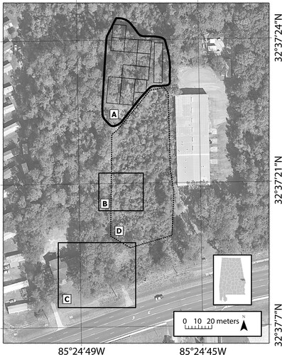
Figure 1. Map of the study area in Opelika, Alabama, with Lee County marked in the lower right. Survey area A with 10 grids outlined. Area B of the second cemetery site confirmed by two oral histories. C: Site of the previously existing house as well as gravesites confirmed by one informant and aerial photographs. D: Area that was clear cut in 2011. Aerial photograph accessed from Google Earth™ (Citation2021).
Geophysical techniques provide noninvasive, efficient techniques for surveying historic cemetery sites in that they do not require physical excavations and create minimal disturbance of the survey site. Examples of previously implemented methods include ground-penetrating radar (GPR), electrical resistivity, gradiometry, and microgravity surveys (Conyers Citation2006; Büyüksaraç et al. Citation2014; Moffat Citation2015; McKinnon and Haley Citation2017; Leach Citation2021). Electrical resistivity tomography (ERT) has been shown to provide excellent resolution in burial sites studies (e.g., Juerges et al. Citation2010; Nero et al. Citation2016). Increased resistivity values due to air-filled cavities or pore space are typically associated with disturbed soils or intact caskets relative to background resistivity values; however, in some instances, burials produced lower resistivity values attributed to increased conductivity resulting from fluids associated with decomposing bodies, particularly in naked burials (Juerges et al. Citation2010; Pringle and Jervis Citation2010). Although they offer high resolution, ERT surveys can be time-consuming because most systems use in-ground electrodes that are positioned individually by hand. In addition, tree roots and buried metal objects can create unwanted anomalies and artifacts, making data interpretation challenging. Gradiometry surveys have been used successfully at some archaeological sites (see examples from McKinnon and Haley Citation2017) but have had mixed success with burials and forensic investigations (e.g., Juerges et al. Citation2010). Because the GAGC was situated in a heavily forested area with remnants of discarded metallic material on the surface throughout the site, both magnetic methods and ERT were deemed unreliable. In addition, noise created by cultural interference is a common problem in interpreting magnetic anomalies, particularly in urban environments.
GPR provides efficient data collection in various terrains and site conditions and can detect soil disturbances, buried materials, and structures (Conyers Citation2006; Moffat Citation2015; Leach Citation2021). For these reasons, GPR was chosen as the preferred method for the GAGC site. It should be recognized, however, that GPR data collection and interpretation are dependent on environmental and cultural conditions that can be region-specific. For instance, site factors such as soil types (particularly the amount of clay) and water content can affect signal penetration. The signal can also differ depending on burial method, burial age, and climate; therefore, it is important to understand variations among different research environments for interpreting the acquired data (Fiedler et al. Citation2009; Conyers Citation2012). Multiple interment practices (e.g., both shroud and casket burials) exist in pre– and post–Civil War era African American cemeteries in the southeastern US, where high humidity and acidic soils are common and can significantly impact preservation.
Enslaved African American cemeteries often lack historical documentation related to site formation, which creates an opportunity for spatial data to contribute to analyses and site interpretations (Knitter and Nakoinz Citation2018). Tobler’s first law of geography states that variables close together are more likely to be related than distant variables (Tobler Citation1970). In a cemetery setting, this would suggest that adjacent graves might be more likely to share characteristics than distant graves. Similar characteristics, or trends, may relate to environmental factors, such as soil, slope, vegetation, and precipitation, or may relate to cemetery management and maintenance, where the amount of care and method of care may differ in different areas of the cemetery. Additionally, unique site disturbances, such as construction or clearcutting, may impact specific clusters of burials while leaving other, more distant burials undisturbed. While cultural and socioeconomic influences can produce outliers to the patterns suggested by Tobler’s law, such as family plots, they should not prevent us from applying spatial analyses to cemeteries. These outliers are still a part of the spatial pattern among graves and can provide important information about the cemetery’s social, cultural, and historical contexts.
Combining quantitative and qualitative methods, such as spatial analyses with archaeological data, has successfully improved interpretations of archaeological sites (Carrer Citation2015; Knitter and Nakoinz Citation2018). For example, analyses of megalith burial sites distribution have provided insight into regional cultural dynamics (Knitter and Nakoinz Citation2018). When performed on a smaller case scale, such as the GAGC, spatial analyses can potentially highlight statistically significant trends of potential burials to support interpretation and discussion about burial characteristics and cultural practices. Nobes (Citation1999) assigned qualitative values to GPR results to describe the confidence level of potential burial remains where survey conditions proved challenging. However, the values given were based primarily on reflection profiles with burial markers and did not provide a scale or methodology that could be easily translated to other locations for future researchers to use or expand upon. In other words, although this study provided quantitative results, it did not describe how the quantitative values were determined or the distribution of values throughout the site.
For those trying to preserve or study antebellum African American cemeteries like GAGC, remote sensing methods face several challenges and uncertainties resulting from physical limitations (e.g., vegetation, decay rates, soil conditions, and surface debris) and cultural practices (e.g., shroud versus casket burials). Our study seeks to address some of these challenges by offering an alternative methodology that combines GPR surveys, observational data, and spatial analyses to assist in identifying potential burials in this historically significant site.
Site description
The GAGC is situated on land adjacent to the gravesites that hosted homes for the Giddens family from 1901 to 2007. Although it is believed that there are three burial locations on the property, this study focused on Area A () because of outside interest in developing the area for commercial purposes and because it contained some marked burials. The boundaries of Area A were outlined by RPAAST based on geomorphologic features, which included streambeds to the south, a gully to the east, and property boundaries to the west. Only three individuals buried on the property are known by name: Viola Johnson, Cloriana Hardy, and Charlena Giddens Hall. While there are numerous stones present that are likely the head or foot stones of burials, only one headstone contains a name (Viola Johnson); it is believed, however, that this headstone had been moved from Area C to Area A (R. Bubb, personal communication, 2022). Some of the more intact and prominent field stones are spatially associated with two rows of linear depressions.
Previous archaeological and geoarchaeological research at cemeteries that pre- and post-date periods of enslavement in the Americas highlight some subsurface features that may also be present in the GAGC. First, individuals may have been interred with or without coffins. Individuals who could not afford burial in an established cemetery may also not have been able to afford coffins. Instead, burial in clothing or shrouds may have been common (e.g., Handler and Lange Citation1978; Howson Citation2006; Lee et al. Citation2009; Rainville Citation2014; Fleskes et al. Citation2021; Khan Citation2022). Second, burials from plantations and post-emancipation African American cemeteries frequently have an east-west orientation (e.g., Handler and Lange Citation1978; Pearson Citation1999; Perry et al. Citation2006; Brooks Citation2011; Honerkamp and Crook Citation2012; Rainville Citation2014; Bigman Citation2015). East-west orientation is common in some West African burial traditions (which may have been brought to North America with the slave trade) as well as in Christian burial traditions (Jamieson Citation1995; Honerkamp and Crook Citation2012).
Concrete slabs, barbed-wire fencing, buried metal cables, and other debris are found close to or within the study area, often near the locations where the houses used to be. The research site is overgrown with vegetation, containing trees, roots, stumps, logs, animal burrows, and vines, which impact survey collection and geophysical interpretation. Soils at the GAGC consist of Uchee loamy sand and Pacolet sandy loam, both of which contain high clay and sand contents and are acidic (Natural Resources Conservation Service Citation2019). High clay content leads to lower signal penetration for GPR; however, burials are typically shallow (< 2 meters). The soil types are well drained with a very low runoff class; water-table depth is estimated to be more than 2.0 meters. The soil maintains a high level of foliage cover throughout the year and contains a variety of vegetation. The study area has some slight elevation changes throughout, containing a 6–10% slope (Natural Resources Conservation Service Citation2019). A small dry stream channel is present in the southwest part of the study area and may have formed naturally or following a roadway that previously existed at the site.
Methodology
The GPR field survey used a GSSI SIR 4000 GPR unit with a 400-MHz antenna. The site (Area A) was divided into 10 grids and GPS coordinates were collected at the corners of each grid to allow for georeferencing during map creation (). The grids were roughly organized in 10-meter by 10-meter grids; however, this spacing could not be done uniformly throughout the site due to restrictions caused by the topography and other surface obstacles, such as gullies and trees. The data were collected unidirectionally at 0.25-meter intervals. Observational data were used to identify the location of trees, burial markers such as headstones and footstones, soil depressions, debris, and geomorphological features that could impact the grid design, data collection, and geophysical interpretations. The grids were cleared of excess vegetation with hand tools to allow for better instrument contact with the soil and to assist in identifying surface features such as burial markers or burial depressions. Data collection occurred during dry or average soil moisture conditions to improve GPR image resolution.
The software program RADAN 7™, version 7.0.4.9, was used to post-process the collected datasets and create reflection profiles and 3-D amplitude maps. The amplitude maps were then georeferenced to the site map using GPS coordinates in ArcGIS Pro™, version 2.8.3. Shapefiles containing 2-meter by 1-meter polygons were created to represent potential burial remains. In grids 4 and 5, smaller polygons were created based on the dimensions of existing headstones and footstones to represent the size and density of burials accurately.
Each polygon was assigned a qualitative value called “Burial Confidence” in the attribute table based on the cumulative sum of various features present at the burial location. This value represents the likelihood of that polygon containing a potential burial (). Burials ranged from a Burial Confidence value of 0–14, where values 1–4 are considered low-confidence burials, 4–7 are medium-confidence burials, 8–10 are high-confidence burials, and 11–14 are very high-confidence burials. Burial markers are defined as partially buried in the ground and generally rectangular. They may consist of either a headstone, a footstone, or both, and are given a high Burial Confidence value due to their likelihood of being related spatially to burials. Stones are also potential burial markers; however, they are often not buried firmly into the soil and do not contain a rectangular shape. These stones are less indicative of burials than more formal burial markers and are thus assigned a lower Burial Confidence value than the headstones and footstones. Surface depressions can be associated with burial locations because disturbed soils can later compact. These were assigned a moderate Burial Confidence value. Possible burial shafts, identified in reflection profiles, often indicate burials even after remains have decomposed; because they were uncommon on the site, burial shafts were given a low confidence rating. Hyperbolic reflections in GPR data, when they occur in particular patterns, can indicate caskets and burial remains. For instance, hyperbolic reflections are typically associated with signals reflecting off the corners of caskets. These hyperbolic reflections are assigned a medium Burial Confidence value. Burials often are situated in rows; for this study, a row consists of three or more potential burials within approximately two meters of one another. These potential burial remains appear as linear anomalies in the time-slice amplitude maps and are given additional value, as this geometric arrangement is not typically associated with roots or other sinuous anomalies ( and ). Lastly, orientation is considered, as African American cemeteries have been known to contain burials that are east-west facing (; Jamieson Citation1995).
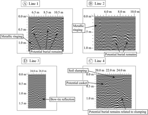
Figure 2. Depth slices showing high amplitude GPR signal returns (white bright spots) in grid 1 (see for reflection profile lines 1–4 and see for location). Burial features such as rows, linearity, east-west-facing orientation are observable in this grid. Areas A, B, C, D, and E included the presence of burial features and are believed to contain burials.
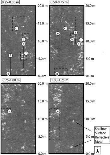
Figure 3. Corresponding reflection profiles from grid 1 showing potential burial remains.
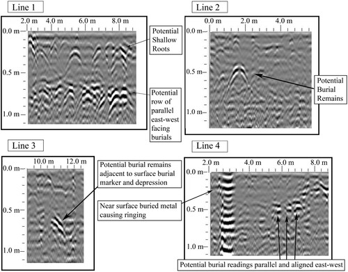
Table 1. Features considered for the Burial Confidence, which ranges from 0 to 14. Values added for each feature are listed as positive numbers next to the feature descriptions.
Results
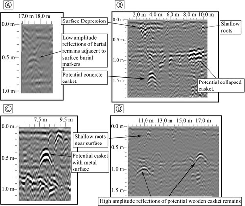
GPR reflection profiles indicated 129 potential burials: 34 low, 50 medium, 21 high, and 24 very high Burial Confidence values distributed in 14 rows containing at least three or more adjacent potential burials (). The burials associated with surface markers and burial depressions show GPR reflections interpreted as mostly deteriorated or collapsed wooden caskets, although a few anomalies had reversed polarity reflections, which may indicate void spaces from intact caskets (; Conyers Citation2012). In addition to wooden caskets, examples of potential concrete caskets and one possible metal casket were also located within the study area (). These burials are identifiable by hyperbolic reflections at a depth of approximately 0.50–1.50 meters, which is a common depth range for burials seen in similar studies (Conyers Citation2012). Discontinuous reflections are observed at 0.75 m in most profiles. These discontinuous reflections may be linked to discontinuous or interbedded clays or clayey soils. Visual reconnaissance identified 62 burial markers, correlating to 41 burials, and 48 surface depressions. Most potential burials with high-condition values are located within grids 4, 5, 6, and 7, with the lowest values in grids 2 and 3 ().
Figure 4. Map of the surveyed area displaying the 10 marked grids containing 129 potential burials color coded by confidence value. These condition values represent the likelihood of being a burial and range from low (2) to high (14). Aerial photograph accessed from Google Earth™ (Citation2021).
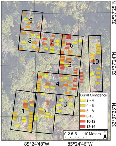
Figure 5. Reflection profiles of diverse casket burial remains. A: Low amplitude reflections suggest a potential shroud burial or highly deteriorated wooden casket. B: High amplitude reflection of a potential concrete casket and a potential collapsed casket. C: Very high amplitude reflection of a casket likely with a metal lid. D: Reflections of potential wooden caskets.
Discussion
Potential burial remains are primarily identified in GPR data by hyperbolic curves, which are typical in most cemetery sites (; Conyers Citation2006; Nobes Citation1999). West-east linear lines in the amplitude maps () were located throughout the study area, which is characteristic of burial orientations of Christian and African American cemeteries (Handler and Lange Citation1978; Pearson Citation1999; Perry et al. Citation2006; Rainville Citation2014). Hyperbolic reflections that were consistently observed on adjacent lines within the grids and that formed linear patterns in amplitude maps were determined to be burial related. Long sinuous patterns were attributed to roots. Nearby tree locations were noted when determining the potential for hyperbolic reflections to be associated with burials instead of roots.
Many grids contained discontinuous reflections at approximately 0.75 m depth. These reflections may indicate discontinuous or interbedded clay layers or lenses. These reflections often occurred beneath burial markers, surface depressions, and possible burial shafts, which indicate they were likely related to burial remains. Ringing in the GPR data was sometimes associated with these reflections, a feature commonly associated with metals. It is possible that the burials were placed on top of the clay layer, as digging would have become more difficult.
Bow-tie and X-shaped reflections seen on the GPR profiles are associated with some burials within the study site (). These reflection styles result from square and V- or U-shaped trenching, possibly associated with burial shafts (Goodman and Piro Citation2013). The reason behind the presence or absence of burial shafts and trenches in the cemetery remains unknown. One possibility is that the soil within the trench closely resembles the surrounding host sediment, leading to a weak reflection that may not be easily detectable. Another possibility is that the dense low-lying vegetation and vine growth throughout the site prior to the survey may have disrupted the burial shaft structure.
Figure 6. Bow-tie reflection found within grid 10 indicating potential trenching.
The polarity of some reflection profile hyperbola suggests that most caskets contained no void space and had collapsed (see B). A few reflections showed reversed polarity of black-white-black patterns, potentially indicating void space with a casket still intact (see D). This observation is consistent with the notion that humid environments break down and decompose burial remains, potentially making interpretations of GPR data more difficult in humid climates (Conyers Citation2012). However, intact coffins indicate that some burial features will likely remain even in humid climates or that these may be more recent burials.
Potential metal and concrete caskets were located in grid 4. These caskets produced high-amplitude hyperbolic signals, possibly from metal framework within the concrete, and occurred at greater depths than other burials (see B and C; Byer and Mundell Citation2003). These anomalies could indicate that many of the burials within grid 4 occurred postbellum, as metal and concrete are more costly and formal than wooden caskets. It is unknown when burials first began in the GAGC; however, it is known that burials continued until approximately the 1930s for those who could not afford the more established cemetery at Rosemere (R. Bubb, personal communication, 2021). Those who were buried in the metal or concrete caskets may have had the means to afford other burial arrangements, but chose the GAGC for other reasons, such as being close to family members. Grid 4 contained a clustering of burials with high-condition values, and, combined with the unique burial arrangement, suggests that this grid may contain the most recent burials within the cemetery. The proximity of potential burials with similar confidence values supports Tobler’s law that neighboring burials are likely to be related in age, burial methods, and preservation condition.
Based on the results of GPR and visual inspection, the grids 4–7 exhibit high confidence values, which could indicate several possibilities: (1) slower decomposition rates, (2) relatively recent burials, or (3) a distinctive regional history that contributed to the preservation of burials. For example, grid 4 shows reflection profiles that suggest the presence of concrete and metal caskets. On the other hand, grids 1, 2, 8, and 10 have lower burial confidence values and, in some instances, exhibit lower amplitude readings, as well as a lack of burial markers and surface depressions. These lower amplitude readings may indicate high rates of decomposition, more homogeneous soil compositions, older burials, or a unique regional history in which surface features have been removed. In addition to the low-amplitude readings, some high-value burials contained no notable GPR reflections in profiles, despite ample evidence on the surface. These instances suggest that multiple approaches are needed to evaluate the presence of potential graves.
Creating the Burial Confidence grading scale was helpful for interpreting the GPR and spatial data. The assigned values created a clear means for displaying and discussing GPR datasets and the condition and confidence in the potential burials located. It allowed for additional interpretation and analysis of regional trends and cultural behaviors. Additionally, it served as a means of discussing relative decay states and burial ages.
The values on the confidence scale could be adjusted based on study sites or available data. Currently, high value is placed on the surface features such as burial markers and depressions, as it was uncertain whether the GPR could accurately locate burials in humid climates and clay-rich soils. Results from this study demonstrate that GPR can effectively locate burial remains and therefore, it may be helpful to grant higher value to the reflection profiles. Additionally, reflection profiles could provide a quantitative range by themselves (Nobes Citation1999), as some of the reflection profile signals indicate the presence of caskets while other reflections are more open to interpretation.
Awareness of the potential for the confidence value to be in error is important. Naturally occurring depressions and stones could have been incorrectly assigned a high confidence value by the scoring system used in this study. Some surface depressions are naturally formed by vegetation and animal burrows, and some remains may have been buried in orientations other than east-west due to cultural practices or burial space restrictions. Although some observed features may be misinterpreted, the cumulative value of burial features could reduce the influence of outliers or natural features that resemble burial features.
Conclusion
The GPR data together with surface reconnaissance and spatial analysis were able to identify approximately 129 potential burials: 34 low, 50 medium, 21 high, and 24 very high confidence burials. The shallow depth and deteriorated condition of many burials highlight the importance of preserving and protecting the historic cemeteries against further erosion and disruption. These results were able to provide RPAAST with valuable information about the extent of unmarked burials and their approximate locations within the surveyed area so that they can be preserved from commercial development. Unfortunately, shortly after completing the GPR survey over Area A of the GAGC, portions B and C of the cemetery were damaged or destroyed as development proceeded. Trees were uprooted and earth moved, potentially disturbing burials on the property. Land modification stopped at the southern edge of the GPR survey, but we may never know how much farther the main burial grounds extended beyond. Following that damage, the landowners, Lee County Cemetery Preservation Committee, and RPAAST entered into an agreement to protect and improve the integrity of the three burial sites at GAGC. This agreement includes future GPR surveys performed before any land modifications, no encroachment within 10 feet of any confirmed or agreed-upon burial sites, and the creation of an enclosed memorial space near Area C of the cemetery. The enclosed memorial space was completed in spring 2023. Possible field stone/headstones were left in situ and marked with open wooden boxes; the rest of the memorial space was sodded and enclosed with a wooden fence. RPAAST (along with volunteer help) continues to regularly visit the GAGC in order to maintain the memorial space and clean debris and overgrowth from Area A.
GPR can be an efficient method for surveying antebellum African American cemeteries within humid environmental site conditions within limitations. GPR alone is not able to provide consistent and clear results by itself and is best applied by integrating other technologies and approaches. Some clearly marked burials, containing both burial markers and surface depressions, failed to produce noticeable anomalies within the reflection profiles. This result suggests the site contains high rates of burial deterioration and site alteration, which can prevent clear results and interpretations. However, some potential caskets still appeared to contain void space, indicating minimal decomposition. This mixed success rate indicates that using GPR in humid environments may be complicated and further research into understanding burial decay factors and rates may be necessary.
Applying additional geophysical techniques such as electrical resistivity and gradiometry, when possible, would allow for more accurate interpretations of the material left behind by decayed burial remains and to distinguish potential stratigraphic layers in the soil. Minimally invasive techniques, such as collecting soil cores nearby, may provide helpful information for geophysical interpretations while still maintaining a culturally respectful survey.
Creating a qualitative value system to determine the condition of potential burials helped to assess spatial trends of the collected GPR data. Previous GPR surveys have been incapable of determining the state of decay of specific burials (Fiedler et al. Citation2009). The quantitative value system developed in this study addresses this issue by enabling the comparison of burial confidence and burial distribution within the cemetery. This comparison allows for greater confidence in interpreting decay rate, potential burial age, and potential regional site histories. Burials often reflected similar values within close proximity to one another. This relationship supports Tobler’s first law and indicates that the neighboring burials are likely to be related in age, burial methods, and preservation condition. This result supports that assertion that the application of spatial analysis to cemetery sites will improve interpretations and highlight statistically significant spatial trends. If additional study sites apply similar methods to collect and share the spatial distribution and condition of burials, future researchers may be able to piece together a narrative about decay rates based on age and site conditions. In addition, similar quantitative value systems and spatial analyses would likely be helpful in other studies that utilize GPR data, where detailed information may be lacking and interpretations need additional support.
Acknowledgments
The authors would like to thank Robert Bubb, PhD, from the Auburn University Department of Human Development and Family Studies for facilitating access to the research site and providing invaluable information about the Giddens family. We also would like to acknowledge the Research to Preserve African American Stories and Traditions (RPAAST) and the Lee County Cemetery Preservation Commission for their ongoing work to preserve and protect cemeteries. Finally we appreciate Dr. Peter Leach of Geophysical Survey Systems, Inc., for sharing his expertise in archaeological applications of GPR.
Disclosure statement
No potential conflict of interest was reported by the author(s).
Data availability statement
The GPR data files are preserved on Auburn University servers. These files will be shared on a case-by-case basis by request. Contact the corresponding author.
Additional information
Notes on contributors
Hayden Malloch
Hayden Malloch is a staff geoscientist with Thomas Harder & Company. He conducted this work as a part of his masters of science in geology in the Department of Geosciences at Auburn University.
Stephanie L. Shepherd
Stephanie L. Shepherd is an associate professor of geomorphology in the Department of Geosciences at Auburn University. In addition to her research in fluvial geomorphology, specifically how heterogeneous lithology controls fluvial form and process, she applies geomorphic and geophysical methods to study and preserve African American cemeteries.
Lorraine Wolf
Lorraine Wolf is a Lawrence C. Wit Endowed Emerita Professor of Geophysics in the Department of Geosciences at Auburn University. Her research focused on earthquake hazards and applications of near-surface geophysical methods to environmental and engineering problems.
Meghan Buchanan
Meghan Buchanan is an associate professor of anthropology in the Department of Sociology, Anthropology, and Social Work at Auburn University. Her research interests include Mississippian societies, conflict and warfare, sociopolitical collapse and resilience, and collections management and curation.
References
- Alabama Historical Commission 2022 George and Addie Giddens Cemetery. Alabama Historic Cemetery Register. https://ahc.alabama.gov/cemeteryprogram.aspx, accessed April 14, 2023.
- Bigman, Daniel P. 2013 Mapping Social Relationships: Geophysical Survey of a Nineteenth-Century American Slave Cemetery. Archaeological and Anthropological Sciences 6:17–30. doi:10.1007/s12520-013-0119-6.
- Bigman, Daniel P. 2015 Ground Penetrating Radar Survey of the Nathan Anderson Cemetery, Ringgold, GA. Report prepared for Nathan Anderson Cemetery. https://www.nathanandersoncemetery.org/Page6.pdf.
- Brooks, Christina 2011 Enclosing Their Immortal Souls: A Survey of Two African American Cemeteries in Georgetown, South Carolina. Southeastern Archaeology 30:176–186.
- Buchanan, Meghan, Alexandra Jones, and Maureen Meyers 2022 SEAC and Archaeology in the Community Partnership. Horizon and Tradition 64(2):24.
- Büyüksaraç, Aydın, Cahit Çağlar Yalçıner, Yunus Levent Ekinci, Alper Demirci, and Mehmet Ali Yücel 2014 Geophysical Investigations at Agadere Cemetery, Gallipoli Peninsular, NW Turkey. Australian Journal of Forensic Sciences 46:111–123. doi:10.1080/00450618.2013.804948.
- Byer, Gregory B., and John A. Mundell 2003 Use of Precision Mapping and Multiple Geophysical Methods at the Historic Reese Cemetery in Muncie, Indiana. In Symposium on the Application of Geophysics to Engineering and Environmental Problems Proceedings, pp. 68–79. Environmental & Engineering Geophysical Society, San Antonio, Texas. doi:10.4133/1.2923215.
- Carrer, Francesco 2015 Interpreting Intra-site Spatial Patterns in Seasonal Contexts: An Ethnoarchaeological Case Study from the Western Alps. Journal of Archaeological Method and Theory 24:303–327. doi:10.1007/s10816-015-9268-5.
- Conyers, Lawerence B. 2006 Ground-Penetrating Radar Techniques to Discover and Map Historic Graves. Historical Archaeology 40:64–73. doi:10.1007/BF03376733.
- Conyers, Lawerence B. 2012 Interpreting Ground-Penetrating Radar for Archaeology. Left Coast Press, Walnut Creek, California.
- Dunnavant, Justin, Delande Justinvil, and Chip Colwell 2021 Craft an African American Graves Protection and Repatriation Act. Nature 593(7859):337–340.
- Fiedler, Sabine, Bernhard Illich, Jochen Berger, and Matthias Graw 2009 The Effectiveness of Ground-Penetrating Radar Surveys in the Location of Unmarked Burial Sites in Modern Cemeteries. Journal of Applied Geophysics 68:380–385. doi:10.1016/j.jappgeo.2009.03.003.
- Fleskes, Raquel E., Ade A. Ofunniyin, Joanna K. Gilmore, Eric Poplin, Suzanne M. Abel, Wolf D. Bueschgen, Chelsey Juarez, Nic Butler, Grant Mishoe, La’Sheia Oubré, Graciela S. Cabana, and Theodore G. Schurr 2021 Ancestry, Health, and Lived Experiences of Enslaved Africans in 18th Century Charleston: An Osteobiographical Analysis. American Journal of Physical Anthropology 175:3–24. doi:10.1002/ajpa.24149.
- Goodman, D., and S. Piro 2013 GPR Remote Sensing in Archaeology. Springer, Berlin.
- Google Earth™ 2021 www.earthgoogle.com. Image date October 19, 2016. Accessed October 9, 2021.
- Graham, Lain, Jeffery Glover, Andrew Vaughan, and Daniel Bigman 2014 Flat Rock Community Mapping Project: Geophysical Survey of an Historic African American Cemetery. In Symposium on the Application of Geophysics to Engineering and Environmental Problems 2014, pp. 58–58. Environmental & Engineering Geophysical Society, Boston, MA. doi:10.4133/sageep.27-028.
- Handler, Jerome S., and Fredrick W. Lange 1978 Plantation Slavery in Barbados; An Archaeological and Historical Investigation. Harvard University Press, Cambridge, MA.
- Honerkamp, Nicholas, and Ray Crook 2012 Archaeology in a Geechee Graveyard. Southeastern Archaeology 31:103–114. doi:10.1179/sea.2012.31.1.007.
- Howson, Jean 2006 Pins and Shrouds. In New York African Burial Ground Archaeology Final Report; Volume 1, edited by Warren E. Perry, Jean Howson, Barbara A. Bianco, pp. 288–305. Report to the US General Services Administration, Northeastern and Caribbean Region.
- Jamieson, Ross W. 1995 Material Culture and Social Death: African-American Burial Practices. Historical Archaeology 29(4):39–58. doi:10.1007/BF03374216.
- Jones, Alexandra, Maureen Meyers, and Meghan Buchanan 2023 Partnership between the Southeastern Archaeological Conference and Archaeology in the Community. SAA Archaeological Record 23(2):9–11.
- Juerges, A., Jamie K. Pringle, John R. Jervis, and P. Masters 2010 Comparisons of Magnetic and Electrical Resistivity Surveys Over Clandestine Graves in Contrasting Burial Environments. Near Surface Geophysics 8:529–539.
- Khan, Ayesha Rabiya 2022 Finding Lost Voices: An Archaeological Study of Historic, African American Burial Sites. MA thesis, Department of Anthropology, Georgia State University, Atlanta, Georgia. https://doi.org/10.57709/27385440.
- Knitter, D., and O. Nakoinz 2018 Point Pattern Analysis as Tool for Digital Geoarchaeology: A Case Study of Megalithic Graves in Schleswig-Holstein, Germany. In Digital Geoarchaeology, edited by Christoph Siart, Markus Forbriger, and Olaf Bubenzer, pp. 45–64. Springer, Cham.
- Leach, Peter A. 2021 A Theory Primer and Field Guide for Archaeological, Cemetery, and Forensic Surveys with Ground Penetrating Radar. Geophysical Survey Systems Inc., Nashua, New Hampshire.
- Lee, Esther J., Lisa M. Anderson, Vanessa Dale, and D. Andrew Meriwether 2009 MtDNA Origins of an Enslaved Labor Force from the 18th Century Schuyler Flatts Burial Ground in Colonial Albany, NY: Africans, Native Americans, and Malagasy?. Journal of Archaeological Science 36:2805–2810. doi:10.1016/j.jas.2009.09.008.
- McKinnon, Duncan P., and Brian S. Haley (editors) 2017 Archeological Remote Sensing in North America: Innovative Techniques for Anthropological Applications. University of Alabama Press, Tuscaloosa.
- Moffat, Ian 2015 Locating Graves with Geophysics. In Best Practices of GeoInformatic Technologies for the Mapping of Archaeolandscapes, edited by Apostolos Sarris, pp. 45–53. Archeopress Publishing, Oxford, England.
- Natural Resources Conservation Service 2019 Web Soil Survey. http://websoilsurvey.sc.egov.usda.gov/, accessed February 6, 2021.
- Nero, Callistus, Akwasi Acheampong Aning, Sylvester K. Danour, and Reginald M. Noye 2016 Delineation of Graves Using Electrical Resistivity Tomography. Journal of Applied Geophysics 126:138–147. doi:10.1016/j.jappgeo.2016.01.012.
- Nobes, David C. 1999 Geophysical Surveys of Burial Sites: A Case Study of the Oaro Urupa. Geophysics 64:357–367. doi:10.1190/1.1444540.
- Pearson, Michael Parker 1999 The Archaeology of Death and Burial. Texas A&M University Press, College Station, TX.
- Perry, Warren R., Jean Howson, and Barbara A. Bianco (editors) 2006 New York African Burial Ground Archaeology Final Report, Volume 1. Prepared for the United States General Services Administration Northeastern and Caribbean Region. Howard University, Washington, DC.
- Pringle, Jamie K., and John R. Jervis 2010 Electrical Resistivity Survey to Search for a Recent Clandestine Burial of a Homicide Victim, UK. Forensic Science International 202:e1–e7. doi:10.1016/j.forsciint.2010.04.023.
- Proulx, Michelle, and R. Shane McGary 2019 Reclaiming History: Using Ground Penetrating Radar to Identify the Location of Antebellum African American Cemeteries. Paper presented at the SEG International Exposition and Annual Meeting, San Antonio, Texas. doi:10.1190/segam2019-3216782.1.
- Rainville, Lynn 2014 Hidden History: African American Cemeteries in Central Virginia. University of Virginia Press, Charlottesville.
- Tobler, Waldo R. 1970 A Computer Movie Simulating Urban Growth in the Detroit Region. Economic Geography 46:234–240. doi:10.2307/143141.