
ABSTRACT
Walkability is generally defined by the extent to which the built environment supports and encourages walking by promoting pedestrian comfort, connectivity and convenience. This paper scrutinizes the steps taken in Johannesburg to develop walkability policies and projects. It draws on empirical evidence from the pedestrian policies (e.g., the Corridors of Freedom) and pedestrian projects (e.g., the Grayston Pedestrian Bridge) recently introduced. Rather than focusing on the merits of walkability or the ease of its application, this paper highlights the misunderstandings of introducing walkability in Johannesburg. The concept is particularly problematic in Johannesburg, where the “unpleasantness of walking” and “walkability-with-people” is insufficiently considered. In a broader sense, this discussion aims to first understand urban planning in an African/Global South city, and then to decolonize transport planning by bringing the experiences in Johannesburg to the forefront. Such a critical reading of the intertwined and overlapping practices of policymaking provides additional insights into the processes of urban planning and transport in Johannesburg and beyond.
Introduction
For Walter Benjamin, the flâneur was an affluent resident of 19th century Paris who aimlessly strolled the city for entertainment (Lauster, Citation2007). Such a romantic image stands in sharp contrast to the contemporary pedestrian scurrying across six lanes of fast-moving traffic to get to their low-paying job, or the seller trudging along the unpaved, unimproved verge taking their wares to the market. The purpose of this paper is to engage with the concept of walkability, which is generally defined by the degree to which the built environment supports and encourages walking by providing pedestrian comfort, connectivity and convenience (Southworth, Citation2005). It draws on empirical evidence from the pedestrian policies and projects recently introduced in South Africa. Specifically, it asks how the concept of walkability has been applied in Johannesburg; and how Johannesburg’s application expands our understanding of walkability? It is not a straightforward case accounted for by policymaking, however. Rather than demonstrating the merits of walkability or the ease of its application, this paper highlights the challenges of actually doing walkability.
This analysis of walkability is particularly relevant in African cities, where pedestrian rates are higher than in their American or European counterparts. On average, across African cities 50% of trips are made on foot—with as many as 81% in Dakar or 70% of trips in Kinshasa and Addis Ababa, and as few as 42% in Ouagadougou (Pendakur, Citation2005). A 2010 survey of mobility in Niamey, Niger confirms a similar predilection for walking with 53% of trips made on foot (Olvera et al., Citation2010). Walking, for many Africans, is their only means of mobility. Rapid urbanization, urban sprawl, and the ambiguous role of government as both a transport policymaker and policy regulator, further exacerbates already limited mobility choices (Pirie, Citation2014).
Walking is especially noteworthy in Johannesburg: of the 3.5 million daily trips, 800,000 trips are made by walking (“all the way”; City of Johannesburg, Citation2013b). These “captive walkers” are pedestrians because they have no alternative (Montgomery & Roberts, Citation2008). Data reveals that in Johannesburg 66% of households do not own a car (City of Johannesburg, Citation2009); and therefore 60% of households spend more than 10% of their income on motorized forms of public transport, up from 55% in 2014 (Gauteng Department of Roads and Transport, Citation2020). These captive walkers are also “time poor” with the average pedestrian exerting significantly more time and energy on mobility (Montgomery & Roberts, Citation2008). Over the past five years, walking time to the first public transport stop has increased from 9 to 14 minutes, while access to the final destination has increased from 8 to 14 minutes (Gauteng Department of Roads and Transport, Citation2020). Moreover, pedestrians account for 40% of all road fatalities (Road Traffic Management Corporation, Citation2018). Such data triggers renewed attention to walking and walking infrastructure.
Within urban studies, this paper adds to the ongoing reconceptualization of urban mobilities in the Global South (Uteng & Lucas, Citation2017), as well as transport planning (Appelhans et al., Citation2021) and non-motorized transport in African cities (Mitullah et al., Citation2017). Indeed, this is not the first attempt to feature walking in studies of African cities—studies of Praia, Cabo Verde (Anciaes et al., Citation2017) and Nairobi, Kenya (Nyamai, Citation2021) serve as pertinent antecedents. Likewise, a host of international (Montgomery & Roberts, Citation2008; Pendakur, Citation2005) and South African research reports (Harber et al., Citation2018; Pieterse & Owens, Citation2018) highlight the important role walking plays in urban development. However, further analysis is warranted. By drawing on policies and projects in Johannesburg, this paper contributes to both empirical surveys of walking in African cities (Behrens, Citation2005) and theoretically-rich discussions of walkability (Zavetoski & Agyeman, Citation2015).
Second, this paper adds to burgeoning calls to decolonize transport planning (Wood et al., Citation2020). Decolonizing is a concept with many meanings and uses depending on the disciplinary background and geographical context. For Fanon (Citation1961, p. 36), decolonizing “sets out to change the order of the world”; and long-standing critiques by Said (Citation1978) and Spivak (Citation1988) have renewed attention in support of knowledge production in Africa (Craggs & Neate, Citation2019). Advocates of decolonizing transport planning argue against the continued dominance of northern models and metrics, and instead highlight best practices in the Global South (Wood et al., Citation2020). Decentering the dominance of northern-based motorized transport-based research and instead focusing on more egalitarian modalities such as walking, is one method for decolonizing transport. Indeed, transport scholars have begun to engage with these strategies—for instance, in a special issue featuring urban mobilities in the Global South (Priya Uteng & Lucas, Citation2018)—but much more needs to be said about transport planning from the Global South.
Methodologically, this paper analyzes the practice by which city officials introduce walkability into transport policies and planning. It is the outcome of recurring engagement with urban policy actors inside and outside government. Between 2012 and 2020, interviews were conducted with architects, consultants, politicians, and planners involved with walkability in South Africa as well as international transport experts. I also reviewed the relevant frameworks (e.g., City of Johannesburg, Citation2009), legislation (e.g., National Land Transport Act, Parliament, Citation2009) and international guides (e.g., Fang, Citation2013). The archive of the Johannesburg Development Agency (JDA), a parastatal organization responsible for implementing capital investments such as the Grayston Pedestrian Bridge, also provided essential primary data for this paper (e.g., JDA, Citation2015a, Citation2018b).
The next section details the background of the association between urban development and walkability. From there, the paper considers how walkability has been conceptualized across a range of urban literatures. The following section then turns to the empirical discussion of planning for walkability in Johannesburg by considering the pedestrian policies (e.g., the Corridors of Freedom) and pedestrian projects (e.g., the Grayston Pedestrian Bridge) recently introduced. The final empirical discussion focuses on the misunderstandings and complications around walkability in Johannesburg, citing evidence of the “unpleasantness of walking” and “walkability-with-people” from the Grayston Pedestrian Bridge, the Westbury Pedestrian Bridge and the Milpark Pedestrian Bridge. These examples provide valuable insight into South African understandings of urban walkability. In concluding, I reflect on the main theoretical arguments that serve to problematize the concept of walkability.
Urban development and walkability
Walkability is not a new feature of cities. In the Middle Ages, cities were by necessity walkable with an average spread of just a half-mile; and cities remained walkable through the industrial era. Urbino, Italy for instance, accommodated 30,000 people within an area of 300 acres warranting a density of dwellings and diversity of overlapping activities; meanwhile until the 19th century every point in Boston, Massachusetts, was less than one mile apart (Southworth, Citation2005). The introduction of transport services—the horse-drawn cart, the horse-drawn tram, the electric tram and the automobile—fueled the dispersal of urban life and the accompanying decline in walkability (Alca˘ntara De Vasconcellos, Citation2004).
In the postwar period, in response to the proliferation of car dependency and suburban growth, scholarship began to question the relationship between car-usage and land use. Authors advocated for a limiting of vehicle growth as well as infrastructure and amenities to support walking, cycling and public transport (Khayesi et al., Citation2010). Scholars in this era, much like today, were particularly inspired by Jane Jacobs (Citation1961), the New York-based urban activist, whose observations of urbanism remain the cornerstone for walkability (Dovey & Pafka, Citation2020). Buchanan (Citation1963, p. 40) for instance, recognized the inherent conflict between traffic and the environment as well as the “accessibility problem”; and Whol and Martin (Citation1967) expose the economic and social inadequacies of the then-current transport research. Appleyard (Citation1981) added his research on “livable streets,” a term he introduced to address both the macro and micro characteristics of the roadway. In his study of street morphology in San Francisco, Appleyard demonstrated a link between traffic volume and sociality concluding that residents of streets with low traffic volumes had three times more friends than those living on streets with high volumes. This understanding of “the street as a sanctuary” (Alca˘ntara De Vasconcellos, Citation2004, p. 8), what Appleyard called the “ecology of the street,” emphasized the relationship between mobility and livability or the driver and the resident. These historical discussions continue to inform ongoing walkability research and practice.
Contemporary associations between urban development and walkability use a range of terminology: “universal design,” a term used for a dropped curb on an accessible sidewalk (Goldsmith, Citation1963); “road diets,” when a four-lane road is converted to three (Labuschagne & Ribbens, Citation2014); and “complete streets,” a term coined in 2003 by Barbara McCann and the American advocacy organization America Bikes to incorporate crosswalks, sidewalks, bicycle lanes and road medians into mainstream transport infrastructure. As opposed to “routine accommodation,” the lexicon previously used to for bicycle-based transport planning (Zavetoski & Agyeman, Citation2015), a complete street includes cyclists, pedestrians, motorists and “transit riders of all ages and abilities” in transport planning ensuring that they are “able to safely move along and across a complete street” (McCann & Rynne, Citation2017, p. 3). A complete streets policy then considers the whole right-of-way—e.g., sidewalks, crossings, cycle lanes and road medians—in the design, planning, operations and maintenance of the road. The concept was picked up in the United States by the American Planning Association and American Association of Retired Persons, as well as by international advocates including the Bicycle Empowerment Network based in Cape Town and Embarq in Mexico City (Prytherch, Citation2018). Such terminology according to Zavetoski and Agyeman (Citation2015) denotes a form of “street-level spatial justice,” a “democratization of the street” by decentering drivers and redistributing the right of the right-of-way to the public; and Litman (Citation2015, p. 14) suggests that complete streets policies “help achieve equity objectives by giving non-drivers a fair share of road space.” The concept of complete streets is not without criticism, however: Zavetoski and Agyeman (Citation2015), for instance, propose that such language dehumanizes road users and presumes an unjust rationality to modal choice. Moreover it presumes streets exist in the abstract by isolating the designated area from the other parts of the city.
A number of organizations have attempted to codify a set of metrics for assessing walkability: as early as 1997, the U.S. Department of Transportation developed a walkability checklist to allow parents and children to characterize the walkability of their neighborhood (U.S. Department of Transportation, Citation1997). In 2006, Krambeck (Citation2006) proposed a qualitative analysis of walking conditions called the Global Walkability Index that included a public survey. In 2008, the World Bank proposed another five dimensions—accessibility/mobility (i.e., the distance and duration of the average walking trip), safety (i.e., the rate of pedestrian fatalities per population), security (i.e., the rate of pedestrian-targeted crime), legality (i.e., pedestrian laws and rights) and public expenditure (i.e., percent of total urban infrastructure and maintenance funds spent on pedestrian facilities)—to measure the pedestrian environment in cities of the Global South (Montgomery & Roberts, Citation2008). In 2018, the Institute for Transportation and Development Policy (ITDP), a New York–based sustainable transport advocacy organization introduced “Pedestrians First: A Tool for Walkable Cities,” another tool to enable cities to measure the features that promote walking. This set of 11 indicators considers walkways, crosswalks, visual frontage, physical frontage, shade and connectivity as essential characteristics of walkability (ITDP, Citation2018). These attempts to assess the walkability of an urban area and its associated infrastructure are flawed because these metrics are generally cumbersome to measure. Likewise, where it is possible to measure the walkability of a neighborhood, it is more complicated on a city-scale. Moreover, these indices fail to adequately consider why people walk, focusing too heavily on the characteristics of the pedestrian environment. A clearer conceptualization of walkability is needed to provide the theoretical scaffolding for the remainder of this study.
Conceptualizing walkability
Walkability is a central characteristic of urban space with an equivocal definition (Dovey & Pafka, Citation2020; Forsyth, Citation2015). Scholars across a range of disciplines have attempted to define walkability—in health studies, walkability is attributed to the physical attributes of the local environment (Leslie et al., Citation2005; Rigolon et al., Citation2018); in transport studies, walkability is correlated with household travel behavior (Manaugh & El-Geneidy, Citation2011); and in urban studies, walkability sits at the intersection between economic and social development and urban design (Dovey & Pafka, Citation2020). This paper assumes a multidisciplinary approach, defining walkability as “the extent to which the built environment supports and encourages walking by providing for pedestrian comfort and safety, connecting people with varied destinations within a reasonable amount of time and effort, and offering visual interest in journeys throughout the network” (Southworth, Citation2005, p. 248). In discussing the various characteristics of walkability, the paper advocates for greater attention to two often overlooked areas: “the unpleasantness of walking” and “walkability-with-people.”
The physical characteristics of the urban environment at both the microscale (e.g., sidewalks and crosswalks) and the macroscale (e.g., residential density, variety of business), influence the behaviors of pedestrians (Rigolon et al., Citation2018). The quality of pedestrian facilities, roadway conditions, land use patterns, and security provisions are important components of walkability (Ewing & Cervero, Citation2010; Litman, Citation2003). Walkable areas are “close,” (i.e., a short distance between origin and destination), “barrier-free,” (i.e., accessible for all bodies), “safe,” (i.e., void of crime and cars), “full of pedestrian infrastructure and destinations,” (i.e., sidewalks, raised pedestrian crossings, street furniture, trees), and oftentimes “upscale, leafy, or cosmopolitan” (i.e., “pleasant for middle-class professionals who have other choices for getting around”; Forsyth & Southworth, Citation2008, p. 2). Also importantly, the extent to which the walkable paths are connected (i.e., comprehensive network of pathways), convenient (i.e., direct routes without lengthy diversions), comfortable (i.e., no steep gradients, good weather, good lighting, feeling safe), convivial (i.e., the presence of landscaping and street furnishings), and conspicuous (i.e., legible routes with clear signage, integration with public transport) are some of the physical factors of walkability (Pharoah & Buchan, Citation1997).
In addition to these features, walkability is also used as a planning instrument to promote principles of inclusivity (e.g., the association between walkability and equity), livability (e.g., the association between walkability and the local environment), and sustainability (e.g., the association between walkability and land use; Litman, Citation2003). For Litman (Citation2003), walkability has far-reaching economic, social, and environmental benefits through increasing employment, generating tax revenue, raising property values, decreasing transport costs, and reducing the amount of land used for roads, and parking. Planning for walkability therefore requires an alignment between “residents’ desires and expectations for types of destinations, their willingness to walk a given distance and the quality of the required path” (Manaugh & El-Geneidy, Citation2011). Given this extensive list of benefits, furthering walkability is just good transport planning sense.
While scholarship on walkability remains interdisciplinary, encompassing discussions in urban planning, transport, urban design as well as geography, it is important to note that much of the existing literature and best practice is situated in North America even as the concept has increasing international relevance (Guerra et al., Citation2017; McCann & Rynne, Citation2017). The abovementioned definitions of walkability are generally drawn from examples in the Global North, and these classifications and conceptualizations are not always relevant in the Global South. In these northern contexts, transport research generally attempts to develop indices and metrics with only limited attention toward policymaking and community-building (Chen, Citation2019; Guerra et al., Citation2017). By contrast, this study is not only located outside of the Global North, but also draws on a decolonial approach to transport planning. Indeed, by considering how Johannesburg planners are encouraging walkability, as well as the difficulties of actually doing walkability, this paper problematizes the overarching discourses around walkability in an African context.
Beyond the tangible and intangible elements of walkability, there is a need to rethink two additional areas often discounted in the literature: “the unpleasantness of walking” and “walkability-with-people.” For the most part, the literature promotes the economic and social benefits of walking (Litman, Citation2003), with insufficient reflection on disagreeableness of walking (Ewing & Cervero, Citation2010), what I call “the unpleasantness of walking.” Likewise much of the existing discussion considers the role of planners, rather than communities, in furthering walkability (Manaugh & El-Geneidy, Citation2011), forgetting what I call “walkability-with-people.” These are particularly important additions to the discussion because they enable us to follow an egalitarian perspective on transport, which reasons that transport has a social benefit for all users (and would-be users) and therefore investment should be made to increase access for the maximum number (Van Wee & Geurs, Citation2011).
In her review of walkability, Forsyth (Citation2015) introduces some of these broader concerns for the unpleasantness of walking. She categorizes the literature into considerations for how to create walkability, how to assess walkability and “walkability as a proxy for better design.” Within the first category, Forsyth delineates between walkability as a synonym for “traversable” (e.g., the urban conditions that facilitate movement) and “compact” (e.g., short distances between destinations), “safe” (e.g., perceived to be without crime) and “physically enticing” (e.g., pedestrian amenities and points of interest). In the second category, Forsyth considers the sociability of the walkable environment, as well as environmental and health elements of walkability. The third category, which includes city-wide factors of livability and sustainability, considers what she calls “a holistic solution to improving urban areas” (Forsyth, Citation2015, p. 3), and is the outcome of the first and second categories. These categorizations add an important distinction between walkability as a feature of compactness and walkability as a pathway. To achieve these aims requires different approaches to city planning, a theme that will be further considered in the case of Johannesburg.
In another review, Lo (Citation2009) proposes that in order to understand walkability, it is essential to define the term “pedestrian” and the discourses that shape pedestrian spaces. The Oxford English Dictionary (Citation2012) for instance, defines a pedestrian as “a person walking rather than travelling in a vehicle,” whereas the Merriam-Webster Dictionary (Citation2016) specifies those walking with purpose (e.g., commuters) or recreation (e.g., strollers). While it remains difficult to define walking, the array of pedestrian movement can be subdivided into four categories: access mode (i.e., walking as the primary mode of transport), access sub-mode (i.e., walking as part of another mode of transport), circulation/exchange (i.e., leisure walking or window-shopping), and recreation (i.e., exercise; Pharoah & Buchan, Citation1997). Underlying these definitions are two types of pedestrians: those that choose to walk for reasons relating to convenience, health or sustainability; and those who are stuck walking because of cost and need. Since walking proffers a range of benefits for both the walker and the public including cost savings, health and the efficient use of land and resources, it needs to be more appropriately planned and developed. However, as walking is difficult to measure, with travel surveys typically overlooking the nuanced nature of pedestrianization as well as the diminutive economic and political value of pedestrians, pedestrian behavior and infrastructure has been chronically overlooked and undervalued (Litman, Citation2003). This paper therefore considers the experience of pedestrian as well as walkability as measured by the comfort, convenience and quality of the urban environment.
Based on this review of the literature, this paper will conceptualize walkability not only by the extent to which the built environment supports walking but also based on broader attempts to address the unpleasantness of walking and walkability-with-people. The discussion that follows employs Forsyth’s (Citation2015) categorizations of the walkability literature as well as Lo’s (Citation2009) attention to the pedestrian both, both of which demonstrate the need for a more robust conceptualization of walkability. In the discussions that follow I apply this conceptualization of walkability to Johannesburg and the efforts by city planners and politicians to develop walkability policies and projects. I note however some challenges in developing walkability because planners and politicians are not carefully considering the unpleasantness of walking and walkability-with-people, concepts that would also fulfill a postapartheid perspective on walkability.
Planning for walkability in Johannesburg
Walking infrastructure in Johannesburg is extremely heterogeneous: whereas some areas of the wealthy northern suburbs are characterized by a nearly ubiquitous lack of sidewalks, other areas have extremely wide sidewalks. Likewise some neighborhoods are defined by high-density developments containing a mixture of residential and retail in proximity to public transport, while others exhibit low-density urban sprawl. Cabaret (Citation2012) depicts Johannesburg as being composed of a highly differentiated set of streets—private streets, village main streets, township streets, downtown streets, fake streets—in which contradictory norms are implicitly applied. Across the city, vastly dissimilar urban conditions encourage or discourage walkability.
The profile and practices of the pedestrian are equally diverse: while Johannesburg residents who typically drive long to walk but say they are afraid, many others dream of owning a car instead of walking (Gaylard, Citation2017). Age, gender, class and economic status are all reflected in this unequal access to mobility (Cabaret, Citation2012). Because of these vast inequalities, Johannesburg has a disproportionately high number of walkers comprised primarily of commuters marginalized from automobile usage and ownership. Walking infrastructure in Johannesburg therefore mirrors the social tensions and spatial inequality of the postapartheid city (McCool, Citation2016). Accordingly, attempts to improve walkability in Johannesburg overlap with efforts to redress the economic and social inequalities leftover from decades of apartheid spatial planning.
Walking, however, has been integral to Johannesburg’s urban development since the 19th century, when workers lived within walking distance of their place of employment. “As long as walking remained the principal mode of travel,” explains Hart (Citation1984, p. 155), “the town, by necessity, had to be small and densely populated with little separation between place of work and place of residence and Johannesburg conformed to this form in virtually all respects.” Before the introduction of the electric streetcar in 1890, Johannesburg measured approximately two kilometers from east to west and 1.5 kilometers from north to south (Hart, Citation1984, p. 155). It was therefore very compact and easily traversable by foot.
For decades, Johannesburg’s urban growth was fueled by the electric tram. By the 1920s, however, patronage was in decline; whereas the trams once drove the expansion of the city, now they were impeding its growth (Wood, Citation2015). The Spencer Commission of Enquiry of 1934, tasked with determining the viability of trams, concluded that the density in Johannesburg was too low to adequately support public transport. Tram services in Johannesburg were subsequently discontinued (Beavon, Citation2004).
In postwar Johannesburg—as in most cities around the world—cars became the symbol of modernity, and came to dominate the city. Between the 1940s and 1960s, engineering concepts like functional road hierarchies and through-traffic elimination were commonplace, explains Behrens (Citation2005). Consequently, private car ownership was encouraged over public transport. Moreover, during apartheid, “roads became symbols of oppression and sites of resistance,” writes Bremner (Citation2004, pp. 108–109). “Forced removals, the movement of troops and armored vehicles, marches, road blocks, running street battles: the culture of the street was a highly politicized one,” she continues. Apartheid-era town planners gave little thought to walking or walkability, and for the next few decades planners were focused on building asphalt highways to accommodate the white elite who could afford to drive (Wood, Citation2020). Unsurprisingly, apartheid-era planners only gathered data for motorized trips and little is known about walking during this era (Behrens, Citation2005).
In the postapartheid era, “the road was liberated” from serving as a symbol of domination, explains Bremner (Citation2004, pp. 108–109). The road was then “claimed by a myriad of small time traders, domestic workers and informal institutions, as a site of conviviality, livelihood and leisure.” City planners responded to this liberation by supporting new mobilities, one of which was making Johannesburg more walkable. Unfortunately these attempts have been mired by a muddled interpretation of the concept. Just as the scholarship delineates between understandings of walkability as a synonym for “compact” and as a synonym for “traversable” (Forsyth, Citation2015), likewise, there is a disconnect between policies that aim to make Johannesburg more compact and projects that aim to make it easier to traverse. The remainder of this section considers the City’s overarching transport policy, the Corridors of Freedom, and subsequently implemented pedestrian infrastructure to better understand how walkability has been applied.
Pedestrian policies
In an effort to promote walking and street-level interactions, over the past decade the City of Johannesburg has launched a series of plans: the Framework for Non-motorized Transport (City of Johannesburg, Citation2009); the Complete Streets Design Guidelines (City of Johannesburg, Citation2013a); as well as the city’s Strategic Integrated Transport Framework (City of Johannesburg, Citation2013b). These reports categorize walking as both an access mode and an access sub-mode where appropriate. They call for new infrastructure to support walking as well as better integration with public transport. At the broadest level, the 2013 Strategic Integrated Transport Framework calls for transport infrastructure to improve the quality of life for current and future generations; while in a more prescriptive sense, Johannesburg’s Non-Motorized Transport Framework identifies walking as the preferred mode for short-distances, with student-school trips not exceeding 30 minutes and convenience-related trips to shops and services of up to 15 minutes. It also requires all new developments to incorporate sidewalks through the site and immediately adjacent to the site boundary. These documents are backed by the 2040 Growth and Development Strategy (Joburg 2040), the primary document guiding Johannesburg’s planning, which calls for greater social inclusivity and cohesion, reasoning that improvements to transport and mobilities will further these social goals.
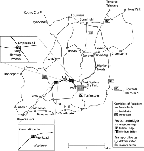
Alongside these interventions, Mayor Parks Tau (2011–2016) launched an ambitious plan dubbed the Corridors of Freedom, to make the city more compact (see, ). The plan for transit-oriented development proposed a series of interventions that combined new transport infrastructure with high-density residential, retail, business, educational, and leisure facilities (For fuller treatment of issues of density, compaction and land use mix see, Wood, Citation2021). A tenfold increase in density of 40,000 people/km2 and a morphology of 10–12 story-buildings was recommended (interview, town planner, Johannesburg, 12/2019). Three corridors were selected—the CBD to Soweto along Empire and Perth Road which follows Rea VayaFootnote1 Phase 1B (City of Johannesburg, Citation2012a), Louis Botha Road in support of Rea Vaya Phase 1C (City of Johannesburg, Citation2012b) and Turffontein node, a working class district south of the CBD (City of Johannesburg, Citation2012c)—and three strategic area frameworks were drafted. Each of these plans acknowledges a central role for walking and walkability to transform the economic and social fabric of Johannesburg. “NMT is a crucial part of the transport system” contends the Strategic Area Framework for the Empire-Perth Development Corridor, and “everyone should have access to urban opportunities and mobility with the necessary safety precautions in place” (City of Johannesburg, Citation2012a, p. 26). In addition to upgrading parks, clinics, libraries and sports facilities, the Corridors of Freedom plans for pedestrian bridges across highways and railway lines (e.g., the Grayston Pedestrian Bridge, the Milpark pedestrian bridge and the Westbury Bridge). These walkways were selected for their potential to connect rich and poor, white and black, residential and commercial areas in adherence with the 2013 Complete Streets Design Guidelines. The following section discusses the implications of these infrastructures on walkability in Johannesburg.
Figure 1. Illustrative map of Johannesburg’s Corridors of Freedom (Louis Botha, Empire-Perth and Turffontein) and pedestrian bridges (Grayston, Milpark and Westbury Bridges) (map made by author 8/2021).
Pedestrian projects
In accordance with the City’s walkability policies, a variety of pedestrian projects were introduced: sidewalks and crosswalks (JDA, Citation2018a); pedestrian-oriented land use and building design (JDA, Citation2018b); increased road connectivity with additional shortcuts for pedestrians and cyclists (JDA, Citation2020); traffic calming measures and vehicle restrictions (JDA, Citation2018a); safety education and law enforcement (JDA, Citation2018b); and vehicle parking policies and fuel taxes (JDA, Citation2018b). There were also less costly investments in trees and shrubs, lighting, benches and security cameras (JDA, Citation2015b). Pedestrian bridges, sometimes called footbridges or overpasses, were the most elaborate, expensive and visible outcome of this investment, and the projects that demonstrate the City’s attention to traversablity (interview, town planner 2, Johannesburg, 01/2020).
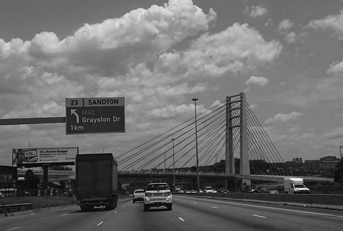
One example, the Grayston Pedestrian and Cycle Bridge (see, ), which opened in March 2018 and forms part of the Great Walk, is a multimillion Rand high-profile investment to support walking between Alexandra (a historically black area and now a very deprived neighborhood) and Sandton (Johannesburg’s secondary CBD and Africa’s wealthiest square-mile, home to international companies and the city’s wealthy elite). The Great Walk is a pseudonym for the 5.2-kilometer journey made by an estimated 10,000 domestic workers, gardeners and shop workers walking across Johannesburg’s busiest highway, the M1, every morning and evening. According to the City, the pedestrian bridge is expected to have far-reaching impact by replacing a previously a dangerous and difficult trek, with people scurrying along the concrete shoulder of a car-bridge and/or walking circuitous routes to avoid vehicular traffic (JDA, Citation2015a). The Grayston Bridge is not only meant to provide a new pedestrian experience, but also to transform the profile and practices of walking in both the wealthy and deprived parts of the city. The bridge according to Christine Walters, then-Mayoral Committee for Transport, “literally bridges the divide between these two contrasting communities and creates a visual gateway into the economic heartbeat of our city” (City of Johannesburg, Citation2015). Likewise the Grayston Bridge serves as a synonym for good transport planning. Sello Lemao, then-Member of the Mayoral Committee for Public Safety, concluded that transport interventions such as the pedestrian bridge served to transform the city making it more “sustainable, livable and economically vibrant” (City of Johannesburg, Citation2015). The extent to which infrastructure like the Grayston Bridge actually transformed walkability in Johannesburg warrants further reflection, a topic to which this paper now turns.
Figure 2. The Grayston Pedestrian and Cycle Bridge crosses the M1 highway between Alexandra and Sandton (photo by author 02/2020).
Misunderstandings of walkability in Johannesburg
In May 2019, the City conducted an assessment of non-motorized transport on Grayston Drive. Of the more than 5,000 pedestrians crossing the M1 highway on Grayston Drive, only 26% used the pedestrian bridge. The remaining majority of pedestrians continued to walk on the original footpath on the southern side of the vehicle lanes on Grayston Drive (Loots, Citation2019). The report goes on to suggest that widening existing sidewalks on either side of the vehicle bridge “might have been a more cost-effective way of solving the problem” (Loots, Citation2019, p. 6). Moreover, such an approach would have better considered “the people who need to cross the bridge between Alexandra and Sandton,” the report concludes (Loots, Citation2019, p. 6).
For Johannesburg planners, the success of walkability projects like the Grayston Bridge is measured by an increase in the number of pedestrians, pedestrian safety, public transport ridership and economic activity (interview, town planner 2, Johannesburg, 01/2020). None of these metrics were achieved through the Grayston Bridge—pedestrian usage, pedestrian safety, public transport ridership and economic activity are all below anticipated levels (Loots, Citation2019). Moreover, with increased costs, long delays and widely publicized accidents, critics question the investment in pedestrian bridges (Brown, Citation2015). For the most part, the wealthy residents of Sandton still frown upon pedestrianization while poorer Alexandra remains chronically underinvested (Kekana & Allison, Citation2019). Critics go further, alluding to the unpleasantness of walking by calling it preposterous to presume that a pedestrian bridge would improve the experience of pedestrians when the vast majority of the pathways remain unpaved and unnoticed (interview, town planner 1, Johannesburg, 01/2020). Likewise, projects like the Grayston Bridge were not designed with the pedestrian in mind. Pedestrian bridges are “flashy” explains a transport consultant in Johannesburg, “but without changing people’s approach to walking … so it becomes a very expensive way to deliver an otherwise cheap mode of transport” (interview, transport consultant, Johannesburg, 01/2020). Another expert recalled his ambitions for a shift in how Johannesburg residents shop: “We had imagined that with more people walking there would be more retail activity on the ground-floor level, but none of that has happened” (interview, town planner 1, Johannesburg, 01/2020).
The unpleasantness of walking
The Milpark Pedestrian Bridge, completed in December 2019, provides an example of how the City has misunderstood who is actually using the pedestrian bridges. The Milpark Bridge sits at the intersection of Barry Hertzog Avenue and Empire Road (two four-lane arterials) (see, ), in an area that incorporates a mixture of land uses including business, retail, residential, education, and health facilities. High traffic volumes on both Barry Hertzog Avenue and Empire Road were seen as obstacles to pedestrian movement, creating disconnections between institutions and landmarks. Rather than focusing on the underprivileged pedestrian, the bridge was conceptualized to attract high-end commercial and residential density to the area (JDA, Citation2020). It also targeted students traveling along the BRT to the two universities (University of Witwatersrand and University of Johannesburg) (interview, town planner 2, Johannesburg, 01/2020). As a result, there were missed opportunities to introduce a diversity of low-scale businesses such as fruit sellers, newspaper stands and snack shops (interview, town planner 1, Johannesburg, 01/2020). Existing pedestrians and their daily needs were insufficiently considered, and the resulting bridge therefore not only fails to attract additional walkers, but also fails to provide an enhanced experience for existing pedestrians.
The Milpark Pedestrian Bridge provides an opportunity to reflect on the extent to which walking is thought to be a universal good with many benefits (Litman, Citation2015; Southworth, Citation2005): it is cost-effective, flexible to the changing economic and social opportunities, healthy for pedestrians and sustainable for the environment (Ewing & Cervero, Citation2010). There is, however, a noteworthy disagreeableness to walking—it is time-consuming, slow, uncomfortable, and at times dangerous for the pedestrians, and it is contingent on the physicality of the pedestrian as well as the urban conditions available. Some of these challenges (e.g., the urban conditions) can be overcome by policy and infrastructure, but others (e.g., physicality of walking) cannot. People walk in Johannesburg because they are “transport poor.” According to Lucas (Citation2018) a person is transport poor if any of the following conditions apply: the transport options do not reach either the origin and/or the destination; the available transport modes are not suited to the person’s physical capabilities; the cost of transport pushes the household below the poverty line or the duration of the journey is excessive; or the conditions of the journey are unsafe or otherwise unhealthy. Under any of these circumstances, a person’s quality of life, health or opportunities for improvement will be restricted. In Johannesburg, “people walk extremely long distances to avoid paying for transport” (interview, transport consultant, 10/2019). Low income earners spend more than 25% of their monthly earnings on transport, and high unemployment further limits modal choice (Ratshilumela, Citation2018). Consequently, walkability should have been motivated by a pro-poor agenda that recognizes walking not only as the last-mile of motorized transport but a complete transport option. Likewise a pro-poor agenda recognizes the value of walking as a resource available to all people. Policies and projects in Johannesburg are unfortunately inadequately aligned with this understanding of walkability, and therefore fail to adequately cater to the pedestrian experience.
Walkability-with-people
The Westbury Pedestrian Bridge and Park provides an opportunity to reflect on how walkability projects can fuel, and be fueled by, partnerships between the city and the community. Situated between two deprived communities, Coronationville and Westbury, the infrastructure literally aims to bridge a divide (see, ). Interestingly, the need for this pedestrian bridge came from the Westbury community itself, who during a stakeholder consultation with the city requested a pedestrian bridge for people to move safely across Fuel Road. In 2013, the City surveyed 6,300 households across the city asking them about their transport movements and levels of satisfaction. Issues of last mile accessibility were identified. The City then held workshops asking stakeholders—councilors, transport operators, residents associations, and commuter groups—to outline their transport challenges and their views on the proposed plans (Transport Department, Citation2016). The community expressed concern that the existing on-grade crossing was dangerous not only for pedestrians but also for school children. They also complained that the new Rea Vaya station was difficult to access without an overheard connection. In response to these stakeholder engagements, the city then commissioned a study that revealed that over 500 people per hour cross during the morning and evening peak times (JDA, Citation2016). The resulting bridge, however, fails to incorporate much of what the community wanted: it includes a park for instance, which cost R25 million but without adequate security, this space turns into a no-go area after dark. Moreover, it is particularly dangerous for school children during the day. The community requested a safe pathway across the road but by replacing one problem—the dangers of traffic—the City facilitated another safety concern—crime. This is an example of a missed opportunity to collaborate on the design and development of a walkability project in Johannesburg.
This leads to the second criticism of Johannesburg’s policies and project: city officials failed to develop schemes that encourage walkability-with-people. Johannesburg’s policies tend to presume residents to be the users rather than the drivers of better urban planning (interview, transport consultant, 10/2019). Accordingly, the City assumes a weighty role for urban planners in guiding walkability (interview, city planner, 12/2019) and while it is certainly important for cities to put forward frameworks and policies, the agenda should be built in partnership with local communities. Indeed, there is opportunity as well as need to develop policy alternatives “that maximize the minimum level of primary goods to the people in the worst-off position” (Pereira et al., Citation2017, p. 175) so that “everybody should be well-off up to a certain minimum threshold” (Lucas et al., Citation2016, p. 477). This would fulfill a transport-justice mission (Rigolon et al., Citation2018), as well as enable cities to develop transport solutions that actually work for the community utilizing them.
Conclusion
An African flâneur, as depicted in Ivan Vladislavić’s novel Portrait with Keys (Vladislavic, Citation2006), is “anxiously alert, but nevertheless manages to immerse himself in the city” (Gaylard, Citation2017, p. 57). For many, “Johannesburg discourages flâneurism,” writes Gaylard (Citation2017, p. 60); indeed, “the people who walk Johannesburg daily are not flâneurs at all, but migrants, or workers, to whom the city still denies the right to public transport” (Gevisser, Citation2014, p. 20). “It takes a person of some physical stature and courage to roam its streets” continues Gaylard (Citation2017, p. 60), those “who pound the pavements on a daily basis do not do so with impunity and without trepidation.” I introduce the concept of an “African flâneur” to draw attention to the important role of the pedestrian, rather than the infrastructure, in walkability projects. Too much attention is paid to the glitzy infrastructure in Johannesburg, and not enough attention is paid to the people actually using it. As a result, much of it is under-utilized.
The concept of the “African flâneur” is also relevant to transport planning. Rather than proving the merits of walkability or the ease of its application, this paper highlights the challenges of actually doing walkability. First by contemplating the varied definitions of walkability, the paper reveals an ambiguity between the literature that interprets it as a synonym for compactness or a substitute for traversability. Next, by considering how walkability has influenced, and been influenced by, urban development. I then apply the concept of walkability to Johannesburg by examining policies that promote compactness and infrastructure projects that enable traversability. While the municipality uses walkability as a synonym for livability and sustainability, without a clear focus on the pedestrian these concepts prove difficult to apply. This leads to a discussion of the shortcomings of Johannesburg’s planning to explain why walkability has failed to take root. This is not to dwell on the failures in Johannesburg, but rather to reflect on the limitations of the focus on walkability and the challenges that emerge in its application.
This paper contributes to the field of urban studies by first providing an example of urban planning in an African/Global South city, and second attempting to decolonize transport planning by highlighting Johannesburg’s experiences. A decolonized approach to transport planning brings pedestrians and pedestrianization to the forefront. Rather than being seen as a marginal modality or a last-mile alternative, the logic of decolonizing turns walking into a primary mode of transport. Just as the settler-colonials subsumed economic, cultural and social life, they also created a hegemony of car-usage. Decolonizing therefore means also restoring power to pedestrians. This call to decolonize is particularly salient in South Africa, where transport has historically been used to control and divide cities. This study of walkability thus fits within ongoing efforts to remedy inequalities in transport, by elevating the role of pedestrians and calling for better infrastructure to support pedestrianization. In reflecting on the concept of walkability, I hope that city planners in Johannesburg (and beyond) will design and develop spaces that encourage and enhance walking for all.
Acknowledgments
This paper is the product of many years of research and I would like to thank those who have helped me refine and improve it. I am especially indebted to the delegates at the 2021 “Im/mobile Lives in Turbulent Times” conference whose remarks helped further the analysis. Any mistakes herein are all my own.
Disclosure statement
No potential conflict of interest was reported by the author(s).
Additional information
Notes on contributors
Astrid Wood
Astrid Wood is an Assistant Professor in the School of Geography, Politics and Sociology at Newcastle University in the United Kingdom. Dr. Wood is an urban geographer specializing in infrastructure, governance and transport. She is the author of How Cities Learn: Tracing Bus Rapid Transit in South Africa (2022) as well as over 30 peer-reviewed book chapters and journal articles on transport and urban studies.
Notes
1. In 2009, Johannesburg launched Rea Vaya as the first full-feature bus rapid transit (BRT) system in Africa. Originally from Bogota, BRT is a concept of high-quality bus-based transport that combines the quality of rail with the flexibility of buses. The introduction of Rea Vaya was accompanied by considerable investment in transport transformation across the city. (For lengthier discussion of BRT in Johannesburg see, Wood, Citation2014.)
References
- Alca˘ntara De Vasconcellos, E. (2004). The use of streets: A reassessment and tribute to Donald Appleyard. Journal of Urban Design, 9(1), 3–22. https://doi.org/10.1080/1357480042000187686
- Anciaes, P. R., Nascimento, J., & Silva, S. (2017). The distribution of walkability in an African city: Praia, Cabo Verde. Cities, 67, 9–20. https://www.sciencedirect.com/science/article/abs/pii/S0264275116306023
- Appelhans, N., Scholz, W., & Baumgart, S. (Eds.). (2021). Transport planning and mobility in urban East Africa. Routledge.
- Appleyard, D. (1981). Liveable streets. University of California Press.
- Beavon, K. (2004). Johannesburg: The making and shaping of the city. UNISA Press.
- Behrens, R. (2005). Accommodating walking as a travel mode in South African cities: Towards improved neighborhood movement. Planning Practice and Research, 20(2), 163–182. https://www.tandfonline.com/doi/abs/10.1080/02697450500414686
- Bremner, L. (2004). Johannesburg: One city colliding worlds. Real African Publishers.
- Brown, R. L. (2015, February 2). In Johannesburg, a new bridge must also address Apartheid’s legacy—Bloomberg. Bloomberg City Lab. https://www.bloomberg.com/news/articles/2015-02-02/in-johannesburg-a-new-bridge-must-also-address-apartheid-s-legacy
- Buchanan, C. (1963). Traffic in towns. Penguin Books.
- Cabaret, A. (2012). Back to the streets: Exploratory research on pedestrian life and walking spaces in the greater Johannesburg area. University of the Witwatersrand.
- Chen, N. (2019). Beyond mobility: Planning cities for people and places. Journal of Urban Affairs, 41(8), 1227–1229. https://www.tandfonline.com/doi/abs/10.1080/07352166.2019.1575144?journalCode=ujua20
- City of Johannesburg. (2009). Framework for non-motorized transport. Department of Planning and Urban Management.
- City of Johannesburg. (2012a). Strategic area framework: Empire Perth Development Corridor. https://www.gpma.co.za/files/EMPIRE_PERTH_SAF_FINAL_DRAFT.pdf
- City of Johannesburg. (2012b). Strategic area framework: Louis Botha Development Corridor. https://4crdug1m1izqix01u1hvesh1-wpengine.netdna-ssl.com/wp-content/uploads/attachments/louis-botha-final-sajr.pdf?sfvrsn=2
- City of Johannesburg. (2012c). Strategic area framework: Turffontein Development Corridor. https://www.gpma.co.za/files/TURFFONTEIN_SAF_FINAL_DRAFT.pdf
- City of Johannesburg. (2013a). Complete streets design guidelines.
- City of Johannesburg. (2013b). Strategic integrated transport framework. Department of Transport.
- City of Johannesburg. (2015). Construction of the ‘Great Walk’ bridge commences. Johannesburg Development Agency.
- Craggs, R., & Neate, H. (2019). What happens if we start from Nigeria? Diversifying histories of geography. Annals of the American Association of Geographers, 110(3), 899–916. https://doi.org/10.1080/24694452.2019.1631748
- Dovey, K., & Pafka, E. (2020). What is walkability? The urban DMA. Urban Studies, 57(1), 93–108. https://doi.org/10.1177/0042098018819727
- Ewing, R., & Cervero, R. (2010). Travel and the built environment: A meta-analysis. Journal of the American Planning Association, 76(3), 265–294. https://www.tandfonline.com/doi/abs/10.1080/01944361003766766
- Fang, K. (2013). Urban design manual for non-motorized transport-friendly neighborhoods. World Bank.
- Fanon, F. (1961). The wretched of the earth. Penguin Press.
- Forsyth, A. (2015). What is a walkable place? The walkability debate in urban design. URBAN DESIGN International, 20(4), 274–292. https://doi.org/10.1057/udi.2015.22
- Forsyth, A., & Southworth, M. (2008). Cities afoot—Pedestrians, walkability and urban design. Journal of Urban Design, 13(1), 1–3. https://www.tandfonline.com/doi/abs/10.1080/13574800701816896?journalCode=cjud20
- Gauteng Department of Roads and Transport. (2020). Gauteng province household travel survey report.
- Gaylard, G. (2017). An African Flaneur? Walking in Johannesburg in Portrait with Keys. In O. Moreillon, A. Muller, & L. Stiebel (Eds.), Cities in flux: Metropolitan spaces in South African literary and visual texts (pp. 57–72). Lit Verlag.
- Gevisser, M. (2014). Lost and found in Johannesburg. Jonathan Ball.
- Goldsmith, S. (1963). Designing for the disabled: The new paradigm. Routledge.
- Guerra, E., Cervero, R., & Al, S. (2017). Beyond mobility: Planning cities for people and places. Island Press.
- Harber, J., Parker, A., Joseph, K., & Maree, G. (2018). Taking streets seriously. Gauteng City Region Observatory.
- Hart, G. H. T. (1984). Urban transport, urban form and discrimination in Johannesburg. South African Geographical Journal, 66(2), 152–167. https://www.tandfonline.com/doi/abs/10.1080/03736245.1984.10559696
- ITDP. (2018). Pedestrians first: A tool for walkable cities. Institute for Transportation and Development Policy.
- Jacobs, J. (1961). The death and life of great American cities. Vintage Books.
- JDA. (2015a). Great Walk will link Alex and Sandton over the M1. Johannesburg Development Agency.
- JDA. (2015b). Construction of R130m Alex-Sandton bridge gets under way. Johannesburg Development Agency.
- JDA. (2016). Westbury’s new Corridor of Freedom landmark starts taking shape. Johannesburg Development Agency.
- JDA. (2018a). Westdene dam precinct interventions/NMT. Johannesburg Development Agency.
- JDA. (2018b). Non-motorised transport (NMT) project under construction—Westbury Development Renewal Precinct – NMT phase 4. Johannesburg Development Agency.
- JDA. (2020). Milpark pedestrian bridge reaches practical completion. Johannesburg Development Agency.
- Kekana, M., & Allison, S. (2019, November 12). Bridges only work when both sides cross them. YES! Magazine.
- Khayesi, M., Monheim, H., & Nebe, J. M. (2010). Negotiating “streets for all” in urban transport planning: The case for pedestrians, cyclists and street vendors in Nairobi, Kenya. Antipode, 42(1), 103–126. https://onlinelibrary.wiley.com/doi/abs/10.1111/j.1467-8330.2009.00733.x
- Krambeck, H. V. (2006). The global walkability index. Massachusetts Institute of Technology.
- Labuschagne, K., & Ribbens, H. (2014). Walk the talk on the mainstreaming of non-motorised transport in South Africa, Paper presented at the 33rd Annual Southern African Transport Conference, 7-10 July 2014 “Leading Transport into the Future” (pp. 191–206), CSIR International Convention Centre, Pretoria, South Africa. https://repository.up.ac.za/handle/2263/45524
- Lauster, M. (2007). Walter Benjamin’s myth of the “Flâneur.” The Modern Language Review, 102(1), 139–156. https://www.jstor.org/stable/20467157
- Leslie, E., Saelens, B., Frank, L., Owen, N., Bauman, A., Coffee, N., & Hugo, G. (2005). Residents’ perceptions of walkability attributes in objectively different neighbourhoods: A pilot study. Health & Place, 11(3), 227–236. https://www.sciencedirect.com/science/article/abs/pii/S1353829204000401
- Litman, T. (2003). Economic value of walkability. Transportation Research Record, 1828(1), 3–11. https://journals.sagepub.com/doi/abs/10.3141/1828-01
- Litman, T. (2015). Evaluating complete streets: The value of designing roads for diverse modes, users and activities ( pp. 29). Victoria Transport Policy Institute.
- Lo, R. H. (2009). Walkability: What is it? Journal of Urbanism, 2(2), 145–166. https://www.tandfonline.com/doi/abs/10.1080/17549170903092867
- Loots, A. (2019). Great walk: Assessment of NMT interventions by the JDA. Johannesburg Development Agency.
- Lucas, K. (2018). Editorial for special issue of European Transport Research Review: Transport poverty and inequalities. European Transport Research Review, 10(17), 1–3. https://etrr.springeropen.com/articles/10.1007/s12544-018-0288-6
- Lucas, K., Van Wee, B., & Maat, K. (2016). A method to evaluate equitable accessibility: Combining ethical theories and accessibility-based approaches. Transportation, 43, 473–490. https://link.springer.com/article/10.1007/s11116-015-9585-2
- Manaugh, K., & El-Geneidy, A. (2011). Validating walkability indices: How do different households respond to the walkability of their neighborhood? Transportation Research Part D, 16(4), 309–315. https://www.sciencedirect.com/science/article/abs/pii/S1361920911000216
- McCann, B., & Rynne, S. (2017). Complete streets: Best policy and implementation practices (no. 559). American Planning Association.
- McCool, A. (2016, December 16). A walk to freedom: Can Joburg’s bridges heal the urban scars of apartheid? The Guardian.
- Merriam-Webster Dictionary. (2016). Pedestrian. In Merriam-Webster Dictionary. Merriam Webster.
- Mitullah, W. V., Vanderschuren, M., & Khayesi, M. (Eds.). (2017). Non-motorized transport integration into urban transport planning in Africa. Routledge.
- Montgomery, B., & Roberts, P. (2008). Walk urban: Demand, constraints and measurement of the urban pedestrian environment ( pp. 1–29). World Bank.
- National Land Transport Act, Parliament. (2009) (testimony of National Department of Transport).
- Nyamai, D. N. (2021). Urban mobility and spatial justice: Prospects of non-motorized transport in Nairobi. In N. Appelhans, W. Scholz, & S. Baumgart (Eds.), Transport planning and mobility in urban East Africa (pp. 31–42). Routledge.
- Olvera, D., Plat, D., Pochet, P., & Sahabana, M. (2010). Motorized two-wheelers in Sub-Saharan African cities: Public and private use. 12th World Conference on Transport Research, 1–17. http://www.wctr2010.info/WCTR_General/documents/02223.pdf
- Oxford English Dictionary. (2012). Pedestrian. In Oxford English dictionary. Oxford University Press.
- Pendakur, V. S. (2005). Non-motorized transport in African cities (SSATP Working Paper No. 80). World Bank.
- Pereira, R. H. M., Schwanen, T., & Banister, D. (2017). Distributive justice and equity in transportation. Transport Reviews, 37(2), 170–191. https://www.tandfonline.com/doi/abs/10.1080/01441647.2016.1257660
- Pharoah, T., & Buchan, K. (1997). Putting London back on its feet. London Planning Advisory Committee.
- Pieterse, E., & Owens, K. (2018). Johannesburg: Confronting spatial inequality. World Resources Institute.
- Pirie, G. (2014). Transport pressures in urban Africa: Practices, policies, perspectives. In S. Parnell & E. Pieterse (Eds.), Africa’s urban revolution (pp. 133–147). Zed Books Ltd.
- Priya Uteng, T., & Lucas, K. (Eds.). (2018). Urban mobilities in the Global South. Routledge.
- Prytherch, D. (2018). Law, engineering and the American right-of-way. Palgrave Macmillan.
- Ratshilumela, T. (2018, July 25). Non-motorized transport infrastructure—“complete street.” Masterclass on Transport Planning.
- Rigolon, A., Toker, Z., & Gasparian, N. (2018). Who has more walkable routes to parks? An environmental justice study of safe routes to parks in neighborhoods of Los Angeles. Journal of Urban Affairs, 40(4), 576–591. https://doi.org/10.1080/07352166.2017.1360740
- Road Traffic Management Corporation. (2018). State of the road report. National Department of Transport.
- Said, E. W. (1978). Orientalism. Random House.
- Southworth, M. (2005). Designing the walkable city. Journal of Urban Planning and Development, 131(4), 246–257. https://ascelibrary.org/doi/abs/10.1061/(ASCE)0733-9488(2005)131:4(246)
- Spivak, G. C. (1988). Can the subaltern speak? In C. Nelson & L. Grossberg (Eds.), Marxism and the interpretation of culture (pp. 271–316). University of Illinois Press.
- Transport Department. (2016, March 23). Integrated transport network and implications for the city. Economic Growth, Technical EMT.
- U.S. Department of Transportation. (1997). Walkability checklist: How walkable is your community?
- Uteng, T. P., & Lucas, K. (Eds.). (2017). Urban mobilities in the Global South. Routledge.
- Van Wee, B., & Geurs, K. (2011). Discussing equity and social exclusion in accessibility evaluations. EJTIR, 11(4). https://journals.open.tudelft.nl/ejtir/article/view/2940
- Vladislavic, I. (2006). Portrait with Keys: The city of Johannesburg unlocked. Portobello Books.
- Whol, M., & Martin, B. (1967). Traffic system analysis for engineers and planners. McGraw-Hill.
- Wood, A. (2014). Moving policy: Global and local characters circulating bus rapid transit through South African cities. Urban Geography, 35(8), 1238–1254. https://www.tandfonline.com/doi/abs/10.1080/02723638.2014.954459
- Wood, A. (2015). Multiple temporalities of policy circulation: Gradual, repetitive and delayed processes of BRT adoption in South African cities. International Journal of Urban and Regional Research, 39(3), 568–580. https://onlinelibrary.wiley.com/doi/full/10.1111/1468-2427.12216
- Wood, A. (2020). Tracing the absence of bike-share in Johannesburg: A case of policy mobilities and non-adoption. Journal of Transport Geography, 83, 102659. https://www.sciencedirect.com/science/article/abs/pii/S0966692319305009
- Wood, A. (2021). Problematizing concepts of transit-oriented development in South African cities. Urban Studies.
- Wood, A., Kębłowski, W., & Tuvikene, T. (2020). Decolonial approaches to urban transport geographies: Introduction to the special issue. Journal of Transport Geography, 88, 102811. https://www.sciencedirect.com/science/article/abs/pii/S096669232030747X?via%3Dihub
- Zavetoski, S., & Agyeman, J. (Eds.). (2015). Incomplete streets: Processes, practices and possibilities. Routledge.