
 ?Mathematical formulae have been encoded as MathML and are displayed in this HTML version using MathJax in order to improve their display. Uncheck the box to turn MathJax off. This feature requires Javascript. Click on a formula to zoom.
ABSTRACT
In this paper we analyze changes in the intra-urban spatial distribution of employment across six U.S. and German city regions between 2002 and 2015. Our methodological approach allows for a systematic and spatially consistent comparison of urban spatial structures across the two different countries. The empirical results show major national, regional, and sectoral differences in the spatial distribution of employment. In the German case studies traditional core cities play a more important role for the regional labor market than in the U.S. Only relatively small shares of metropolitan employment are concentrated in subcenters. While employment concentrations are spatially less persistent in the U.S. case study regions, we did not find any evidence of common or country-specific trends toward increased polycentricity or employment dispersal. Changes in the spatial concentration of employment seem to be highly context-specific and influenced by the individual geographic and institutional frameworks of the analyzed metropolitan areas.
Introduction
Numerous empirical studies on urban spatial structure have shown that large metropolitan areas around the world are mostly non-monocentric. Although traditional central business districts (CBDs) have maintained their symbolic importance, many employment concentrations have emerged outside core cities, resulting in more polycentric or dispersed patterns (Garreau, Citation1991; Giuliano & Small, Citation1991; Guillain et al., Citation2006; Krehl, Citation2018; Krehl & Siedentop, Citation2018; Riguelle et al., Citation2007). While the analysis of the centripetal and centrifugal forces driving the concentration and dispersion of economic activity within city regions is as important today as it was 30 years ago, most empirical studies remain rooted in the 20th century and based on 20th-century data. Seminal studies on employment de-concentration and decentralization date back to the 1980s and 1990s, when urban economists and geographers claimed that the reconfiguration of urban spatial structure was closely related to the structural transition of western economies toward a post-industrial service economy (Anas et al., Citation1998; Scott, Citation1988). Large-scale investments in transportation systems and decreasing transportation costs allowed a more flexible entrepreneurial location choice within urban regions (Dielemann & Wegener, Citation2004). The rise of information and communication technologies (ICT), changes in production technologies, and new business models triggered debates over the “death of distance” and a more footloose nature of modern economies (Friedman, Citation2005; Gordon & Richardson, Citation1996; Negroponte, Citation1995).
However, in the course of the past 30 years, new trends in intra-metropolitan spatial development have emerged, with many traditional inner cities in the U.S. and Europe witnessing significant population and employment increases (Dembski et al., Citation2021; Haase et al., Citation2020; Hartley et al., Citation2015; Hyra, Citation2015). Scholars have explained this re-urbanization by the rise of the knowledge economy and the lasting relevance of face-to-face interaction as well as proximity to universities (Duvivier et al., Citation2018; Larsson, Citation2017; Spencer, Citation2015), the importance of inner cities as places of consumption (Glaeser & Gottlieb, Citation2006; Nichols Clark et al., Citation2002), and the residential preferences of the so-called creative class (Florida, Citation2002). These high-skilled individuals are characterized by their affinity to certain urban amenities such as historic structures, urban culture, and leisure opportunities more prevalent in downtown areas than in suburbia. While there is some evidence that firms are following the preferences of their highly qualified employees by moving their headquarters to downtown locations (Core Values, Citation2015), it remains unclear whether the enduring urban renaissance of the early 21st century has altered the trajectories of intra-urban employment concentrations.
In this paper, we address this research gap, analyzing changes in intra-urban employment concentration across six city regions in the U.S. and Germany (Atlanta, Pittsburgh, Seattle, Berlin, Hamburg, and Nuremberg), as well as across three core economic sectors (manufacturing, basic services, and advanced services). We argue that the recent wave of population growth in core cities is closely related to developments in intra-regional labor markets, suspecting slower de-concentration and decentralization in the advanced knowledge-intensive service sector. At the same time, however, we hypothesize that the increases in property prices and rents and the land use conflicts caused by the demographic revival of inner cities have led to the displacement of lower-skilled jobs to more peripheral locations. We therefore assume a simultaneous occurrence of centripetal and centrifugal forces, resulting in complex and contradictory changes of metropolitan employment patterns.
International comparative case studies allow us to test the validity of explanatory concepts across national and regional borders and to better distinguish between what is generalizable and what is particular and context-bound (Bourne, Citation2008). We aim to identify universal-systemic factors on the one hand and specific place-, time-, and culture-dependent factors on the other. The United States and Germany are suitable candidates for a comparative study of employment geographies, since relevant contextual factors such as the economic system, mobility and housing cultures, and state planning institutions diverge greatly.
We not only contribute to the emerging strand of empirical literature on changes in employment concentrations in the 21st century, currently focused on the U.S. (Buckwalter, Citation2021; Giuliano et al., Citation2022; Kane et al., Citation2018; Liu et al., Citation2019), but also add to the transatlantic debate on the evolution of urban form. While some authors claim that country- and region-specific factors such as path-dependent urban morphologies, infrastructure systems, economic structures, varying demographic trajectories, and different cultural and planning institutions lead to diverging developments in urban spatial structure (Bourne, Citation2008; Heider & Siedentop, Citation2020; Shearmur & Coffey, Citation2002), others argue that city regions in Western Europe and North America show strongly convergent developments. In this view processes of decentralization are prevalent features of prosperous cities in the Global North caused by universal forces of economic and social change (Bae & Richardson, Citation2004; Gordon & Cox, Citation2012).
Our comparative research strategy thus aims to reveal patterns of convergence and divergence (Kantor & Savitch, Citation2005; Pierre, Citation2005). The selection of case regions (see Section 3) is based on the “most-different-systems” design, according to which cases are selected that differ strongly in their institutional conditions (e.g., national policy systems, local-regional planning institutions, divergent market dynamics, and cultural preferences), but show similar characteristics in the observed phenomenon. The latter refers to the dynamic restructuring processes of intra-urban employment found in both countries. With a view to Pickvance’s approach of “plural causation” (Pickvance, Citation2001), we further argue that a given phenomenon (in particular, the change in urban spatial structure) can be explained by different combinations of explanatory variables. Thus, our research strategy is a differentiating comparative analysis with plural causation.
The empirical approach allows a systematic comparison of intra-urban employment geographies across two different countries. Instead of administrative territories such as census tracts or municipalities which are spatially inconsistent across countries, we use 1 km × 1 km grid cells as the spatial aggregation unit. This enables us to circumvent some of the problems that plague quantitative research comparing countries with differing statistical reporting systems and differing shapes of administrative areas.
The remaining part of this contribution is organized as follows: based on an extensive literature review, we explain the comparative research approach and the data and methods employed. Afterward, we present the empirical findings followed by a discussion and conclusions for future research.
Literature review
In the second half of the 20th century, researchers observed a spatial redistribution of employment toward new locations farther away from the urban core in many American and European city regions (Garreau, Citation1991; Giuliano & Small, Citation1991; Guillain et al., Citation2006; Riguelle et al., Citation2007). Particularly influential were the investigations conducted by Garreau (Citation1991) who also coined the term edge cities for suburban employment concentrations. While polycentricity has since become a key concept in regional research and planning, the term is used in many different ways and has various meanings (e.g., intra-urban vs. inter-urban, morphological vs. functional polycentricity, polycentricity as a normative planning concept, etc.; for an overview see, Kloosterman & Musterd, Citation2001; Münter & Volgmann, Citation2021). In their scientometric study on the stretched concept of polycentricity in urban research, Van Meeteren et al. (Citation2016) highlighted that most studies on inter-urban polycentricity are based on European case studies, whereas the concept of intra-urban polycentricity is mainly rooted in the U.S. literature.
In this paper, we focus our analysis on intra-urban polycentricity. This means that our main interest is the analysis of the development of employment centers at a relatively fine spatial scale in historically rather monocentric city regions. Since data on the functional linkages (e.g., commuting flows) between different locations is not available at this scale—at least in Germany—we also have to restrict our analysis to morphological polycentricity.
Evolving intra-urban morphological polycentricity can generally be understood as the formation of new employment concentrations in the periphery of formerly more or less monocentric regions. But polycentricity means more than the sheer existence of multiple employment hubs. A polycentric urban system is characterized by a flat hierarchy between its centers. Under perfect polycentricity all centers are of equal size and a major center is not discernible. While urban scholars have emphasized several factors to explain the phenomenon of polycentric development, the evolution of new employment centers can generally be understood as the interplay between negative (centrifugal) and positive (centripetal) agglomeration externalities (Anas et al., Citation1998). Rising agglomeration costs associated with land scarcity, high land prices, traffic congestion, and pollution in urban cores are incentivizing firms to move to peripheral locations. Meanwhile agglomeration benefits such as resource-sharing and the faster transfer of tacit knowledge within and between firms are leading to the emergence of new employment clusters in the urban hinterland. Such job-rich areas are often located near major metropolitan transport network nodes, benefiting workers and consumers alike (Giuliano et al., Citation2011).
While—at least for U.S. metropolitan areas—there is a relatively clear consensus that core cities had lost significant shares of employment by the end of the 20th century, some researchers have questioned the implicit assumption that the evolution of urban form necessarily results in polycentric structures. Gordon and Richardson (Citation1996) and Lang and LeFurgy (Citation2003) provided evidence of a spatial dispersal of employment rather than polycentric development. Comparative studies of urban spatial structures scrutinizing larger samples of metropolitan areas have revealed a variety of trajectories, including dispersive, polycentric, and even monocentric developments across different metropolitan areas (Heider & Siedentop, Citation2020; Lee, Citation2007). Hajrasouliha and Hamidi (Citation2017) concluded that the majority of metropolitan areas in the U.S. represent a hybrid form of urban spatial structure, with polycentricity and dispersion overlapping.
Another dimension of polycentric urban evolution are the different patterns of concentration across different sectors of the urban economy. Dependent on the economic sector in which they operate, firms have different land use requirements and benefit differently from spatial proximity to other firms. While manufacturing has a strong tendency toward decentralization and de-concentration due to its intense land use and environmental footprint (Heider & Siedentop, Citation2020), many authors have emphasized the role of knowledge-intensive sectors, especially higher order services, in the evolution of urban form (Muñiz & Garcia-López, Citation2010; Shearmur, Citation2012; Volgmann & Münter, Citation2018). Since knowledge-intensive and innovative activities are highly dependent on face-to-face contacts, they encourage spatial clustering. Their decentralization is therefore highly likely to result in thriving new employment concentrations in the urban hinterland (Spencer, Citation2015).
Given that the vast majority of empirical research on intra-urban employment concentrations stems from the U.S., we wonder whether the strongly market-driven phenomenon of employment decentralization leading to polycentric or dispersed urban forms apply to other countries in the Global North. Some authors have argued that there are substantial institutional differences between them, pointing to urban and regional planning systems, welfare state regimes, and historical urban morphologies and contending that it is therefore highly unlikely that the global forces of technological and industrial transformation will result in similar employment decentralization patterns (Dijst & Vázquez, Citation2007; Krehl & Siedentop, Citation2018). Most studies from European countries were rather modest in their conclusions about polycentric urban development. Suburban employment concentrations in Europe are economically less diverse and tend to complement a core city (Bontje & Burdack, Citation2005; Guillain et al., Citation2006; Riguelle et al., Citation2007). Particularly with regard to higher order services, traditional core cities continue to play a dominant role in explaining metropolitan employment distribution (Guillain et al., Citation2006; Riguelle et al., Citation2007). Other case studies have shown that strategic planning policies had a strong influence on subcenter formation in European city regions (Bontje & Burdack, Citation2005; Guillain et al., Citation2006; Schmidt et al., Citation2021; Shearmur & Alvergne, Citation2003). Polycentric urban development can therefore—in stark contrast to the U.S. (see, Agarwal, Citation2015)—not be conceptualized just as the outcome of market forces.
We argue that the literature on intra-urban polycentricity and employment concentrations lacks an international comparative perspective. While several authors have tried to transfer the theoretical concept of edge cities to a European context (Bontje & Burdack, Citation2005), or have applied similar empirical methods to identify employment subcenters in European city regions (Krehl, Citation2018), a systematic comparison of the development of employment concentrations across countries with strongly diverging institutional backgrounds is missing.
We thus identify three major research questions, which have not been sufficiently answered in the existing studies:
What are the differences in employment geographies of German metropolitan areas compared to their counterparts in the U.S.? Are there country-specific patterns or is the urban spatial structure of economic activity mostly dependent on individual geographic and historical conditions?
What are the trajectories of intra-metropolitan employment geographies in the 21st century? Is the dominant trend of the late 20th century toward more polycentric and/or dispersed urban structures continuing or does the recent trend of demographic re-urbanization correspond with a re-centralization of economic activities?
Is there a convergent or divergent trend of employment (de-)centralization between city regions in the U.S. and Germany or is the development of the intra-metropolitan distribution of employment highly case-specific?
International comparative approach and case study selection
In this paper, we compare development trends in urban spatial structure across a sample of case study regions in two countries—the U.S. and Germany—representing the two ends of the spectrum of governance and planning systems within the Global North (Schmidt et al., Citation2021). The U.S. represent a decentralized and economically liberal system in which the spatial configuration of economic activity is mostly determined by market forces and where local planning authorities have great autonomy. In contrast, Germany represents a social market economy, where market forces are to a large extent regulated by the state and where spatial planning is more or less regionally coordinated (Schmidt & Buehler, Citation2007; Schmidt et al., Citation2017).
Given these significant structural differences, we expect the global socioeconomic transformations of the 21st century such as digitalization, the ongoing transition toward a knowledge economy, and the renaissance of big cities to have resulted in dissimilar spatial employment configurations and trajectories in the two countries. In particular, we expect planning policies in Germany to have restricted the rather extreme developments of job sprawl and subcenter emergence observed in the U.S. (Schmidt et al., Citation2021).
Moreover, even within both countries, we expect the trajectories of urban spatial structure to diverge across individual city regions. While six case studies are by no means representative of each country’s entire urban system, we targeted diverse city regions with the aim of capturing the potential variety of development trends. To allow for greater comparability, we based our selection on several criteria. For example, our sample does not include extremely large metropolitan areas such as New York or Los Angeles, as similar-sized urban areas do not exist in Germany. In addition, our focus is on emerging employment concentrations in areas formerly dominated by a significant core city. Hence, we ignore city regions which have always been highly polycentric such as the San Francisco Bay Area or the Ruhr Area in Germany. Consequently, our sample of case studies is made up of four large city regions (Atlanta, Seattle, Berlin, and Hamburg) each with more than 1 million employees, and two smaller city regions (Pittsburgh and Nuremberg) with less than 1 million employees. Selected descriptive statistics on employment density and growth are listed in .
Table 1. Descriptive statistics for U.S. and German case study regions 2002, 2015.
Each of the selected city regions has distinguishing features. Atlanta is an economic powerhouse in the southeast of the U.S. Its rapid growth in the 1980s and 1990s was accompanied by massive urban sprawl and the suburbanization of population and employment (Brookings Institution Center on Urban and Metropolitan Policy, Citation2000). While Georgia is one of the few U.S. states with a growth management act enabling local and regional authorities to develop comprehensive long-term plans, their local implementation is not mandatory. Also, given Georgia’s highly fragmented political and administrative geography, it is questionable whether its growth management approach is effective in preventing urban sprawl and land conversion (Nelson, Citation1999).
Seattle is the major economic center of the Pacific Northwest. In contrast to many other growing city regions, its geographic expansion is restricted by the region’s fragmented natural geography, including larger nature conservation areas. In the past, the largest share of population and employment growth was located along the north-south coastline of Seattle (Robinson et al., Citation2005). Moreover, Washington is one of the few U.S. states with a growth management tradition (Carruthers, Citation2002). In the Seattle region, land use change is regulated by zoning and the designation of urban growth boundaries (Robinson et al., Citation2005).
Pittsburgh is the second-largest city in Pennsylvania. Following the demise of the U.S. steel industry in the 1970s, Pittsburgh went through a long period of de-industrialization and population decline. During our period of observation (2002–2015), Pittsburgh was characterized by substantial sectoral and spatial restructuring (Buckwalter, Citation2021). Due to its industrial history, the development of urban spatial structure in the second half of the 20th century did not mirror national trends of growth-induced sprawl. Instead, the decentralization of the population and economic activity was accommodated within the moderately decentralized patterns that emerged between 1880 and 1920, driven by an expanding heavy manufacturing industry (Gleeson & Paytas, Citation2005). From a growth management perspective, Pennsylvania belongs to the majority of U.S. states without a comprehensive growth management strategy.
Berlin is the capital of Germany and its largest city. Unlike most other major economic centers in Germany, Berlin’s economy is strongly dominated by service industries. In recent years, the city has developed into a hotspot for innovative start-ups (The Economist, Citation2020). Due to its unique history in the second half of the 20th century, Berlin’s economic and spatial development did not feature any de-concentration or sprawl. It was only after the German reunification (1990) that a wave of residential and economic suburbanization emerged (Schmidt, Citation2013). While the city of Berlin is a German federal state in its own right, the city region of Berlin extends to the surrounding federal state of Brandenburg, resulting in overlapping planning regions. However, since Brandenburg is one of Germany’s most sparsely populated federal states and has suffered from population shrinkage since German reunification, growth management policies within these planning regions are among the weakest in Germany (Siedentop & Pehlke, Citation2021).
Hamburg is Germany’s second-largest city and one of its most dynamic regions. Maritime industries, aviation, IT and the media are among Hamburg’s key employment sectors (Görlinger et al., Citation2013). While the region has historically been rather monocentric, the city region also incorporates medium-sized cities such as Lübeck and Lüneburg. Similar to Berlin, Hamburg is a German federal state in its own right, located between the federal states of Lower Saxony and Schleswig-Holstein. The metropolitan area thus features a strong spatial fragmentation of planning responsibilities. However, the planning regions in Lower Saxony, south of Hamburg, have implemented policies concentrating urban growth and reducing further land use change (Siedentop & Pehlke, Citation2021).
Similar to Pittsburgh, Nuremberg, Bavaria’s second-largest city region, has been through a phase of economic restructuring. Until the 1980s, the regional economy was dominated by industries such as electrical engineering and the production of household appliances. Many production sites have since been closed down, leading to significant losses of blue-collar jobs. Compared to other old industrial regions in Germany, the economic restructuring of the Nuremberg region has been a remarkable success story, with the region now being one of Germany’s more dynamic metropolitan areas, driven by a strong focus on knowledge-intensive activities (Dörre & Röttger, Citation2006). Historically, the region’s spatial structure has—to a certain degree—always been polycentric, with the cities of Fürth and Erlangen as secondary centers. In terms of land use regulation at the regional scale, the degree of development controls is comparatively low (Siedentop & Pehlke, Citation2021).
While diversity within both countries in terms of economic structure, geography, history and planning culture was the most important criterion for our selection of case study regions, we also find some parallels between the U.S. and German cases. Pittsburgh and Nuremberg are two medium-sized city regions which both went through a long period of economic restructuring. Seattle and Hamburg are important port cities and among the world’s most important locations of the aviation industry. Atlanta and Berlin are two booming city regions with a comparably low degree of growth management in the surrounding area.
Despite these similarities, we expect that the individual constellations of geographic, historic, economic and institutional conditions discussed above lead to diverging outcomes regarding the spatial concentration of employment across our case study regions. Since the interplay of causal factors is complex and hardly quantifiable, we did not specify individual hypotheses for our case study regions. We nevertheless assume some general patterns. First, we expect the spatial distribution of urban employment to be more concentrated and persistent in the German regions due to the historically established urban systems and the greater impact of planning regulations. Second, we hypothesize that within-country nuances are stronger in the U.S. where the economic and institutional environment features larger inter-regional variation. Third, we also expect different outcomes for old industrial city regions such as Pittsburgh and Nuremberg, where economic restructuring could have led to significant changes in the spatial distribution of metropolitan employment, e.g., in the form of declining old industrial sites or emerging employment concentrations in new industries in the urban hinterland.
Data and methods
Data
Researchers analyzing metropolitan spatial structure typically struggle with the challenge that the spatial units of aggregation—the main spatial reference of statistical offices—are too large to detect employment subcenters. This is particularly true for Germany, where the finest available unit of aggregation is usually the municipality. In the U.S., research on urban spatial structure is usually conducted at the spatial level of census tracts (Arribas-Bel & Sanz-Gracia, Citation2014), census block groups (Buckwalter, Citation2021) or traffic analysis zones (Giuliano & Small, Citation1991; McMillen, Citation2001). While these spatial units are significantly smaller than municipalities, there is also a great variation in size and shape.
In this study, we used two spatially fine-grained data sources on employment, allowing us to aggregate employment data at the very high resolution of 1 km × 1 km grid cells. This enabled a systematic comparison of the development of urban employment concentrations across metropolitan areas and countries. For Germany, we used the European INSPIRE grid, while for the U.S. we created an equivalent grid of identical cell size.
U.S. figures on the number of employees by industry (NAICS two-digit) are available at a very fine spatial unit of aggregation (Census Blocks) via the Longitudinal Employer-Household Dynamics Origin-Destination Employment Statistics (LODES; see, Graham et al., Citation2014). The LODES data is available for a time series spanning from 2002 to 2015. Consequently, in order to examine changes over the longest possible time period, we conducted our empirical analysis for the years 2002 and 2015. As Census blocks are on average smaller than 1 km2 grid cells, we were able to compute the number of employees per grid cell by superimposing our grid onto the census blocks.Footnote1
In Germany, the Establishment History Panel (BHP) of the Federal Institute for Employment Research (see, Ganzer et al., Citation2021) provides information about establishment-level employment. The georeferenced data is not available for public use, but the Data Center of the Federal Institute for Employment Research aggregated it to coarser spatial units upon request. Establishments are assigned to our 1 km2 grid according to their addresses.Footnote2 Employment within a grid cell then equals the sum of the number of employees at the establishments in that cell. As the BHP also contains information about the sector of economic activity an establishment is assigned to, sector-specific employment levels can be computed in addition to total employment. The provision of grid-level employment values is limited by several anonymity criteria according to German data protection laws. The dataset prepared by the Data Center does not provide any information if cells contain fewer than four establishments or if there are fewer than 10 employees. This is also the case if a single establishment accounts for more than 80% of total employment. For the empirical analysis, we manually set employment to three employees (and one employee for each economic sector as explained below) in cells for which no information about employment is provided. Our data allowed us to compare how the spatial distribution of employment develops across different economic sectors. Due to the above-described limitations, we chose a relatively coarse level of sectoral aggregation, distinguishing between employment in manufacturing, basic services and advanced (knowledge-intensive) services.Footnote3
Another challenge for international comparisons of urban spatial structure is the delineation of city regions. While core-based statistical areas (CBSAs) consisting of one or more core cities and all adjacent regions interconnected by significant commuting flows are a widely accepted concept in the U.S., there is no comparable definition in Germany.Footnote4 To achieve a comparable delineation across countries, we chose to define our research areas based on travel time isochrones. These travel time isochrones might not reflect the complexity of today’s polycentric city regions, but they are consistent with our analytical framework which focuses on intra-urban polycentricity in historically monocentric city regions. Using road network data, we computed the area accessible within a certain travel time from the city center. Travel times refer to a free flow road network without congestion. Since larger cities are assumed to attract commuters from further distances than smaller cities, we defined a maximum commuting time of 60 minutes for the four larger cities (Atlanta, Seattle, Berlin and Hamburg) and 45 minutes for the two smaller cities (Pittsburgh and Nuremberg).
We are aware that these thresholds are relatively arbitrary. However, we tested several travel time bands. According to our knowledge of the case study regions, the resulting areas adequately delineate the cities and their main catchment areas. The U.S. city regions delimited in this way are significantly smaller than the official metropolitan statistical areas, but metropolitan areas consist of multiple counties usually comprising large portions of unurbanized land, which are only marginally connected to the core city. Therefore, our travel time isochrones are better suited for the measurement of intra-urban polycentricity.
Identification of employment concentrations
There is abundant literature on the empirical identification of employment centers (for an overview see, Krehl, Citation2018). Following McMillen (Citation2003, Citation2004), a center is defined as a site that has a significantly higher employment density than adjacent areas and a significant impact on the overall spatial distribution of employment, population, and land prices. Earlier approaches (Giuliano & Small, Citation1991) have been criticized for relying on arbitrarily chosen density thresholds requiring a priori knowledge of regional spatial structures. Hence, recent studies have developed more sophisticated semi- or non-parametric methods for detecting employment centers (Krehl, Citation2018; McMillen, Citation2001; Sun, Citation2020).
One such method is the two-step procedure proposed by McMillen (Citation2001) which is based on the Locally Weighted Regression (LWR). LWR is a non-parametric regression approach that combines multiple regression models in a meta-model with locally varying beta-coefficients. It does this by fitting weighted models to localized subsets of the data to build up a smoothed regression surface, step by step. The weights for the regression models are given by the heights of a kernel function of the explanatory variables.
In a first step, candidate employment centers are identified with LWR used to fit a relatively smooth surface to the distribution of the log-employment density over a city region. The regression model is defined as:
where is the natural logarithm of employment density in area
and
is a vector of the distances north and east to the region’s major center.Footnote5 To obtain a fairly smooth density surface, the window size which defines the share of the geographically closest observations to add a weight in the estimation is 50% (for details on the calculation of the kernel weighting function see, McMillen, Citation2001). Spatial units with significantly positive residuals (p = .05) on the smoothed log-employment surface are then considered employment center candidates. To reduce patches of neighboring candidates to their center, a maximum filter retains only the spatial unit with the highest log-employment density in a three-mile radius. In a second step, semi-parametric regressions are iteratively applied to remove the center candidates with the lowest coefficients until only significantly influential employment centers remain.
Since first publication, several authors have modified McMillen’s (Citation2001) original LWR approach. For instance, Sun (Citation2020) made two methodological modifications to the approach: in the first step, he did not apply a spatial maximum filter, meaning that he obtained several adjacent spatial units with high employment densities instead of obtaining only the one with the peak value. Additionally, to identify significantly influential subcenters, Sun (Citation2020) did not use iterative regressions in the second step of the LWR but opted for a simpler threshold approach. Utilizing this method, he compares total employment in an employment center—consisting of several neighboring spatial units—with the city region’s total employment. Significant employment centers are those in which total employment accounts for at least 0.5% of the considered region’s total employment.
Krehl (Citation2018) also tested various LWR modifications to detect employment centers in city regions in Germany. She pointed out that results could be improved if the employment density is not used in its logarithmic form in the regression. Thus, Krehl (Citation2018) suggested differences in the input data. The LWR was initially developed based on U.S. cities where differences in employment densities are, compared to German city regions, much more pronounced. While the application of logarithmic employment densities in U.S. cities allows us to detect regions characterized by high employment, it masks most of the spatial employment densifications in German city regions (Krehl, Citation2018).
In this study, we aim to detect and compare employment centers in city regions in Germany and the U.S. We therefore follow the LWR implementation by Sun (Citation2020) without using logarithmic employment densities, for the reasons suggested by Krehl (Citation2018).
Although the spatial granularity of the 1 km × 1 km grid is not identical to the administrative units used by Sun (Citation2020), we likewise find it reasonable to use the total employment threshold of 0.5%. Since we do not consider single center cells but rather merge adjacent ones, we also detect employment centers of varying shapes and sizes. For the purpose of merging adjacent candidates into contiguous employment centers, we use queen contiguity, meaning that every candidate cell can have up to eight neighbors.
Analysis of changes in employment concentrations
After having identified significant employment concentrations for 2002 and 2015 across our case study regions, we are able to analyze changes in the intra-metropolitan distribution of employment. Thus, we inspect maps that depict employment concentrations. By superimposing the 2015 results over those of 2002, we distinguish between grid cells featuring an employment concentration in 2002 but no longer identified as such in 2015 (dying cells), cells newly identified as centers in 2015 (emerging cells) and cells persistently identified in both years (persistent cells). Further, we compute some basic descriptive statistics on the number, average size and density of the identified employment concentrations.
To measure changes in center boundaries and the spatial persistence of the detected employment concentration, we use a persistence score (Kane et al., Citation2018), calculated as the relationship between the intersection of the areas identified as employment concentrations for 2002 and 2015 and the union of areas identified as employment concentrations either for 2002 or for 2015 or for both:
Moreover, we are interested in the size distribution of employment concentrations, as this is indicative of the degree of morphological polycentricity within an urban region. In the literature, a wide range of indicators has been used to measure polycentricity. Bartosiewicz and Marcińczak (Citation2020) comprehensively reviewed these indicators, concluding that the choice of indicators is far from being trivial and that different measurement methods can lead to different assessments regarding the degree of metropolitan polycentricity. In addition, Derudder et al. (Citation2021) note that the various indicators reviewed by Bartosiewicz and Marcińczak (Citation2020) measure different aspects of polycentricity and that it might be useful to provide multiple indicators to see whether they point to similar patterns. Following this advice, we calculate three different indicators of polycentricity: (1) an index of intra-metropolitan primacy, (2) a rank-size coefficient (Burger & Meijers, Citation2012), and a standard-deviation-based indicator of polycentricity (Green, Citation2007). The primacy index is calculated as follows:
where is the number of employees within the largest employment concentration within a metropolitan area and
is the sum of all employees located in employment concentrations within the metropolitan area. The primacy index ranges between zero and one, whereby a primacy index close to one indicates a very high degree of monocentricity, while a value close to zero indicates a very low degree. Since the primacy indicator is focused on the size of the largest employment concentration without considering the size distribution of the remaining concentrations, it measures an urban region’s degree of monocentricity rather than polycentricity.
A further indicator taking the size distribution of more than one employment concentration into account is the so-called rank-size coefficient calculated by the following log-linear regression model:
where represents the natural logarithm of the number of employees within an employment concentration
,
is the natural logarithm of the rank of employment concentration
when all concentrations are ranked according to their size, and
is the parameter of interest. Furthermore,
represents a constant, while
represents an idiosyncratic error term. The flatter the slope of the regression line
, the more polycentric the metropolitan area under observation is.
The third indicator of polycentricity used in this study is the standard-deviation-based measure first introduced by Green (Citation2007), It is calculated as follows:
where represents the standard deviation of the number of employees across all employment concentrations within a metropolitan area, while
represents the standard deviation of the number of employees in a hypothetical metropolitan area consisting of two centers, where employment in one center equals zero and employment in the other is equal to the maximum value in the analyzed metropolitan area. Ranging from zero and one, the higher the value, the more polycentric the metropolitan area under observation is.
Zhang and Derudder (Citation2019) and Derudder et al. (Citation2021) have shown that the number (N) of cities or employment concentrations included in the analysis is crucial for the calculation of the above-described polycentricity indices, particularly for the rank-size coefficient and standard-deviation-based measures. If no account is taken of N, the indices would be hardly comparable across metropolitan areas. In accordance with the suggestions made by Derudder et al. (Citation2021), we thus estimated the rank-size coefficient for different samples including the N largest employment concentrations of each metropolitan area, before calculating the mean value of these estimates. N ranges from a minimum of two to a maximum of nine employment concentrations. The latter represents the minimum number of employment concentrations identified within any of our six case study regions (Pittsburgh, 2002). To calculate the polycentricity index in accordance with Green (Citation2007), we restricted N to the nine largest employment concentrations within each of our case study regions.
Last but not least, we compared the development of the spatial distribution of employment across different spatial categories (CBDs, subcenters, dispersed employment), also distinguishing between the three different employment sectors listed above. This allowed us to examine the roles of different economic sectors and structural change for changes in metropolitan spatial structures.
Results
Changes in the number, size, density and size distribution of employment concentrations
illustrate the results of the employment center detection procedure, described above, across all six case study regions in the U.S. () and in Germany (). The visual inspection of these maps reveals interesting insights into differences in the urban spatial structure. In general, the German city regions are characterized by a large CBD and distinctly smaller suburban employment centers, many in relatively close proximity to the core. Tending to be scarce, peripheral subcenters often relate to historically grown medium-sized cities within the core city’s service area.
Figure 1. Employment concentrations in U.S. city regions 2002, 2015. Notes: Delineation of case study regions based on 60-minute travel time isochrones (Atlanta, Seattle) or 45 minutes (Pittsburgh), given a free-flow road network. Source: Own calculations.
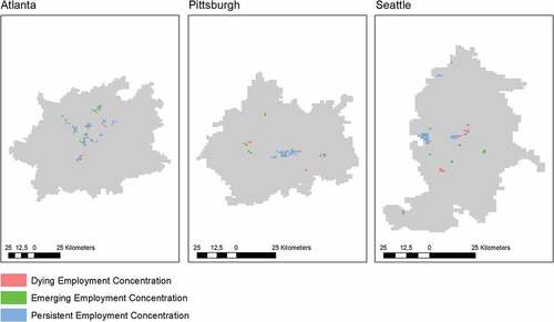
Figure 2. Employment concentrations in German city regions 2002, 2015. Notes: Delineation of case study regions based on 60-minute travel time isochrones (Berlin, Hamburg) or 45 minutes (Nuremberg), given a free-flow road network. Source: Own calculations.
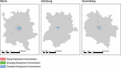
The spatial patterns of the U.S. case study employment centers are quite heterogenous. Atlanta appears to be the most polycentric, without a significant major center identified via visual inspection. Many of its detected employment concentrations resemble corridors along major transport arteries. By contrast, employment concentrations in Pittsburgh and Seattle are more compact with a single dominating core. Furthermore, we find that the changes in spatial patterns are more dynamic in the U.S. than in Germany. While we found several “dying” employment concentrations in the German case study regions, we found only few emerging employment centers on the urban periphery. The most striking difference between the U.S. and German case study regions is that persistence scores measuring the spatial persistence of employment concentrations are distinctly higher in Germany (see ). This might be explained by the fact that German core cities have maintained their relative business attractiveness and/or that stricter land regulations in Germany have had a restrictive effect on the spatial growth of employment concentrations.
Table 2. Descriptive statistics of employment concentrations in U.S. and German city regions 2002, 2015.
Otherwise, we did not find significant static or dynamic characteristics of employment concentrations discernible as specific to the U.S. or German case studies. The number of concentrations within individual city regions in the U.S. ranges from nine in Pittsburgh (2002) to 31 in Atlanta (2002), and in Germany from 11 (Berlin, 2015) to 17 (Nuremberg, 2002 and 2017). Within most case study regions, we did not find great changes in the number of concentrations. The most significant changes were in Pittsburgh where the number of concentrations increased from nine to 12, and in Berlin where the number decreased from 15 to 11.
In all case study regions, we found significant changes in the average size (area and number of employees) as well as in the density of employment concentrations. In all German case study regions and in Seattle, the number of employees per center increased from 2002 to 2015. By contrast, decreasing numbers of employees per center and densities between 2002 and 2015 were found in Pittsburgh. Atlanta only had minor changes. We interpret these findings as evidence of the impact of stricter growth management policies in Germany and Washington state, leading urban employment growth to be concentrated in designated urban core areas and subcenters. Moreover, Seattle’s employment concentrations have by far the highest observed average densities (14,459 employees per km2 in 2002 and 15,151 in 2015). The fragmented geography and the relative land scarcity in the region could explain this finding.
shows the degree of morphological polycentricity within the case study regions. The most significant difference between the U.S. and German regions is that the urban primacy index is distinctly higher in the latter ones, pointing to the persisting dominance of core cities in Germany. Changes in the primacy index varied strongly among the case study regions and even within both countries, increasing significantly in Berlin (+0.08), moderately in Seattle (+0.016), remaining relatively stable in Atlanta and Hamburg, and significantly decreasing in Pittsburgh (−0.09) and Nuremberg (−0.102).Footnote6
Table 3. Size distribution of employment concentrations in U.S. and German city regions 2002, 2015.
We also found country-specific differences regarding the rank-size coefficient and the polycentricity index by Green (Citation2007). The rank-size coefficient ranged from −1.009 in Atlanta (2015) to −2.565 in Berlin (2015), with the larger German city regions featuring distinctly steeper rank-size distributions than their American counterparts. By contrast, the rank-size coefficient in Pittsburgh (−1.883 in 2015) was slightly steeper than in Nuremberg (−1.779 in 2015). The coefficient became significantly steeper in Berlin (−0.255), indicating a development toward monocentricity. We find evidence for a polycentric development in Pittsburgh (+0.201) and Nuremberg (+0.124), two cities where the rank-size coefficient had become flatter. In Atlanta, Seattle and Hamburg, we observe just small changes in the rank-size coefficient, with the Green index ranging from 0.348 in Berlin (2015) to 0.547 in Atlanta (2002). In general, the balance between the size of employment centers is distinctly higher in U.S. than in German city regions. In most cases we observe only minor changes between 2002 and 2015.
Changes in the spatial distribution of employment across sectors—monocentric, polycentric or dispersed?
Alongside the analyses of employment concentrations and their spatial structure discussed above, our data enabled us to compare the development of the spatial distribution of employment across different economic sectors. (U.S.) and (Germany) show results which differentiate between core city employment, subcenter employment and dispersed employment. The breakdown of total and sectoral employment across these spatial categories to some degree resembles the results presented above.
Figure 3. Spatial distribution of employment in U.S. city regions 2002, 2015. Source: Own calculations based on United States Census Bureau (2020).
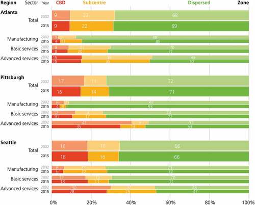
Figure 4. Spatial distribution of employment in German city regions 2002, 2015. Source: Own calculations based on Institut für Arbeitsmarkt und Berufsforschung (2020).
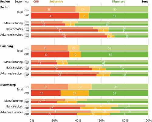
Our results show that core cities play a much larger role in the German city regions, with only small shares of total metropolitan employment concentrated in subcenters. In addition, the ratio of dispersed employment is generally higher within the U.S. metropolitan areas, where at least two-thirds of total metropolitan employment is located outside the detected employment concentrations. In all our case study regions, dispersed employment constitutes more than 50% of total metropolitan employment.Footnote7 We also observed increasing subcenter employment shares in Pittsburgh (+3% of total employment) and Nuremberg (+4%) and an increasing core city employment share in Berlin (+3%), while the spatial distribution remained stable in the remaining regions.
As expected, we found significant differences between sectors. The manufacturing sector was the most dispersed, whereas advanced services were very much concentrated in the core city and/or subcenters. We found the highest share of dispersed manufacturing employment in Pittsburgh (93% in 2015) and the lowest in Nuremberg (53% in 2002). Conversely, the share of dispersed employment in advanced services was 53% in Pittsburgh (2015) and 24% in Nuremberg (2002). The employment development trends across the individual sectors were mostly in line with total employment trends. However, we found that decreasing core city employment shares in the manufacturing sector (in Pittsburgh and Nuremberg) were strongly linked to general employment dispersal, whereas decreasing core city employment shares in the advanced services sector contributed to increasing employment shares in subcenters. Surprisingly, while employment concentrations were spatially more persistent in the German case study regions, we found that the redistribution of employment across the three different spatial categories was much more dynamic in Germany than in the U.S. Particularly, the ratio of dispersed employment remained remarkably stable across all observed sectors in the U.S. city regions under analysis.
Discussion
In this paper, we compare intra-urban employment geographies across city regions in Germany and the U.S., to identify systematic differences in the urban spatial structure between both countries. Our analysis of employment concentrations across three U.S. and three German metropolitan areas reveals major differences between the two countries, but also significant differences within each country. In the German cases, core cities play a far more dominant role for the spatial distribution of employment than in the U.S. Hence, we conclude that German city regions continue to be distinctly more monocentric than their U.S. counterparts. This is consistent with the findings of previous studies on employment subcenters in European city regions (Bontje & Burdack, Citation2005; Guillain et al., Citation2006; Krehl, Citation2018; Krehl & Siedentop, Citation2018; Riguelle et al., Citation2007), which state that European-style subcenters tend to complement rather than rival traditional core cities. However, in both countries, larger shares of metropolitan employment are dispersed rather than concentrated in centers.
Further, we analyze changes in urban employment geographies during the beginning of the 21st century, a period of strong demographic re-urbanization across many city regions of the Global North. This was carried out in order to understand if the prevalent trend of employment suburbanization observed throughout the second half of the 20th century is continuing, or whether there is a new trend toward recentralization. Thereby, we intend to identify if there is a convergent trend across city regions in the U.S. and Germany, or if the development of the intra-urban employment geographies is highly case-specific.
While the areas identified as employment concentrations were more persistent in Germany, the intra-metropolitan re-distribution of employment between the core city, employment subcenters and areas not identified as employment concentrations was surprisingly stronger within the German city regions. Comparing changes in employment concentrations across the individual regions, we did not find common or country-specific trends. In three of our six case study areas, there are only minor changes in the general urban spatial structure. In the two smaller case study regions, Pittsburgh and Nuremberg, we found a relatively significant trend toward polycentric development. Both regions went through a phase of economic restructuring. Conversely, employment subcenters in Berlin have lost importance, pointing to monocentric development driven by locational preferences of advanced service industries.
These changes should be interpreted with reference to the initial spatial structure and the historical and geographical conditions of the observed regions (Bartosiewicz & Marcinczak, Citation2022). The two smaller case study regions showing a significant trend toward increased polycentricity have historically always been polycentric to a certain degree.Footnote8 Thus, one could argue that the trajectories of urban spatial structure are path-dependent and mirror the historical structure of the region in question (also see Giuliano et al., Citation2022). On the other hand, in all case study regions we also find significant changes in the spatial location of employment concentrations with a significant number of dying and emerging centers, indicating that employment centers are less stable than found in previous longitudinal studies (also see, Kane et al., Citation2018).
Our results are in line with previous studies, highlighting very heterogenous developments in the intra-metropolitan concentration of employment (Bartosiewicz & Marcinczak, Citation2022; Burger et al., Citation2011; Heider & Siedentop, Citation2020; Lee, Citation2007; Shearmur & Coffey, Citation2002). Based on our case studies, we thus reject the hypothesis of a single model of employment suburbanization. Instead, changes in employment concentrations and metropolitan spatial structures seem to be driven by a complex interplay of geographical and historical conditions, structural change and economic development, as well as national and regional planning policies.
Regarding the interpretation of the changes discussed above, we need to point out one important caveat. The global financial crisis which occurred in 2008–2009 had a strong impact on employment development around the world. This could also have altered the trajectories of intra-urban employment concentration. According to Heider and Siedentop (Citation2020), the crisis led to a temporary increase in the concentration of economic activity in U.S. metropolitan areas between 2007 and 2011 due to more job losses in the urban periphery than in core cities. In Germany, the authors did not find any significant effect of the financial crisis on employment suburbanization. With regard to our results, this implies that the relatively modest de-concentration observed across our U.S. case study regions might have been influenced by the economic crisis. It is beyond the scope of this paper to isolate these effects. However, we must acknowledge that country-specific trajectories of intra-urban employment geographies are not only the result of different planning policies and varying historical and geographical conditions, but also may have been caused by the varying impact of the economic crisis.
From a methodological point of view, our analyses allow a more precise and systematic comparison of metropolitan areas than previous international comparative studies of employment concentration, which were either qualitative (Bontje & Burdack, Citation2005) or based on coarse units of spatial aggregation (Heider & Siedentop, Citation2020). Our results support the claim that the granularity of input data as well as the method used to identify centers has strong implications on the validity of results (Bartosiewicz & Marcińczak, Citation2020). For example, our maps of employment concentrations in the Pittsburgh area (see, ) distinctly differ from the results presented in Buckwalter (Citation2021), who used census block groups and density thresholds to identify employment centers. Studies of polycentricity based on none-too-fine administrative territorial units might not be able to accurately identify employment concentrations, potentially resulting in misleading conclusions. Especially for comparative studies of intra-urban polycentricity, it is therefore necessary to use fine-grained spatial data that are not biased by administrative borders.
Conclusions
Our empirical results highlight strong transnational differences in the spatial distribution of metropolitan employment beyond the presence of varying natural geographical conditions. Based on our findings, we argue that concepts such as “edge cities” or “edgeless cities” can hardly be transferred to the German context, as German metropolitan areas are distinctly less polycentric and dispersed than their U.S. counterparts. Moreover, German subcenters are generally smaller in size and show a different location pattern. We therefore reject the hypothesis of a convergent change of urban spatial structure in the U.S. and Germany. Instead, we find a large variety of changes in the spatial distribution of employment across our case study regions. Hence, the de-concentration and decentralization of economic activity and polycentric development cannot be understood as universal phenomena. Rather, they should be considered as processes very much dependent on local conditions such as physical geography, historical settlement patterns, planning institutions, and planning policies.
Obviously, our case study sample is by no means representative of all city regions in the U.S. or Germany. Indeed, it would be interesting to compare our results with findings from countries in the developing world featuring completely different economic and institutional conditions. We argue for more international comparative research on the evolution of metropolitan structures. International comparisons of metropolitan employment patterns covering more countries and city regions would permit researchers to distinguish more clearly between what is generalizable and what is specific and context-bound.
Acknowledgments
We thank Christian Gerten for calculating the travel time isochrones for the delineation of the case study areas, Jutta Rönsch for her graphical assistance and Alistair Dunlop for proofreading. We also thank Katrin Anacker as well as three anonymous reviewers for their careful reading of our manuscript and their many insightful comments and suggestions. Last but not least, we gratefully acknowledge financial support for our research by the German Research Foundation (DFG).
Disclosure statement
No potential conflict of interest was reported by the author(s).
Additional information
Funding
Notes on contributors
Bastian Heider
Bastian Heider is a postdoctoral researcher and the deputy head of the “Geoinformation and Monitoring” unit at the Research Institute for Regional and Urban Development (ILS), Dortmund, Germany. He received the diploma in geography from the Leibniz University of Hannover in 2014 and the doctoral degree (Dr. rer. Pol.) in economics from the Martin Luther University of Halle-Wittenberg in 2019. His research focuses on the analysis of urban spatial structure, the evolution of urban systems, as well as applied spatial econometrics and statistics.
Johannes Mast
Johannes Mast is a PhD student at the German Remote Sensing Data Center (DFD) of the German Aerospace Center (DLR), Weßling, Germany. He received the BSc degree in geography from the Leibniz University Hannover, Germany, in 2018, and the MSc degree in applied remote sensing from the Julius-Maximilians-University, Würzburg, Germany, in 2021. His research interest is the joint use of remote sensing and text data in the study of migration processes and urban environments.
Duncan Roth
Duncan Roth is the head of the junior research group “Occupations and Employment Trajectories” at the Institute for Employment Research (IAB), Nuremberg, Germany, and senior researcher at the Regional Research Network of the IAB. Following a Bachelor degree in politics, philosophy and economics from the University of York, he completed a Master of Science program in economics at the University of Warwick. He obtained his doctorate at Philipps-Universität Marburg on the topic of “Cohort size and labor-market outcomes.” His research interests lie in the field of empirical labor economics.
Ines Standfuß
Ines Standfuß is a PhD student at the German Remote Sensing Data Center (DFD) of the German Aerospace Center (DLR), Weßling, Germany. She received the Diploma (Dipl.-Ing.) in spatial planning from the Technical University of Dortmund in 2012, and the Master of Science degree in geography with a focus on geomatics from Ruhr-University Bochum in 2015. Her current research interests include urban and environmental remote sensing topics and the application of remote sensing information products in urban and ecological analysis.
Stefan Siedentop
Stefan Siedentop is a Full Professor of Spatial Planning at the Technical University of Dortmund and Managing Director of Research in the ILS-Institute for Regional and Urban Development (ILS). He graduated in spatial planning at the University Dortmund and started his academic career as a research assistant and project manager at the Leibniz-Institute of Environmental and Regional Development (IÖR) in Dresden. In 2007, Stefan Siedentop was appointed as a Full Professor of Spatial and Environmental Planning in the Institute of Regional Development Planning, University of Stuttgart. He headed the institute until 2012 before taking up his current position in Dortmund. His research interest cover issues of structural urban change and urban growth management.
Hannes Taubenböck
Hannes Taubenböck is the head of the department “Geo-Risks and Civil Security” at the German Remote Sensing Data Center (DFD) of the German Aerospace Center(DLR), Weßling, Germany. He received the Diploma in geography from the Ludwig-Maximilians Universität München in 2004, and the doctoral degree (Dr. rer. nat.) in geography from the Julius Maximilian’s University of Würzburg in 2008. In 2019, he habilitated at the University of Würzburg in Geography. His current research interests include urban remote sensing topics, from the development of algorithms for information extraction to value adding to classification products for findings in urban geography.
Notes
1. Census blocks are bounded by visible features such as roads, streams, and railroad tracks, and by nonvisible boundaries such as property lines, city, township, school district, and county limits and can vary in size (Rossiter, Citation2011). In some rural unpopulated or scarcely populated areas census tracts are distinctly larger than 1 km². This might lead to a loss of precision when the 1 km × 1 km grid is superimposed on the census blocks.
2. The address provided in the data may not refer to an establishment’s actual location. If a firm consists of different establishments which are located in the same municipality and are assigned to the same sector of economic activity, each establishment may be registered under a common address even if they are located in different places.
3. Manufacturing refers to sectors 22–23 and 31–33 under the American NAICS classification, and C-F under the German classification (WZ 2008). Basic services refer to NAICS sectors 42–49 and 61–92, and to the German G-I and N-S sectors. Advanced services refer to NAICS sectors 51–55, and to the German J-M sectors.
4. Similar concepts of metropolitan areas in Germany are the Stadt-Land-Regionen (SLR), defined by the Federal Institute for Research on Building, Urban Affairs and Spatial Development (BBSR), or the Arbeitsmarktregionen defined by the Federal Employment Agency. However, the resulting spatial units differ significantly from CBSAs and are therefore not directly comparable.
5. The region’s center is defined as the geographic center of the region defined in Open Street Map.
6. The decrease in Nuremberg’s primacy index was partially caused by the fragmentation of the urban core discussed above.
7. The only exception is Nuremberg in 2002, where dispersed employment made up just 48% of total metropolitan employment.
8. Although Pittsburgh was the least polycentric case study region in the U.S. at the starting point of our study.
References
- Agarwal, A. (2015). An examination of the determinants of employment center growth: Do local policies play a role? Journal of Urban Affairs, 37(2), 192–206. https://doi.org/10.1111/juaf.12097
- Anas, A., Arnott, R., & Small, K. A. (1998). Urban spatial structure. Journal of Economic Literature, 36(3), 1426–1464.
- Arribas-Bel, D., & Sanz-Gracia, F. (2014). The validity of the monocentric city model in a polycentric age: US metropolitan areas in 1990, 2000 and 2010. Urban Geography, 35(7), 980–997. https://doi.org/10.1080/02723638.2014.940693
- Bae, C.-H. C., & Richardson, H. W. (2004). Urban sprawl in Western Europe and the United States. Routledge. https://doi.org/10.4324/9781315235226
- Bartosiewicz, B., & Marcinczak, S. (2022). Urban structure in transition: Evidence from Poland, 1983–2011. Regional Studies, 56(1), 36–47. https://doi.org/10.1080/00343404.2021.1878125
- Bartosiewicz, B., & Marcińczak, S. (2020). Investigating polycentric urban regions: Different measures—different results. Cities, 105, Article 102855. https://doi.org/10.1016/j.cities.2020.102855
- Bontje, M., & Burdack, J. (2005). Edge cities, European-style: Examples from Paris and the Randstad. Cities, 22(4), 317–330. https://doi.org/10.1016/j.cities.2005.01.007
- Bourne, L. S. (2008). On schools of thought, comparative research, and inclusiveness: A commentary. Urban Geography, 29(2), 177–186. https://doi.org/10.2747/0272-3638.29.2.177
- Brookings Institution Center on Urban and Metropolitan Policy. (2000). Moving beyond sprawl. The challenge for metropolitan Atlanta. Washington D.C: Brookings Institution.
- Buckwalter, D. (2021). Changing employment subcenters and opportunity in the Pittsburgh metropolitan area. Journal of Urban Affairs, 1–18. Advance online publication. https://doi.org/10.1080/07352166.2021.1933506
- Burger, M. J., de Goei, B., van der Laan, L., & Huisman, F. J. (2011). Heterogeneous development of metropolitan spatial structure: Evidence from commuting patterns in English and Welsh city regions, 1981–2001. Cities, 28(2), 160–170. https://doi.org/10.1016/j.cities.2010.11.006
- Burger, M., & Meijers, E. (2012). Form follows function? Linking morphological and functional polycentricity. Urban Studies, 49(5), 1127–1149. https://doi.org/10.1177/0042098011407095
- Carruthers, J. I. (2002). The impacts of state growth management programmes: A comparative analysis. Urban Studies, 39(11), 1959–1982. https://doi.org/10.1080/0042098022000011317
- Core Values. (2015). Why American companies are moving downtown. Smart Growth America. https://smartgrowthamerica.org/app/legacy/documents/core-values.pdf
- Dembski, S., Sykes, O., Couch, C., Desjardins, X., Evers, D., Osterhage, F., Siedentop, S., & Zimmermanne, K. (2021). Reurbanisation and suburbia in Northwest Europe: A comparative perspective on spatial trends and policy approaches. Progress in Planning, 150, Article 102855. https://doi.org/10.1016/j.progress.2019.100462
- Derudder, B., Liu, X., Wang, M., Zhang, W., Wu, K., & Caset, F. (2021). Measuring polycentric urban development: The importance of accurately determining the ‘balance’ between ‘centers.’ Cities, 111, Article 103009. https://doi.org/10.1016/j.cities.2020.103009
- Dielemann, F., & Wegener, M. (2004). Compact city and urban sprawl. Built Environment, 30(4), 308–323. https://doi.org/10.2148/benv.30.4.308.57151
- Dijst, M., & Vázquez, C. (2007). Employment deconcentration in European metropolitan areas: A comprehensive comparison and policy implications. In E. Razin, M. Dijst, & C. Vázquez (Eds.), Employment deconcentration in European metropolitan areas: Market forces versus planning regulations (pp. 265–292). Springer.
- Dörre, K., & Röttger, B. (2006). Altindustrielle Regionen im radikalen Strukturwandel. In K. Dörre & B. Röttger (Eds.), Im Schatten der Globalisierung: Strukturpolitik, Netzwerke und Gewerkschaften in altindustriellen Regionen (pp. 31–61). VS Verlag für Sozialwissenschaften. https://doi.org/10.1007/978-3-531-90360-6_2
- Duvivier, C., Polèse, M., & Apparicio, P. (2018). The location of information technology-led new economy jobs in cities: Office parks or cool neighbourhoods? Regional Studies, 52(6), 756–767. https://doi.org/10.1080/00343404.2017.1322686
- The Economist. (2020). How Berlin has become a centre for European venture capital. https://www.economist.com/finance-and-economics/2020/10/22/how-berlin-has-become-a-centre-for-european-venture-capital
- Florida, R. L. (2002). The rise of the creative class: And how it’s transforming work, leisure, community and everyday life. Basic Books.
- Friedman, T. L. (2005). The world is flat: A brief history of the twenty-first century. Farrar, Straus and Giroux.
- Ganzer, A., Schmidtlein, L., Stegmaier, J., & Wolter, S. (2021). Establishment history panel 1975-2019 * revised version (v2). Institute for Employment Research. https://doi.org/10.5164/IAB.FDZD.2016.en.v2
- Garreau, J. (1991). Edge city: Life on the new frontier. Doubleday.
- Giuliano, G., Hou, Y., Kang, S., & Shin, E. J. (2022). Polycentricity and the evolution of metropolitan spatial structure. Growth and Change, 53(2), 593–627. https://doi.org/10.1111/grow.12599
- Giuliano, G., Redfearn, C., Agarwal, A., & He, S. (2011). Network accessibility and employment centres. Urban Studies, 49(1), 77–95. https://doi.org/10.1177/0042098011411948
- Giuliano, G., & Small, K. A. (1991). Subcenters in the Los Angeles region. Regional Science and Urban Economics, 21(2), 163–182. https://doi.org/10.1016/0166-0462(91)90032-I
- Glaeser, E. L., & Gottlieb, J. D. (2006). Urban resurgence and the consumer city. Urban Studies, 43(8), 1275–1299. https://doi.org/10.1080/00420980600775683
- Gleeson, R. E., & Paytas, J. (2005). Pittsburgh: Economic restructuring and regional development patterns, 1880–2000. In J. R. Pack (Ed.), Sunbelt/Frostbelt: Public policies and market forces in metropolitan development (pp. 182–218). Brookings Institution Press.
- Gordon, P., & Cox, W. (2012). Cities in Western Europe and the United States: Do policy differences matter? The Annals of Regional Science, 48(2), 565–594. https://doi.org/10.1007/s00168-011-0495-8
- Gordon, P., & Richardson, H. W. (1996). Beyond polycentricity: The dispersed metropolis, Los Angeles, 1970-1990. Journal of the American Planning Association, 62(3), 289–295. https://doi.org/10.1080/01944369608975695
- Görlinger, M., Stiller, S., & Sünner, I. (2013). Ökonomische Eckdaten und wirtschaftsstrukturelle Entwicklung in der Metropolregion Hamburg. Hamburgisches WeltWirtschaftsInstitut.
- Graham, M. R., Kutzbach, M. J., & McKenzie, B. (2014). Design comparison of LODES and ACS commuting data products (Working Paper CES-WP14-38). Center for Economic Studies, U.S. Census Bureau.
- Green, N. (2007). Functional polycentricity: A formal definition in terms of social network analysis. Urban Studies, 44(11), 2077–2103. https://doi.org/10.1080/00420980701518941
- Guillain, R., Le Gallo, J., & Boiteux-Orain, C. (2006). Changes in spatial and sectoral patterns of employment in Ile-de-France, 1978-97. Urban Studies, 43(11), 2075–2098. https://doi.org/10.1080/00420980600945203
- Haase, A., Bontje, M., Couch, C., Marcinczak, S., Rink, D., Rumpel, P., & Wolff, M. (2020). Factors driving the regrowth of European cities and the role of local and contextual impacts: A contrasting analysis of regrowing and shrinking cities. Cities, 108. Article 102942. https://doi.org/10.1016/j.cities.2020.102942
- Hajrasouliha, A. H., & Hamidi, S. (2017). The typology of the American metropolis: Monocentricity, polycentricity, or generalized dispersion? Urban Geography, 38(3), 420–444. https://doi.org/10.1080/02723638.2016.1165386
- Hartley, D. A., Kaza, N., & Lester, T. W. (2015). Are America’s inner cities competitive? Evidence from the 2000s. Economic Development Quarterly, 30(2), 137–158. https://doi.org/10.1177/0891242416638932
- Heider, B., & Siedentop, S. (2020). Employment suburbanization in the 21st century: A comparison of German and US city regions. Cities, 104, 102802. Article 102802. https://doi.org/10.1016/j.cities.2020.102802
- Hyra, D. S. (2015). The back-to-the-city movement: Neighbourhood redevelopment and processes of political and cultural displacement. Urban Studies, 52(10), 1753–1773. https://doi.org/10.1177/0042098014539403
- Kane, K., Hipp, J. R., & Kim, J. H. (2018). Los Angeles employment concentration in the 21st century. Urban Studies, 55(4), 844–869. https://doi.org/10.1177/0042098016678341
- Kantor, P., & Savitch, H. V. (2005). How to study comparative urban development politics: A research note. International Journal of Urban and Regional Research, 29(1), 135–151. https://doi.org/10.1111/j.1468-2427.2005.00575.x
- Kloosterman, R. C., & Musterd, S. (2001). The polycentric urban region: Towards a research agenda. Urban Studies, 38(4), 623–633. https://doi.org/10.1080/2F00420980120035259
- Krehl, A. (2018). Urban subcentres in German city regions: Identification, understanding, comparison. Papers in Regional Science, 97(1), 79–104. https://doi.org/10.1111/pirs.12235
- Krehl, A., & Siedentop, S. (2018). Towards a typology of urban centers and subcenters—Evidence from German city regions. Urban Geography, 40(1), 58–82. https://doi.org/10.1080/02723683.2018.15002545
- Lang, R. E., & LeFurgy, J. (2003). Edgeless cities: Examining the noncentered metropolis. Housing Policy Debate, 14(3), 427–460. https://doi.org/10.1080/10511482.2003.9521482
- Larsson, J. P. (2017). Non-routine activities and the within-city geography of jobs. Urban Studies, 54(8), 1808–1833. https://doi.org/10.1177/0042098016643266
- Lee, B. (2007). “Edge” or “edgeless” cities? Urban spatial structure in U.S. metropolitan areas, 1980 to 2000. Journal of Regional Science, 47(3), 479–515. https://doi.org/10.1111/j.1467-9787.2007.00517.x
- Liu, X., Pan, Q., King, L., & Jin, Z. (2019). Analysing the changes of employment subcentres: A comparison study of Houston and Dallas. Urban Studies, 56(12), 2532–2548. https://doi.org/10.1177/0042098018789554
- McMillen, D. P. (2001). Nonparametric employment subcenter identification. Journal of Urban Economics, 50(3), 448–473. https://doi.org/10.1006/juec.2001.2228
- McMillen, D. P. (2003). Identifying sub-centres using contiguity matrices. Urban Studies, 40(1), 57–69. https://doi.org/10.1080/00420980220080161
- McMillen, D. P. (2004). Employment densities, spatial autocorrelation, and subcenters in large metropolitan areas. Journal of Regional Science, 44(2), 225–244. https://doi.org/10.1111/j.0022-4146.2004.00335.x
- Muñiz, I., & Garcia-López, M.-À. (2010). The polycentric knowledge economy in Barcelona. Urban Geography, 31(6), 774–799. https://doi.org/10.2747/0272-3638.31.6.774
- Münter, A., & Volgmann, K. (2021). Polycentric regions: Proposals for a new typology and terminology. Urban Studies, 58(4), 677–695. https://doi.org/10.1177/0042098020931695
- Negroponte, N. (1995). Being digital. Hodder and Stoughton.
- Nelson, A. C. (1999). Comparing states with and without growth management. Analysis based on indicators with policy implications. Land Use Policy, 16(2), 121–127. https://doi.org/10.1016/S0264-8377(99)00009-5
- Nichols Clark, T., Lloyd, R., Wong, K. K., & Jain, P. (2002). Amenities drive urban growth. Journal of Urban Affairs, 24(5), 493–515. https://doi.org/10.1111/1467-9906.00134
- Pickvance, C. (2001). The four varieties of comparative analysis: The case of environmental regulation. Journal of Housing and the Built Environment, 16(1), 7–28. https://doi.org/10.1023/A:1011533211521
- Pierre, J. (2005). Comparative urban governance: Uncovering complex causalities. Urban Affairs Review, 40(4), 446–462. https://doi.org/10.1177/1078087404273442
- Riguelle, F., Thomas, I., & Verhetsel, A. (2007). Measuring urban polycentrism: A European case study and its implications. Journal of Economic Geography, 7(2), 193–215. https://doi.org/10.1093/jeg/lbl025
- Robinson, L., Newell, J. P., & Marzluff, J. M. (2005). Twenty-five years of sprawl in the Seattle region: Growth management responses and implications for conservation. Landscape and Urban Planning, 71(1), 51–72. https://doi.org/10.1016/j.landurbplan.2004.02.005
- Rossiter, K. (2011). What are census blocks? United States Census Bureau. https://www.census.gov/newsroom/blogs/random-samplings/2011/07/what-are-census-blocks.html
- Schmidt, S. (2013). Sprawl without growth in Eastern Germany. Urban Geography, 32(1), 105–128. https://doi.org/10.2747/0272-3638.32.1.105
- Schmidt, S., & Buehler, R. (2007). The planning process in the US and Germany: A comparative analysis. International Planning Studies, 12(1), 55–75. https://doi.org/10.1080/13563470701346592
- Schmidt, S., Li, W., Carruthers, J. I., & Siedentop, S. (2021). Planning institutions and urban spatial patterns: Evidence from a cross-national analysis. Journal of Planning Education and Research, 0739456X2110442. Advance online publication. https://doi.org/10.1177/0739456X211044203
- Schmidt, S., Siedentop, S., & Fina, S. (2017). How effective are regions in determining urban spatial patterns? Evidence from Germany. Journal of Urban Affairs, 40(5), 639–656. https://doi.org/10.1080/07352166.2017.1360741
- Scott, A. J. (1988). Flexible production systems and regional development: The rise of new industrial spaces in North America and Western Europe. International Journal of Urban and Regional Research, 12(2), 171–186. https://doi.org/10.1111/j.1468-2427.1988.tb00448.x
- Shearmur, R. (2012). The geography of intrametropolitan KIBS innovation: Distinguishing agglomeration economies from innovation dynamics. Urban Studies, 49(11), 2331–2356. https://doi.org/10.1177/0042098011431281
- Shearmur, R., & Alvergne, C. (2003). Regional planning policy and the location of employment in the Ile-De-France. Urban Affairs Review, 39(1), 3–31. https://doi.org/10.1177/1078087403253557
- Shearmur, R., & Coffey, W. J. (2002). A tale of four cities: Intrametropolitan employment distribution in Toronto, Montreal, Vancouver, and Ottawa - Hull, 1981 - 1996. Environment and Planning A: Economy and Space, 34(4), 575–598. https://doi.org/10.1068/a33214
- Siedentop, S., & Pehlke, D. (2021). Die Regulierungsintensität der regionalen Planung zur Steuerung der Wohnsiedlungsentwicklung: Eine Planinhaltsanalyse der deutschen Raumordnungspläne und der schweizerischen Kantonalen Richtppläne (ILS Working Paper). ILS − Institut für Landes- und Stadtentwicklungsforschung gGmbH.
- Spencer, G. M. (2015). Knowledge neighbourhoods: Urban form and evolutionary economic geography. Regional Studies, 49(5), 883–898. https://doi.org/10.1080/00343404.2015.1019846
- Sun, T. (2020). A longitudinal study of changes in intra-metropolitan employment concentration in Beijing: Decentralisation, reconcentration and polycentrification. Urban Studies, 57(4), 748–765. https://doi.org/10.1177/0042098019861382
- van Meeteren, M., Poorthuis, A., Derudder, B., & Witlox, F. (2016). Pacifying Babel’s Tower: A scientometric analysis of polycentricity in urban research. Urban Studies, 53(6), 1278–1298. https://doi.org/10.1177/0042098015573455
- Volgmann, K., & Münter, A. (2018). Specialization of and complementarities between (new) knowledge clusters in the Frankfurt/Rhine-Main urban region. Regional Studies, Regional Science, 5(1), 125–148. https://doi.org/10.1080/21681376.2018.1452630
- Zhang, W., & Derudder, B. (2019). How sensitive are measures of polycentricity to the choice of ‘centres’? A methodological and empirical exploration. Urban Studies, 56(16), 3339–3357. https://doi.org/10.1177/0042098019843061