Abstract
Severson, J.P., J.R. Nawrot and M.W. Eichholz. 2009. Shoreline stabilization using riprap breakwaters on a Midwestern reservoir. Lake Reserv. Manage. 25:208–216.
Shoreline erosion causes shoreline habitat loss and degradation and contributes to sedimentation, a major impairment in many lakes throughout the United States. Various shoreline stabilization techniques have been employed, but many are unsuccessful under high wave stress, do not contribute to shoreline habitat, or are too expensive to install on a large scale. Extensive erosion and lack of shoreline habitat on Kinkaid Lake in southern Illinois prompted lake managers to design and install riprap breakwaters to protect the littoral zone and bank as well as enhance habitat. The offshore breakwaters were shown to decrease wave height and associated erosion, allowing banks to start stabilizing and the protected littoral zone to begin sequestering sediment. Terrestrial area inside the protected zones was regressed against age since protection, bank height, and distance from bank to produce a terrestrialization predictive model. Vegetation richness was much greater at protected sites than unprotected sites, and vegetation cover increased with age since protection. The riprap breakwaters were successful at bank stabilization and habitat enhancement and should therefore be considered for use where these attributes are desired.
Reservoirs are important resources for recreation, water supply, flood control, and wildlife habitat, but these benefits are impacted by water quality degradation (CitationIEPA 1978a, Citation2002). Suspended sediment and siltation are significant impairments to reservoirs in the Midwest and throughout the United States (CitationIEPA 2002, CitationUSEPA 2002). They contribute to water quality degradation and water storage reduction, which affects recreational opportunities and increases water treatment costs (CitationIEPA 1978a, CitationHoldren et al. 2001). Flora and fauna are also affected. Suspended sediment can cause vegetation (CitationJackson and Starrett 1959, CitationRobel 1961) and animals (CitationKarr et al. 1985, CitationCuker 1993, CitationBox and Mossa 1999, CitationBolen and Robinson 2003) to shift in community composition and structure as well as decline in population and diversity due to a decreased photic zone, altered water chemistry, and physical effects on respiration, foraging, and reproduction. Sedimentation can result in unstable substrates for vegetation and invertebrates, homogenize the substrate habitat, and supply an easily suspended sediment source that can affect various biotic communities (CitationPeters 1967, CitationBellrose et al. 1979, CitationCuker 1993, CitationCummins and Merritt 1996, CitationAngradi 1999, CitationBox and Mossa 1999, CitationZweig and Rabeni 2001, CitationBolen and Robinson 2003). Recently, many agencies have attempted to address the problems associated with suspended and deposited sediment.
A major source of sediment in some reservoirs is shoreline erosion (CitationWindorn 2000). Not only does erosion contribute to lake filling and degraded water quality, but it also reduces suitability of shoreline habitat for vegetation and wildlife and causes losses of upland habitat (CitationGersbacher 1937, CitationKeddy 1983). Although the shallow aquatic zones may produce habitat for some species, wave energy limits density, diversity, and distribution of aquatic vegetation on unprotected shorelines (CitationHankla 1952, CitationKolar 1978, CitationKeddy 1983, CitationCollins and Wein 1995, CitationLuken and Bezold 2000), which degrades habitat for fish, invertebrates, and higher trophic levels. Riprap placed directly at the shore–water interface has traditionally been used to reduce erosion but generally does not contribute significantly to floral and faunal habitat. CitationSwales et al. (1986) and CitationGarland et al. (2002) reported decreased fish use at riprap sites while CitationJennings et al. (1999) indicated a possible minor increase in fish diversity at riprap sites. CitationSchmetterling et al. (2001) discussed the potential disadvantages of riprap for fish habitat. Although not studied, most hydrophytic vegetation presumably does not benefit significantly from traditional riprap due to lack of habitat protected from wave energy. Other techniques, such as certain bioengineering methods (e.g., fiber rolls, willow fences, plant rolls), can provide some habitat benefits (e.g., vegetation production, protected littoral zones, limited bank recession) but may not be as suitable as a solid structure under high wave stress. Breakwaters constructed of rock (riprap), however, can be installed offshore to protect the littoral zone from wave stress, providing suitable conditions for a variety of organisms (CitationUSACE 1981, Citation1984, Citation1985, CitationPape 2004).
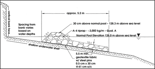
Eroding shorelines form shallow underwater shelves () and vertical bank faces, often with overhangs that slough periodically (Hardaway and Byrne 1999). Breakwaters can be installed on the underwater shelves from the lake with barges to avoid upland disturbance and to protect islands and other areas with limited access (Hank Sutton, Lake Riprap Inc., 2006, pers. comm.). We hypothesized the breakwaters reduce wave energy impacts to the shoreline and near shore littoral zone, potentially improving habitat for a variety of organisms. This study assessed the shoreline stabilization effects of the breakwaters and monitored the vegetation communities in the protected zone.
Figure 1 Breakwater design for Kinkaid Lake produced by the Natural Resources Conservation Service, Murphysboro, Illinois. Breakwater is installed on shallow underwater shelf produced by extensive erosion.
Methods
Study area
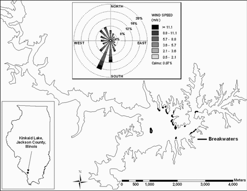
Kinkaid Lake, a 1,113 ha reservoir located in Jackson County in southern Illinois, was constructed in 1969 by damming Kinkaid Creek (). The main body of the lake has a 1,000–1,750-m fetch that can produce large waves in windy weather. Kinkaid Lake is used as the primary water source for several nearby towns and for recreation including water skiing, jet skiing, fishing, and boating. The maximum depth of Kinkaid Lake is 24 m while the average depth of 8.7 m provides a storage capacity of 97 × 106 m3. Land use of the 171 km2 watershed consists of 9% row crop, 23% pasture or hay, 57% forest, and 11% miscellaneous. Land use of the 120 km of shoreline is 1% developed, 10% pasture, and 89% forest. The Kinkaid Lake spillway is positioned at 128 m elevation, but actual lake elevation fluctuates above the spillway during winter and spring and below the spillway during summer (±1 m). In 1978, the annual loss of storage capacity in Kinkaid Lake was 0.04% due to sedimentation (CitationIEPA 1978a, Citation1978b). A 2000 survey indicated ∼0.033% of the lake has filled each year since the lake's construction specifically due to bank erosion (Jackson County Soil and Water Conservation District, unpublished data 2000). Including sedimentation due to runoff and stream load would increase the sediment input estimate. The area soils are highly erodible silt loam and silty clay (CitationHerman 1979), and average annual precipitation is 116.5 cm. Much of Kinkaid Lake's sediment input came from the 9.3 km of severe shoreline erosion and 36.8 km of moderate shoreline erosion identified in the 2000 survey. About 20% of annual sediment input to the lake is from shoreline erosion (Kinkaid Area Watershed Project 2000, CitationWindorn 2000). Bank recession >1 m/yr has been observed in parts of the lake, producing eroded bank heights up to 6 m (David Fligor, Kinkaid Reed's Creek Conservancy District, pers. comm. 2006). To address erosion and lack of shoreline habitat, ∼245 m of limestone aggregate (riprap) breakwater structures were designed and installed on an accessible shoreline by lake managers and local agencies in 1999. In 2001 and 2003, to protect inaccessible shorelines (islands and undeveloped points), specially designed barges were used to install ∼500 m and ∼1,300 m of riprap breakwater structures. In general, breakwaters were installed on the most eroded (highest bank height) shorelines first as determined in the aforementioned 2000 survey. The most eroded shorelines often corresponded with the dominant south–southwest wind direction (). Riprap breakwaters were installed an average of 6.2 m from the bank (min: 2.4 m, max: 12.5 m).
Figure 2 Location of Kinkaid Lake, Jackson County, Illinois and breakwaters present during the study. Wind rose includes 1989–2004 hourly wind data.
Study sites
Wave height measurements were recorded at the most exposed portion (i.e., greatest wave energy; tip of point) of selected breakwater sites of various ages and also at unprotected sites. Intensive erosion, bank, and vegetation surveys were conducted at all sites protected in 1999 and 2001, as well as a selection of the 2003 protected sites due to differences in available breakwaters of different protection age. In all, 73% (1,490 m) of breakwaters on Kinkaid Lake were intensively surveyed. Due to protection of the most degraded shorelines first, representative unprotected sites were limited in availability and accounted for only 20% of all sites surveyed. At each site, transects were developed from bank to breakwater (or toward the lake at unprotected sites) at 8-m intervals along the shoreline, totaling 199 transects (1999 sites = 26 transects; 2001 sites = 55 transects; 2003 sites = 78 transects; unprotected sites = 40 transects). Four survey points were evenly spaced along each transect for a total of 796 survey points, which were used for vegetation quadrat placement.
Wave height
To index wave energy reduction by the breakwaters, wave height ranges were measured with portable gages (stadia rod segment attached to a steel stake) on both shore side and lake side of the breakwaters during three 2-minute intervals at each of six different breakwater sites. Wave height ranges were also measured at two unprotected sites at 4 m and 8 m from the bank. Measurements were recorded in September 2005 during intensive boat traffic conditions. Percent wave height reduction was calculated by dividing inside wave height by outside wave height and subtracting from 1, then multiplying by 100. To compare boat-induced wave to wind-induced waves, estimated wave heights were calculated with formulas from CitationBhowmik (1976) and a program from Wisconsin Department of Natural Resources (WDNR 2008). The Bhowmik formula used 1,600 m fetch length, 1,300 m fetch width, 15.6 m/s wind speed, and 0° wind direction angle relative to lake orientation to calculate significant wave height (the height where one-third of the waves in the profile are greater than this height). The WDNR program used 1,600 m fetch length and 9 m average water depth to calculate storm wave height.
Erosion
Erosion was monitored with an erosion pin installed in the bank at each transect during September 2004. The pins, steel stakes 0.95 cm dia × 91 cm long, were installed horizontally with 15.2 cm exposed at 1.52 m above full pool with bank heights >2 m and 0.61 m above full pool with bank heights <2 m. The pins were monitored June 2005, January 2006, and March 2006, and erosion/accretion was measured.
Bank profile
Bank profiles were measured at each transect to determine stabilization characteristics in the study sites. Bank angle was measured by placing a straight edge and clinometer along the dominant face. The bank lengths were also measured, and trigonometric functions were used to calculate bank height. Accreted sediment depth at the point of measure was determined with a sediment probe and added to bank height to estimate preprotection bank height. Bank profiles were measured in spring 2005.
Protected zone and dry toe width
Distance from breakwater to bank was measured at each transect to index sediment storage capacity during summer–fall 2005. The distance was measured from the water–breakwater interface at full pool to the preprotection eroded bank. The length of the width that was not inundated (at full pool) was also measured to index protected zone terrestrialization.
Vegetation
Vegetation was surveyed to monitor succession in the protected zones and to compare protected and unprotected site vegetation. A 0.25-m2 quadrat was placed over each of the four survey points on each transect. All plant species and an algal genus (Chara spp.) were identified, and their aerial coverage was determined. Ground cover (vegetation, herbaceous litter, woody litter, filamentous algae, rock, and bare soil) were also estimated. Vegetation was monitored October 2004, August 2005, and October 2005.
Data analysis
Wave height reduction between protected and unprotected sites and erosion among the four protection classes were compared using Kruskal-Wallis tests for multiple groups and Wilcoxon tests for paired comparisons (with Dunn-Sidak corrections when necessary) due to heteroscedasdicity in the data. Bank angle and August 2005 vegetation cover data were analyzed by protection class using ANOVA (Analysis of Variance) and Tukey's HSD (Honestly Significant Difference) for multiple comparisons. August 2005 vegetation data were used because mid-summer communities are believed to be the most representative vegetation communities (Matthews et al. Citation2005). Terrestrial transect data were combined for each of the 11 protected sites. The site terrestrial data were then regressed on bank height, age, and breakwater distance from bank using multiple linear regression. The resultant regression model was used to produce a predictive model of protected zone terrestrialization.
Results
Wave height
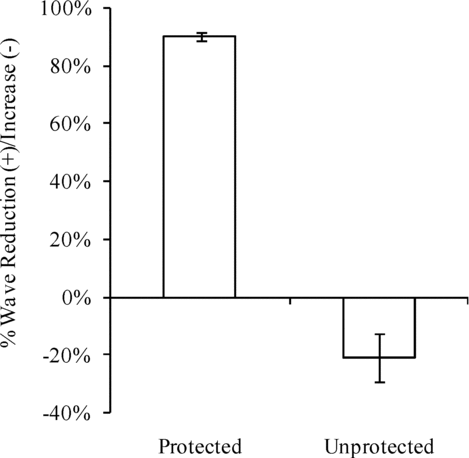
Waves 12–38 cm in height were reduced by an average of 90% upon traveling through the breakwater, while the wave heights increased 21% near shore at unprotected sites (; U = 21.0, df = 20, p = 0.001). The maximum observed wave height within the protected zone was 4.5 cm, while most wave heights were generally 1–2 cm. The Bhowmik formula produced a 48 cm estimated significant wave height; the WDNR program produced a 31 cm estimated storm wave height.
Figure 3 Average wave change (± 1 standard error) through riprap breakwaters (protected) and near shore at unprotected sites. Positive is wave reduction; negative is wave increase.
Erosion
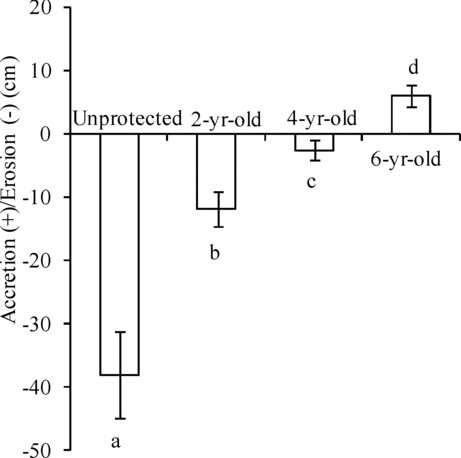
Erosion from September 2004 to March 2006 decreased with age since protection (χ2= 44.673, df = 3, p < 0.001). Average erosion decreased with age: −5.95 cm (6-yr-old protected), 2.51 cm (4-yr-old protected), 11.90 cm (2-yr-old protected), and 38.03 cm (unprotected; ). Average erosion rates throughout the study were 0.32 cm/month (protected) and 2.11 cm/month (unprotected). Average erosion rates were greatest during January–March 2006 (protected: 1.99 cm/month, unprotected 6.03 cm/month). Average erosion rates were lowest from June 2005 to January 2006 (protected: 0.08 cm/month, unprotected: 0.16 cm/month). The maximum erosion rate for one pin was >38 cm/month during January–March 2006 at an unprotected site where the pin was inserted in January and fell out by March. The maximum site average for the entire study period was 8.47 cm/month (1.02 m/yr) at an unprotected site. Average annual erosion (bank recession) at unprotected sites was estimated at 21.0 cm/yr, of which ∼ 59% was estimated to have occurred from mid-January to mid-March.
Figure 4 Average accretion/erosion (± 1 standard error) from September 2004 to March 2006 at unprotected sites and 2- to 6-yr-old breakwater protected sites on Kinkaid Lake.
Bank stabilization and terrestrialization
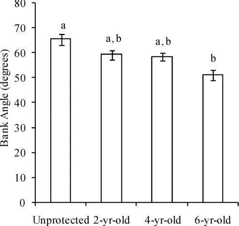
Bank angles decreased with increasing age (F = 5.40, df = 3, 195, p = 0.0014). The oldest sites (6-yr-old) had gentler slopes (51.2°) than the unprotected sites (65.4°). The 2-yr-old (59.3°) and 4-yr-old (58.5°) sites were not significantly different ().
Figure 5 Average bank angles (± 1 standard error) of unprotected sites and 2- to 6-yr-old breakwater protected sites on Kinkaid Lake.
The regression analysis used ages ranging from 2 to 6 years old, bank heights from 0.8 to 5.6 m high, and breakwater distance to bank from 2.4 to 12.5 m. The age, bank height, and breakwater placement regression model was significant (R2= 0.743, F = 6.77, df = 3, 7, p = 0.017; and ):
Figure 6 Predicted terrestrial area (based on bank height, age, and breakwater installation distance using multiple regression) plotted against actual terrestrial area (R2= 0.743, F = 6.77, df = 3,7, p = 0.017).
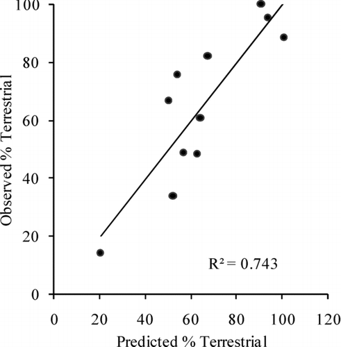
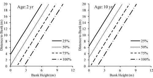
Figure 7 Predictive models of terrestrialization (percent not inundated) in breakwater protected zones. Different line styles represent terrestrial area percentage. Left chart is age = 2 yr prediction. Right chart is age = 10 yr prediction. Models derived from 3-variable (age, bank height, distance to bank) multiple linear regression (R2= 0.743). Data used to produce models: age = 2–6 yr, bank height = 0.8–5.6 m, breakwater placement = 2.4–12.5 m from bank.
Vegetation
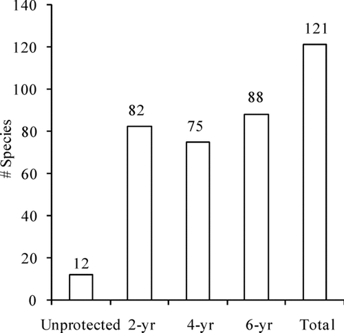
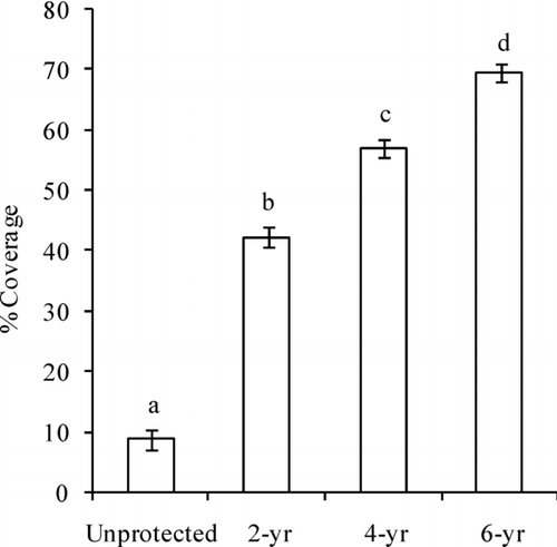
Vegetation observed during the 3 vegetation surveys included 121 species throughout all sites. Combined protected sites included all 121 species, while unprotected sites supported only 12 species (). The 6-yr-old sites had 88, the 4-yr old sites had 75, and the 2-yr-old sites had 82 species (). During the August 2005 survey, vegetation cover showed an increasing trend with age (F = 170.9, df = 3, 793, p < 0.001; ).
Figure 8 Vegetation richness at unprotected sites and each year class of breakwater protected sites on Kinkaid Lake.
Discussion
Wave height reduction by a solid structure is intuitive but is a necessary principle to establish for shoreline stabilization. The small “waves” observed behind the breakwater were actually pulses caused by an increased hydraulic head from the waves outside the breakwater, squeezing water through the rock and causing a gentle rise and fall of water in the protected zone. The increase in wave height near shore at unprotected sites can be explained by friction acting on the bottom of the wave (CitationBhowmik 1976), which is slowed, causing the top of the wave to build as it passes over the bottom and eventually break, transferring the energy to the shoreline and shallow water areas. Breakwaters dissipate this energy before it can transfer to the substrate, allowing banks to stabilize.
Figure 9 Vegetation cover (± 1 standard error) by age of protection during August 2005 survey on Kinkaid Lake.
The estimated heights of wind-generated waves (CitationBhowmik 1976, WDNR 2008) were similar to the maximum boat-induced wave heights measured. The Bhowmik formula produced a significant wave height slightly greater than our maximum, while the WDNR program produced a storm wave height slightly lower than our maximum. CitationBhowmik (1976) determined that the formula overestimated the actual measured significant wave height but was similar to the maximum wave height in the profile. Based on the calculation from the WDNR program, our boat-induced wave heights were similar to storm conditions with 15.6 m/s wind speeds.
Erosion was extensive at susceptible unprotected sites but was still apparent at younger protected sites, likely due to the natural stabilization of the banks as they approach a stable angle of repose. The bank angles did in fact become more gentle with age as the banks stabilized. The erosion pin data showed accretion on the banks of the oldest protected sites, which may be partly due to greater bank heights at these sites observed by Severson (Citation2007); however, these sites had the gentlest bank angles of all sites and also the greatest amount of sediment accretion, supporting the effects of time on stabilization. Based on our limited data, most erosion occurred during the winter–spring period with minimal boat traffic, so wind is likely the most important erosive force on Kinkaid Lake. Greater sustained wind speeds occur during this time more than other times of the year (CitationIllinois State Water Survey 2005). Although Kinkaid Lake is an important recreational boating lake, boat-induced waves seem to have minimal effects compared to wind.
Terrestrialization increased with age and bank height but decreased with breakwater installation distance from bank. Bank height and breakwater distance had large effects relative to age (as observed from the standardized coefficients), likely because banks stabilize relatively quickly so deposition becomes minimal with time; thus, age becomes less important with time. A linear model was chosen for the terrestrialization predictive model because previous analyses were unable to find models with better fit (Severson Citation2007). We believe a linear model fits these data best because of a limited range of data, but in the long term and with more varied bank heights and breakwater distances, the relationships should not be linear. Stabilization with age should increase abruptly and then become asymptotic at a certain age (approximately logarithmic) as the bank approaches its stable angle of repose. Increased bank height should increase available sediment exponentially. In contrast, increased breakwater distance to bank should increase sediment storage area exponentially. Also, because sites were originally protected based on maximum expected benefits and not with scientific research in mind, mild collinearity issues exist (e.g., highest bank heights were protected first). The predictive model was developed for exploratory purposes and should be a good starting place for lake managers wishing to employ breakwaters for shoreline stabilization. Due to the concerns listed above, however, caution and basic logic should be used under different conditions and when extrapolating beyond the data ranges used to generate the model.
The protected substrates allowed natural colonization of vegetation. Previous research has shown vegetation distribution in lakes to be a function of wave energy and associated substrate stability (Hankla Citation1952, Kolar Citation1978, Keddy Citation1983). Protected littoral zones were well vegetated relative to unprotected sites, providing wetland benefits including wildlife habitat enhancement (see Severson Citation2007 for detailed vegetation analysis and wildlife surveys of the Kinkaid Lake shorelines).
Cost vs. benefit
The Kinkaid Lake breakwaters averaged $200–215/linear m (HankSutton, Lake Riprap Inc., pers. comm., 2006). “A” - jack breakwaters were installed on a different Midwestern reservoir at $855/linear m (Pape Citation2004). On smaller impoundments, breakwaters constructed by combining bioengineering techniques and solid structures were recommended at an estimated cost of $400–460/linear m (CitationUSACE 1992). Other techniques may be less expensive. Breakwaters generally require more materials than other techniques and also require specialized equipment for offshore placement. Traditional riprap installation cost can range $100–180/linear m (Ferguson Citation1999; Hank Sutton, Lake Riprap Inc., pers. comm., 2006); however, with the bank heights on Kinkaid Lake, riprap installation at the bank/water interface either would require grading the bank at an increased cost or would result in sediment deposition in the lake as the bank stabilizes (Hank Sutton, Lake Riprap Inc., pers. comm., 2006). In addition, many banks were not accessible from shore, and a barge was necessary for installation. If the underwater shelf () is extensive and the barge is not able to access the shore, the rock must be offloaded as a breakwater (Hank Sutton, Lake Riprap Inc., pers. comm. 2006). Lakes with large water fluctuations may seem appealing for installation in otherwise inaccessible areas, but the breakwater's static elevation may allow it to be overtopped or undercut, resulting in inefficiency or failure. Bioengineering techniques can vary tremendously in cost from below to above breakwater cost; however, under extensive fetch conditions, solid structures may be necessary (Allen and Klimas Citation1986, Ostendorp et al. Citation1995).
Another consideration is the desired duration and extent of aquatic, wetland, or terrestrial habitat within the breakwater protected zone. Wetland or aquatic habitat may be desirable for aesthetics, wildlife production, or a transition from upland to lentic habitat. Certain conditions can affect terrestrialization and could be addressed during breakwater installation. The most important factors are age since protection, preprotection bank height, and distance of breakwater from bank; but soil and climate (wind, rain, freeze/thaw) characteristics may be locally important. Bank stabilization is most prominent during the first few years of protection and gradually tapers off to essentially zero sediment input with time; therefore, long-term terrestrialization is mostly a function of bank height and breakwater distance to bank. If the structure is far enough away from the bank relative to bank height, the protected zone may never fill in and will remain largely aquatic. In contrast, if breakwater placement is close to the bank relative to bank height, terrestrialization is likely to occur very quickly. Breakwater placement, however, may be a function of the available area for protection or available funds. Generally a shallow underwater shelf is necessary for breakwater installation, which can affect the area of littoral zone protected; deeper water increases installation costs exponentially due to increased materials (and, therefore, increases labor and fuel costs). Based on the two variables, bank height and breakwater placement, however, long term persistence of terrestrial, moist soil, or aquatic habitat is possible.
Breakwaters are successful at reducing erosion and stabilizing shorelines, which may increase recreation opportunities, improve water quality, and decrease water treatment costs. Breakwaters also produce quality habitat that may change over time depending on installation and site characteristics. Costs may be higher than other techniques, so benefits and costs must be weighed in determining the best shore protection techniques for specific projects.
Acknowledgments
This project was funded by the Cooperative Wildlife Research Laboratory (CWRL) at Southern Illinois University (SIU) and by the Kinkaid-Reed's Creek Conservancy District (KRCCD). We thank David Fligor and the rest of KRCCD staff as well as Hank Sutton (Lake Riprap Inc./Macoupin Boat Works) and Gary Raines (HDR Inc.) for their technical assistance, comments, and support. We also appreciate the help of numerous CWRL and SIU faculty and graduate students with field work, advice, and support throughout this project.
References
- Allen , H. H. and Klimas , C. V. 1986 . “ Reservoir shoreline revegetation guidelines ” . In Waterways Experiment Station Technical Report E-86-13 , Vicksburg , , Mississippi, USA : United States Army Corps of Engineers .
- Angradi , T. R. 1999 . Fine sediment and macroinvertebrate assemblages in Appalachian streams: a field experiment with biomonitoring applications . J. N. Am. Benthol. Soc. , 18 : 49 – 66 .
- Bellrose , F. C. , Paveglio , F. L. and Steffeck , D. W. 1979 . “ Waterfowl populations and the changing environment of the Illinois River Valley ” . Champaign , , Illinois, USA : Illinois Natural History Survey Bulletin 32 .
- Bhowmik , N. G. 1976 . “ Development of criteria for shore protection against wind-generated waves for lakes and ponds in Illinois ” . In Water Resources Center SWS Contract Report 170 , Champaign , , IL, USA : University of Illinois .
- Bolen , E. G. and Robinson , W. L. 2003 . “ Wildlife ecology and management ” . NJ , , USA : Prentice Hall, Upper Saddle River .
- Box , J. B. and Mossa , J. 1999 . Sediment, land use, and freshwater mussels: prospects and problems . J. N. Am. Benthol. Soc. , 18 : 99 – 117 .
- Collins , B. and Wein , G. 1995 . Seed bank vegetation of a constructed reservoir . Wetlands , 15 : 374 – 385 .
- B , Cuker . 1993 . Suspended clays alter trophic interactions in the plankton . Ecology , 74 : 944 – 953 .
- Cummins , K. and Merrit , R. 1996 . “ Ecology and distribution of aquatic insects ” . In An introduction to the aquatic insects of North America , 3rd , Edited by: Merrit , R. W. and Cummins , K. W. 74 – 86 . Dubuque , , IA, USA : Kendall/Hunt Publishing .
- Ferguson , B. K. 1999 . “ Shoreline erosion and its potential control on Thurmond Lake ” . Erosion Control Nov/Dev: 50–60
- Garland , R. D. , Tiffan , K. F. , Rondorf , D. W. and Clark , L. O. 2002 . Comparison of subyearling fall Chinook salmon's use of riprap revetments and unaltered habitats in Lake Wallula of the Columbia River . N. Am. J. Fish. Manage. , 22 : 1283 – 1289 .
- Gersbacher , W. M. 1937 . Development of stream bottom communities in Illinois . Ecology , 18 : 359 – 390 .
- Hankla , D. J. 1952 . “ Aquatic vegetation of Crab Orchard Lake and its utilization as food by waterfowl ” . Carbondale , , IL, USA : Thesis, Southern Illinois University .
- Hardaway , C. S. and Byrne , R. J. Shoreline management in Chesapeake Bay . Special Report in Applied Marine Science and Ocean Engineering Number 356 Virginia Sea Grant Publication VSG-99-11 .
- Herman , R. J. 1979 . “ Soil survey of Jackson County, Illinois ” . Washington , , DC, USA : Soil Conservation Service and Forest Service. United States Department of Agriculture .
- Holdren , C. , Jones , W. and Taggart , J. 2001 . “ Managing lakes and reservoirs ” . Madison , , WI, USA : North American Lake Management Society and Terrene Institute in cooperation with Office of Water Assessment and Watershed Protection Division, United States Environmental Protection Agency .
- [IEPA] Illinois Environmental Protection Agency . 1978a . “ Assessment and classification of Illinois lakes ” . Vol. I , IL , , USA : Springfield .
- [IEPA] Illinois Environmental Protection Agency . 1978b . “ Assessment and classification of Illinois lakes ” . Vol. II , IL , , USA : Springfield .
- [IEPA] Illinois Environmental Protection Agency . 2002 . “ Illinois water quality report 2002 ” . Springfield , , IL, USA : Bureau of Water . IEPA/BOW/02-006
- Illinois State Water Survey . 2005 . “ Historical Climate Data ” . Illinois : Carbondale Sewage Plant . http://www.sws.uiuc.edu/atmos/statecli/Summary/111265.htm Accessed 4 October 2005
- Jackson , H. O. and Starrett , W. C. 1959 . Turbidity and sedimentation at Lake Chautauqua, Illinois . J. Wildl. Manage. , 23 : 157 – 168 .
- Jennings , M. J. , Bozek , M. A. , Hatzenbaler , G. R. , Emmons , E. E. and Staggs , M. D. 1999 . Cumulative effects of incremental shoreline habitat modification on fish assemblages, in north temperate lakes . N. Am. J Fish. Manage. , 19 : 18 – 27 .
- Karr , J. R. , Toth , L. A. and Dudley , D. R. 1985 . Fish communities of Midwestern rivers: a history of degradation . Bioscience , 35 : 90 – 95 .
- Keddy , P. A. 1983 . Shoreline vegetation in Axe Lake, Ontario: effects of exposure on zonation patterns . Ecology , 64 : 331 – 344 .
- Kinkaid Area Watershed Project . 2000 . “ Components 1–6 of a watershed plan for Kinkaid Lake ” . IL , , USA : Murphysboro .
- Kolar , C. A. 1978 . “ A survey of shoreline and aquatic vegetation of Crab Orchard Lake ” . Carbondale , , IL, USA : MS thesis, Southern Illinois University .
- Luken , J. O. and Bezold , T. N. 2000 . Plant communities associated with different shoreline elements at Cave Run Lake, Kentucky . Wetlands , 20 : 479 – 486 .
- Matthews , J. W. , Tessene , P. A. , Wiesbrook , S. M. and Zercher , B. W. 2005 . Effect of area and isolation on species richness and indices of floristic quality in Illinois, USA wetlands . Wetlands , 25 : 607 – 615 .
- Ostendorp , W. , Iseli , C. , Kraus , M. , Krumscheid-Plankert , P. , Moret , J. , Rollier , M. and Schanz , F. 1995 . Lake shore deterioration, reed management and bank restoration in some Central European lakes . Ecol. Eng. , 5 : 51 – 75 .
- Pape , L. D. 2004 . “ Efficacy of offshore breakwater structures in a eutrophic Midwestern reservoir ” . Lincoln , , NE, USA : MS thesis, University of Nebraska .
- Peters , J. H. 1967 . Effects on a trout stream of sediment from agricultural practices . J. Wildl. Manage. , 31 : 805 – 812 .
- Robel , R. J. 1961 . Water depth and turbidity in relation to growth of sago pondweed . J. Wildl. Manage , 25 : 436 – 438 .
- Schmetterling , D. A. , Clancy , C. G. and Brandt , T. M. 2001 . Effects of riprap bank reinforcement on stream salmonids in the western United States . Fisheries , 26 : 6 – 13 .
- Severson , J. P. 2007 . “ Wetland habitat enhancement and shoreline stabilization using riprap breakwaters on Kinkaid Lake in southern Illinois ” . Carbondale , , IL, USA : MS thesis. Southern Illinois University .
- Swales , S. , Lauzier , R. B. and Levings , C. D. 1986 . Winter habitat preferences of juvenile salmonids in two interior rivers in British Columbia . Can. J. Zool. , 64 : 1506 – 1514 .
- [USACE] United States Army Corps of Engineers . 1981 . “ Short term biological effects of near-shore jetty construction ” . Vicksburg , , MS, USA : Coastal Engineering Research Center Technical Note CETN-V-13 .
- [USACE] United States Army Corps of Engineers . 1984 . “ Biological effects of jetty construction on coastal marine communities ” . Vicksburg , , MS, USA : Waterways Experiment Station Coastal Engineering Technical Note CETN-V-18 .
- [USACE] United States Army Corps of Engineers . 1985 . “ Biological effects of breakwater construction on aquatic communities in the Great Lakes ” . Vicksburg , , MS, USA : Waterways Experiment Station Coastal Engineering Technical Note CETN-V-20 .
- [USACE] United States Army Corps of Engineers . 1992 . “ Bioengineering technique used for reservoir shoreline erosion control in Germany ” . Vicksburg , , MS, USA : Wetlands Research Program Technical Note WG-SW-3.1 .
- [USEPA] United States Environmental Protection Agency . 2002 . “ National water quality inventory 2000 report ” . Washington , , DC, USA : Office of Water EPA-841-R-02-001 .
- Windorn , R. D. 2000 . “ Lake Kinkaid erosion and sediment watershed inventory ” . Jackson County , , IL, USA : Natural Resources Conservation Service .
- [WDNR] Wisconsin Department of Natural Resources . 2008 . “ Shoreline energy calculator ” . http://dnr.wi.gov/org/water/fhp/waterway/erosioncalculator.html Accessed 13 February 2008
- Zweig , L. A. and Rabeni , C. F. 2001 . Biomonitoring for deposited sediment using benthic invertebrates: a test on 4 Missouri streams . J. N. Am. Benthol. Soc. , 20 : 643 – 657 .