Abstract
Although whole-lake sedimentation models have been developed for natural lakes, they may not apply to reservoirs due to differing physical, morphological, and hydrodynamic characteristics along a reservoir's longitudinal axis. We measured sedimentation rates immediately below the photic zone and near the sediment surface in a polymictic reservoir's riverine and lacustrine regions to identify transport mechanisms influencing sediment resuspension during an annual cycle. Lake-wide regression models revealed that wind-induced mixing depths explained <20% of sediment resuspension variability. However, site-specific mixing depth models explained 30% of sediment resuspension variability at a lacustrine station. Inverse relationships between mixing depth and sediment resuspension suggested that wind-induced mixing entrained deep-water advective river sediments into the photic zone rather than resuspending deposited sediments. Maximum mixing depths calculated from strong wind events never exceeded site depths, supporting this hypothesis. Lake-wide and site-specific mixing depth models were not improved by considering short-duration, strong wind events, suggesting that episodic winds did not generate enough momentum to effectively deepen mixing depths. Lake-wide regression models indicated that river discharge (r 2= 0.19) was a better predictor of sediment resuspension than mixing depth. Site specific discharge models explained 44% and 30% of sediment resuspension variability at 2 riverine stations, emphasizing the influence of horizontal advection in riverine regions. River discharge and wind-induced mixing influenced sediment resuspension at one sampling station only, indicating that the site may have been located in the transition region. Future reservoir sedimentation models should incorporate weighting factors to appropriately represent sediment transport mechanisms along a reservoir's longitudinal axis.
Because sediment resuspension can strongly influence water column turbidity and nutrient concentrations in shallow lakes (CitationBengtsson et al. 1990), several whole-lake models have been developed to predict sedimentation processes in these systems. The dynamic ratio model estimates lake area subject to erosion/transportation or accumulation processes using only lake area and mean depth (CitationHåkanson 1982). The exposure model uses either maximum fetch distances or lake exposure (i.e., the circular integral of fetch) as wave energy estimators to predict sediment distribution (CitationRowan et al. 1992). CitationCarper and Bachmann (1984) calculated the wave base (i.e., mixing depth) from wind velocity and effective fetch using wave theory. The wave base was assumed to equal one-half of the wavelength (CitationCarper and Bachmann 1984).
Whole-lake sedimentation models developed from natural lakes may not adequately characterize sedimentation processes in reservoirs, however, which are often more spatially dynamic than most natural lakes. Reservoirs have been described as “river-lake hybrids” because they have intermediate morphological/hydrological characteristics between rivers and natural lakes (CitationKimmel et al. 1990). CitationHilton et al. (1986) stressed that different sediment transport mechanisms can dominate at different times and several may occur simultaneously in lakes. In reservoirs, different transport mechanisms can also drive sedimentation patterns among reservoir regions (CitationFord 1990), which complicates model application. For example, wind mixing and horizontal advection may strongly influence sedimentation patterns in the lacustrine and riverine regions respectively (CitationThornton 1990).
Do whole-lake models adequately describe sediment resuspension in shallow, polymictic reservoirs? To answer this question, we measured sedimentation rates at the photic zone base and near the sediment surface of riverine and lacustrine sampling locations for an annual cycle. We identified factors influencing sediment resuspension by relating percent resuspension to local wind patterns and river discharge. We hypothesized that sediment resuspension would be largely determined by wind–wave mixing in the lacustrine region. We also hypothesized that northwesterly winter winds and southerly–southeasterly winds during the rest of the year would enhance sediment resuspension at southeasterly and northwesterly sampling locations respectively. We hypothesized that short duration, strong wind events (i.e., storms) would intensely affect sediment resuspension. Finally, we hypothesized that river discharge would strongly influence sediment resuspension in the riverine regions.
Study site
Lake Waco (31°34′28″N; 97°13′13″W) is a polymictic, subtropical reservoir located in McLennan County, Texas, USA (). The reservoir supplies potable water to Waco and surrounding communities. Lake Waco is a medium-sized, relatively shallow reservoir with a brief water residence time (). The North Bosque River provides ∼75% of inflow (CitationLind and Barcena 2003) because of its proportionally large watershed (). Additional tributaries include the Middle and South Bosque rivers and Hog Creek. Lake Waco's tributaries form dual reservoir axes that are oriented to prevailing regional wind patterns (). The northern arm (North Bosque River) aligns with northwesterly winds during winter, while the southern arm (Middle and South Bosque Rivers and Hog Creek) aligns with southwesterly winds during other seasons. Advective mixing from wind–wave action maintains persistent holomictic and polymictic circulation patterns, although brief periods of thermal stratification have been reported (CitationLind 1971, CitationKimmel and Lind 1972). Lake Waco is prone to sediment resuspension due to its shallowness, orientation, and lack of wind-abating structures in the watershed. Fine-grained terrigenous sediments are more abundant in the South Bosque River watershed than the North Bosque River watershed where carbonate minerals and coarser clastic sedimentary rocks occur (CitationDworkin 2003). Sediments were primarily composed of clay with medium–fine silt in a sediment core extracted from Lake Waco's lacustrine region (CitationFilstrup et al. 2010).
Table 1 Morphometric and watershed characteristics of Lake Waco.
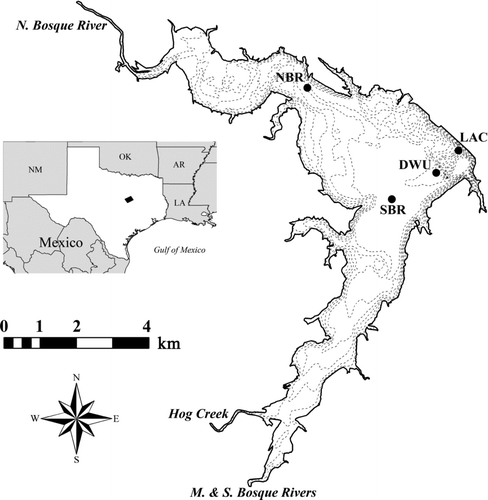
Figure 1 Lake Waco bathymetric map indicating North Bosque River (NBR), South Bosque River (SBR), deep-water upwelling (DWU), and lacustrine (LAC) sampling stations. Contour lines represent 5 ft (1.5 m) depth intervals and become deeper near dam. Bathymetry data were post-processed from original source (TWDB 2003). Inset map indicates McLennan County, TX
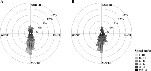
Southerly winds predominated throughout our study (; WBAN 13959; NOAA 2009); however, northerly and northeasterly winds were prevalent from November 2003 through May 2004 (). Wind speeds >10 m/s were more common during the November–May period than during the rest of our study. Wind speeds averaged 4.7 m/s with calm conditions (<0.5 m/s) occurring ∼6% of the time from November 2003 through May 2004. Southeasterly winds occurred more frequently from June through October 2004 (). Winds were gentler during this period (average = 3.7 m/s) with a greater occurrence of calm days (∼8%).
Figure 2 Local wind patterns during study (NOAA 2009). Data were temporally grouped from (A) Nov 2003 to May 2004 and (B) Jun to Oct 2004 to show contrasting wind patterns.
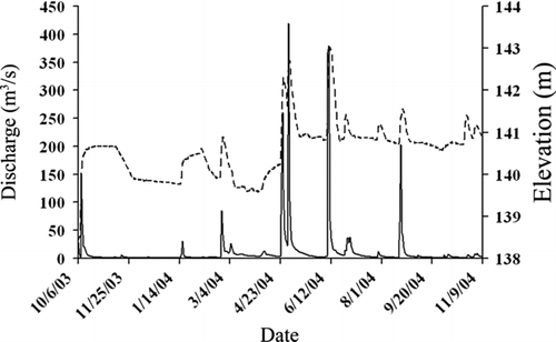
North Bosque River discharge experienced several large peaks during our study (; Station No. 08095200; USGS 2008). North Bosque River discharge peaked (>100 m3/s) on April 25 (∼260 m3/s), May 1 (∼420 m3/s), June 10 (∼380 m3/s), and August 20 (∼200 m3/s). Lake Waco water surface elevation increased concurrent with peak discharge events on April 25 and May 1 (; USACE 2008). Water surface elevation remained elevated thereafter.
Figure 3 North Bosque River discharge (solid line; USGS 2008) and Lake Waco water surface elevation (broken line; USACE 2008) during study.
Methods
Field and laboratory methods
We designated 4 sampling locations representing Lake Waco's different regions to adequately describe sediment resuspension in the reservoir. The North Bosque River (NBR) and South Bosque River (SBR) stations were located in the riverine–transition regions of the northern and southern arms, respectively (). The NBR was the shallowest location (zmean= 8.7 ± 0.4 m) and was closest to North Bosque River inflow. The SBR (zmean= 10.5 ± 0.5 m) was closest to Middle and South Bosque Rivers and Hog Creek inflow. The Lacustrine (LAC) and Deep Water Upwelling (DWU) stations were located in the lacustrine region (). The LAC was the deepest location (zmean= 15.0 ± 0.5 m) and farthest from tributary inflow. We believe DWU (zmean= 11.6 ± 0.4 m) was a location of water upwelling resulting from its proximity to a submerged, former dam face. Lake Waco, which was filled in 1965, impounded a smaller reservoir that lost most of its storage capacity due to sedimentation.
We deployed buoy-carried, anchored sediment traps semi-monthly or monthly for approximately one week duration from November 2003 through October 2004. Cylindrical sediment traps were manufactured from 5.08-cm i.d. polyvinyl chloride (PVC) pipes. Sediment traps had 2 vertical arms connected by a horizontal pipe to provide increased depositional surface area and balance in the water column. Sediment traps had 10:1 height:diameter ratios (H:D) similar to those used by CitationDouglas and Rippey (2000). Sediment traps with H:D > 5 have been recommended to avoid material loss (CitationBloesch and Burns 1980, CitationBlomqvist and Håkanson 1981). We suspended sediment traps at 2 depths per station. Photic sediment traps were suspended at 4 m depth (average photic depth of Lake Waco's lacustrine region) to collect inorganic particles sedimenting from the upper mixed layer and organic matter produced within the reservoir. Bottom sediment traps were suspended 1 m above the sediment–water interface to collect the aforementioned particles plus materials being secondarily transported within the reservoir. Secondarily-transported materials include particles resuspended from the sediment surface, particles experiencing horizontal advection (i.e., sediment focusing), and particles sedimenting from river inflow (i.e., river plume sedimentation; CitationHilton et al. 1986, CitationFord 1990).
Sediment trap contents were emptied into polypropylene bottles and stored at 4 C. Sediment slurry aliquots were filtered onto preweighed glass fiber filters. Samples were dried at 104 C until reaching constant weights to calculate total suspended solids (TSS). Samples were combusted at 550 C to determine inorganic suspended solids (ISS). Volatile suspended solids (VSS) were calculated as the difference between TSS and ISS using the loss-on-ignition method (CitationDean 1974). Areal sedimentation rates (g/m2/d) were calculated based on dry weights. Photic trap sedimentation rates measured net sedimentation, which consisted of allochthonous particles originating from the watershed and autochthonous in-lake production (CitationJames and Barko 1993). Bottom trap sedimentation rates measured gross sedimentation, which consisted of net sedimentation plus sediments that were secondarily transported within the reservoir (CitationJames and Barko 1993). We defined resuspension and percent resuspension as follows:
Mixing depth calculations
We used ArcGIS 9.3 software (ESRI, Inc.) to measure fetch distances at 10° wind angle intervals for each sampling station. We calculated effective fetch distances following USACE (1962) to account for relatively narrow fetch widths common in canyon reservoirs. This method includes fetch distances ±45° at 6° intervals from the desired wind angle. Wavelength and wave period were calculated according to the following equations:
Statistical considerations
We used a one-way analysis of variance (one-way ANOVA) to identify significant differences in TSS percent resuspension among stations (time inclusive). We used linear regression to model TSS percent resuspension as functions of mixing depth, mixing depth-to-site depth ratios (zmix:zsite), and North Bosque River discharge. Whole-lake and site-specific models were created for each independent variable. The aforementioned statistical analyses were evaluated at α= 0.05. We used multiple linear regression (MLR) to model TSS percent resuspension as a function of zmix:zsite and North Bosque River discharge at SBR. The TSS percent resuspension was significantly influenced by both wind mixing and river discharge at SBR only. Stepwise selection was used with α= 0.05 for variable entry and α= 0.10 for variable removal. Prior to statistical analyses, data distribution normality was tested by the Shapiro-Wilk test statistic based on our low sample sizes (N < 200). We used logarithmic and arcsine squareroot transformations to improve normality of positively skewed distributions and percentage data distributions respectively. Arcsine squareroot transformations typically improve proportional data normality by compressing middle values while spreading the ends (CitationMcCune and Grace 2002). Outliers, which were defined as values >1.5 interquartile ranges from Tukey's hinges, were identified and removed following data transformations. Statistical analyses were performed using SPSS 17.0 software (SPSS, Inc.).
Results
Sediment resuspension
Resuspension rates for TSS varied greatly at each site during our study ( and ). At NBR, TSS resuspension rates varied from 4 to 203 g/m2/d, with the highest rates occurring from June through August 2004 (). In contrast, TSS resuspension rates at SBR (9–168 g/m2/d) and DWU (17–296 g/m2/d) were typically greatest from November 2003 through February 2004. The 3 greatest resuspension rates lake-wide were at DWU. Resuspension rates of TSS varied from 18 to 96 g/m2/d at LAC but were not significantly different among stations (F3,72= 0.22, p=0.88) because of large within-site temporal variation. Resuspended sediments were composed of ∼90% inorganic materials ().
Table 2 Annual averages (± standard deviations) for TSS net and gross sedimentation rates (g/m2/d), resuspension rates (gross−net sedimentation rates, g/m2/d), and percent resuspension (resuspen-
sion rate/gross sedimentation rate, %) by sampling station.
Table 3 Inorganic and organic percent composition of TSS in photic and bottom sediment traps and resuspended materials by sampling station. Values reported as annual averages ± standard deviations.
Figure 4 TSS resuspension rate (bottom trap sedimentation rate − photic trap sedimentation rate) through time by sampling station.
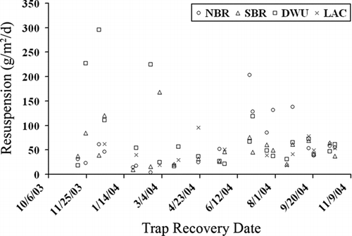
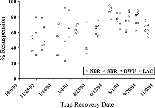
Whole-lake and site-specific TSS resuspension percentages varied widely during our study ( and ). From November 2003 through May 2004, resuspension patterns were spatially heterogeneous throughout Lake Waco. Lacustrine stations (DWU and LAC) typically had higher percentages of resuspended sediment than riverine stations (NBR and SBR; ). Resuspension percentages of TSS were more similar spatially from June through October 2004. During this period, NBR commonly had the greatest or second greatest percentages of resuspended materials. The greatest temporal variability (CV = 38%) in resuspension percentages () was recorded at NBR. Lake-wide TSS resuspension percentages were highest during June 2004 ().
Figure 5 TSS percent resuspension (resuspension rate/bottom trap sedimentation rate) through time by sampling station.
Sediment resuspension models
Mixing depth models did not adequately predict TSS resuspension percentages for the entire lake (Tables and ). Average mixing depth and average zmix:zsite based on daily resultant winds explained only 13 and 17% of TSS percent resuspension variability, respectively. However, mixing depth models were better at predicting TSS percent resuspension at DWU and SBR. Average mixing depth explained 30% of TSS percent resuspension variation at DWU (). Average zmix:zsite explained 20% of TSS percent resuspension variability at SBR (). Unexpectedly, TSS resuspension percentages were inversely related to mixing depth predictors for whole-lake and site-specific models. Mixing depth models were not significant at NBR and LAC. Models were not improved by considering mixing depths based on 2-minute or 5-second sustained winds.
Table 4 Linear regression models of TSS percent resuspension (arcsine squareroot transformed) as a function of average mixing depth (log10 transformed) based on daily resultant wind speeds and directions. Models are presented for significant regressions (α= 0.05) only.
Table 5 Linear regression models of TSS percent resuspension (arcsine squareroot transformed) as a function of mixing depth-to-station depth ratio (zmix:zsite; log10 transformed) based on daily resultant wind speeds and directions. Models are presented for significant regressions (α= 0.05) only.
North Bosque River discharge models (r 2= 0.19) explained slightly more TSS percent resuspension variability than mixing depth models (r 2= 0.17) for the entire lake ( and ). North Bosque River discharge also explained the most variability of TSS percent resuspension at the riverine stations (). North Bosque River discharge explained 44 and 30% of sediment resuspension at NBR and SBR, respectively; SBR was the only sampling location where sediment resuspension was significantly influenced by mixing depth and river discharge. Multiple linear regression explained 47% of TSS percent resuspension as a function of North Bosque River discharge and zmix:zsite at SBR (). River discharge models were not significant at DWU and LAC. Models were not improved by considering North Bosque River discharge prior to the deployment period (3, 5, 7, and 10 days).
Table 6 Linear regression models of TSS percent resuspension (arcsine squareroot transformed) as a function of average North Bosque River discharge (log10 – log10 transformed). Models are presented for significant regressions (α= 0.05) only.
Table 7 Multiple linear regression model of TSS percent resuspension (arcsine squareroot transformed) as a function of average North Bosque River discharge (log10 – log10 transformed) and z mix :z site (log10 transformed) based on daily resultant wind speeds and directions for the South Bosque River station.
Discussion
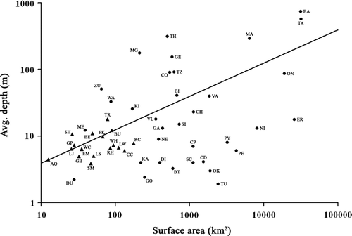
The dynamic ratio model (DR = (√lake area)/mean depth) identifies the importance of sediment erosion and transportation processes versus sediment accumulation processes in lakes (CitationHåkanson 1982). Based on Florida lakes, lakes with DR > 0.8 had sediment surfaces that were vulnerable to wave disturbance across the entire lake bottom (CitationBachmann et al. 2000). Central Texas reservoirs typically have DR ≈ 0.8 and smaller surface areas than large natural lakes (). Lake Waco (DR = 0.93) sediments should theoretically be prone to erosion and transportation processes across <33% of the lake bottom (CitationHåkanson 1982). However, dynamic ratio classifications may be biased in reservoirs due to morphological differences with natural lakes, which tend to be more circular. The dynamic ratio does not consider either wind speeds or effective fetch distances. Reservoirs may behave similarly to large, shallow natural lakes concerning sedimentation processes if their longitudinal axes are oriented to prevailing wind patterns, as is the case with Lake Waco.
Figure 6 Central Texas reservoirs (triangles; TWDB 2009) and large world natural lakes (circles; ILEC 2009) characterized by mean depth and surface area (modified from CitationHavens et al. 2007). Trendline represents dynamic ratio (DR =√surface area (in km2)/avg. depth (in m); Håkanson 1982) of 0.8 with lakes below this trendline (DR > 0.8) being increasingly affected by wind–wave mixing. Central Texas reservoirs include Aquilla (AQ), Belton (BE), Buchanan (BU), Cedar Creek (CC), Eagle Mountain (EM), Granbury (GB), Grapevine (GP), Lewisville (LW), Limestone (LS), Lyndon B. Johnson (LJ), Possum Kingdom (PK), Ray Hubbard (RH), Richland-Chambers (RC), Somerville (SM), Stillhouse Hollow (SH), Travis (TR), Waco (WC), and Whitney (WH). World natural lakes include Baikal (BA), Biwa (BI), Balaton (BT), Chad (CD), Champlain (CH), Constance (CO), Chapala (CP), Dianchi (DI), Dong-hu (DU), Erie (ER), Gatiun (GA), Geneva (GE), George (GO), Kasumiguara (KA), Kinneret (KI), Malawi (MA), Mendota (ME), Maggiore (MG), Neagh (NE), Nicaragua (NI), Okeechobee (OK), Ontario (ON), Peipsi (PE), Poyang (PY), St. Clair (SC), Simcoe (SI), Tanganyika (TA), Tahoe (TH), Tai-hu (TU), Taupo (TZ), Vattern (VA), Valencia (VL), Washington (WA), and Zurich (ZU).
We hypothesized that wind–wave mixing primarily determined sediment resuspension in Lake Waco, particularly in the lacustrine region. Mixing depth models did not support our hypothesis for the entire lake. Average mixing depth explained <20% of TSS percent resuspension variability (). We increased model explanatory power by considering depth differences among sites. However, zmix:zsite still explained <20% of TSS percent resuspension variability (). The model's poor explanatory power suggested that other sediment transport mechanisms, such as horizontal advection, induced sediment resuspension. CitationBailey and Hamilton (1997) emphasized the importance of including horizontal circulation in resuspension models. Alternatively, poor model explanatory power may have indicated that simple linear regression could not describe sedimentation processes in this spatially dynamic system.
Site-specific models revealed that wind–wave mixing significantly influenced sediment resuspension in the lacustrine region. Average mixing depth explained 30% of TSS percent resuspension variability at DWU (). This location coincided with both the northern and southern reservoir axes (). Prevailing wind patterns oriented along these relatively long effective fetches may have induced sediment resuspension throughout the year. This hypothesis was supported by the significant regression between TSS percent resuspension and zmix:zsite at SBR (r 2= 0.20, p< 0.05; ), which had similar fetch orientation. CitationFilstrup et al. (2009) identified sediment resuspension as a primary mechanism influencing gross sedimentation rates at DWU using organic matter isotopic composition mixing models. We believe that the nearby submerged dam face created localized upwelling areas that enhanced wind-induced sediment resuspension. Low sediment trap recovery rates (∼60%) likely influenced sediment resuspension–mixing depth relationships at LAC.
Unexpectedly, sediment resuspension was inversely related to mixing depth in Lake Waco ( and ). This result modified our conceptual model of sediment transport in Lake Waco. During horizontal transport, sediments likely settled and became concentrated with depth as distance from North Bosque River inflow increased. Wind-induced mixing likely entrained deep-water suspended sediments, thereby creating a more homogeneous water column (i.e., smaller sedimentation rate difference between photic and bottom sediment traps). During our study, mixing depths never reached the sediment surface (zmix:zsite< 1) even when considering 5-second sustained wind gusts. Therefore, wind-induced mixing likely did not resuspend surface sediments but rather mixed suspended sediments into the photic zone. CitationFilstrup et al. (2009) documented the importance of horizontal advection on organic matter sedimentation at DWU, which supports this proposed mechanism.
We hypothesized that northwesterly winter winds and prevailing southerly–southeasterly winds promoted sediment resuspension at southeasterly and northwesterly sampling locations, respectively. The TSS resuspension rates supported this hypothesis at stations where sediment resuspension was significantly influenced by wind-induced mixing. Resuspension rates were greatest at DWU and SBR from November 2003 through February 2004 () when strong northerly winds were common (). Although NBR exhibited greater resuspension rates from June through October 2004 () when winds were primarily from the south to southeast (), sediment resuspension and wind-induced mixing were not related at this site. The TSS percent resuspension did not support this hypothesis. Greater TSS resuspension percentages at NBR during summer () were largely influenced by North Bosque River discharge (see commentary below). The TSS resuspension percentages at DWU were similar year-round despite abnormally low values in November and May (). At SBR, percent resuspension values were typically lower from November 2003 through May 2004, which opposed our hypothesis. We believe this discrepancy originated from the unexpected reciprocal relationship between mixing depth and sediment resuspension in Lake Waco.
We hypothesized that storms strongly influenced sediment resuspension in Lake Waco. The accentuated influence of strong wind events on sediment resuspension has been demonstrated in several natural lakes (CitationBengtsson et al. 1990, CitationLuettich et al. 1990, CitationKristensen et al. 1992, CitationEvans 1994, CitationJames et al. 2008). Linear regression models were not substantially improved by including mixing depth variables based on 2-minute or 5-second sustained winds. We selected these 2 variables to characterize storm events because they were simple and readily available. We acknowledged that these theoretical maximum mixing depths were not likely to be realized in Lake Waco due to their short duration; however, mixing depths never exceeded site depths, suggesting that our sampling sites were sediment transport regions not sediment erosion regions. According to the dynamic ratio, erosion occurred over less than one-third of Lake Waco's sediment surface (CitationHåkanson 1982). Sediment erosion regions may have occurred at shallower locations in the riverine regions with sediments being subsequently horizontally advected throughout the reservoir.
Finally, we hypothesized that river discharge primarily determined sediment resuspension in the riverine regions. Large river discharge events along with wind speed explained suspended inorganic particle concentrations in a Swedish lake (CitationMarkensten and Pierson 2003). CitationEvans (1994) suggested that river currents be added to mechanisms directly influencing resuspension. North Bosque River discharge was the greatest single predictor of site-specific sediment resuspension at NBR (r 2= 0.44, p= 0.003; ) emphasizing the importance of river inflow on sediment transport in riverine regions. Both resuspension rates and percentages increased in June and remained elevated thereafter at NBR ( and ). This shift was potentially a delayed response to the large discharge events in late April through early June and the resulting lake elevation rise (). Additionally, North Bosque River discharge explained more sediment resuspension variability than wind-induced mixing at SBR (r 2= 0.30, p= 0.011; ). North Bosque River discharge may have served as an indicator of ungauged South and Middle Bosque river and Hog Creek discharge at SBR because their discharges are typically correlated. The SBR site may have been located in the transition region because it was the only station influenced by both river discharge and mixing depth (). Interestingly, lake-wide regression models revealed that river discharge (r 2= 0.19, p< 0.001; ) predicted TSS resuspension percent slightly better than wind-induced mixing (r 2= 0.17, p< 0.001; ). These relationships suggested that our resuspension metrics may have been influenced by horizontal advection in addition to sediment resuspension, especially in riverine regions.
Conclusions
Reservoir managers require models to adequately predict sedimentation processes and their influences on water quality and sustainability. In Florida natural lakes, CitationBachmann et al. (2000) demonstrated that greater dynamic ratios indicated poor water quality using total phosphorus, total nitrogen, chlorophyll a, and Secchi depth as water quality indicators. Similar studies relating widely applicable sedimentation models to water quality should be performed in reservoirs. However, sedimentation models require careful scrutiny and validation before reservoir application. Our findings suggested that models developed from natural lakes may not apply to reservoirs due to differing morphological and hydrological characteristics along reservoirs’ longitudinal axes. We propose that future reservoir models incorporate weighting factors to account for these differing sediment transport mechanisms among reservoir regions.
Acknowledgments
We thank Lisa Vajdos, Bradley Christian, and Rodrigo Moncayo-Estrada for their efforts in the field and laboratory. We thank Dr. Joseph White, Jeffrey Back, and Jason Taylor for assistance with statistical analyses. We thank Tom Conry and the City of Waco (Texas) for project support. This research was funded by the Environmental Protection Agency through an ENSR, Inc. subcontract (#102200) to O. T. Lind. Partial funding was provided by the Folmar and Gardner Graduate Student Research Grants through Baylor University to C. T. Filstrup.
Notes
*Standard error.
**Standard error of the estimate.
*Standard error.
**Standard error of the estimate.
*Standard error.
**Standard error of the estimate.
†Variable not normally distributed (Shapiro-Wilk p= 0.045).
*Standard error.
**Standard error of the estimate.
References
- Bachmann , R W , Hoyer , M V and Canfield , D E . 2000 . The potential for wave disturbance in shallow Florida lakes . Lake Reserv Manage. , 16 : 281 – 291 .
- Bailey , M C and Hamilton , D P . 1997 . Wind induced sediment resuspension: a lake-wide model . Ecol Model. , 99 : 217 – 228 .
- Bengtsson , L , Hellström , T and Rakoczi , L . 1990 . Redistribution of sediments in three Swedish lakes . Hydrobiologia , 192 : 167 – 181 .
- Bloesch , J and Burns , N M . 1980 . A critical review of sedimentation trap technique . Schweiz Z Hydrol. , 42 : 15 – 55 .
- Blomqvist , S and Håkanson , L . 1981 . A review on sediment traps in aquatic environments . Arch Hydrobiol. , 91 : 101 – 132 .
- Carper , G L and Bachmann , R W . 1984 . Wind resuspension of sediments in a prairie lake . Can J Fish Aquat Sci. , 41 : 1763 – 1767 .
- Dean , W E . 1974 . Determination of carbonate and organic matter in calcareous sediments and sedimentary rocks by loss on ignition: comparison with other methods . J Sediment Petrol. , 44 : 242 – 248 .
- Douglas , R W and Rippey , B . 2000 . The random redistribution of sediment by wind in a lake . Limnol Oceanogr. , 45 : 686 – 694 .
- Dworkin , S I . 2003 . The hydrogeochemistry of the Lake Waco drainage basin, Texas . Environ Geol. , 45 : 106 – 114 .
- Evans , R D . 1994 . Empirical evidence of the importance of sediment resuspension in lakes . Hydrobiologia , 284 : 5 – 12 .
- Filstrup , C T , Scott , J T and Lind , O T . 2009 . Allochthonous organic matter supplements and sediment transport in a polymictic reservoir determined using elemental and isotopic ratios . Biogeochemistry , 96 : 87 – 100 .
- Filstrup , C T , Scott , J T , White , J D and Lind , O T . 2010 . Use of sediment elemental and isotopic compositions to record the eutrophication of a polymictic reservoir in central Texas, USA . Lakes Reserv Res Manage. , 15 : 25 – 39 .
- Ford , D E . 1990 . “ Reservoir transport processes ” . In Reservoir limnology: ecological perspectives , Edited by: Thornton , K W , Kimmel , B L and Payne , F E . 15 – 41 . New York , (NY) : John Wiley and Sons, Inc .
- Håkanson , L . 1982 . Lake bottom dynamics and morphometry: the dynamic ratio . Water Resour Res. , 18 : 1444 – 1450 .
- Havens , K E , Jin , K R , Iricanin , N and James , R T . 2007 . Phosphorus dynamics at multiple time scales in the pelagic zone of a large shallow lake in Florida, USA . Hydrobiologia , 581 : 25 – 42 .
- Hilton , J , Lishman , J P and Allen , P V . 1986 . The dominant processes of sediment distribution and focusing in a small, eutrophic, monomictic lake . Limnol Oceanogr. , 31 : 125 – 133 .
- [ILEC] International Lake Environmental Committee . 2009 . World lakes database http://www.ilec.or.jp Accessed 4 Jun 2009
- James , R T , Chimney , M J , Sharfstein , B , Engstrom , D R , Schottler , S P , East , T and Jin , K R . 2008 . Hurricane effects on a shallow lake ecosystem, Lake Okeechobee, Florida (USA) . Fund Appl Limnol. , 172 : 273 – 287 .
- James , W F and Barko , J W . 1993 . Sediment resuspension, redeposition, and focusing in a small dimictic reservoir . Can J Fish Aquat Sci. , 50 : 1023 – 1028 .
- Kimmel , B L and Lind , O T . 1972 . Factors affecting phytoplankton production in a eutrophic reservoir . Arch Hydrobiol. , 71 : 124 – 141 .
- Kimmel , B L , Lind , O T and Paulson , L J . 1990 . “ Reservoir primary production ” . In Reservoir limnology: ecological perspectives , Edited by: Thornton , K W , Kimmel , B L and Payne , F E . 133 – 193 . New York , (NY) : John Wiley and Sons, Inc .
- Kristensen , P , Søndergaard , M and Jeppesen , E . 1992 . Resuspension in a shallow eutrophic lake . Hydrobiologia , 228 : 101 – 109 .
- Lind , O T . 1971 . “ The organic matter budget of a central Texas reservoir ” . In Reservoir fisheries and limnology , Edited by: Hall , G E . 193 – 202 . Washington , (DC) : American Fisheries Society . Spec. Pub. 8, American Fisheries Society
- Lind , O T and Barcena , E . 2003 . Response of riverine and transition zone bacterioplankton communities to a pulsed river inflow . Hydrobiologia , 504 : 79 – 85 .
- Luettich , R A , Harleman , D RF and Somlyódy , L . 1990 . Dynamic behavior of suspended sediment concentrations in a shallow lake perturbed by episodic wind events . Limnol Oceanogr. , 35 : 1050 – 1067 .
- Markensten , H and Pierson , D C . 2003 . A dynamic model for flow and wind driven sediment resuspension in a shallow basin . Hydrobiologia , 494 : 305 – 311 .
- McCune , B and Grace , J B . 2002 . Analysis of ecological communities , Gleneden Beach , (OR) : MjM Software Design .
- [NOAA] National Oceanic and Atmospheric Administration . 2009 . National climatic data center http://www.ncdc.noaa.gov/oa/ncdc.html Accessed 13 Oct 2009
- Rowan , D J , Kalff , J and Rasmussen , J B . 1992 . Estimating the mud deposition boundary depth in lakes from wave theory . Can J Fish Aquat Sci. , 49 : 2490 – 2497 .
- [TWDB] Texas Water Development Board . 2003 . Volumetric survey of Waco Lake , Austin , (TX) : Texas Water Development Board .
- [TWDB] Texas Water Development Board . 2009 . http://wiid.twdb.state.tx.us Reservoir summary report Accessed 4 Jun 2009
- Thornton , K W . 1990 . “ Perspectives on reservoir limnology. ” . In Reservoir limnology: ecological perspectives , Edited by: Thornton , K W , Kimmel , B L and Payne , F E . 1 – 13 . New York , (NY) : John Wiley and Sons, Inc .
- [USACE] United States Army Corps of Engineers-Beach Erosion Board . 1962 . Waves in inland reservoirs: summary report on civil works investigation projects CW-14 and CW-165 , Washington , (DC) : Beach Erosion Board .
- 2008 . [USACE] United States Army Corps of Engineers-Fort Worth District http://www.swf-wc.usace.army.mil Hydrologic data on Ft. Worth district lakes Accessed 15 Sep 2008
- [USGS] United States Geological Survey . 2008 . Water data for USA http://waterdata.usgs.gov Accessed 15 Sep 2008