Abstract
As a water supply, Lake Waco, Texas, is subject to the provisions of the Safe Drinking Water Act and related regulations. Aside from concern over primary contaminants that affect human health, there have been taste and odor incidents of increasing frequency, duration and severity over the last decade; therefore, this comprehensive study was developed to define historical and existing water quality conditions and to project possible management scenarios. Practical management approaches to maintain or improve existing water quality conditions within the lake and immediate watershed were identified and evaluated for implementation. The declining water quality within the lake necessitated the construction of an additional treatment process at a cost of $40 million to facilitate compliance with newer drinking water regulations. The investigators sought to assess the magnitude and relative size of water and nutrient contributions to Lake Waco, allowing assessment of loading in relation to acceptable levels for maintaining desired conditions in the reservoir. Thirty-five specific tasks (studies) were conducted concurrently, investigating specific issues or mechanisms of interest in relation to the lake, its watershed and its users. The majority of the $2 million study cost was provided by the City of Waco, although the US Army Corps of Engineers, US Environmental Protection Agency, US Geological Survey, and Texas Parks and Wildlife Department made important contributions to the study.
Key words:
This introduction provides background on Lake Waco, Texas, the contributing watershed, and the overall Lake Waco Comprehensive Study approach and objectives. Subsequent journal articles will address specific tasks.
Lake Waco serves as a water supply for roughly 200,000 people in Central Texas. The reservoir is subject to the provisions of the Safe Drinking Water Act and related regulations. This requires treatment to meet a wide variety of standards, and such treatment is minimized, with regard to technical aspects and cost, by source quality control and protection. For example, total organic carbon levels have increased, and dissolved organic carbon can affect the formation of disinfection by-products during water treatment for potable uses. Beyond the need to minimize primary contaminants that affect human health, taste and odor incidents of increasing frequency, duration, and severity over the last decade have prompted concern over algal blooms in Lake Waco. Taste and odor control is both technically difficult and costly, again indicating the desirability of source quality control. The cost of treating Lake Waco water to drinking water standards rose 4-fold in less than 10 years, and the costs associated with taste and odor increased to more than $500,000 per year.
Managing Lake Waco and its watershed to meet use goals effectively requires:
| • | An understanding of the history of the reservoir | ||||
| • | Background on the climate, geology, land uses and related activities in the watershed | ||||
| • | Recognition of the timing and variability of inputs | ||||
| • | Knowledge of in-lake processes that affect water quality | ||||
The Lake Waco Comprehensive Study sought to provide the necessary data and analyses to facilitate effective management planning.
History of Lake Waco
In the late 1800s, the City of Waco citizens were dependent on individual or small local wells for all domestic and commercial water uses. When some of these wells began to decline in production or water quality, the city purchased private water companies, consolidating those systems. As the city's population grew, increased water consumption upstream resulted in a decrease in stream flow of the Brazos River, then the city's primary water supply.
In the 1920s, the City of Waco foresaw the need to build a dam on the Bosque River to produce potable water. The original Lake Waco Dam was completed in 1930 on the lower Bosque River with a storage capacity of roughly 48 million m3 (39,000 acre-feet). By 1938, the US Army Corps of Engineers recommended building a new dam for better flood control.
Twenty years later, construction began on the current Lake Waco Dam. Through an authorization from Congress, Waco gained priority water rights to the over 48 million m3 and the option of acquiring additional water rights. Lake Waco Dam was completed in 1964, giving the city a long-term, dependable water supply. Waco acquired water rights to 72.8 million m3(59,000 acre-feet) of water from Lake Waco, the only Corps lake entirely within one municipality's city limits in the United States.
Between 1979 and 1983, the City of Waco and the Brazos River Authority requested that the US Army Corps of Engineers conduct a feasibility study on raising the lake level. In 1983, the Corps reported that it was feasible to raise the lake 2 m. That same year, the city signed an agreement with the Corps to raise the lake for water conservation purposes.
In 1998, the Waco City Council voted to increase the lake's conservation pool water level by 2 m as a part of the city's 50-yr water plan in reaction to the Texas Legislature's 1997 Senate Bill 1 that required specific water plans to be developed for the state. By increasing the conservation pool, Lake Waco provides 97.5 million m3 (79,000 acre-feet) of sustainable annual yield, guaranteeing a sufficient drinking water supply for most of Central Texas and resulting in the City of Waco being designated as a regional water supplier. Raising the lake's conservation level 2 m not only insures a water supply for the next 50 years, but also brings economic benefits and recreational opportunities to the city.
In addition to being a critical water supply for Central Texas, Lake Waco is an important economic asset. Lake Waco is strategically located within Central Texas, with 5 million Texans, or roughly 25% of the Texas population, living within 100 miles of the lake. The lake has significant recreational use that provides an economic advantage (between $16 and $27 million dollars per year) to Central Texas. Additionally, the lake is designed for flood protection and has reduced flooding destruction in the Waco area. The initial dam construction cost, in 1963 dollars, was $21,734,250, with a total project cost (including recreation facilities, boat ramps and other facilities) of $49,704,000. The annual budget for the Lake Waco Corps Project Office is around $1.6 million per year.
Watershed characteristics
The tributaries draining the Lake Waco watershed () are typical of Central Texas stream morphology and have relatively low baseflow with drastic flooding events. This results in a large influx of sediment and nutrients during the flooding events and very little loading (relative to the flooding) during baseflows. These significant nutrient and sediment “pulses” from floods create a unique dynamic for the aquatic communities, particularly macrophytes (aquatic plants) and algae.
Figure 1 (a) River basins associated with Lake Waco. (b) Location of dairy operations and wastewater discharges in the Lake Waco watershed.
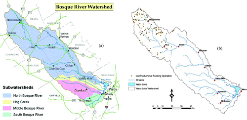
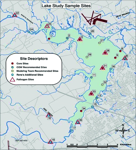
Figure 2Sampling stations within Lake Waco.
The Waco Lake basin covers approximately 4244 km2 (1640 mi2) within the Cross Timber and Lampasas Cut Plains of the central Texas Great Plains (CitationKier et al. 1977). Climate is subhumid and thermic (CitationKier et al. 1977, CitationBull, 1991), with an ustic soil moisture regime. Average precipitation and temperature from 1999 to 2004 was approximately 817 mm and 18 C, respectfully. Precipitation is weakly seasonal with the driest months during the winter and wettest during the late spring. Temperatures are strongly seasonal with July as the hottest month and January as the coolest. There are approximately 6318 yearly heat units at McGregor, Texas, in the southern study area.
The elevation of the Waco Lake Basin ranges from approximately 114 to 493 m a.s.l. and is underlain by gently southeastern dipping sedimentary bedrock. Outcrops expose a general progression of sandy continental units in the upper watershed that transition to clay-rich marginal marine units, which transition to neritic limestones and clays in the lower Waco Lake Basin (CitationSellards et al. 1990). The layer-cake stratigraphy has resulted in a generally dendritic stream network. Outcrops of indurate limestone (especially Edwards Limestone) tend to form subwatershed drainage divides, while less competent shale and sandstone formations crop out in dissected alluvial valleys.
Low-order tributary streams (i.e., Hog Creek) that transect interfluval areas are characterized by constricted channels and floodplains that result in frequent flash floods (CitationProchnow 2001). Soil formation is largely controlled by bedrock outcrops because variability in climate, topography and biota is minimal within the Waco Lake basin.
The study area is mostly within the Kansan and Texan biotic provinces of CitationBlair (1950). This region is characterized by a very slight moisture surplus index, oak–hickory forests on sandy soils and tall-grass species on clay soils in the natural state. Rangeland (62.4%) and forests (19.4%) are still the dominant land cover, but agriculture and urbanization now account for 15.4% and 1.3% of the Waco Lake basin, respectively. However, wetlands and water cover (stock tanks and private ponds) account for slightly more area than urbanization.
The watershed was 147 times the area of the reservoir prior to pool rise, a large watershed to lake area ratio. After pool rise, the watershed is now 117 times the reservoir area, still a large ratio. The change in ratio is not significant in terms of watershed management planning. A watershed of such size, relative to the lake into which it drains, has the potential to dominate water quality in that lake through runoff processes. The length of the watershed (<160 km in the North Bosque River) affects the inflow concentrations (). The greatest nutrient concentrations are linked to waste application fields where manure is applied at 2 or more times the crop use rate, and these fields are located in the upper watershed; therefore, the last water to arrive at the lake in response to a storm exhibits the poorest quality. This “backloading” in association with rainfall events, with the highest concentrations during declining hydrographs, is somewhat unusual.
There are several identified sources of nutrients in the Lake Waco watershed (). Confined Animal Feeding Operations (CAFOs) in the watershed () are industrial dairy farms (250–4500 head of cows on small acreage) that have been the subject of considerable regulatory and legal action as a consequence of
| • | High levels of nutrients in dairy cattle wastes | ||||
| • | Wastes being spread on acreage in the watershed at 3–10 times the crop uptake rate, resulting in excessive nutrient (nitrogen and phosphorus) levels in runoff | ||||
| • | Concentration of CAFOs in the upper portion of the North Bosque River watershed | ||||
Table 1 Land uses in the Lake Waco basin, with percentage contributions to watershed area and nutrient loading to Lake Waco.
Other livestock operations exist throughout the watershed, although not at the concentration observed for CAFOs, but the manure related to these less intensive livestock land uses may still threaten water quality, at least on a localized basis. Cropland also is substantial and is a major land use in the Middle and South Bosque rivers, where runoff from tilled soil, especially when fertilized, may add nutrients to watercourses (TCEQ 2008).
There are 8 wastewater treatment facilities (WWTF) serving multiple communities within the watershed (one each with all upstream communities in ). Discharges go to the North and South Bosque rivers; the Crawford WWTF evaporates all effluent and does not have an actual discharge to the Middle Bosque River. All but the Stephenville WWTF are small operations, at less than one million gallons per day. Runoff from urbanized areas is less of a threat than in many other watersheds but is still a source to Lake Waco, particularly from the developed areas near the lake.
Direct inputs to the lake include ground water seepage, atmospheric dry fall and precipitation, recreational inputs (mainly wastes from boats), waterfowl wastes and releases from sediment (internal loading). The quality of ground water inputs is likely to be determined by the nature of the overlying land uses and the filtering capacity of the soils through which the ground water passes on its way to the lake. The other direct inputs are not subject to purification processes prior to entry to the lake and can be estimated from a variety of approaches. A detailed study was conducted only for internal loading because the variability associated with this source is very high among lakes, making site specific evaluation important for an accurate loading assessment.
General lake conditions
Lake Waco is located in a humid subtropical climate with no significant recharge source other than rainfall runoff in the approximately 4244 km2 (1640 mi2) watershed. The watershed is primarily within the Central Oklahoma–Texas Plains ecoregion (from Omernick), with some Blackland Prairie ecoregion areas. The annual average rainfall within the watershed is approximately 82.19 cm (32.36 in), falling mostly in winter and spring.
The pre-pool rise conservation pool surface area of Lake Waco was 29.4 km2 (7194 ac) at an elevation of 138.6 m (455 ft) a.s.l. In October 2003, the average lake level was raised to an average elevation of 140.7 m (462 ft) a.s.l. There are 3 primary direct inflows: the South and Middle Bosque rivers (∼20%), Hog Creek (∼4%), and the North Bosque River (∼70%). There is some direct storm runoff (∼1%) into the lake from the cities of Waco and Woodway and from agricultural and suburban areas near the lake. The dam is 7503.6 m in length with a maximum height of 42.6 m above the streambed of the Bosque River (http://swf67.swf-wc.usace.army.mil/waco/wacolake.htm, accessed May 2010).
Lake Waco is a moderate to shallow depth polymictic lake with a normal maximum depth around 26 m (81 ft) near the dam. This lake level change resulted in peripheral flooding of shallow and lowland areas along the shoreline with a change in average surface area from 29.42 km2 to 35.30 km2 (∼8800 ac). Average depth of the reservoir has increased slightly with this increase in conservation pool from 6.1 m (CitationSullivan et al. 1995) to 6.8 m (derived from this study), a characteristic that may account for wind-driven waves resuspending sediment from shallow areas in the lake. The lake has an unobstructed length (fetch) of more than 5.63 km (3.5 mi) that can accentuate the wind effect. Waves can be less than a foot high near the beginning of the fetch and more than 3 ft high near the dam, located at the far end of the predominant wind direction.
These contributing watershed conditions result in a eutrophic lake system. Sediment and nutrient loadings are higher in Texas lakes than in most temperate lakes. The initial (1929) Lake Waco did have high sediment loading, leading to the need for a second, larger lake. However, those sediment loads were significantly reduced during the 1960s as the 40 Public Law 566 detention structures (lakes) were constructed in the upper North Bosque River watershed.
Beginning in the late 1980s, CAFO growth coincided with higher sediment and phosphorus loading, as evidenced by paleolimnology data (CitationFilstrup et al. 2010). Algae populations began to change, and taste and odor events were experienced throughout the 1990s and into this century (unpublished Waco plankton and customer complaint data). Algal samples have been collected from Lake Waco and analyzed for more than 4 decades, although frequency, locations, methods, personnel and record keeping have varied. At least some data are available from each decade, going back to the 1960s when the current dam was installed and the reservoir was expanded. These unpublished data document the increase in cyanobacteria over time in Lake Waco, potentially elucidating the reason for increased taste and odor in recent years. Actual taste and odor are less well studied, with only more recent tests of the quantity of methylisoborneol and geosmin, along with general records of complaints from customers and observations by treatment facility personnel.
The pre-pool rise aquatic plant community was dominated by the family Polygonaceae (smartweed). Because the macrophyte population is limited to the shoreline and water depths of 3 ft, algae are the primary competitors for nutrient uptake. Increases in the macrophyte population through off-channel wetlands and establishing plants in the shallow (littoral) areas created by the pool rise was considered a possibility and might inhibit algae to some extent. Invasion by Hydrilla is a related concern.
Study overview
In the watershed, efforts were focused on quantifying loading of water, nutrients, fecal bacteria and sediment from major sources in each of the defined major subwatersheds. Inputs from dairy operations, wastewater treatment facility discharges and urban runoff near the lake were emphasized, but nearly all sources were investigated. Possbile perchlorate inputs from a nearby military depot were also investigated but were not found to be a significant source or influence for Lake Waco. Watershed processes were modeled with SWAT.
In the reservoir itself (), efforts included physical, chemical and biological aspects of Lake Waco. The new bathymetry and morphometry of the reservoir was evaluated with GIS technology, and circulation patterns and sedimentation/resuspension were studied. Chemical monitoring included extensive assessment of nutrient levels, temperature, oxygen, pH, total organic carbon, chlorophyll and other water quality features of primary concern over 3 years. Assessment of biological components included basic identification and quantification of algae, rooted plants, zooplankton and macroinvertebrates. Fish community features were provided by Texas Department of Parks and Wildlife efforts separate from this study (CitationTibbs and Baird 2004). Pathogens in Lake Waco were also monitored. Paleolimnological aspects of the reservoir were assessed from core samples.
Key biological processes evaluated included algal growth potential and nitrogen fixation. Internal recycling of nitrogen and phosphorus were also quantified. In-lake processes were modeled using CE-Qual-W2 with SWAT outputs used as lake inputs, with nitrogen and phosphorus levels as important dependent variables.
Management topics covered included the economics of Lake Waco, possible manure handling options, wastewater treatment considerations, urban runoff management, various land use changes, possible phosphorus inactivation and biomanipulation. Pre- and post-pool rise comparisons were made, and recent data trends were analyzed.
The Lake Waco Comprehensive Study capitalized on considerable research effort by multiple groups in prior years, most notably studies by the Texas Institute of Applied Environmental Research at Tarleton State University in Stephenville, Texas. The majority of the $2 million study cost was provided by the City of Waco, although the US Army Corps of Engineers, US Environmental Protection Agency, US Geological Survey, and Texas Parks and Wildlife Department made important contributions to the study.
Conclusion
With the importance of Lake Waco as a water supply and recreational resource in Central Texas, the Lake Waco Comprehensive Study was undertaken to gather data essential to evaluating management needs and options. While potentially similar to many other southwestern reservoirs, Lake Waco has significant differences from most temperate zone lakes that limit transferability of many lake management axioms from those well studied systems and necessitate site-specific analysis of the mechanisms leading to observed conditions and changes over time. A series of 35 interrelated tasks was completed to support this effort, with an overall report generated from the results (ENSR 2006). Physical, chemical and biological components of the lake have been investigated, and relationships between land use and contaminant loading have been evaluated. In-lake processes that influence water quality have been assessed. Overall management needs and feasible approaches to improving and protecting water quality in Lake Waco have been outlined. Individual papers produced from selected separate task reports constitute the following papers in this issue of Lake and Reservoir Management.
References
- Blair , W F . 1950 . The biotic provinces of Texas . Tex J Sci. , 2 : 93 – 116 .
- Bull , W B . 1991 . Geomorphic response to climate change , New York , (NY) : Oxford University Press .
- ENSR/AECOM . 2008 . Lake Waco Comprehensive Lake Management Study: Summary Report , Westford , (MA) : ENSR/AECOM .
- Filstrup , C T , Scott , J T , White , J D and Lind , O T . 2010 . Use of sediment elemental and isotopic compositions to record the eutrophication of a polymictic reservoir in central Texas, USA . Lake Reserv Res Manage. , 15 : 25 – 39 .
- Kier , R S , Graner , L E and Brown , L F Jr . 1977 . Land resources of Texas, Special Bulletin, Bureau of Economic Geology , 45 Austin , (TX) : University of Texas at Austin .
- McFarland , A and Hauck , L . 1999 . Existing nutrient sources and contributions to the Bosque River watershed , Stephenville , (TX) : Tarleton State University . TIAER PR9811
- Prochnow , S J . 2001 . Geoarchaeology and Slackwater Paleoflood modeling at Horn Shelter No. 2 along the Brazos River . B South Tex Geol Soc. , 42 : 15 – 25 .
- Sellards , E H , Adkins , W S and Plummer , F F . 1990 . The Geology of Texas: Volume 1, Stratigraphy , 1007 Austin , (TX) : University of Texas. Bureau of Economic Geology .
- Sullivan , S , Thomas , D , Elliott , W and Segura , S . 1995 . Volumetric Survey of Waco Lake , Austin , (TX) : Hydrographic Survey Group, Texas Water Development Board .
- [TCEQ] Texas Commission on Environmental Quality . 2008 . Water quality in the North and Upper North Bosque rivers, January 2008: status report of activities to address elevated nutrient concentrations , Austin , (TX) : TCEQ .
- Tibbs , J and Baird , M S . 2004 . 2003 Survey report for Lake Waco Statewide Freshwater Fisheries Monitoring and Management Program, Texas Parks and Wildlife, Inland Fisheries Division
