Abstract
The nearshore areas of lakes respond quickly to watershed runoff, increases in tributary inflows from annual snowmelt, and increased anthropogenic activity in the basin. Therefore, this area of the lake serves both as an early warning system for water quality degradation and as an indicator of the effectiveness of land management practices or sediment control projects. In this study we evaluated the usefulness of combining fine-scale water quality measurements and discrete particle sample analysis to gain a better understanding of seasonal and spatial trends in the nearshore area of Lake Tahoe. Turbidity and mineral composition at 0.5 m depth were measured in nearshore waters near the City of South Lake Tahoe at a spatial resolution of 5–30 m in 2002 and 2003. Particles filtered from discrete samples collected 200 m from shore were analyzed by scanning electron microscopy and chemical analysis using quantum electron dispersive spectrometry. Baseline turbidity levels were extremely low (0.15 NTU) during calm periods in the fall but rose to levels above 4.0 NTU in response to winter and spring precipitation events and spring snowmelt runoff. Discrete samples collected 200 m from shore contained over 80% organic material during the dry part of the year and at least 50% mineral particles during the winter and spring. The effectiveness of this method for detecting variability in nearshore conditions at Lake Tahoe is promising for monitoring the littoral areas of other pristine lakes facing increased anthropogenic pressure and other watershed disturbances.
Anthropogenic effects due to urbanization, increased agricultural activities, and the introduction of non-native species alter natural conditions and can affect water quality. Water clarity is a key indicator of water quality and, when observed over a period of months to years, can provide valuable information about changes in lake chemistry, allocthonous inputs, and balance within the foodweb. Reduction in clarity affects aquatic ecology and reduces the visual range of recreational users and the aesthetic value of the lake (CitationDavies-Colley et al. 1993). Seasonal variability in water clarity may result from surface runoff or tributary input, wave-induced resuspension of sediments, internal sediment loading, patterns of algal production, and biomass accumulation and other factors.
Water clarity is traditionally monitored by Secchi depth measurements, an apparent optical property that measures the attenuation of visual contrast, and more recently by inherent optical properties such as turbidity, which describes the amount of light scattered at a specified angle. Predictive models have also been used to simulate water clarity variation in water bodies (CitationBuiteveld 1995, CitationHakanson 2006, CitationSwift et al. 2006). Alternatively, spatial estimations of water clarity can be obtained by linking Landsat imagery to in-lake clarity measurements (CitationKloiber et al. 2002a and Citation2002b, CitationStreissberg et al. 2005, CitationBinding et al. 2007, CitationOlmanson et al. 2008).
Each of these technologies has benefits and limitations. Secchi disk measurements are easy to understand, inexpensive, and have often been collected over a period of many years (such as in Lake Tahoe, where more than 35 years of data have been recorded by the Tahoe Research Group of University of California Davis). The disadvantage of this method is that it requires clear, calm weather conditions, and readings can only be taken in waters where the bottom is not visible. While models provide good predictive possibilities and linkages between multiple variables, they often fail to capture subtle changes in lake water clarity because of the complex influences on this parameter. Landsat data are now widely available and can provide information over a large spatial area; however, data are limited by satellite frequency and cloud cover, as well as resolution.
This study provides a novel approach to measuring water clarity in the shallow areas closest to the shoreline, where Secchi disks are inappropriate because the lake bottom is visible. The method is applied to Lake Tahoe, a deep mountain lake known for its exceptional clarity, but would be appropriate for any lake where clarity is high enough to see the bottom in areas of recreational or ecological concern. With increasing anthropogenic activity around the lakeshore, the little-studied nearshore area of Lake Tahoe is an ideal place to examine spatial and seasonal trends in water clarity. In general, clarity changes related to watershed runoff after precipitation events or during annual snowmelt are most clearly seen in the nearshore waters where the greatest concentration of particles enters the lake. The nearshore zone, therefore, shows fast and local response to land use changes that cause variation in runoff levels, suspended solids, and nutrients (CitationBiggs and Davies-Colley 1990, CitationLambert and Cattaneo 2008). This makes it a logical place to evaluate the effectiveness of land management practices and sediment control projects.
Materials and methods
Study site
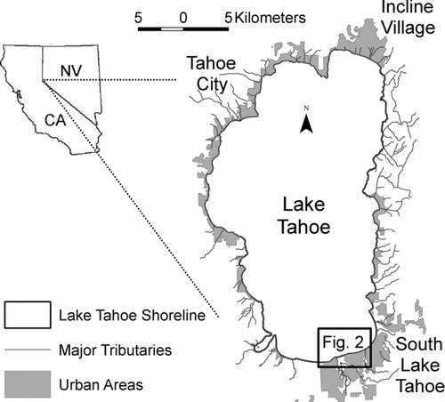
Lake Tahoe is an ultra-oligotrophic, mountain lake straddling the border between California and Nevada (). It has a surface elevation of 1897 m, and with a maximum depth of 501 m; it is the 10th deepest lake in the world (CitationSchuster and Grismer 2004). Lake Tahoe is roughly 35 km long and 19 km wide with a mean depth of 313 m. The considerable volume and low outflow of the lake result in a long hydraulic residence time, estimated at about 650 years (CitationJassby et al. 2003). The surface area of the lake and the entire drainage basin are approximately 500 km2 and 800 km2, respectively. The lake surface is therefore 63% of the total area of the watershed, leading to exceptional clarity and Secchi depths of up to 40 m during initial studies in 1967 (CitationJassby et al. 2003), but midlake clarity has declined more than 10 m since that time (CitationJassby et al. 2003). The Lake Tahoe basin is now home to roughly 60,000 year-round residents and supports over 22 million visitors annually (CitationForney et al. 2001).
Figure 1 Location of the South Lake Tahoe, CA, study area.
The Upper Truckee River is the largest tributary to the lake and flows through the City of South Lake Tahoe (). It is the largest contributor of sediment load to the lake (CitationReuter and Miller 2000), although it ranks only intermediate in terms of sediment concentration because of its relatively high flow volume. Average annual total suspended sediment concentration for 9 sampled Lake Tahoe tributaries ranged from 15 to 616 mg/L, with the Upper Truckee contributing an average of 43 mg/L annually. The City of South Lake Tahoe is also the largest population center in the Tahoe basin and is a popular tourist destination, making the aesthetic quality of nearshore waters important. This area is therefore a pertinent place to study the relationship between clarity and stream input.
Methods
The focus of this study was the spatial and temporal variability of clarity in the nearshore water adjacent to the outlet of the Upper Truckee River. The nearshore area was defined as starting from 1 m water depth and extending offshore until a depth of at least 30 m. A shallow shelf extends out from the South Lake Tahoe area, resulting in a nearshore area that extends approximately 1–1.5 km offshore.
In-lake turbidity measurements were collected on 23 dates between July 2002 and August 2003 at a fine resolution (every 5–30 m) across a wide portion of the southern shore of Lake Tahoe and extending at least 1.5 km offshore. Turbidity was selected as the main indicator of water clarity because it is already used for regulatory purposes in the shallow region of Lake Tahoe (TRPA 2007). The 2 turbidimeters used for this study were a Hach 2000 and a Hach 2100AN (Loveland, CO). Both instruments measured turbidity by US Environmental Protection Agency Method 180.1 (USEPA 1999), which specifies a wavelength of 400–600 μm and a detection angle of 90°. Comparison of the values recorded by the 2 turbidimeters was evaluated as measurements were collected for fast error identification. Surveys of turbidity were performed near the shore of the City of South Lake Tahoe, from Tahoe Keys Marina to just east of Bijou Creek (). A boat was equipped with an adjustable sampling probe mounted to the bow, with a pump that fed lake water to the instruments in the boat's cabin. Water was continuously collected at a depth of approximately 0.5 m while the boat was moving at speeds between 8 and 35 km/h. Turbidity and temperature measurements were recorded every 5–30 m. A data acquisition system recorded location and turbidity readings, checked for instrument malfunctions such as air bubbles or pump failures, and displayed the data as a color-coded map as they were collected. A set path was followed during each survey for consistency; however, water levels, equipment malfunctions and recreational traffic in the lake sometimes caused the boat operator to deviate from the normal routine. When elevated turbidity was observed past the normal study area, surveys were extended out to approximately 2.5 km from shore. A subset of the data were extracted at transects 0.5 and 1.0 km offshore (). The 0.5 km distance was chosen because it was the closest transect that had a complete set of data because lake levels closer to shore were often too shallow for boat operation. The 1.0 km transect exemplifies conditions in the far nearshore area before the water depth increases rapidly. Beyond the 1.0 km transect, spatial variation was rarely observed.
Figure 2 Nearshore area by the City of South Lake Tahoe. The locations for the turbidity transects at distances of 0.5 and 1.0 km from the shore (marked with a bold line) are shown by dashed lines. The large black dot marks the location approximately 250 m offshore from the outlet of the Upper Truckee River where water samples were collected for particle composition analysis.
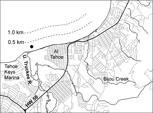
Discrete water samples were collected 250 m offshore of the outlet of the Upper Truckee River () during 14 of the spatial surveys. Samples were passed through a 0.1 micron millipore filter under pressure in the field. All samples were analyzed with the JEOL 840A scanning electron microscope (SEM) at the John McCormack Electron Microbeam Laboratory of the University of Nevada Reno. Filters were coated with palladium, which provided good imaging of the filter surface to visually examine particle composition and find areas appropriate for elemental analysis. A Kevex Quantum electron dispersive spectroscopy (EDS) detector was used to determine the relative elemental composition of particles present on at least 3 separate areas of the filter roughly 400 μm2 in size and containing only particles smaller than 2 um dia. Plots from EDS processing were analyzed by determining a baseline composition and measuring the presence of individual elements above that base.
Particles that could be morphologically identified under the SEM as diatoms, minerals, or organic material were also scanned with EDS to determine the relative elemental composition of the different types of particles. Diatoms were found to contain □75% silica, minerals contained □10% metals (primarily aluminum, iron and calcium) and □25% carbon, and organic material contained □75% carbon.
Results
The 23 spatial surveys captured seasonal trends and precipitation events that influenced clarity in Lake Tahoe near the City of South Lake Tahoe. These surveys are summarized by 5 examples of measurements collected at transects parallel to shore () and by the maximum distance from any point along that shoreline where elevated and high turbidity values were recorded (). The transects () exemplify typical spatial variation of turbidity in the localized nearshore area in response to seasonal changes and annual snowmelt runoff () in comparison to the overall trends in turbidity plumes for all dates ().
Figure 3 Transects of turbidity at 0.5 and 1.0 km offshore along 3.5 km between the outlet of the Upper Truckee River outlet and east of Bijou Creek South Lake Tahoe for 5 dates (see and ).
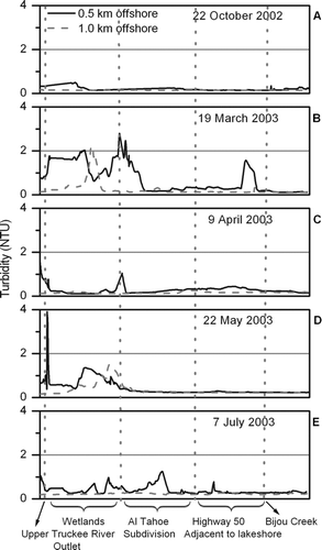
Figure 4 Upper Truckee River discharge recorded at the US Geological Survey gage (station number 10336610) in South Lake Tahoe (top). Distance in a perpendicular direction from the lakeshore where elevated and high turbidity values were recorded (bottom) during the study period July 2002–August 2003.
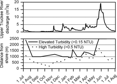
Table 1 Weather conditions preceding the 5 survey dates that were selected to exemplify typical, calm fall conditions, spring precipitation events, spring snowmelt, and calm summer conditions. This is a subset of the 23 surveys conducted in 2002 and 2003.
During the study period, the baseline nearshore and offshore turbidity for the South Lake Tahoe area was very low, at approximately 0.15 NTU. Calm fall conditions in September and October 2002 resulted in the highest overall clarity ( and ). Areas of elevated (>0.15 NTU) and high (>0.5 NTU) turbidity were largely restricted to the shallowest nearshore zone in the fall, with isolated patches of elevated turbidity recorded out to about 1 km offshore (). Snowfall at the lake level during the fall and early winter resulted in spikes in the extent of high turbidity areas in the nearshore area. The lag between fall snowfall events and observed increases in turbidity () was partly attributed to the lagtime between snowfall and when snowmelt entered the lake. Surveys were normally carried out 1–2 days after the precipitation event, when calmer winds allowed for boat travel on the lake.
Winter and early spring water clarity was largely driven by precipitation events. The 19 March 2003 rain-on-snow event was a good example (Fig 3b). Increases in Upper Truckee River flows, combined with urban runoff, resulted in high turbidity levels near the outlet of the river and offshore of Bijou Creek. A survey of the nearshore area 2 days after lake-level rain recorded a maximum turbidity of more than 3.9 NTU, with values of more than 2.5 NTU at 0.5 km from shore, and 2.2 NTU as far as 1.0 km from shore (). Colder precipitation events did not always produce an immediate effect on nearshore turbidity values, likely because the snow did not melt immediately and therefore did not increase tributary inflows ().
During spring snowmelt, the spatial extent and magnitude of elevated turbidity increased dramatically in response to much larger Upper Truckee River inflow ( and ). The elevated nearshore turbidity (>0.15 NTU) was most apparent directly adjacent to the Upper Truckee River outlet () and extended out past the end of the study area 2.5 km from shore, with areas of high turbidity (>0.5 NTU) as far as 1.7 km offshore (). During this time, a severe reduction in clarity was visibly apparent from the lakeshore. Although the area of high turbidity rapidly decreased as Upper Truckee River flows diminished, elevated turbidity areas continued to stretch to the limit of the study area throughout June.
Summer rainstorms resulted in only localized patches of high turbidity () similar to the conditions observed after spring precipitation events; however, the area of elevated turbidity was greater than that observed in spring. The wider area of elevated turbidity was possibly due to resuspension of sediments during the high winds that often accompany summer precipitation events or may have been a residual effect of snowmelt runoff. In general, areas of elevated and high turbidity were confined to the shallow area offshore South Lake Tahoe during July and August.
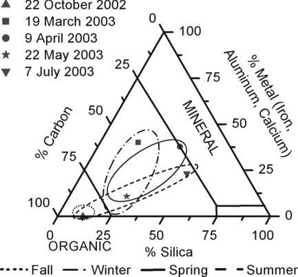
Results of discrete particle samples collected 250 m offshore suggested that during calm, fall conditions, when turbidity was lowest overall, the nearshore area was largely devoid of mineral particles (). However, during spring precipitation events and snowmelt runoff, areas of higher turbidity in the nearshore resulted from a mixture of mineral and organic particles. There was a continued mix of mineral and organic particles in this area in July, despite the reduction in Truckee River flow and areas of high turbidity. On 6 occasions, particle composition samples were also collected 3.0 km offshore of the Upper Truckee River outlet. These sampling dates included all seasons, including the peak of snowmelt runoff (22 May 2003) and after a late winter precipitation event (5 March 2003). The particle content of all of these samples collected farther from shore was nearly 100% organic, contrasting with the nearshore samples ().
Figure 5 Particle composition from water samples collected approximately 250 km offshore South Lake Tahoe (see ) on 5 dates described in . Samples composed of up to 25% silica and 75% carbon were considered organic material, while samples composed of 10% metals were of mineral origin. Seasonal circles were derived from the full set of 14 samples collected at this site. For clarity, only the samples from the dates in are shown.
Discussion
This study applied intensive and extensive turbidity measurements to assess patterns of water clarity not achievable by Secchi depth measurement or isolated turbidity assessments. This method is appropriate for nearshore as well as midlake measurement of water clarity, but is especially useful for shallow areas where Secchi depth readings are not possible. Turbidity measurements provide an unbiased method of comparing water clarity over time and in any conditions. While the established environmental thresholds for Lake Tahoe already include turbidity as the littoral zone water quality indicator (TRPA 2002), the methods developed in this study offer a relatively low-cost and time-effective way to collect several thousand measurements in only a few hours. This allows better definition of high turbidity plumes near inflows and tributaries, and the ability to monitor seasonal effects and the influence of precipitation events.
Seasonal variation in Lake Tahoe over a 1 year period from July 2002 to August 2003 was examined. Waters were clearest during the calm weather in the fall, with typical turbidity values of 0.15–0.17 NTU. In the winter and early spring, clarity was patchy, especially after precipitation events. Rain-on-snow events, in particular, caused decreased clarity and turbidity values of almost 4 NTU in the shallowest nearshore. Overall clarity was lowest in late spring during snowmelt as a function of turbid runoff, with elevated turbidity values observed over 2.5 km from shore. Turbidity returned to the baseline value of 0.15 NTU slowly during the summer months.
Strong winds often accompany winter and spring precipitation events, commonly occur in summer, and likely have an influence on the spatial extent of turbid waters. Although wind typically comes from the southwest along the southern shore of Lake Tahoe, large variations in wind direction and speed were observed across the study area, and not enough data were available to accurately describe the conditions associated with any particular event. CitationStrub et al. (1984) and CitationSteissberg et al. (2005) discuss patterns of wind forcing and the resulting transport of particles in Lake Tahoe and show that wind may play a role in the observed patterns of turbidity at South Lake Tahoe. A visual comparison of Upper Truckee River inflows and turbidity plumes suggests that stream input also effects turbidity in the nearshore (). The observed turbidity variation was likely due to a combination of wind forcing, water temperature gradients (as stream and lake waters mix in the nearshore), and the settling velocity of variously-sized particles as turbid river inflows move into the lake.
The results of this study agree well with previous investigations of the driving factors controlling clarity in similar water bodies. Several authors have described short-term reductions in the clarity of large water bodies after periods of heavy precipitation (CitationJohnstone and Robinson 1987, CitationLarson et al. 2007) and in response to natural inflow from tributaries (CitationVincent et al. 1984, CitationSchallenberg et al. 1999). However, to the authors’ knowledge no other studies document the seasonal responses of nearshore waters in mountain lakes in detail.
For management and restoration purposes, it is important to understand not only when onshore activities are influencing lake clarity, but also the kind of particles responsible for observed variability. Both organic and inorganic particulate matter cause light scattering in water. While some studies suggest that inorganic particles have a greater potential for reducing the clarity of water bodies (CitationBiggs and Davies-Colley 1990, CitationCerco and Moore 2001, CitationDavies-Colley and Smith 2001), others point to the important role of organic matter (CitationGunn et al. 2001, CitationJeppesen et al. 2005). A model developed for Lake Tahoe water clarity suggests that inorganic particles play a larger role than organic particulate matter in light scattering within the lake in general, especially in late spring during snowmelt (CitationSwift et al. 2006); however, a majority of annual phosphorus loading to the lake from streams also occurs during snowmelt (CitationForney et al. 2001), which, because Lake Tahoe is phosphorus limited (CitationJassby et al. 1995), likely leads to higher than usual organic material in the nearshore area at that time.
In our study, water samples collected 250 m from shore during the spring runoff period contained much higher levels of particulate matter in general. Our EDS analysis confirmed that a mixture of both organic and inorganic particles contributed to the reduced clarity observed in the nearshore waters of South Lake Tahoe during snowmelt and associated runoff. The same was true for late winter–early spring precipitation events, which elevated the amount of water and suspended materials entering the lake. The mineral content observed in summer may have consisted of very fine sediment remaining in suspension from snowmelt runoff due to a long settling time. Samples collected 3.0 km from shore typically had fewer particles when compared to samples collected 200 m from shore. The lack of inorganic particles in the samples collected farther from shore may have been due to settling because samples were collected only at the surface.
Current studies that use water clarity as an indicator focus on the impacts of introduced species of fish (CitationEggleton et al. 2004, CitationRowe 2007), zebra and quagga mussels (CitationAldridge et al. 2004, CitationBarbiero and Tuchman 2004, CitationEimers et al. 2005, CitationBinding et a. 2007, CitationQualls et al. 2007), climate change (CitationGunn et al. 2001), and urbanization (CitationGoldman 1989, CitationEimers et al. 2005). Often, the effects of these disturbances on water quality is most apparent in the shallow littoral areas, and an increased knowledge of spatial and temporal variation of water clarity in these areas would provide more effective management of impacted lakes. Although turbidity was the main variable followed in this study, other measurements such as temperature, light attenuation, conductivity, dissolved oxygen, fluorescence, and pH could easily be included in the monitoring system described in this study, allowing rapid surveys of water quality parameters across a relatively wide spatial extent in a short period of time. This method is appropriate for general use as a tool to better understand littoral zone processes in lakes and would also be useful as an early warning system. Development of the shoreline in pristine lakes such as Lake Tahoe can lead to adverse effects such as increased algal growth. By collecting such fine-scale water quality measurements over a wide area, lake managers would be able to predict where and when nearshore areas were suitable for algal growth or the establishment of invasive species, or detect sources of pollution from onshore point sources. In combination with other monitoring techniques such as periphyton monitoring (CitationLambert and Cattaneo 2008), this technique may provide an especially effective means of detecting lake water quality disturbances before degradation is detected in open, midlake waters.
Acknowledgments
Funding for this study was provided by the Lahontan District of the California Water Quality Control Board, the Nevada Division of State Lands, the Tahoe Regional Planning Agency and the Desert Research Institute. Special thanks to Dr. John McCormack for his help with the SEM, Bryan Little for GIS assistance, and to Dr. Laurel Saito for her encouragement and assistance in communication between continents.
References
- Aldridge , D C , Elliott , P and Moggridge , G D . 2004 . The recent and rapid spread of the zebra mussel (Dreissena polymorpha) in Great Britain . Biol Cons. , 119 : 253 – 261 .
- Barbiero , R P and Tuchman , M L . 2004 . Long-term Dreissenid impacts on water clarity in Lake Erie . J Great Lakes Res , 30 ( 4 ) : 557 – 565 .
- Biggs , B J and Davies-Colley , R J . 1990 . Optical properties of Lake Coleridge: the impacts of turbid inflows . New Zeal J Mar Fresh. , 24 : 441 – 451 .
- Binding , C E , Jerome , J H , Bukata , R P and Booty , W G . 2007 . Trends in water clarity of the Lower Great Lakes from remotely sensed aquatic color . J Great Lakes Res. , 33 : 828 – 841 .
- Buiteveld , H . 1995 . A model for calculation of diffuse light attenuation (PAR) and Secchi depth . Aquat Ecol. , 29 ( 1 ) : 1386 – 2588 .
- Cerco , C F and Moore , K . 2001 . System-wide submerged aquatic vegetation model for Chesapeake Bay . Estuaries. , 24 ( 4 ) : 522 – 534 .
- Davies-Colley , R J and Smith , D G . 2001 . Turbidity, suspended sediment, and water clarity: a review . J Am Water Resour Assoc. , 37 ( 5 ) : 1085 – 1101 .
- Davies-Colley , R J , Vant , W N and Smith , D G . 1993 . Colour and clarity of natural waters: science and management of optical water quality , New York , NY : Ellis Horwood .
- Eggleton , M A , Gido , K B , Matthews , W J and Schnell , G D . 2004 . Assessment of anthropogenic influences on littoral-zone aquatic communities of Lake Texoma, Oklahoma-Texas, USA . Ecohydrol Hydrobiol. , 2 : 103 – 117 .
- Eimers , M C , Winter , J G , Scheider , W A , Watmough , S A and Nicholls , K H . 2005 . Recent changes and patterns in the water chemistry of Lake Simcoe . J Great Lakes Res. , 31 : 322 – 332 .
- Forney , W , Richards , L , Adams , K D , Minor , T B , Rowe , T G , Smith , J L and Raumann , C G . 2001 . Land use change and effects on water quality and ecosystem health in the Lake Tahoe Basin, Nevada and California US Geological Survey Open File Report 01–418
- Goldman , C R . 1989 . Preserving a fragile ecosystem . Environment. , 31 ( 7 ) : 7 – 30 .
- Gunn , J M , Snucins , E , Yan , N D and Arts , M T . 2001 . Use of water clarity to monitor the effects of climate change and other stressors on oligotrophic lakes . Environ Monit Assess. , 67 : 69 – 88 .
- Hakanson , L . 2006 . The relationship between salinity, suspended particulate matter and water clarity in aquatic systems . Ecol Res. , 21 : 75 – 90 .
- Jassby , A D , Goldman , C R and Reuter , J E . 1995 . Long-term change in Lake Tahoe (California-Nevada, U.S.A.) and its relation to atmospheric deposition of algal nutrients . Arch Hydrobiol. , 135 ( 1 ) : 1 – 21 .
- Jassby , A D , Reuter , J E and Goldman , C R . 2003 . Determining long-term water quality change in the presence of climate variability: Lake Tahoe (U.S.A.) . Can J Fish Aquat Sci. , 60 : 1452 – 1461 .
- Jeppesen , E M , Søndergaard , J P , Jensen , K , Havens , O , Anneville , L , Carvalho , M F , Coveney , R , Deneke , M , Dokulil , B Foy , D . 2005 . Lake responses to reduced nutrient loading – an analysis of contemporary long-term data from 35 case studies . Freshwater Biol. , 50 : 1747 – 1771 .
- Johnstone , I M and Robinson , P W . 1987 . Light level variation in Lake Tutira after transient sediment inflow and its effect on the submersed macrophytes . New Zeal J Mar Fresh. , 21 : 47 – 53 .
- Kloiber , S M , Brezonik , P L and Bauer , M E . 2002a . Application of Landsat imagery to regional-scale assessments of lake clarity . Water Res. , 36 : 4330 – 4340 .
- Kloiber , S M , Brezonik , P L , Olmanson , L G and Bauer , M E . 2002b . A procedure for regional lake water clarity assessment using Landsat multispectral data . Remote Sens Environ. , 82 : 38 – 47 .
- Lambert , D and Cattaneo , A . 2008 . Monitoring periphyton in lakes experiencing shoreline development . Lake Reserv Manage. , 24 : 190 – 195 .
- Larson , G L , Hoffman , R L , McIntire , D C , Buktenica , M W and Girdner , S F . 2007 . Thermal, chemical, and optical properties of Crater Lake, Oregon . Hydrobiologia. , 574 : 69 – 84 .
- Olmanson , L G , Bauer , M E and Brezonik , P L . 2008 . A 20-year Landsat water clarity census of Minnesota's 10,000 lakes . Remote Sens Environ. , 112 : 4086 – 4097 .
- Qualls , T M , Dolan , D M , Reed , T , Zorn , M E and Kennedy , J . 2007 . Analysis of the impacts of the zebra mussel, Dreissena polymorpha, on nutrients, water clarity, and the chlorophyll-phosphorus relationship in Lower Green Bay . J Great Lakes Res. , 33 : 617 – 626 .
- Reuter , J E and Miller , W W . 2000 . “ Aquatic resources, water quality, and limnology of Lake Tahoe and its upland watershed ” . In Lake Tahoe Watershed Assessment , Edited by: Murphy , D D and Knopp , C M . 215 – 399 . Pacific Southwest Research Station, USDA Forest Service .
- Rowe , D K . 2007 . Exotic fish introductions and the decline of water clarity in small North Island, New Zealand lakes: a multi-species problem . Hydrobiologia. , 583 : 345 – 358 .
- Schallenberg , M , James , M , Wes , I H and Howard-Williams , C . 1999 . External forcing by wind and turbid inflows on a deep glacial lake and implications for primary production . New Zeal J Mar Fresh. , 33 : 311 – 331 .
- Schuster , S and Grismer , M E . 2004 . Evaluation of water quality projects in the Lake Tahoe Basin . Environ Monit Assess. , 90 : 225 – 242 .
- Steissberg , T E , Hook , S J and Schladow , S G . 2005 . Characterizing partial upwellings and surface circulation at Lake Tahoe, California–Nevada, USA with thermal infrared images . Remote Sens Environ. , 99 : 2 – 15 .
- Strub , T , Powell , T M and Abbott , M R . 1984 . Temperature and transport patterns in Lake Tahoe: satellite imagery, field data and a dynamical model . Verh. Internat Verein Limnol. , 22 ( 2 ) : 112 – 118 .
- Swift , T J , Perez-Losada , J , Schladow , S G , Reuter , J E , Jassby , A D and Goldman , C R . 2006 . Water clarity modeling in Lake Tahoe: linking suspended matter characteristics to Secchi depth . Aquat Sci. , 68 : 1 – 15 .
- [TRPA] Tahoe Regional Planning Agency . 2007 . 2006 Threshold Evaluation Report.http://www.trpa.org/default.aspx?tabid=168. Accessed 2 May 2010
- [USEPA] United States Environmental Protection Agency . 1999 . “ Turbidity methods & measurement ” . In Methods for Chemical Analysis of Water and Wastes http://www.epa.gov/safewater/mdbp/pdf/turbidity/chap_03.pdfAccessed 2 May 2010
- Vincent , W F , Gibbs , M M and Dryden , S J . 1984 . Accelerated eutrophication in a New Zealand lake: Lake Rotoiti, central North Island . New Zeal J Mar Fresh. , 75 : 431 – 440 .