Abstract
International cooperation between Canada and the United States is necessary to sustain water quality and quantity of numerous cross-border water bodies. We used Lake Memphremagog as a case study for highlighting how paleolimnological and historical research can be insightful in developing conservation plans for transboundary waters. To investigate how the lake and its phosphorus (P) input from agricultural activity in the watershed have changed over the past ∼100 years, we developed decadal-scale, diatom-based records from analyses of sediment cores taken from the south and northwest ends of the lake and calculated watershed agricultural P budgets from Canadian and US agricultural census data. Based on these analyses, we observed substantial changes in diatom flora over the past century, and our diatom-based P transfer function demonstrated that lake trophic state in both basins has substantially varied. Correlation analyses between our diatom-inferred P concentrations and watershed P budgets identified agricultural inputs of P as a significant driver of lake trophic state, particularly from the 1930s to the 1970s. Recent dynamics in lake-water P concentrations are no longer tracking agricultural P budgets; instead, they likely reflect P arising from urban activities and possibly the slow release of P that previously accumulated in watershed soils or lake sediments. Given the complex network of regulatory agencies responsible for Lake Memphremagog and its watershed, as well as lessons learned from a neighboring transboundary lake, we predict that future lake management will be most effective if collaborations among local conservation groups and regional to national government agencies are fostered.
Eutrophication is often caused by elevated phosphorus (P) exports from watershed land uses such as agriculture, logging, urban development, and other commercial activities (Carpenter et al. Citation1998). Once point sources of nutrient loading are mitigated, a key challenge in lake management is attracting the participation of stakeholders to control nonpoint nutrient inputs to downstream lakes and rivers. As such, watershed and lake management strategies are most likely to meet their goals if they involve the local community and are based on sound science (Dale et al. Citation2000). When a water body and its watershed span 2 countries, the unique environmental and socioeconomic goals for the shared water body can complicate coordinated management (Konisky Citation2008). Furthermore, water quality monitoring by agencies is often restricted to monitoring within each country, resulting in differences in record length, frequency, and detail. This lack of a holistic monitoring scheme makes it difficult to judge the effectiveness of an environmental management plan (Rivard-Sirois et al. Citation2005, RAPPEL 2006).
Cost-effective and ecologically plausible lake and watershed management plans are informed by an understanding of the long-term dynamics of the focal ecosystem (Reavie et al. Citation2006, Smol Citation2008). The impacts of catchment land uses on past lake-water quality are best elucidated when paleolimnological analyses are combined with historical census data (e.g., Umbanhowar et al. Citation2003). In this study, we combined such analyses with a consideration of the socioeconomic factors that influence Lake Memphremagog, which straddles the border between Quebec, Canada and Vermont, USA.
To better understand the effects of past land use activities on the dynamics of Lake Memphremagog, we reconstructed lake-water total phosphorus (TP) concentrations from 2 sites with different agricultural land-use histories over the past ∼100 years using subfossil diatom assemblages. To quantify the effects of one major source of P loading, we estimated the variation in agricultural P sources through time, which we compared to our paleolimnological estimates of past lake-water P dynamics. With this historical perspective and a comparison to a neighboring lake that has undergone cultural eutrophication, we developed recommendations for lake management.
Materials and methods
Study site
Lake Memphremagog is located in southeast Quebec and northern Vermont (; ), with 71% (1267 km2) of its watershed located in Vermont and 29% (513 km2) located in Quebec. In contrast, 73% of the lake is located in Quebec (VANR 2006). Lake Memphremagog is a glacially formed lake in the Northern Vermont Piedmont biophysical region characterized by calcareous bedrock (Parent and Occhietti Citation1999).
Table 1 Characteristics of lake morphology and watershed land use. Data not available marked n/a.
Figure 1 (a) Location of Lake Memphremagog in relation to nearby cities; (b) Lake Memphremagog and its watershed. The outline delineates the entire watershed; hatched areas represent Newport Bay subcatchment and Green Bay subcatchment; line represents the Canada–United States political boundary.
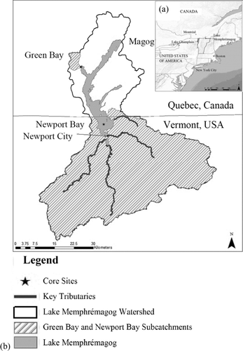
We chose Newport Bay and Green Bay as study sites to contrast basins with different land use. Newport Bay is located at the south end of the lake near Newport City, Vermont. Four main tributaries drain the Vermont watershed into Newport Bay, supplying 63% of the water to the lake (VANR 2006). Green Bay is partially isolated from the northwest section of the lake by a larger bay; 3 streams enter Green Bay via wetlands (wetland surface extent is 1.5% of the Green Bay subcatchment; Natural Resources Canada 1996).
The Newport Bay subcatchment is more developed relative to the Green Bay subcatchment. In 2000, the Newport Bay subcatchment had a population of 26,277, with about one-fifth of permanent residents living in Newport City (USFCB 1891–2001). Newport Bay's shoreline is extensively modified (i.e., ∼75% of the shoreline has been modified) for boating and tourism with the construction of artificial structures such as docks and impermeable surfaces (e.g., roads and boardwalks; RAPPEL 2006). Newport Bay receives waste from 3 municipal sewage treatment facilities, the first of which was installed in 1965. At present, 2 plants have primary sewage treatment and a third was upgraded to secondary sewage treatment in the 1990s (VTDEC 2010). In contrast, the subcatchment of Green Bay is sparsely populated with only 8% of the shoreline modified into large estates (USFCB 1891–2001, Rivard-Sirois et al. 2005). Most (89%) of the Green Bay watershed is currently forested (Natural Resources Canada 1996).
The watershed has experienced a succession of land use from agricultural and industrial activities to residential and commercial activities. Prior to European settlement, the region was covered with hardwood forest. The British established settlements in the 1780s (Nelson Citation1977). Industries included logging (1830–1850), copper and asbestos mining (1863–1949), and textile, paper, and iron factories (1900–1930s; Nelson 1977). From the 1930s to the 1990s, agriculture of hay, apples, and Christmas trees was the region's economic base, but it has recently been replaced by tourism (VANR 2006).
Agricultural P budget
We constructed historic agricultural P budgets for the entire Lake Memphremagog watershed and individual Newport Bay and Green Bay subcatchments (see Supplement A for raw data). Inputs include P contained in commercial agricultural fertilizers and in manure applied in the watershed (MacDonald and Bennett Citation2009). Manure P inputs were calculated based on the typical amount and P content of manure produced annually per animal (ASAE 2003, Lorimor and others Citation2000, Lander and others Citation1998) for the 5 major livestock species in this region. Fertilizer P inputs were estimated using provincial and state P fertilizer sales data (USDA-CRB 1954, 1959, 1969, 1982, Terry and Kirby Citation1992, Citation2003, Korol Citation2002) as well as county-level fertilizer expenditures reported in each census year. Outputs consist of P contained in harvested crops. Crop P outputs were calculated based on the amount of crops grown as indicated in the federal agricultural census data (every decade beginning in 1871 for Canada and 1901 for the United States; CDBS 1851–2002, USFCB 1891–2001), typical yield, and P content in the harvested portion of 14 major crops in this region (CFI 2001, CRAAQ 2003, USDA-NRCS 2005).
Paleolimnological analyses
To infer past lake-water TP concentrations, we conducted paleolimnological analyses of 2 sediment cores. Green Bay was sampled in summer 2006 and Newport Bay in September 2009. We collected sediment cores as close as possible to each bay's maximum depth (7 m in Newport Bay and 24 m in Green Bay) with a Glew et al. (Citation2001) gravity corer. Sediment was extruded in 0.5 cm (Newport Bay) or 1 cm (Green Bay) thick sections using an upright extruder (Glew Citation1988) then stored in Whirlpak bags and refrigerated prior to further analysis.
Sediment dating
Our sediment core chronology is based on a constant rate of supply (CRS) model (Binford Citation1990) applied to 210Pb, 214Pb and, 214Bi activities in 23 sediment intervals from Green Bay and 18 sediment intervals from Newport Bay. Sediment intervals were freeze-dried, ground, and packed and sealed in polypropylene tubes. After being sealed for at least 2 weeks, we measured the isotopic decay of each sample in a Canberra Well Detector Gamma Ray 120 Spectrometer for 24 h. Peak 137Cs activities known to occur in 1963 from atmospheric radionuclide fallout provided an independent age marker to assess the performance of our 210Pb dates (Supplement B).
Diatom analyses
Sedimentary diatom assemblages were enumerated and identified in each core to infer historic lake-water TP trends. Sediment subsamples were prepared according to standard methods (Battarbee Citation2001). For each slide, 400 diatom valves were identified and counted using a Leica DM 4500B microscope with oil immersion at 1000× magnification. Diatom taxonomy followed the Krammer and Lange-Bertalot (1986–1991) book series and publications on Quebec diatom taxa (Fallu et al. Citation2000, Lavoie et al. Citation2008).
Table 2 Estimates of P loads to Lake Memphremagog from agriculture and domestic sewage (kg/yr).
We applied a diatom transfer function developed by Moos et al. (Citation2009) to the sedimentary assemblages to reconstruct past TP trends in each bay. The transfer function was based on a calibration set of 268 lakes from western North America, many of which had a similar basin morphometry to Lake Memphremagog. We applied a weighted-averaging model to Newport Bay and Green Bay core data using the computer program C2 version 1.4.2 (Juggins 1991). The suitability of the transfer function to infer past surface water TP concentrations was evaluated by conducting a fit to TP analysis (e.g., Gregory-Eaves et al. Citation2003). In particular, we conducted a canonical ordination analysis in which we constrained the calibration set assemblages to water-column TP data. Fossil samples were then included in the ordination as passive sites and deemed as having poor fit with the calibration set if they fell outside the outer 95% confidence limit of first canonical correlation analysis (CCA) axis when constrained to TP. The diatom-inferred phosphorus (DI-TP) data were compared to the agricultural P budgets for each subcatchment and the entire watershed using the computer program SPSS version 14.0 (SPSS 2005).
Results and discussion
Historical and paleolimnological analysis of Newport Bay
Over the past ∼100 years, the Newport Bay record has shown a eutrophication trend that broadly corresponds to historical land use changes. In the early 20th century, the population in the Newport subcatchment (i.e., Orleans County) showed a pronounced rise; agricultural lands were established, and the Newport Bay watershed P inputs (420 metric tons P/yr) made up one-third to one-half of the agricultural P budget of the entire watershed (919 metric tons P/yr; ). Populations in the Newport subcatchment and across the entire lake's watershed reached a maximum in the 1920s, which likely increased various P sources associated with human settlement including land clearing, sewage, and agricultural and industrial activities (Nelson Citation1977). Based on our analysis of the Newport Bay sediment core, we noted a corresponding increase in DI-TP (bootstrapped r2 = 0.54; RMSEP = 0.34). Species like Fragilaria crotonensis, known to flourish in mesotrophic conditions, showed a rise in relative abundance (), suggesting a response in the diatom community to increased P loading from the watershed.
The agricultural P budget showed that the most intense period of agriculture was between the 1950s and 1980s. According to a previous P loading study by Spiller et al. (Citation1975), agriculture was the single largest source of P loading to Lake Memphremagog in the 1950s and 1960s (). From the 1950s to 1980s, excess P was applied to farmlands in the form of commercial P fertilizer and manure (VANR 2006). Consistent with the land-use data, we detected the highest DI-TP values during the 1950s. At this time, we noted a shift in the diatom assemblage to taxa associated with more eutrophic conditions, including Aulacoseira ambigua, Aulacoseira granulata, Fragilaria capucina, and Stephanodiscus minutulus (; Hall and Smol 1992, Reavie et al. 1995). DI-TP then decreased in the 1960s, matched by a decrease in the agricultural P budgets as well as the installation of the first sewage treatment plant in Newport City. Based on the compilation of several studies of P loading to Memphremagog, the installation of sewage treatment plants in Newport clearly resulted in a considerable decrease in P from domestic sewage over the past few decades ().
Figure 2 Historical and paleolimnological data from each of the study basins. Potential agricultural P loads (shaded = bay subcatchment, line = total watershed) were estimated from census data for basin subcatchments as well as for catchment of entire lake (note: in 1981, county boundaries changed substantially in Canada and thus we could no longer use this method to estimate P loads in the Green Bay subcatchment). Diatom-inferred TP (DI-TP) estimates are plotted as μg/L. Measured TP (μg/L) from water quality assessments and research are presented (Kalff 1970s, unpublished; Kalff and Lawson Citation1988, QVSC 2008). The dominant diatom taxa (i.e., species with >5% relative abundance) are plotted for (a) Newport Bay and (b) Green Bay over the past ∼135 years. +represents poor analog fit to TP.
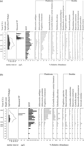
In the 1980s, Vermont implemented an agricultural remediation program along the 3 main tributaries located in Vermont. The program introduced beneficial management practices including the sequestration of manure, frugal use of P fertilizer, and regulations against applying manure to frozen ground; also, many farms were abandoned at this time (VANR 2006). Since the 1980s, the agricultural P budgets declined in the Newport Bay subcatchment (538 metric tons P/yr in 2001) and total lake watershed (1,511 metric tons P/yr; ). The DI-TP declined from 1965 through the 1980s, but the DI-TP has remained consistent (∼23 μg/L) from ∼1990 onward. We note that our recent DI-TP estimate is higher than the average summer TP (20 μg/L) reported based on limnological monitoring (QVSC 2008), but these data fall within the error estimates of our DI-TP results. Newport Bay did not return to its pre-1900 DI-TP levels, despite large decreases in potential agricultural P inputs. This may be related to the persistent release of P that has been stored in soils and lake sediments (Flett and Marshall Citation1983) and recent increases in shoreline construction for tourism and summer residences (RAPPEL 2006).
Historical and paleolimnological analysis of Green Bay
Green Bay sediments also recorded a trend of eutrophication with some recent recovery, albeit these changes are more subtle than those observed in the Newport Bay core. Before European settlement, Green Bay was relatively nutrient poor (DI-TP ∼12 μg/L), and the diatom assemblage was dominated by benthic species including Achnanthes lanceolata, Fragilaria tenera, and Fragilaria pinnata (). However, the DI-TP increased around the beginning of the 20th century, when Fragilaria crotonensis and mesotrophic subdominant taxa began to increase in relative abundances (). Unfortunately, the diatom flora from the most recent sediment interval from the Green Bay core does not have a good modern analog, thus we are less confident of the DI-TP values; nonetheless, we know that Green Bay is currently oligotrophic based on recent limnological sampling (average summer TP ∼9 μg/L; QVSC 2008). Throughout the historical record, the agricultural P budget of Green Bay subcatchment has been relatively low (mean of 326 metric tons over the full time series) but had peak values in 1951–1972 (431 metric tons), concurrent with the introduction and use of P fertilizer.
Figure 3 Correlation between DI-TP (measured in μg/L) and the lake watershed potential agricultural P load (kg P/ha/yr) for (a) Newport Bay (P = 0.00) and (b) Green Bay (P = 0.02).
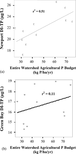
There is a modest but significant correlation between the DI-TP of the Green Bay core with the agricultural P budget of the total lake watershed (r2 = 0.11; P = 0.02; ). However, we did not detect a significant correlation between the DI-TP record and the agricultural P budget for the Green Bay subcatchment (r2 = 0.00, P = 0.16). We suggest that the Green Bay diatom assemblage is significantly correlated to P loaded from the total lake watershed because this is a much larger source of P loading than that derived from the Green Bay subcatchment. The Vermont proportion of the watershed, which is mostly in the Newport Bay subcatchment, is currently estimated to supply 65% of all P sources to the lake from a combination of agricultural and urban nutrient sources (MRC 2009). As such, the potential agricultural P load in the Newport Bay subcatchment likely overwhelms variation in nutrient run-off in the Green Bay subcatchment. The more subtle trophic change in the Green Bay sediment record compared to the Newport record may also be due to the different morphometries of these basins. Specifically, internal loading of P in Green Bay is likely less important because its basin is relatively deep and much less exposed compared to Newport Bay, and Green Bay has been observed to have an oxic hypolimnion at the end of summer (Gregory-Eaves, pers. observ.).
Applying science and local knowledge to manage a cross-border lake
Based on our analysis of historical and contemporary P dynamics in Lake Memphremagog, we suggest that effective reduction in P loading will require proactive measures taken by both Vermont and Quebec, focused on both the lake and watershed. For example, our analysis suggests that, even in the isolated Green Bay subcatchment, the impacts of agriculturally derived P from the Vermont portion of the watershed are detectable. As such, P regulation in Vermont could have an immediate and effective impact on the entire lake (MRC 2009). However, Vermont and Quebec input approximately equal amounts of P into the lake proportionate to the watershed area under their jurisdiction (MRC 2009), so Quebec is not without its own share of responsibility.
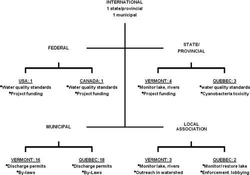
International collaboration is challenging given a complex regulatory framework (). For example, the federal governments regulate the navigable waters (often delegated to provincial/state authority), but the deep waters of the lake and the tributaries are regulated by provincial/state governments. In the case of Lake Memphremagog, however, there is a state/provincial level agreement (Environmental Cooperation Agreement on Managing the Waters of Lake Memphremagog 1989, 1993, Agreement on Managing Lake Memphremagog and its Watershed 2003) in addition to the 1909 Boundary Waters Treaty that guides federal water management issues. Through these agreements, as well as the work of nongovernmental organizations, both independent and collaborative efforts have initiated water monitoring, shoreline restoration, and public education projects.
Figure 4 Organizational chart representing the number of entities involved in the regulation of Lake Memphremagog at different levels of government and nongovernment organizations, with examples of responsibilities in regards to the conservation of Lake Memphremagog.
Such transboundary cooperation to manage the eutrophication of a water body is exemplified by Lake Champlain. A neighbor to Lake Memphremagog, Lake Champlain lies on the border between Quebec, Vermont, and New York. When Lake Champlain began to eutrophy, studies showed that 55% of the basin P load was agricultural (17% of land use) and 37% of the basin P load was urban (6% of land use; Hegmen et al. 1999). In response, a state/provincial government agreement determined a goal baseline of P load and committed each territory to reduce its P load. The governments agreed on a load-reduction strategy that was considered fair to each entity because of flexibility in targeting point and nonpoint sources based on the land use in each watershed area (VTDEC and NYSDEC 1994). The effort is overseen and funded in part by the US Environmental Protection Agency and the International Joint Commission. Local associations are involved in education and volunteer initiatives. More recent paleolimnological research has linked changes in trophic status indicators to agricultural and urban nutrient sources, as well as developed reference state targets (Levine et al. 2011). The efforts to reduce basin-wide P load have been successful, and further remediation is being constantly explored (LCBP 2008).
Based on our paleolimnological and historical analyses and interaction with the local community, we recommend a few key points to address in the development of management plans for Lake Memphremagog. We first suggest that land use management should focus on P input from urban sources like sewage and erosion (). Vermont in particular is poised to make a contribution to decreasing P input from urban sources because its portion of the watershed contains a much larger population. Second, international collaboration at local, municipal, state/provincial, and federal levels is indispensable for watershed-scale conservation initiatives, especially considering that Vermont and Quebec load the same amount of P proportionate to the land area under their separate jurisdictions. As exemplified by Lake Champlain, the development of joint international and individual state/provincial goals for P load and total maximum daily loads for point and nonpoint sources will be instrumental to conserving Lake Memphremagog, as is public education by collaborative local organizations. It is also clear from our analyses that some changes in the diatom assemblages cannot be explained by the agricultural P budgets, most notably the recent increase in Fragilaria crotonensis in both basins. These data suggest that other sources of environmental change, such as climate change, may be of growing importance and warrant future research.
Table 3 Estimated P inputs from recent land cover data (MRC 2009).
Fortunately, Lake Memphremagog does not yet face many of the water quality issues of Lake Champlain. Lake and watershed associations and state/provincial and municipal government departments focus on local education to reduce nonpoint P pollution to Lake Memphremagog. In particular, Quebec's Memphremagog Conservation Inc. and Vermont's Memphremagog Watershed Association represent a united effort of Vermont and Quebec watershed residents. Whereas Lake Champlain exemplifies international cooperation in lake remediation, hopefully Lake Memphremagog can become an example of international cooperation in lake conservation.
Conclusion
Lake and watershed management plans could gain from historical studies that quantify how the focal lake has responded to past land use activities. In the case of Lake Memphremagog, we found that sedimentary diatom assemblages and DI-TP of 2 subcatchments of Lake Memphremagog were significantly correlated to agricultural P budgets, although this pattern decoupled starting in the 1980s. Agricultural activities were a significant source of P for most of the 20th century, but agricultural inputs of P have declined substantially over the last 3 decades. However, DI-TP values have not returned to pre-European values which suggest that factors like urban activities and internal loading, as well as the slow release of P that has accumulated in agricultural soils, continues to enrich the ecosystem.
The variety of political regulatory bodies and scientific monitoring entities involved in the management of the Memphremagog watershed underlines the critical importance in collaboration within and between all levels of government and nongovernment bodies. Fortunately, the growing success of local lake and watershed associations and international councils at many government levels is a sign of the increased consciousness and willingness of United States and Canadian citizens to collaborate to conserve a lake that is fundamental for the economic vitality and cultural character of the Memphremagog region.
Acknowledgments
Funding for this project was supplied by the US-Canada Fulbright Commission, the Institute for International Education, the US State Department's Bureau of Education and Cultural Affairs, the Group for Interuniversity Research in Limnology and Aquatic Environment (GRIL), and NSERC. We also thank Graham MacDonald for providing the agricultural P budget data, Dr. Yves Prairie for providing historical lake water phosphorus data, and Tyler Hunt and Jesse Vermaire for conducting some preliminary research on the Green Bay core. Shauna Mahajan developed our map and Katherine Velghe, Guangjie Chen, and Zofia Taranu provided assistance with sampling, laboratory training, and statistical analyses. We thank Memphremagog Conservation, Inc., Memphremagog Watershed Association, and the Municipalité Régionale de Comté Memphremagog for giving interviews to understand the lake and its society. Finally, we thank Dr. Jacob Kalff and 3 anonymous reviewers for providing feedback on an earlier version of this manuscript. This project represents a contribution to Fulbright Canada's mission to enhance mutual understanding between the United States and Canada.
References
- Battarbee , RW. 2001 . “ Diatoms ” . Edited by: Smol , J P , Birks , H JB and Last , W M . Dordrecht: Kluwer 2001. Tracking environmental change using lake sediments. Vol. 3: Terrestrial, Algal, and Silicieous Indicators
- Binford , MW. 1990 . Calculation and uncertainty analysis of 210Pb dates for PIRLA project cores . J Paleolimnol. , 3 : 253 – 267 .
- [CDBS] . Ottawa , , Canada : Bureau of Statistics . Canada Dominion Bureau of Statistics. 1851, 1861, 1873, 1883, 1893, 1901, 1911, 1922, 1932, 1942, 1952, 1962, 1972, 1982, 1992, 2002, Census of population/ Census of agriculture bulletin
- [CFI] Canadian Fertilizer Institute . 2001 . Nutrient uptake and removal by field crops – Eastern Canada Ottawa Canadian Fertilizer Institute. http://www.cfi.ca/files/publications/archive/d160_NU_E_01.pdf
- Carpenter , S R , Caraco , N F , Correll , D L , Howarth , R W , Sharpley , A N and Smith , V H . 1998 . Nonpoint pollution of surface waters with phosphorus and nitrogen . Ecol Appl. , 8 : 559 – 568 .
- [CRAAQ] Centre de reference en agriculture et agroalimentaire du Québec . 2003 . Guide de référence en fertilisation. 1st edn , Sainte-Foy, Québec : Centre de reference en agriculture et agroalimentaire du Québec .
- Dale , V H , Brown , S , Haeuber , R A , Hobbs , N T , Huntly , N , Naiman , R J , Turner , M G and Valone , T J . 2000 . Ecological principles and guidelines for managing the use of land . Ecol Appl. , 10 ( 3 ) : 639 – 670 .
- Fallu , M-A , Allaire , N and Pienitz , R . 2000 . Freshwater diatoms from northern Québec and Labrador (Canada). Species-environment relationship in lakes of boreal forest, forest-tundra and tundra regions . Bibl Diatomol. , 45
- Flett , R J and Marshall , H . 1983 . Montreal , , Canada : Limnology Research Centre of McGill University; Report to Lake Memphremagog Project . The accumulation and distribution of phosphorus, organic, and inorganic matter in lake sediments as determined by lead-210
- Glew , JR. 1988 . A portable extruding device for close internal sectioning of unconsolidated core samples . J Paleolimnol. , 1 : 235 – 239 .
- Glew , J R , Smol , J P and Last , W M . 2001 . “ Sediment core collection and extrusion ” . Edited by: Last , W M and Smol , J P . 73 – 105 . Dordrecht , , Netherlands : Kluwer Academic Publishers . Tracking environmental change using lake sediments: basin analysis, coring, and chronological techniques
- Gregory-Eaves , I , Smol , J P , Douglas , M SV and Finney , B P . 2003 . Diatoms and sockeye salmon (Oncorhynchus nerka) population dynamics: Reconstructions of salmon-derived nutrients in two lakes from Kodiak Island, Alaska . J Paleolimnol , 30 : 35 – 53 .
- Hall , R I and Smol , J P . 1992 . A weighted-averaging regression and calibration model for inferring total phosphorus concentration from diatoms in British Columbia (Canada) lakes . Freshwater Biol. , 27 : 417 – 434 .
- Hegmen , W , Wang , D and Borer , C . 1999 . Estimation of Lake Champlain basin-wide phosphorus export . Lake Champlain Basin Program. , : 99
- Juggins , S. 2007 . 73 Newcastle upon Tyne , , UK : Newcastle University . C2 Version 1.5 User guide. Software for ecological and palaeoecological data analysis and visualisation
- Kalff , J and Lawson , A . 1988 . Montreal , , Canada : Limnology Research Center, Biology Department; McGill University . The capacity of Lake Memphremagog for further development
- Konisky , DM. 2008 . Bureaucratic and public attitudes toward environmental regulation and the economy . State Local Gov Rev. , 40 ( 3 ) : 139 – 149 .
- Korol , M. 2002 . Canadian Fertilizer Consumption, Shipments and Trade (2001/2002) , Ottawa : Farm Input Markets Units, Agriculture and Agri-Food Canada . http://www.agr.gc.ca
- Krammer , K and Lange-Bertalot , H . “ Bacillariophyceae ” . In Susswasserflora von Mitteleuropa 2/1–4 , Edited by: Ettl , H , Gerloff , J , Hyenig , H and Mollenhauer , D . 1986 – 1991 . Stuttgart , , Germany : Fischer .
- [LCBP] Lake Champlain Basin Program . 2008 . State of the Lake and Ecosystem Indicators Report – 2008 . : 32
- Lander , C H , Moffitt , D and Alt , K . 1998 . Nutrients available from livestock manure relative to crop growth requirements. Resource Assessment and Strategic Planning Working Paper No. 98-1. U.S. Department of Agriculture Natural Resources Conservation Service http://www.nrcs.usda.gov/technical/NRI/pubs/nlweb.htm
- Lavoie , I , Hamilton , P B , Campeau , S , Grenier , M and Dillon , P J . 2008 . Identification guide for diatoms of east Canada rivers. Presses de l’Université du Québec . French. ,
- Levine , S N , Lini , A , Ostrofsky , M L , Bunting , L , Burgess , H , Leavitt , P R , Reuter , D , Lami , A and Guilizzoni , P . 2011. The eutrophication of Lake Champlain's northeast arm: Insights from paleolimnological analyses . J Great Lakes Res , doi: 10.1016/j.jglr.2011.07.007.
- Lorimor , J , Powers , W and Sutton , A . 2000 . Manure characteristics. Mid West Plan Service MWPS-18-S1 Manure Management Series , 24 Ames (IA) : Iowa State University .
- MacDonald , G K and Bennet , E M . 2009 . Phosphorus accumulation in Saint Lawrence watershed soils: a century-long perspective . Ecosystems. , 12 : 621 – 635 .
- Moos , M , Laird , K and Cumming , B . 2009 . Climate-related eutrophication of a small boreal lake in northwestern Ontario: a paleolimnological perspective . Holocene. , 19 : 359 – 367 .
- [MRC] Municipalité Régionale de Comté Memphremagog . 2009 . Phosphorus transport model for the Lake Memphremagog watershed . French. , : 93
- Natural Resources Canada . 1996 . National Topographic Data Base sheet 31H01. Version 3.8. 1:50 000. Sherbrooke; [cited 5 May 2010] . Available from http://geogratis.cgdi.gc.ca/
- Nelson , EM. 1977 . Frontier crossroads: the evolution of Newport Vermont , Vol. 1 , 212 USA : Courier Printing Company .
- Parent , M and Occhietti , S . 1999 . Late Wisconsinan deglaciation and glacial lake development in the Appalachians of southeastern Québec . Geog Phys Quatern , 53 ( 1 ) : 117 – 135. .
- [QVSC] Quebec/Vermont Steering Committee on Lake Memphremagog . 2008 . The water quality of Lake Memphremagog: Results of the Joint Quebec-Vermont water quality monitoring initiative and recommendations for strategy development . : 44
- Reavie , E D , Hall , R I and Smol , J P . 1995 . An expanded weighted-averaging model for inferring past total phosphorus concentrations from diatom assemblages in eutrophic British Columbia (Canada) lakes . J Paleolimnol. , 14 : 49 – 67 .
- Reavie , E D , Neill , K E , Little , J L and Smol , J P . 2006 . Cultural eutrophication trends in three southeastern Ontario Lakes: A paleolimnological perspective . Lake Reserv Manage , 22 : 44 – 58. .
- [RAPPEL] Regroupement des associations pour la protection des lacs et des cours d’eau de l’Estrie et du haut basin de la Saint-Francois . 2006 . Operation Healthy Lake , Edited by: Rivard-Sirois , C and Pouet , M F . 178 Lake Memphremagog , Vermont : Sherbrooke .
- Rivard-Sirois , C , Brizard , H and Duteau , M . 2005 . Opération santé du lac (Operation Healthy Lake). Phase 1 Edited by: Pouet , M F and Bergeron , J M . 294
- Smol , JP. 2008 . Pollution of lakes and rivers: a paleoenvironmental perspective , 2nd ed. , Oxford , , UK : Blackwell Publishing .
- Spiller , G , Ruszczynski , T and Lands , M . 1975 . An estimate of the phosphorus loading of Lake Memphremagog (Quebec – Vermont) from a land-use study of the watershed , 65 Montreal , Canada : McGill University; Dept. of Biology; Limnology Research Group; Lake Memphremagog Project .
- SPSS . 2005 . SPSS for Windows, Rel. 14.0 , Chicago , IL : SPSS Inc. .
- Terry , D L and Kirby , B J . 1992 . Commercial fertilizers 1992 , Lexington (KY) : Association of American Plant Food Control Officials, Inc .
- Terry , D L and Kirby , B J . 2003 . Commercial fertilizers 2002 , Lexington (KY) : Association of American Plant Food Control Officials, Inc .
- Umbanhowar , C E , Engstrom , D R and Bergman , E C . 2003 . Reconstructing eutrophication and phosphorus loading for Lake Volney, Minnesota: Combining lake sediments and land use history to establish ‘natural’ baselines for management and restoration . Lake Reserv Manage. , 19 : 364 – 372 .
- “ [USDA-CRB] United States Department of Agriculture–Crop Reporting Board. 1954, 1959, 1969, 1982. Commercial fertilizers, consumption for year ended June 30 ” . Washington , DC : United States Department of Agriculture – Economics, Statistics and Cooperative Service .
- 2005 . “ [USDA-NRCS] United States Department of Agriculture–Natural Resources Conservation Service ” . Nutrient content of crops: nutrients removed by harvest. Crop Nutrient Tool. http://npk.nrcs.usda.gov/nutrient_body.html
- [USFCB] United States Federal Census Bureau . Population census/ agricultural census bulletin , Washington , DC : Bureau of Statistics . 1891, 1901, 1911, 1921, 1931, 1941, 1951, 1961, 1971, 1981, 1991, 2001
- [VANR] Vermont Agency of Natural Resources . 2006 . Basin 17: Lake Memphremagog watershed assessment report , 44 Government of Vermont; Agency of Natural Resources; Department of Environmental Conservation Water Quality Division .
- [VTDEC] Vermont Department of Environmental Conservation . 2010 . DEC watershed initiative , 32 Vermont Department of Environmental Conservation .
- [VTDEC and NYSDEC] Vermont Department of Environmental Conservation and New York State Department of Environmental Conservation . 1994 . Lake Champlain diagnostic-feasibility study. Final Report Draft 1 Jul 1994. A phosphorus budget, model, and load reduction strategy for Lake Champlain , VT : Waterbury .