
Abstract
Like other mountainous areas, Nepal is highly vulnerable to glacial lake outburst floods (GLOFs), and this vulnerability has increased due to climate change. Risk reduction strategies must be based on a comprehensive risk assessment. A comprehensive methodological approach for GLOF risk assessment is described and illustrated in case studies of the potential GLOF risk posed in Nepal by four glacial lakes, one located in China. People, property and public infrastructure (including hydropower plants, roads and bridges) are vulnerable, and there is a need to integrate GLOF risk reduction strategies into national policies and programmes.
Introduction
For as long as records have been available, high mountain areas are known to have experienced glacial lake outburst floods (GLOFs) – a form of flash flood in which water from a lake associated with a glacier is released suddenly, resulting in the outflow of a huge volume of water and sediment downstream. Such catastrophic flooding often results in serious loss of life and damage to property in downstream areas. Nepal, like many other mountainous countries, is highly vulnerable to GLOFs. At least 14 GLOF events have been identified as originating in the Nepal Himalayas, although the exact dates of some remain unknown, and a further 10 events originating in Tibet Autonomous Region, China, are known to have had an impact in Nepal (ICIMOD, Citation2011). The Dig Tsho outburst in 1985 and the Tampokhari outburst in 1998 both led to considerable loss of life, property and infrastructure and severely affected the livelihoods of the people living in downstream areas (Dwivedi, Acharya, & Simard, Citation2000; Vuichard & Zimmermann, Citation1987). The Ci-Ren-Ma-Co (Zhangzangbo) outburst of 1981, which originated in the Tibet Autonomous Region, caused extensive damage in downstream areas in Nepal. The Nepal-China Friendship Bridge, Arniko Highway, and Sunkoshi hydropower dam were damaged, and transport services were disrupted. The economic loss caused by this GLOF event alone was estimated at USD 3 million (ICIMOD, Citation2011).
The risk of GLOFs is heightened by climate warming, and the frequency of such events appears to be increasing (Richardson & Reynolds, Citation2000). The more rapid melting and recession of many Himalayan glaciers as a result of climate warming is leading to the formation of new glacial lakes and the enlargement of existing ones, increasing the risk of destabilization of the moraine dams (Cruz et al., Citation2007; van der Linden, Parry, Canziani, & Palutikof, Citation2007; Rosenzweig et al., Citation2007). GLOFs are often associated with high human mortality, and settlements in mountain regions will be at greater risk as the rate of glacier melting increases (Confalonieri et al., Citation2007; van der Linden et al., Citation2007). However, the risk can be reduced through development and implementation of appropriate mitigation and adaptation measures. For this, it is necessary to prepare a comprehensive assessment of GLOF hazard, risk and vulnerability. Attempts have been made to establish approaches, procedures, methods and guidelines for such an assessment (Carey, Huggel, Bury, Portocarrero, & Haeberli, Citation2012; Hegglin & Huggel, Citation2008; Huggel, Haeberli, Kääb, Bieri, & Richardson, Citation2004; McKillop & Clague, Citation2006; Mergili, Schneider, Worni, & Schneider, Citation2011; Reynolds Geo-Sciences Ltd, Citation2003; Schneider, Huggel, Cochachin, Guillén, & García, Citation2014; Wang, Yao, Gao, Yang, & Kattel, Citation2011; Worni, Huggel, & Stoffel, Citation2013). However, many of these methods rely heavily on remote sensing and GIS tools and do not include the direct field investigations needed for vulnerability and risk assessment.
A few detailed studies have been made of glacial lakes in Nepal, for example in the Hongu Valley (Byers, Mckinney, Somos-Valenzuela, Watanabe, & Lamsal, Citation2013), and a GLOF risk assessment has been made of the Imja glacial lake using bathymetry survey, ground-penetrating radar survey, and hydrodynamic modelling (Somos-Valenzuela, Mckinney, Byers, Rounce, & Portocarrero, Citation2013; Somos-Valenzuela, Mckinney, Byers, & Rounce, Citation2012; Somos-Valenzuela et al., Citation2012). These types of study provide the physical hazard assessment required as a basis for determining risk in the socio-economic vulnerability assessment.
The factors that influence GLOF risk and methodologies for risk reduction have been discussed by various authors. For example, Meon and Schwahz (Citation1993) discussed the criteria to be used for assessing damage and different models used for simulating GLOFs; Grabs and Hanisch (Citation1993) developed indicators for assessing GLOF risk and assessed different techniques for GLOF risk reduction; and Chalise, Shrestha, Budhathoki, and Shrestha (Citation2005) discussed different structural and non-structural measures to reduce GLOF risk. In Nepal, Yamada and Sharma (Citation1993) described past GLOF events and discussed the criteria to be used in assessing potentially dangerous glacial lakes, while Chikita and Yamada (Citation2005) discussed the mechanism of expansion of the Tsho Rolpa and Imja Lakes. More recently, Rodriguez (Citation2014) discussed risk reduction from dangerous glacial lakes based on extensive experience and knowledge acquired from active glacial lake management in the Cordillera Blanca, Peru.
Socio-economic vulnerability assessment is an important component of a comprehensive risk assessment. Alford (Citation2007) discussed the tools and techniques required for developing a risk management strategy in mountain areas in general, and highlighted the importance of preparing a socio-economic vulnerability assessment together with the hazard and physical risk assessment. But the procedures and methods for assessing vulnerability and estimating risk from potential GLOF events in downstream areas are scanty. The International Centre for Integrated Mountain Development (ICIMOD) has developed a comprehensive approach for assessment of GLOF hazard and risk which takes into account both the physical risk and the socio-economic vulnerability of potentially affected communities (ICIMOD, Citation2011). This article describes the approach and illustrates its application with a description of the results obtained in studies to assess GLOF hazard and risk related to four critical glacial lakes with potential impacts in Nepal. The studies illustrate the differences in risk posed by different socio-economic situations. The approach and the methods can be adapted for use across the Hindu Kush Himalayan region.
Methods
Approach
The step-by-step approach developed by ICIMOD for GLOF risk assessment and management in Nepal (ICIMOD, Citation2011) followed on from similar approaches used previously in the Hindu Kush Himalayan region (Ives, Citation1986; Ives, Shrestha, & Mool, Citation2010). In the past, assessment focused on physical risk and risk engineering; socio-economic vulnerability assessment is a more recent addition (ICIMOD, Citation2011). The methodologies for physical risk assessment are well established and documented, although still challenging. The following focuses on the methodology for assessing downstream vulnerability and the coping and adaptive capacity of the local population. A brief description of the methods used for each step is given below using the study of GLOF risk assessment studies in Nepal as an example; the approach is summarized schematically in Figure .
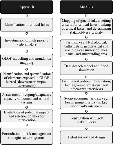
Identification and selection of critical glacial lakes
The first step is to identify which lakes might pose a risk, and of these, which should be prioritized for investigation. A detailed inventory of glacial lakes in Nepal was prepared in 2009/10 using Landsat images from 2005/06 as the main data source (ICIMOD, Citation2011), following an earlier study based mainly on topographic maps (Mool, Bajracharya, & Joshi, Citation2001). The Normalized Difference Water Index was used for automated glacial lake detection and complemented by visual interpretation. A digital elevation model and Google Earth were used for better visualization, especially for lakes in shadow and snow-covered areas. The inventory identified 1466 glacial lakes in Nepal, covering a total of 64.8 km2; of these, 21 were identified as critical (potentially dangerous) based on criteria related to such factors as the size and rate of growth of the lake; position in relation to moraines and associated glaciers; characteristics of the surrounding area (for example the presence of hanging glaciers in contact with the lake); condition of the dam (extent of crest, presence of an ice core, seepage); and physical condition of the surroundings (potential for rock falls and avalanches, presence of other lakes and moraines in tributary glaciers) (Ives et al., Citation2010).
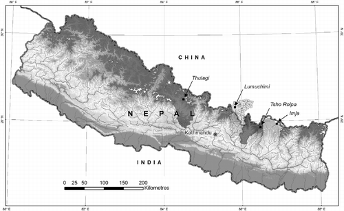
The critical lakes were further ranked and prioritized for field surveys based on physical and socio-economic criteria. The key physical parameters were the boundary conditions of the associated glaciers and lake enlargement over time; the distance between lake and glacier; the height, width and steepness of the moraine dams; the potential for rock and debris slides and avalanches; and the presence of hanging glaciers. The key socio-economic parameters were the size of downstream settlements, the number and type of bridges, the distance from hydropower projects, the area of agricultural land, and any other important infrastructure or activities of economic value that could be identified based on the secondary sources available. Based on these criteria, the critical lakes were divided into high priority (6), medium priority (4), and low priority (11) (Table ). Three of the six high-priority glacial lakes (Imja, Tsho Rolpa, and Thulagi) were selected for detailed field investigation and vulnerability assessment, together with Lumuchimi Lake, in the Poiqu Basin in China, as a representative lake in a transboundary basin, where an outburst would impact vulnerable settlements across the border in Nepal. The locations of the lakes are shown in Figure .
Table 1 Potentially dangerous lakes in Nepal, by priority.
Field investigation of critical lakes
Field investigations should include topographical and bathymetric mapping, hydro-meteorological observations, and geological, geophysical and glaciological surveys. Detailed field investigations of the high-priority lakes and their surroundings were conducted in 2008/09 (in Nepal only). Investigation of the stability of the moraine dam included a topographical survey of the moraine, the outlet, and the surrounding area, including changes in the lake shoreline and the position of the glacier terminus. The length, width and slope of the dam were measured, and the characteristics of the dam-forming materials were described qualitatively. The geological studies enabled an evaluation of the geological setting of the lake, glacier, moraine and surrounding area, as well as the composition of the moraine material. Geophysical investigation with ground-penetrating radar was used to locate buried ice. Geomorphological processes and landforms were also evaluated. A bathymetric survey using either direct depth measurement or echo-sounding was used to calculate the lake storage volume. Potential external GLOF triggers were evaluated by observation of the associated glacier for hanging glaciers, glacial retreat and other phenomena. The possibility of ice avalanche, ice calving, rock fall or rock slope failure was also assessed by observing the surrounding area. The hydro-meteorological investigation comprised measurements of discharge, flow velocity and cross-sectional area; recording of meteorological data such as air temperature, relative humidity, radiation, and wind speed and direction; and recording of hydraulic characteristics such as the steepness of the river, channel geometry, and seepage. Some of the data and information from the field investigations were used as inputs in the next step, GLOF modelling.
GLOF modelling and inundation mapping
The next step was to model the occurrence of a GLOF by simulating moraine dam failure and mapping the resultant inundation to assess the potential impact downstream. Thus, this included modelling the outburst scenario, modelling flood propagation, and mapping inundation. These sub-steps are illustrated schematically in Figure .
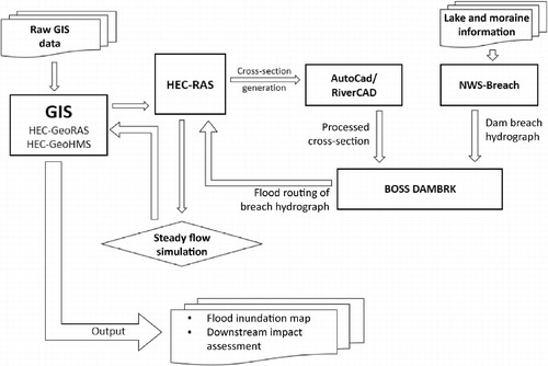
The Geospatial Hydrologic Modeling System model developed by the Hydrologic Engineering Center of the US Army Corps of Engineers (HEC-GeoHMS) was used to delineate catchments and generate streams and other hydrological inputs for the hydrological modelling system. The information was fed into the Hydrologic Engineering Center Geospatial River Analysis System (HEC-GeoRAS), an extension of ArcGIS software developed by the Environmental Systems Research Institute (ESRI), Redlands, California, to create a Hydrologic Engineering Center Geospatial River Analysis System (HEC-RAS) import file containing geometric attribute data from the existing digital terrain model and flow analysis. HEC-RAS (also developed by the Hydrologic Engineering Center of the US Army Corps of Engineers) can perform one-dimensional steady- and unsteady-flow water surface profile calculations. However, due to the steep terrain calculations, HEC-RAS was not stable, so the hydrodynamic analysis was first carried out using the BOSS DAMBRK model (an enhanced version of the NWS DAMBRK model) developed by BOSS International in Middleton, Wisconsin. For this, the NWS BREACH program was first used to estimate the breach outflow hydrograph (Fread, Citation1991), and this was used in BOSS DAMBRK to estimate the flood-wave travel time, time to flood stage, time to peak elevation, and the corresponding water surface elevations (Fread, Citation1998). The information was fed to HEC-RAS to create input files for HEC-GeoRAS. A digital elevation model of the area was derived from the NASA SRTM (National Aeronautics and Space Administration Shuttle Radar Topography Mission) digital elevation model. The input parameters for the model (such as lake surface area, maximum depth and top/bottom elevation, and dam information such as inside/outside slope, dam length and width, unit weight of dam materials, porosity of dam materials and diameter of particle size) were obtained from the field investigations for the three lakes in Nepal, and from secondary sources for the Lumuchimi glacial lake (Shrestha et al., Citation2010). Finally, HEC GeoRAS was used to create a flood inundation map.
Identification and quantification of elements exposed to a potential GLOF
The risk from a GLOF depends on the type and quantity of elements that will be exposed to inundation or its impacts; thus, the next step involves compiling information on the elements at risk. In the Nepal studies, this information was obtained through focus group discussions with local residents, key informant interviews, and transect walks and observation by the members of the research team.
The focus group discussions were organized in sections or blocks along the four rivers downstream of the lakes in the study, to the point downstream where each river joined another of similar size. The number of blocks was determined by the familiarity of the participants in the group discussions with the river reach. Twenty-three group discussions were held in the Dudhkoshi Basin (Imja Lake), 16 in the Tamakoshi Basin (Tsho Rolpa Lake), 12 in the Marsyangdi Basin (Thulagi Lake), and 10 in the Bhotekoshi/Sunkoshi Basin (Lumuchimi Lake); the groups had 7–12 participants. After the objective of the work and the inundation map prepared from model results were introduced, the participants in the group discussion were asked to map the details of elements in their areas likely to be affected by a potential GLOF. There are two effects related to a GLOF hazard: the primary effect resulting from inundation, erosion and sedimentation, up to the maximum calculated flood level; and a secondary effect resulting from slope failure that extends above the flood level. Experience from past GLOFs indicates that secondary effects can extend up to 35 m above the river bed where slopes are steep and unstable. Thus, the flood hazard zone was presented in two parts: the modelled flood level obtained from the dam break model; and the maximum affected level covering the area from the river bank up to 35 m above the river bed. Participants were asked to map the details of elements in both areas.
Topographic maps were used to guide the mapping exercise. A structured checklist was prepared to record the information covering (1) GLOFs and other flash-flood hazards and losses in the past; (2) exposed elements such as families, population, houses, land, crops, biodiversity and infrastructure; and (3) flow of vehicles, people, goods and services.
A unit-loss approach was adopted to estimate potential loss. First, the value of individual properties was calculated; these were then added together to derive a total potential loss figure. The estimated losses were grouped into four categories: direct damage to real estate (land and houses); indirect damage to agriculture (crops and livestock); direct damage to public infrastructure (roads, trails, bridges, schools, office buildings, temples, water mills, transmission lines, hydropower and others); and indirect secondary damage (such as loss of revenue from trade and hydropower, which are likely to be affected by damage to roads, bridges, and hydropower dams or power houses). Intangible losses were also discussed.
The local prevailing purchase values of household assets, including land, crops, livestock and others, and replacement cost of infrastructure, were used in estimating the monetary value of the elements exposed to a potential GLOF risk. Information on the per unit local prevailing purchase values was collected during the group discussions for each section/block. The national average cost per unit was used to estimate the replacement cost of bigger infrastructure such as roads and hydro-electric infrastructure. All values were based on the prices reported at the time of the fieldwork.
The study did not incorporate the potential loss of household property such as jewellery and ornaments, furniture, radio, TV sets, vehicles, and so on. It was not possible to obtain this information accurately in the focus group discussions; this would require a detailed household survey, which was not possible within the stipulated time and resources. It was also not possible to incorporate all the potential indirect tangible losses, such as in communications, health care, education services, utility supplies, income, emergency services, mitigation activities and increased household costs.
Assessment of coping/adaptive capacity of local people
Assessing risk also involves assessing the capacity of the local population to cope with or adapt to disaster. Less resilient communities are at higher risk of long-term negative impacts. In the Nepal study, information related to the vulnerability and adaptive capacity of the local population such as ethnicity, family type, level of education, landholding size, livelihood options, annual income, food sufficiency, social networking and institutions, indigenous knowledge, preparedness and mitigation strategies, and activities already undertaken was obtained in the focus group discussions. The questions were embedded in the structured checklist prepared for recording exposure.
Information about any activities recommended by local people for GLOF risk management was also collected during the discussions.
Results and discussion
GLOF modelling and inundation mapping
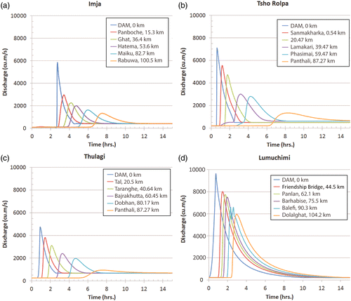
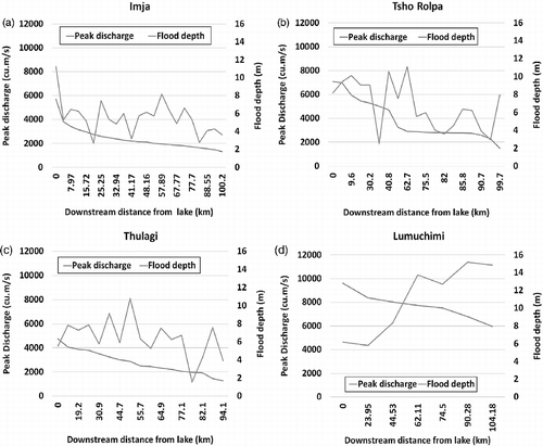
The flood stage, flood-wave travel time, time to flood stage, time to peak flood stage and the corresponding water surface elevations at downstream were calculated. The maximum flow and time for maximum flow to reach various locations are shown in Figure . The estimated maximum flow at the lake outlet ranged from 9611 m3/s for Lumuchimi (Ghimire & Misra, Citation2013) to 4736 m3/s for Thulagi. The estimated flood depth in the downstream area varies depending upon the morphology of the river channel. The values at selected cross-section sites are shown in Figure . The maximum flow depth at the outlet ranged from 11.25 m above normal for Imja to 5.52 m above normal for Thulagi.
Elements exposed to a potential GLOF
Land, people, and houses
A GLOF can have downstream impacts at four different levels: household, community, watershed and the nation as a whole. Households having property located within the potential GLOF hazard area are likely to be severely affected since they stand a high chance of loss and damage of lives and property. Households in the community nearby who use environmental resources such as water, forest, and grazing land, and infrastructure such as schools, office buildings, water mills, hydro-electricity, water supply schemes and irrigation canals, are likely to be highly affected because access to these resources and services will be blocked by damage to trails and bridges. Damage to infrastructure such as trails, roads and bridges disturbs the flow of people, goods and services; thus, people living in the whole watershed and other nearby districts are likely to be moderately affected. Finally, the power supply to the national grid may be cut if hydropower projects are damaged by a GLOF, and link roads for trade may be disrupted, which would affect people living in distant areas until electricity production resumes and the roads are reinstated.
The area of land (total and cultivated), number of people, and number of houses that would be inundated downstream of each lake under the modelled scenario (and maximum affected level) are given in Table .
Table 2 Land, people, and houses potentially affected by glacial lake outburst floods.
Crops
The major crops at risk from a GLOF are paddy, maize, potato, wheat and millet. The quantities (in tonnes) of different crops at risk under the modelled scenario and maximum affected level are shown in Table . The quantity varies markedly, from 114 t for Tsho Rolpa to 1415 t for Imja.
Table 3 Crops potentially exposed to glacial lake outburst floods (in tonnes).
Infrastructure
The infrastructure at risk includes schools, office buildings, temples, trails, roads, embankment structures, bridges, hydropower plants, irrigation canals, water mills and transmission lines. The infrastructure at risk under the modelled scenario and maximum affected level is shown in Table . A considerable number of schools, office buildings and transmission lines are at risk from Lumuchimi Lake, as is, most importantly, the Arniko Highway, which passes along the Bhotekoshi/Sunkoshi River valley linking China and Nepal. Hydropower plants are at risk from three of the four lakes.
Table 4 Infrastructure potentially exposed to glacial lake outburst floods.
Monetary value
The monetary value of the elements exposed to a GLOF risk is summarized in Table ; the share of different sectors in the total amount is shown in Figure . The total value at risk under the modelled GLOF scenario ranged from USD 1.85 million for Tsho Rolpa to USD 406.73 million for Thulagi. Public infrastructure and revenue accounted for the highest proportion of losses for both Thulagi and Lumuchimi; real estate was most important for Imja and Tsho Rolpa. The high monetary value of exposed elements for Thulagi is mainly due to the replacement cost of two big hydroelectric projects (Marsyangdi and Middle Marsyangdi) and the loss of revenue generated by these projects, while that for Lumuchimi is due to the Bhotekoshi, Sanima and Sunkoshi hydropower projects.
Table 5 Monetary value of elements potentially exposed to glacial lake outburst flood risk (USD thousands).
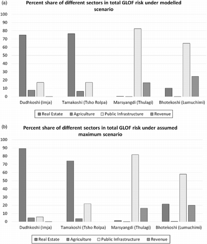
Figure shows the distribution of monetary value of elements exposed to potential GLOF risk from the source area to downstream for each of the lakes. The distribution depends on the level of infrastructural development and the distribution of human settlements. For example, the potential loss from a GLOF is higher in the downstream area for Tsho Rolpa and Thulagi, whereas it is higher in the upstream area for Imja and Lumuchimi.
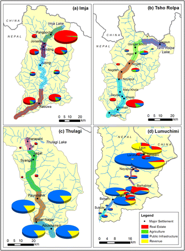
The level of exposure to a potential GLOF is comparatively higher in basins such as the Bhotekoshi/Sunkoshi and Marsyangdi where infrastructure is more highly developed. New settlements and market centres develop, and existing settlements and market centres expand, following the construction of a road, leading to greater risk. For example, the villages of Liping, Tatopani, Larcha, Barhabise, Lamosangu and Khandichaur have developed along the Kodari Highway in the Bhotekoshi/Sunkoshi Basin and are all at risk of a potential GLOF. The level of exposure could be reduced if proper attention were given to GLOF risk when selecting road alignment, and if land-use plans, building codes, and design standards for infrastructure development were introduced.
Many proposals have been submitted to the government of Nepal for developing hydro-electricity along the Marsyangdi, Tamakoshi, Dudhkoshi and Bhotekoshi/Sunkoshi Rivers. At the time of study, the amount of capital planned for hydroelectricity development projects was USD 8.98 billion for the Dudhkoshi, 2.4 billion for the Tamakoshi, and 2.2 billion for the Marsyangdi. These proposed hydroelectricity projects also face a degree of risk from potential GLOFs.
Livelihoods
In recent years, the flow of people and goods along these river valleys has been increasing due to the growth of tourism and trade, particularly along the Dudhkoshi (Imja), Marsyangdi (Thulagi), and Tamakoshi (Tsho Rolpa), following the opening up of a road for the Upper Tamakoshi hydroelectricity project. Annually, more than 30,000 tourists visit the Khumbu region in the Dudhkoshi Basin, and 16,000 visit the Dharapani area in the Marsyangdi Basin. Many porters are involved in carrying goods along the trekking routes, and many shops and hotels have been opened. The associated tourism, trade, and wage-based livelihood options for local people are likely to be affected to varying extents as a result of damage to trails and bridges in the event of a GLOF. Following the 1981 GLOF event in the Bhotekoshi/Sunkoshi Basin, trade and traffic flow were blocked for 36 days, and transport services between Barhabise and Kodari were disrupted for 3 years (Khanal, Banskota, Shrestha, Mool, & Acharya, Citation2013). Similarly, the Khumbu region was isolated for several days, and the weekly market at Namche did not function for three weeks due to damage to bridges and trails caused by the 1985 GLOF in the Dudhkoshi Basin. The average price of commodities increased by 50% (Ives, Citation1986; Vuichard & Zimmermann, Citation1986).
Coping/adaptive capacity of local people
Local people, particularly in the lower reaches, are not very aware of the GLOF risk. The lakes are located in remote high-altitude areas; people in the downstream area rarely if ever visit the lakes or perceive the danger.
Table shows the percentages of households with different degrees of vulnerability among total households residing in the areas directly susceptible to a potential GLOF for the three lakes in Nepal. A large proportion of the households are small farmers, do not have enough production to fulfil their food requirement, and have an annual household income of less than USD 1000, suggesting that the capacity of local people to cope with or adapt to the impact of a GLOF is rather weak.
Table 6 Percentage of households with different indicators of vulnerability in total households within areas susceptible to glacial lake outburst floods.
Of the total families residing in areas at risk for GLOF, more than 83% in Imja, 69% in Tsho Rolpa and 90% in Thulagi are of indigenous ethnic groups such as the Sherpa, Rai, Tamang, Magar, Thami and Gurung. Most of these groups are considered marginalized, highly marginalized, or disadvantaged, and because their level of development is generally low, their capacity for GLOF risk management is rather weak.
Mainstreaming GLOF risk reduction initiatives
Like all the Hindu Kush Himalayan countries, Nepal faces a range of disaster risks, as well as concern about the need to adapt to climate and other change. Most countries have a range of disaster risk reduction and climate adaptation programmes and activities; it is important to ensure that these are coordinated and that GLOF risk reduction is incorporated as one component.
The government of Nepal has prepared a National Adaptation Programme of Action for climate change. This is a strategic tool to assess climate vulnerability and systematically respond to climate change by developing and implementing appropriate adaptation measures. Monitoring of GLOF and disaster risk reduction is one of the prioritized activities identified for the country (Ministry of Environment, Citation2010). The activities proposed for reducing GLOF risk include monitoring of glacial lakes, developing of early-warning systems, enhancing institutional capacity, assessing hazards, developing contingency plans, and initiating of GLOF and disaster-related research and development. The government has also endorsed a national framework on Local Adaptation Plans of Action which provides guidelines and tools for the formulation and implementation of such plans in an integrated manner (GoN, Citation2011).
A few mitigation and adaptation measures have already been carried out to reduce the risk of a GLOF from the Tsho Rolpa. These include lowering the lake water level through test siphoning, constructing of an open channel, and establishing an early-warning system. The channel construction successfully lowered the lake level by 3 m. The early-warning system consisted of 19 automatic sirens at 18 villages, with 3 relay stations, covering major settlements with GLOF risk along the Rolwaling/Tamakoshi Valley to Rajgaon, about 100 km downstream (DHM, Citation2003). However, the system only worked for 4 years; the batteries and solar panels were taken from almost all the stations during the insurgency, and the system collapsed. A micro-hydropower plant with 15 kW installed capacity has been constructed to use the water discharge from the artificial channel at the outlet of Tsho Rolpa, but it is not functioning at full capacity; the power is used only for the project.
With support from the Global Environmental Fund and the UNDP, the Department of Hydrology and Meteorology recently initiated a project for Imja glacial lake to reduce the GLOF risk by lowering the lake level and establishing a community-based early-warning system. No risk reduction activities have been started at Thulagi Lake, but the Tal settlement is at high risk from a potential GLOF and there is a strong demand from local people for risk reduction activities. People from both Dingboche and Tal prefer lowering the water level of the lakes to installing early-warning systems. People from Dingboche are particularly keen to participate and contribute to lake lowering through construction of an open channel, and want to develop hydropower using the water discharge. The electricity could easily be supplied to the hotels and lodges in Chhukhung and Dingboche, which would also help in developing tourism activities in this area.
Conclusion
The risk of GLOFs has been increasing not only in high mountain areas but also far downstream. Thus, there is an urgent need for a comprehensive assessment of GLOF hazard, risk and vulnerability using sound methodological approaches. The study clearly shows that people living downstream of the four glacial lakes are at risk from GLOFs. Their lives and property, including public infrastructure, are vulnerable. Given the high vulnerability, there is an urgent need to take measures to prevent damage. Inaction or delay could result in a huge loss of life and economic and environmental damage, even far downstream.
The case studies identified a series of intervention strategies and activities for reducing the loss of lives and property, including regular monitoring of glacial lakes and assessment of the probability of outburst flood; lowering the water level of critical lakes; development and implementation of guidelines for land use and infrastructure development, and introduction of building codes for human settlement and market town development; and establishment of appropriate early-warning systems. Enhancement of the coping and adaptive capacity of local governments and communities, and raising awareness of GLOF risk, are necessary for effective operation of early-warning systems and preparedness planning.
There is a need to integrate disaster risk considerations in general and GLOF risk in particular into national and regional development plans, policies and programmes, including market town and infrastructure development; to establish a National GLOF Risk Management Alliance to make a concerted effort, mobilize resources and design appropriate response measures; to develop a unified database and information-dissemination system; to develop appropriate mechanisms for monitoring and strengthening early-warning systems; and to establish a GLOF Risk Reduction Fund for research, awareness creation, and the design and implementation of mitigation and adaptation measures. These efforts need to be integrated into the wider activities related to national development, disaster risk reduction and climate adaptation.
Disclosure
No potential conflict of interest was reported by the author(s).
Acknowledgements
The authors are grateful to the ICIMOD colleagues, professionals of collaborating institutions, and independent experts who all provided significant contributions during various phases of the studies undertaken.
Funding
This article is based on the results of case studies completed in 2010. Those case studies were supported by the World Bank, the Swedish International Development Cooperation Agency (Sida) and the US Agency for International Development, Office for Foreign Disaster Assistance. It was also supported by core funds from ICIMOD, contributed by the governments of Afghanistan, Australia, Austria, Bangladesh, Bhutan, China, India, Myanmar, Nepal, Norway, Pakistan, Switzerland and the United Kingdom.
References
- Alford, D. (2007). Risk management and sustainable development in the mountains of Central Asia, 1–10. Retrieved from http://www.mtnforum.org/content/risk-management-and-sustainable-development-mountains-central-asia.
- Byers, A. C., Mckinney, D. C., Somos_Valenzuela, M. A., Watanabe, T., & Lamsal, D. (2013). Glacial lakes of the Hongu valley, Makalu Barun National Park and Buffer Zone, Nepal. Natural Hazards, doi:10.1007/s11069-013-0689-8.
- Carey, M., Huggel, C., Bury, J., Portocarrero, C., & Haeberli, W. (2012). An integrated socio-environmental framework for glacier hazard management and climate change adaptation: lessons from Lake 513, Cordillera Blanca, Peru. Climatic Change, 112, 733–767. doi:10.1007/s10584-011-0249-8.
- Chalise, S. R., Shrestha, M. L., Budhathoki, K. P., & Shrestha, M. S. (2005). Glacio-hydrological aspects of climate change in the Himalayas: Mitigation of glacial lake outburst flood in Nepal. In T. Wagener, S. Franks, H. V. Gupta, E. Bogh, L. Batidas, C. Nobre, & C. D. O. Galvao (Eds.), Regional hydrological impacts of climate change - impacts assessment and decision making (Proceedings of Symposium s6 held during the seventh IAHS Scientific Assembly at Foz do Iquacu, Brazil, April 2005) (pp. 309–316). IAHS Publication No. 295. Wallingford: International Association of Hydrological Sciences (IAHS).
- Chikita, K., & Yamada, T. (2005). The expansion of Himalayan glacial lakes due to global warming: Field observations and numerical simulation. In T. Wagener, S. Franks, H. V. Gupta, E. Bogh, L. Batidas, C. Nobre, & C. D. O. Galvao (Eds.), Regional hydrological impacts of climate change - imacts assessment and decision making (Proceedings of Symposium s6 held during the seventh IAHS Scientific Assessmbly at Foz do Iquacu, Brazil, April 2005) (pp. 111–119). IAHS Publication No. 295. Wallingford: International Association of Hydrological Sciences (IAHS).
- Confalonieri, U., Menne, B., Akhtar, R., Ebi, K. L., Hauengue, M., Kovats, R. S., & … Woodward, A. (2007). Human health. In M. L. Parry, O. F. Canziani, J. P. Palutikof, P. J. van der Linden, & C. E. Hanson (Eds.), Climate change 2007: Impacts, adaptation and vulnerability, contribution of working group II to the fourth assessment report of the intergovernmental panel on climate change (pp. 391–431). Cambridge, UK: Cambridge University Press.
- Cruz, R. V., Harawawa, H., Lal, M., Wu, S., Anokhin, Y., Punsalmaa, B., & … Ninh, N. H. (2007). Asia. In M. L. Parry, O. F. Canziani, J. P. Palutikof, P. J. van der Linden, & C. E. Hanson (Eds.), Climate change 2007: Impacts, adaptation and vulnerability, contribution of working group II to the fourth assessment report of the intergovernmental panel on climate change (pp. 469–506). Cambridge, UK: Cambridge University Press.
- DHM. (2003). Project completion report of Tsho Rolpa GLOF risk reduction project. Kathmandu: Department of Hydrology and Meteorology, Government of Nepal.
- Dwivedi, S. K., Acharya, M. D., & Simard, R. (2000). The Tamp Pokhari glacier lake outburst flood of 3 September 1988. Journal of Nepal Geological Society, 22, 539–546.
- Fread, D. L. (1991). Breach: An erosion model for earthen dam failures. Silver Spring, MD: National Weather Services.
- Fread, D. L. (1998). NWS FLDW AV model: Theoretical description. Silver Spring, MD: National Weather Services.
- Ghimire, P., & Misra, B. (2013). Lumu Chimi Lake, Poiqu/Sun Koshi Basin, China and Nepal: Glacial lake outburst flood modelling. In A. B. Shrestha & S. R. Bajracharya (Eds.), Case studies on flash flood risk management in the Himalayas: In support of specific flash flood policies (pp. 37–41). Kathmandu: ICIMOD.
- GoN. (2011). National framework on local adaptation plans for action. Kathmandu: Government of Nepal, Ministry of Science, Technology and Environment.
- Grabs, W. E., & Hanisch, J. (1993). Objectives and prevention methods for glacier lake outburst floods (GLOFs). In G. J. Young (Ed.), Snow and glacier hydrology (Proceedings of the Kathmandu Symposium, Nov. 1992) (pp. 341–352). IAHS Publication No. 218. Wallingford: International Association of Hydrological Sciences (IAHS).
- Hegglin, E., & Huggel, C. (2008). An integrated assessment of vulnerability to glacial hazards. Mountain Research and Development, 28, 299–309. doi:10.1659/mrd.0976.
- Huggel, C., Haeberli, W., Kääb, A., Bieri, D., & Richardson, S. (2004). An assessment procedure for glacial hazards in the Swiss Alps. Canadian Geotechnical Journal, 41, 1068–1083. doi:10.1139/T04-053.
- ICIMOD. (2011). Glacial lakes and glacial lake outburst floods in Nepal. Kathmandu: International Centre for Integrated Mountain Development (ICIMOD).
- Ives, J. D. (1986). Glacial lake outburst floods and risk engineering in the Himalaya. Kathmandu: ICIMOD.
- Ives, J. D., Shrestha, R. B., & Mool, P. K. (2010). Formation of glacial lakes in the Hindu Kush-Himalayas and GLOF risk assessment. Kathmandu: ICIMOD.
- Khanal, N. R., Banskota, K., Shrestha, A. B., Mool, P., & Acharya, C. P. (2013). Bhote Koshi/Sun Koshi River, Nepal: Potential GLOF risk assessment and management. In A. B. Shrestha & S. R. Bajracharya (Eds.), Case studies on flash flood risk management in the Himalayas: In support of specific flash flood policies (pp. 12–17). Kathmandu: ICIMOD.
- McKillop, R. J., & Clague, J. J. (2006). A procedure for making objective preliminary assessments of outburst flood hazard from moraine-dammed lakes in southwestern British Columbia. Natural Hazards, 41, 131–157. doi:10.1007/s11069-006-9028-7.
- Meon, G., & Schwahz, W. (1993). Estimation of glacier lake outburst flood and its impact on a hydro project in Nepal. In G. J. Young (Ed.), Snow and glacier hydrology (Proceedings of the Kathmandu Symposium, Nov. 1992) (pp. 341–352). IAHS Publication No. 218. Wallingford: International Association of Hydrological Sciences (IAHS).
- Mergili, M., Schneider, D., Worni, R., & Schneider, J. F. (2011). Glacial lake outburst floods in the Pamir of Tajikistan: Challenges in prediction and modelling. Italian Journal of Engineering Geoloy and Environment, 973–982. doi:10.4408/IJEGE.2011-03.B-106.
- Ministry of Environment. (2010). National adaptation programme of action to climate change. Kathmandu: Government of Nepal, Ministry of Environment.
- Mool, P., Bajracharya, S. R., & Joshi, S. P. (2001). Inventory of glaciers, glacial lakes, and glacial lake outburst floods: Monitoring and early warning systems in the Hindu Kush-Himalayan region – Nepal. Kathmandu: ICIMOD.
- Reynolds Geo-Sciences Ltd. (2003). Development of glacial hazard and risk minimisation protocols in rural environments: Guidelines for the management of glacial hazards and risks. Nercwys, UK: Reynolds Geo-Sciences Ltd. Retrieved from www.bgs.ac.uk/research/international/DFID-KAR/ADD048_COL.pdf.
- Richardson, S. D., & Reynolds, J. M. (2000). An overview of glacial hazards in the Himalayas. Quaternary International, 65/66, 31–47.
- Rodriguez, C. A. P. (2014). The glacial lake handbook: reducing risk from dangerous glacial lakes in the cordillera blanca, peru. Washington DC: USAID, Global Climate Change Office, Climate Change Resilient Development Project. Retrieved from http://pdf.usaid.gov/pdf_docs/PBAAA087.pdf.
- Rosenzweig, C., Casassa, G., Karoly, J., Imeson, A., Liu, C., Menzel, A., & … Tryjanowski, P. (2007). Assessment of observed changes and responses in natural and managed systems. In P. J. van der Linden, C. E. H. M. L. Parry, O. F. Canziani, & J. P. Palukof (Eds.), Climate change 2007: Impacts, adaptation and vulnerability. Contribution of working group II to the fourth assessment report of the intergovernmental panel on climate change (pp. 79–131). Cambridge, UK: Cambridge University Press.
- Schneider, D., Huggel, C., Cochachin, A., Guillén, S., & García, J. (2014). Mapping hazards from glacier lake outburst floods based on modelling of process cascades at Lake 513, Carhuaz, Peru. Advances in Geosciences, 35, 145–155. doi:10.5194/adgeo-35-145-2014Ltd.
- Shrestha, A. B., Eriksson, M., Mool, P., Ghimire, P., Mishra, B., & Khanal, N. R. (2010). Glacial lake outburst flood risk assessment of Sun Koshi basin, Nepal. Geomatics, Natural Hazards and Risk, 1, 157–169. doi:10.1080/19475701003668968.
- Somos-Valenzuela, M. A., Mckinney, D. C., Byers, A. C., & Rounce, D. R. (2012). Bathymetric Survey of Imja lake, Nepal in 2012. CRWR Online Report 2012-6. Retrieved from http://www.crwr.utexas.edu/reports/2012/rpt12-6.shtml.
- Somos-Valenzuela, M. A., Mckinney, D. C., Byers, A. C., Rounce, D. R., & Portocarrero, C. (2013). Modeling Mitigation Strategies for Risk Reduction at Imja Lake, Nepal. CRWR Online Report 2013-6. Retrieved from http://www.crwr.utexas.edu/reports/2013/rpt13-6.shtml.
- Somos-Valenzuela, M., Mckinney, D. C., Byers, A. C., Voss, K., Moss, J., & Mckinney, J. C. (2012). Ground Penetrating Radar Survey for Risk Reduction at Imja Lake, Nepal. CRWR Online Report 2012-3. Retrieved from http://www.crwr.utexas.edu/reports/2012/rpt12-3.shtml.
- IPCC. (2007). In P. J. van der Linden, C. E. H. M. L. Parry, O. F. Canziani, & J. P. Palutikof (Eds.), Climate change 2007: Impacts, adaptation and vulnerability. Contribution of working group II to the fourth assessment report of the intervovernmental pannel on climate change (p. 976). Cambridge, UK: Cambridge University Press.
- Vuichard, D., & Zimmermann, M. (1986). The Langmoche flash-flood, Khumbu Himal, Nepal. Mountain Research and Development, 90–94. Retrieved from http://www.jstor.org/stable/3673345.
- Vuichard, D., & Zimmermann, M. (1987). The 1985 catastrophic drainage of a moraine-dammed lake, Khumbu Himal, Nepal: Causes and consequences. Mountain Research and Development, 7, 91–110.
- Wang, W., Yao, T., Gao, Y., Yang, X., & Kattel, D. B. (2011). A first-order method to identify potentially dangerous glacial lakes in a region of the southeastern Tibetan Plateau. Mountain Research and Development, 31, 122–130.
- Worni, R., Huggel, C., & Stoffel, M. (2013). Glacial lakes in the Indian Himalayas – from an area-wide glacial lake inventory to on-site and modeling based risk assessment of critical glacial lakes. The Science of the Total Environment, 468–469, Su, S71–84.10.1016/j.scitotenv.2012.11.043.
- Yamada, T., & Sharma, C. K. (1993). Glacier lakes and outburst floods in the Nepal Himalaya. In G. J. Young (Ed.), Snow and glacier hydrology (Proceedings of an International Symposium held at Kathmandu, Nepal, 16-21 November 1992) (pp. 319–330). IAHS Publication No. 218. Wallingford: International Association of Hydrological Sciences (IAHS).