
Abstract
This article proposes a systematic analysis of water management and allocation on the scale of a river basin, considering climate impacts and stakeholder networks in the Dongjiang River basin in South China. Specific approaches are integrated to explore various subtopics. Findings indicate a slight increase of precipitation in the basin and strong fluctuations in this century due to climate extremes, which may lead to seasonal or quality-related water shortages. It is highlighted that alternative options for holistic water management are needed in the basin, and participatory water allocation mechanisms and establishment of a basin-wide management framework could be helpful.
Introduction
One of the major impacts of climate change is related to hydrological variations. For instance, precipitation, evaporation, runoff and soil moisture content will be changed in terms of time, distribution, duration and extent (Wu, Christidis, & Stott, Citation2013). These factors are expected to lead to further changes in water quantity and deterioration of water quality. Water-related climate change impacts have been experienced widely in the form of more severe and frequent droughts and floods (Hirabayashi et al., Citation2013; Zhang, Xiao, Singh, & Chen, Citation2013). These changes induce redistribution of water resources in time and space, posing significant challenges for the existing water resource management system and social development.
In some developing countries, water shortages are aggravated by both climate change and human activities (Schewe et al., Citation2014; Vörösmarty, Green, Salisbury, & Lammers, Citation2000). Water shortage is a serious challenge especially to river basin management, as the water resource is shared by various stakeholders. Integrated basin-scale water resources management is usually complex, especially in the trans-boundary context, merging river tributaries across different political jurisdictions of countries, provinces, cities and districts. This is related to the management of complex hydrological characteristics, which often cross several layers of social, political, and economic institutions (Berger, Birner, McCarthy, Diaz, & Wittmer, Citation2007). For example, in a small basin where all the stakeholders are administered by a central government, water competition may still exist, owing to an overall water shortage from unbalanced freshwater supply and demand. Likewise, the issue may be relatively complex due to conflicts from injustice or uneven distributions of socio-economic benefits among stakeholders in upstream and downstream parts of the river basin. In developing countries where river basins are particularly prioritizing rapid social-economic development, increasing the need for water resources to cope with the pace of development, pressures and conflicts in water allocation among stakeholders are critically increasing (Shen & Wu, Citation2016). Indeed, in the poor countries which have always been facing hydrologic variability (e.g. inconsistent discharge, precipitation, water quality, etc.), the situation is becoming more difficult due to climate change, and directly making water management more costly (Gleick, Citation2014).
Recently, numerous studies on water allocation in the Dongjiang River basin, South China, have been done and greatly enhanced water management in the area (Chen, Chen, & Lai, Citation2002; Liu et al., Citation2012; Zhou et al., Citation2015). However, climate change and its influence on water allocation are still not fully understood (Yang, Scheffran, Qin, & You, Citation2015). Climate-related water pollution is rarely considered in the basin, as existing practices and research have mostly focused on sewage from industrial, agricultural and domestic sources (Chu, Hipel, Fang, & Wang, Citation2015). Regarding the significance of climate change impacts on the river system, it is necessary to explore the seasonal and quality-based issues of water allocation in the context of global and regional climate change, especially in rapidly developing areas. The uneven spatial and temporal distribution of water resources, together with serious river water pollution, often results in seasonal and quality-based water shortages (Tingey-Holyoak, Burritt, & Pisaniello, Citation2013). Therefore, a rational water allocation scheme must pay close attention to managing both water quantity and water quality.
In view of this background, the major aims of this study are: (1) to understand how climate change challenges river water management and (2) to identify suitable water allocation strategies to respond to the challenges. This study integrates impacts of climate change and hydrological changes in the Dongjiang basin and options for water management and allocation into a complete causal chain, to provide a comprehensive assessment of the water issues in the context of global climate change. Going beyond previous approaches, stakeholder analysis was used to support rational use of water in the basin, considering its relevance for water allocation, pollution control, eco-environmental protection and economic development.
Case study area: the Dongjiang River basin
The Dongjiang River (DjR, also known as East River in English) is one of the three major branches of the Pearl River (Zhujiang) in Southern China. The DjR starts in Xunwu County in Jiangxi Province, flows south-west to Guangdong Province and runs into the Pearl River estuary (South China Sea; see Figure ). The DjR main stream has a total length of 562 km, of which 127 km is located in Jiangxi Province and the rest in Guangdong Province. The total basin area is 35,340 km2; the Guangdong part accounts for 90%. There are three major reservoirs in the basin, which play a key role in adjusting the river flows: the Xinfengjiang, Fengshuba and Baipenzhu. Water quality of the main stream is fairly good, but some tributaries and the delta or estuary area have worse water quality. The basin is in the subtropical monsoon zone and has distinct wet (April–September) and dry (October–March) seasons. Average annual rainfall in the basin is 1750 mm (Lü, Peng, Liao, Jiang, & Kang, Citation2013; Wang, Chen, & Yang, Citation2010).
Figure 1. Map of the Dongjiang River basin, showing its river system, elevation, cities and the Dongjiang-Shenzhen Water Supply project.
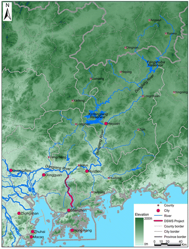
The DjR basin is the major freshwater source for the vital support of agricultural and industrial production and livelihood in the Pearl River Delta (PRD), with a total population of 47.42 million in 2010, which includes a chain of megacities (e.g. Hong Kong, Shenzhen and Guangzhou; Table ). Other major tasks of river management include flood management, power generation, shipping, and reducing salt intrusion and pollutant discharge. The downstream end of the DjR basin is the most developed area and plays a pivotal role in many aspects of Guangdong Province and the Pearl River Delta region.
Table 1. Socio-economic situation in the Dongjiang River basin, 2010.
In recent years, water management in the DjR basin has been facing some significant challenges, such as rapid population growth, urbanization, industrial development, reduction of agricultural land use, ecological degradation, and annual fluctuation of river flow due to natural and human-induced factors, including climate change. As the discrepancies between increasing water demands and shrinking water supply, as well as seasonal and pollution-induced water shortages, are increasingly acute, DjR basin water allocation is becoming the most important issue. In particular, during the three consecutive dry years of 2002–2004, the recorded annual precipitation was about 30% less than normal, while other issues, such as salt tide intrusion and water pollution, also have frequently occurred in the Pearl River Delta. Thus, the contradiction between water supply and demand has become increasingly prominent (Liu, Yang, Lu, Deng, & Immanuel, Citation2012).
Analytical techniques and data
Several approaches were adopted, and multiple results are integrated in this article. An empirical analysis was applied to investigate water features in the DjR basin. Quantitative descriptions were also adopted with available observed data and statistics. Current water use, water allocation and water resources management are discussed that integrate with the characteristics of the basin, relevant statistical data and institutional schemes of the DjR basin. The previous, current and projected climate change trends are discussed as a background for analysis of water allocation in the basin. Previous temperature (1956–2011) and precipitation (1958–2010) data were collected and analyzed for historical changes of climate; quantitative projections of the trends in precipitation and temperature in the Pearl River Delta area were conducted and further analyzed, using the Max Planck Institute for Meteorology Earth System Model at low resolution (Giorgetta et al., Citation2013; for details see the online supplementary data, at https://doi.org/10.1080/07900627.2016.1264294). A critical literature review was applied to compare and integrate results on past and future climate. Moreover, empirical analysis was conducted to support the identification of climate change impacts on the DjR water system, and to generate an overview of the climate-based water characteristics of the DjR basin.
Methods for water allocation analysis
The management of a river basin involves distributed, local decision processes, as well as mechanisms that coordinate individual decisions and manage basin-level issues (Yang, Zhao, & Cai, Citation2010). In order to develop effective water allocation and to facilitate good practice of river management, stakeholders need to adopt good descriptive and integrative approaches. The approach should be dynamic and prospective, so that it can reduce potential impacts across different scenarios (e.g. drought, water pollution). Over the past decade, studies have increasingly emphasized stakeholder analysis in water and environmental resource management decisions (Jepsen & Eskerod, Citation2009; Lafreniere, Deshpande, Bjornlund, & Hunter, Citation2013; Reed et al., Citation2009; Shively & Thompson, Citation2016; Trawick, Citation2003).
This article proposes a stakeholder analysis to outline the main principles underlying basin water allocation. The stakeholder analysis method is based on the levels of interest in and influence on water resources management (Trawick, Citation2003). Stakeholders can be classified into four categories: key players, context setters, subjects and crowd (Figure ). In theory, a stakeholder is defined as a person or organization that has a certain interest or ‘stake’ in a specific issue (Reed et al., Citation2009), for example, the utilization of a resource or the activities of an organization (Jepsen & Eskerod, Citation2009). Stakeholders may also have a certain degree of ‘influence’ over that particular issue or resource, e.g. freshwater resources (Lafreniere et al., Citation2013).
Figure 2. Stakeholder mapping according to level of interest and influence.
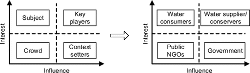
In the case of the DjR basin, the freshwater resources strongly rely on conservation of the river’s originating headwater area (around the Heyuan area) and protection of the ecosystem services and goods the stakeholders rely on. Some current issues are not fully understood, for example the mechanisms of freshwater management system of the DjR, as well as governance and organizational issues between the stakeholders, e.g. the degree to which stakeholder groups and entities are involved in or affected by policy decisions. In this article, ‘influence’ is defined as the capacity to affect the freshwater resource management of the DjR. Stakeholders in the basin are mapped according to a matrix with two axes (level of interest and influence). This approach enables a general classification of stakeholders into four categories (key players, context setters, subjects and crowd), as shown in the left-hand part of Figure . The matching categories for water allocation in the DjR basin area are identified and illustrated accordingly in the right-hand part of the figure.
Data sources
Due to the large range of elements involved in this study, primary data were collected from many sources. Statistical data came from local statistical publications and government documents, for example the 6th Census and statistical yearbooks of the cities and counties (Guangdong Statistics, Citation2012) and open online data from the Hong Kong Census and Statistics Department (Hong Kong CENSTATD, Citation2013). The Guangdong Water Resource Bulletin (GD Water, Citation2013) and the Water Resource Bulletin of the Pearl River Basin (Pearl River WRC, Citation2013) are the main sources for water data. The Web-based database of the Dongjiang River Basin Authority (http://www.djriver.cn/) also provided important information on the basin.
Observational data were mainly obtained from published literature (He & Yang, Citation2011) and government documents, like the yearly Guangdong Statistics (Citation2012). In particular, the temperature data are from Chen, Ma, and Tang (Citation2011), He and Yang (Citation2011) and the statistical databases of the Pearl River Delta cities, e.g. Huizhou Statistics (Citation2011). The analysis of precipitation during 1957–2009 is based on China’s daily terrestrial climate data-set in the China Meteorological Data Sharing Service System (http://www.climate.hl.cn/), with a focus on the DjR basin. The elevation data of ASTER GDEM (V1) are from the International Scientific & Technical Data Mirror Site, the Computer Network Information Centre, and the Chinese Academy of Sciences (http://www.gscloud.cn/).
In addition, information (including academic literature) on current water allocation issues was obtained during field work in the case-study area in November–December 2011. Nineteen interviews were conducted with researchers, government officials and civic organization activists in NGOs in the DjR basin. They were all involved in the four stakeholder categories of water allocation in the DjR basin. Seven different sampling sites in the downstream area of the DjR were visited, which supported direct information on water distribution, water pollution and soil erosion (for details, see the online supplementary data).
Water features in the DjR basin
According to the DjR Basin Authority, the water resources of the basin are evaluated by the sum of precipitation-induced surface runoff and underground water. With this principle, the average amount of water resources of the basin is 33.11 km3 from the annual runoff flow series between 1956 and 2005. Runoff fluctuates widely every from year to year, with a maximum of 37.44 km3 in 1975 and a minimum of 5.05 km3 in 1963. In 2011 the total amount of the DjR basin water resource was 20.9 km3, 16.5% less than the previous year (Table ). Water production per square kilometre (water production modulus) reaches 1.1 million m3.
Table 2. Water resource supply and consumption in the Dongjiang River basin in selected years.
However, distribution of rainfall in the DjR basin is uneven. Annually, 85% of the rainfall is concentrated in the rainy season (April–September), of which heavy rains in May and June represent more than half. Rainfall during this (wet) period is normally intensified and short, because of the sub-tropical monsoon climate, with frequent rainstorms and typhoons from the West Pacific. As a result, floods may occur, but the inland floodwater and stormwater are normally unusable, for lack of proper stormwater storage facilities (e.g. stormwater tanks and artificial ponds) and unequipped urban catchment management systems. In contrast, the dry season (October–March) brings only 15% of the annual precipitation, resulting in drought in some sub-areas, as well as intrusion of salt tides, which often occur in that period.
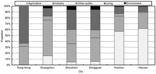
Water supply is the gross amount of water provided to users by a variety of water projects, including surface water, groundwater and other water sources (e.g. sewage treatment, reuse and rainwater harvest). In 2011, the total water supply of the DjR basin reached 4.55 km3 (excluding 0.82 km3 to Hong Kong). Surface water is the main source, accounting for 96.6% of the total water supply (Table ). Water consumption is more or less equal to supply, and is statistically categorized in five sectors: agriculture, industry, urban public, living and environment. In 2011, agriculture consumed 2.05 km3, accounting for 51% of the total water consumption, while industry accounted for 27.9%.
In 2011, Guangzhou had the highest per capita water consumption (574.51 m3), and Hong Kong the lowest (130.88 m3, excluding its seawater use). The downstream cities in the DjR basin, namely Hong Kong, Shenzhen, Guangzhou and Dongguan, all rely on the DjR water resources, which directly transit the freshwater from the upstream (i.e. Heyuan). The structure of water consumption varies greatly in the region (Figure ). The proportions of industrial and domestic water use are dominant in the downstream cities, because of low agricultural water consumption. With the acceleration of urbanization, population growth and improving living standards, a growing trend is expected in domestic water consumption in the near future.
Figure 3. Annual water consumption of Dongjiang River basin cities in 2011, by sector.
Water allocation: the Dongjiang-Shenzhen Water Supply Project
The Guangdong provincial government issued its Water Allocation Plan for the Dongjiang River Basin in Guangdong in 2008, regulating the water limit for cities in this basin and Hong Kong (Table ). According to this allocation scheme, some cities (Shenzhen and Dongguan) exceeded the limit in 2010, and they have to pump more groundwater sources and look for water resources outside the DjR basin.
Table 3. Water allocation scheme for the Dongjiang River basin for cities in Guangdong Province and Hong Kong (all figures in km3).
Due to the distinct wet and dry seasons, there are sharp inter-annual fluctuations in rainfall and runoff in the DjR basin. In the relatively dry year of 2004 only 1217 mm of rainfall was recorded. Accordingly, the water resource of the DjR basin was 13 km3 for the year, which reached only 40% of the average annual runoff. Though the Guangdong provincial government agreed to provide a total of 11 km3 of water to Hong Kong in the Agreement on Dongjiang Water Supply to Hong Kong, severe drought would affect the water supply of the entire region and also stress the supply to Hong Kong (Yang, Zhang, & Ngaruiya, Citation2013).
The Dongjiang-Shenzhen Water Supply Project (DSWS) project starts from the Dongjiang main stream in the Qiaotou town of Dongguan. Freshwater is pumped and pipelined backwards along the Shima River, which is a branch of DjR, to the Shenzhen Reservoir and then to Hong Kong (Figure ). Although the project was initially built mainly to supply good-quality freshwater to Hong Kong, other cities (Shenzhen, Dongguan and Guangzhou) also benefited from it.
The water supply to Hong Kong has been increasingly demanding in the 50 years since 1964 (the Hong Kong government signed the freshwater supply agreement with the Guangdong provincial government during the colonial jurisdiction). Nowadays over 80% of the freshwater resources in Hong Kong are supplied from the DjR, and during recent decades the freshwater supply agreement has been adjusted for the projected increasing water demand, to cope with the ongoing rapid socio-economic development of Hong Kong. Currently, the actual water supply to Hong Kong is 800–900 million m3 per year. The maximum capacity of the project is 1100 million m3 per year (Hong Kong DNPC, Citation2011).
According to the Guangdong-Hong Kong Water Supply Agreement (2012–2014) (Xinhuanet, Citation2011), Hong Kong spent HK$ 3.54 billion to buy 820 million m3 of Dongjiang water in 2012, corresponding to a price of around RMB 3.5 (equivalent to USD 0.5) per cubic metre. The challenge is to meet the actual needs of Hong Kong’s water supply and ensure 99% reliability of the total supply volume package in the coming years. In the next three years the same basic amount (820 million m3) of water will be supplied to Hong Kong from DjR, with an increment of 5.82%, 5.78% and 5.77% annually of the charges. This price is apparently much higher than in Dongguan and Shenzhen for the same project. Since 1 June 2011, the average water charge to Dongguan by the DSWS project has been set at RMB 0.404 per cubic metre, and for Shenzhen at 0.776 RMB per cubic metre (Liu, Citation2011). Considering the recent trends in water consumption and demand, future competition and conflicts over freshwater supply among the megacities in the DjR basin are emerging. Nevertheless, the agreement highlights that the DSWS project will still ensure that Hong Kong has enough freshwater supply, and maintain the targeted 1.1 km3/y, supplying about 80% of the annual freshwater consumption in Hong Kong.
Water management
This study presents socio-economic data for the cities in the DjR basin (Table . There are significant social and economic differences between the upstream and downstream cities. Urbanization and GDP per capita are two key indicators that represent the overall development level in this article. The upper DjR basin cities (Heyuan and Huizhou) have far smaller values in these indicators than the downstream cities (Dongguan and Shenzhen), which implies that the upper cities are poorer and less developed, and have less economic power.
Figure shows the relationship between government stakeholders in this basin at four different administrative levels (nation, province, city and county), enhanced by the centralized governance system of the national ministries in Beijing. In the Pearl River Delta case, it is more complicated, as Hong Kong and Macau are special administrative regions, which are operated by different political jurisdiction systems, based on the ‘one country, two systems’ rule. In addition, Shenzhen was established as a special economic zone in 1984, which means that Shenzhen is not directly governed and managed by the Guangdong provincial government but enjoys a high level of self-governing administrative mechanisms. Accordingly, political and economic power could be categorized as descending from the highest levels in Hong Kong and Shenzhen to Dongguan, Huizhou, Heyuan and Xunwu.
Figure 4. Schematic diagram of the governmental system of the Dongjiang River basin.
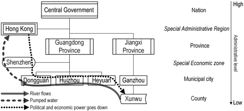
The DjR flows from Xunwu and Heyuan to Huizhou and Dongguan; then the DjR water is pumped to Shenzhen and Hong Kong through the large pipeline mentioned above. Thus, water resources and political-economic power are related in opposite directions in this case: freshwater resources are purchased by Hong Kong or exchanged with other benefits, driven by financial mechanisms. The overall social utilities of the freshwater resource appear to be optimized, yet the local-level redistribution of costs and benefits is often unbalanced (Wang et al., Citation2016). Also, this exchange depends strongly on both sides’ resource quantity and willingness to exchange (Yang, Zhang, & Ngaruiya, Citation2013), which could easily be affected by climate extremes (droughts), pollution, or social-economic changes in the Pearl River Delta region.
Climate change and its impacts in the DjR basin
The precipitation trends during the last century have not been obvious in China, but since 1956, a weak increase has been observed, in particular in south-east China (Ding et al., Citation2006). When downscaling to the DjR basin, both precipitation and surface runoff show more or less stable trends in the last five decades (Figure ). Generally, average annual rainfall in the DjR basin was about 1800 mm, 79% of which occurred in April–September. The geographical distribution of rainfall has gradually shifted from upstream to downstream. The annual average runoff volume at the Boluo hydrological station is 23.65 km3.
Figure 5. Changes of annual temperature and precipitation in Dongjiang River basin, 1958–2010 (from Lü et al., Citation2013).
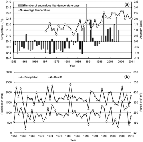
Figure 3 also demonstrates a synchronized trend of rainfall and runoff with inter-annual variability; the correlation coefficient is 0.89, p < 0.01 (Lü et al., Citation2013). This indicates that rainfall is the major source of the DjR runoff. In addition, Lin, Lian, Chen, and Lu (Citation2014) found that the monthly flow decreased during flood periods, but increased greatly during dry periods because of reservoir construction and operations.
Further detailed analysis based on observational data finds significantly increasing precipitation in spring and winter, but decreasing precipitation in summer and autumn, in the DjR basin during 1956–2002 (Chen, Zhang, Lu, Zhang, & Zhang, Citation2011), while the average annual maximum precipitation in the area has been decreasing. A study exploring the forces driving local precipitation in the DjR basin found that eastern-Pacific warming caused more precipitation in autumn and winter, but less precipitation in summer (Zhang, Li, Singh, Xu, & Deng, Citation2013).
This indicates that the precipitation characteristics of the DjR basin are fairly linked to the climate conditions of eastern Asia and the Pacific. Wang, Tan, and Chen (Citation2011) found an increasing trend in the ‘most consecutive no-rain days’ in the DjR basin during 1956–2009, which indicates a rise of extreme drought.
Unlike the stable precipitation pattern, temperature in the DjR basin shows a significant increase over the last five decades, while other climate elements like evaporation, sunshine and humidity decreased during the same period (Lin, He, Lei, & Chen, Citation2011). A temperature increase of 0.39 °C per decade has been observed from 1971 to 2011 in the Pearl River Delta; the city centres of Shenzhen, Guangzhou and Hong Kong warmed even more, due to urbanization effects (He & Yang, Citation2011; He et al., Citation2016). The temperature of the DjR basin made a jump in 1997 and maintained an evident increase thereafter. Thus, the average warming over the past 50 years actually occurred mainly in the last decade (Lin et al., Citation2011).
Runoff changes in the DjR basin are dominated by the combined effects of climatic factors, especially precipitation and temperature. More precipitation may cause greater discharges to runoff, while stronger evaporation reduces runoff. Other physical factors also have impacts on the basin water system (e.g. El Niño, sun activity and vegetation index), but the mechanism is not fully understood (Wang et al., Citation2010). Moreover, Du (Citation2009) analyzed the correlation of precipitation and runoff in different decades during 1956–2005 and found that the runoff is increasingly affected by human activities, for instance hydraulic engineering and reclamation.
Climate change projection
Downscaling the climate model with different climate scenarios shows several trends in temperature and precipitation in the research area (Figure ). All trends in temperature in three representative concentration pathway (RCP) scenarios tend towards increase, but with a difference of more than four degrees till the year 2100. Annual mean precipitation shows an increasing trend in the past, but no clear trend in the future scenarios. There are significant fluctuations in annual mean precipitation under all the scenarios, reaching a variation of around 1500 mm (Figure ).
Figure 6. Model projections of (a) temperature and (b) precipitation in the Pearl River Delta under Representative Concentration Pathway (RCP) scenarios 8.5, 4.5 and 2.6 to the year 2100.
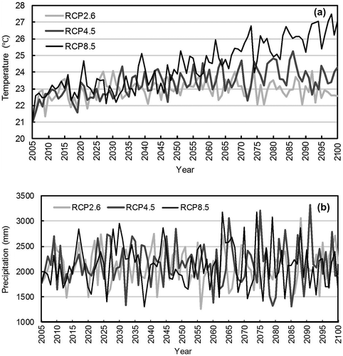
However, existing research in the DjR basin and its surrounding areas (e.g. the Pearl River Delta) come to slightly different conclusions (Table ). For instance, research indicates a decreasing trend in future precipitation for the DjR basin from 2011 to 2099, whether in a high or low greenhouse gas emission scenario (Wang, Rong, Wang, & Wei, Citation2011). Summarizing these results leads to a strong conclusion that the temperatures in the Pearl River Delta will continue to rise, and precipitation will show more extremes, which means more frequent floods and droughts.
Table 4. Literature overview of recent and likely future trends of climate change in the Pearl River Delta, China.
Industrialization and urbanization are continuing in the DjR basin and generate growing emissions of CO2 and other greenhouse gases, which represent a large latent source of future warming and additional changes that will have a major impact on the region (He & Yang, Citation2011), e.g. a significant increase of warm days and nights. The assessment report on climate change in Guangdong (Yu et al., Citation2007) indicates a temperature increase of 2.8 °C by 2100; the greatest warming is likely to be in urbanized areas. Integrating these results, the temperature in the DjR basin is likely to keep rising in the twenty-first century.
In the future, the specific rates of precipitation change may vary, but the trends are mostly increasing. However, the general trend does not necessarily mean a wetter situation, due to more frequent occurrences of extreme weather. According to projections from the Hong Kong Observatory, extreme drought periods in the twenty-first century will be about twice as frequent as in the last century in Hong Kong (Ginn, Lee, & Chan, Citation2010). Therefore, overall precipitation of the DjR will probably increase slightly in this century, but temporary and extreme precipitation will be highly variable in the area.
Climate change impacts on the water system
Climate change affects water quantity, quality and spatial-temporal distribution, with potential negative impacts on the water system in three categories: water shortage, flooding and pollution. Of these factors, climate-related water pollution has rarely been discussed in the literature, although climate change interferes with water quality in various ways. For instance, higher temperatures could boost algal blooms in rivers and reservoirs; droughts could intensify freshwater pollution; extreme flooding could cause sewer/sewage overflows; heavy downpours can flush more soil sediments and contaminants into water bodies; and sea level rise increases the risk of saltwater intrusion (Wilby & Perry, Citation2006). Since this article focuses on situations of less water availability, flooding and its associated impacts are not explored.
Water shortage
In many areas, climate change is likely to increase the demand for water while diminishing its supply. This shifting balance is challenging water managers to simultaneously meet the needs of growing communities, sensitive ecosystems, farmers, landowners, energy producers, and manufacturers. For urban areas with pronounced seasonal precipitation variability and dependence on imported water resources, the expected costs associated with climate change scenarios are higher than those of the historical hydrologic conditions (O’Hara & Georgakakos, Citation2008). The DjR freshwater resource is a top-priority issue for governing the whole basin, to achieve sufficiently good quality of water supply and address water shortage concerns.
In the context of global climate change, the regional hydrological system would be affected in direct and indirect ways. Studies illustrate that precipitation changes or fluctuations are major factors that dominate the amount of available freshwater resources (Wang et al., Citation2010). Inter-annual variability of rainfall and runoff trends show certain synchronization: rainfall trends and variation greatly affect the inter-annual variability and trends of the DjR basin runoff.
Rising temperature is a driver of more intense hydrological circulation, leading to more evaporation, less runoff and more severe droughts. A study by the US National Academies (Citation2011) projects that streamflow will be reduced by 5–10% per 1 °C warming.
Due to the changes in precipitation and temperature, soil water content and surface runoff are also likely to decline, which therefore have an indirect impact on gross water availability. Although soil moisture change is a dynamic factor in the basin’s terrestrial hydrological processes, precipitation and evapotranspiration are more important components in regulating the water balance over the DjR basin (Chen & Wu, Citation2006). Climate change potentially also influences water resources through greater hydrological variation, which means increasing frequencies of drought and flood.
Statistics also show that the month with maximum rainfall and the month with greatest runoff are mostly coincident (coincidence rate of 73%), while the months with minimum rainfall and runoff are much more staggered (coincidence rate of 25%; Lü et al., Citation2013). This further suggests that increasing artificial hydraulic facilities like dams and reservoirs play a greater role in regulation in the dry season and have a more prominent impact on runoff. However, numerical modelling results suggest that human regulation activities cannot impact the scaling properties of the streamflow series but only influence the magnitude of fluctuations. Therefore, it is concluded that the streamflow variations were mainly the results of climate change and precipitation variations (Zhang, Xu, Yu, Liu, & Chen, Citation2009). In this case, the future surface runoff of the DjR basin will probably decrease in a scenario of less precipitation and higher temperature.
Climate change will bring more frequent extremely dry weather, and the chance of continuing drought will increase. It is projected that these factors could affect the cities by reducing their local rainwater collection. In the dry years of 2004 and 2009, according to information provided by the Water Resources Bulletin of Guangdong Province (GD Water, Citation2013), the average annual rainfall of the DjR was 30% and 22% less than normal, respectively, and the total storage of the three biggest reservoirs (Fengshuba, Xinfengjiang and Baipenzhu) in the DjR basin was 25% less than normal. Many hydropower generation systems had to be shut down to ensure water supply to cities. Results have shown that there is a higher risk of hydrological droughts in the upper DjR basin (Zhang, Xiao, Singh, & Chen, Citation2013), and the risk of water shortage tends to be gradually increasing when severe drought occurs. Given the fast development and growing water demand of the upper cities, competition for DjR water is expected to increase (Yang, Zhang, & Ngaruiya, Citation2013). Should there be a significant drought in the basin (as there was in 1963), water consumers would face a limited water supply. In the future, the effects would be severe and might cause tension between the upstream and downstream areas.
Water pollution
Climate change goes beyond more or less available water and may include changes in the water quality of rivers and lakes (Vörösmarty et al., Citation2000). This has implications for maintaining water supply and river ecosystems.
First, water quality can be affected by changes in the flow regime, which may influence the concentration of contaminants. Decreasing base or minimum flows imply less volume for dilution and hence higher concentrations of contaminants downstream. Discharge of many human-induced toxic substances (e.g. heavy metals and organic pollutants) into the freshwater environment has been banned or restricted. However, many of them persist in soils and sediments, and either remain in contact with food chains or can be remobilized and taken up by aquatic biota (Whitehead, Wilby, Battarbee, Kernan, & Wade, Citation2009). The major concern with respect to climate change is the extent to which toxic substances will be remobilized and cause additional contamination as water temperatures rise. These soil-persistent contaminants are likely to be concentrated in river sediment during the dry season and thus worsen river pollution.
Second, water quality could suffer in areas experiencing increasing rainfall as well. Increased storm events, especially in summer, could cause more frequent combined sewer overflows, discharging highly polluted waters into water bodies. For example, increases in heavy-precipitation events could cause problems for the water infrastructure, as sewer systems and water treatment plants are overwhelmed by the increased volumes of water (USGCRP, Citation2009). Heavy downpours can increase the amount of runoff into rivers and lakes, washing sediments, nutrients, pollutants, trash, animal waste and other materials into water supplies, making them unusable, unsafe, or in need of water treatment (Shi et al., Citation2007). This leads to reduced land-surface persistence for contaminants and increases their mobilization along the river. Given these considerations, it is reasonable to conclude that contaminants may become more mobile with climate change (Paul et al., Citation2012).
Third, the most immediate reaction to climate change is expected to be rising river and lake water temperatures, along with warming air (Shen, Citation2012). Together with land-use change, climate change will exacerbate the water quality problem of eutrophication (Whitehead et al., Citation2013). Enhanced growth of algal blooms in rivers and reservoirs could affect levels of dissolved oxygen and the costs of treating water for potable supply. In the DjR basin, phosphorus comes from point sources such as wastewater treatment plants and from diffuse sources such as agriculture. Cities in the upper DjR basin reaches, such as Huizhou and Heyuan, have accepted the setting up of many of the transferred industries from the Pearl River Delta. This combination of industrial contamination, agricultural pollution and dispersive rural sewage is making the water quality of the river worse and threatens the water supplies (Liu et al., Citation2012). In fact, Shenzhen and Dongguan demand more water from the DSWS project but continue to discharge sewage to the DjR, which makes the situation much more complicated.
In addition, as the regional sea level is expected to continue rising and more freshwater is removed from rivers for human use, saltwater will have the chance to move farther upstream. Drought can cause coastal water resources to become more saline as freshwater supplies from rivers are reduced, which would further exacerbate the severity of water shortage.
Stakeholder analysis of water allocation
Although generally water resources in the DjR basin are fairly rich, water pollution and the uneven distribution of precipitation in the basin contribute to seasonal and quality-induced water shortage. Against the background of climate change and urbanization, water shortage in the DjR basin is getting more and more serious. In the short term, the most important aspect of water concerns is water allocation, with the significant and uncertain impacts of climate change. This section presents the results of a stakeholder analysis of the water allocation issue in the DjR basin.
Analysis of stakeholder interactions
The overall framework is based on the bottom-up coordination of stakeholders in order to improve their modest benefits, which means that all relevant parties pursue their own interests at the same time but do not affect others in pursuing their interests. Under this general principle, the presence of water needs of all stakeholders indicates obligations to maintain both water quality and quantity.
The analysis is based on a scenario where in the context of water shortages all stakeholders limit their water consumption, control their sewage and maintain the water quality, especially for downstream areas. Due to the special nature of water resources with strong externalities, these limitations, controls and maintenance tasks often require compensation. These are the questions this article discusses in the following.
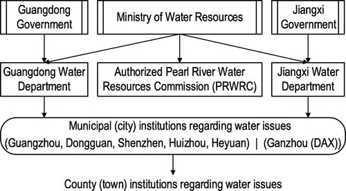
The water governance structure of China is framed by the pattern of decentralization (Cosier & Shen, Citation2009), which means that the central government decentralizes water resources by giving power and authorization to provincial and municipal governments. The Chinese Ministry of Water Resources, at the top water governance level, establishes national legislated regulations and guidance to oversee all issues of water. However, China has several large rivers (e.g. the Yangtze, Yellow, Pearl, and Huai) and lakes (e.g. the Taihu Basin) which involve many provinces and municipalities (Harvey et al., Citation2009). The ministry has set up seven specific river water resources commissions to deal with regional river and water issues, e.g. the Pearl River Water Resources Commission (PRWRC) in the case of the Pearl River – including Dongjiang.
The PRWRC has the highest authority for managing the water resources, in particular to deal with issues across boundaries. The water governance power is further decentralized to the Guangdong provincial government’s water institution, the Department of Water Resources of Guangdong (GD Water), and further down at the municipal levels, cascading to the lowest level of the water governance structure at the county/town level (Figure ).
Figure 7. Water governing system in the Dongjiang River basin.
The decentralized water governance structure and its stakeholders regarding DjR water resources were further identified through grey literature and secondary data (Table ). Four categories of stakeholders are considered.
Table 5. Stakeholder mapping: functions and differences of selected key stakeholders in the Dongjiang River basin.
Context setters are characterized by low interest and high influence: PRWRC, GD Water (including the Dongjiang River Commission Board), and the Guangdong Raw Water Supply Company (responsible for the DSWS project). The context setters are thus mainly the stakeholders with the strongest influence in water resources governance – regulating and managing the DjR.
Key players have high interest and high influence. Examples are the municipal and county governments along the DjR (municipal water bureaus, municipal planning bureaus and municipal environmental protection bureaus), and the Development and Reform Commission at different government levels. Key players typically have strong interest in using the river water for their socio-economic development and environment, and strong influence over sewage pollution and water conservation issues. In addition, the key players are the immediate practitioners who both operate and manage the water resources, including freshwater pollution control and water conservation.
Subjects are assumed to have high interest but relatively low influence; these include other municipal governments, such as local communities, industries and NGOs (e.g. WWF) that are related to water resources. Likewise, many stakeholders with an interest in DjR water resources management and the relevant information are categorized as subjects.
The crowd refers to stakeholders with low interest and low influence, such as academics, consultants and other NGOs.
Influential and affected stakeholders
In the study, 37 stakeholders were identified who play a role in DjR water management, based on interviews with local experts representing various sectors. The number of stakeholders in each category is different, and their roles are varied.
The influence of the stakeholders on and the extent of being affected by the basin water management were estimated, and approximate scores (1–10) were assigned based on the subjective descriptions of the interviewed experts. Decimal values were used to avoid exact overlaps of different stakeholder categories. The size of the stakeholder category was assigned in the range of 1–100 to avoid extreme values; e.g. the number of riverside household stakeholders is very large, but the number 100 was assigned to represent it.
With this information, a plot was drawn of the perceived influence of stakeholders on DjR water management versus how much they are likely to be affected by water management regulations. The results show that most stakeholders lie on the diagonal; i.e. many stakeholders are as influential as they are affected (Figure ).
Figure 8. Key stakeholders influencing and being affected by Dongjiang River basin water management. Stakeholders are grouped into seven categories, represented by different colours. The size of the circle indicates the relative number of stakeholders in that category. (For more details, see the online supplementary data at https://doi.org/10.1080/07900627.2016.1264294.)
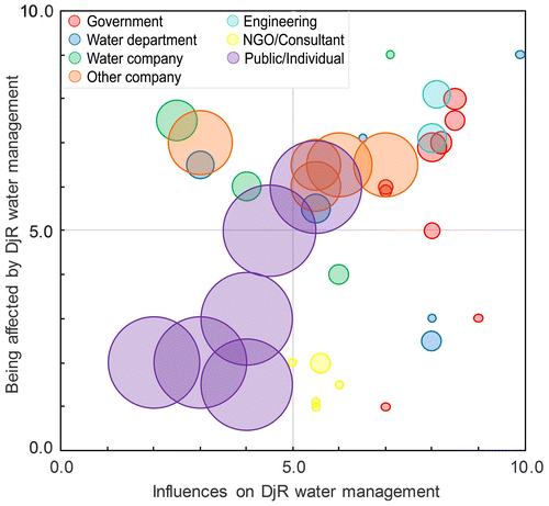
For the sake of simplicity, actors that are both highly influential and strongly affected are termed ‘most important’. Local governments and especially their water departments are the most influential stakeholders in DjR water management; at the same time they are the most affected ones, as they can benefit or suffer from water management regulation. There are some exceptions: the Ministry of Water Resources and GD Water (small circles at the bottom right of the figure) have high decision-making power to influence DjR basin management, but are rather weakly affected, since the DjR basin accounts for only a small part of their managing field.
As a department of the Pearl River Water Resources Commission, the Dongjiang River Commission Board (small circle at top-right edge) is obviously the most influential and affected stakeholder, as it is the agency directly responsible for all issues in the DjR basin. Among the other water departments, those in the upstream areas have more influence on the basin water system but are less affected by the water quantity and quality, while in the downstream areas the situation is reversed. Hard-engineering projects such as the construction of dams, reservoirs and hydropower stations are also strongly influential and affected, on the physical side of the basin water system.
Water supply companies from the upstream to downstream areas are distributed evenly, with decreasing influence and increasing suffering from the poor water quality. These stakeholders generally have limited power to influence decision making, but they can urge the adoption of preferred measures and strategies. Moreover, when they are affected by the basin water system they can only appeal for subsidies or increase water prices. Other companies and enterprises in mining, construction, aquaculture, tourism, etc., are at the middle level regarding their influence on and being affected by DjR water management. Many of these stakeholders are distributed widely in the basin, which indicates their significance. Their operations generally involve large amounts of water input, wastewater emission and water pollution, and they are often the first category of stakeholders being regulated and rectified when the basin water system is under stress.
There are some NGOs, academics and consultants concerning DjR water issues from the perspective of public welfare, such as WWF, Greenpeace, local universities (academics) and research institutes (small circles, bottom centre). They are hardly affected by DjR water management but they do have some influence on basin issues by discussing problems, raising awareness and proposing solutions. A large number of local communities and individuals in the basin, including farmers, fishers and urban citizens, generally are less influential in the DjR basin water system, although some big communities or groups in the upstream area may have considerable power to intervene in the management of the river basin.
Figure further indicates that most stakeholders in administration and politics are important in basin water management, together with some practical actors who manage the physical water system with engineering measures. Individual citizens, as the main representatives of the public, seem to be less powerful. Regarding influence on the basin, the public can hardly express their interests and are somewhat less and indirectly affected. Finally, non-profit organizations that represent public welfare could be further encouraged to raise the voice of the public, since their current activities are inadequate.
Balance of conflict and cooperation under climate change
The above sections discussed how water risks under climate change and stakeholder interests in the DjR basin could be investigated in the foreseeable future. Along with the population growth and economic development in the basin, conflicts between water demands and water shortages, and between water pollution and water conservation, will arise more frequently and sharply as a consequence of climate change. Some stakeholders already suffer from water quotas and pollution controls; in the case of a significant drought in the basin (as occurred in 1963), the effects would be severe and might cause tensions among water users. Even a moderate drought could have a ripple effect in the system, whereby less flowing water would be more vulnerable to pollutants, resulting in higher pollutant density. Lower reserve volumes would also make water pumping more expensive due to higher electricity consumption, which in turn would increase consumer water prices. Thus, the risk of conflicts could be everywhere if the DjR water system cannot support the basic water demands of its stakeholders.
Cities in the upper reaches of the DjR basin, Huizhou and Heyuan, have accepted setting up many of the transferred industries from the downstream areas. This combination of industrial contamination, agricultural pollution and dispersive rural sewage is causing the water quality of the DjR to worsen, threatening the freshwater supply to downstream cities (Yang, Zhang, & Ngaruiya, Citation2013). To control water pollution at the source, the upstream cities are restricted in their land development, sewage emission and use of pesticides, which therefore restricts their development of industry and agriculture. Even though the upstream cities ask for economic compensation for this restricted development, and though the downstream cities might be willing to compensate them, specific agreement is hard to reach, and no comprehensive compensation mechanism exists, partly due to the complexity of this issue. Another pollution risk is from ground-surface pollutants that may be transported from stormwater and discharge into the reservoirs during extreme-rainfall events. In such complicated situations, conflicts among stakeholders regarding water pollution and protection have already arisen.
Thus, climate change affects the causal network that links transboundary water availability and water use to human well-being in several ways (Link, Piontek, Scheffran, & Schilling, Citation2012). This network also shapes actions on water development with transboundary consequences and therefore the relations between the riparian cities and counties. While a direct link between changing climatic conditions and conflict is difficult to verify, the indirect effects are possibly more significant. Incentives to mitigate conflicts and promote cooperation are very important at this point. These could include strong outside encouragement or even pressure, as well as conditional external financial support. One particular incentive for the DjR basin to create a cooperation scheme could be its increasing dependence on information on rainfall and flows in order to efficiently prepare for floods and manage water allocation.
On the other hand, all stakeholders in the basin could take the challenge as an opportunity to cooperate in saving water, enhancing water efficiency, controlling pollution, and treating and recycling water. Moreover, stakeholders could cooperate to jointly implement viable solutions that they all can benefit from, for instance to store floodwater and stormwater, to transfer outside water, and to desalinate seawater. However, motivations are encouraged to improve the current situation, and great leadership is needed that combines with sound research and political determination.
Strategy for water allocation
To balance the various interests of the stakeholders, a basin-wide water cooperation framework is introduced (Figure ). The main aim of this foundation is to obtain financial support from freshwater consumption in the DjR basin, then invest these premiums in controlling water pollution and compensating water conservation.
Figure 9. Framework for balancing water consumption and conservation among ‘key player’ stakeholders.
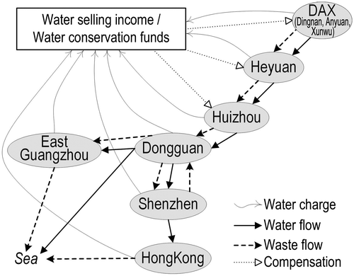
For instance, the upstream areas Dingnan, Anyuan and Xunwu (DAX) and Heyuan get compensation for conserving water resources to offer good freshwater to the cities in the lower DjR Basin (Hong Kong and Shenzhen). The upstream cities/areas (Heyuan) not only spend a huge amount on afforestation, river management and ecological migration, but also give up some project investments in order to stop the approval of mining rights, to control water pollution. In poverty-stricken counties, the upstream areas contribute to the long-term water utilization of the downstream areas, which are the most economically developed areas in the country.
This basin foundation would collect water fees from all water consumers but compensate mainly upstream areas that protect good water quality. At the same time, the foundation could also charge fees for sewage emissions or punish water pollution activities. The operation of the foundation could follow a semi-market rule, with compensation for water allocation plans in extreme situations.
In addition, cities like Hong Kong may reduce their water dependence on the DSWS project after the next water supply agreement, due in 2017. At least, they could try to reduce the consumption proportion of DjR water by increasing self-managed water conservation. The government of the Hong Kong Special Administrative Region is planning to extract freshwater resources by seawater desalination and by increasing the capacity of the catchment, which could be helpful to consolidate more sufficient and independent levels of water supply. However, many citizens of Hong Kong are used to the low-priced public water supply. Civic education on water conservation is weak in Hong Kong (Woo, Wong, Horowitz, & Chan, Citation2012). The DjR riparian cities, which include Hong Kong, could improve the education of the public (for both domestic and industrial sectors) on water conservation, which could be effective in sustainably reducing freshwater consumption, for example by promoting water reuse. While freshwater resources may create severe conflicts, building sufficient and self-independent water supply systems would move the river basin towards more sustainable practices and potentially mitigate conflicts.
Conclusion
This article proposes a systematic analysis of water resources management, climate change impacts and stakeholder networks to explore the complex water allocation mechanisms in the DjR basin in southern China. It provides insights into the plausible changes in the basin water system due to climate change, which indicates significant implications for initiating response strategies dealing with water shortage and water allocation issues in the DjR basin.
As analyzed, precipitation in the DjR will increase slightly but fluctuate greatly in this century, probably increasing water shortage in terms of seasonal drought and poor freshwater quality due to natural and human-induced factors. Upgrading and expansion of engineering measures are approaching the upper limits of the water development potential, which requires alternative options, e.g. optimization of water allocation and demand management.
The research results suggest that participatory water allocation mechanisms are necessary to manage water conflicts, balance development priorities and conserve basin ecosystems. Especially, analysis of stakeholder interactions suggests that the current mechanisms are inadequate to buffer water conflicts and balance regional development. To increase resilience against climate change and sustainability in long-term development, water management should integrate market-oriented mechanisms into the current fixed water allocation approaches. The stakeholder analysis (using the DjR case) further suggests considerable potential in setting up a basin foundation which considers water values, pollution control and conservation compensation to balance the various stakeholder interests.
In the long run, local governments must work actively to increase and divert water sources, to reduce dependence on DjR water. Desalination, water reuse and reservoir construction are the promising directions for increasing freshwater resources in this area.
Funding
This study was supported by the China Scholarship Council and the Cluster of Excellence ‘CliSAP’ (EXC177), University of Hamburg, funded through the German Science Foundation (DFG).
Supplemental data
The supplementary material for this paper is available online at https://doi.org/10.1080/07900627.2016.1264294
Supplemental file.docx
Download MS Word (41.5 KB)Disclosure statement
No potential conflict of interest was reported by the authors.
Related Research Data
References
- Berger, T., Birner, R., McCarthy, N., Diaz, J., & Wittmer, H. (2007). Capturing the complexity of water uses and water users within a multi-agent framework. Water Resources Management, 21, 129–148. doi:10.1007/s11269-006-9045-z
- Chen, X., Chen, Y., & Lai, G. (2002). Optimal allocation of water resources in Dongjiang River Basin. Journal of Natural Resources, 17, 366–372.
- Chen, Z., Ma, H., & Tang, P. (2011). Characteristics and causes of the summer high temperature in Pearl River Delta (in Chinese). Journal of Meteorological Research and Application, 32, 22–25.
- Chen, J., & Wu, Y. (2006). Exploring hydrological process features of the East River (Dongjiang) basin in South China using VIC and SWAT. In Y. D. Chen, & X. Chen (Eds.) Hydrological sciences for managing water resources in the Asian developing world (Vol. 319, pp. 116–123). Guangzhou, China: IAHS Publication.
- Chen, Y. D., Zhang, Q., Lu, X., Zhang, S., & Zhang, Z. (2011). Precipitation variability (1956–2002) in the Dongjiang River (Zhujiang River basin, China) and associated large-scale circulation. Quaternary International, 244, 130–137. doi:10.1016/j.quaint.2010.08.013
- Chu, Y., Hipel, K. W., Fang, L., & Wang, H. (2015). Systems methodology for resolving water conflicts: The Zhanghe River water allocation dispute in China. International Journal of Water Resources Development, 31, 106–119. doi:10.1080/07900627.2014.933096
- Cosier, M., & Shen, D. (2009). Urban water management in China. International Journal of Water Resources Development, 25, 249–268. doi:10.1080/07900620902868679
- Ding, Y., Ren, G., Shi, G., Gong, P., Zheng, X., Zhai, P., ... Dai, X. (2006). National assessment report (1): History and futural trend of climate change in China (In Chinese). Progress in Climate Change Research, 2, 3–8.
- Du, J. (2009). Analysis on the water resources variability and drought risk in the Dongjiang River Basin (In Chinese). ( Master of Science), Sun Yet-sen University, Guangzhou.
- Du, Y., & Li, W. (2008). Projection of future extreme climate change events in South China. Workshop on Climate Change and Climate Prediction in the Pearl River Delta Region, Hong Kong.
- GD Water. (2013). Guangdong Water Resource Bulletin (2002-2011).
- Ginn, W. L., Lee, T. C., & Chan, K. Y. (2010). Past and future changes in the climate of Hong Kong. Acta Meteorologica Sinica, 24, 163–175.
- Giorgetta, M. A., Jungclaus, J., Reick, C. H., Legutke, S., Bader, J., Böttinger, M., ... Stevens, B. (2013). Climate and carbon cycle changes from 1850 to 2100 in MPI-ESM simulations for the coupled model intercomparison project phase 5. Journal of Advances in Modeling Earth Systems, 5, 572–597. doi:10.1002/jame.20038
- Gleick, P. H. (2014). Water, drought, climate change, and conflict in Syria. Weather, Climate, and Society, 6, 331–340. doi:10.1175/WCAS-D-13-00059.1
- Guangdong Statistics. (2012). Summary data of the 6th census of Guangdong province (2010). Retrieved from http://www.stats.gov.cn/tjsj/tjgb/rkpcgb/dfrkpcgb/201202/t20120228_30384.html
- Harvey, G. L., Thorne, C. R., Cheng, X., Evans, E. P., Han, S., Simm, J. D., & Wang, Y. (2009). Qualitative analysis of future flood risk in the Taihu Basin. Journal of Flood Risk Management, 2, 85–100.10.1111/jfrm.2009.2.issue-2
- He, Y., Lin, K., Tang, G., Chen, X., Guo, S., & Gui, F. (2016). Quantifying the changing properties of climate extremes in Guangdong province using individual and integrated climate indices. International Journal of Climatology. doi:10.1002/joc.4739
- He, C., & Yang, L. (2011). Urban development and climate change in China’s Pearl River Delta. Land Lines, July, 2–7.
- Hirabayashi, Y., Mahendran, R., Koirala, S., Konoshima, L., Yamazaki, D., Watanabe, S., ... Kanae, S. (2013). Global flood risk under climate change. Nature Climate Change, 3, 816–821. doi:10.1038/nclimate1911
- Hong Kong CENSTATD. (2013). Hong Kong statistics. Retrieved from http://www.censtatd.gov.hk/hkstat/
- Hong Kong DNPC. (2011). Summery report of the investigation on pollution prevention of Dongjiang water source. Retrieved from http://www.npc.gov.cn/npc/gadbzl/xgdbzl_11/2011-04/08/content_1650698_16.htm
- Hong Kong Observatory. (2012). Observed climate change in Hong Kong. Retrieved from http://www.weather.gov.hk/climate_change/climate_change_hk_e.htm.
- Huizhou Statistics. (2011). Huizhou Statistical Yearbook (2000–2011).
- Jepsen, A. L., & Eskerod, P. (2009). Stakeholder analysis in projects: Challenges in using current guidelines in the real world. International Journal of Project Management, 27, 335–343. doi:10.1016/j.ijproman.2008.04.002
- Lafreniere, K. C., Deshpande, S., Bjornlund, H., & Hunter, M. G. (2013). Extending stakeholder theory to promote resource management initiatives to key stakeholders: A case study of water transfers in Alberta. Canada. Journal of Environmental Management, 129, 81–91. doi: 101016/j.jenvman.2013.06.046
- Li, Y. (2009). Water supply and demand in the Pearl River Delta under a changing global climate (In Chinese) ( Master of Sciences), Capital Normal University of China, Beijing.
- Li, X., Liu, J., & Tang, S. (2012). Review of the researches of climate change in southern China (In Chinese). The 26th workshop on meteorologic science and technology in Guangdong, Hong Kong and Macau, Macau.
- Lin, K., He, Y., Lei, X., & Chen, X. (2011). Climate change and its impact on runoff during 1956-2009 in Dongjiang basin (In Chinese). Ecology and Environmental Sciences, 20, 1783–1787.
- Lin, K., Lian, Y., Chen, X., & Lu, F. (2014). Changes in runoff and eco-flow in the Dongjiang river of the Pearl River Basin. Frontiers of Earth Science, 8, 547–557. doi:10.1007/s11707-014-0434-y
- Link, P. M., Piontek, F., Scheffran, J., & Schilling, J. (2012). On foes and flows: Vulnerabilities, adaptive capacities and transboundary relations in the Nile River Basin in times of climate change. L’Europe en Formation, 365, 99–138.10.3917/eufor.365.0099
- Liu, Y. (2011). Economy of the Dongjiang river. Oriental Outlook, 48. ( In Chinese). Retrieved from http://www.lwdf.cn/wwwroot/dfzk/Focuseast/253501.shtml
- Liu, D., Guo, S., Chen, X., Shao, Q., Ran, Q., Song, X., & Wang, Z. (2012). A macro-evolutionary multi-objective immune algorithm with application to optimal allocation of water resources in Dongjiang River basins, South China. Stochastic Environmental Research and Risk Assessment, 26, 491–507. doi:10.1007/s00477-011-0505-5
- Liu, S., Yang, Y., Lu, H. Y., Deng, T. C., & Immanuel. (2012). Dongjiang Overloaded – 2011 Dongjiang Expedition Report. HongKong.
- Lü, L., Peng, Q., Liao, J., Jiang, Y., & Kang, M. (2013). Fluctuation and trends in precipitation and runoff in the Dongjiang River Basin over 50 years (In Chinese). Resources Science, 35, 514–560.
- National Academies (2011). Warming world, impacts by degree. Retrieved from Climate Stabilization Targets: Emissions, Concentrations, and Impacts over Decades to Millennia.
- O’Hara, J. K., & Georgakakos, K. R. (2008). Quantifying the urban water supply impacts of climate change. Water Resources Management, 22, 1477–1497. doi:10.1007/s11269-008-9238-8
- Paul, A. G., Hammen, V. C., Hickler, T., Karlson, U. G., Jones, K. C., & Sweetman, A. J. (2012). Potential implications of future climate and land-cover changes for the fate and distribution of persistent organic pollutants in Europe. Global Ecology and Biogeography, 21, 64–74. doi:10.1111/j.1466-8238.2010.00547.x
- Pearl River WRC. (2013). Water resource bulletin of the Pearl River Basin (2000–2011).
- Reed, M. S., Graves, A., Dandy, N., Posthumus, H., Hubacek, K., Morris, J., ... Stringer, L. C. (2009). Who’s in and why? A typology of stakeholder analysis methods for natural resource management. Journal of Environmental Management, 90, 1933–1949. doi:10.1016/j.jenvman.2009.01.001
- Schewe, J., Heinke, J., Gerten, D., Haddeland, I., Arnell, N. W., Clark, D. B., ... Kabat, P. (2014). Multimodel assessment of water scarcity under climate change. Proceedings of the National Academy of Sciences, 111, 3245–3250.10.1073/pnas.1222460110
- Shen, D. (2012). Water quality management in China. International Journal of Water Resources Development, 28, 281–297. doi:10.1080/07900627.2012.669079
- Shen, D., & Wu, J. (2016). State of the art review: Water pricing reform in China. International Journal of Water Resources Development, 1–36. doi:10.1080/07900627.2016.1171743
- Shi, P. J., Yuan, Y., Zheng, J., Wang, J. A., Ge, Y., & Qiu, G. Y. (2007). The effect of land use/cover change on surface runoff in Shenzhen region. CATENA, 69, 31–35. doi:10.1016/j.catena.2006.04.015
- Shively, D., & Thompson, A. (2016). Stakeholder collaboration in the Columbia river treaty review process. International Journal of Water Resources Development, 32, 57–76. doi:10.1080/07900627.2015.1018411
- Tingey-Holyoak, J., Burritt, R. L., & Pisaniello, J. D. (2013). Living with surface water shortage and surplus: The case of sustainable agricultural water storage. Australasian Journal of Environmental Management, 20, 208–224. doi:10.1080/14486563.2013.819302
- Trawick, P. (2003). Against the privatization of water: An indigenous model for improving existing laws and successfully governing the commons. World Development, 31, 977–996. doi:10.1016/S0305-750X(03)00049-4
- USGCRP. (2009). Global climate change impacts in the United States. New York, NY: C. U. Press.
- Vörösmarty, C. J., Green, P., Salisbury, J., & Lammers, R. B. (2000). Global water resources: Vulnerability from climate change and population growth. Science, 289, 284–288. doi:10.1126/science.289.5477.284
- Wang, Z., Chen, X., & Yang, T. (2010). Runoff variation and its impacting factors in the Dongjiang River Basin during 1956-2005 (In Chinese). Journal of Natural Resources, 25, 1365–1374.
- Wang, R. Y., Ng, C. N., Lenzer Jr., J. H., Dang, H. P., Liu, T., & Yao, S. (2016). Unpacking water conflicts: A reinterpretation of coordination problems in China’s water-governance system. International Journal of Water Resources Development. https://doi.org/10.1080/07900627.2016.1197824
- Wang, P., Rong, Y., Wang, W., & Wei, L. (2011). Downscaling extreme precipitation in Dongjiang River Basin of China based on SDSM (In Chinese). Highlights of Sciencepaper Online, 4, 1312–1320.
- Wang, Z., Tan, J., & Chen, X. (2011). Variations in longest consectutive dry days in dry season in the Dongjiang River Basin (In Chinese). Geographical Research, 30, 9, 1693–1701.
- Whitehead, P. G., Crossman, J., Balana, B. B., Futter, M. N., Comber, S., Jin, L., ... Read, D. S. (2013). A cost-effectiveness analysis of water security and water quality: Impacts of climate and land-use change on the River Thames system. Philosophical Transactions of the Royal Society A: Mathematical, Physical and Engineering Sciences, 371, 413–428.
- Whitehead, P. G., Wilby, R. L., Battarbee, R. W., Kernan, M., & Wade, A. J. (2009). A review of the potential impacts of climate change on surface water quality. Hydrological Sciences Journal, 54, 101–123.10.1623/hysj.54.1.101
- Wilby, R. L., & Perry, G. L. W. (2006). Climate change, biodiversity and the urban environment: A critical review based on London, UK. Progress in Physical Geography, 30, 73–98. doi:10.1191/0309133306pp470ra
- Woo, C.-K., Wong, W.-K., Horowitz, I., & Chan, H.-L. (2012). Managing a scarce resource in a growing Asian economy: Water usage in Hong Kong. Journal of Asian Economics, 23, 374–382.doi: https://doi.org/10.1016/j.asieco.2012.03.007
- Wu, P., Christidis, N., & Stott, P. (2013). Anthropogenic impact on Earth’s hydrological cycle. Nature Climate Change, 3, 807–810. doi:10.1038/nclimate1932
- Xinhuanet. (2011, October 20). Hong Kong and Guangdong reached agreement on water supply in the next three years. Retrieved from http://news.xinhuanet.com/gangao/2011-10/20/c_122181754.htm ( in Chinese)
- Yang, L., Scheffran, J., Qin, H., & You, Q. (2015). Climate-related flood risks and urban responses in the Pearl River Delta, China. Regional Environmental Change, 15, 379–391.
- Yang, L., Zhang, C., & Ngaruiya, G. W. (2013). Water supply risks and urban responses under a changing climate: A case study of Hong Kong. Pacific Geographies, 39, 9–15.
- Yang, Y. E., Zhao, J., & Cai, X. (2010). A multi-agent system based model for water allocation management in the Yellow River Basin. World Environmental and Water Resources Congress.10.1061/9780784411148
- Yu, Y., Liang, J., Liu, J., Xiao, Y., Qian, G., Lv, Y., et al. (2007). Assessment report on climate change of Guangdong (Selection) (In Chinese). Guangdong Meteorology, 29(3), 1–7.
- Zhang, Q., Li, J., Singh, V. P., Xu, C.-Y., & Deng, J. (2013). Influence of ENSO on precipitation in the East River basin, south China. Journal of Geophysical Research: Atmospheres, 118, 2207–2219. doi:10.1002/jgrd.50279
- Zhang, Q., Xiao, M., Singh, V., & Chen, X. (2013). Copula-based risk evaluation of droughts across the Pearl River basin, China. Theoretical and Applied Climatology, 111, 119–131. doi:10.1007/s00704-012-0656-4
- Zhang, Q., Xiao, M., Singh, V., & Chen, X. (2013). Copula-based risk evaluation of hydrological droughts in the East River basin, China. Stochastic Environmental Research and Risk Assessment, 27, 1397–1406. doi:10.1007/s00477-012-0675-9
- Zhang, Q., Xu, C. Y., Yu, Z., Liu, C. L., & Chen, Y. D. (2009). Multifractal analysis of streamflow records of the East River basin (Pearl River), China. Physica A: Statistical Mechanics and its Applications, 388, 927–934. doi:10.1016/j.physa.2008.11.025
- Zhou, Y., Guo, S., Xu, C. Y., Liu, D., Chen, L., & Wang, D. (2015). Integrated optimal allocation model for complex adaptive system of water resources management (II): Case study. Journal of Hydrology, 531, Part 3, 977–991. doi:10.1016/j.jhydrol.2015.10.043