
Abstract
Poor water resource management is an important factor in soil salinization in arid areas. In this study, the status of soil salinization and its controlling factors are summarized for the Yinchuan Plain, North-West China. The conjunctive use of surface water diverted from the Yellow River and groundwater abstracted from a shallow aquifer is proposed to alleviate soil salinization in the plain. Scenarios are designed and simulated to determine the optimal proportions at which groundwater should be exploited for irrigation in the three cities of the plain. Policies and suggestions regarding sustainable water resources and soil salinization research in the plain are recommended.
Introduction
Groundwater and surface water management are essential for societal development. This is especially true in arid and semi-arid regions, where evaporation rates are high and precipitation is rare (Li, Tian, Xue, & Wu, Citation2017a; Wu, Wang, Wang, Tian, Xue, Feng, & Li, Citation2017a). The sustainable management of groundwater and surface water is especially important in areas affected by water shortages, such as Central Asia and Western China (Howard and Howard, Citation2016; Li, Citation2016). However, human activities have had significant negative impacts on the water in these regions. For example, since the implementation of the West Development Strategy of China in 2000, Western China has experienced rapid economic growth. However, intensified human activities have also caused various environmental issues, such as land quality deterioration, land desertification and water pollution (Wu, et al., Citation2017a). The Belt and Road Initiative was proposed by China in an effort to partner with Eurasian and African countries that are affected by drought and water shortages to boost the economy in these countries, which has raised international concerns over potential environmental and water issues (Howard and Howard, Citation2016; Li, Qian, Howard, & Wu, Citation2015; Li, Qian, & Zhou, Citation2017b). To secure sustainable economic development in drought-affected countries, groundwater and surface water must be efficiently managed (Sternberg, Citation2016).
Soil salinization is a common land degradation problem in arid and semi-arid areas around the world which threatens the sustainability of agriculture and the security of world crop production (Aragüés, Medina, Zribi, Clavería, Álvaro-Fuentes and Faci, Citation2015; Wu, Li, Qian, & Fang, Citation2014). Soil salinization also affects the physiochemical properties of soil and its ecological functions; it also damages the water supply and transportation infrastructure and induces great economic losses (Daliakopoulos et al. Citation2016; Jesus, Castro, Niemelä, Borges, & Danko, Citation2015). Soil salinization has been reported in almost every country, especially in arid and semi-arid agricultural regions where a great amount of water is demanded for irrigation and thus evaporation is intense (Acosta, Faz, Jansen, Kalbitz, & Martínez-Martínez, Citation2011). It is now widely accepted that high groundwater level and intense evaporation are important factors in soil salinization (Li, Wu, & Qian, Citation2016). Ibrahimi, Miyazaki, Nishimura & Imoto (Citation2014) proved through laboratory experiments and numerical simulations that shallow groundwater fluctuations cause accumulation of salt in the soil profile. Haj-Amor, Hashemi, & Bouri (Citation2017) sought to determine the critical shallow groundwater depth for irrigated areas to prevent soil salinization. The studies by Ibrakhimov et al. (Citation2007) and Wu et al. (Citation2014) indicated that groundwater salinity was also important in soil salinization in arid and semi-arid areas. Wang and Jia (Citation2012) demonstrated that climatic change favoured the processes of soil salinization by reducing precipitation and increasing aridity. Therefore, it is necessary to consider multiple factors to make sound decisions for soil salinization control.
The Yinchuan Plain is in arid North-West China. It is an important part of the Belt and Road Initiative proposed by China (Li et al., Citation2015). Over half of its irrigated farmland is seriously impacted by soil salinization, which hinders the sustainable development of its economy and the safety of crop production. Though several soil salinization investigations have been carried out for this plain, and some land-use reallocation projects have been implemented to alleviate soil salinization, the issue of soil salinization remains not well addressed. This is mainly due to the irrational development of water resources for agriculture in this area. Currently, approximately 4 billion tons of surface water is diverted from the Yellow River for irrigation, whereas little shallow groundwater underneath the plain is being used (Ningxia Water Resources Department, Citation2017). Soil salinization is a water-related problem. Reallocating land use alone, without changing the water resource development structures, will be in vain for soil salinization improvement.
Therefore, the main objective of this article is to propose the conjunctive use of surface water and groundwater in irrigation to reduce soil salinization in the plain. In this article, the status of soil salinization and its controlling factors in the Yinchuan Plain are summarized; then, the conjunctive use of surface water and groundwater for irrigation is proposed. Scenarios are designed and the optimal proportions of well irrigation for different cities are determined by simulating variations in groundwater level, as well as the dynamics of groundwater discharge due to evaporation and drains. Finally, policies and suggestions regarding sustainable water resources and soil salinization research in the Yinchuan Plain are recommended. This study provides a better understanding of soil salinization processes for researchers, and new insights are provided for local decision makers for effective and economical soil salinization control.
Study area
Location and climate
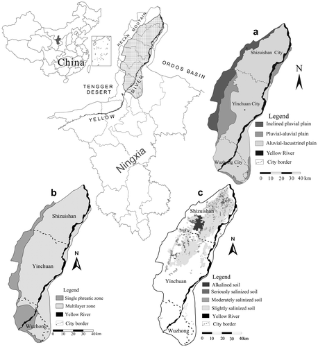
The study area is the Yinchuan Plain, in the northern Ningxia Hui Autonomous Region of North-West China. It is sheltered from the Tengger Desert by the Helan Mountains to the west and bounded by the Ordos Basin to the east (Figure ). It is the largest plain in Ningxia and covers approximately 7790 km2, with elevations ranging from 1100 to 1200 m above mean sea level (Qian, Li, Howard, Yang, & Zhang, Citation2012; Qian, Wu, Zhou, & Li, Citation2014). The Yinchuan Plain consists of three heavily populated cities: Shizuishan in the north, Yinchuan in the centre and Wuzhong in the south.
Figure 1. Location, geomorphology, hydrogeology and soil salinization of the Yinchuan Plain. Adapted from Chen et al. (Citation2016), Qian et al. (Citation2012), Qian and Li (Citation2011), and Wu, Xue, Tian, & Wang (Citation2017b).
The plain has a continental arid to semi-arid climate. It has a dry and dust-laden spring, a hot and humid summer, a cool but short autumn, and a cold and windy winter (Qian et al., Citation2012). The annual mean temperature is 8.92 °C, with the highest temperatures in July and the lowest in January. The average annual precipitation is approximately 185 mm (Qian, Li, Wu, & Zhou, Citation2013). Precipitation is concentrated between June and September. However, the annual rate of evaporation is approximately 1825 mm, which is about 10 times the annual mean precipitation (Qian et al., Citation2012).
The total length of the Yellow River within the plain is 190 km; it is the largest river in the study area, and it has supported agricultural production in the plain for over 2000 years (Chen, Wu, Qian, & Li, Citation2016). The Yellow River enters the plain from the south-west, runs through the plain along the eastern boundary, and exits the plain north-east of Shizuishan (Figure ). The Yellow River transports 100 million m3 of sediment annually and has low salinity, with mean total dissolved solids concentration of 0.4 g/L (Qian et al., Citation2012). The mean runoff of the Yellow River in the plain varies between 1.95 billion and 2.03 billion m3 per year (Wu et al., Citation2008).
Geology and hydrogeology
The Yinchuan Plain is a Cenozoic fault basin covered by approximately 2000 m of unconsolidated Quaternary deposits (Qian et al., Citation2012). Landforms in the plain begin with an inclined pluvial plain in the north-west; then the area transitions to a pluvial–alluvial plain and finally to an alluvial–lacustrine plain (Figure a). The inclined pluvial plain near the foot of Helan Mountain and the south-west area of the plain are covered by relatively thin Quaternary material, which forms a single phreatic aquifer (Figure b). Towards the east, the Quaternary deposits become thicker and support a multi-layer aquifer system, which includes a shallow phreatic aquifer and two confined aquifers within a depth of 250 m (Qian and Li, Citation2011). Aquifers are recharged mainly by leakage from irrigation canals, infiltration of irrigation water, percolation of floodwater during storm events, and boundary inflows. The recharge from precipitation and percolation of the Yellow River is minimal in most areas. It is estimated that leakage from irrigation canals and the infiltration of irrigation water account for over 80% of the total recharge of groundwater (Chen et al., Citation2016). Groundwater discharges in the area are mainly in the form of discharge to drains and to the Yellow River, as well as evaporation and artificial abstraction. Groundwater evaporation is intense in the plain, especially for the phreatic water. This accounts for nearly half of the total groundwater discharge (Chen et al., Citation2016). Artificial abstraction is concentrated in confined aquifers for domestic and industrial purposes, and the phreatic aquifer is rarely extracted for these purposes due to high concentrations of elements that are harmful to the human body and industrial equipment. Groundwater flows from south-west to north-east in the plain. Groundwater-level depth for the phreatic water is usually less than 3 m across the plain, except in the areas where groundwater cones are formed due to heavy exploitation of confined groundwater for domestic and industrial purposes.
Water resources
Although the Yinchuan Plain is in an arid region, it is abundant in water resources, thanks to the Yellow River. According to the Ningxia Water Resources Bulletin (Ningxia Water Resources Department, Citation2017), the total amount of water diverted from the Yellow River for the Yinchuan Plain was approximately 3.8 billion m3 in 2016, over 85% of which was used for irrigation. The available groundwater resources in the plain area were approximately 1.5 billion m3 in 2016, whereas only 340 million m3 was used in 2016. In addition to the water resources diverted from the Yellow River and groundwater resources, there are still local precipitation and reclaimed water resources that can be stored and used for various purposes, such as maintaining ecological functions. Among all sectors, agricultural water demand accounted for 86.1% of the total water resources demand in 2016, which was the largest water demand sector in the plain. A high demand for irrigation water, with low utilization efficiency, is one cause of soil salinization in the plain.
Soil salinization in the Yinchuan Plain and controlling factors
Status of soil salinization in the Yinchuan Plain
The Yinchuan Plain has a dry climate, which made it one of the earliest in the history of China to develop and use water resources (Qian et al., Citation2012). In the Yinchuan Plain, agricultural development is largely dependent on irrigation from the Yellow River. It is widely believed that there would be no agricultural development in Ningxia without the Yellow River. While a large amount of the Yellow River water is diverted for irrigation, the shallow groundwater beneath the plain is rarely used, which results in high groundwater levels, and this leads to serious secondary soil salinization in the context of intense evaporation in this area (Wu et al., Citation2014).
The salinized soil in the Yinchuan Plain currently covers 2.6 million Chinese acres (approximately 1730 km2), which accounts for approximately 53% of the total irrigated farmland in the plain (Wu et al., Citation2008). Soil salinization is the most serious in the northern area of the plain, and this salinized area accounts for over 60% of the total salinized area in the Yinchuan Plain (Figure c). The areas with different degrees of salinized soil are shown in Table . In addition to the salinized soil, there are still over 100 km2 of alkalized soil and over 660 km2 of land that has been deserted due to soil salinization, which demonstrates the seriousness of soil salinization in the plain. Soil salinization has become the main constraining factor for agricultural production in the plain, and it also has negative impacts on the ecological environment and economic development in the plain.
Table 1. Area of salinized soil of different degrees (Wu et al., Citation2008).
Controlling factors of soil salinization in the Yinchuan Plain
Soil salinization in the Yinchuan Plain is controlled by both natural and anthropogenic factors. The natural factors include climate, topography and hydrogeology, which provide the conditions for the formation of soil salinization. However, anthropogenic activities accelerate the process of salinization in the Yinchuan Plain.
Natural factors
The plain belongs to the typical continental arid climate zone, where precipitation is rather limited but evaporation is extremely intense. The typical arid climate in the plain has led to the intense evaporation of shallow groundwater. Due to strong evaporation, the salt moves upwards with water under the effect of capillary stress, which results in the accumulation of salts in the root zone.
Micro-topography affects the degree of soil salinity. The surface elevation in the plain shows a decreasing trend from south to north and from west to east. In particular, the northern part of the plain is the lowest and flattest area, with a slope of 0.18‰ from south to north and 0.67–2.0‰ from west to east. The typical flat and low-lying landforms in the area result in water drainage difficulty. For example, around ponds, lakes and lagoons, heavy salinization is usually formed in the root zone of the low-lying areas.
Soil salinization is also closely related to the hydrogeological settings such as groundwater recharge, depth to groundwater table, and water quality (Wu et al. Citation2014). A shallower groundwater table and higher groundwater salinity can usually induce heavier soil salinization, because shallow groundwater with high salinity will undergo more evaporation, resulting in a greater accumulation of salts in the root zone after evaporation. Groundwater in the north of the plain is more saline than that in the southern part, and the groundwater runoff conditions (water-level depth and groundwater flow rate) in the northern part are also poorer than those in the south, which induces more severe soil salinization in the northern part of the plain.
In addition, the characteristics of the vadose zone lithology play a very important role in the process of soil salinization. In general, soil salinization is more likely to develop in sandy clay and clay distribution areas because of the low permeability of sandy clay and clay, as well as their strong water stagnation and salt accumulation effects (Salama, Otto, & Fitzpatrick, Citation1999). In the Yinchuan Plain, the most serious soil salinization occurred in the flat and low-lying alluvial–lacustrine plain, with the finest particle size being in the vadose zone media. The pluvial–alluvial plain has moderate soil salinization, and the inclined pluvial plain has the least or no soil salinization. The degree of soil salinization decreases when the particle size of the vadose zone media increases from the alluvial–lacustrine plain to the inclined pluvial plain. The spatial distribution trend of soil salinization corresponds well to the hydrogeological settings and landforms in the Yinchuan Plain.
Anthropogenic factors
Apart from natural factors, anthropogenic factors are more important in the development of secondary soil salinization. The Yinchuan Plain has unique advantages in utilizing the Yellow River for irrigation. However, the lack of a scientific agricultural management system has resulted in groundwater level elevation and soil salinization aggravation. In addition, some drainage ditches lack maintenance, and some are broken and collapsed, which has resulted in serious siltation and groundwater level elevation.
According to the statistics of the Ningxia Water Resources Bulletin (Ningxia Water Resources Department, Citation2017), the total amount of water diverted from the Yellow River for irrigation is approximately 4 billion m3 per year, with approximately 60% of it discharged through drains; this is indicative of very low water-use efficiency. Flood irrigation is widely applied in some of the farmlands, resulting in the percolation of large amounts of irrigation water into aquifers and elevation of the groundwater level. However, the abstraction of phreatic groundwater is very minimal in the plain, and the abstraction of phreatic groundwater is only 3.4% of the amount of surface water diversion. Again, this leads to vast shallow groundwater evaporation, which aggravates soil salinization. Therefore, the structure of water resources development must be readjusted, and the proportion of groundwater utilization should be increased to lower the groundwater level and reduce groundwater evaporation.
Conjunctive use of groundwater and surface water to reduce soil salinization
Soil salinization is a water-related problem, which poses significant risks to biodiversity conservation, environmental protection and societal development (Sánchez-Triana, Ortolano, & Paul, Citation2018). An effective way to control the soil salinization in the plain is to use surface water and groundwater conjunctively for irrigation. This will not only prevent soil salinization and improve soil quality but will also reduce the shallow-groundwater evaporation and increase the utilization efficiency of water resources; this effectively addresses the gap between water supply and water demand in the plain.
Scenarios of conjunctive groundwater and surface water use
Under current conditions, farmland in the Yinchuan Plain is irrigated mainly by diverting the Yellow River water through canals (hereafter, canal irrigation). To lower the phreatic groundwater level and reduce groundwater evaporation, scenarios are established in this study in which shallow groundwater is abstracted from wells for agricultural irrigation (hereafter, well irrigation). This will reduce the agricultural demand for surface water. To facilitate decision making in different cities, scenarios were designed for each city with five different proportions of well irrigation (5%, 10%, 15%, 20% and 25%). The proportion represents groundwater abstracted from wells as a percentage of the total irrigation water demand.
These scenarios were simulated by a three-dimensional groundwater flow model based on the MODFLOW platform. This model fully considered the hydrogeological and climatic conditions and was calibrated and verified by groundwater-level monitoring data. The calibration and verification results indicated perfect performance of the model. After model calibration and verification, the designed scenarios and relevant parameters were put into the model, and the model was run until stable results were obtained. The amounts of phreatic water evaporation and groundwater discharge through drains under different scenarios were statistically analyzed, and the area of different groundwater-level depth intervals was calculated. Finally, optimal proportions of well irrigation for different cities in the plain were determined by considering the modelling results and local economic states.
Phreatic groundwater evaporation and discharge through drains under different scenarios
The reductions of phreatic groundwater evaporation and discharge through drains under different scenarios are shown in Figure . In general, the amounts of phreatic groundwater evaporation and groundwater discharge through drains are reduced under different scenarios, and these reductions are greater with the increase of well irrigation proportions. However, the reductions differ between cities. The reduction in groundwater evaporation in any proportion is the greatest in Shizuishan, and it is the smallest in Yinchuan. This may be attributed to the groundwater-level depth in Shizuishan being the shallowest and in Yinchuan, the deepest. Yinchuan is the most populated city on the plain, and the amount of confined groundwater abstraction for domestic and industrial purposes is large. The drawdown in confined aquifers will further lower the water level of an unconfined aquifer. In terms of the reduction in groundwater discharge through drains, it is the highest in Yinchuan and the lowest in Shizuishan.
Figure 2. Reduction of phreatic groundwater evaporation and discharge through drainage ditches under different scenarios: (a) reduction of phreatic groundwater evaporation; (b) reduction of groundwater discharge through drains.
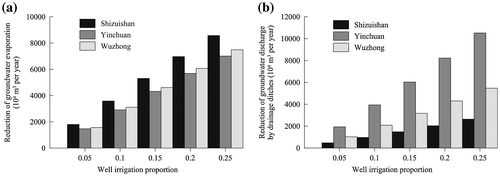
Figure also shows that under 25% well irrigation, the reduction of total phreatic water evaporation in the entire plain reaches approximately 2.3 × 10⁸ m3/y, and the reduction of the total discharge by drains is approximately 1.9 × 10⁸ m3/y. This indicates that the combination of well irrigation and canal irrigation can effectively reduce the evaporation of shallow groundwater and improve the utilization efficiency of water resources. The amount of salts accumulated in the root zone can be reduced because of the reduction in groundwater evaporation. In addition, the decrease in groundwater discharge through the drains can ease the drainage load of the drains and lower the maintenance cost accordingly.
Groundwater-level depth under different scenarios
Under different scenarios, the area of different groundwater-level depths also varies. In the Yinchuan Plain, the threshold depth of groundwater evaporation is 3 m below the ground surface (Wu et al., Citation2008). When the groundwater-level depth is more than 3 m, there will be very limited evaporation. In this study, simulated groundwater-level depth was further divided evenly into six intervals for analysis. Figures show the variation in area with different water-level depths under different scenarios in different cities. The results can be briefly summarized based on the figures.
Figure 3. Variation in area for different groundwater-level depth intervals under different scenarios in Shizuishan, for groundwater-level depth within (a) 0–0.5 m, (b) 0.5–1.0 m, (c) 1.0–1.5 m, (d) 1.5–2.0 m, (e) 2.0–2.5 m, and (f) 2.5–3.0 m.
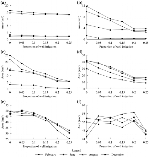
Figure 4. Variation in area for different groundwater-level depth intervals under different scenarios in Yinchuan, for groundwater-level depth within (a) 0–0.5 m, (b) 0.5–1.0 m, (c) 1.0–1.5 m, (d) 1.5–2.0 m, (e) 2.0–2.5 m, and (f) 2.5–3.0 m.
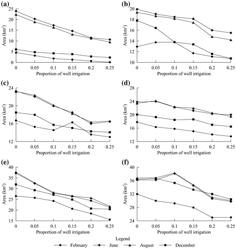
Figure 5. Variation in area for different groundwater-level depth intervals under different scenarios in Wuzhong, for groundwater-level depth within (a) 0–0.5 m, (b) 0.5–1.0 m, (c) 1.0–1.5 m, (d) 1.5–2.0 m, (e) 2.0–2.5 m, and (f) 2.5–3.0 m.
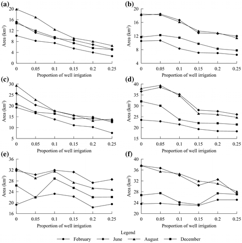
The groundwater levels in all cities have declined to a certain extent because of well irrigation, which is indicated by the decreasing trend in groundwater-level depth in all water-level intervals.
The groundwater level during the irrigation periods (May to September and November of each year) is generally higher than in non-irrigation periods (January to April, October and December of each year) for various well irrigation proportions. For example, at the proportion of 10%, the area with a groundwater-level depth of less than 2 m accounts for approximately 34% of the total irrigation area in September, and only 28% in January.
With an increase in the well irrigation proportion, the area with a greater water depth also increases. This demonstrates that higher well irrigation proportions can effectively lower the groundwater level more than smaller proportions. In theory, this also implies that higher well irrigation proportions are more beneficial for preventing and curing soil salinization if other factors are not considered. However, this is not the case in practice. Other factors such as the irrigation cost and ecological conservation should also be fully considered. Therefore, an optimal well irrigation proportion should be determined for cities.
Optimal proportion of well irrigation for cities
In theory, a higher well irrigation proportion can achieve better soil salinization control. However, the cost of irrigation, as well as ecological and economic factors, should be considered to achieve cost-effective benefits. Therefore, an optimal well irrigation proportion should be determined. The purpose of determining the optimal well irrigation proportion is to reduce soil salinity by lowering the phreatic water level at an acceptable cost.
The threshold depth for groundwater evaporation is 3 m in the plain. If this threshold were used as a unified standard for lowering the water level over the entire plain, the cost would be huge, and farmers cannot afford it. But the evaporation of groundwater decreases exponentially with increasing groundwater depth. In the Yinchuan Plain, when the water-level depth is more than 2 m, the evaporation of the phreatic water will be very small, according to the results of soil salinization treatment experiments in the northern part of the plain (Wu et al., Citation2008). When the groundwater-level depth is controlled at approximately 2 m in the plain, crop growth will not be affected by the salinity, and soil salinization problems can generally be solved. Therefore, a reasonable well irrigation proportion can be determined for different cities based on the criterion that the area of groundwater-level depth of less than 2 m is greatly reduced.
Shizuishan is in the northern area of the plain, and geographically, it belongs to the groundwater drainage zone. Groundwater runoff is slow, and the groundwater-level depth is small. Areas with a water-level depth of less than 2 m cover 26–30% of the farmland in the city during the irrigation period. When the well irrigation proportion increases from 0 to 20%, the area with a water-level depth of 0–0.5, 0.5–1.0, 1.0–1.5 and 1.5–2.0 m shows an obvious decrease (Figure , a–d). However, when the proportion increases from 20% to 25%, the area of the abovementioned water-level depths does not change much, but the area of 2.0–2.5 and 2.5–3.0 m decreases sharply (Figure , e and f). This implies that when the groundwater level declines to a certain extent, it is very difficult to further reduce the water level in these areas; this is because at this moment, most of the areas with a water-level depth of less than 2.0 m are located near the diversion channels, drains and lakes, and these surface water bodies can recharge groundwater. Further water pumping can only reduce the water level in areas where the water-level depth is already more than 2 m, and this has little practical meaning in controlling soil salinization. A further increase in the proportion will increase the irrigation cost for farmers. Thus, the reasonable well irrigation proportion for Shizuishan is 20–25%.
Yinchuan is in the central part of the plain. The area of groundwater-level depth of less than 2.0 m accounts for 35.7–39.6% of its total agricultural area during the irrigation period. When the well irrigation proportion increases from 0 to 20%, the area of water-level depth within 0–0.5, 0.5–1.0, 1.0–1.5, and 1.5–2.0 m decreases significantly (Figure , a–d), but when the proportion increases from 20% to 25%, the decreasing trend tends to be smaller. When the proportion increases from 20% to 25%, the curves for June and August show a significant downward trend (Figure e). This indicates that the area of water-level depth within 2.0–2.5 m decreases sharply, and a high well irrigation proportion tends to have greater effects on areas of greater water-level depth, as in Shizuishan. Based on the trend of each curve in Figure , the reasonable well irrigation proportion for Yinchuan is 20–25%.
Wuzhong is in the southern part of the plain. The area of groundwater table depth of less than 2.0 m accounts for 26.8–28.8% of the irrigated farmland during the irrigation period. When the well irrigation proportion increases from 0 to 15%, the area for water-level depth within 0–0.5, 0.5–1.0, 1.0–1.5 and 1.5–2.0 m decreases significantly (Figure , a–d). However, when the proportion increases from 15% to 25%, the decreasing trend becomes gentle. As seen in Figure (e and f), the curves do not show a clear increasing or decreasing trend. Based on the curves in Figure , the reasonable well irrigation proportion in Wuzhong is 15–20%.
The optimal well irrigation proportions determined on the basis of the simulation results are in accordance with the actual situation in the Yinchuan Plain. In the northern area of the plain, soil salinization is serious, with high groundwater levels and poor groundwater flow conditions. Therefore, the proportion is greater than that in the cities in the southern area of the plain, where the groundwater table depth is greater and soil salinization is weaker. According to the simulation results, the area of water-level depth of less than 2 m decreased by 30.83% compared with the conditions with no well irrigation, which implies that the conjunctive use of canal irrigation and well irrigation at the optimal well irrigation proportions can lower the groundwater level and reduce groundwater evaporation. Thus, the soil salinization issues in the plain are improved at an acceptable cost.
Additional considerations to reduce soil salinization
Soil salinization is one of the major problems that affect crop production in the Yinchuan Plain, especially in the northern part. This issue has restricted social and economic development in the plain for many years. Considering the political power of Chinese governments at all levels, scientific decision making is the first step towards sustainable agriculture and sustainable development of water resources (Mwamakamba et al., Citation2017). On the one hand, it is necessary to take effective measures to further lower the groundwater and increase water-use efficiency in the plain; and on the other hand it is helpful to enhance scientific research in Integrated Water Resources Management and reducing soil salinization. To improve the current serious situation of soil salinization in the study area, furthering lowing the groundwater level, increasing water-use efficiency, strengthening scientific research, establishing regular and comprehensive monitoring, promoting close cooperation among the different departments, countries and organizations, and setting up an effective data-sharing platform are highly recommended.
Further lowering groundwater level and improving water-use efficiency
As high groundwater level is the key factor affecting soil salinization in the Yinchuan Plain, lowering the groundwater to reduce evaporation of groundwater should always be given top priority. It is necessary to improve the drainage systems and dredge the drainage ditches regularly. Most importantly, the combination of canal irrigation and well irrigation, as suggested in this study, should be implemented as soon as possible. In terms of the low-lying areas where groundwater-level depth is shallow and soil salinization is very severe, targeted drainage measures should also be implemented in addition to general measures for the entire plain. For example, fish ponds and lacustrine wetlands should be properly protected to reduce their impacts on the surrounding farmland. Reducing lateral water seepage from ponds and lakes to farmland is an effective measure for this issue.
Lowering the groundwater can also be achieved by reducing groundwater recharge and increasing water-use efficiency in the plain. According to the calculated water budget, leakage from irrigation canals and infiltration from irrigation water are the two largest sources of groundwater recharge (Qian et al. Citation2012). Therefore, it is mandatory to carry out canal maintenance to avoid canal leakage and increase the water-use efficiency of canals. Advanced irrigation methods are also necessary, such as drip or sprinkler irrigation, to reduce the amount of irrigation infiltration. Avoiding flood irrigation as much as possible is recommended. More importantly, crop layout must be planned scientifically to reduce the water needed for irrigation. Rice is the most common crop in the plain, but it requires a large amount of water for irrigation and demands perfect drainage systems. It is therefore highly recommended that decision makers encourage farmers to rotate planting of rice and maize, which would help alleviate the salinization problem in the plain. Crops should also be irrigated according to their needs at different stages of their growth. In some local areas, reclaimed water should be used to supplement irrigation water. This will help reduce the amount of water diverted from the Yellow River, increasing water-use efficiency and reducing the burden of drainage. For example, in the Huinong District of Shizuishan, there are large amounts of reclaimed water available in the drainage ditches. The quality of the reclaimed water is generally suitable for irrigation.
Strengthening scientific research
Scientific research is the basis for securing the sustainable development of the agriculture and water resources in the Yinchuan Plain (Chen et al. Citation2016). However, the current scientific research on Integrated Water Resources Development and soil salinization in the plain is quite limited. Compared with developed areas in China and developed countries, the Yinchuan Plain faces many critical issues to address. There is still big gap between theory and practice, which constrains the reduction of soil salinization in the plain. In particular, the interactions between soil and various water bodies in the plain are still not well understood. This makes it challenging to find efficient soil salinization reduction measures.
Thus, scientific research should be strengthened to attain a better understanding of the mechanisms of soil salinization under different climates and soil types. Certainly, soil salinization research is a multidisciplinary and interdisciplinary field involving hydrology, hydrogeology, soil science, climate science, ecology and biology. The improvement of soil salinization depends on expertise from these disciplines. In addition, advanced techniques and modern technologies such as interferometric synthetic-aperture radar and the Gravity Recovery and Climate Experiment (GRACE) should be further adopted and applied in soil salinization research (Hamidov, Helming & Balla, Citation2016; Harti, Lhissou, Chokmani, Ouzemou, Hassouna, Bachaoui, & Ghmari, Citation2016).
Improving the monitoring network
Soil salinization is always changing, as its causes keep changing. Therefore, it should be monitored regularly. In the study area, local governments have established a very good groundwater monitoring network, and groundwater level and quality are regularly monitored. However, soil salinization is regarded as less important than groundwater and thus is rarely monitored. In fact, soil actively interacts with water and affects water quality. It also affects the safety of food production. Therefore, more attention should be paid to soil salinization monitoring.
Under these conditions, there is an urgent need to set up a scientific monitoring system and establish a base for soil salinization research in the study area to get a better understanding of the evolution of soil salinization and its causes. Soil salinity, soil temperature, water content, and contents of soluble salts should be frequently monitored. This will provide data on the evolution of soil salinity, which will instruct agricultural production. These data are also useful for decision makers and practitioners to take necessary measures to prevent and control soil salinization. More importantly, the soil salinization monitoring data should be combined with the groundwater monitoring data to establish a comprehensive early warning system. The effectives and efficiency of the comprehensive early warning system significantly depends on reliable data and an information system that easily stores and integrates these data.
Enhancing cooperation and data sharing
In addition to regular monitoring, collaboration is also very important in scientific research. To solve the water resources problem and the soil salinization problem in the plain, collaboration between researchers from different provinces, nations and organizations should be encouraged so that scientists can work together to solve these international problems. In particular, local researchers should seek help from international scholars who are experienced in water resources management and soil salinization studies. The International Water Association has numbers of members who are experts in this field, and South Africa, Israel and Singapore all have experience in Integrated Water Resources Management. Local governments are encouraged to collaborate with these countries and organizations. In addition, the local governments should financially support some research projects to study the evolution of soil salinization and its relations to human activities and natural environmental changes.
Data sharing can raise the efficiency of scientific research and policy making. At present, there are some local institutes focusing on assessments of soil salinization. Separately, these researchers have some very limited data on soil salinity, but these data are never shared. Without data sharing, both research and decision making will be less efficient. It would be helpful if the local Land and Resources Department could establish an effective data-sharing platform, through which researchers, government officials and the public would have access to all data on water resources and soil properties.
Conclusions
Soil salinization is a serious issue in the Yinchuan Plain due to high groundwater level and intense groundwater evaporation. This has largely hampered the sustainable development of local economy and the success of the Belt and Road Initiative. Approximately 53% of the total irrigated farmland in the plain is covered by salinized soil, and that is in addition to over 100 km2 of alkalized soil and over 660 km2 of deserted land. The serious soil salinization is due to the water resources in the plain not being scientifically developed, and thus, this should urgently be improved. To achieve this goal, the conjunctive use of surface water and groundwater was proposed in this study to increase the groundwater-level depth, and five scenarios were designed for each city, which were simulated using a well-calibrated and verified model. The conjunctive use of surface water and groundwater for irrigation in the plain is an effective and efficient way to alleviate the soil salinization problem there. This can lower the groundwater level and reduce the accumulation of salts in the root zone, while also maintaining high agricultural production at an acceptable cost. This would also reduce shallow groundwater evaporation and discharge through drains, raising water resource utilization efficiency. Finally, sustainable water resources management and soil salinization improvement can be achieved through interdisciplinary measures that range from improving drainage systems and increasing water-use efficiency to establishing regular salinization monitoring, as well as enhancing data sharing and collaborative research on soil salinization.
Disclosure statement
The authors declare that they have no competing interest.
Funding
The study is jointly supported by the National Natural Science Foundation of China [grant numbers 41502234, 41602238, 41572236, 41761144059]; Foundation of Outstanding Young Scholar of Chang’an University [grant number 310829153509]; Research Funds for Young Stars in Science and Technology of Shaanxi Province [grant number 2016KJXX-29]; General Financial Grant from the China Postdoctoral Science Foundation [grant numbers 2015M580804 and 2016M590911]; Special Financial Grant from the China Postdoctoral Science Foundation [grant numbers 2016T090878 and 2017T100719]; Special Financial Grant from the Shaanxi Postdoctoral Science Foundation [grant numbers 2015BSHTDZZ09 and 2016BSHTDZZ03]; Special Fund for Basic Scientific Research of Central Universities [grant numbers 310829161014, 310829173306, 310829173701, 310829172202].
Acknowledgments
We are grateful to the reviewers and the editor for their constructive suggestions, which have helped us a lot in improving the quality of the paper.
References
- Acosta, J. A., Faz, A., Jansen, B., Kalbitz, K., & Martínez-Martínez, S. (2011). Assessment of salinity status in intensively cultivated soils under semiarid climate, Murcia, SE Spain. Journal of Arid Environments, 75(11), 1056–1066. doi:10.1016/j.jaridenv.2011.05.006
- Aragüés, R., Medina, E. T., Zribi, W., Clavería, I., Álvaro-Fuentes, J., & Faci, J. (2015). Soil salinization as a threat to the sustainability of deficit irrigation under present and expected climate change scenarios. Irrigation Science, 33(1), 67–79. doi:10.1007/s00271-014-0449-x
- Chen, J., Wu, H., Qian, H., & Li, X. (2016). Challenges and prospects of sustainable groundwater management in an arid region along the Silk Road economic belt, northwest China. International Journal of Water Resources Development. doi:10.1080/07900627.2016.1238348
- Daliakopoulos, I. N., Tsanis, I. K., Koutroulis, A., Kourgialas, N. N., Varouchakis, A. E., Karatzas, G. P., & Ritsema, C. J. (2016). The threat of soil salinity: A European scale review. Science of The Total Environment, 573, 727–739. doi:10.1016/j.scitotenv.2016.08.177
- El Harti, A., Lhissou, R., Chokmani, K., Ouzemou, J., Hassouna, M., Bachaoui, E. M., & El Ghmari, A. (2016). Spatiotemporal monitoring of soil salinization in irrigated Tadla Plain (Morocco) using satellite spectral indices. International Journal of Applied Earth Observation and Geoinformation, 50, 64–73. doi:10.1016/j.jag.2016.03.008
- Haj-Amor, Z., Hashemi, H., & Bouri, S. (2017). Soil salinization and critical shallow groundwater depth under saline irrigation condition in a Saharan irrigated land. Arabian Journal of Geosciences, 10(14), 301. doi:10.1007/s12517-017-3093-y
- Hamidov, A., Helming, K., & Balla, D. (2016). Impact of agricultural land use in Central Asia: A review. Agronomy for Sustainable Development, 36(1), 6. doi:10.1007/s13593-015-0337-7
- Howard, K. W. F., & Howard, K. K. (2016). The new “Silk Road Economic Belt” as a threat to the sustainable management of Central Asia’s transboundary water resources. Environmental Earth Sciences, 75(11), 976. doi:10.1007/s12665-016-5752-9
- Ibrahimi, M. K., Miyazaki, T., Nishimura, T., & Imoto, H. (2014). Contribution of shallow groundwater rapid fluctuation to soil salinization under arid and semiarid climate. Arabian Journal of Geosciences, 7(9), 3901–3911. doi:10.1007/s12517-013-1084-1
- Ibrakhimov, M., Khamzina, A., Forkutsa, I., Paluasheva, G., Lamers, J. P. A., Tischbein, B., … Martius, C. (2007). Groundwater table and salinity: Spatial and temporal distribution and influence on soil salinization in Khorezm region (Uzbekistan, Aral Sea Basin). Irrigation and Drainage Systems, 21(3–4), 219–236. doi:10.1007/s10795-007-9033-3
- Jesus, J., Castro, F., Niemelä, A., Borges, M.-T., & Danko, A. S. (2015). Evaluation of the impact of different soil salinization processes on organic and mineral soils. Water, Air, & Soil Pollution, 226(4), 102. doi:10.1007/s11270-015-2373-y
- Li, P. (2016). Groundwater quality in Western China: Challenges and paths forward for groundwater quality research in Western China. Exposure and Health, 8(3), 305–310. doi:10.1007/s12403-016-0210-1
- Li, P., Qian, H., Howard, K. W. F., & Wu, J. (2015). Building a new and sustainable “Silk Road economic belt”. Environmental Earth Sciences, 74(10), 7267–7270. doi:10.1007/s12665-015-4739-2
- Li, P., Qian, H., & Zhou, W. (2017b). Finding harmony between the environment and humanity: An introduction to the thematic issue of the Silk Road. Environmental Earth Sciences, 76(3), 105. doi:10.1007/s12665-017-6428-9
- Li, P., Tian, R., Xue, C., & Wu, J. (2017a). Progress, opportunities and key fields for groundwater quality research under the impacts of human activities in China with a special focus on western China. Environmental Science and Pollution Research, 24(15), 13224–13234. doi:10.1007/s11356-017-8753-7
- Li, P., Wu, J., & Qian, H. (2016). Regulation of secondary soil salinization in semi-arid regions: A simulation research in the Nanshantaizi area along the Silk Road, northwest China. Environmental Earth Sciences, 75(8), 698. doi:10.1007/s12665-016-5381-3
- Mwamakamba, S. N., Sibanda, L. M., Pittock, J., Stirzaker, R., Bjornlund, H., van Rooyen, A., … Kashaigili, J. J. (2017). Irrigating Africa: Policy barriers and opportunities for enhanced productivity of smallholder farmers. International Journal of Water Resources Development, 33(5), 824–838. doi:10.1080/07900627.2017.1321531
- Ningxia Water Resources Department. (2017). Ningxia Water Resources Bulletin. Retrieved from http://218.95.174.123/pub/NXSLTGW05/SLFW_4393/SLGB/SZYGB/201711/P020171113341276782503.pdf (in Chinese).
- Qian, H., & Li, P. (2011). Hydrochemical characteristics of groundwater in Yinchuan Plain and their control factors. Asian Journal of Chemistry, 23(7), 2927–2938.
- Qian, H., Li, P., Howard, K. W. F., Yang, C., & Zhang, X. (2012). Assessment of groundwater vulnerability in the Yinchuan Plain, Northwest China using OREADIC. Environmental Monitoring and Assessment, 184(6), 3613–3628. doi:10.1007/s10661-011-2211-7
- Qian, H., Li, P., Wu, J., & Zhou, Y. (2013). Isotopic characteristics of precipitation, surface and ground waters in the Yinchuan plain, Northwest China. Environmental Earth Sciences, 70(1), 57–70. doi:10.1007/s12665-012-2103-3
- Qian, H., Wu, J., Zhou, Y., & Li, P. (2014). Stable oxygen and hydrogen isotopes as indicators of lake water recharge and evaporation in the lakes of the Yinchuan Plain. Hydrological Processes, 28(10), 3554–3562. doi:10.1002/hyp.9915
- Salama, R., Otto, C., & Fitzpatrick, R. (1999). Contributions of groundwater conditions to soil and water salinization. Hydrogeology Journal, 7(1), 46–64. doi:10.1007/s100400050179
- Sánchez-Triana, E., Ortolano, L., & Paul, T. (2018). Managing water-related risks in the West Bengal Sundarbans: Policy alternatives and institutions. International Journal of Water Resources Development, 34(1), 78–96. doi:10.1080/07900627.2016.1202099
- Sternberg, T. (2016). Water megaprojects in deserts and drylands. International Journal of Water Resources Development, 32(2), 301–320. doi:10.1080/07900627.2015.1012660
- Wang, H., & Jia, G. (2012). Satellite-based monitoring of decadal soil salinization and climate effects in a semi-arid region of China. Advances in Atmospheric Sciences, 29(5), 1089–1099. 10.1007/s00376-012-1150-8
- Wu, J., Li, P., Qian, H., & Fang, Y. (2014). Assessment of soil salinization based on a low-cost method and its influencing factors in a semi-arid agricultural area, northwest China. Environmental Earth Sciences, 71(8), 3465–3475. doi:10.1007/s12665-013-2736-x
- Wu, X., Qian, H., Yu, D., Zhang, Q., Yan, Z., & Wang, W., … Zhao, Q. (2008). Investigation and Assessment of Rational Allocation of Groundwater Resources in the Yinchuan Plain. Beijing: Geologic Publishing House . (in Chinese).
- Wu, J., Wang, L., Wang, S., Tian, R., Xue, C., Feng, W., & Li, Y. (2017a). Spatiotemporal variation of groundwater quality in an arid area experiencing long-term paper wastewater irrigation, northwest China. Environmental Earth Sciences, 76(13), 460. doi:10.1007/s12665-017-6787-2
- Wu, J., Xue, C., Tian, R., & Wang, S. (2017b). Lake water quality assessment: A case study of Shahu Lake in the semiarid loess area of northwest China. Environmental Earth Sciences, 76(5), 232. doi:10.1007/s12665-017-6516-x