
Abstract
Extensive scientific ocean drilling in the Australasian region for 50 years has generated public-domain geoscience knowledge on a scale that no other science program could. Predominantly continuous coring, commonly to depths of 1000 m or more below the sea bed, has revealed the nature and origin of the continental margins, the plateaus and ridges, and the deep ocean, and put them into their plate-tectonic context. Many Australian and New Zealand scientists have played important roles in the 50 two-month regional expeditions, including building the international proposals that led to them. Large International teams aboard ship exchanged ideas and often formed long-term scientific partnerships. Most are not formally marine geoscientists or marine microbiologists. Scientists from Australia and New Zealand were also involved in numerous expeditions outside this region, but this is not their story. There have been ground-breaking results addressing global questions, such as the nature and history of plate tectonics, subduction zones and island arcs, spreading centres and polymetallic ore deposits, ocean basins and ridges, and subseafloor microbiology. Without this research, relatively little would be known about the geological history of the oceans and indeed of the continents over the last ca 150 million years. The most widely researched field has been oceanographic and climate history, which depends on plate-tectonic configuration, the thermal circulation from the Equator to the poles, and the links and constraints of deep-water circulation in the oceans. The change from a generally warm globe during the existence of Gondwana to a cooling globe after Antarctica became isolated from the rest of that supercontinent at about 33 Ma, when the deep-water Antarctic Circumpolar Current developed, cutting off the warm water and leading to a complete reorganisation of oceanic currents. Microbiological studies have shown that large communities of microbes occur deep within oceanic sediments, and also where hot fluids vent from young oceanic spreading centres and submarine island arcs.
Lithospheric plate creation and destruction is outlined in the Australasian region.
The history of the isolation of Antarctica, icehouse and global current systems are summarised.
Mantle plume (hotspot) evolution is presented.
Feeder zones of hydrothermal systems and their novel biology are given.
KEY POINTS
Introduction
The floors of the oceans are intrinsically important in terms of understanding our planet’s most extensive crustal type on time-scales of ca 100 million years. The oceanic crust is predominantly formed by igneous activity, and together with the underlying lithosphere, it is recycled back into the Earth’s mantle. Dispersal and accretion of continental masses accompanies this crust-forming and destruction process. The oceans and seas are also the repository of sediments derived from continents and the remains of biological activity in the oceans that are modulated by the coupled changes in ocean–atmosphere systems. This provides an overview of results arising from coring the floors of the oceans and seas of the world by international scientific ocean drilling, driven by the importance of this vast realm to our planet.
We focus primarily on expeditions in the Australasian region, but also outline the development of this global scientific endeavour, and the evolution of its individual scientific programs, noting a current emphasis on hypothesis testing. There have been more than 50 expeditions in the Australasian region since the early 1970s (). The volume of literature resulting from these programs is daunting, so we have attempted to guide interested readers to the relevant Internet sources for reports, primary papers and information in the Australasian region. The regional coverage features brief expedition summaries and provides an overview for readers with targeted scientific or economic interests.
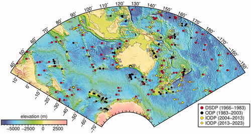
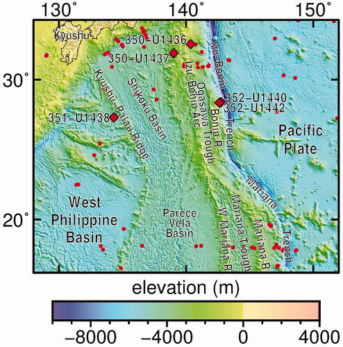
Figure 1. Regional map showing all regional scientific ocean drilling from 1968 to 2018, superimposed on tectonic structure as illustrated by bathymetry. Courtesy of Ron Hackney.
Scientific ocean drilling is a great 50-year success story of collaborative international science. Without ocean drilling, our understanding would be drastically poorer in areas such as climate change; oceanographic changes including the establishment of major currents and water masses; complete evaporation of some seas; the Paleogene onset of Antarctic glaciation; the evolution of marine organisms; establishment of an orbitally calibrated, absolute time-scale; documentation of unequivocally global sea-level changes; and the history of the Great Barrier Reef. Other themes include the formation of spreading ridges and basins, island arcs, hotspot chains and large igneous provinces; mountain building events; and development of hydrocarbon-hosting clathrates (gas hydrates). Further themes include the study of the unique microbiota within deep-sea fluid vents and beneath the sea bed; seafloor mineralised hydrothermal systems; giant impacts such as the end-Cretaceous–Paleogene event; and the drivers of fast and slow earthquakes, which can have massive impacts on human society.
The international scientific ocean drilling program came into existence in 1966 with the USA-funded Deep Sea Drilling Project (DSDP). Over time, ocean drilling has gone through three more incarnations, starting with the Ocean Drilling Program (ODP) from 1983 to 2003. Two later phases both operated under the acronym of IODP; the first of these (2003 to 2013) was the Integrated Ocean Drilling Program and the second (current phase) is the International Ocean Discovery Program, continuing from 2013 until 2023. We will refer for convenience to these two phases as IODP1 and IODP2, respectively.
Deep-sea drilling platforms and instrumented boreholes are the fundamental scientific tools used by these programs to recover materials from below the sea floor for detailed laboratory studies, and to monitor physical conditions and fluid characteristics of the oceanic crust. The technology has improved dramatically over the years, so that an expanded geographic range is targetable, a wider variety of crustal environments and penetration depths can be tackled, continuous stratigraphy can be recovered, an expanded range of materials from soft sediment to hard rock types retrieved, and intra-formation gases (e.g. methane in clathrates) can be sampled in situ.
This longest-lasting and largest international geoscience research program has a current annual operating budget for direct costs of ∼US$180 million. Its aim has always been to drill the sequences beneath the sea bed because there the diversity of Earth’s history is better preserved for the last ca 150 million years than anywhere else. The programs have always been curiosity-driven, all results released into the public domain, and the programs’ success scrutinised and judged by scientific publications and by funding agencies. Although this is a pure science program, many of the results are also important for national and international jurisdictional issues and resources, including hydrocarbon and mineral exploration. Many of the discoveries of the successive programs have become widely embedded in geoscientists’ global views of the Earth, often without explicit recognition of the origins of this knowledge.
Overview and more detailed maps of portions of the Australasian region, spanning 35°E to 145°W, and 15°N to 75°S, are presented. The region encompasses much of the present Australia–India tectonic plate, and portions of the former partners in the Gondwana supercontinent. The overview map () shows all the sites in their bathymetric and tectonic settings. Clearly, the Australasian region has benefited from the range and scope of scientific ocean drilling. Later regional maps display the drill sites explored by the individual programs (DSDP, ODP, and IODP1/2). The wide distribution of DSDP sites documents the exploratory character of this first stage of scientific ocean drilling. The ODP site distribution was driven by specific themes in a deliberately global coverage, while both IODP phases have been pursuing themes in more tightly focussed areas. The site distributions reflect an evolving and maturing scientific program. Noting the thematic emphasis of paleoceanography in IODP2 (see below) and the need for good foraminiferal preservation, the current program has largely moved out of the deep basins.
Australian and New Zealand geoscientists, here defined as scientists of any nationality based in the two countries, have been shipboard and post-expedition participants since the early days. In recent years, they have frequently been key proponents (proposal writers) of expeditions, especially in the Australasian region, and some have also been co-chief scientists on a number of expeditions. In the co-chief scientist’s role, they have helped steer the shipboard program and the post-expedition science. More recently, with a broadening of scientific themes and outreach, geobiologists and educators have been involved in the planning and execution of expeditions.
Two freely available e-books have reviewed Australian involvement in scientific ocean drilling, emphasising expeditions within the region outlined in . We draw heavily on these books in the sections below. The first book (Baker & Keene, Citation2004) covered Australia’s involvement in ODP (1988–2003). Thirteen expeditions were in waters of Australian jurisdiction and another four in our general region. Sixty Australian scientists participated in expeditions, and seven of them were co-chief scientists. New Zealanders were involved, but New Zealand was not a member so the book did not cover their contributions. It is worth noting that the Australian contribution to the total operational costs of these ODP expeditions was about A$20 million out of a total cost of about US$120 million. This type of financial leverage has continued to the present.
The second book (Exon, Citation2017) covered involvement by Australia and New Zealand in IODP1 (Australia and New Zealand IODP Consortium—ANZIC) from 2008 to 2013 and on through the beginning of IODP2. There were five expeditions in the Australasian region until 2013, and 13 more germinated from two regional workshops initiated by ANZIC; these were completed during IODP2.
Altogether, the expeditions have led to an enormous increase in our understanding of geological and climatic history and the nature of basement rocks, and to a great leap forward in our understanding of biostratigraphic and oceanographic changes.
Scientific ocean drilling: the background facts
The worldwide history and achievements of scientific ocean drilling have been reported by various authors over the years (e.g. Maxwell, Citation1993; Munk, Citation1980; Revell, Citation1981; Smith et al., Citation2010; Stein et al., Citation2014; Winterer, Citation2000). The latest reviews, presented in a special volume of Oceanography (Becker et al., Citation2019), inform much of the following account.
Bascom (Citation1961) outlined the history of the Mohole Project, which was the starting-point for all scientific ocean drilling. This project was conceived in 1957 (e.g. Lill & Maxwell, Citation1959), and optimistically planned to drill through the Mohorovičić Discontinuity at the base of oceanic crust (generally 6–7 km thick) into the mantle. In 1961, the National Science Foundation of the USA funded the hire of a drilling barge CUSS I (named after the oil companies, Continental, Union, Superior and Shell that supported its development), operated as the world’s first dynamically positioned drilling vessel (). The Project cored 170 m of sediments and a few metres of underlying basalt at a deep-water (3600 m) site off Baja California. A geochemical analysis of this basalt was published by Engel and Engel (Citation1961).
Figure 2. (a) The world’s first dynamically positioned, deep-sea drilling barge, CUSS-1. The ship succeeded in penetrating to Layer 2 of the oceanic crust, recovering basalt, in the Pacific Ocean offshore of Baja California. (b) Harry Hess explaining the concept of the Mohole.
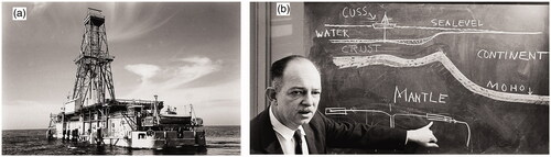
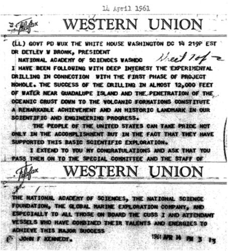
Huge public interest was generated by a major article about the project in Life magazine by novelist John Steinbeck (Steinbeck, Citation1961). Recovering subseafloor basalt was a major scientific accomplishment at the time, and it inspired a congratulatory telegram from President John F. Kennedy ().
Figure 3. Recovering sub-seafloor basalt was a major scientific accomplishment at the time, and it inspired a congratulatory telegram from President John F. Kennedy.
Deep Sea Drilling Project
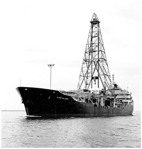
From 1968 to 1983, the DSDP explored the deep ocean’s sediments and rocks using the 122 m-long, purpose-built scientific drill ship Glomar Challenger (). The DSDP was funded by the National Science Foundation of the USA (NSF), but welcomed scientists from other nations, including Australians and New Zealanders, to its drilling campaigns. The review of the DSDP at http://deepseadrilling.org/about.htm states “Through contracts with Joint Oceanographic Institutions, Inc. (JOI), NSF supported the extensive scientific advisory structure for the project and funded predrilling geophysical site surveys. Scientific planning was conducted under the auspices of the Joint Oceanographic Institutions for Deep Earth Sampling (JOIDES).” The Scripps Institution of Oceanography on the US west coast was responsible for the management and operations of the program. They stored the cores from many of the expeditions, and Lamont-Doherty Earth Observatory at Columbia University stored the rest on the US east coast.
Figure 4. Glomar Challenger at sea during ODP. Source: JOIDES Resolution Science Operator; Texas A&M University.
This was the pioneering era of ocean exploration through drilling: holes were sited in most parts of the world’s oceans to investigate the nature of ridges, rises, deeps and basins, and to test extant ideas concerning the origins and development of these features. Of major interest was the nature of seismically identified reflectors, given the areal extent of many of these. Holes were commonly spot-cored (so that only some intervals of the rocks penetrated were recovered) rather than continuously cored. Coring by rotary bits was standard, resulting in non-recovery in soft oozes. Drilling depths were normally limited by the life of a single drill bit, and holes seldom exceeded 700 m below the sea floor, although re-entry with a replacement bit was achieved for the first time in 1970.
Comprehensive Initial Reports set out the results from the expeditions. A final review of the program (http://www-odp.tamu.edu/glomar.html) gives the following statistics. The distance travelled was 375 632 nautical miles (∼697 000 km) with drilling at 624 sites. Total penetration was 325 548 m of which 170 043 m was cored, and 97 056 m of core was recovered (core recovery 57%). Altogether 19 119 cores were recovered, the deepest penetration below sea bed was 1741 m, and the maximum basaltic oceanic crust penetration was 1080 m.
By penetrating deeply beneath the floors of the oceans and seas, the Glomar Challenger began the effort to establish the character and evolution of these relatively inaccessible and sparsely explored domains. The major achievements of the DSDP included:
Constraining the age of basalts flanking the southern Mid-Atlantic Ridge, thereby demonstrating increasing age with distance from the ridge consistent with a primary prediction of plate tectonics (Leg 3; Maxwell et al., Citation1970).
Proving that the majority of sub-ocean rocks existing at present have formed in the last 200 million years, and showing that such rocks, dominantly basalt, are continuously erupted at mid-oceanic ridges and destroyed at oceanic trenches. By contrast continental rocks can be billions of years old. Many of the ‘continental rocks’ are, in fact, ancient sedimentary and volcanic rocks that formed in the ocean but have been accreted to the continents. However, slivers and ribbons of submerged continental crust are scattered through some oceans.
Providing a first-order history of climatic and oceanographic changes that have affected the world’s oceans in the last 200 million years.
A summary of the operations of the Glomar Challenger and scientific achievements of the program is provided by Hsü (Citation1992). An account of one of the early expeditions (Leg 13), which discovered the repetitive isolation from the world’s oceans and subsequent evaporation of the Mediterranean Sea during the Miocene, was previously provided by Hsü (Citation1983). More recently, Truswell (Citation2019) has provided, in a free e-book, an illuminating account of a single expedition that sailed to the Southern Ocean (Leg 28; see ). Its results included the dramatic discovery that Antarctic glaciation started 35 million years or more ago, rather than a few million years ago as believed at the time. We note that expeditions were known as “legs” through DSDP and ODP, with the term expedition adopted during IODP1/2.
The DSDP was led and funded solely by the United States until 1975. Recognising the DSDP’s success, other countries asked to join the program and, late in 1975, the International Phase of Ocean Drilling (IPOD) came into being within DSDP, with Leg 45. France, Germany, Japan, the United Kingdom and the Soviet Union became members, but other scientists were still welcomed.
Printing and distribution of the JOIDES Journal began with IPOD and continued during the ODP. It served as a means of communication among the JOIDES committees and advisory panels, NSF and non-US participating organisations, JOI and its subcontractors, and interested Earth scientists. It provided information on JOIDES committees and panels, cruise schedules, science summaries, and meeting schedules.
Ocean Drilling Program
In 1985, a larger (143 m long) and more capable drilling vessel, the JOIDES Resolution () replaced the Glomar Challenger for the ODP. The majority of the funding for ODP was provided by the US National Science Foundation (NSF), but other countries added additional funding, especially 15 European countries in the European Science Foundation Consortium for Ocean Drilling and Japan. The day rate for use of the JOIDES Resolution increased from US$35 000 in 1985 to US$55 000 in 2003, but was less than the rate of inflation could have dictated. NSF’s annual budget for ODP was US$40–50 million between 1994 and 2003.
Figure 5. JOIDES Resolution at the dock in Yokohama, May 2014.
Central management was provided by JOI and, through subcontractors, the full array of services at sea and on land were provided. Texas A&M University served as Science Operator, which included the operations of JOIDES Resolution and the provision of a new core storage facility. Lamont-Doherty Earth Observatory provided logging and other wireline services, and Site Survey Data Bank services. JOI’s responsibilities as Program Manager included management or support of a number of program-related activities, including the Science Advisory Structure for ODP, through the JOIDES office. Scientific direction was provided by JOIDES through an international organisation of advisory committees and panels that provided planning and program advice regarding science goals and objectives, facilities, scientific personnel, and operating procedures.
Australia joined ODP in 1988 in a consortium with Canada, Korea and Taiwan; Australian scientists were heavily involved both before Australia joined and afterwards. By 2003, there were 22 member countries in ODP. Although scientists from member countries took up most positions on vessels, scientists from countries that were not members also participated, especially in their regions of the ocean. New Zealand never joined ODP, but its scientists were often involved.
Continuous coring became mandated. Over time, the routine use of hydraulic piston coring of softer sediments during ODP, with recoveries commonly around 100%, and repeat coring of these sediments to fill gaps between cores, led to greatly increased work on the younger sequences. This phase of ocean drilling aimed to solve specific global scientific problems, unlike the DSDP’s primarily curiosity-driven exploration.
In the transition from DSDP to ODP, the international geoscience community was invited to two planning meetings (Conference on Scientific Ocean Drilling, COSODI and II, in 1981 and 1987, respectively) which led to the first long-range plan for the ODP published in 1990 (http://www.odplegacy.org/program_admin/long_range.html).
In 1996, a second long-range plan was published under the title of Understanding our Dynamic Earth through Ocean Drilling (http://www.odplegacy.org/PDF/Admin/Long_Range/ODP_LRP_1996.pdf). This latter plan set out two major research themes:
Dynamics of Earth’s Environment containing three frontier initiatives:
Understanding Earth’s changing climate
Causes and effects of sea-level change
Sediments, fluids and bacteria as agents of change
Dynamics of Earth’s Interior containing two frontier initiatives:
Exploring the transfer of heat and materials to and from Earth’s interior
Investigating deformation of the lithosphere and earthquake processes
Proposals for ODP drilling were evaluated largely against the two themes and the frontier initiatives. Many scientific questions of global significance were addressed, and the understanding of our geological framework and history increased greatly.
A highly effective committee system steered the science and encouraged and called for drilling proposals from scientific interest groups. Specialist regional and thematic workshops together with program panels, such as those for sediments and geochemical processes, tectonics, lithosphere, and ocean history, fostered and developed drilling proposals (http://www.odplegacy.org/program_admin/sas.html). These proposals were rigorously externally reviewed and only the best led to expeditions; in general, these were of two months duration. Comprehensive volumes of Initial Reports and Scientific Results were prepared for each expedition, and are available (along with citation lists) at http://www-odp.tamu.edu/publications/pubs.htm.
A full final report of the program is at http://www-odp.tamu.edu/publications/ODP_Final_Technical_Report.pdf. The 20 years of operation (6600 days at sea) involved travelling 355 781 nautical miles (∼659 000 km) and included the drilling of 669 sites ( and maps in Introduction to expeditions in the Australasian region and Regional expedition results), of which 376 were wireline-logged. The deepest penetration was 2111 m in a re-entered oceanic basement site. A little over 222 000 m of core were collected and stored at core repositories in the United States (Texas A&M University, Scripps Institution of Oceanography, Lamont-Doherty Earth Observatory of Columbia University), and in Germany (University of Bremen), providing the international scientific community with easy access to the core collection as well as sediment and rock samples for further research. The core storage locations were reorganised when IODP came into existence.
Micropaleontological reference centres were established on four continents, hosted by more than a dozen major institutions. They provide scientists with the opportunity to examine, describe, and photograph microfossils of various geological ages and provenance (http://iodp.tamu.edu/curation/mrc/institutions.html). GNS Science hosts a regional micropaleontological reference centre in Wellington.
Several summaries with highlights of the scientific results of ODP are:
ODP Greatest Hits, http://www.odplegacy.org/PDF/Outreach/Brochures/ODP_Greatest_Hits.pdf
ODP Greatest Hits 2, http://www.odplegacy.org/PDF/Outreach/Brochures/ODP_Greatest_Hits2.pdf
Achievements and Opportunities of Scientific Ocean Drilling. http://www.odplegacy.org/PDF/Admin/JOIDES_Journal/JJ_2002_V28_No1.pdf
Special Issue: The Impact of the Ocean Drilling Program, https://tos.org/oceanography/issue/volume-19-issue-04
IODP in its two incarnations
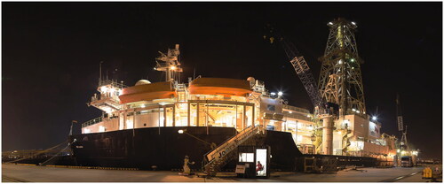
In the early 2000s, the anticipated deployment of a new, highly capable drillship to be supplied by Japan, accompanied by a planned refit of the JOIDES Resolution, inspired reorganisation of the management and planning structure for international scientific ocean drilling. The Integrated Ocean Drilling Program was accordingly established in 2003. In 2007–2008, the JOIDES Resolution was extensively refitted () and returned to scientific drilling service in 2009, while the new riser-equipped drillship, the D/V Chikyu, commenced scientific drilling in 2007 in the Nankai Trough off Japan (our IODP1). The European consortium contributed chartered drilling platforms for specific challenges such as the Arctic Ocean (Expedition 302), and shallow reefs (Expeditions 310 and 325).
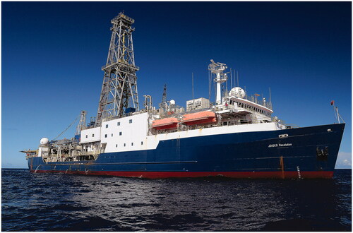
Figure 6. JOIDES Resolution in the Philippine Sea during IODP Expedition 351.
In 2013, management reverted to the primary contributors of the platforms, while the scientific advisory structure, albeit modified from ODP’s, provided advice and expedition ranking to all of the management entities; this phase constitutes IODP2, which started with Expedition 349 in the South China Sea. Summaries of the scientific achievements of IODP1 and IODP2, to date, are given in Stein et al. (Citation2014), and Becker et al. (Citation2019), respectively. Both incarnations of the IODP have been largely funded by the USA, Japan, and Europe, with significant contributions from various associate members. The contribution by the USA to the annual IODP budget has increased steadily through time, to about US$65 million in 2019.
Both phases of the IODP were preceded by major international planning workshops, to which the global community was invited to discuss and identify the leading problems in Earth sciences that could be tackled with the extant deep-sea drilling and coring tools, and borehole monitoring installations. The meeting held in Bremen in 2009, which preceded the commencement of IODP2 by about 4 years, was called IODP New Ventures in Exploring Scientific Targets (INVEST); about 600 scientists attended the meeting. Reports from this workshop are available at https://usoceandiscovery.org/past-workshops-old/iodp-new-ventures-in-exploring-scientific-targets-invest/. The workshops led to the creation of small writing committees (∼dozen scientists with additional ad hoc expertise as required), and publication of two science plans, setting out how the program should be designed and where the scientific emphases should be placed. Both plans focussed on addressing global scientific programs at optimal locations around the globe. As in the ODP, a committee system steered the science, and encouraged and called for drilling proposals. The proposals experienced rigorous review and only the best (a small percentage of total proposals submitted) led to expeditions. We note that in terms of international, collaborative Earth science, expeditions remain primarily driven by proposals from the global community (they are “bottom-up”) and are not mandated by individual governments and their agencies (“top-down”).
Another type of IODP expedition is one carried out as a Complementary Project Proposal (CPP), which requires a strong scientific proposal along with a commitment from a third party, usually a government agency, for substantial financial support. Such expeditions are normally ones of particular interest to individual countries, and a certain number of CPP expeditions are allowed for in IODP’s forward program. This arrangement ensures sympathetic treatment within the proposal system and provides important funding to the ship provider. About half the scientists and one of the two co-chief scientists are selected by the complementary funder.
The first plan, written by Moore et al. (Citation2001), was the Integrated Ocean Drilling Program Initial Science Plan, 2003–2013: Earth, Oceans and Life (http://www.odplegacy.org/PDF/Admin/Long_Range/IODP_ISP.pdf). Proposals for IODP1 drilling were written and evaluated against the three over-arching science themes: 1. The deep biosphere and the subseafloor ocean; 2. Environmental change, processes and effects; 3. Solid Earth cycles and geodynamics.
The second plan, written by Bickle et al. (Citation2011), was the IODP Science Plan 2013–2023: Print Illuminating Earth’s Past, Present, and Future (https://www.iodp.org/about-iodp/iodp-science-plan-2013-2023). Proposals for IODP2 drilling have been and continue to be written and evaluated against four over-arching science themes: 1. Climate and ocean change: reading the past, informing the future; 2. Biosphere frontiers: deep life, biodiversity, and environmental forcing of ecosystems; 3. Earth connections: deep processes and their impact on Earth’s surface environment; 4. Earth in motion: processes and hazards on human time-scales.
Common features of all the scientific plans from the ODP through IODP1 to IODP2 are environmental change (geological record thereof; forcing functions); deep biosphere (of growing significance); creation, modification, and destruction of the lithosphere; interior–exterior fluid interactions and geological hazards and societal impacts.
In IODP1, an integrated management system (IODP-MI) was provided for all platforms, and a new core repository was established in Japan, to complement those long established in the US and Europe. The US, Japan and Europe were financially the major players. Some 12 European countries plus Canada comprised ECORD, the European Consortium for Ocean Research Drilling. Associate Members, who joined the IODP at different stages, were China, Korea, Australia, New Zealand, India and Brazil.
IODP2 has access to the same vessels and core repositories, but no longer has an integrated management system. Each platform provider—the US, Europe, and Japan—manages its own program, but the scientific system is still in common, assuring a coordinated approach. The same membership generally continues. Planning for future subseafloor research after IODP2 ends in 2023 has been completed by the international community. A new “scientific framework” for an international, collaborative endeavour extending to 2050 has been announced (Koppers & Coggon, Citation2020).
Drawing on data presented at the 2019 IODP Forum (overall Program Advisory Committee), in we identify the global thematic proportions by drilling platform, for completed and planned expeditions. Typically, one of these themes dominates the main aims of each expedition but most expeditions have addressed more than one theme. Note that since some expeditions cover more than one theme, the totals for a given platform exceed 100%. This table indicates that stratigraphic drilling of sediments for various purposes has dominated the program; igneous petrological, tectonic and hazards studies are also very prominent; and studies of the deep biosphere are important.
Table 1. Global IODP2 expeditions (2013–2023) covering the various themes.
Australia and New Zealand joined IODP in a consortium in 2008 and have been funded by the Australian Research Council and numerous members—universities and government research agencies—through to the end of 2022. As we are associate members, Australian and New Zealand scientists participate in all international IODP committees, and we have guaranteed access to all expeditions. As noted in various external reviews, our scientific contributions to planning, expeditions, and post-expedition publications—especially in the Australasian region—have been very substantial.
Technological advances
In the 50 years of scientific ocean drilling, since the commencement of the DSDP in 1968, there have been great technological, analytical and theoretical advancements in the many fields that interact to generate successful plans and outcomes in exploration of the floors of the world’s oceans and seas. The concurrent increases in geological understanding of oceanic tectonics, sedimentary sequences and the diversity of basement rocks, have allowed problem-solving to largely replace exploration as the major aim of the research.
The great advances in seismic profiling techniques have been of foundational importance. In the early days, sparse single-channel profiles were recorded on paper, and generally shot with a single small-volume air gun. Crossing lines over a potential drill site were commonly not available until shot by Glomar Challenger itself. Nearly all deep-water lines were shot by research institutes, with industry seismic data generally confined to small areas of the continental shelf. In the 1970s, industry exploration companies (Shell and Gulf Oil, for example) did shoot multichannel seismic lines, during roaming regional studies designed to investigate frontier areas. In the Australian maritime region, these and indeed all surveys come into the public domain by law, and some aided the development of scientific ocean drilling programs. Shipboard magnetic and gravity profiles were also available from various sources and helped in the building of geological understanding.
Modern seismic surveys use large air gun arrays, with individual gun capacities of up to 25 L, very long multichannel cables and immensely capable acquisition systems. Naturally they give much deeper penetration, in some cases to many thousand metres. Development of the sound sources has been complemented by processing and interpretation packages, which allow semi-automated interpretation of seismic lines, and the production of horizon and thickness maps from detailed grids. The improvements in resolution of seismic reflection data have greatly improved the imaging/interpretation of geology, leading to better hazard anticipation and greater safety.
The advent of satellite navigation in the 1970s, and its remarkable development since, was a great boon for all marine geoscience. The locations of geophysical profiles, the sites of rock dredging and sediment cores gathered by research institutions, ocean drilling and other well sites, all became much more accurate, with benefits all around. Dynamic positioning of ocean drilling ships had long had a standard procedure of dropping transponders on the sea bed for triangulation from the ship. Satellite positioning improved site locations to within a few metres, and this was an additional source of location data. The automated positioning of JOIDES Resolution, for example, using a dozen marine thrusters, is now accurate within a metre or two.
In addition, the global data sets available from satellites have made a huge difference in planning and interpretation of ocean science. For example, the maps of sea-surface elevation, temperatures, and chlorophyll have led to a much better definition of how ocean currents behave in general terms and in detail. This is vital information for oceanographers and marine biologists and helps to inform the work of the paleoceanographers and paleobiologists active in ocean drilling. Sandwell and Smith (Citation1992) developed a technique through which sea-surface elevation could be used to generate marine gravity maps. A later paper by Smith and Sandwell (Citation1997) showed that marine gravity could be used to broadly map sea-bed topography across the world’s oceans. The latest versions of these maps are available online in the public domain. These discoveries were huge steps forward for marine geologists. The satellite topographic information data could be controlled by the profiles measured by research vessels, to improve our understanding in many fields, including plate tectonics, and thus assist planning and interpretation of ocean drilling expeditions.
There were great coring advances through time as the program evolved, although the standard rotary drilling technique, with 9.5 m (30 foot) cores, controlled by the length of standard industry drill pipes, remains as it was (see http://iodp.tamu.edu/tools/index.html). Cores are recovered in plastic liners, core diameter is generally around 6.3 cm (2.5 inches), and split cores (working and archive halves) are stored in 1.5 m lengths. The straightforward DSDP rotary coring of Glomar Challenger gave excellent recovery in consolidated and lithified sediments, and variable recovery in hard basement rocks, but was rather ineffective in the sediment oozes in the top ∼200 m of most sites. The introduction of a hydraulic piston corer for Leg 68 in 1979 revolutionised the recovery of soft sediments, with two virtually continuous sections of upper Neogene and Quaternary sediment recovered in the Caribbean Sea and eastern equatorial Pacific Ocean. The DSDP’s reconnaissance drilling, often aimed at defining unconformities visible in the single-channel seismic profiles of the day, commonly used a spot-coring technique that meant that full geological assessments were not possible.
During the ODP, hydraulic piston coring of oozes by JOIDES Resolution gave recovery rates approaching 100%. When complete details of upper Miocene and younger sequences were important, several adjacent holes were drilled to ensure that the inevitable short breaks that occur between cores could be covered, and composite core profiles could be built up that gave full coverage. During IODP, further technological improvements meant that hydraulic piston coring can now be deployed in suitable soft sediments to depths of more than 500 m below sea floor (mbsf). An extended coring system has been developed, whereby a combination of piston coring and rotary coring is used to cope with interbedded strata of differing hardness. This system is variably effective and is used only when it is clearly essential.
Re-entry of ocean drilling sites had been problematic although possible in the early days. Now it is quite routine, and this makes deeper drilling far simpler. However, there remain limitations on JOIDES Resolution drilling, which still generally drills in a hole open to seawater. While the use of some casing and the weight of drilling mud help to stabilise drill holes, there are practical limits to the depths to which the vessel can penetrate before hole collapse makes further progress impossible. This problem is overcome by using the riser-equipped Chikyu, with casing being installed to great depths and pressurised drilling muds recirculated from the bottom of the hole to the ship.
The great advances in well-logging techniques have been a boon; most standard oil industry techniques are available by using exceptionally slim equipment, with some of the industry probes actually developed first for scientific ocean drilling by Schlumberger as primary contractors (https://iodp.tamu.edu/tools/logging/index.html). This technique generally involves logging an open hole, so the logging strings frequently cannot reach the bottom of the hole, and may become stuck and even lost in the hole. JOIDES Resolution and Chikyu can also use a logging-while-drilling technique, with logging tools built into the drilling assembly, if complete logging is essential, but this is more expensive and only a few tools can be deployed.
Mounting geological and geophysical surveys to build drilling proposals
From the late 1950s through into the 1960s, for national strategic reasons, information on the topography, gravity and magnetic characteristics of the ocean floor became important (e.g. Menard, Citation1986). This type of information was vital in the early DSDP explorational phase for choosing potential sites. However, the specific detailed requirements for drilling targets have now increased considerably and finding the vessels to gather all the necessary data to plan drilling programs can be a serious problem. From the initial encouragement by the IODP2 of a proposal until its final acceptance or rejection for an operation normally requires several iterations, with new data acquisition and evaluations often being required.
The need for better targeted sites on expeditions, to address a major scientific problem in a limited geographical/structural region, coincided with great improvements in the quality and abundance of planning data available. Many more countries had institutions investigating regional offshore geology, for pure science, resource and defence reasons, and new advanced research vessels recorded underway gravity and magnetic data, along with ever-improving seismic reflection and refraction data. The advent of digital acquisition and processing systems led to huge advances in data quality and quantity, and ways in which seismic data could be displayed and evaluated. At the same time greatly improved piston-coring techniques on large vessels allowed undisturbed cores, up to 50 m long, to be taken. Global geoscience data sets were assembled from all these surveys and placed in the public domain. At the same time, improved plate-tectonic reconstructions, and the geological understanding that flowed from them, informed all drilling proposals.
During this period, satellites provided ever-better remote sensing of global gravity, sea-surface elevation, and properties such as sea-surface temperature and chlorophyll content, and allowed the development of corresponding maps. An important new technique was the provision of maps showing approximate depth to basement. Another was the development of sonar, multibeam swath-mapping, with swaths up to 20 km wide sewn together to provide maps of unprecedented coverage, bathymetric detail, and acoustic (e.g. back-scatter) character. These data provide enhanced images of the topography surrounding a potential drill site in a time and cost-effective way. In combination with seismic reflection data, scientific insight is generated for understanding geological processes that can affect recovered sections.
From all these data, proposals were formulated that could be carefully evaluated scientifically. The much more detailed site surveys enabled the safety of each proposed site to be considered by an expert panel, with potential hydrocarbon accumulations being avoided at all costs for most expeditions.
Acquiring all the necessary regional geoscience data to build a proposal, and the detailed surveys needed for site selection, are major tasks and require much ship time. Not-ideal site surveys are problematic for the committees reviewing research proposals for vessels. For funding agencies one obvious problem is that detailed site surveys may not finally lead to drilling and may be of limited stand-alone value. They are high-risk and expensive ventures, which may or may not lead to great leaps forward in scientific understanding.
Adding to the problems of modern-day surveys for ocean drilling purposes is a general reduction in the number of research vessels capable of recording deep-penetration multichannel seismic data. The RV Investigator (operating for Australia’s Marine National Facility) has a seismic system that can satisfy the requirements of some site surveys and site selection. Ocean drilling has well-developed international cooperation, whereby seismic data for cooperative proposals in the Australasian region may be gathered by French, German, American, Italian, Korean and Japanese vessels.
Present-day drilling and core storage facilities
This section draws heavily on Exon (Citation2017) in a book published by the ANU Press.
Drilling facilities
The IODP2 uses different drilling platforms () for different subseafloor environments and scientific proposals, and three science operators manage the platforms. The main object of the drilling is to take continuous sediment or rock cores to varying depths below the seafloor. In addition, the program makes geophysical and geochemical measurements in situ by wireline logging. The cores are split in half, forming archival and working sections. Physical and chemical analyses on the recovered cores are made in shipboard laboratories (https://iodp.tamu.edu/labs/ship.html). On some expeditions other information comes from strings of observatory equipment hung from seafloor installations sealed into the drill hole (CORK—circulation obviation retrofit kit). These strings measure and record the physical characteristics of the sediments or rocks and the stresses working on them, and variations in the chemical composition of the pore fluids. Other downhole instruments include seismometers, strain meters, and “tilt combos” (combined tiltmeter, accelerometer and heat-flow meter). A huge amount of information can be obtained from the recovered sediments, rocks and microbiological samples, and from the observatory equipment.
Figure 7. IODP vessels and their varied capabilities. JOIDES Resolution carries out standard riserless drilling, Chikyu can drill much deeper using a marine riser to help control drilling fluids, and the Europeans provide various platforms for non-standard activities. Source: US Science Support Program.
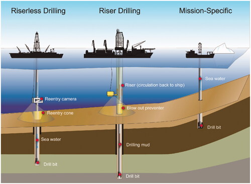
The USA provides the JOIDES Resolution, which takes continuous cores as the IODP’s workhorse (https://JOIDESresolution.org). It uses riserless drilling technology with seawater as the primary drilling fluid pumped down through the drill pipe. The seawater cleans and cools the drill bit and lifts cuttings out of the hole, leaving them in a small pile around the hole. The vessel can drill in water depths of 70–6000 m; most holes are drilled to less than 1000 m below the seafloor. The Resolution has no blowout preventer, but a Safety Committee ensures that numerous techniques are used so that drilling does not encounter over-pressured hydrocarbons and is safe. When drilling sediments and relatively soft sedimentary rock, the JOIDES Resolution can recover 5000 m or more of core during a 2-month expedition. When drilling hard igneous or metamorphic rocks, then that figure is greatly reduced.
Japan provides the larger and much more complex Chikyu (Earth) to drill deeper than the JOIDES Resolution, often in areas where over-pressured oil/gas and water, or high stress, might be encountered. It takes continuous cores only in selected intervals. The Chikyu has a marine riser system to maintain the pressure balance within the borehole, which includes an outer casing that surrounds the drill pipe to provide return-circulation of dense drilling fluid. A cemented-in blowout preventer on the seafloor protects the ship and the environment from the unwanted escape of high-pressure fluids. This technology, involving continuous installation of casing, is necessary for drilling several thousands of metres deep.
Europe provides alternative platforms for areas and programs that are not suitable for the other two vessels, and normally takes continuous cores. Targeted areas include the Arctic and Antarctic where icebergs and floating ice require specialist vessels, and shallow-water regions (e.g. among coral reefs). Depending on the task at hand, such drilling has used a fleet of icebreakers including an ice-breaking drill ship, a relatively small commercial vessel with a wireline rig, a jackup rig, or a conventional oceanographic vessel and a sea-bed drill.
Core processing and storage facilities
Of the three potential platform providers, the JOIDES Resolution does most work in the Australasian region as defined by , and it has impressive laboratory equipment and processing facilities. The drilling crew, technicians, and scientists keep cores flowing, and equipment is busy for 24 h per day. The equipment and facilities are similarly comprehensive aboard the Chikyu. In fact, the Chikyu has also been used in harbour for study and analysis of cores recovered by on-land drilling, such as those of the International Continental Scientific Drilling Program’s exploration of the Oman Ophiolite. The alternative platforms are generally much smaller, so less work can be completed aboard ship and most of the basic core assessment is achieved at post-expedition meetings onshore.
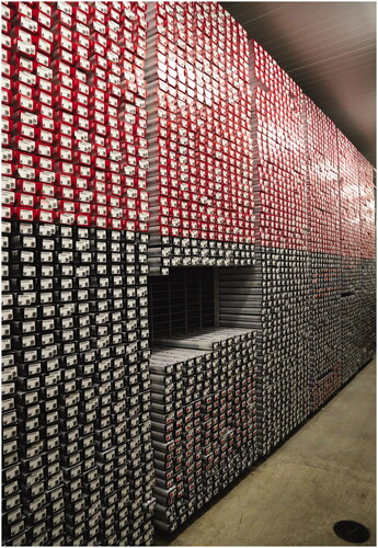
All cores (DSDP, ODP and IODP) are kept wrapped in plastic film in plastic U-tubes at 4 °C in three well-staffed major repositories in the USA (Texas A&M University in College Station), Germany (University of Bremen), and Japan (Kochi University) (http://www.iodp.org/resources/core-repositories). Most cores from the Australasian region are stored in Japan. A total of about 400 km of drill core, the result of 50 years of ocean drilling, are stored in these repositories, along with biological samples stored in a freezer at −20°C or in liquid nitrogen (–196°C). Members of the science party for each expedition have sole access to material during a one-year moratorium period after they obtain their samples. Once the moratorium is over, access to core and other relevant material may be provided to any bona fide scientist based on submitted research proposals. shows the inside of a typical storage facility.
Figure 8. Inside a typical core repository, this example is at College Station, Texas A&M University.
Scientists from around the world can either visit a repository to examine and/or select material, or order material online, on the basis of online reports and images. A curatorial advisory board makes final decisions regarding the distribution of all samples, including requests to image or (rarely) sample the archival halves of cores, based on scientific proposals. The results of all sampling studies must be published and data analyses provided to the repositories. The repositories strongly contribute to the exchange and transfer of marine science knowledge, leading to much international cooperation and scientific interaction.
The Bremen repository stores cores from the Atlantic Ocean, the Mediterranean and Black seas, and the Arctic Ocean. The College Station repository stores cores from most of the Pacific Ocean, the Caribbean Sea and Gulf of Mexico, and the Southern Ocean including the Antarctic margin. The Kochi repository stores cores from the Indian Ocean and the western Pacific Ocean. All three have X-ray fluorescence core scanners (https://sites.google.com/scientific-ocean-drilling.org/xrf-iodp/home).
Introduction to expeditions in the Australasian region
This section provides an overview of scientific ocean drilling in the Australasian region. A more detailed account is provided in Regional expedition results. A regional map (Regional expedition results) shows all the drilling in the region referred to the regional bathymetry. The symbols separate out the DSDP, ODP and IODP programs, and the numbers refer to the various expeditions. It is apparent that there has been a great amount of drilling in the region, to our national and international scientific benefit. Other maps in Regional expedition results show the same base map with sites explored by the respective programs. Larger scale maps show subsets and extensions of the same Australasian region with geographical and structural names added. In Regional expedition results, we identify the site locations and primary targets conducted in our region for the various expeditions of the various phases of ocean drilling. We also list the Australian and New Zealand participants and any co-chief scientists on the expeditions. In later sections, we summarise the results of these expeditions with a thematic approach, citing the available reviews. Supplemental data list all the expeditions outside the Australasian region on which there were Australian and New Zealand scientists. All structural/geographical names used in this text are numbered with locations in the Appendix and are shown in the maps and tables.
How it all began: the DSDP
The passage of time means the least well-known expeditions in our region are those of the DSDP, and accordingly considerable emphasis is given to them in this section, with a brief outline of each of the expeditions included. These expeditions covered huge areas, each with a variety of geological settings. The early exploratory, first-order discovery phase set the scene for problem-solving expeditions of the second phase (IPOD), starting in 1975. The first and final IPOD expedition in our region was Leg 90 in the Southwest Pacific in 1982–83. The DSDP initial reports are available at http://deepseadrilling.org/i_reports.htm. For each leg, an introduction outlines the aims of the expedition, includes the locations of the drill sites, and synthesises the results.
shows the 12 scientific expeditions in the Australasian region in the two phases of activity (see ). It is worth noting that two general operational difficulties constrained the early DSDP drilling. The first of these was the requirement of a sufficient thickness of sediment (>100 m) into which a hole could be spudded. As a consequence, young volcanic rocks exposed at the seafloor could not be recovered. The second was the common occurrence of chert in the sedimentary sequences, especially of middle Eocene age; this lithology proved hard to penetrate with the first generation of rotary core drill bits.
Figure 9. Overview map showing DSDP expeditions and site numbers. Courtesy of Ron Hackney.
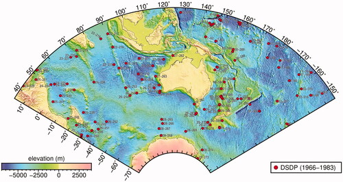
Table 2. DSDP expeditions in the Australasian region.
For the Australasian region, we have had to draw on some grey literature contained in the 1975 Challenger Centenary report of a meeting at Macquarie University led by John Veevers, entitled Deep Sea Drilling in Australasian waters. The first expedition in our region with an Australian scientist on board was Leg 21 in 1971 (Gordon Packham of Sydney University). Subsequently, four Australians served as co-chief scientists on legs in our region: Christopher von der Borch (Leg 22), John Veevers (Leg 27), Lawrence Frakes (Leg 28) and Gordon Packham (Leg 30). Fifteen Australians and 10 New Zealanders took part in the eight expeditions in which we participated. The generosity of the Americans in extending so many scientific positions to Australians and New Zealanders with local expertise is to be applauded, especially as there was an average of only a dozen total scientific positions available on individual legs.
First-order information was obtained by the DSDP for the volcanic ridges and intervening sedimentary basins that characterise the seafloor in our region, and consequently about its plate-tectonic history. For example, DSDP results together with other data were critical in unravelling the history of breakup and drift of the Gondwanan continents, starting about 160 million years ago, and with Australia commencing its separation northwards from Antarctica in the last 90 million years. Summary information for the relevant expeditions is set out below:
Leg 6 (1969): Hawaii to Guam (Sites 55–60 within the Australasian region). This expedition tested the hypothesis that the Pacific crust should age westwards from the East Pacific Rise (Heezen & Fisher, Citation1971). At sites outside our region, the expedition broadly confirmed this and discovered the oldest (Jurassic) oceanic crust in the western Pacific, outboard of the Mariana Trench. West of the Mariana Arc among the ridges and basins of the Philippine Sea, Leg 6 discovered the basement of the Parece Vela Basin is Oligocene in age at Sites 53 and 54 (locations of these sites extend beyond the range of the DSDP map of ). Based on this and other lines of evidence, Karig (Citation1970, Citation1971) made the seminal observation that the so-called “active marginal basins” or “inter-arc basins” of the western Pacific are zones of crustal accretion, possibly generated by seafloor spreading, and not trapped ocean crust; these regions are now termed backarc basins.
Leg 7 (1969): Guam to Hawaii (Sites 61–65 within the Australasian region). Basins, ridges and rises (e.g. the Ontong Java Plateau—OJP), largely along the Equator. Frequently the drilling gave the first information about basin age, sediment fill and basement type. The Mariana and Central Pacific Basins have extrusive basalt beneath Upper Cretaceous and Cenozoic radiolarian clays and cherts; the shallower Caroline Basin to Ontong Java Plateau region has uniform calcareous oozes from the Oligocene (Upper Eocene at Site 64) to the Neogene. The volcanic basement of the OJP was not reached on this leg.
Leg 16 (1971): central equatorial Pacific (Site 163 within the Australasian region). Site 163 successfully recovered sediments older than the middle Eocene and penetrated an Upper Cretaceous-aged basaltic basement.
Leg 21 (1971): Southwest Pacific back-arc basins and Lord Howe Rise (Sites 203–210). In most cases, drilling provided the first information about basin age, sediment fill and basement type. Important scientific results included ages of the Lau (Site 203) and South Fiji (Site 205) basins (late Miocene and older than late Middle Oligocene, respectively), regional plate tectonics, paleo-ocean circulation changes, and Oligocene deep-sea erosion (Kennett et al., Citation1972). Another aspect of the science was the dating of the rhyolites drilled on the Lord Howe Rise (Upper Cretaceous) and the implications for the broader evolution of the Southwest Pacific (McDougall & van der Lingen, Citation1974).
Leg 22 (1972): Wharton Basin and Ninetyeast Ridge (Sites 211–218). The Indian Ocean has a complex history, with separation of Gondwana into plates that include the continents of Africa, Madagascar, Antarctica, India and Australia. The primary aims of this first Indian Ocean expedition were to reveal tectonics associated with the development of the Ninetyeast Ridge, seafloor spreading histories in the Wharton and Central Indian basins, and the development of the Bengal Fan. Knowledge of the Ninetyeast Ridge is critical for reconstructions of the separation of India–Antarctica–Australia. This expedition proved that the ridge was always attached to India and subaerial in places (Pimm et al., Citation1974). The Wharton Basin is no older than Cretaceous and it contains major Paleogene hiatuses (Pimm & Sclater, Citation1974). (Christopher von der Borch was the first Australian co-chief scientist.)
Leg 26 (1972): Indian Ocean (Sites 253–258 were in the Australasian region). This expedition explored the initial breakup of Gondwana, the sedimentation history after the establishment of the Antarctic Circumpolar Current (ACC), the history of spreading along the southwest branch of the Indian Ocean Ridge, the nature and history of the southern part of the Ninetyeast Ridge, and the geological histories of Broken Ridge–Naturaliste Plateau and the southern Wharton Basin. The Ninetyeast Ridge is Eocene in the south; Broken Ridge has a Santonian (ca 84 Ma) carbonate platform; the Naturaliste Plateau has pre-Albian (>113 Ma) glauconitic sand; and the southeast Wharton Basin has Albian (113–100.5 Ma) sediments above oceanic basement. A major paper covered the unconformities in the entire Indian Ocean (Davies et al., Citation1975).
Leg 27 (1972): Abyssal plains of the eastern Indian Ocean (Sites 259–263). The drilling typically gave the first information about basin age, sediment fill and basement type. Basaltic basement ages are Cretaceous in the Perth, Cuvier and Gascoyne oceanic basins (Heirtzler et al., Citation1973). Deep-sea oozes and clays dominate these three and the Argo oceanic basin. Mixed Plio-Pleistocene sediments in the Timor Trough generate much biogenic methane. (John Veevers was co-chief scientist.)
Leg 28 (1973): Southern Ocean, Kerguelen Plateau and Antarctic margin (Sites 264–274). This was the first high-latitude (>66.5°) leg of the DSDP. The Antarctic margin results showed that extensive glaciation started in the Oligocene and that there was a big change in glacial history 4–5 million years ago. Overlying sediment ages indicate that basaltic basement formed at the Southeast Indian Ridge when predicted by seafloor spreading anomalies. (Lawrence Frakes was co-chief scientist.)
Leg 29 (1973): Campbell Plateau, Tasman Sea and Tasmanian region (Sites 275–284). The general sedimentary pattern over time is from initial terrigenous sediments and clay (starting in the Late Cretaceous) to deep-water siliceous ooze and then calcareous ooze. A major theme was Cenozoic paleoceanography. The completely new evidence for the Late Eocene to early Oligocene development of the ACC and continental Antarctic glaciation was of global significance (e.g. Kennett et al., Citation1974). The ACC was initiated through separation of the South Tasman Rise from Antarctica; by the late Oligocene, the easterly flowing ACC was fully established, forming a worldwide, deep ocean unconformity. This fundamental change in the world’s oceanic circulation and its climate marks the onset of the modern climatic regime.
Leg 30 (1973): Southwest and western Pacific basins (Sites 285–289). A new tectonic history of the Southwest Pacific arc and marginal sea complex was developed using the results of this and earlier DSDP expeditions. The basaltic basement forming the Ontong Java Plateau was reached at Site 289. Although a number of hiatuses were observed, carbonate-rich, Cretaceous-aged sedimentary sequences were recovered at Sites 288 and 289. Important results were published by Klein (Citation1975). (Gordon Packham was co-chief scientist.)
Leg 33 (1973): Western Pacific east of the international date line, from near Hawaii in the north to Manihiki Plateau in the south (Sites 314–318). The main aim was to document the genesis and age of several linear island chains, both by drilling the chains themselves and by drilling the deep-sea fans derived from them. Most volcanic edifices proved to be Cretaceous in age.
Leg 90 (1982–3): A longitudinal Cenozoic (largely Neogene) paleoceanographic transect in flat-lying strata in deep water, mostly in the Tasman Sea. Sites were: Ontong Java Plateau (Site 586), Lord Howe Rise (Sites 587–593), and Chatham Rise (Site 594). Site 586 had a continuous, uncomplicated section of Quaternary to early late Miocene age. The Lord Howe Rise sites (dominantly carbonates) concentrated on the Neogene but some penetrated Paleogene and Upper Cretaceous strata. They showed a complex history: subsidence and deposition of shallow marine and pelagic sediments in the Paleogene; uplift in the Eocene, in some cases to above wave base; and subsidence thereafter with deposition of pelagic carbonates. A major Oligocene unconformity was normally present. The Chatham Rise site extended into the Miocene and monitored the changing influences of terrigenous and pelagic sequences. The first hemipelagic sequences occurred about 6 million years ago, replacing the older completely calcareous pelagic facies. This dated the beginning of the Kaikoura Orogeny, when the New Zealand (southern) Alps were uplifted along the Alpine Fault. This was the very successful first expedition to deliberately document latitudinal changes in water properties and sediment ages and types over time.
Next phase: ODP
The ODP aimed to solve established global scientific problems, in many cases based on the DSDP’s curiosity-driven exploration, and focussed attention on areas of smaller extent thereby also minimising long transits. The key website for ODP data is http://www-odp.tamu.edu/publications. Individual expeditions can generally be accessed on the web using the format doi:10.2973/odp.proc.ir.119.
Much of the Australian story is outlined in the ODP review by Baker and Keene (Citation2004). shows the 26 ODP expeditions in the Australasian region as listed in . Australia joined the ODP in 1988 and was involved in expeditions until ODP’s conclusion in 2003. Prior to joining ODP, Australian and New Zealand scientists had helped write proposals for work in the Australasian region and took part in expeditions. Five expeditions (Legs 119–123) took place before Australia became a member; eight Australians took part in these expeditions based on their expertise, and one (Neville Exon) was a lead proponent of the drilling proposal that led to legs 122 and 123 on the Northwest Australian margin.
Figure 10. Overview map showing ODP expeditions and site numbers. Courtesy of Ron Hackney.
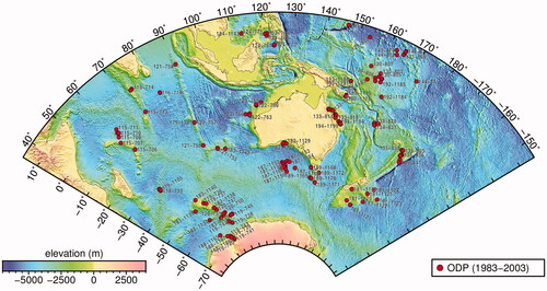
Table 3. ODP scientific expeditions in the Australasian region.
After Australia joined ODP there were seven Australian co-chief scientists, all of whom had been lead proponents for their expeditions: Peter Davies (Leg 133), Robert Carter (Leg 181), David Feary (Leg 182), Philip O’Brien (Leg 188), Neville Exon (Leg 189), Raymond Binns (Leg 193) and Alexandra Isern (Leg 194). Altogether 40 Australians joined regional expeditions and a further 30 Australians took part in expeditions outside our region. Three New Zealanders joined Leg 181. Although New Zealand was not an ODP member, three New Zealanders (Lionel Carter, Bruce Hayward and Gary Wilson) took part in Leg 181, which was in New Zealand waters. Australia and Canada formed an ODP consortium, and later Korea and Taiwan joined them to form the “PacRim consortium”. In order of Australian funding commitment, the Bureau of Mineral Resources (Australian Geological Survey Organisation after 1992, and Geoscience Australia after 2001), the Australian Research Council, 20 Australian universities and the CSIRO were involved. Over the years the Australian ODP office was hosted in sequence, spread over the years from 1988 to 2003 inclusive, by the University of Tasmania (Anthony Crawford, Director), the University of New England (Richard Arculus, Director), James Cook University (Robert Carter, Director) and the University of Sydney (Jock Keene, Director).
Almost all the highly ranked scientific targets then identified in the region were drilled by these expeditions, some targeted more than once, and the accumulated knowledge has proven to be of fundamental and enduring worth.
Present phase: IODP expeditions
IODP’s aim was to continue to solve global scientific problems, focussing its attention on constrained areas. ANZIC joined IODP1 in 2008 as an associate member. Details of ANZIC activities, especially until 2013, are provided in Exon (Citation2017). The program office was at the Australian National University, with Neville Exon serving as the Program Scientist until late 2017, and Leanne Armand thereafter. The bulk of the funding came from the Australian Research Council, but substantial funding also came from our Australian partners (14 universities and two government agencies in 2020), with a valuable further contribution from New Zealand (two government agencies and three universities in 2020). Richard Arculus was the Chief Investigator and Lead Scientist for the ARC grant from 2008 until the end of 2020, followed by Eelco Rohling until 2022. The number of ANZIC-supported shipboard scientists and shorebased researchers increased substantially during IODP1 and especially in the current phase of IODP2.
The Program Scientist worked closely with the ANZIC Governing Council, which comprises inter alia scientists representing the funding partners and the Science Committee, selected because of their areas of expertise. The Chairs of the Governing Council over the years—Kate Wilson (2008–2010, initially CSIRO), Geoffrey Garrett (2011–2016, former CSIRO Chief), and Ian Poiner (2017–2021, former Director of the Australian Institute of Marine Sciences)—provided very valuable organisational and strategic planning input. The Chairs of the Science Committee—William Howard (2008, then University of Tasmania), Stephen Gallagher (2009–2014, University of Melbourne), Robert McKay (2015–2017, Victoria University of Wellington), Millard (Mike) Coffin (2018–2019, University of Tasmania) and Joanna Parr (2020, CSIRO)—helped steer the ANZIC science program and nominate shipboard scientists after competitive review.
shows the 21 IODP expeditions in the Australasian region as listed in . There were three Australian and six New Zealand co-chief scientists, all of whom had been lead proponents for their expeditions: Jody Webster (Expedition 325), Richard Arculus (Expedition 351), Stephen Gallagher (Expedition 356), Rupert Sutherland (Expedition 371), Ingo Pecher and Philip Barnes (Expedition 372), Robert McKay (Expedition 374), Laura Wallace (Expedition 375) and Cornel de Ronde (Expedition 376). In all, 32 Australian scientists and one outreach and education officer, and 22 New Zealand scientists and three outreach and education officers, took part. Many scientists, especially New Zealanders, were generously added to our formal ANZIC quotas. Note that the activities of Australian and New Zealand participants, who sailed for expeditions outside this region, are not covered in this paper, but the expeditions are listed in the Supplemental data.
Figure 11. Overview map showing IODP expeditions and site numbers. Courtesy of Ron Hackney.
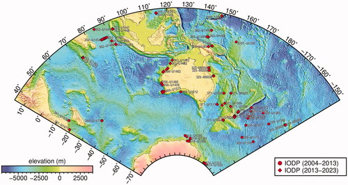
Table 4. IODP Expeditions in or the Australasian region. All expeditions used JOIDES Resolution except ECORD Expedition 325.
ANZIC scientists were major drivers of many of the proposals and the number of successful proposals is a huge credit to them. ANZIC can certainly claim that the scientific interest and high quality of the proposals led to the scheduling of many more regional expeditions than would have been expected purely through ANZIC’s financial input. This clearly indicates that the scientific merit of proposals is the driver of successful proposals. Of course, once a scientific drilling vessel is in the Australasian region, additional excellent proposals have a high chance of success. On this basis ANZIC took the lead in setting up highly successful planning workshops, to increase the number of excellent proposals in the Indian Ocean (2011) and the Southwest Pacific Ocean (2012). For each expedition, the scientific prospectus, preliminary report, proceedings, and publications stemming from the expedition, are available at http://publications.iodp.org/index.html.
Regional expedition results
In this section, our aim is to guide a reader interested in particular regions or features to the relevant literature. We outline the geological context and some key discoveries of scientific ocean drilling expeditions within the domains of the Australasian region. We group the latter by their morphological and geological origins; and the map of provides the link between the features (coded in the ) and the expeditions. are more detailed maps covering four areas that make up the Australasian region. is another detailed map showing the Izu–Bonin–Mariana region. These figures also display the structural features identified in and listed in the tables and Appendix.
Figure 12. Overview map showing ocean drilling sites, and geographical and structural names. The latter are numbered on the map generally from west to east, within Indian Ocean, Southern Ocean and Pacific Ocean. All information listed in numerical order in the Appendix, including approximate latitudes and longitudes.
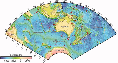
Figure 13. Regional map of northwestern area showing numbered locations of geographical and structural features listed in the Appendix and relevant tables.
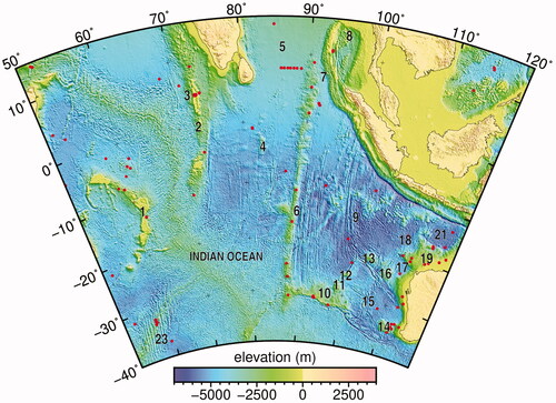
Figure 14. Regional map of southern area showing numbered locations of geographical and structural features listed in the Appendix and relevant tables.
Figure 15. Regional map of eastern area showing numbered locations of geographical and structural features listed in the Appendix and relevant tables.
Figure 16. Regional map of northern area showing numbered locations of geographical and structural features listed in the Appendix and relevant tables.
Figure 17. Regional map of Izu–Bonin–Mariana area which puts the three IODP expeditions into their geographical and structural context.
Indubitably, the sum of scientific ocean drilling has drastically improved our understanding of the geologic, ocean and climate histories of the region. This effort complements numerous marine geological and geophysical expeditions, petroleum exploration industry drilling of continental margins, satellite mapping, and improvements in technology that have also dramatically increased our scientific knowledge and understanding. Recovery of extended sections of sediments, both in the deep sea but also on margins of continents and fragments thereof, is critical for determining the history of the oceans and positions of continents (e.g. Dutkiewicz et al., Citation2016). In Some major achievements of regional ocean drilling, we will outline some major achievements of the research.
Developments over time will be illustrated using examples from scientific ocean drilling expeditions from 1973 to 2018. This drilling built up an ever-improving understanding of the region’s geological history, which started with an almost blank sheet. Although some individual expeditions covered various areas and environments, we have grouped the results below, with all expeditions in a particular region covered together. We have emphasised some expeditions more than others.
An up-to-date publications list for any IODP expedition can be found under the heading “Bibliographic Records Organized by Expedition” at http://iodp.tamu.edu/publications/bibliographic_information.html. There is also a link at the bottom of this site for ODP expeditions. The ODP lists are no longer being updated, so they may not have the most current publications. The reader can also find citations related to DSDP, ODP and IODP expeditions through the Scientific Ocean Drilling Bibliographic Database at http://iodp.americangeosciences.org/vufind/. The reader may use the single search window on the home page or click on the “Advanced” button to get an expanded search page where search terms for multiple categories (e.g. title, author, research program, publication year, key words) are displayed. Search tips are available on the Advanced Search page.
Context
The oldest oceanic crust in the Indo-Pacific region generated by seafloor spreading is of Middle Jurassic age (Bathonian; 168 Ma), outboard of the present Mariana Arc (Koppers et al., Citation2003). This comprises the oldest crust of the Pacific Plate, originally generated at a triple junction between the Izanagi, Farallon and Phoenix plates (e.g. Seton et al., Citation2012). All older oceanic crust in this region has been recycled into the Earth’s mantle. Sedimentary rock sequences older than the Jurassic have been recovered by ocean drilling of the continental shelves and offshore plateaus. The history of the births and deaths of the many lithospheric plates that have appeared through Earth’s history, and the creation and demise of their respective boundaries, is of fundamental importance to the development of the surface and interior of this planet. In the Australasian region, although it represents only a fraction (∼28%) of the Earth’s surface, a complex and representative history of plate creation, relative motions, boundary interactions, supercontinent fragmentation, and latitudinal and meridional ranges of ocean–atmosphere–biosphere interactions from the Mesozoic through to the present is accessible by ocean drilling.
The continents and surrounding oceanic portions of the respective plates of the Australasian region displayed in are mostly the dispersed fragments of Eastern Gondwana. There is a burgeoning literature describing, analysing, and modelling the kinematics and dynamics of the processes leading to this dispersal, and creation of intervening seas and oceans. In the following, we use inter alia, dates and specifics of a number of recent publications, especially that of Müller et al. (Citation2019), which incorporates deformation along plate boundaries.
We now summarise the critical events that have occurred around the margin of the continental mass of Australia, moving anti-clockwise from the western margin. The development of the oceanic crust between Australia and Antarctica, to a first approximation, has the simplest history of all the tectonic domains surrounding Australia. These were the last of the major continental fragments to separate (Gibbons et al., Citation2013), commencing with stretching and thinning of connective crust at ca 160 Ma, to slow movement (directed northwest–southeast) at ca 90 Ma and faster (north–south) at ca 50 Ma as seafloor spreading developed (Williams et al., Citation2019).
The eastern margin of Eastern Gondwana has been more complex, dominated since the Paleozoic by subduction zones of varying polarity, back-arc basins, rifting events resulting in ribbons of continental crust outboard of the margin, including Zealandia (Mortimer et al., Citation2017, Citation2019), ridge creations and jumps, and transform fault developments. From ca 400 to 130 Ma, the Phoenix Plate was subducting along the eastern margin of Gondwana (Matthews et al., Citation2016; Müller et al., Citation2016), followed by the Pacific and then Hikurangi plates (Wright et al., Citation2016). Subsequently, a number of smaller, dominantly oceanic plates have developed and been partly subducted along this margin. Subduction accompanied the commencement of spreading between Australia and Zealandia at ca 90 Ma, that included the component continental fragments of the latter, such as the Lord Howe and Chatham rises, Challenger and Campbell plateaus, and New Zealand (e.g. Jordan et al., Citation2020; Nelson & Cottle, Citation2018). By 70 Ma, the Tasman Sea ridge connected through to ridges between Antarctica and the Pacific, and from ca 62 to 52 Ma, Zealandia was on a separate plate from that including Australia and Antarctica, consequent to the propagation of spreading from the Tasman to Coral seas, and linkage with microplate boundaries in the southwestern Pacific. At ca 50 Ma, the Tasman Sea ridge ceased spreading, resulting in the recombination of Zealandia and Australia in the same plate. By 35 Ma, the Pacific–Antarctic Ridge connected through to the Australia–Antarctic ridge, thereby completing the isolation of Antarctica and fragmentation of the major continents that formed Gondwana. From ca 80 Ma to the present, the Pacific Plate has subducted along the eastern margin of the Australian and bordering plates. A complex series of arc and reararc development has occurred with the formation of troughs (e.g. New Caledonia), back-arcs (Lau-Havre Trough, South and North Fiji basins) and continental ribbons (Crawford et al., Citation2003; Schellart & Spakman, Citation2012). A subduction polarity reversal developed consequent to the arrival at ca 8 Ma of the Ontong Java Plateau at the Vitiaz Trench, outboard of the Solomons and New Hebrides arcs (Petterson et al., 1999). A subduction zone is in an early stage of development south of New Zealand along the Puysegur Trench (Gurnis et al., Citation2019).
Complexities in terms of plate-tectonic evolution around the northern and western margins of Australia are also manifold, primarily as a result of a prolonged history of fragmentation of Gondwana (e.g. Gibbons et al., Citation2013; Metcalfe, Citation2006; Müller et al., Citation2019). In terms of our focus in this paper, we can summarise the important events from the late Paleozoic onwards, commencing with the rifting away of the Cimmerian terranes that later accreted to Eurasia (Şengör, Citation1979), development of passive margins on the conjoined northern Africa, Eurasia, India and Australia, and formation of the MesoTethys ocean between Gondwana and the Cimmerian terranes at ca 260 Ma (cf. Müller et al., Citation2019; Stampfli & Borel, Citation2002). At ca 175 Ma, stretching commenced between West (Africa and South America) and East Gondwana (India, Antarctica and Australia), and developed into spreading between Africa and India and stretching between India, Australia and Antarctica at ca 160 Ma. Spreading between India–Madagascar and Africa extended around the northern margin of India and Australia between 155 and 140 Ma, along the southern margin of what became the NeoTethys. From ca 130 to 125 Ma, spreading also commenced between India and Australia–Antarctica, propagating northeastwards to form a triple junction with the ridge in the southern NeoTethys. India had become isolated at this time from Australia and Antarctica.
At ca 80 Ma, a ridge jump from west to east of Madagascar occurred, with spreading developed between Madagascar and India. By the same time, spreading had commenced and propagated eastwards between Australia and Antarctica, continuing as the present-day Southeast Indian Ridge, linking with the Pacific–Antarctic Ridge at ca 35 Ma. At ca 43 Ma, spreading between Australia and India ceased, possibly coincident with the hard docking of India with Asia. Australia, Antarctica and India had temporarily become part of the same plate again, but at 35 Ma, the former two separated, and beginning at ca 20 Ma a new plate boundary developed between Australia and India, forming the intervening Capricorn Plate (Royer & Gordon, Citation1997). The fragmentation of Eastern Gondwana was mostly complete by this time.
While plate tectonics represents the dominant process creating and modifying the Earth’s surface topography (modified also by erosion and deposition), mantle plumes are a style of mantle convection that is prominent in surface expression as oceanic plateaus (and subaerial volcanic buildups when on continental crust) and chains of islands, atolls and seamounts (Wilson, Citation1963). Numerous examples of these are developed in the Australasian region. Initial magma production upon arrival of a decompressing and expanding plume head at the Earth’s surface can be sufficient to create basaltic crustal thicknesses, over a few million years, equivalent to the average continental crust (∼35 km, e.g. Hill et al., Citation1992), as was the case with the Ontong Java Nui plateau (Chandler et al., Citation2015). These massive effusions are also known as large igneous provinces (LIPs). The Ontong Java Nui plateau has disaggregated into the Ontong Java, Manihiki, and Hikurangi plateaus (Taylor, Citation2006). Arrival of oceanic plateaus at subduction zones is a primary mechanism leading to reversal in the respective geometry of subducting and overriding plates, e.g. Ontong Java adjacent to the Solomons and New Hebrides arcs, or the partial jamming of the subduction zone, e.g. the Hikurangi Plateau adjacent to the North Island of New Zealand.
Persistent uprising of a plume of hot, relatively low-density mantle may continue to partially melt as it approaches the Earth’s surface; if the tectonic plate in and upon which the generated magmas are emplaced were moving relative to the more-or-less stationary mantle plume, a chain of volcanoes would develop as the plate is translated over the plume locus (Morgan, Citation1972). Note however, the assumption of hotspot fixity has been shown to be invalid in the case of the Hawaii (Tarduno et al., Citation2009) and Indian Ocean hotspots (O’Neill et al., Citation2003), but not for the Louisville chain, at least for a portion of its life (Koppers et al., Citation2012). Mantle tomography has confirmed the presence of low-seismic velocity columns of material, extending upwards from the lower mantle and underlying active volcanic loci such as Réunion, Kerguelen, and Amsterdam in the Indian Ocean (Zhao, Citation2007), and likewise Samoa, Pitcairn and MacDonald in the southern Pacific Ocean (French & Romanowicz, Citation2015). Ridges linked with respective hotspots include the Chagos-Laccadive with Réunion, Eightyeast Ridge with Crozet, Ninetyeast Ridge with Kerguelen, and multiple tracks in the South Pacific Ocean (Finlayson et al., Citation2018; Jackson et al., Citation2010). The Louisville Ridge has no distinct expression at the putative current locus (Koppers et al., Citation2011) but is probably the tail of the original Ontong Java Nui LIP (Chandler et al., Citation2012). There are clear southerly younging age progressions along the East Australian volcanic chain (Davies et al., Citation2015), and the Tasmantid and Lord Howe seamount chains, but no indications at present for deep-seated (low-seismic velocity) mantle plumes underlying any of the respective, nominally active loci (Crossingham et al., Citation2017; Seton et al., Citation2019).
The distribution of mantle plumes is predominantly concentrated over the perimeters of two “large low shearwave velocity provinces” (LLSVP) antipodally and equatorially located at the base of the mantle, centred on Africa and the Pacific (Burke et al., Citation2008; Garnero et al., Citation2007). Temporal variation in the flux of plume-head-related magmas as a crust-forming process has been quantified, with a Mesozoic–Cenozoic peak in the Cretaceous (East et al., Citation2020; Müller et al., Citation2016). Numerous consequences follow from the waxing and waning of this process, ranging from long-term sea-level changes, enhanced volatile fluxes into the ocean/atmosphere system (Neal et al., Citation2019), to environmental effects such as episodes of ocean anoxia (Kerr, Citation2005). The possibility that the breakup of supercontinents is enhanced by the impact of mantle plumes on the continental lithosphere has also been posited by many authors (e.g. Storey, Citation1995) and disputed by others (e.g. Olierook et al., Citation2019). In this context, the overall breakup of Gondwana could have been driven by plumes peripheral to the sub-African LLSVP.
Decades of geochemical study of the basalts erupted at spreading ridges in the major oceans have revealed substantial heterogeneity “on all spatial scales” (Hofmann, Citation2014), and further that the “often-invoked homogeneity of mid-ocean ridge basalts (MORB) and MORB sources is largely a myth”. Within this spectrum of global heterogeneity, it is also clear that MORB in the Indian Ocean are isotopically distinct (inter alia: 87Sr/86Sr, 143Nd/144Nd, 206Pb–207Pb–208Pb/204Pb, 176Hf/177Hf; Dupré & Allègre, Citation1983; Hofmann, Citation1997; Subbarao & Hedge, Citation1973) compared with those of the Pacific Ocean. A boundary between the Indian and Pacific types, for example, is located across a single transform fault of the Southeast Indian Ridge (so-called Australia–Antarctic Discordance; Christie et al., Citation2004). Basalts erupted at hotspots and plateaus extend to even more isotopically distinctive types (Hofmann, Citation1997; White, Citation1985; White & Hofmann, Citation1982). These types were labelled by Zindler and Hart (Citation1986) based on the isotopic ratios listed above, as HIMU (where μ = 238U/204Pb), enriched mantle-1 (EM1) and enriched mantle-2 (EM2). The original term PREMA introduced by those authors for prevalent (possibly lower) mantle has been generally replaced by FOZO for focal zone (Hart et al., Citation1992), and is manifest in a number of LIPs. Collectively, the upper mantle sources of the entire spectrum of MORB are grouped as the “depleted MORB mantle” (DMM). The nature of the various mantle components, their origins, locations, and significance are controversial issues. Examples of extreme isotopic types appear at several ocean islands/hotspot loci: Austral islands ∼ HIMU, Pitcairn ∼ EM1, Society islands and Samoa ∼ EM2. Components of subducted plates and delaminated continental lithosphere that have been stored and isolated for long periods in the mantle are most commonly invoked to account for these isotopic characteristics. Possibilities are subcontinental lithosphere, EM1; continent-derived sediments, EM2; and ancient, altered basaltic oceanic crust/Archean carbonate/carbonatite, HIMU (cf. Castillo, Citation2015; Jackson & Dasgupta, Citation2008; Nebel et al., Citation2013; Stracke et al., Citation2005; Weiss et al., Citation2016).
Indian Ocean
We note that important results of ODP expeditions from 115 to 123 inclusive in the Indian Ocean are summarised by Duncan et al. (Citation1992). The following subsections summarise all relevant expeditions.
Northwest Australian continental margin
The areas of the Australian continental margin addressed here comprise the Northwest Shelf and the Exmouth Plateau; the latter is ∼300 km wide and extends for 800 km northwestward as a deep-water extension of the Northwest Shelf. The shelf is a passive margin formed adjacent to seafloor spreading in the southern MesoTethys. The first phase of breakup, as documented in the Argo Abyssal Plain by DSDP Site 261 and ODP Site 765, commenced in the Late Jurassic, with basement basalts dated as ca 155.3 Ma (Ludden, Citation1992). The second phase of breakup, as documented by magnetic lineations in the Cuvier and Gascoyne abyssal plains, commenced in the Early Cretaceous at ca 135 Ma (Fullerton et al., Citation1989).
The expeditions drilled (summarised in ; see for site locations and for tectonic/geographic features) were Exmouth Plateau (ODP Legs 122 and 123), Northwest Shelf (IODP Expedition 356), and the Western Pacific Warm Pool (IODP Expedition 363).
Table 5. Outline of scientific drilling of the western Australian continental margin.
ODP Leg 122 drilled Upper Triassic, Cretaceous, and Cenozoic rocks. The Cretaceous and Cenozoic carbonate rocks are best revealed on the central Exmouth Plateau (Haq et al., Citation1992) and the more varied Upper Triassic rocks on the Wombat Plateau (von Rad et al., Citation1992), a northern extension of the Exmouth Plateau.
Sites 762 and 763 (1340 and 1367 m water depth; 940 and 1037 mbsf), on the Exmouth Plateau proper, were drilled after the first round of petroleum exploration, very near Eendracht 1 and Vinck 1 wells. Between them, the two sites recovered thick sequences of Lower Cretaceous deltaic sediments, overlain by Upper Cretaceous hemipelagic sediments, succeeded by thick Cenozoic, largely pelagic carbonates. The Lower Cretaceous deltaic sediments host the giant Scarborough gas field; a development decision by Woodside of this field is scheduled for late 2021.
Sites 759, 760, 761 and 764 were on the Wombat Plateau (1970–2697 m water depth, 287–506 mbsf). Sites 761 and 764 penetrated Upper Triassic (Rhaetian: 208–201 Ma) reefal carbonates for the first time in Australia, above fluvio-deltaic Norian (227–207 Ma) sediments. Similar carbonates are large producers of hydrocarbons in Indonesia, so a paper on the petroleum implications of the Wombat Plateau carbonates (Williamson et al., Citation1989) generated considerable industry interest in finding similar carbonates at depth elsewhere on the Exmouth Plateau. Unconformably overlying the Triassic sequences is an expanded Paleocene chalk sequence, overlain by younger pelagic carbonates, containing various discontinuities. The Jurassic–Cretaceous sequence is absent because of several periods of uplift and erosion.
In summary, this expedition provided important information on the southern margin of the MesoTethys, with the first discovery of Upper Triassic reefal rocks in Australia as a major highlight. Other important information from the margin came from the expanded, fully cored stratigraphy of the Cretaceous and Cenozoic sequences as compared with those on the adjacent Northwest Shelf petroleum province.
ODP Leg 123 (Ludden et al., Citation1990) drilled Site 766 at the foot of the continental slope on the western Exmouth Plateau near the interpreted M10 (ca 136 Ma) oceanic magnetic anomaly. It was drilled to 527 mbsf in a water depth of 3997 m, recovering Cenozoic and Lower Cretaceous sediments, with the oldest being Valanginian (ca 137 Ma). The site bottomed in intrusive basalt/diabase sills and dykes, dated with alteration celadonite by Ludden (Citation1992) at 155.3 ± 3.4 Ma (Kimmeridgian–Oxfordian). Buffler et al. (Citation1992), based on the seismic stratigraphy and the nature of the oceanic magnetic anomaly at the site, concluded that the basement is part of a rifted continental crust.
IODP Expedition 356 (Gallagher et al., Citation2017), the Indonesian Throughflow expedition, drilled a longitudinal transect (∼1700 km) from ∼28 to 17°S, largely on the Northwest Shelf, targeting Neogene sediments. The first three sites (U1458–1460) were actually further south on the Gascoyne Shelf in water depths of 157–214 m and drilled up to 400 mbsf. The four sites on the Northwest Shelf itself (U1461–1464) were in water depths of 87–264 m and drilled 530–1095 mbsf.
The expedition successfully addressed three main topics recorded in these sediments relevant to the last 5 million years of the shelf’s history: (1) the fluctuating nature of the major ocean currents, especially the unique (for the eastern margin of a Southern Hemisphere ocean) south-flowing, Leeuwin Current. Fluctuations are controlled by sea-level rise and the variable opening of the Indonesian straits through which warm water flows from the Western Pacific Warm Pool; (2) the onset of the monsoon and regional aridity and their variation over the last 5 million years; and (3) the regional subsidence history that showed the region sinking synchronously ∼250 m at about 5 Ma and then rising again. Gurnis et al. (Citation2020) asserted “the vertical motions are too large to be associated with simple flexure of a plate and plate buckling in that the required amplitudes would lead to permanent deformation of the plate.” These authors further state “a new geodynamic mechanism is required to fit the observations”.
In addition to successfully addressing the main questions of upper Neogene paleoceanography, Site U1469 reached the Eocene sediments, and Sites U1461, 1462 and 1463 all reached the Miocene sediments. The petroleum industry does not take many cores and generally there are no samples from the youngest intervals comprising the top several hundred metres of industry wells. Consequently, the extensive measured velocity information from these continuous IODP cores, located on industry seismic lines, allows better estimates of the velocities associated with different Cenozoic seismic facies. Where seismic facies and velocities are highly variable, companies need this critical information to estimate the size of deeper petroleum reservoirs.
IODP Expedition 363 (Rosenthal et al., Citation2018), to the Western Pacific Warm Pool, drilled two sites (U1482 and U1483) on the upper slope of the Northwest Shelf northeastward of Expedition 356, to investigate the varying position of tropical and subtropical fronts over time in a region of expanded stratigraphy with well-preserved foraminifera. The sites were drilled in water depths of 1466 and 1737 m, to 534 and 290 mbsf. U1482 recovered upper Miocene to Pleistocene nannofossil chalk and ooze, and U1482 recovered lower Pliocene to Recent pelagic to hemipelagic nannofossil ooze. An important observation by Dang et al. (Citation2020) based on benthic foraminifera δ13C and δ18O values is a lengthening of the long-term δ13C cycle observed at ca 1.6 Ma that is related to a deep Pacific circulation change, prolonging the cycling of carbon in the ocean.
Aseismic ridges and plateaus of the Indian Ocean
The nominally aseismic plateaus and non-spreading ridges of the Indian Ocean were created variously as irregular-shaped continental fragments (some with partial cover by hotspot-related basalt flows, volcanic ash layers and sediments), individual volcanic edifices, and seamount chains formed at “hotspots”. Key evidence has emerged over the last two decades that continental crust is present in the basement of many of the plateaus of the southern Indian Ocean. These include the largest, the Kerguelen Plateau, and smaller fragments such as the Naturaliste Plateau, and Broken Ridge. Evidence of continental basement is reported for Wallaby and Zenith plateaus (Gibbons et al., 2012), Gulden Draak Rise (Gardner et al., 2015), and Batavia Knoll (Halpin et al., 2017) but even the smallest plateaus not yet explored by scientific drilling have been found to have various proportions of continental crust. These include Wallaby and Zenith plateaus (Gibbons et al., Citation2012), Gulden Draak Rise (Gardner et al., Citation2015), and Batavia Knoll (Halpin et al., Citation2017). According to Whittaker et al. (Citation2016), a combination of “plate reorganisation and plume-driven thermal weakening” was required to “calve” some of these microcontinents from Eastern Gondwana.
There have been nine regional expeditions involving Indian Ocean ridges and plateaus, with three being carried out by DSDP, seven by ODP and three by IODP (; ). The features drilled were the Laccadives–Maldives Ridge (IODP Expedition 359); Ninetyeast Ridge (DSDP Leg 22, ODP Leg 121 and IODP 353 Site U1443); Broken Ridge (DSDP Leg 26, and ODP Legs 121 and 183); Naturaliste Plateau (DSDP Legs 26 and 28, and IODP Expedition 369); and Kerguelen Plateau (ODP Legs 119, 120 and 183).
Table 6. Outline of scientific drilling of Indian Ocean ridges and plateaus.
Laccadives–Maldives Ridge
The linear north–south Laccadives–Maldives Ridge is more than 2500 km long and averages 250 km wide. The ridge formed as the Indian plate moved northward in the Cenozoic and appears to be largely volcanic.
IODP Expedition 359 (Betzler et al., Citation2018) was carried out in 2015 to explore the history of the carbonate banks of the Maldives, changes in sea level and currents of the Indian Ocean, and the initiation and evolution of the Asian monsoon. The core recovery was outstanding for some sites, at well over 90%, and has enabled a detailed record to be determined of the extrinsic controlling factors for carbonate platform growth through time (Betzler et al., Citation2018). For example, aggradational platform growth and long-term sea-level stands were documented during the early to middle Miocene, encompassing the Miocene Climate Optimum dated between 17 and 15.1 Ma. Lowering of sea level in the middle Miocene is coincident with eastern Antarctic ice sheet expansion. Between 13 and 12.9 Ma, an abrupt change in sedimentation pattern with drift deposition reflects the onset of monsoon-wind-driven circulation in the Indian Ocean, and establishment of modern ocean circulation patterns (Betzler & Eberli, Citation2019; Reolid et al., Citation2019). Records from other tropical carbonate platforms previously explored by the ODP (e.g. Bahamas and Marion Plateau) yield similar histories of sedimentation patterns driven by sea-level changes (early to middle Miocene) replaced by younger, current-driven controls.
Ninetyeast Ridge
The north–south-striking Ninetyeast Ridge is a linear bathymetric feature, 5600 km long. The width of the ridge is 200 km on average. The topography includes flat-topped, low- to high-relief seamounts, and linear segments. It originated primarily as a trail generated at the Kerguelen hotspot but, in detail, the evolution of the ridge is complex. It was drilled during DSDP Legs 22 and 26, ODP Leg 121, and IODP Expedition 353. The southern end, dated at 43 Ma (DSDP Site 254) intersects Broken Ridge; the northern end is buried under the Bengal Fan, but basaltic basement at ODP Site 758 is dated at 83–81 Ma by Duncan (Citation1991) and 77 Ma by Krishna et al. (Citation2012). The Ninetyeast Ridge is the product of hotspot activity atop a spreading ridge (Wharton)-transform complex that separated the Indian and Antarctica–Australia plates, but also experienced a number of spreading centre jumps (Krishna et al., Citation2012; Müller et al., Citation2016). The ridge was separated from the Kerguelen Plateau by seafloor spreading of the Southeast Indian Ridge.
DSDP Leg 22 took place in 1972, when the tectonic history of the region was obscure. This expedition (von der Borch & Sclater, Citation1974) spot-cored at five sites (213–217) on and near the ridge. Those on the ridge (214, 216 and 217 from south to north) were in water depths of 1665, 2247 and 3030 m and drilled 490 to 667 mbsf.
Site 214 drilled 490 m of sediment and 4 m into basalt basement. Above basement are lignitic and volcanoclastic sediments and tuffs interbedded with differentiated igneous flows. The basement basalt was dated using K/Ar (58 Ma) and Ar/Ar (58.5 Ma) by Duncan (Citation1978) and also, using K/Ar (53.4 Ma) by McDougall (Citation1974); it is overlain by Paleocene (ca 57 Ma) to Eocene glauconitic carbonate silt. Above this sequence is thick lower Eocene to upper Pleistocene carbonate ooze. The sequence indicates subsidence from at or above sea level in the Paleocene to its present depth of 1665 m.
Site 216, 1300 km north of Site 214, drilled 457 m into a similar sequence, and 20 m into slightly altered basalt basement, dated using K/Ar (52.5 Ma) and Ar/Ar (81 Ma) by Duncan (Citation1978), but analytical difficulties render both dates as uncertain. McDougall (Citation1974) had earlier obtained a K/Ar date of 64.1 Ma. This basement is overlain by upper Maastrichtian (ca 66 Ma) shallow-water chalk, volcanic clay, and ash. Above the basalt is upper Maastrichtian to Pleistocene nannofossil ooze to chalk unit, glauconitic at the base. The sequence indicates subsidence from at or above sea level in the Maastrichtian to its present depth of 2247 m.
The northernmost Site 217 drilled 667 m and bottomed in an upper Campanian (ca 72 Ma) interbedded sequence including dolomitic sandstone and silicified chalk. This is overlain by thick upper Campanian to upper Miocene shallow marine nannofossil ooze and chalk, capped by upper Miocene and younger clay-rich nannofossil ooze. The sequence indicates subsidence from shallow depths in the Maastrichtian to its present depth of 3030 m.
Von der Borch and Sclater (Citation1974) noted key (and enduring) results such as the relative youth of the Wharton Basin (no older than Cretaceous), the discovery of non-marine lignite at Site 214, and very shallow environments for basal sediments at all three sites. The three sites aged northward from the Paleocene (ca 57 Ma) to late Campanian (ca 72 Ma), and correspondingly subsided to their present depths of 1665–3030 m from near sea level. The age progression is incorporated in and consistent with the models of Krishna et al. (Citation2012) and Müller et al. (Citation2016).
DSDP Leg 26 (Luyendyk & Davies, Citation1974) drilled Sites 253 and 254 on the southernmost Ninetyeast Ridge. They confirmed this portion of the ridge is also a volcanic feature that ages northwards, and that some parts of all sites were emplaced in shallow water. Systematic deepening through time was established at both sites, from either littoral or shallow-water environments to present-day pelagic depths.
A small section of porphyritic basalt, possibly above basement, was encountered at the more northerly Site 253 (water depth 1962 m; 559 mbsf). This basalt was dated by Ar/Ar as 38.5 Ma (Duncan, Citation1978); but the author noted both this and the earlier K/Ar date of 101 Ma by Rundle et al. (Citation1974) are plagued by low K contents and are unreliable. The basalt is overlain by 405 m of vitric volcanic ash and lapilli tuffs. Overlying the ash are 153 m of mid-Eocene and younger nannofossil ooze and chalk.
Site 254 (water depth 1253 m; 343 mbsf) is at the intersection of the Ninetyeast Ridge and Broken Ridge. The basement basalt is reliably Ar/Ar dated as 38 Ma (Duncan, Citation1978); overlying it are thick littoral sandy and silty sand and pebble conglomerates followed by calcareous ooze. Most of this ooze is dated as Oligocene (ca 28 Ma and younger).
ODP Leg 121 (Peirce et al., Citation1989) drilled three sites on the Ninetyeast Ridge (Sites 756, 757, and 758 from south to north) building on results from previous expeditions. The following is mostly drawn from Peirce et al. (Citation1989), with basement ages from Duncan (Citation1991).
Site 756 (water depth 1520 m; 221 mbsf) penetrated basement of probably subaerial basaltic flows, with intercalated volcanic ash and soil layers. Basalt ages are 44–42 Ma (middle Eocene). Basement is overlain by a very thin unit of hard limestone and thicker upper Eocene to Pleistocene nannofossil ooze.
Site 757 (water depth 1650 m; 369 mbsf) drilled basalt, tuff, and ooze. Basement is phyric basalt, probably subaerially deposited, dated as 58 Ma (late Paleocene), and is overlain by thick upper Paleocene to lower Eocene water-laid ash and tuff erupted from a nearby source. Lower Eocene to Pleistocene carbonate ooze completes the sequence.
Site 758 (water depth 2925 m; 677 mbsf) bottomed in basalt with minor interbeds of tuff and ash and was dated at 83–81 Ma (early Campanian). Unlike the first two sites, there was no evidence that these deposits were subaerial. Basalt is overlain by Campanian tuff with minor ashy calcareous chalk and partially indurated ash beds, and Campanian volcanic clay. This is overlain by upper Campanian to middle Miocene chalk, and middle Miocene to Holocene nannofossil ooze.
Peirce et al. (Citation1989) came to the following conclusions:
The volcanism that built Ninetyeast Ridge probably formed topographically high centres, with lesser activity between these centres.
The basaltic rocks are not primary magmas derived directly from the mantle, but moderately evolved (subalkaline) tholeiites, similar to those typical of many oceanic plateaus. Parenthetically, it is worth noting that the active volcanism on the Kerguelen Plateau is currently dominated by alkaline rocks (e.g. basanite and phonolite).
All the sites received low sediment flux during the Eocene through middle Miocene. The sites were lying in paleopositions between 10° and 40°S and beneath the low-productivity, subtropical gyre.
IODP Expedition 353 (Clemens et al., Citation2016) redrilled ODP Site 758 (above) at IODP Site U1443 to 344 mbsf, in 2935 m water depth on the northernmost Ninetyeast Ridge. It drilled four units of pelagic and hemipelagic carbonates of varied age, bottoming in upper Campanian (ca 72 Ma) glauconitic marlstones, well above the volcanic rocks previously recovered at this Site.
A substantial petrological literature exists for the Ninetyeast Ridge, and comparisons thereof with the igneous rocks recovered from the Kerguelen Plateau and Broken Ridge, and the MORB erupted along the Southeast Indian Ridge. Samples recovered by scientific drilling and dredging have been included. For the Ninetyeast Ridge, based on major/trace element and isotopic geochemistry, Frey et al. (Citation2011, Citation2015) argued three major source components must be present in the mantle: (1) a source enriched in incompatible trace elements relative to the primitive mantle, similar to 29–24 Ma basalts of the Kerguelen Plateau; (2) a source depleted in these elements, similar to that tapped at the Southeast Indian Ridge generating MORB; and (3) a refractory garnet-bearing residue, relic from an ancient melting event, that was again partially melted (∼30%) sufficient to consume all garnet in the source.
Broken Ridge
The east–west-trending Broken Ridge, west of the Naturaliste Plateau, was drilled during DSDP Leg 26 and ODP Legs 121 and 183. The ridge is about 800 km long and up to 300 km wide. A multibeam sonar survey revealing the spectacular bathymetry over the Diamantina Escarpment of the Broken Ridge and the northeastern flank of the Golden Draak Rise has been made available consequent to the search for the missing Malaysian Airlines flight MH370 (Picard et al., Citation2018). The age of basement basalts dredged from two sites on its southern scarp is 88–83 Ma (Coniacian to Campanian; Duncan Citation1991). The geochemistry of these basalts is consistent with a combination of at least two inputs: a mantle plume component characteristic of the Kerguelen Plateau (e.g. a mix between DMM and EM1) and continental crust (Neal et al., Citation2002).
DSDP Leg 26 drilled only Site 255 on the Ridge, in 1144 m water depth and to 108.5 mbsf. Basement below the sediment cover was not reached, and the oldest strata recovered were fossiliferous Santonian (84 Ma) limestones containing chert bands, deposited in an outer shelf or uppermost slope environment (Davies et al., Citation1974). The limestone is overlain by mid-Eocene sandstone, cherty gravel and chalk, and lower Miocene to Recent nannoplankton foraminiferal ooze.
ODP Leg 121 drilled four sites (752–755) on Broken Ridge. The sites were drilled on a longitudinal transect from north to south on a regional high. A shallow unconformity lies above beds that dip gently to the north away from a basement high. The following descriptions draw on Peirce et al. (Citation1989) and describe the sites from north to south.
Site 753, the northernmost site (1176 m water depth; 62 mbsf) was designed to date the main unconformity at 44 mbsf. Below the unconformity is middle Eocene (ca 45 Ma) bathyal nannofossil chalk, and above is Miocene to Pliocene pelagic foraminifer/nannofossil ooze.
Site 752 (1086 m water depth; 435.6 mbsf) recovered a thick sequence of Maastrichtian (ca 67 Ma) to lower Eocene chalk, unconformably overlain by uppermost Eocene chalk and younger nannofossil ooze. Beneath the unconformity, the oldest sediment is upper Maastrichtian chalk, while the youngest is lower Eocene chalk. Deposition was always bathyal and ash layers are common in places; chert and porcellanite also occur. Immediately above the unconformity are upper Eocene shallow-water limestone and chert pebbles. The unconformity appears to be related to middle Eocene rifting and consequent uplift at Broken Ridge.
Site 754 (1065 m water depth; 355 mbsf) penetrated a Maastrichtian (67 Ma) to upper Eocene unconformity at 151 mbsf. The thick Maastrichtian sequence is dominated by calcareous chalk, limestone, and chert, laid down in bathyal to abyssal depths. The overlying upper Eocene to Pleistocene unit is dominantly foraminifer nannofossil ooze, with foraminifers more abundant up the sequence.
Site 755, the southernmost site (1060 m water depth; 178 mbsf), was northwest of DSDP Site 255, and drilled near a basement high. An upper Santonian (ca 84 Ma) to middle Miocene unconformity at 65 mbsf has a much-thinned younger sequence above it. Below the unconformity, the oldest sequence is Turonian (ca 92 Ma) to Coniacian (ca 86 Ma) tuff with some micrite, overlain by Turonian to Coniacian glauconitic tuff, and Turonian to upper Santonian tuff and ashy limestone. Above the unconformity is middle Miocene to Pleistocene foraminifer nannofossil ooze with micrite. Planktonic foraminifers suggest that here Broken Ridge was a platform at outer shelf-upper slope depths (200–500 m) throughout the Cretaceous and early Paleogene.
The general conclusions of Peirce et al. (Citation1989) for the Broken Ridge were that:
Volcanism was a major factor in the evolution of the sedimentary succession, and volcanic ash contributed significantly to high sedimentation rates during the late Mesozoic and early Cenozoic.
The intensity of volcanism declined significantly from the Turonian (ca 92 Ma), over 40 million years.
The ashes are dominantly basaltic and comparable in composition to rocks from Ninetyeast Ridge, the Kerguelen Plateau, and the older parts of the Kerguelen Islands.
Intermediate and felsic ashes make up less than 5% of the sampled volcanic material.
Ash layers above the Cretaceous/Paleogene boundary, and the tuffs of Hole 755A, appear to mark either drastically reduced biogenic carbonate production and/or periods of increased volcanic activity.
The drilling supports the concept that the main unconformity is related to middle Eocene rifting and consequent uplift. The age of volcanic basement (Duncan, Citation1991), which was dredged but not drilled, is 90–84 Ma (Coniacian–Santonian).
ODP Leg 183 drilled Sites 1141 and 1142 (water depths 1197 and 1201 m: 186 and 142 mbsf, respectively) on southern Broken Ridge recovering pelagic ooze overlying basement, mostly very fine-grained basalt containing feldspar phenocrysts. A summary drawn from Coffin et al. (Citation2000) indicates that a number of basement units were drilled. They vary from thick, subaerially deeply weathered, olivine-phyric basalts to weathered felsic lavas and volcaniclastic sediments.
A combination of trace element and isotopic characteristics of drilled and dredged rocks from Broken Ridge reveal extensive incorporation of a continental crustal component as well as mantle plume source(s) (e.g. Mahoney et al., Citation1995).
Naturaliste Plateau
Borissova (Citation2002) described the Naturaliste Plateau as a submarine ridge extending 400 km westward from the southwestern cape of Western Australia, with a maximum width of about 250 km, and an area of ∼90 000 km2. It is bordered by the Perth Abyssal Plain to the north and west, the Australian–Antarctic Basin to the south, and the Mentelle Basin in the east. It has been variously interpreted as a volcanic or continental feature but is now known to consist of a carapace of lavas, ashes, and other sediments overlying a thinned continental basement (Direen et al., Citation2017; Olierook et al., Citation2016). The plateau was located at the juncture of the early breakup of the Antarctic, Australian and Indian plates, and the Kerguelen Plume (Whittaker et al., Citation2013).
The extensive Aptian–Albian basaltic volcanism on the plateau has been described based on numerous dredge hauls of the RV Southern Surveyor (Direen et al., Citation2017; Halpin et al., Citation2008). The overlap in Ar/Ar age, 137–130 Ma on Naturaliste Plateau compared with ca 130 Ma of the Bunbury basalts on land to the east, and of composition, strongly imply a former spatial continuity of both areas (Olierook et al., Citation2016). Halpin et al. (Citation2008) brought together information from various sources, including the ages of two dredge hauls from the southwestern tip of the plateau that yielded high-grade felsic gneisses and granite (Beslier et al., Citation2004). The ages of zircon showed that these rocks are Precambrian and reworked in an orogeny around 515 Ma. Halpin et al. (Citation2008) concluded that this ancient basement was common under the southwestern part of the plateau. The presence of the latter beneath a carapace of basalt lavas of the Kerguelen LIP has been further confirmed through dredged recovery of Mesoproterozoic granites and gneisses on the southern ridge flank (Direen et al., Citation2017).
DSDP Leg 26 drilled Site 258 on the Naturaliste Plateau. The following description is drawn from Davies and Luyendyk (Citation1974). “Site 258 (2793 m water depth; 524 mbsf) was drilled atop a basement high on the northern flank of the plateau. Basement was not reached and a thick Cretaceous section underlies Miocene to Recent nannofossil ooze.” The oldest sediment dated was mid-Albian (ca 110 Ma). This important location was revisited and continuously cored as Site U1513 (below).
DSDP Leg 28 drilled Site 264 (2873 m water depth; 215 mbsf) in a depression on the southern flank of the plateau. The following description is drawn from Hayes et al. (Citation1975). The oldest material recovered is a volcaniclastic conglomerate with intermediate-silica to mafic volcanic fragments, a sequence that was probably deposited in a depression in a volcanic terrane, and probably not far above basement. Within the conglomerate is minor clay-rich Cenomanian/Santonian chalk (possible age range 100–84 Ma). The conglomerate is unconformably overlain by lower to upper Eocene nannofossil chalk to ooze, which in turn is unconformably overlain by upper Miocene to Recent foraminiferal ooze. “Submergence to moderately great depths probably occurred by the Albian as at Site 258.”
Site 264 is unique for this region, first with the volcanic conglomerate indicative of coastal volcanism, and second in that the well-developed Eocene carbonates suggest erratic Paleogene erosion patterns.
IODP Expedition 369 (Hobbs et al., Citation2019) drilled Sites U1513–U1516 between 850 and 3900 m water depth on the eastern flank of the Naturaliste Plateau and adjacent Mentelle Basin, penetrating multiple holes to final depths of 517 to 542 mbsf.
The primary goals of the expedition were to investigate: the dipping pre-breakup sequence, the origins of the Australo-Antarctic Gulf and Mentelle Basin, the Cretaceous greenhouse climate and oceanic anoxic events, changes in water masses during Gondwana breakup, oceanographic effects of Cenozoic opening of the Tasman Passage, and restriction of the Indonesian Gateway.
Site U1513 (2790 m water depth; 774 mbsf) was fully cored on the western flank of the Mentelle Basin. The lowermost unit comprises altered basalt flows and volcaniclastic rocks erupted subaerially or in shallow water and cut by dolerite dykes. This is overlain by thick Valanginian to Aptian (ca 140–113 Ma) sandstone with siltstone and silty claystone, and thick Albian to Cenomanian (ca 113–94 Ma) claystone and nannofossil-rich claystone. Above this detrital sequence is thick Cenomanian to Campanian (ca 100–72 Ma) nannofossil ooze/chalk, clayey in part. Above a major unconformity is Miocene and younger calcareous ooze and nannofossil ooze. Lee et al. (Citation2020) stated that from the Hauterivian to early Barremian (ca 134–130 Ma), the “depositional environment evolved from shelf to upper bathyal”. And further “this progressive deepening corresponds to the syn-rift subsidence by a NW–SE extensional regime, which is associated with seafloor spreading in the Perth Abyssal Plain”, representing the breakup of Greater India and Australia–Antarctica.
Site U1514 (3838 m water depth; 517 mbsf), on the northern flank of the Mentelle Basin, was the northernmost and deepest water site. The great paleodepth should allow characterisation of the evolution of deep-water masses and deep ocean circulation during the final phase of breakup among the Gondwana continents. The oldest sequence is upper Albian (ca 105 Ma) to Paleocene grey and black claystone. Remarkably, the Cenomanian–Turonian (94 to 72 Ma) interval comprises deformed sedimentary rocks that probably represent a detachment zone. The overlying thick Paleocene to Eocene sequence is dominantly clayey nannofossil ooze, chalk, and claystone. The youngest sequence is Eocene to Pleistocene nannofossil and foraminiferal ooze. Major unconformities occur in the Oligocene, Miocene, Pliocene, and lower Pleistocene.
Site U1515 (850 m water depth; 517 mbsf) was on the easternmost flank of the Mentelle Basin and was designed to study the regional pre-breakup rifting history. Dipping Jurassic to Cretaceous grey to black silty sand and glauconitic sandstones/silty sandstones are present below the Valanginian breakup unconformity. Wainman et al. (Citation2019) used dinoflagellate and spore-pollen zonations to show that, below the unconformity, sediment ages range from Callovian (ca 163 Ma) to earliest Cretaceous (ca 140 Ma). They also state that “The elevated TOC (44 wt%) and HI (555 mg HC/gTOC) values in parts of the pre-breakup Jurassic succession were likely the result of Botryococcus and freshwater algae colonies in shallow lakes, waterlogged floodplains and mires. This succession may provide potential oil-prone Type I source rocks in the Mentelle Basin. The shallower than previously interpreted burial depths, combined with the presence of potential Jurassic source rocks in the eastern Mentelle Basin, warrants a re-examination of the basin’s petroleum prospectivity.”
Above the unconformity is a poorly recovered unit (because of chert horizons and poorly consolidated sand) that contains Campanian, Paleocene, and younger sandstone (arkose), sandy limestone, bioclastic limestone, silicified limestone, chert, and calcareous ooze/chalk with sponge spicules.
Site U1516 (2677 m water depth; 542 mbsf), on the westernmost edge of the Mentelle Basin south of U1513, drilled a continuous and expanded Upper Cretaceous and Cenozoic record of pelagic carbonate. This allowed the reconstruction of climatic shifts, and ocean circulation changes at high southern latitudes during Cretaceous anoxic events, as well as the documentation of the effects of the Cenozoic opening of the Tasman Gateway and the restriction of the Indonesian Gateway. The expedition recovered a complete Cenomanian/Turonian boundary interval containing five layers with high total organic carbon content, and an expanded Paleogene, Neogene, and Pleistocene section. The Cretaceous sequences are Albian (ca 195 Ma) to Cenomanian, black nannofossil-bearing claystone; thin Cenomanian black and grey claystone (sometimes with abundant nannofossils) and clayey nannofossil chalk; thin Turonian calcareous chalk; and a gradual upward transition into grey clayey nannofossil chalk chert horizons. Above a major unconformity are Paleocene to Pleistocene nannofossil oozes and chalks.
The general conclusions from the expedition were that well-preserved calcareous microfossil assemblages from different paleodepths will generate paleotemperature and biotic records from the very warm Cretaceous climatic conditions. Paleotemperature proxies and other data will reveal the waxing and waning of peak hothouse temperatures. The sites also record the mid-Eocene to early Oligocene opening of the Tasman Gateway and the Miocene–Pliocene restriction of the Indonesian Gateway, both important for global oceanography and climate. Understanding the paleoceanographic changes will provide a global test of models of Cenomanian–Turonian oceanographic and climatic conditions, including extreme Turonian warmth and the evolution of oceanic anoxic event (OAE) 2. The Lower Cretaceous volcanic rocks and underlying Jurassic sediments constrain the timing of different stages of the Gondwana breakup. One result will be a re-evaluation of the basin-wide seismic stratigraphy and tectonic models for the region. Erosional hiatuses and faults in the sedimentary succession can now be dated and linked with episodes of uplift, erosion and subsidence, which in turn can be linked to the wider tectonic and thermal histories of this margin.
Kerguelen Plateau
Borissova et al. (Citation2002) summarised the geology of the Kerguelen Plateau, one of the largest submarine plateaus in the world. It lies 3000 km southwest of Perth, extends north-northwest more than 2200 km, and lies in water generally 500–4000 m deep, but is much shallower near the volcanic islands (Kerguelen, Heard and McDonald), where the last peak glaciation would have exposed the sea bed. Dating of ODP samples showed that Aptian (ca 126–113 Ma) basalts top a volcanic basement. The Aptian–Albian volcanic constructional phase was followed by an Oligocene–Miocene episode that produced mostly intrusive and extrusive volcanics varying from alkaline basalts to trachytes and rhyolites. The plateau includes the volcanically active Heard and McDonald islands and contains a major sedimentary basin. It was emergent or under shallow water in places over three periods from the early Late Cretaceous to the early Miocene and may have been covered with forests in the Late Cretaceous. The geology of Île Kerguélen in the northern part of the plateau is summarised by Cottin et al. (Citation2011). There have been three ODP expeditions to the plateau: Legs 119, 120, and 183.
ODP Leg 119 (Barron et al., Citation1989) drilled Sites 736 and 737 (water depths 638 and 564 m, 371 and 713 mbsf, respectively) in the Kerguelen-Heard Basin on the northern plateau east of Île Kerguélen. Sites 738 and 744 (water depths 2260 and 2310 m; 534 and 171 mbsf) were drilled on the Southern Plateau. Sites 745 and 746 (water depths 4090 and 4060 m; 215 and 281 mbsf, respectively) were drilled on the edge of the Labuan Basin, east of the Southern Plateau. None of the sites penetrated below the Eocene sediments.
The two northern plateau sites drilled a lower Pliocene and younger section (Site 736), and a middle Eocene to lower Pliocene section (Site 737). At Site 737, thin middle Eocene clayey limestone is overlain by thick Eocene to upper Oligocene bathyal calcareous claystone. A major Oligocene to mid-Miocene unconformity is overlain by a thin, deep-bathyal, middle Miocene black volcanic sand, sandy siltstone, and nannofossil ooze; a thin pelagic middle to upper Miocene diatom-bearing calcareous nannofossil ooze; a thick upper Miocene to lower Pliocene diatom ooze; and a thick upper Pliocene and younger diatom ooze with some volcanic debris.
At Site 744 on the Southern Kerguelen Plateau, an almost complete upper Eocene to Quaternary sequence was recovered. The upper Eocene to upper Miocene is soft nannofossil ooze, and the uppermost Miocene to Quaternary is soft diatom ooze with fluctuating calcareous and siliceous components.
Site 745 in the Labuan Basin was abandoned early because of a menacing iceberg. At nearby Site 746, a very thin, upper Miocene, moderately well-consolidated nannofossil ooze containing up to 25% diatoms was recovered. The thick overlying upper Miocene to lower Pliocene sequence is relatively homogeneous diatomaceous clay and silty clay alternating with clayey diatomaceous ooze.
ODP Leg 120 (Schlich et al., Citation1989) drilled Sites 747–751 (water depths 1070–2020 m, 166–935 mbsf) on the central Kerguelen Plateau and adjacent Raggatt Basin to the south. This leg recovered complete sequences from the seafloor to an Aptian (ca 125 Ma) volcanic basement.
The oldest sequences drilled are Aptian to Albian basalt flows, erupted above or near sea level. These are overlain in two sites by Albian to Turonian (ca 90 Ma) terrigenous and largely non-marine sediment, including Albian coal in one site, suggesting that the central part of the plateau was dominantly emergent. After a period of non-deposition in the mid-Campanian (ca 75 Ma), the plateau subsided and deep-marine nannofossil chalks with cherty horizons dominate the Cenomanian to Eocene, although there is also Campanian to Maastrichtian shallow marine carbonate at sites 747 and 748. From upper Eocene to Pleistocene, nannofossil oozes were deposited.
ODP Leg 183 (Coffin et al., Citation2000) drilled Sites 1135–1140 (water depths 1138–1931 m, 161–2394 mbsf). Sites 1135 and 1136 were on the Southern Kerguelen Plateau, 1138 on the Central Kerguelen Plateau southeast of Heard Island, and 1140 on the Northern Kerguelen Plateau. Site 1137 was drilled on Elan Bank, and 1139 on Skiff Bank west of Île Kerguélen (water depths 1004 and 1415 m, penetration 371 and 694 mbsf, respectively).
In general terms, the expedition recovered Aptian–Albian mafic volcanics, overlain by felsic volcanics, overlain by Cenomanian–Turonian neritic sediments, and younger pelagic sediments. At Site 1139 for example, the basement comprises subaerially erupted, highly altered volcaniclastic and felsic volcanic rocks, altered basalt flows and minor sedimentary rocks. These are overlain by shallow marine limestone followed by thick upper Eocene and younger chalk, nannofossil-bearing calcareous claystone, and nannofossil and calcareous ooze containing variable amounts of forams and diatoms.
Clasts of granitoid and garnet–biotite gneiss were recovered from fluvial conglomerate interlayered within the basaltic basement at Site 1137 on the Elan Bank (Frey et al., Citation2000). Furthermore, clear evidence based on trace element abundance coupled with radiogenic isotope systematics, shows that continental crust is widespread in the basement of the plateau (Frey et al., Citation2002). This ranges from Site 738 and 749 (Southern Kerguelen Plateau) through 750 (Raggatt Basin) to 747 in the Central Plateau.
Abyssal plains
Wharton Basin, Eastern Indian Ocean
The Wharton Basin is a large oceanic basin that is bounded by the Sumatra and Java trenches to the north and Broken Ridge to the south, between the Ninetyeast Ridge to the west and the Australian continental margin. It incorporates the Argo, Gascoyne, Cuvier and Perth abyssal plains, adjacent to the Australian margin. The basin is key to understanding the history of spreading between Australia and India, development of the NeoTethys, and construction of the Ninetyeast Ridge. The tectonic history of the basin and the abyssal plains is complex and involves the breakup and dispersal of Gondwana in combination with the mid-Cretaceous global plate reorganisation event (Gibbons et al., Citation2013; Olierook et al., Citation2020; Whittaker et al., Citation2013; Williams et al., Citation2013; Zahirovic et al., Citation2016). The seven sites from DSDP Legs 22, 26 and 27, ODP Leg 123 and IODP Expeditions 353, 354 and 362 (summarised in ) all contributed to our understanding of the geological history of the region. The deep-water sites are particularly poor in microfossils, leading to dating problems.
Table 7. Outline of scientific drilling of deep-water Wharton Basin and sub-basins.
The features drilled were the main Wharton Basin (DSDP Leg 22), various Australian marginal abyssal plains (DSDP Legs 26 and 27), Argo Abyssal Plain (DSDP Legs 26 and 27), Timor Trough (DSDP Leg 27), Argo Abyssal Plain (ODP Leg 123), Bay of Bengal (Expedition 353), Bengal Fan (IODP Expedition 354), and northwesternmost Wharton Basin (IODP Expedition 362).
General Wharton Basin
DSDP Leg 22 (von der Borch & Sclater, Citation1974) drilled sites 211, 212, and 213 in the main basin, partly to test a new plate-tectonic reconstruction. Site 212 was drilled in the deepest part of the basin (water depth 6243 m, 521 mbsf). Five metres of altered basalt recovered from the basement was estimated to be Albian–Cenomanian (ca 100 Ma) based on assumed brown clay sedimentation rates, and extrapolation of fossil evidence. Thick Upper Cretaceous to upper Miocene deep ocean zeolitic clays and slumped carbonates overlie the basement, succeeded by a veneer of ooze and clay.
Site 213 was drilled in the northwestern basin east of the Ninetyeast Ridge (5611 m, 172 mbsf). The basin was deepening with time, with basement of pillow basalt overlain by thin oxidised sediments, ca 58 Ma based on overlying thin upper Paleocene to Eocene nannofossil ooze, overlain in turn by middle Miocene clay and younger siliceous ooze.
Site 211 was drilled in shallower water, near Java and Sumatra but on the southern side of the trench (2535 m, 447 mbsf). Basalt basement is ca 75 Ma based on overlying Campanian and Maastrichtian nannofossil ooze, clay and ash. This is overlain by a thick sequence of interbedded Pliocene siliceous ooze and sand turbidites from the Nicobar Fan, in turn overlain by Pliocene siliceous ooze and ash likely derived from the Sunda Arc to the north.
IODP Expedition 353 (Clemens et al., Citation2016), studied sedimentary sequences modulated by the Indian Monsoon, through sites on the Ninetyeast Ridge, in the central Bay of Bengal, the eastern Indian margin, and the Andaman Sea (water depths 1097–3132 m, 182–738 mbsf). The primary objective was to reconstruct changes in Indian monsoon circulation since the Miocene at varied time-scales, some as short as centennial.
The primary target was the exceptionally low salinity surface waters in the Bay of Bengal that result from direct summer-monsoon precipitation and runoff from the rivers draining into the Bay of Bengal. The sites were strategically located in key regions where these signals are the strongest and best preserved. The following summaries have been kindly provided pre-publication by the expedition co-chief scientists, Steven Clemens, and Wolfgang Kuhnt.
Miocene sediment archives from the margins of the Bay of Bengal and Andaman Sea record northeastern equatorial Indian Ocean intermediate- and deep-water circulation and Indian Monsoon variability in unprecedented resolution. Site U1443 (2925 m water depth) drilled on the crest of the Ninetyeast Ridge at the southern end of the Bay of Bengal, provided the first complete Indian Ocean record of Miocene deep-water oxygen and carbon isotope variability and carbonate accumulation extending back to 18 Ma. Benthic foraminiferal isotope records, in combination with X-ray fluorescence scanner elemental data, track the abrupt onset and development of the Miocene Climatic Optimum with eccentricity-paced transient carbonate dissolution events coinciding with warmer phases, followed by major expansion of the East Antarctic ice sheet during the middle Miocene Climate Transition. An intense carbonate dissolution episode between ca 13.2 and ca 8.5 Ma correlates with the “Carbonate Crash”, originally identified in the Equatorial Pacific and Caribbean regions, providing new evidence for its global character (Lübbers et al., Citation2019). We relate this interval of intense carbonate dissolution to changes in the intensity of chemical weathering and riverine input of alkalinity into the ocean reservoir, linked to latitudinal shifts of the monsoonal rain belt. The recovery from the “Carbonate Crash” in the tropical eastern Indian Ocean was coupled to a marked increase in biological productivity, suggesting strengthening of monsoonal winds and upper ocean mixing.
At Sites U1448 (1098 m water depth) and U1447 (1392 m water depth) in the Andaman Sea, orbitally tuned high-resolution isotope records and XRF-scanning elemental data, combined with mixed layer temperature and salinity reconstructions from paired stable isotope and Mg/Ca records, closely track changes in the intensity of the Indian summer-monsoon rainfall over the critical interval from 9 to 5 Ma, when major changes in the Indian–Asian–Australian monsoon system occurred. Intense, pulsed cooling of surface and intermediate waters occurred between ca 7 and ca 5.5 Ma, associated with an intensification of the biological pump and changes in the amount and composition of terrigenous discharge from the Asian continent into the Andaman Sea, which suggest increasing physical weathering and erosion in the source area. A change in response to orbital forcing from precession to obliquity in reconstructed seawater oxygen isotopes at ca 5.5 Ma associated with mixed layer warming may be related to increasing influence of latent heat transport from the Southern Hemisphere central Indian Ocean into the core area of the Indian Monsoon.
As regards the Pleistocene,
We’ve developed a multi-proxy set of data spanning the past 1.5 Ma at nominal 2 kyr temporal resolution, consisting of benthic δ18O/δ13C, planktonic δ18O/δ13C, SST, leaf wax δ13C and leaf wax δD. This allows us to reconstruct changes in the isotopic composition of rainfall as well as the runoff signal into the Bay of Bengal from the surrounding catchment basins (Ganges-Brahmaputra and Mahanadi). Based on these data, we have been able to link the summer-monsoon wind strength and upwelling results from ODP Leg 117 to our new rainfall isotope and precipitation records from the Bay of Bengal, establishing a consistent monsoon response spanning the Arabian Sea, India, and Bay of Bengal regions.
Based on these results, we are finally in a position to say with confidence that the Indian and East Asian systems are not coupled at the orbital scale of variability, a longstanding topic of debate in our community with important implications on our understanding of the fundamental mechanisms that drive monsoon variability; the Indian system does not respond in a direct, linear fashion to Northern Hemisphere summer insolation forcing. Rather, strong monsoons are sensitive to energy export from the southern subtropical Indian Ocean and high-latitude processes associated with Earth’s coupled ice-volume/carbon cycle. As well, we have indications that these relationships evolved through time with significant changes across the Mid-Pleistocene Transition, further implicating ice-volume and carbon cycling as important drivers of the constantly evolving monsoon system.
IODP Expedition 354 (France-Lanord et al., Citation2016) was a study of seven sites in the deep-water Bengal Fan (water depths 3607–3733 m; 162–1181 mbsf) along a 320 km long transect at 8°N. The sites give a spatial overview of the primarily turbiditic depositional system of the deep-sea fan (Clift & Webb, Citation2019), and build on the pioneering results from DSDP Site 218 (von der Borch & Sclater, Citation1974). Citing from the Expedition’s Preliminary Report:
Sediments from the Himalayan rivers document onshore erosion and weathering, and feed coarse-to-fine turbidity currents. From the transport channels, sediments deposit on and between levees, while depocentres may shift hundreds of kilometres in a millenium. Despite that, overall sedimentation rates do not vary greatly. The mineralogical and geochemical signatures, in conjunction with nannofossil and foraminiferal dating, establish a time series of erosion, weathering, and changes in source regions, as well as of impacts on the global carbon cycle. The Miocene shows shifts in terrestrial vegetation, sediment budget, and style of sediment transport. The record of early fan deposition has been extended by 10 million years into the late Oligocene.
IODP Expedition 362 (McNeill et al., Citation2017a) drilled the input materials to the north Sumatran subduction zone, part of the 5000 km long Sunda subduction zone system and the site of the catastrophic 2004 earthquake and tsunami that devastated coastal communities around the Indian Ocean in 2004. The expedition was designed to ground truth the physical properties of the material that allowed the unexpectedly shallow seismogenic slip and the formation of the distinctive structure of the forearc prism (Dugan et al., Citation2017). The input materials are sediments of the Bengal and Nicobar fans, up to 4–5 km thick.
Sites U1480 and U1481 are on the abyssal plain in a relatively thin part of the fan about 200 km southwest of the Java Trench and 500 km southwest of northern Sumatra (water depths 4147 and 4178 m; 1432 and 1500 mbsf, respectively). The thick trench-wedge sediments precluded drilling to the subduction décollement at the deformation front. In the more complete Site 1480, thin basaltic basement is overlain by thin igneous extrusive and intrusive rocks interbedded with volcaniclastic sediments. The overlying sediments (to 1415 mbsf) are nannofossil-bearing mud, siliciclastic mud, and siliciclastic sand in an Upper Cretaceous and largely Neogene deep-marine wedge between the Ninetyeast Ridge and Sunda subduction zone. Seismic P-wave velocities gradually increase with depth before markedly increasing to ∼600 m/s below ∼1360 mbsf at the top of the Upper Cretaceous sediments.
The co-chief scientists, Lisa McNeill, and Brandon Dugan summarised the results of the Expedition as follows.
The expedition sampled sediments approximately 225 km seaward of the deformation front of the Sumatran Subduction Zone (McNeill et al., Citation2017a). This expedition was motivated by the 2004 Mw 9.2 earthquake and tsunami that struck North Sumatra and the Andaman-Nicobar Islands. The earthquake had shown unexpectedly shallow megathrust slip focussed beneath the plateau of the accretionary prism.
The science party contributed to a greater understanding of the nature of sedimentation on the accretionary margin with the biostratigraphic group producing a detailed age model and highlighting the rapid sedimentation during the late Miocene (McNeill et al., Citation2017b). Hüpers et al. (Citation2017) published results from the geochemistry group which suggested the shallow slip offshore of Sumatra was driven by diagenetic strengthening of deeply buried fault-forming sediments (biosilica dehydration resulting in a transition from opal-A through opal-CT to quartz). The results may provide insight into other thickly sedimented subduction zones, including Cascadia and those with limited earthquake records. Ongoing laboratory and modelling analyses are aimed at increasing our understanding of sediment strength and how that impacts the slip evolution of large earthquakes along this margin.
Abyssal plains near Australia
DSDP Legs 26 and 27, and ODP Leg 123, established the ages and nature of the basaltic basement rocks and the overlying sediments in the Perth, Cuvier and Argo abyssal plains, and provided much information in the Gascoyne Abyssal Plain, information vital to the understanding the breakup history of Gondwana. Based on basement and overlying sediment ages, the earliest breakup in the southern NeoTethys along the northwestern margin of Australia, was late Jurassic (155 Ma), forming the Argo Abyssal Plain. Breakup and seafloor spreading in the other abyssal plains was later. Based on magnetic lineations (Fullerton et al., Citation1989), it was perhaps late Valanginian (ca 137 Ma) in the Gascoyne Abyssal Plain, but the oldest dated sediment above basement is Albian (110–100 Ma). Based on the oldest sediments overlying basement, it was lower Aptian (ca 125 Ma) in the Perth Abyssal Plain, and Albian (110–100 Ma) in the Cuvier Abyssal Plain.
The latest identification of magnetic lineations in the Perth Abyssal Plain (Williams et al., Citation2013) is M0–M9 (ca 130–125 Ma), with the older magnetic quiet zone also present. The Dirk Hartog Ridge was probably the ancient spreading ridge between the eastern and western abyssal plain.
DSDP Leg 26 (Luyendyk & Davies, Citation1974) drilled two sites in the Perth Abyssal Plain, which the latest information suggests formed about 130–115 Ma, as spreading moved greater India away from Australia to the northwest. The eastern Site 257 (water depth 5278 m; 326 mbsf) recovered tholeiitic basalt with conformably overlying mid-Albian to Recent brown detrital clay (also containing mid-Albian nannofossil clay), suggesting that the basalt age is >100 Ma. Site 256 was drilled in the northwestern abyssal plain (5361; 270 mbsf). It contains glassy basalt overlain by upper Albian to Recent detrital clay, so the basalt is early Aptian ca 120 Ma.
DSDP Leg 27 (Heirtzler et al., Citation1974) drilled Sites 259–263 near the Australian margin in the easternmost Wharton Basin (water depths 2308–5667 m; 304–746 mbsf). Brief descriptions are given below, from south to north.
Site 259, in the easternmost Perth Abyssal Plain has basement of basalt breccia and brecciated basalt, overlain by thick lower Aptian black clay, Albian nannofossil clay, Upper Cretaceous zeolitic clay, and upper Paleocene to Quaternary clayey nannofossil ooze. This dated the oldest basement in the plain as probably early Aptian (ca 120 Ma).
Site 263, in the Cuvier Abyssal Plain, did not reach oceanic basement (but was probably close to it), with the thick lowermost sequence being Albian and younger clay, capped with thin uppermost Cretaceous clayey nannofossil ooze, unconformably overlain by upper Pliocene to Quaternary turbiditic foram ooze. The site indicated that the oldest basement in the abyssal plain is probably Albian (110–100 Ma).
Site 260, in the Gascoyne Abyssal Plain, has a basal basalt sill overlain by Albian radiolarian-bearing nannofossil ooze and clay, Upper Cretaceous including Maastrichtian zeolitic clay, unconformably overlain by middle Miocene and younger clayey radiolarian and nannofossil/foramininiferal ooze. This indicated that the oldest basement in the abyssal plain is probably Albian (110–100 Ma).
Site 261, in the Argo Abyssal Plain, has oceanic basement overlain by thick Oxfordian (Upper Jurassic; 160 Ma) to Upper Cretaceous nannofossil claystone grading upward into claystone, unconformably overlain by upper Miocene to Quaternary clayey nannofossil ooze grading up into radiolarian clay. Site 261 was very important in establishing a then-surprising late Jurassic age for the Argo Abyssal Plain, approaching the age of the oldest portion of the Pacific Plate.
Site 262, near the axis of the western Timor Trough, bottomed in 100 m of Pliocene sediments, with thin dolomitic mud calcarenite, overlain by nannofossil-rich foraminiferal ooze. Overlying this is a thick sequence of Quaternary and younger clay-rich nannofossil ooze, with radiolarians common toward the top. Of particular interest were the very gassy clay-rich oozes of the Quaternary and Holocene, which expanded greatly in the core liners. McIver (Citation1974), a petroleum geologist from Esso Production Research Company, described the gas contents of a number of canned samples as being almost entirely biogenic methane, with the sediments having the potential to generate thermogenic methane if buried deeply enough.
ODP Leg 123 (Ludden et al., Citation1990) drilled the important Site 765 on the southeastern Argo Abyssal Plain, north of the Exmouth Plateau (water depth 6920 m; 1195 mbsf). The subsidiary Site 766 on the westernmost Exmouth was discussed under ODP Expedition 122.
Site 765 drilled 245 m of oceanic basalts overlain by 935 m of broadly continuous Upper Jurassic, Cretaceous and Cenozoic sediments. The basaltic basement sequence, dominantly pillow basalts and sheet flows, was K–Ar dated at 155.3 ± 3.4 Ma (Ludden, Citation1992). The sediments are 445 m of Upper Jurassic (Tithonian, 152–145 Ma) to middle Miocene dominantly pelagic claystones, and 480 m of dominantly mixed Neogene sediments consisting of pelagic clays and reworked carbonates derived as turbidites from the continental margin. Generally similar basalts and sediments are present in DSDP Site 261 in the northeastern Argo Abyssal Plain, although there the sedimentary sequence is only half as thick, with a major Miocene unconformity. The recovery of a section of upper oceanic crust from basaltic basement (Layer 2) through a complete sedimentary cover (Layer 1) at Site 765 has been used as one of the important “pins” in regard to subduction zone inputs (e.g. Plank & Langmuir, 1998). In general terms, these authors have established a correlation between the specific chemical composition of sediment inputs, and the composition of magmas erupted in the adjacent arc volcanoes. The Sunda Arc is the relevant system in the case of Site 765.
Southern Ocean
It is now well understood that the Southern Ocean, south of Australia, started to form by continental stretching in the Eastern Gondwana supercontinent in the late Jurassic, leading eventually to the marine Australo-Antarctic Rift, which propagated from west to east. The separation commenced with stretching and thinning of connective crust at ca 165 Ma, and then extension at a slow rate (directed northwest–southeast) at ca 90 Ma, followed by faster (north–south) spreading at ca 50 Ma (Williams et al., Citation2019). At this time, a major change in global plate kinematics gave rise to rapid seafloor spreading (Seton et al., Citation2015, Citation2020). Initially, the Australian–Antarctic Gulf was less than 1000 km wide, and essentially blocked to the east by Tasmania, the South Tasman Rise and Antarctica (Hill & Exon, Citation2004). At the Eocene–Oligocene boundary (33.5 Ma) deep-water flow to the east showed that this barrier was no longer complete, and that the Southern Ocean was essentially open (e.g. Kennett & Exon, Citation2004). The Southern Ocean has continued to spread until the present day, with its width now about 3300 km.
Deep basins and ocean ridges
In 1973, DSDP Leg 28 conducted the first drilling transect of the oceanic crust of the southern flank of the Southeast Indian Ridge. The existence of the ridge, its spreading history, and details of its sediment cover and igneous basement were known in reconnaissance fashion. Magnetic lineations and bathymetry for example, had been collected over several years primarily by the NSF-funded research vessel Eltanin, whereby periods of asymmetric spreading, and marked changes in ridge topography along the ridge axis were recognised (Weissel & Hayes, Citation1971). The crust created at the Southeast Indian Ridge was drilled later to test the spatial, temporal, and bathymetric evolution of mantle geochemical domains (Indian vs Pacific-type mid-ocean ridge basalt). The two expeditions in this region, shown in and summarised in , covered the Australian–Antarctic Basin (DSDP Leg 28) and the Southeast Indian Ridge (ODP Leg 187).
Table 8. Outline of scientific drilling of Southern Ocean basins and Southeast Indian Ridge.
The spot-cored DSDP Leg 28 (Hayes et al., Citation1975) drilled four sites (265, 266, 267 and 269) south of the Southeast Indian Ridge (water depths of 3582–4564 m; 219–462 mbsf). Overlying sediment ages indicate that basaltic basement formed when predicted by seafloor spreading anomalies: going southward 14–12 Ma at Site 265, 22–20 Ma at Site 266, and 30–27 Ma at Site 267. The first three sites form a ∼ north–south transect to the south of the Southeast Indian Ridge. The southernmost Site 267 gave the most complete sequence, with limited basalt basement recovered. The basaltic basement is overlain by thin uppermost Eocene or lowest Oligocene nannofossil chalk, and younger, thick, deep-sea clay, silty clay and diatom ooze. Site 266 contained some basaltic glass overlain by lower to middle Miocene nannofossil chalk, grading upward into diatom ooze and diatom-rich clay. At Site 274, north of the Ross Sea, Eocene sediments indicate that the undated oceanic basement is probably 39–38 million years old.
ODP Leg 187 explored the geological history of the Australian–Antarctic Discordance (Christie et al., Citation2004). The discordance is in chaotic seafloor terrain marked by detachment faults and megamullions (Okino et al., Citation2004), and represents a long-lived, extensive ∼ north–south feature recognisable as a geoid anomaly and unusually deep, rugged bathymetry. The latter is in marked contrast to the relatively smooth Southeast Indian Ridge both east and west of the discordance (Small et al., Citation1999). It is noteworthy that this bathymetry is not related to spreading rate, which is essentially constant within the domains of interest. To account for the broad physical characteristics of the discordance, Gurnis and Müller (Citation2003) proposed that a Cretaceous-aged subducted slab, which extends to the Transition Zone beneath the discordance, was inserted to the upper mantle along the eastern margin of Gondwana. Klein et al. (Citation1988) found a sharp geochemical boundary exists in a suite of dredged basalts across the width of the discordance from Indian-type in the west to Pacific-type in the east. This has been confirmed in multi-isotope studies by a number of authors (e.g. Hanan et al., Citation2004; Pyle et al., 1995). Apart from the isotopic characteristics, other petrological parameters show the basalts erupted within the discordance are derived at greater depths and from cooler mantle than those outside the discordance. Models of upper mantle convective processes focussing downflow beneath the Discordance have been proposed (Christie et al., Citation1998; Klein et al., Citation1988; Mahoney et al., Citation2002).
Leg 187 drilled 13 sites (average water depth 5000 m) with thin sediment cover into volcanic basement, dominantly pillow basalt and rubble derived therefrom, on the northern slope of the Southeast Indian Ridge, northeast of the discordance (Christie et al., Citation2004). The drilling was located off-axis on isolated sediment ponds, in order to spud-in the rotary drill bit. It is clear from seafloor morphology that the upper mantle-modulated, geochemical boundary has been propagating westwards in the last few million years at ∼40 mm/year (Sempéré et al., Citation1991). The expedition successfully traced the boundary between Indian and Pacific mantle geochemical domains in 30–10 Ma basalt, using critical geochemical discriminants (e.g. Ba, Zr, Ti and Na) with a grid of drill sites.
Tracking the Indian–Pacific boundary and understanding its underlying causes is complicated by asymmetric spreading of the Southeast Indian Ridge, and its northeastward absolute migration was likely over different mantle domains. A primary conclusion of Expedition 187 is that, for the last 25 million years, the boundary has been located ∼100 km east of the midline of the depth anomaly in the discordance and has persisted through most of the history of separation of Australia and Antarctica (Christie et al., Citation2004).
Recently, extra complexity has emerged with respect to mantle geochemical domains between Australia–New Zealand and Antarctica, and the possibility of westward ingress of the Pacific-type mantle along the Southeast Indian Ridge. Park et al. (Citation2019) reported in a pioneering study for the region that the KR1 and 2 segments of the Australia–Antarctic Ridge, near the Macquarie Triple Junction, are isotopically distinct but intermediate between the Indian and Pacific domains. These authors suggest the sub-ridge portion of the mantle in this region has been infiltrated by deep mantle upwelling consequent to the breakup of Gondwana.
Antarctic margin
The Antarctic margin considered here has seen five ocean drilling expeditions, shown in and summarised in : two in the Ross Sea, two in Prydz Bay and one in Wilkes Land. Below we discuss them by these locations, but the historical sequence was: Ross Sea (DSDP Leg 28), Prydz Bay (ODP Legs 119 and 188), Wilkes Land (IODP Expedition 318), and Ross Sea (IODP Expedition 374).
Table 9. Outline of scientific drilling on the Antarctic margin.
ODP Leg 119 was in Prydz Bay south of the Kerguelen Ridge. This brief summary, drawn in part from Barron et al. (Citation1989), was provided by Philip O’Brien (pers. comm. 2020), co-chief scientist on the second Prydz Bay Expedition 188.
Leg 119 aimed to increase understanding of Antarctic glacial history by drilling 5 sites in the East Antarctic shelf in Prydz Bay, and by drilling deep water successions on the Kerguelen Plateau to the north. Drilling on the shelf showed that continent-scale ice sheets grounded to the shelf edge in the early Oligocene and that significant ice may have existed from the middle Eocene. The shelf holes also indicated major ice sheets waxed and waned through the Neogene and that Mesozoic non-marine sediments and red beds of unknown age filled the Prydz Bay Basin beneath the Cenozoic glacial succession. Stable isotopic records indicate that most Paleogene cooling in the Indian Ocean took place in the middle to late Eocene with a sharp temperature drop and influx of ice-rafted detritus at the Eocene–Oligocene boundary.
ODP Leg 188 was also in the Prydz Bay region. ODP Legs 119 and 188 (Sites 1165–1167) provide direct evidence for long- and short-term changes in Cenozoic paleoenvironments in the Prydz Bay region. The following is summarised from the co-chief’s synthesis of Leg 188 (Cooper & O’Brien, Citation2004). Both short-term and long-term transitions characterise the Cenozoic evolution of the Prydz Bay region from the Cretaceous non-glacial to late Neogene full-glacial paleoenvironments. These transitions are known only from ODP cores.
Cores from across the continental margin reveal that in preglacial times, the present Antarctic continental shelf was an alluvial plain system, with austral conifer woodland in the Late Cretaceous that changed to cooler Nothofagus rainforest scrub by the middle to late Eocene (Site 1166). The earliest recovered evidence of nearby mountain glaciation is seen in upper Eocene fluvial sands. In the upper Eocene to lower Oligocene, Prydz Bay permanently shifted from being a fluvio-deltaic complex to an exclusively marine continental shelf. This transition is marked by a marine flooding surface later covered by over-compacted glacial sediments that denote the first advance of the ice sheet onto the shelf. Cores do not exist for the lower Oligocene to lower Miocene, and seismic data are used to infer the transition from a shallow to normal depth prograding continental shelf, with submarine canyons on the slope and channel/levees on the rise.
Cores from the continental rise at Site 1165 show long-term lower Miocene and younger decreases in sedimentation rates as well as short-term cyclicity between principally biogenic and terrigenous sediment supply, resulting from the cyclic presence of onshore glaciers and changes in ocean circulation. Middle Miocene transitions include rapid decreases in sedimentation rates, increased ice-rafted debris, shifts in clays and other minerals, and regional erosion of the slope and rise. These transitions may reflect enhanced glacial erosion and reduced glacial meltwater from progressively colder ice. At this time, seismic data show that depocentres began to shift from the outer continental rise to the base of the continental slope, coinciding with the initial stages of the glacial erosion and over-deepening of the continental shelf.
During the upper Miocene to lower Pliocene, there was a transition to greater subglacial activity on the shelf and more pronounced cyclic facies variations on the continental rise. At this time, severe glacial relief was formed on the shelf by fast-moving ice with the erosion of Prydz Channel and other troughs. Over-compacted glacial diamictons were deposited by slow-moving ice on adjacent banks. The Prydz trough-mouth fan also began to form with alternating deposition of debris flows (ice at shelf edge) and muddy units (reduced ice). The fan also records a transition during the upper Pleistocene (<780 ka) when short-term glacial variations continued but ice reached the shelf edge only a few times.
IODP Expedition 318 was to Wilkes Land on the Antarctic margin south of eastern Australia. The following summary is drawn directly from the abstract in the Proceedings Volume by Escutia et al. (Citation2011).
The program (Sites U1355–1361) constrained the age, nature, and paleoenvironment of deposition of the seismically inferred glacial sequences. Drilling the margin had a unique advantage in that the seismic unconformity inferred to separate preglacial strata below from glacial strata above in the continental shelf, can be traced to the continental rise deposits, allowing sequences to be linked from shelf to rise. The expedition recovered 1972 m of high-quality middle Eocene–Holocene sediments from seven sites. Four were on the Wilkes Land rise and three on the Wilkes Land shelf at water depths between ∼400 and 4000 m.
Together, the cores represent ca 53 m.yr. of Antarctic history despite variable core recovery and the unconformities, and successfully date the inferred glacial seismic units. The cores reveal the margin’s history from an ice-free greenhouse Antarctica to the first cooling, to the onset and erosional consequences of the first glaciation and the subsequent dynamics of the waxing and waning ice sheets. The cores also reveal details of the tectonic history of the Australo-Antarctic Gulf from 53 Ma, from the onset of the second phase of rifting between Australia and Antarctica, to ever subsiding margins and deepening, and then to the present continental and widening ocean/continent configuration. One site in a pond on the shelf has unprecedented seasonal resolution of the last deglaciation that began ca 10 000 years ago.
Tectonic and climatic change turned the initially shallow broad subtropical Antarctic shelf into a deeply subsided basin with a narrower, ice-infested margin. Thick Oligocene and notably Neogene deposits, including turbidites, contourites, and larger and smaller scaled debris mass flows, witness the erosional power of the waxing and waning ice sheets and deep ocean currents. The recovered clays, silts, and sands and their microfossils also reveal the transition from subtropical ecosystems and a vegetated Antarctica into sea ice–dominated ecosystems bordered by calving glaciers, separated by the Oligocene unconformity.
DSDP Leg 28 was drilled in 1973 in the Ross Sea south of New Zealand. Three pioneering sites cored 1758 m and recovered 800 m, and established a history of sedimentation, glaciation, volcanism and biostratigraphy back into the Oligocene (Hayes et al., Citation1975). In the western Ross Sea (Site 273), there is evidence of ice-derived debris from the Transantarctic Mountains at least as far back as the middle Miocene. In the southeastern Ross Sea (Site 270), basement consists of marble and calc-silicate gneiss of pre-Oligocene and possibly Paleozoic age. In deeper water at Site 274, 408 m of upper Eocene and younger largely terrigenous sediment overlies basalt, and ice-rafted clasts are at least as old as lower Miocene. Overall, highly variable generally marine sedimentation is characteristic, and there are several unconformities present.
The results pointed to glaciation that was possibly as early as early Oligocene, and immediately stirred interest in further Antarctic expeditions. Furthermore, Kemp (Citation1975) reported that upper Oligocene sediments (probably in situ) yielded spore and pollen assemblages dominated by Nothofagidites, which suggested that such vegetation persisted into the earliest phases of glaciation, the first such information from the Antarctic margin.
IODP Expedition 374 was the second expedition to the Ross Sea, in 2018. It was designed to study the relationship between climatic and oceanic change and West Antarctic Ice Sheet (WAIS) evolution through the Neogene and Quaternary. The Preliminary Report (https://doi.org/10.14379/iodp.pr.374.2018) noted that technical problems led to a shortened expedition. However, 1293 m of core was recovered, mostly from three successful sites on the continental shelf. Site U1521 documented mostly the varied glacial and open marine conditions in the early and middle Miocene, with dominant facies including diamictite, diatomite, diatom-rich mudstone and mudstone (Escutia et al., Citation2019; Gasson & Keisling, Citation2020). As of 2021, the undrilled sites remain with the Facility Board for possible rescheduling.
Southern Australian margin
The Southern Australian margin has seen four ocean drilling expeditions: two in the Great Australian Bight, and two off Tasmania. They are shown in and summarised in . Below we discuss them by locations, but the historical sequence was: Tasmanian region (DSDP Leg 29), Great Australian Bight (ODP Leg 182), Tasmanian Gateway (ODP Leg 189), and Great Australian Bight (IODP Expedition 369).
Table 10. Outline of scientific drilling on the Southern Australian margin.
Tasmanian DSDP Leg 29 (Kennett et al., Citation1974) drilled Sites 280 and 281 on the South Tasman Rise, and Site 282 west of Tasmania (water depths of 4176, 1591 and 4202 m; 524, 169 and 310 mbsf, respectively). This leg was transformative in our understanding of tectonics, oceanography and sedimentation in the southern South Pacific off Australia and New Zealand.
Site 280, on oceanic crust immediately south of the South Tasman Rise, bottomed in probably intrusive basalt forming acoustic basement. The basalt is overlain by mid-Eocene (ca 45–40 Ma) glauconitic clayey silt, upper Eocene to Oligocene silty diatom ooze, and thin Miocene and younger siliceous nannofossil ooze and detrital clay. The Paleogene sedimentary sequence apparently represents change from highly restricted, early continental rift-phase circulation and terrigenous deposition to oceanic biogenic sedimentation, to active bottom currents related to development of the circumpolar current south of Australia.
The relatively shallow-water Site 281 bottomed in mica schist breccia, proving the continental nature of the South Tasman Rise. Major disconformities span most of the Oligocene and much of the upper Eocene. Basement is overlain by upper Eocene (40–35 Ma) glauconitic sandstone and biogenic-rich glauconitic silty sands; very thin Oligocene greensand; upper Oligocene glauconitic sand; and thick lower Miocene to Recent nannofossil-foraminiferal ooze and foraminiferal-nannofossil ooze.
The rise was non-marine before shallow-water foraminifera in the upper Eocene indicate subsidence related to early spreading of Australia from Antarctica. The upper Eocene to Oligocene unconformity is equivalent to and genetically related to the regional unconformity in the north Tasman Sea and Coral Sea (cf. DSDP Leg 21).
The deep-water Site 282 bottomed in upper Eocene pillow basalt formed well after initial rifting. The overlying sequences are thick upper Eocene organic-rich nannofossil-bearing silty clay; and thick lower middle Oligocene detrital silty clay, clayey silt and nannofossil ooze; the Oligocene is disconformably overlain by lower to upper Miocene detrital silty clay and nannofossil ooze; and overlain by a veneer of Pleistocene nannofossil and foraminifera ooze. As at Site 280, the Paleogene has mostly continuous sedimentation, with the Neogene highly condensed with unconformities.
The discovery of the Oligocene unconformity led to major and ground-breaking papers of global significance on the Oligocene development of the ACC and the widespread Southern Ocean deep-sea unconformity (Kennett et al., Citation1972, Citation1974).
Tasmanian ODP Leg 189 (Exon et al., 2001) built on the pioneering results of DSDP Leg 29 by drilling five deep continously cored sites, 1168–1172 (water depths 2148–3568 m; 246–958 mbsf), off Tasmania and on the South Tasman Rise, based on extensive swath-mapping, high-quality geophysical profiling, and numerous dredge hauls of sea-bed outcrops. The leg was technically very successful with 4539 m of core, covering 3644 m of section, representing an overall recovery of 89%. The deepest hole penetrated 960 mbsf. The entire sedimentary sequence contains a wealth of microfossil assemblages that record conditions from the Upper Cretaceous (Maastrichtian) to the upper Quaternary.
The results were wide-ranging. In general, terrestrially derived sediments dominated until the lowest Oligocene, and marine sediments thereafter. The regional Oligocene unconformity, coinciding with the onset of the ACC, is well developed on the South Tasman Rise in Sites 1170 and 1171 and present on the East Tasman Plateau in Site 1172. On the western margin of Tasmania, in Site 1168, there is no sign of the unconformity, indicating that the current was not active there.
Full documentation of the very extensive, complex and globally significant scientific results is in the monograph The Cenozoic Southern Ocean: Tectonics, Sedimentation, and Climate Change between Australia and Antarctica (Exon et al., Citation2004).
Great Australian Bight ODP Leg 182 (Feary et al., Citation2000) drilled Cenozoic cool-water carbonates in the Bight, to elucidate the depositional history of these little-understood sediments. This was against the background of an evolving Southern Ocean and northward drift of the Australian continent. About 3500 m of sediment was recovered at nine sites (covering 4193 mbsf), mostly on the shelf edge and upper slope in water depths of 202–784 m, with one site much deeper at 3875 m.
Two distinct groups of strata, Eocene to middle Miocene, and upper Pliocene to Quaternary, form the upper Cenozoic on the margin, separated by a thin, discontinuous, upper middle Miocene to lower Pliocene sequence of gravity-flow deposits. The older strata comprise Eocene shallow-water sand and carbonates that deepen upward into Oligocene and lower middle Miocene ooze and chalk. The younger uppermost Pliocene to Quaternary sequence is an extraordinarily thick, seaward-dipping wedge of carbonates that downlaps onto older sediments. Distinctive mounds on and underlying the uppermost slope throughout the Pleistocene are bryozoan reef mounds. These mounds consist of diverse suites of bryozoans, together with coralline algae, echinoid spines, and benthic foraminifers, in a mudstone to packstone matrix.
A surprising discovery was the presence of brines rich in hydrogen sulfide and methane in the thick upper sequence, with a number of associated questions needing further drilling and sampling.
Great Australian Bight IODP Expedition 369 (Huber et al., Citation2018) drilled Site U1512 (water depth 3071 m; 701 mbsf). This site was designed to drill the black shales of the Cenomanian–Turonian OAE2 oxygen minimum zone, which had been dredged in an adjacent canyon and returned as much as 6.9% total organic carbon (Totterdell & Mitchell, Citation2009). This sequence had the potential to be a source rock for hydrocarbons in the Cretaceous deltas of the bight, regarded as highly prospective for hydrocarbons, which were being actively explored at that time.
This provided the impetus for coring Site U1512, which recovered 691 m of lower Turonian to lower Campanian black claystone, but drilling problems meant that drilling did not reach the Cenomanian and accordingly the OAE2 oxygen minimum zone. The lower half of the hole is Turonian (ca 90 Ma), and the overlying sequences are Coniacian to Campanian (ca 80 Ma). The oldest and thickest sequence is lithified black silty claystone, with thin beds of glauconitic and sideritic sandstone. This is overlain by a moderately thick sequence of Santonian to Turonian dark grey to black, pyritic silty clay. The Turonian–Santonian cores from Site 1512 form the most extensive lithological dataset acquired from the basin: silty claystone with a few thin beds of glauconitic and sideritic sandstone laid down in a dysoxic marine environment.
Southwest Pacific Ocean: Australian Plate
There have been many ocean drilling expeditions in the Southwest Pacific (). For convenience we group in this section those that were essentially on the Australian Plate or a nearby microplate. We group those that were on the Pacific Plate in the following section. Our usage is pragmatic with further geographical/geological subdivisions made to suit our purpose. Detailed terminology for plate boundaries is set out by Bird (Citation2003), with classification into one of seven types: continental convergence zone, continental transform fault, continental rift, oceanic spreading ridge, oceanic transform fault, oceanic convergent boundary and subduction zone. The nature of plate boundaries is clearly important for understanding tectonically active areas through time and has been particularly complex in this region. The observation by Dewey (Citation1975) is particularly apt for the Southwest Pacific region that plate boundaries are ephemeral; they lengthen, shorten, migrate with respect to one another, and are created and destroyed.
Fifteen expeditions have taken place on the Australian Plate, and these have been separated into those in forearc, reararc and backarc basins (9), those on the Lord Howe Rise (3) and those on the Queensland continental margin (4). Those expeditions showed that the Oligocene unconformity, discovered on DSDP Leg 29 in 1973 and publicised by Kennett et al. (Citation1974), is widespread.
Continental ribbons, deep basins and arc systems
In this section we summarise the exploration of continental ribbons and spreading systems, island arcs including fore- to reararc settings, backarc basins, hydrothermal systems, spreading- and aseismic ridge subduction. This work has taken our knowledge of these regions from rudimentary to detailed. In addition to the nine expeditions shown in and summarised here (), we note that DSDP Leg 91 in the course of deploying borehole seismometers in the southwestern Pacific, recovered a condensed deep-sea clay sequence overlying Cretaceous igneous basement at sites 595/6. The compositions of the sediments were used by Plank and Langmuir (Citation1988) as an end-member example for pelagic clay input into the Tonga subduction system.
Table 11. Outline of scientific drilling of the forearc and backarc regions on the Australian Plate.
The regions targeted were: Southwest Pacific (DSDP Leg 21), Tasman Sea (DSDP Leg 29), Southwest Pacific (DSDP Leg 30), Vanuatu (ODP Leg 134), Lau Basin, Fiji-Tonga (ODP Leg 135), Western Woodlark Basin (ODP Leg 180), Eastern Manus Basin (ODP Leg 193), Lord Howe Rise region (IODP Expedition 371), and Brothers (Kermadec Arc) Flux (IODP Expedition 376).
DSDP Leg 21 (Burns & Andrews, Citation1973) drilled in basins, on rises and plateaus, and in the Pacific Plate outboard of the Tonga Trench (site 204). Four of the sites were in deep-water basins on oceanic crust: 203 (Lau Basin), 205 (South Fiji Basin), 206 (New Caledonia Basin) and 210 (Coral Sea Basin). Water depths were 2720–5354 m and penetration ≤734 mbsf.
The drilling provided the first information about basin age, sediment fill and basement type, and established a tectonic framework for the regions drilled. Important scientific results involved plate tectonics, paleocirculation changes, and Oligocene deep-sea erosion (Kennett et al., Citation1972). The results constrained understanding of the broader evolution of the Southwest Pacific (McDougall & van der Lingen, Citation1974). Site 203 in the Lau Basin bottomed in middle Pliocene ash and calcareous ooze. Site 204, just east of the Tonga Trench bottomed in volcanogenic sandstone and conglomerate of presumed Upper Cretaceous age. Site 205 (South Fiji Basin) bottomed in pillow basalt of presumed upper Oligocene age. Site 206 (New Caledonia Basin) bottomed in mid-Paleocene chalk. Site 201 (Coral Sea Basin) bottomed in lower Eocene chalk.
DSDP Leg 29 (Kennett et al., Citation1975) drilled Site 283 east of Tasmania (water depth 4766 m, 592 mbsf). It bottomed in basaltic crust, overlain by lower Paleocene (ca 65 Ma) sediment. The highly altered basalt was originally either a pillow lava or a broken pillow breccia. Above the crust is thick Paleocene silty clay, thick middle Eocene silty clay and thick upper Eocene diatom ooze. Above a major unconformity is thin Plio-Pleistocene silty clay.
DSDP Leg 30 (Packham & Andrews, Citation1975) drilled three sites with ash-bearing oozes in deep-water basins on oceanic crust (Sites 285–287; water depths 4465–4658 m; 252–649 mbsf). All reached oceanic basalt. Site 285 in the South Fiji Basin bottomed in basalt and gabbro of presumed middle Miocene age. Site 286 in the Woodlark Basin and Site 287 in the Coral Sea Basin both bottomed in basalt of presumed middle Eocene age.
In summary, these three pioneering expeditions (DSDP 21, 29 and 30) provided the first information about the basaltic basement age and the sediment fill of a number of deep Southwest Pacific basins on the Australian Plate, which had very varied histories; some are as old as Cretaceous and some as young as Pliocene. The expeditions spot-cored the overlying sequences, which frequently contained ash. Depending on the paleo-water depth and the tectonic setting, the infills comprise layers of tuff, abyssal clay, siliceous ooze, calcareous ooze and calcareous turbidites derived from shallow water. The basins formed during early rifting of continental ribbons from Australia and parts of Antarctica associated with backarc spreading, later spreading caused by roll-back related to a westerly dipping subduction zone between the Australian and Pacific plates, and various adjustments to the dip direction of subduction caused by the reorganisation of plate boundaries about 50 million years ago (e.g. Arculus et al., Citation2019).
Lord Howe Rise IODP Expedition 371 (Sutherland et al., Citation2019) drilled Site U1511 in the easternmost Tasman Sea Basin (water depth 4847 m; 567 mbsf). This site was on oceanic crust just southwest of the Lord Howe Rise. It drilled an entirely deep-water sequence, bottoming in Paleocene claystone overlain by middle and upper Eocene diatomite, and then younger clay.
Vanuatu ODP Leg 134 drilled across the collision zone of the D’Entrecasteaux Ridge System (North and South ridges) with the New Hebrides arc (Collot et al., Citation1992). Resistance to subduction of the ridge system is locally shoving the adjacent overriding plate eastward and fragmenting the New Hebrides arc (e.g. Taylor et al., Citation1995). The complexity of this area of compression with its easterly directed subduction and associated volcanism is reflected in the results of the drilling.
Details for the westerly ridge sites 828 and 831 are water depths of 3093 and 1066 m, and penetrations of 129 and 852 mbsf, respectively. Site 828 drilled sediments as old as early Eocene (silt, ooze chalk and breccia) above a basement of aphyric basalt. Sedimentation was influenced both by ash fall and a hemipelagic contribution from the active arc volcanoes, some 150 km to the east. Site 831, on the Bougainville Guyot, drilled a veneer of foram ooze above reefal carbonates as old as late Oligocene to 727 mbsf, and 135 m of hyaloclastic breccia below that, derived from lava flows. The guyot appears to have formed along a volcanic island arc. Reefal carbonates kept up with subsidence until the Pleistocene when pelagic ooze represents the transport of the guyot down to its present position on the forearc slope.
Three arc-collision sites: 827, 829 and 830 (water depths 2803, 2905 and 1018 m; 400, 590 and 351 mbsf, respectively) were drilled high on the eastern flank of the New Hebrides Trench, intersecting thrust sheets in the décollement zone. Site 827 bottomed in 107 m of volcano-lithic conglomerate, overlain by upper Pliocene and younger sequences of volcanic siltstone, some being turbidites. Site 829 contained 21 repetitive units cut by 12 thrust faults, that can be divided into four composite units, the oldest dated being late Oligocene. The units comprise volcaniclastic sediment, chalk breccia and chalk, and igneous breccia. Site 830 contains Pleistocene volcanic siltstone, and undated but older very coarse volcaniclastic sandstone.
Lau Basin ODP Leg 135 (Parson et al., Citation1992) drilled six sites across the relatively young but complex back-arc Lau Basin, which lies between the Lau Ridge remnant arc to the west and the active Tonga Arc to the east. The basin has been opening for ca 6 million years. The six sites, 834–839 (water depths 2692, 2905, 2455, 2753, 2322 and 2618 m, respectively; drilled to 435, 183, 58, 105, 259 and 357 mbsf, respectively) were located as pairs to drill older and younger basalts in three different sectors of the Lau Basin, to study variations in composition. All but one site (838) reached basaltic or basaltic andesite basement; overlying sediments are of late Miocene age in the west and late Pliocene age in the east.
The Lau Basin-Havre Trough are the backarc basins generated by crustal extension and seafloor spreading west of the clockwise-rotating Tonga–Kermadec Arc and associated trenches (e.g. Parson & Wright, Citation1996). The rate of convergence between the arc and the Pacific Plate increases northwards from the Hikurangi Trench/North Island of New Zealand, from zero to ∼200 mm/year, the fastest on Earth at present. The Lau Basin has a number of active spreading centres, rifts, and ridges, increasing in complexity and number from south to north: the Valu Fa-Eastern Lau in the southeast, overlapping with the Central Lau in the centre, and then three systems in the northern portion of the Basin. These latter from west to east are the Northwest Lau-Rochambeau, Northeast Lau, and Fonualei Rifts (e.g. Sleeper et al., Citation2016).
The northernmost Sites 834 and 835 comprise sequences of clayey nannofossil oozes, clayey nannofossil mixed sediments, and volcanic silts and sands. The oldest sediments are late Miocene in the older Site 834 and late Pliocene in the younger Site 835. Basement at 834 is low-K tholeiitic basalt or basaltic andesite. At Site 835, glassy to cryptocrystalline to phyric tholeiitic basalt was recovered.
Sites 836 to 839, further south in the Lau Basin, contain thick sedimentary sequences of clayey nannofossil ooze overlying a very thick sequence dominated by redeposited volcaniclastics. This is very similar to Sites 834 and 835, except that the volcaniclastic units at Sites 836–839 are much thicker and coarser grained. The oldest sediment is mid-Pleistocene in Site 836, and late Pliocene in the other sites. Basement is phyric basalt in Sites 836, phyric andesite in Site 837 and aphyric basalt in Site 839.
The Lau Basin preserves a “rift-to-drift” tectonic history. Three ODP sites were located in the extension terrane (834, 835 and 839) and others (836, 837) were located on sites created by seafloor spreading. Remarkably, there is a change in the nature of mantle source of erupted basalts, from Pacific- to Indian-type in the rift-to-drift sequence (see Hergt & Woodhead, Citation2007, for review).
Leg 135 also drilled Site 840 on the Tonga Ridge (water depth 753 m, drilled to 597 mbsf), and Site 841 on the western slope of the Tonga Trench (water depth 5655 m, drilled to 834 mbsf). These two sites were designed to study the sedimentation near major volcanic centres, and the nature of basement in Site 841. In both sites, rhyolitic volcanism dominates both sediment and basement. Site 840 on the Tonga Ridge contains a sedimentary section 597 m thick, consisting of oozes, chalk, vitric siltstone, and sandstone and pumiceous gravel, above 337 m of volcaniclastic turbidites of vitric sandstone and siltstone, interbedded with nannofossil chalks. Near the base of the sequence are beds of volcaniclastic breccia and conglomerate. The oldest sediments are late Miocene.
Site 841, deep on the western slope of the Tonga Trench, recovered: 56 m of Plio-Pleistocene vitric clays, silts, and sediments; 493 m of Miocene volcanic siltstone, sandstone, and conglomerate; 56 m of upper Eocene and lower Oligocene volcanic sandstone and conglomerate, and rhyolitic pyroclastics. Basement comprises 229 m of upper middle Eocene, phyric rhyolite, tuffs and rhyolitic pumice breccia erupted from a subaerial volcano, likely built on rifted oceanic crust (Bloomer et al., Citation1994). This sequence must overlie a variety of other rock types, including tholeiitic basalt, dolerite, boninite, gabbro and peridotite, that have been dredged from the Tonga Trench wall (Bloomer & Fisher, Citation1987; Falloon et al., Citation2014; Meffre et al., Citation2012). Collectively, this sequence represents a remarkable record of the inception of subduction in the Tonga arc.
Western Woodlark Basin ODP Leg 180 (Taylor & Huchon, Citation2002) drilled a north–south transect west of the propagating tip of the Woodlark Spreading Centre (Jin et al., Citation2015). The leg explored the active rifting and breakup of the continental lithosphere in the tectonically complex region of southeastern Papua, and the extension thereof comprising the Woodlark and Pocklington rises. Water depths in the 11 sites varied from 406 to 3425 m and were drilled 29–926 mbsf. Sites 1109, 1115 and 1118 were on the down-flexed northern margin; Sites 1108 and 1110–1113 were in the rift basin sediments above a low-angled normal fault zone; and Sites 1114, 1116 and 1117 were in the footwall fault block near the Moresby Seamount in the south. Site 1114 was near the crest of the normal fault, 1116 on the southern flank and 1117 into the upper fault face. Site 1117 drilled directly into fault gouge above mylonitised gabbro and ended in fresh gabbro. The Woodlark Basin has developed as a rift/seafloor spreading system in a portion of the northern margin of the Australian Plate, forming at least one new microplate (Solomon) to the north of the spreading ridge. The eastern end of this ridge-transform system is being subducted below the Solomon Islands, one of the few active examples globally of this process. Taylor and Huchon (Citation2002) summarised the evidence from Leg 180 heat-flow measurements, deformation of recovered rocks and subsidence histories that constrain the style of deformation in the region.
The fundamental process of continental extension and breakup leading to amagmatic or magmatic seafloor spreading has been the object of intensive study (e.g. Lister et al., Citation1991), not least by the various incarnations of scientific ocean drilling programs. It has become clear from combinations of geophysical, petrologic, tectonic and modelling studies that non-rigid behaviour of the lithosphere is involved during these processes. Kusznir and Karner (2007) noted that depth-dependent continental lithosphere thinning is common at many rifted margins. For example, Kington and Goodliffe (Citation2008) stated “extension during continental rifting is inferred to occur primarily in the mantle lithosphere while the upper crust extends at a much slower rate, with the difference accommodated by shear in the mid or lower crust”. West of the actively propagating tip of the Woodlark Ridge, extension of the continental crust has resulted in the generation of metamorphic core complexes and markedly rapid uplift of high-pressure metamorphic rocks from the lower crust and upper mantle (e.g. Abers et al., Citation2002; Baldwin et al., Citation2008; Little et al., Citation2007).
As we noted previously, the processes of lithosphere stripping or delamination, either in extensional or convergent margin settings, are explicitly invoked to explain the global isotopic systematics of mid-ocean ridge and ocean island basalts. Likewise, the role of plate margin deformation has begun to be incorporated in reconstructions of past plate motions that successfully eliminate plate gaps or overlaps (Müller et al., Citation2019).
Eastern Manus Basin ODP Leg 193 (Binns et al., Citation2002) drilled four sites along a one-km-long southwest–northeast transect associated with two types of hydrothermal vent field in the backarc basin setting of the Pual Ridge. Sites 1188, 1189, 1190 and 1191, were in water depths of 1653, 1690, 1714 and 1694 m and drilled to 387, 206, 17 and 20 mbsf, respectively.
The primary objectives of the leg were to delineate the subsurface characteristics of the low-temperature discharge (Snowcap; Site 1188) and high-temperature “black smoker” (Roman Ruins; Site 1190) PACMANUS hydrothermal systems, particularly volcanic architecture, deep-seated mineralisation and alteration patterns, and structural and other characteristics that dictate the nature and flow of hydrothermal fluids. The pioneering drilling in these environments proved challenging, and subsequent studies were constrained by relatively poor core recovery, the small number of deep penetrations achieved (two) and the lack of subsurface massive sulfides (Binns et al., Citation2007). However, important successes included the identification of a magmatic component as well as deeply recirculated seawater in the high-temperature hydrothermal fluids involved (e.g. Reeves et al., Citation2011; Seewald et al., Citation2019). The extent of these interactions is recorded by the Sr, S, He and O isotopic characteristics of anhydrite, with the added complexity of varying extents of magmatic volatile degassing from sub-ridge magma chambers (Craddock & Bach, Citation2010; Webber et al., Citation2011). Ma et al. (Citation2019) have presented evidence that magmatic degassing was the primary source of Cu mineralisation rather than leaching by circulating seawater. Kimura et al. (Citation2003) have described a vibrant microbial assemblage in the higher parts of the hydrothermal system (to ∼130 mbsf).
Pual Ridge was shown to consist of many lava flows ranging from andesite to rhyodacite, with some volcaniclastic horizons. Paulick et al. (Citation2004) developed a volcanic facies model from the results, which they suggest may be useful in locating felsic lava-dominated volcanic centres and associated volcanogenic massive sulfides in ancient successions. Since the expedition, seafloor mapping has continued to improve in quality and resolution so that the volcanic architecture around the drill sites has become clarified (Thal et al., Citation2014). The tectonic setting of the Pual Ridge within the eastern Manus Basin has been analysed and described by Dyriw et al. (Citation2021).
Brothers Arc Flux IODP Expedition 376 (De Ronde et al., 2019a, 2019b) in a pioneering operation drilled deeply at five sites (U1527–1531) on steep unstable slopes of the extensively surveyed Brothers volcano in the Kermadec Arc, about 400 km north of New Zealand. Water depths varied from 1228 to 1734 m, and maximum penetration from 34 to 453 mbsf in markedly hostile drilling conditions. The volcano comprises a 3–3.5 km-diameter caldera with twin internal cones. It hosts two types of hydrothermal system: magmatically influenced and seawater–rock-dominated. The former occurs on the cones and the latter on the caldera walls. The expedition was designed to provide both the third dimension in understanding hydrothermal activity and mineral deposit formation at submarine arc volcanoes, and the relationship between the discharge of magmatic fluids and the deep biosphere. The expedition targeted sites modelled as fluid upflow zones, seeking evidence of metal transport to the seafloor and the effects of the different types of fluid composition on microbial communities.
De Ronde et al. (Citation2019a) reported that all five sites consist of “dacitic volcaniclastics (including ubiquitous breccia) and lava flows with only limited chemical variability relative to the overall range in composition of dacites in the Kermadec Arc. Pervasive alteration with complex and variable mineral assemblages attests to a highly dynamic hydrothermal system”.
De Ronde et al. (Citation2019b) emphasised the role of caldera collapse in the formation of the seafloor mineralisation and present a “two-step model that links changes in hydrothermal fluid regime to the evolution of the volcano caldera”. Before caldera formation, a hydrothermal system was dominated by magmatic volatiles and metal-rich brines. Prior volcanic eruption conditions, especially the production of extensive volcaniclastics, were important in localising first-order alteration zonation. Brines were temporarily trapped within the breccias. Caldera collapse was accompanied by deposition of the relatively fresh volcaniclastics encountered on the caldera rim. Ingress of seawater along the caldera-bounding faults was critical in forming the chimney-capped hydrothermal systems atop the caldera wall. Concurrently, new magmatic gas-dominated systems developed successively on the intracaldera cones. De Ronde et al. (Citation2019b) emphasised the preponderance of caldera volcanoes as hosts to intra-oceanic arc volcanogenic massive sulfide mineralisation and draw parallels with the Brothers example as to how these ancient deposits were formed.
Reysenbach et al. (Citation2019) in a major ground-breaking study found that mixing of the hydrothermal fluids supported distinct and highly diverse microbial communities. The variations are controlled by varied fluid chemistry caused by fluid interactions with varied alteration mineral assemblages. There are oases of phylogenetically diverse Archaea and Bacteria, consisting of 90 putative genera, and including nearly 300 new genera. They noted that “Our findings highlight the importance of geological legacy in understanding the drivers of microbial diversity, assembly, and evolution and may have insights into processes that drove early diversification of life on Earth.”
Lord Howe Rise region
This region is part of the generally submarine continent of Zealandia, first brought to widespread public attention by Mortimer et al. (Citation2017). It comprises a number of separate north-northwest–south-southeast-trending continental ribbons, the first of which (Lord Howe Rise and the Challenger Plateau) rifted from Australia in the Late Cretaceous and was separated as the Tasman Sea Basin formed through into the earliest Eocene. The mostly submerged continental ribbons of the Lord Howe Rise and Norfolk Ridge are examples of a process that has been observed and modelled in many studies of continent accretion and dispersion (e.g. Johnston, Citation2008; Moresi et al., Citation2014; Müller et al., Citation2001; Stampfli et al., Citation2013). Sandiford and Egholm (Citation2008) commented “while continental ribbons seem to have been a relatively common outcome of repeated rifting of passive continental margins in the geological record, there has been little understanding of the mechanics of their formation”. The latest stages of ribbon creation outboard of the eastern margin of Australia–Antarctica point to a long-term history of subduction, delamination of continental lithosphere, thermal weakening, asymmetric rifting, and proximity to mantle upwellings and downwellings (e.g. Lister et al., Citation1986; Müller et al., Citation2016; Sutherland et al., Citation2010).
The northern Lord Howe Rise is flanked progressively to its west by the deep-water Middleton Basin and relatively shallow-water Dampier Ridge. The seismic velocity structure and crustal thickness of the Middleton Basin is consistent with that of oceanic crust, whereas the Dampier Ridge is stretched continental crust ∼16 km thick (Gallais et al., Citation2019). To the east of the Lord Howe Rise is the deep-water rift basin complex of the New Caledonia Basin in the north and the Taranaki Basin to the south, which terminates in the North Island of New Zealand and mostly appears to be thinned continental crust. Further east again is the ridge complex of New Caledonia and the Norfolk Ridge. This huge region, ∼3000 km long and ∼1000 km wide, is very complex geologically, and its history has been controlled by plate tectonics. A great deal of geological research underpins our present knowledge of the region, and ocean drilling has played a key role in building our understanding.
Three expeditions in the region are shown in and summarised in : Lord Howe Rise (DSDP Leg 21), Lord Howe Rise (DSDP Leg 90), and Tasman Frontier (IODP Expedition 371).
Table 12. Outline of scientific drilling in the Lord Howe Rise region on the Australian Plate.
Tasman Sea DSDP Leg 21 (Burns & Andrews, Citation1973) drilled two relevant sites. Site 207 on the Challenger Plateau (a southern extension of the Lord Howe Rise) was continuously cored in water 1389 m deep to 513 mbsf. It bottomed in 156 m of basement (95 Ma; van der Lingen, Citation1973) and was overlain by Cenomanian–Turonian (100–90 Ma) subaerial to shallow submarine rhyolitic lapilli tuffs and rhyolite flows. It also penetrated 50 m of Maastrichtian (72–66 Ma) silty claystone, and 309 m of Paleocene and younger calcareous ooze and chalk.
Site 208, on the northern Lord Howe Rise in water 1545 m deep, continuously cored 594 m of calcareous sediment. It consists of Maastrichtian to lower middle Eocene siliceous nannofossil chalk to nannofossil-bearing radiolarite or diatomite, with calcic chalk at the base. Above the regional middle Miocene to upper Oligocene unconformity is 488 m of upper Oligocene to Pleistocene ooze and chalk.
Lord Howe Rise DSDP Leg 90 (Kennett et al., Citation1986) followed on from the successes of DSDP Leg 21 and was designed to study Cenozoic paleoceanography in moderate water depths along the longitudinally oriented Lord Howe Rise and adjacent highs from 21°11′S on Lansdowne Bank to 40°30′S on Challenger Plateau. Water depths at the seven sites varied from 1101 to 2139 m, and sites were drilled from 36 to 571 mbsf. This pioneering design for a thematic Glomar Challenger expedition, with continuous coring covering 2629 m, was a huge success in establishing a completely new oceanographic and climate history for the region. Kennett and von der Borch (Citation1986), in the chapter entitled “Southwest Pacific Cenozoic Paleoceanography”, summarised the middle and upper Cenozoic oceanographic and climatic events as follows.
‘This was a synthesis of many studies by Leg 90 investigators which involved analyses of oxygen and carbon isotopes, sediment character, and accumulation rates and microfossils. The benthic δ18O record reflects the sequential development of polar glaciation and cooling of bottom waters beginning in the latest Eocene–earliest Oligocene. Major climatic cooling events include the Terminal Eocene Event (37 Ma); middle Oligocene cooling events clustered close to 31 Ma; the Middle Miocene Event (16.5–13.5 Ma); further temporary cooling events during the late middle Miocene (12.5–11.5 Ma) and the earliest late Miocene (11–9 Ma); the Terminal Miocene Event (6.2–5.0 Ma), the Middle Pliocene Cooling Event at 3.4 Ma; the Late Pliocene Event at 2.6–2.4 Ma; and amplification of glacial–interglacial oscillations during the Quaternary at 0.9 Ma. The climax of Neogene warmth occurred during the early Miocene, especially between 19.5 and 16.5 Ma. The sequences record the development during the Cenozoic of latitudinal and vertical thermal gradients in the Southwest Pacific region.
Major, permanent increases in the vertical temperature gradients occurred in association with the Middle Miocene Event (16.5–13.5 Ma), the Middle Pliocene Cooling Event (3.4 Ma) and the Late Pliocene Event (2.6–2.4 Ma). Deep-sea benthic foraminiferal assemblages underwent important changes near the Eocene/Oligocene boundary and during the earliest Middle Miocene, the latest Miocene, and the late Pliocene and Quaternary. Late Neogene benthic foraminiferal changes are, in part, related to changes in the organic flux rates that accompanied changes in biogenic sedimentation rates and inferred surface-water productivity.
Changes in clay mineralogy, wind-blown terrigenous sediments, and opal phytoliths record a general expansion of Australian deserts. Important steps in aridification occurred during the Middle Miocene Event; the Terminal Miocene Event (ca 5 Ma), and the Middle Pliocene Cooling Event (ca 3.4 Ma).’
Lord Howe Rise, New Caledonia Basin and Reinga Basin IODP Expedition 371 (Sutherland et al., Citation2019, Citation2020) drilled two sites on the Lord Howe Rise itself (water depths 1495 and 1238 m, to 306 and 483 mbsf), two in the New Caledonia Basin further east (water depths 3568 and 2911, to 855 and 483 mbsf), and one in the Reinga Basin further east again (water depth 1609 m, to 704 mbsf). This expedition further illustrated the complex tectonic and sedimentary history of some of the various components of the western part of the sunken continent of Zealandia, where tectonism and compression were associated with the onset of subduction related to the plate-tectonic reorganisation around 52–43 Ma, and continued at least until 37–34 Ma, as set out by Sutherland et al. (Citation2017).
Lord Howe Rise
The northern site (U1506) drilled Miocene and younger carbonates above basalt flows; and the southern site (U1510) drilled Cretaceous claystone, overlain by Paleocene calcareous claystone, middle Eocene clast-rich cherty limestone, and middle Eocene and younger calcareous ooze and chalk.
New Caledonia Basin
The northern site (U1507) drilled Eocene chalk, overlain by upper Eocene to lower Miocene clayey chalk and ooze, and lower Miocene and younger calcareous ooze. The upper Eocene and younger sequences contain abundant volcaniclastic or calcareous turbidites and slumps. The southern site (U1509) consists of Eocene chalk grading up to clayey chalk, overlain by Miocene and younger chalk and ooze.
Reinga Basin
This site (U1508) is close to northernmost New Zealand, and bottoms in limestone, overlain by middle Eocene chalk, upper Eocene to Miocene clayey calcareous chalk, and Plio-Pleistocene bioclastic and calcareous ooze.
Sutherland et al. (Citation2020) emphasised the vertical movements of 1–3 km of the rises and troughs during Paleogene subduction inception in the region from New Caledonia to New Zealand. They proposed that the elevation changes are consequent to crustal delamination, mantle flow and subducted slab formation, nucleating and propagating along pre-existing lithospheric weaknesses.
Queensland continental margin
Four expeditions were drilled on the continental margin northeast of Australia to develop a history of the extensive reef platforms that first formed in the early Miocene (ca 20 Ma), and how this story culminated in the late Pleistocene (∼600 ka) formation of the Great Barrier Reef, one of the natural wonders of the world. The expeditions covered not just the Great Barrier Reef, but also the adjacent Queensland and Marion plateaus, and have provided information not available in any other way. The legs and expedition were Queensland Plateau (DSDP Leg 21), Great Barrier Reef (ODP Leg 133), Marion Plateau (ODP Leg 194), and Great Barrier Reef (IODP Expedition 325). They are shown in and summarised in .
Table 13. Outline of scientific drilling of the carbonates on the Queensland continental margin.
Tasman Sea DSDP Leg 21 (Burns & Andrews, Citation1973) drilled one site (209) on the northeastern slope of the Queensland Plateau in 1428 m of water. It drilled 140 m of upper Oligocene to Pleistocene foraminiferal ooze and nannofossil ooze, 135 m of middle to upper Eocene foraminiferal ooze and chert, and 69 m of middle Eocene sand-rich foraminiferal limestone with secondary chert filling voids.
Great Barrier Reef ODP Leg 133 (Davies et al., Citation1973) drilled 16 sites in water depths varying from 213 to 1638 m and with penetration of up to 1011 mbsf. The sediment column drilled was 6687 m long, but many sites had several holes, so total penetration was 10,221 m. Core recovery was a remarkable 69.2%, but Quaternary reef deposits were not drilled. Drilling of such deposits in shallower water awaited IODP Expedition 325.
A great deal of valuable information was gained on the sedimentary history of the region, including good evidence that modern reef formation started at about 600 ka, and illustrated the six global cool and warm cycles, each 100 ka in duration, that drove changes of up to 140 m in sea level and the consequent movement of the reef back and forth across the continental shelf.
The drill sites were arranged as two transects: one west–east from the reef slope across the Queensland Trough and onto the Queensland Plateau, and the other south–north from the reef slope across the Townsville Trough onto the Queensland Plateau—a latitudinal range from 16°27′S to 19°12′S. The middle and upper Miocene and Plio-Pleistocene deposits are largely carbonate with some sequences of clay and claystone, and there are abundant sedimentary gravity-flow deposits in sites on steeper slopes.
The eight sites on the Queensland Plateau included two that reached volcanic basement, one that bottomed in 160 m of middle Miocene reef limestone, and one that bottomed in middle Miocene dolomite. Two sites on the Great Barrier Reef slope drilled 170 m of middle Miocene reef limestone. The deep-water Townsville Trough site (817) bottomed in 110 m of dolomite, overlain by lower to middle Miocene skeletal and peri-platform carbonate, with chalk grading upward to dominant ooze above. The deep-water Queensland Trough site (823) penetrated 1011 m and bottomed in middle Miocene claystone, overlain by mixed pelagic and hemipelagic sediments plus claystone and clay, along with gravity-flow deposits.
Great Barrier Reef environmental changes IODP Expedition 325 (Webster et al., Citation2011) drilled 17 sites to a maximum of 43 mbsf, cored in depths of 42 to 167 m along four west–east transects on the reef slope. The latitudes varied from 15°S to 20°S. Detailed swath mapping had shown a number of reef terraces extending down to 140 m below sea level and the aim was to drill these. The expedition used a mission specific platform, suitable for shallow-water drilling, in order to establish the course of sea-level change, define sea-surface temperature variations, and analyse the impact of these environmental changes on reef growth and geometry for the region largely from 20 to 10 ka.
Webster et al. (Citation2018) reported that previous drilling through submerged fossil coral reefs around the world had greatly improved our understanding of the general pattern of sea level change since the Last Glacial Maximum. However, how reefs responded to these changes remained uncertain. This expedition documented the evolution of the Great Barrier Reef under major, abrupt, environmental changes over the past 30–10 ka based on comprehensive sedimentological, biological, and geochronological records from fossil reef cores. Reefs migrated seaward as sea-level fell to its lowest level during the most recent glaciation (140 m ca 20.7–20.5 ka), then landward as the shelf flooded and ocean temperatures increased during the subsequent deglacial period (ca 20–10 ka). Growth was interrupted by five reef-death events caused by subaerial exposure or sea-level rise outpacing reef growth. Around 10 ka, the reef drowned as the sea level continued to rise, flooding more of the shelf, and causing a higher sediment flux. The present reef is in shallower water and was not drilled.
The reef’s capacity for rapid lateral migration (20–150 m per hundred years) and the ability to recruit locally, suggests that it has been more resilient to past sea-level and temperature fluctuations than previously thought, but it has been highly sensitive to increased sediment input over hundreds to thousands of years.
Marion Plateau ODP Leg 194 (Isern et al., Citation2002) investigated a fringing carbonate plateau that faces northeast onto the deep-water Townsville and Cato troughs. It is about 500 km long and is 150 km wide near Cato Reef. A major aim was to ascertain the magnitude of the major middle Miocene sea-level fall, which appears to have been 50 m or less on the new evidence.
The leg drilled eight sites in comparable water depths of 304–419 m, through Oligocene–Holocene mixed carbonate and some siliciclastic sediments that record depositional history and past sea-level variations. Seismic interpretation located the sites for optimal sampling of high-stand and low-stand sequences, to enable quantification of Miocene relative sea-level variations. At various sites, 240–670 m of sediment was drilled, and four sites penetrated acoustic basement of highly altered volcanic flows and volcaniclastics. The present latitude of the sites varies only from 20° to 21°S.
The carbonate platform developed in the early Miocene (ca 20 Ma) and similar sedimentation patterns have persisted until the present. A northern west–east transect of four sites over 120 km reached volcanic basement at two sites. The basement comprises highly altered but undeformed lava flows (including olivine-phyric basalt) and volcaniclastics. These are unlike the felsic/silicic rocks that form the majority of the regionally prominent, Cretaceous-aged, Whitsunday large igneous province (Bryan et al., Citation2000). Above the basement is a nearly continuous limestone platform sequence: limestone, limestone with some clay, and sandy limestone with quartz grains, with occasional hard grounds representing non-deposition. One site has a middle Miocene dolomite about 80 m thick, which is indirect evidence for past fluid circulation.
A southern west–east profile of four sites over 40 km consists of a similar sequence of limestone and clayey limestone but lacks sandy limestone. Much more of the sequence is dolomite than in the north indicating more fluid flow. Two sites terminated in volcanic basement and one in phosphatic sand.
Isern et al. (Citation2002) note that pore waters provide clear evidence that seawater is circulating through the sediments on the Marion Plateau. There is also considerable dolomitisation, which is indirect evidence for past fluid circulation, as large-scale dolomite formation needs fluid flow to add magnesium to the precursor calcium carbonate sediments.
Southwest Pacific Ocean: Pacific Plate
There have been 14 regional ocean drilling expeditions on the Pacific Plate, of which many have covered a number of features, and some have extended onto the Australian Plate. The four DSDP legs, being explorative, were particularly dispersed, so their sites have been described under individual features, which include plateaus, ridges and deep basins. Two of the three ODP legs targeted the Ontong Java Plateau—the sediments on Leg 130 and the Cretaceous volcanic basement on Leg 192. The third ODP Leg (181) studied the widespread Cenozoic boundary currents off eastern New Zealand, and hence its sites are also described under a number of different features.
The six tightly targeted IODP expeditions all dealt with tectonics or related geology. Three were off New Zealand: Expedition 330 investigated the Louisville Seamount Trail, and Expeditions 372 and 375 addressed the Hikurangi subduction margin and related gas hydrates. Three addressed reararc (350), Arc (351) and forearc (352) questions in the classic Izu–Bonin–Mariana arc system north of New Guinea.
Plateaus, ridges and deep basins
There have been eight expeditions that covered these regions: Euaripik Rise (DSDP Leg 7), Macquarie Ridge (DSDP Leg 29), Campbell Plateau (DSDP Leg 29 and ODP Leg 181), Ontong Java Plateau (DSDP Legs 7 and 30 and ODP Legs 130 and 192), Chatham Rise (DSDP Leg 90 and ODP Leg 181), Caroline Basin (DSDP Leg 7), and Aoba (Vanuatu) intra-arc basin (ODP Leg 134). These are shown in and summarised in .
Table 14. Outline of scientific drilling on plateaus, ridges and in two deep basins of the Pacific Plate.
Ontong Java Plateau
This very large volcanic plateau on the Pacific Plate east of New Guinea formed in the Aptian (120 Ma), followed by a much smaller eruptive episode in the early Late Cretaceous (90 Ma). It has been of great interest, both as a prime example of a Cretaceous large igneous province, and as an excellent site to study largely pelagic sediments of Late Cretaceous and younger age. It is known to be part of the larger Ontong Java Nui complex (Ontong Java–Manihiki–Hikurangi), an entirely oceanic, thick (∼30–40 km; Tonegawa et al., Citation2019) basaltic composition crust that was probably generated at the Pacific–Phoenix Ridge (Chandler et al., Citation2015; Seton et al., Citation2012; Taylor, Citation2006), leading to the breakup of the Phoenix Plate into four fragments: the Hikurangi, Manihiki, Chasca and Catequil plates. There is good evidence that this very widespread outpouring of basalt caused the global oceanic anoxic event OAE1a at 120 Ma (e.g. Tejada et al., Citation2009).
DSDP Leg 7 (Winterer et al., Citation1971) drilled Site 64 in a water depth of 2052 m to 985 mbsf on the Ontong Java Plateau, near the Equator in the western equatorial Pacific. It spot-cored a continuous sequence of highly calcareous pelagic sediments with chert intervals, varying from late middle Eocene to Recent.
DSDP Leg 30 (Packham & Andrews, Citation1975) drilled Sites 288 and 289 on the Ontong Java Plateau. Site 288, on the southeast plateau in a water depth of 3000 m, drilled 988 mbsf in a fairly complete section of Aptian to Quaternary calcareous ooze and chalk, with some chert. Site 289, on the central plateau in a water depth of 2206 m drilled 1271 mbsf, comprising 12 m of basalt basement; 293 m of Aptian to upper Eocene deep-water limestone, chalk, and tuff; and 969 m of upper Eocene to Quaternary calcareous chalk and ooze. Chert was again common.
ODP Leg 130 (Berger et al., Citation1993a; Kroenke et al., Citation1991) explored a depth transect of carbonate deposition in the western equatorial Pacific on the Ontong Java Plateau. A complete record of Late Cretaceous, Paleogene, and Neogene ocean history was recovered. The five sites (803–807) were situated on the northeastern flank of the plateau in a region known for its excellent pelagic carbonate record (water depths 2531–3870 m, 312–1538 mbsf). The sedimentary section generally thinned as the water deepened.
Sites 803 and 807 (along with DSDP Leg 30 Site 289) were the first to drill to basement on any oceanic plateau. Penetration into olivine-bearing basalt basement was 25 m at Site 803 and 149 m at Site 807. The basalt is interbedded with limestone in Site 807. Microfossils indicated an Aptian–Albian age in Site 807 and Cenomanian or older in Site 803.
Largely non-calcareous sequences overlie basement in these two sites: 28 m of Cenomanian and older claystone, siltstone and limestone in Site 807, and 4 m of Cenomanian to middle Eocene claystone and clayey siltstone in Site 803. These sequences are overlain by thick, largely continuous sequences of chalk and calcareous ooze, commonly containing radiolarians. Similar Cenozoic sequences are present in the other sites.
All sites recovered complete Neogene sections of ooze and chalk, with evidence of volcanic activity in the form of ash layers. The carbonate record differed little among the sites, although the amplitudes of fluctuations increase with water depth. Sedimentation rates varied considerably, with a maximum in the latest Miocene to early Pliocene and a minimum in the Pleistocene. Fluctuations in carbonate content on the million-year scale are especially obvious over the last 12 million years. Berger et al. (Citation1993b) commented that the changing equatorial position at various times seems to have had little influence on sedimentation patterns. The carbonate compensation depth (CCD) was deep across the Cretaceous/Cenozoic boundary at Sites 803 and 807; the underlying sequence is calcareous in Site 807 but not in Site 803.
ODP Leg 192 (Mahoney et al., Citation2001) drilled five basement sites (1183–1187) on the Ontong Java Plateau (water depths 1661–3899 m, 527–1211 mbsf). Of the total sequence of 3818 m drilled, 22% (836 m) was more-or-less flat-lying basalt basement with a core recovery of 66%. Little of the overlying sediments was cored. A west–east, shallow to deep, transect across the high plateau (Site 1183, 1805 m water depth; Site 1186, 2729 m; and Site 1185, 3899 m), showed that the upper sequence of the flows (Sites 1183 and 1186) and the lower sequence (Site 1185) are moderately evolved, low-K tholeiites with closely similar compositions. Much of the high plateau’s upper crust is inferred to consist of similar basalt.
An important discovery was that basement at Site 1187 (200 km north of Site 1185), and the upper group of flows at Site 1185, are high-MgO, incompatible-element-poor basalts not found previously on the plateau. Lavas at all four high-plateau sites are entirely submarine pillow and/or massive basalt flows with rare Lower Cretaceous sedimentary interbeds, mostly Aptian, with Albian in one site. The shallowest estimated paleowater depth is 800 m in Site 1183; in the other high-plateau sites, depths were much deeper. Site 1184, 600 km away on the plateau’s southeastern lobe (water depth 1661 m), cored 338 m of basaltic volcaniclastics that yielded rare and poorly preserved middle Eocene nannofossils. However, the steep paleomagnetic inclination implies that the sequence is much older.
Fitton and Godard (Citation2004) showed that the spread of basalt compositions is narrow, compared with other LIPs, with only subtle differences between the three distinct flow sequences. Golowin et al. (Citation2017) documented the occurrence of boninite (sensu stricto) on the related Manihiki Plateau. This magma type has previously only been recognised in island arcs and requires partial melting of a highly refractory (i.e. prior melt-depleted) magma source such as clinopyroxene-poor harzburgite. Its occurrence on the plateau required remelting of the residue from the main plateau basalt formation process.
Mike Coffin (pers. comm., Citation2020) notes that the plateau appears to have experienced little uplift, as would be expected from all mantle plume modelling (physical and numerical), and little subsidence, unlike all the other oceanic plateaus that have been drilled—and all oceanic hotspots for that matter. Other authors, while acknowledging the difficulties with a simple plume origin, argue that this remains the most likely explanation (e.g. Covellone et al., Citation2015; Stern et al., Citation2020; Tejada et al., Citation2004), and have been exploring the history of emplacement of Ontong Java Nui, breakup scenarios and the internal fragmentation of the Manihiki Plateau (Hochmuth et al., Citation2015). Ingle and Coffin (Citation2004) proposed a bolide impact model for its formation.
Other plateaus, ridges and two deep basins
Eauripik Rise DSDP Leg 7 (Winterer et al., Citation1971) drilled Site 62 (water depth of 2591 m, 581 mbsf) on the north–south rise north of New Guinea. It drilled a virtually uninterrupted sequence of upper Oligocene and younger chalk and chalk ooze rich in nannofossils, foraminifers and radiolarians. It bottomed in intrusive basalt containing middle Oligocene chalk xenoliths. The rise separates the west and east Caroline basins, and its origin is enigmatic.
East Caroline Basin DSDP 7 (Winterer et al., Citation1971) drilled Site 63 (water depth 4486 m, 581 mbsf), which bottomed in 15 m of extrusive basalt basement containing middle Oligocene (ca 30 Ma) chalk xenoliths. The nearly complete, unconformably overlying sequence is 565 m of middle Oligocene to Miocene chalk and chalk ooze, and Pliocene and Quaternary marl ooze and calcareous clay.
Aoba Basin Vanuatu ODP 134 (Collot et al., Citation1992) drilled two sites in the Aoba intra-arc basin east of Espiritu Santo island. The fill in the middle of the basin is about 4 km thick. Site 832, in the centre of the basin (water depth 3089 m, 1107 mbsf), bottomed in lithified volcanic breccia, overlain by lower to middle Miocene volcanic sandstone, with younger mixes of limestone, chalk, volcaniclastic sediments and ash. Site 833, on the eastern flank of the basin (water depth 2629 m, 1001 mbsf) bottomed in lower Pliocene calcareous volcaniclastic sediments. The younger sequences are mixed volcaniclastic sediments, ash and calcareous siltstone. Diagenetic alteration was extreme in these sequences.
The plateaus and basins to the south and east of New Zealand have been targeted by several DSDP and ODP legs. The sedimentary cover of these topographic features has yielded fundamentally important information regarding the history of the ACC and the development of the globally largest deep western boundary current (DWBC) that flows northwards around the submerged fragments of southeastern Zealandia (R. M. Carter et al., Citation1996, Citation2004). As outlined previously, the fragmentation of Gondwana finally resulted in the isolation of Antarctica during the Oligocene to Miocene. This isolation led to the establishment of the ACC and a strengthening of the global current system. Specifically with regard to the New Zealand region, a reorganisation occurred of sediment deposition patterns around the Campbell and Bounty plateaus and Chatham Rise (L. Carter et al., Citation2004). Extraction of paleoceanographic and climate proxies from these sequences continues (Ando et al., Citation2011; Hayward et al., Citation2008; Nelson & Cooke, Citation2001). Plate-boundary effects continue to be important through the recycling of continental crust in Zealandia. For example, transpression along the Alpine Fault in the South Island of New Zealand creates uplift. Erosion, weathering, and transport of detritus from the Southern Alps (both via rivers and turbidites sourced on the continental shelf to the submarine Solander, Bounty, and Hikurangi channels) feeds sediment into the DWBC. Thick contourite deposits, explored in detail by scientific ocean drilling, develop along the slopes of the plateaus and rises. Significantly, some of this sediment is transported further northward to the Hikurangi and southern Kermadec trenches, where it is partially subducted or accreted to the overriding plate. Transfer of some of this sedimentary material, either by fluid loss or partial melting, into the mantle wedge below the North Island of New Zealand and southern Kermadec triggers magma generation in the wedge. Migration of this magma into and on top of the overriding plate in the Taupo volcanic zone and Kermadec Arc constitutes a new addition to the continental crust. On a regional scale, therefore, the combination of these processes represents a microcosm of part of the global plate-tectonic recycling of supracrustal material through crust and mantle processes.
Macquarie Ridge DSDP Leg 29 (Kennett et al., Citation1975) drilled two sites just east of the Macquarie Trench, which defines part of the Pacific-Australia plate boundary. The southern Site 278, in water 3675 m deep and drilled to 438 mbsf, bottomed in pillow basalts, overlain by an almost complete 428 m thick sequence of middle Oligocene (ca 30 Ma) to Pleistocene alternating siliceous diatom and radiolarian oozes, and calcareous nannofossil oozes and chalks. The northern Site 279, in water 3341 m deep and drilled to 202 mbsf, bottomed in basalt overlain by middle lower Miocene (ca 20 Ma) foraminifera-bearing nannofossil ooze, ash-rich at the base. The drilling of the basaltic oceanic crust provided the first firm dating of the local spreading history, ca 30 Ma in the southern site and ca 20 Ma in the northern site.
Campbell Plateau region DSDP Leg 29 (Kennett et al., Citation1975) drilled Sites 275 to 277 east of New Zealand. On the plateau itself, Sites 275 and 277 are current-swept in water depths of 2800 and 1200 m and 62 and 472 mbsf, respectively. Site 275 was almost entirely upper Campanian (ca 75–70 Ma) siliceous ooze and clayey siltstone. Site 277 was almost entirely middle Paleocene to upper Oligocene nannofossil ooze and chalk with thin chert layers. Site 276, just southeast of the plateau in a water depth of 4671 m drilled only 23 mbsf. It was current-scoured and recovered silicitite of possible Oligocene age, with an abundant Eocene microfossil assemblage, probably reworked.
Campbell Plateau ODP 181 (R. M. Carter et al., Citation2004) drilled Site 1120 on the plateau, and Site 1121 in a current-cut moat at the foot of its eastern slope. Site 1120 (water depth 545 m, 220 mbsf), drilled 209 m of Miocene calcareous biogenic ooze grading downward into chalk, overlain by thin Pleistocene ooze. Site 1121 (water depth 4492 m, 140 mbsf) drilled 108 m of Paleocene pelagic sediments consisting of various proportions of nannofossils, diatoms and clay related to variations in the CCD, unconformably overlain by thin Neogene and younger terrigenous drift deposits.
Chatham Rise DSDP 90 (Kennett et al., Citation1986) drilled Site 594 east of New Zealand (water depth 1204 m, 639 mbsf). A thick Miocene sequence of nannofossil ooze and chalk is overlain by a thinner Pliocene to Quaternary sequence of calcareous ooze and clayey silt. The sequence is cut by at least four unconformities.
Chatham Rise ODP 181 (R. M. Carter et al., Citation2004) drilled two sites on the northern slope of the rise. Site 1125 (water depth 1360 m, 552 mbsf) drilled thick upper Miocene clay-rich nannofossil ooze and chalk, with interbeds of terrigenous clay, and thick Plio-Pleistocene nannofossil ooze and silty clay. The younger sequences represent glacial–interglacial cycles. Site 1123 (3290 m water depth, 633 mbsf) returned a 20 million-year record of the Pacific DWBC above the regional Oligocene unconformity. Below the unconformity was 46 m of uppermost Eocene to lowest Oligocene micritic limestone. The overlying sequences reflect cool and warm climate cycles: 587 m of lower Miocene to Pleistocene alternating clayey and non-clayey nannofossil chalk and ooze with some tephra.
Bounty Trough ODP 181 (R. M. Carter et al., Citation2004) drilled two sites in the east–west Bounty Trough between the Campbell Plateau and the Chatham Rise. Site 1119 (water depth 393 m, 495 mbsf) studied drift accretion on the Canterbury Basin slope at the head of the trough: 94 m of middle to upper Pliocene hemipelagic clay was overlain by 407 m of upper Pliocene to upper Pleistocene glacial/interglacial drift deposits of silty sand, sandy silt and silt. Site 1122 (water depth 4432 m, 618 mbsf) was located at the deep-water end of the trough, on the levee bank of the Bounty Fan. It drilled 231 m of Miocene to Pliocene pelagic/hemipelagic sediments, contourites and a few turbidites consisting of laminated fine sand and silt beds indicating the presence of variable currents. This sequence was overlain by 387 m of sediment dominated by the Bounty Channel, largely sediment waves of sandy and silty turbidites.
Tectonics and related expeditions
There have been six regional IODP expeditions on the Pacific Plate that concentrated on mantle plume stability and evolution, convergent margin tectonics and slow-slip earthquake phenomena, and island arc inception and evolution. Expedition 330 compared the behaviour of the Louisville hotspot to that of the migrating Hawaiian plume (Tarduno & Koppers, Citation2019). Expeditions 372 and 375 were on the Hikurangi subduction margin, which is of particular interest because of the variety of earthquakes and tsunamis it generates and is a site of major accumulation of gas hydrates. Three expeditions were in the archetypal intra-oceanic arc of the Izu–Bonin–Mariana chains, north of New Guinea, exploring subduction inception, evolution, and maturation by probing the reararc (Expedition 350), arc basement and sedimentary carapace west of a remnant arc (Expedition 351), and the forearc (Expedition 352). While these expeditions are outside the Australasian region as delimited in , the process of subduction initiation and arc inception are clearly of fundamental importance in the plate-tectonic cycle generally, and the region specifically (e.g. Arculus et al., Citation2019), so have been included in this review.
The expeditions were: Louisville Seamount Trail (IODP Expedition 330), Hikurangi Subduction Margin gas hydrates (IODP Expedition 372), Hikurangi Subduction Margin (IODP Expedition 375), Izu–Bonin–Mariana reararc (IODP Expedition 350), Izu–Bonin–Mariana arc origins (IODP Expedition 351), and Izu–Bonin–Mariana forearc (IODP Expedition 352). is a map which puts the three Izu–Bonin–Mariana expeditions into their geographical and structural context. The six expeditions are shown in and summarised in .
Table 15. Outline of tectonic-related expeditions on the Pacific Plate.
Louisville Seamount Trail IODP Expedition 330 (Koppers et al., Citation2012, Citation2013) drilled six sites (U1372–U1377) on five volcanic seamounts on the western older end of this northwesterly trending seamount trail. Water depths were 1251–1858 m, and sites were drilled from 11 to 522 mbsf. The average recovery rate of 72% was remarkably high, and Ar/Ar ages were 70–50 Ma. The primary aim of the expedition was to determine whether the hotspot causing this seamount trail had remained relatively fixed throughout its history unlike the Hawaiian hotspot. Paleolatitude measurements from detailed measurements of paleomagnetic inclination suggested importantly that there was little or no movement of the Louisville hotspot through the time interval explored (Tarduno & Koppers, Citation2019). The secondary aim of confirming previous dredge information regarding homogeneity of predominant alkali basalt eruptives was achieved.
The lower volcanic sequence comprises principally volcaniclastics and hyaloclastites, and the upper volcanic sequence consists of massive lava flows interlayered with volcaniclastic sediments. All lava flows are predominantly alkali basalts—submarine deeper in the sequences, and subaerial and eruptive at the top. These volcanic rocks are overlain by younger volcanic breccias, conglomerates and sandstones, and condensed limestones.
Hikurangi Subduction Margin creeping gas hydrate slides IODP Expedition 372 A (Pecher et al., Citation2019) concentrated on Site U1517 (four holes) in the creeping part of the Tuaheni landslide complex (water depth 720 m, drilled to 205 mbsf). The two research topics were actively deforming gas hydrate-bearing landslides, and slow-slip events on subduction faults. The expedition included coring and logging-while-drilling programs. Screaton et al. (Citation2019) suggested that sedimentation controls are crucial in hydrate formation, rather than sea-level drops and resultant slide triggering through hydrate destabilisation.
The very good core recovery showed that the recovered middle Pleistocene to Holocene sequence comprises hemipelagic clayey silt, with turbidite and mass transport sandy intervals. The upper 70 m is a coherent slide block derived from further up-slope. The physical properties of the sediments in the slide block are markedly different to those in the other sediments. Gas hydrates from 135 to 165 mbsf were predicted from earlier studies, and the highest hydrate saturation, in the pores of coarse silts, was 5–50%.
During the expedition, there was additional drilling and logging-while-drilling (IODP 372B) for the later IODP Expedition 375, reported on by that group.
Hikurangi Subduction Margin Coring, Logging and Observatories Expedition IODP 372B/375 (Wallace et al., Citation2019) drilled four sites in a region where earthquakes have generated tsunamis. The expedition was designed to investigate the processes and in situ conditions that underlie subduction zone slow-slip events along a northwest–southeast transect in the northern Hikurangi Trough (e.g. Wallace et al., Citation2019). There was coring and geophysical logging at the sites, including across the active Pāpaku thrust fault near the deformation front, the upper plate above the slow-slip events source region, and the incoming sedimentary successions at sites in the Hikurangi Trough and atop a seamount. Borehole observatories were installed in the Pāpaku fault and in the upper plate overlying the slow-slip events region.
Site U1519 is highest on the slope (1000 m water depth; 636 mbsf), with U1518 below it (2635 m; 492 mbsf) and U1520 (3520 m; 1046 mbsf) further below it in the Hikurangi Trough (see Gray et al., Citation2019). The two slope sites contain Quaternary hemipelagic mudstone, turbidites and other mass flow deposits, along with some ash. The Hikurangi Trough site drilled 1046 mbsf and bottomed in Upper Cretaceous volcaniclastic sediments, overlain by lower Paleocene to Pliocene pelagic marl with some debris flow deposits. The overlying Quaternary hemipelagic trench-wedge deposits (mudstones and some sandstones), are split by a thick mudstone slide. Site U1526 (2890 m; 81 mbsf) drilled a thin sequence on a seamount on the incoming Pacific Plate to the east. It bottomed in Upper Cretaceous (Campanian to Maastrichtian) shallow marine volcaniclastic sediments and basalt. This is overlain by a thin Quaternary sequence of hemipelagic mud and nannofossil ooze. A review of slow-slip events on the Hikurangi margin is given by Wallace (Citation2020).
Izu–Bonin–Mariana (IBM) reararc IODP Expedition 350 (Tamura et al., Citation2015) drilled one deep site (U1437) 90 km west of the north–south-trending, arc-front volcanoes, the first IODP site in a reararc. It was drilled in a water depth of 2116 m to 1806 mbsf. Prominent in the Izu reararc are chains of basaltic to dacitic volcanoes, ∼100 km long, oriented perpendicular to the arc volcanic front. The rocks dredged from these edifices are geochemically distinct (generally more alkali- and light rare earth element-rich) than the front volcanoes. The sediments are derived from the nearby arc and so-called cross-chains of volcanic edifices. The site bottomed in 200 m of coarse middle Miocene (11.85 Ma) volcaniclastics, overlain by 303 m of upper Miocene volcaniclastics and tuffaceous mudstone becoming finer upward, overlain by 1420 m of Plio-Pleistocene tuffaceous mudstone with volcaniclastics or ash. There are large compositional variations from basaltic andesite to rhyolite. The section accumulated in a deep-water, volcano-bounded basin, and is best described as a deep-water basinal succession, rather than a “volcaniclastic apron”.
Busby et al. (Citation2017) emphasised that the geochemical contrast between rear- and frontal arc only developed in the last ca 13 Ma. Several globally important topics have emerged from studies of the volcano-derived fraction of the muds at Site U1437. For example, Gill et al. (Citation2018) showed that the geochemical evolution of the arc is tracked by this fraction in the same way that shales record the evolution of the continental crust. Huybers and Langmuir (Citation2009) proposed that global deglaciation forces an increase in volcanism and associated CO2 emissions; studies of the ash flux at U1437 show this is coupled with periodic, orbital-scale fluctuations of arc volcanic eruptive frequency (Corry-Saavedra et al., Citation2019; Kutterolf et al., Citation2019).
Izu–Bonin–Mariana arc origins IODP Expedition 351 (Arculus et al., Citation2015), drilled one deep site (U1438) in the Amami Sankaku Basin, west of the remnant arc of the Kyushu–Palau Ridge. Seismic profiles showed normal oceanic crustal characteristics across the site, similar to those flanking mid-ocean ridges. The primary aim of the expedition was to recover the igneous basement, assumed to precede the inception of the IBM arc, and underlying the Kyushu–Palau Ridge. A secondary aim was to recover the volcaniclastic-rich sedimentary record of the evolution of the Kyushu–Palau Ridge, formed of a chain of stratovolcanoes active through to the Miocene development of the Shikoku Back-arc Basin. The site was drilled in a water depth of 4700 m, to 1611 mbsf. Drilling penetrated 150 m of variably altered and veined aphyric to sparsely phyric low-K tholeiitic basalt lava flows, which form the uppermost igneous oceanic basement, and 1461 m of sediment. The uppermost basement is dated at 49 Ma (Ishizuka et al., Citation2018).
An intact record of a nascent (ca 47 Ma) arc is preserved in Unit IV comprising mudstones and overlying interlayered tuffaceous sandstones and silts plus sparse basaltic andesite lavas (Waldman et al., Citation2020). A local volcanic edifice preceding the development of the Kyushu–Palau Ridge is inferred. This is overlain by Unit III, consisting of 1046 m of Eocene–Oligocene tuffaceous mudstone, tuffaceous sandstone, sandstone with gravel, and breccia-conglomerate with pebble/cobble-sized volcanic and sedimentary rock clasts. Above that is 139 m of Oligocene tuffaceous mudstone, siltstone, and fine sandstone with localised slumping. The sequence is completed with 160 m of uppermost Oligocene to Recent mud and ooze of terrigenous and biogenic origin, with interspersed, predominantly Ryukyu Arc-derived tephra layers.
The basement age proved to be much younger than anticipated, and concurrent with the early inception stages recognised by previous studies of the forearc-trench wall of the IBM system and explored by subsequent Expedition 352 (see below). The Kyushu–Palau Ridge is not built upon an old Paleocene–Mesozoic crust as hypothesised pre-expedition. The basalts comprising the basement represent an end-member in terms of large ionic radius, lithophile trace-element-depleted oceanic tholeiites, and were derived from sources more depleted by prior melting than the vast majority of the global mid-ocean ridge basalt population (Hickey-Vargas et al., Citation2018; Li et al., Citation2021; Yogodzinski et al., Citation2018).
Study of the volcaniclastic record in Unit III, particularly glass (formerly melt) inclusions in fresh minerals, showed a transition (40–28 Ma) from early high-Mg andesitic to younger tholeiitic compositions, reflecting a “fertilisation” of the mantle wedge source of the arc (Brandl et al., Citation2017). Following eastward migration of the IBM volcanic front and abandonment of the Kyushu–Palau Ridge at ca 25 Ma, ash layers recovered from the uppermost, pelagic sediment-dominated section at Site U1438 were shown by McCarthy et al. (Citation2019) to be derived primarily from the Ryukyu–Kyushu arc. These authors emphasised that the uniquely sited recoveries constrain the history of activity of the major caldera-forming eruptions of that arc.
Izu–Bonin–Mariana forearc IODP Expedition 352 (Reagan et al., Citation2015) was designed to obtain a stratigraphically controlled record of magmatic evolution following subduction initiation and early arc development. Four sites were drilled in water depths varying from 3129 to 4475 m, with drilling from 206 to 544 mbsf. The expedition successfully cored 1220 m of igneous basement and 460 m of overlying sediment, recovering diverse suites of low-K tholeiitic basalt and overlying boninite related to seafloor spreading and earliest development of stratovolcanoes (Ishizuka et al., Citation2011). The equivalents of the earliest basalts recovered by dredging and submersible on the IBM trench wall, were named forearc basalts (FAB) because of their present location therein (Reagan et al., Citation2010). Boninite and related rocks were recovered at the shallower sites (U1439 and U1442), and FAB at the two deeper water sites (U1440 and U1441) (Reagan et al., Citation2017). An Eocene to Recent deep-sea sediment record showed variations in sedimentation rates with time, resulting from variations in climate, the position of the CCD, and local structural control. Three phases of highly explosive volcanism (Oligocene, late Miocene to earliest Pliocene and latest Pliocene to Pleistocene) laid down numerous graded beds of air fall tephra.
Comprehensive geochemical (major and trace elements, mineralogy, radiogenic isotopes, and ages) data have been published for the igneous rocks recovered by Expedition 352 (Li et al., Citation2019; Reagan et al., Citation2019; Shervais et al., 2018; Whattam et al., Citation2020). In combination with rocks recovered from the surface of the trench wall, the equivalence of the IBM forearc section with that of large, stratigraphically complete ophiolites is clear (e.g. Ishizuka et al., Citation2014). The FAB were generated by seafloor spreading in the earliest stages of arc inception, sourced from prior melt-depleted upper mantle sources without input from the newly created subducted Pacific slab (Reagan et al., Citation2019; Shervais et al., Citation2019). The succeeding boninite series rocks were generated in part by slab-derived flux melting of depleted mantle wedge sources.
Subduction initiation revealed by recent Izu–Bonin–Mariana IODP expeditions
This summary is directly drawn from the abstract of a recent review (Arculus et al., Citation2019):
Study of subduction zone initiation is a challenge because evidence of the processes involved is typically destroyed or buried by later tectonic and crust-forming events. In 2014 and 2017, IODP specifically targeted these processes with three back-to-back expeditions to the archetypal Izu–Bonin–Mariana intra-oceanic arcs, and one expedition (371) to the Tonga–Kermadec system. Both subduction systems were initiated ca 52 million years ago, coincident with a major proposed change of Pacific Plate motion. These expeditions explored the tectonism preceding and accompanying subduction initiation and the characteristics of the earliest crust-forming magmatism. Lack of compressive uplift in the overriding plate combined with voluminous basaltic seafloor magmatism in an extensional environment indicates a large component of spontaneous subduction initiation was involved in the Izu–Bonin–Mariana. Conversely, a complex range of far-field uplift and depression accompanied the birth of the Tonga–Kermadec system, indicative of a more distal forcing of subduction initiation.”
Neogene oceanography and microbiology
Most ocean drilling programs on the Pacific Plate have yielded important results for Neogene oceanography and sea-level variations. However, three were specifically designed to address these questions in the Australasian region (). One examined the nature of the paleocurrents south and east of New Zealand (ODP Leg 181; see the previous “Other plateaus, ridges and two deep basins” section), and another the nature of the Western Pacific Pool through time, along the Equator off New Guinea (IODP Expedition 363). A third sought evidence of global sea-level changes in a sediment wedge east of New Zealand (IODP Expedition 317). A fourth (IODP Expedition 329), specifically studied microbiology, and illuminated the paleoceanography of a low-productivity region of the western equatorial Pacific, east of New Zealand.
Table 16. Outline of oceanographic expeditions on the Pacific Plate.
Southwest Pacific paleoceanography ODP 181 (R. M. Carter et al., Citation2004; Richter, Citation2004) was a very important and successful expedition. Richter (Citation2004) summarised the results thus:
Situated between the Tasmanian and Southwest Pacific oceanic current gateways, the stratigraphy of the New Zealand region provides our best record of the evolution of the Pacific Ocean’s largest deep cold-water inflow, the DWBC, and also possesses an important record of Antarctic Intermediate Water flow. Prior to Leg 181, our knowledge of southwest Pacific Ocean history and, in particular, the development of the DWBC and its local partner, the ACC, was poor. Seven holes were therefore drilled east of New Zealand to determine the stratigraphy, sedimentary systems, and paleoceanography of the DWBC, ACC and related water masses and fronts. The sites comprised a transect of water depths from 396 to 4488 m (197–633 mbsf) and spanned a latitudinal range from 39° to 51°S. Leg 181 drilling provided the data needed to study a wide range of problems in the Southern Ocean Neogene.
The importance of the region targeted by ODP Leg 181 is that the single most voluminous inflow into the Pacific takes place therein, as emphasised by McCave et al. (Citation2004) in the introduction to a special volume of Marine Geology focussed on that Leg. The major results of individual papers were sumarised as follows:
Dating the commencement of thermohaline circulation marked by the Marshall Paraconformity (Carter & Landis, Citation1972), starting at ca 32 Ma; this is a sedimentation gap where sediments deposited above the paraconformity were affected by more vigorous currents, increased flow of cold bottom water, and formation of a DWBC,
Episodes of enhanced drift deposition from and erosion by the DWBC, from the Oligocene onwards, possibly triggered by orbitally modulated WAIS growth,
Positional variability of the Subantarctic and Subtropical fronts,
Glacial/interglacial cycles of terrestrial vegetation reflected by palynomorphs,
Changes in biological paleoceanography reflecting global conditions and local migrations of the oceanic fronts, and
Tephrostratigraphic documentation of a continuum of explosive volcanic activity from the demise of the Coromandel to inception and ongoing activity of the Taupo volcanic zone (L. Carter et al., Citation2003).
South Pacific gyre subseafloor life IODP Expedition 329 (D’Hondt et al., Citation2011) drilled seven geographically widespread sites (U1365–U1371) in the western Pacific, east of New Zealand (water depths 3740–5694, 16–131 mbsf). The age of underlying oceanic basement varies from ca 15 Ma near the spreading centre in the east to >80 Ma near New Zealand and Tonga. There were two latitudinal profiles, the northern one (∼25–30°S) beneath the current annual chlorophyll minimum (representing exceedingly low plankton productivity), and the southern one (∼40–45°S) beneath a somewhat less depleted but still very low chlorophyll zone. The sediments are mainly pelagic clay, zeolitic pelagic clay and clayey diatom ooze. Basement was cored in three sites.
The authors stated that “The South Pacific Gyre is the ideal region for exploring the nature of subseafloor sedimentary communities and habitats in the low-activity heart of an open ocean gyre. It is the largest of the ocean gyres and its center is farther from continents than the center of any other gyre.” The results addressed “(1) fundamental aspects of habitability and life in this very-low-activity subseafloor sedimentary ecosystem and (2) first order patterns of basement habitability.”
The major results were that “Microbial cell counts are lower than at all sites previously drilled. Countable cells disappear with increasing depth in the sediment at every site in the South Pacific Gyre (Sites U1365–U1370). Concentrations of dissolved oxygen and nitrate, total organic carbon, and total nitrogen stabilise as countable cells fall below the minimum detection limit. The downhole disappearance of cells and measurable organic oxidation appears to result from the disappearance of organic electron donors … Cell counts are three or more orders of magnitude lower than at the same sediment depths in all sites previously cored by scientific ocean drilling and decline to near the minimum detection limit at 15 mbsf.”
Canterbury Basin sea level IODP Expedition 317 (Fulthorpe et al., Citation2011). Four sites were drilled on the eastern margin of the South Island of New Zealand (U1351–U1354) in water depths of 85–354 m, with penetration from 319 up to a record 1927 mbsf. The total section penetrated was 3966 m. Nineteen middle Miocene to Pleistocene seismic sequence boundaries had been defined by seismic sequence stratigraphic interpretation. The expedition investigated the facies, paleoenvironments, and depositional processes associated with the sequence stratigraphic model on this strongly prograding continental margin.
The aim was to compare the relative importance of global sea level (eustasy) vs local tectonic and sedimentary processes in controlling sedimentary cycles. The expedition focussed on the late Miocene to Recent, when glacioeustasy dominated global sea-level change, and rapid sediment supply produced a high-frequency (0.1–0.5 million years) record of depositional cyclicity. A transect of three sites on the continental shelf and one on the continental slope provided a stratigraphic record of the shallow-water depositional cycles most directly affected by relative sea-level change. Completion of a transect across such a geographically and tectonically distinct siliciclastic margin was an important step in deciphering continental margin stratigraphy.
McHugh et al. (2018) reviewed the upper Pleistocene Canterbury Basin seismic sequences. The Canterbury Basin margin sequences and those drilled on the New Jersey margin show a strong correlation between seismic sequences, lithofacies, and marine isotope stages, thus linking them to glacio-eustasy. However, some of the sequences in the two regions do not correlate. Instead, local processes govern which stages fit seismically identifiable sequences. The importance of along-strike currents is clear in the obvious sediment drifts of the northeastern basin. Mineralogical evidence from the southwestern basin, where the seismic signature is less, also shows the importance of along-strike currents, even on margins lacking distinct drifts.
Indo-Pacific Warm Pool IODP Expedition 363 (Rosenthal et al., Citation2018) sought to document the regional expression and driving mechanisms of climate variability (e.g. temperature, precipitation, and productivity) in the Indo-Pacific Warm Pool (IPWP) as it relates to the evolution of Neogene climate on millennial, orbital, and geological time-scales. The nine sites covered a wide geographical distribution and variable oceanographic and depositional settings. They recovered a total of 6956 m of sediment in water depths of 875–3421 m with essentially 100% recovery. The total interval penetrated was 2789 m, and the deepest penetration was 534 mbsf. The following quotes are from Rosenthal et al. (Citation2018).
Two sites off northwestern Australia were at the southwestern maximum extent of the IPWP and span the late Miocene to present. Seven of the sites were at the heart of the Western Pacific Warm Pool (WPWP), including two sites (U1484 and U1485) on the northern margin of Papua New Guinea with very high sedimentation rates … spanning the past ca 450 ky, two sites in the Manus Basin (north of Papua New Guinea) with moderate sedimentation rates … recovering upper Pliocene to present sequences, and three sites with low sedimentation rates … on the southern and northern Eauripik Rise spanning the early Miocene to present.
With excellent recovery, Expedition 363 sites are suitable for detailed paleoceanographic reconstructions at orbital and suborbital resolution from the middle Miocene to Pleistocene and thus will be used to refine the astronomical tuning, biostratigraphy, magnetostratigraphy, and isotope stratigraphy of hitherto poorly constrained intervals within the Neogene time-scale (e.g. the late Miocene) and to reconstruct the history of the Asian–Australian monsoon and the Indonesian Throughflow on orbital and tectonic time-scales. Results from high-resolution interstitial water sampling at selected sites will be used to reconstruct density profiles of the western equatorial Pacific deep water during the Last Glacial Maximum.
Aiello et al. (Citation2019) have reported the results from sites (U1484 and U1485) that preserve the inputs of the Sepik River, the largest single contributor of particulates and solutes to the world’s oceans. These authors document a complex interplay of sea-level variations, tectonic uplift, changes in the mean position of the intertropical convergence zone, and global climate change, that control the nature of sedimentation at these locations. Dang et al. (Citation2020) reported results for cores recovered at Site U1489 on the western slope of the southern Eauripik Rise. The known elongation of the ca 400 kyr carbon eccentricity cycle to ca 500 kyr at ca 1.6 Ma has not previously been explained. Dang et al. (Citation2020) noted the relative abundances and δ13C values of selected benthic species reveal a shift to a more sluggish mode of Pacific deep-water circulation at ca 1.6 Ma, implying a link between circulation and the carbon cycle.
We thank the co-chief scientists, Ann Holbourn and Yair Rosenthal (pers. comm. 2020), for the following summary of the expedition’s findings.
The expedition was designed to acquire sediments from the centre of the Warm Pool, and also within the Warm Pool in the eastern Indian Ocean. The sediments span an age range from the Miocene to the Holocene in both localities. One of the main aims of this expedition was to directly compare the paleotemperatures of both these areas going back in time, to assess the impact of the closure of the seaway between the Indian Ocean and Pacific Ocean.
Off northwest Australia, two extended (sedimentation rate: ∼6–10 cm/kyr), undisturbed hemipelagic successions were retrieved at Site U1482 (15°3.32′S, 120°26.10′E, water depth: 1466 m) and Site U1483 (13°5.24′S, 121°48.25′E, water depth: 1733 m). These continuous archives are ideal to reconstruct the variability of the Australian Monsoon on a warmer-than-present Earth and to investigate its sensitivity to external (insolation) forcing and internal (e.g. ice volume, greenhouse gases) feedback mechanisms under different mean-state background conditions. At these two sites, we are developing high-resolution foraminiferal oxygen and carbon isotope records, Mg/Ca-derived mixed layer temperature and salinity estimates and will integrate these data with XRF-scanning terrigenous runoff and grainsize proxy data to reconstruct monsoon evolution over the past ca 10 Ma. Preliminary results suggest that changes in boundary conditions, in particular the interhemispheric distribution of polar ice, the latitudinal thermal gradient, greenhouse gas concentrations and moisture budgets, strongly influenced the long-term evolution of the Australian Monsoon. Comparison with Northern Hemisphere records highlights synchronous episodes of monsoonal reorganisation, but also shows that regional subsystems exhibit different sensitivity to internal feedback mechanisms through time.
Some major achievements of regional ocean drilling
The ODP has contributed substantially to nearly all areas of geoscience, plus microbiology. In the Australasian region, many expeditions have quantifiably advanced scientific understanding, and this section attempts only to highlight a few such contributions. Many topics are usually interwoven, with plate movements causing major changes onshore and offshore, in areas such as mountain building, climate change, the nature and distribution of island arcs and ocean basins, ocean currents and broad ocean circulation. Some examples follow.
Climate and ocean change
Of huge global significance was the change in the world’s oceans when Australia and Antarctica, after a long period of crustal stretching, rifting and seafloor spreading that propagated eastwards between them, finally separated at the end of the Eocene. Earlier there were generally warm oceans, with relatively small temperature changes from Equator to high latitudes (Sloan et al., Citation1995). Thereafter, the present circulation pattern was established, including the creation of the ACC; this blocked the transfer of mass and heat southwards from the tropics and was a major factor in the transition from a hothouse to icehouse world (Hay & Floegel, Citation2012; Kennett & Shackleton, Citation1976; Kennett et al., Citation1975).
Two broad paleoceanographic studies, covering stratigraphy, micropaleontology, and paleoceanography of the Southern Ocean, were particularly significant. The first was a seminal paper by Kennett et al. (Citation1972) on global paleocirculation changes and Oligocene deep-sea erosion based on results from DSDP Leg 29. That paper outlined the cause of the paleocirculation changes: opening of the deep seaway between Australia and Antarctica early in the Oligocene, and the global results of those changes that included the glaciation of Antarctica and global cooling, the onset of deep ocean circulation, plus the Oligocene and younger widespread erosion of seafloor sediments caused by the onset of cold deep-water circulation.
The second major study resulted from ODP Leg 181 (L. Carter et al., Citation2000) that focussed on the complex of cold, north-flowing currents that dominated the southern New Zealand region, on and near the Campbell Plateau and Chatham Rise, from the Oligocene onwards. The present-day currents in this region are an important part of the Global Conveyor Belt (GCB) system of currents summarised by Broecker (Citation1991), and the study addressed how that has changed over time. The coring retrieved an almost complete stratigraphic succession of largely deep-marine sediment back to the late Eocene, with widely varied sedimentation rates. Hiatuses lasting up to many millions of years occur at most sites and indicate phases of erosive bottom flow, both in the pre-modern (Eocene) Pacific and from the Oligocene onwards, under the ACC and the deep-water bottom current system. Including the results of earlier drilling, an almost complete Upper Cretaceous to Holocene deep-marine stratigraphic and current record is now available for the New Zealand region ().
Figure 18. Onset of the Southern Ocean: the creation of a passage linking the Indian and Pacific oceans around 33.7 Ma, marked the onset of strong flows associated with an ancestral wind-forced Antarctic Circumpolar Current and a thermohaline-driven deep western boundary flow. Off New Zealand, this strengthening of the ocean circulation was marked by development of the widespread Marshall Paraconformity (arrow) shown here by an abrupt change from Oligocene chalk (white) to lower Miocene nanno-fossil bearing-mudstone as recorded at ODP Leg 181, Site 1123 at 587.10–587.30 mbsf (Carter et al., 1996).
A third ongoing study based largely on Northwest Shelf IODP Expedition 356 (Gallagher et al., Citation2017), revealed the history of the Indonesian Throughflow Current, the associated unique south-flowing Leeuwin Current, and the onset of the monsoon and the aridity of northern Australia from five million years ago (). The global significance of the current, controlled for at least 10 million years by the Indonesian straits, is that when it is open, a huge flow of water occurs from the elevated equatorial Pacific Ocean into the Indian Ocean, and hence supports a critical path of the oceanographic GCB.
Figure 19. Aridity off the Northwest Shelf of Australia: upper Miocene lithified, dolomitic limestones and dolostone, with gypsum and chicken wire anhydrite nodules showing offshore northwest Australia experienced arid dry sabkha conditions similar to the present Persian Gulf nearly 12 million years ago. IODP Expedition 356, Site U1464, at 25 R-4A, 100–112 cm (Gallagher et al., Citation2017).
Five expeditions established for the first time a broad climatic picture for the Antarctic margin, from warm conditions in the Cretaceous, Paleocene and Eocene, to the establishment of continental ice sheets in the early Oligocene, and then to the general cooling offshore and its many fluctuations. Two expeditions were in the Prydz Bay region southwest of Australia (28, 188), one off Wilkes Land south of Australia (318), and two in the Ross Sea south of New Zealand (28, 374).
The huge equatorial Ontong Java volcanic plateau on the Pacific Plate east of New Guinea formed 120 million years ago and has significance in several scientific areas. In terms of global change, degassing of the magma emplaced during plateau formation was likely responsible for rendering the global oceans anoxic at depth. As described previously, the Ontong Java Plateau is a portion of a more extensive LIP, now separated also into the Manihiki and Hikurangi plateaus, the latter currently wedged into the convergent margin of the North Island of New Zealand. Four expeditions have drilled the Ontong Java Plateau (7, 30, 130, 192). A complete record of Late Cretaceous, Paleogene and Neogene ocean history has been recovered, allowing a detailed reconstruction of equatorial paleoceanography and paleoclimate.
Biosphere frontiers
The biosphere beneath the sea bed is one of Earth’s largest ecosystems, offering insight into its origins and limits, and the evolution of marine microfauna through times of environmental change. Biosphere studies of microorganisms in cores have become an important part of the scientific ocean program.
IODP Expedition 329 in the western Pacific east of New Zealand was a major study of the limits of microbial life at depth, with deliberate selection of the lowest productivity area in the world oceans. Seven widespread sites in abyssal depths beneath the South Pacific Gyre explored the nature of subseafloor sedimentary communities and habitats in the low-activity heart of an open ocean gyre, the least habitable region. Microbial cell counts were lower by three or more orders of magnitude at the same sediment depths than in all sites previously cored by scientific ocean drilling. Countable cells disappeared with increasing depth in the sediment. Concentrations of dissolved oxygen and nitrate, total organic carbon, and total nitrogen stabilised as countable cells fell below the minimum detection limit at <15 mbsf.
IODP Expedition 376 to the Brothers Volcano north of New Zealand had a major emphasis on subsurface microbiology and showed that mixing of the hydrothermal fluids supported distinct and highly diverse microbial communities. The microbiologists (Reysenbach et al., Citation2019) noted that the variations are controlled by varied fluid chemistry caused by fluid interactions with varied alteration mineral assemblages. There are oases of phylogenetically diverse Archaea and Bacteria including nearly 300 new genera. The authors conclude that “Our findings highlight the importance of geological legacy in understanding the drivers of microbial diversity, assembly, and evolution and may have insights into processes that drove early diversification of life on Earth.”
Earth connections
The processes creating the architecture of the igneous portions of the oceanic lithosphere have profound and enduring impacts on the evolution of the crust and mantle of the Earth, and its external environment. Expeditions broadly within the Australasian region have been critical in establishing our first-order understanding of these processes. For example, deep sampling by ODP and IODP2 expeditions (118, 179, 360 and 362 T) of the gabbroic section (oceanic crustal Layer 3) of the Atlantis Bank, a core complex formed at the slow-spreading Southwest Indian Ridge, has profoundly influenced our views of the dynamic interplay between magmatism, tectonism, and structural evolution at slow-spreading mid-ocean ridges.
A paradigm shift in terms of our understanding of the formation of oceanic crust has taken place, moving from the so-called layer-cake Penrose model (Conference Participants, Citation1972) to a recognition of extreme crustal variability, ranging from complete absence of an igneous section and seafloor exposure of the mantle, through to highly variable proportions of cumulative gabbros, feeder dykes and basalt lavas (Dick et al., Citation2019). Migration of both melt and cumulates accompanied by contemporaneous deformation during crustal formation has been established at Atlantis Bank.
The assumption that mantle plumes (hotspots) are spatially immobile has underpinned plate-tectonic reference frames. However, southward motion of the Hawaii hotspot at ∼44 mm yr–1 relative to the magnetic pole was discovered consequent to paleomagnetic studies of samples recovered by ODP Leg 197 along the Emperor seamount chain. Furthermore, the apparent change in Pacific Plate motion direction at ca 47.4 Ma, marked by the bend in the Hawaii-Emperor chains (O’Connor et al., Citation2013), may mostly be the result in change in motion of the hotspot (Tarduno et al., Citation2009) rather than plate motion change. In contrast, IODP1 Expedition 330 sampled the Louisville hotspot chain, and found limited latitudinal motion, and a decreasing distance between seamounts of the same age in the Hawaii-Emperor and Louisville chains (Tarduno & Koppers, Citation2019). These results have opened up new avenues for studies of mantle convection.
The creation and destruction of oceanic lithosphere are fundamental consequences of plate tectonics, and an essential part of the “Wilson cycle” (Wilson, Citation1966). For oceanic lithosphere created by rifting, extension and seafloor spreading between formerly contiguous continental fragments, the nature of the continent–ocean boundary has been explored through many deep-sea drilling expeditions. A dichotomy between magma-rich vs magma-poor margins became recognised for the opening of the Atlantic, characterised by extreme continental lithosphere extension and exposure of the mantle at the seafloor characteristic of the latter (Doré & Lundin, Citation2015; Tugend et al., Citation2020). Expeditions 367 and 368 to the South China Sea, while not outlined in this review, discovered an intermediate type of margin between these end-members with a major, very rapid extension of the continental lithosphere (stretching factor of 4) leading to asthenosphere decompression and generation of magma from a mantle of normal potential temperature (Larsen et al., Citation2018). Creation of rifted continental fragments and ribbons are also typical consequences of the opening of new seas and oceans. An example is the Naturaliste Plateau to the southwest of Australia, explored by Expedition 369. The plateau was formerly located central to the junction between the Antarctic, Indian and Australian continents, and proximal to the initial locus of the Kerguelen Plume. Lee et al. (Citation2020) reported on the recovery of syn-rift volcanic rocks, establishment of the subsidence history and sedimentation record during the fragmentation of continental lithosphere and plume interactions therewith.
During the lithospheric destruction stage of the Wilson Cycle, the structure of continent–ocean margins is critical in terms of tectonic and magmatic consequences. For example, the amagmatic character of the plate convergence accompanying formation of the European Alps reflects subduction of a sequence of highly stretched continental ribbons and their intervening serpentinite-floored seas with minor volumes of ultra-slow-spreading-formed crust (McCarthy et al., Citation2020). In fact, the nature of processes accompanying initiation of subduction have been hard to discover. The results of extensive dredging, submersible, and drilling campaigns (e.g. Expeditions 351, 352, and 371) in the western Pacific arcs have revealed significant insights (Arculus et al., Citation2019). With respect to the formation of “standard, Penrose-type” oceanic crust, an important conclusion reinforced by these expeditions is that the majority of the world’s ophiolites represent sections of crust generated at convergent margins, especially during subduction inception stages (Ishizuka et al., Citation2014; Stern et al., Citation2012; Whattam & Stern, Citation2011) rather than at mid-ocean ridges (). A major international effort has been under way in the past few years to successfully core sections of the terrestrially exposed Oman Ophiolite. Core description and analytical results have been obtained using the Chikyu’s facilities; results are available at: http://publications.iodp.org/other/Oman/OmanDP.html#pgfId-1067936
Figure 20. Early stages of arc development: widespread eruptions of low-K–Ti basalt and boninite charaterise the early igneous activity of the Izu–Bonin–Mariana island arc. Thin-section (crossed polars) of a ca 49 Ma-old basalt recovered by Expedition 351 from Layer 2 of the oceanic crust forming the basement of the arc, with microcrystalline clinopyroxene and plagioclase (field of view 3 cm). Site U1438, at 74 R-1, 5–8 cm (Arculus et al., Citation2015).
Results from ODP Leg 125 were critical in guiding the later efforts of IODP Expedition 352, covered previously in this review. The leg targeted the forearcs of the Izu–Bonin–Mariana system where actively forming, large serpentinite seamounts (aka “mud volcanoes”) are prevalent. Among the clast lithologies recovered from the seamounts were blueschists formed in Layer 1 of the subducting Pacific Plate; this was the first demonstration of blueschist formation in an active subduction environment (Maekawa et al., 1993). Another first in quantification of subduction zone metamorphic processes was more recently conducted by IODP Expedition 366; a transect orthogonal to the trench of seamounts in the Mariana forearc was drilled, from which the progressive metamorphism of ultramafic clasts with increasing depth to the Wadati-Benioff Zone could be identified (Debret et al., Citation2019).
Earth in motion
An intensive effort to explore the mechanisms and causes of giant earthquakes via drilling into forearcs, and the underlying megathrusts atop the respective subducting plates, became feasible with the deployment of the JOIDES Resolution and subsequently the Chikyu to the Nankai Trough in the early 2000s. The huge earthquakes with associated tsunamis that occurred along the northwestern Sumatra (2004) and Tohoku region of Japan (2011) trenches further stimulated this research (e.g. Fulton et al., Citation2013; Tobin et al., Citation2019). One of the early results at Nankai was the identification of frictional heating during fault slip and confirmation of likely rupture propagation at tsunamigenic speeds to the trench (Yamaguchi et al., Citation2011). This type of process was strikingly confirmed for the Tohoku earthquake with a ∼50 m displacement of the exposed toe of the accretionary prism eastward. The JFAST expeditions to this site (343 and 343 T) concluded that deformation was localised to a few metres thickness of scaly (formerly pelagic) brown clay. In contrast, the dewatering and opalisation of hydrous amorphous silica led to horizon-confined strengthening of the sediments inbound to the Sumatra trench. Many of these sites have been instrumented with downhole laboratories (CORKs), allowing ongoing monitoring of ambient pressures and fluid compositions. Future research is targeting the range of lithologies, pore fluid pressures and ambient stresses that appear to control fault locking and release.
More recently, the “slow-slip” class of earthquake has become a focus of study during IODP2. The Hikurangi margin of northeastern New Zealand, where both fast- and slow-slip earthquakes occur, is globally the best-studied margin for the latter type and has been targeted with a variety of land-based and submarine studies, including long-term observatories (e.g. IODP Expeditions 372 and 375). Wallace et al. (Citation2019) presented a review of the likely connections between fault architecture and slip characteristics, frictional behaviour, lithological controls, fluid compositions, and physical properties that control the range of tectonism at this convergent margin. Barnes et al. (Citation2020) stated that slow earthquake phenomena are “promoted by lithological, mechanical, and frictional heterogeneity within the fault zone, enhanced by geometric complexity associated with subduction of rough crust”.
The first observation of sulfide chimneys and emitted hydrothermal plumes at ocean ridges, in 1977, prompted a slew of interdisciplinary research on their collective significance for the chemical composition of the oceans, hydrological systems within the basaltic layers of the oceanic crust, the importance of chemosynthetic-based ecosystems dependent on the vent emissions, and the possible links with formation of commercially exploitable massive sulfide deposits. Subsequently, hydrothermal systems were discovered associated with serpentinised peridotites. Deep-sea drilling has taken place at these locations, including the backarc sites of the Pual Ridge in the Manus Basin. In the 1990s, the existence of hydrothermal venting in submarine arcs was recognised and systematic surveys such as that of the Kermadec-Tonga arc, commencing in 1999, revealed scores of examples. More than 120 such sites have now been identified worldwide. The magmatic gas-rich characteristics coupled with distinctive metal geochemistry of arc vents contrasts with those of mid-ocean ridges, and some vent Fe into the photic zone where it is a productivity-limiting element critical for photosynthetic life.
International bathymetric and geophysical surveying, and hydrothermal plume sampling efforts culminated with IODP Expedition 376 in 2018 in the coring of the Brothers Volcano in the Kermadec Arc. The existence of two types of hydrothermal venting within the same volcanic edifice, one situated on the central cone and the other atop the caldera wall, generated by different contributions of magmatic gas/fluid and recycled seawater, drove the research plan. Execution of the drilling however, presented major technical challenges willingly addressed by the program, with spectacular and novel results. The challenges were primarily the unstable nature of the sediments and rocks to be drilled, the high temperatures anticipated and encountered, and the chemically aggressive nature of the fluids circulating in the crust. A summary of some of these results has been published in de Ronde et al. (2019a, 2019b).
Coring and downhole logging of an actively mineralising hydrothermal system in an island arc setting are ground-breaking from several points of view, not the least the relevance and economic significance of the results for the mineral exploration industry. A significant portion of the world’s precious and base metal production is generated by mining of fossil, volcanogenic mineralised systems. Retrieval of samples located deeply within an active, submarine hydrothermal system is a global first. In addition, the ambient characteristics of the fluids circulating within the crust of the Brothers’ hydrothermal systems have now been measured, and the characteristics of the primary mineralisation processes are open for study ().
Figure 21. Subseafloor feeder zones of hydrothermal activity: (a) example of the mineralised (barite–pyrite–chalcopyrite–sphalerite) rocks in the stock work zone; (b) example of mineralised and altered (illite–natroalunite–pyrophyllite–quartz–opal CT–pyrite–native sulfur) breccia. IODP expedition 376, respectively U1530A-4R-1and U1528A-7R-1A (de Ronde et al., Citation2019a).
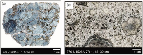
Applied use of ocean drilling results
Ocean drilling throughout its history has provided information of relevance to the petroleum and mineral exploration industries. In the petroleum area, this has largely been the stratigraphic and geochemical information gained from continental shelf and slope sites, frequently correlated seismically to nearby industry seismic data sets. In the minerals area this has largely been through the drilling of areas containing polymetallic sea-bed deposits. Not only is this important to those exploring offshore, but it has informed exploration and evaluation for onshore polymetallic deposits, many of which once formed beneath and at the seafloor.
Petroleum exploration
Interactions between the curiosity-driven science carried out by scientific ocean drilling and the applied interests of petroleum explorers have occurred since the Mohole Project. However, the local exploration industry’s knowledge of ocean drilling results or even the existence of the program has typically been limited. Direct interest is only present if our expeditions fall in or near exploration leases held by individual companies. Despite this, the stratigraphic drilling accomplished by IODP, and its predecessors is considered by industry and government agencies in assessments of the petroleum potential of frontier areas, especially if it can be tied to reconnaissance seismic surveys.
To help remedy this lack of knowledge, ANZIC and its partner organisations have invited industry scientists to join specialist tours of JOIDES Resolution when in Australian or New Zealand ports. In Australia’s case, this has been particularly successful when the vessel comes into Fremantle, with Perth being the home of the local petroleum exploration industry. Two port calls there, supported by the IODP Science Operators and local ocean drilling scientists, have each drawn 60–70 industry geoscientists and engineers aboard. It became clear that the industry personnel generally had little idea of the very different capabilities and activities of the scientific drilling program, compared with those of the offshore drilling industry, and the complementarity of the respective studies. They saw the potential value to their exploration activities. Some examples of relevant results are set out below.
Perhaps the first expedition to draw industry interest was DSDP Leg 27 (; Heirtzler et al., Citation1974), when a company geochemist was aboard. He was very interested in gas hydrates present in Java Trench Site 262 and wrote a report of the analyses he carried out and their significance (McIver, Citation1974). McIver described the gas contents of a number of canned samples as being almost entirely biogenic methane, with the sediments having the potential to generate thermogenic methane if buried deeply enough.
The Great Australian Bight ODP Leg 182 (; Feary et al., Citation2000) drilled a very thick seaward-dipping wedge of Pliocene to Quaternary carbonates. A surprising discovery was the presence of abundant brines rich in hydrogen sulfide, and large volumes of methane. IODP drilling preliminary proposal 926 entitled “Great Australian Bight Reflux Brines” states: “We choose this location so that we can build on the already existing geochemical data from Leg 182, and because the GAB is considered a modern analogue of Mesozoic carbonate systems, not only in geometry but also in its microbial ecology. The tantalising possibility is that we will gain an unprecedented glimpse into the microbial and organic geochemical processes that are responsible for the formation of a large portion of the world’s hydrocarbon resources.”
Exmouth Plateau ODP Leg 122 (; Haq et al., Citation2006; Williamson et al., Citation1989) continuously cored Lower Cretaceous deltaic sediments which host the giant, as yet undeveloped, Scarborough gas field. Upper Triassic (Rhaetian) reefal carbonates were drilled for the first time in Australia in other sites. Similar carbonates are large producers of hydrocarbons in Indonesia, so this discovery generated considerable industry interest in finding similar carbonates at depth elsewhere on the Exmouth Plateau. Woodside Petroleum sent geologists to the core store in Japan a few years ago to compare the ODP cores with similar rocks they had drilled in a dedicated exploration well.
ODP Leg 189 (; Exon et al., Citation2001) drilled five deep sites off Tasmania and on the South Tasman Rise. The sedimentary sequence records marine conditions from the Late Cretaceous (Maastrichtian) to the late Quaternary, with dominantly terrestrially derived sediments until the earliest Oligocene. These results are of particular interest to exploration in the Sorell Basin, west of Tasmania.
IODP Expedition 369 (; Hobbs et al., Citation2019) drilled four deep sites in the Naturaliste Plateau region. Total Organic Carbon (TOC) values were generally low, except in a few thin bands of Cretaceous black shales in Site U1513. However, in the eastern Mentelle Basin, Site U1515 penetrated the Valanginian unconformity into lowermost Cretaceous and Jurassic sedimentary rocks dipping at 20°. Wainman et al. (Citation2020) described this older fluvio-deltaic sequence in detail, with Type III terrestrial kerogens of little source rock significance. However, over a 176 m interval, the average (TOC) is 14.12 wt%, and the highest value is 46.15 wt%. High hydrogen index values from one 30 m interval (555 mg hyrocarbons/gmTOC) indicate the presence of Type 1 algal kerogens derived from Botryococcus and suggest substantial petroleum source rock potential. In contrast, the TOC measured at the Great Australian Bight Site U1512 was very low, as described previously in this review.
IODP Expedition 372 (; Pecher et al., Citation2019) reported results from coring the creeping part of the young Tuaheni landslide complex on New Zealand’s Hihurangi margin. Gas hydrates had been predicted from earlier studies, and the highest hydrate saturation, in the pores of coarse silts, was 5–50%. These hydrate deposits have generated potential petroleum exploration interest.
Mineral exploration
Mineral exploration in the deep sea has focussed on manganese nodules, manganese crusts, and polymetallic deposits. Only polymetallic deposits have been addressed by scientific ocean drilling, with two expeditions in the Australasian region that put emphasis on the fluid flux that forms them.
In the eastern Manus Basin north of PNG, a considerable number of marine geoscience expeditions by research institutes have investigated young, polymetallic sulfide deposits. As a result of these non-industry studies, ODP Leg 193 (Binns et al., Citation2002) drilled the actively tectonic PACMANUS region on a topographic high between the Djaul and Weitin faults southwest of New Ireland. The seafloor hydrothermal system is hosted by felsic volcanic rocks in an overall convergent plate margin setting. No ore deposits were drilled but the expedition revealed a great deal about the nature of the fluid flow that feeds the deposits.
Nearby deposits were investigated by Nautilus Minerals, which had taken up a deep-sea mining lease with Papua New Guinea for the large seafloor Solwara 1 deposit, at a water depth of about 1600 m, with a copper grade of approximately 7% and significant gold and silver enrichment. This lease was the first of its kind, globally.
Brothers submarine volcano, about 400 km north of New Zealand, is one of many volcanoes in the Kermadec Arc. IODP Expedition 376 (de Ronde et al., 2019a) drilled five sites on the extensively surveyed volcano. The expedition was designed to understand hydrothermal activity and mineral deposit formation at depth in submarine arc volcanoes, and the relationship between the discharge of magmatic fluids and the deep biosphere. The significance of this drilling is stated in the previous section.
Near- and longer-term future of scientific ocean drilling
Various national and international reviews of ocean drilling have been held in recent times, some of them focussed tightly on IODP itself, and others including its predecessors. This is obviously necessary when considering renewal of an operational program that costs about US$180 million annually for its logistics, has access to two large drill ships with a replacement value of about US$1.1 billion, and contracts specialised drill vessels for specific tasks in challenging environments. The additional costs of the science participants (carried by their own countries) amount to many millions of dollars per year.
A 10-year phase of ocean drilling from 2013 to 2023 was approved under the name International Ocean Discovery Program. The change of name from Integrated Ocean Drilling Program was necessary because the program was no longer integrated at the operational level, with those providing the vessels − the US, Japan and Europe − now having ultimate control of their programs. Also opportunities were broadened, for example because the new program included larger scale installation of suites of borehole observatories for which drilling is just an enabling tool. In late 2013, key funding support came from the US NSF, the Japanese Ministry of Education, Culture, Sports, Science and Technology (MEXT), and the ECORD.
As outlined in Scientific ocean drilling: the background facts, individual countries have approached funding of their engagement with the scientific ocean drilling programs in different ways, and at different stages of the funding cycle. Funding for the final years of IODP is under consideration separately by member nations, including the ANZIC consortium, which has funding until the end of 2022.
Over the past couple of years, a major community planning effort for the longer-term future of scientific ocean drilling has culminated in release of the “2050 Science Framework: Exploring Earth by Scientific Ocean Drilling” (Koppers & Coggon, Citation2020). This document (available on the web at https://www.iodp.org/2050-science-framework) provides a guide to the fundamental scientific research frontiers that ocean drilling can and should explore. The framework stresses the fundamental importance to human society of the interrelationships of the dynamic character of Earth, its climate and environments, and the emergence and continuity of life. These fundamentals are linked to the rates and cycles characterising processes such as location and intensity of natural hazards, and the health and habitability of the oceans. Seven strategic objectives comprise the foundational research areas of the framework: habitability and life on Earth, the oceanic life cycle of tectonic plates, Earth’s climate system, feedbacks in the Earth system, tipping points in Earth’s history, global cycles of energy and matter, and natural hazards impacting society. Multidisciplinary approaches are required to achieve these objectives and are encapsulated in five “flagship initiatives”: ground truthing future climate change, probing the deep Earth, assessing earthquake and tsunami hazards, diagnosing ocean health, and exploring life and its origins.
Conclusions
Scientific ocean drilling is the longest lived and best supported of all pure research programs in geoscience and is a wonderful example of international cooperation. It provided direct evidence of the reality of seafloor spreading and plate tectonics in 1968, by drilling to the oceanic basalts east and west of the mid-Atlantic spreading ridge. The basalts were proven to age away from the ridge in line with the geophysical predictions based on magnetic profiling. Since then, ocean drilling results have been a key element in the explosion of understanding of the tectonics and geological history of the world’s oceans, with substantial focus on the Australasian region. The broader tectonic framework has also controlled the paleolatitudes of dispersed continental fragments, and mountain building assocated with collisions between these fragments. The creation and destruction of oceans and seas associated with the tectonic evolution of the region has modulated paleoceanographic conditions and controlled our past and present onshore environments.
The ca 50 years of scientific ocean drilling in the Australasian region led to a revolution in our understanding of its geological history, and especially of the Cretaceous, Paleogene and Neogene. More than 50 regional expeditions have recovered more than 100 000 m of drill core, which is well stored and curated, and available to any scientist for examination. All results are placed in the public domain soon after they are initially obtained. Most drilling involves continuous coring. Ocean drilling is a treasure-house of geological information, with exhaustive expedition reports and tens of thousands of refereed publications. Borehole observatories provide information on local tectonics and fluid flow.
This paper has covered an area extending from the Izu–Bonin–Mariana Arc and parts of southern Asia in the north to the Antarctic margin in the south, and from India and the Kerguelen Plateau in the west to the central Pacific in the east. It includes the eastern Indian Ocean, the Southern Ocean and the western Pacific Ocean on the Indo-Australian Plate, and parts of the western Pacific Plate to the east and the north. The present-day bathymetric elements that have been extensively drilled include the continental margins, ridges and plateaus, and deep ocean basins.
The plate-tectonic history of the region is complex, and the geophysical evidence and the ocean drilling evidence are complementary in building the present coherent but evolving story. The drilling provides the nature and age of the volcanic and sedimentary rocks offshore, and the depth of the ocean (and indeed sometimes land) on which they were deposited. Without the drilling, the value of the geophysical evidence would be greatly reduced, and a plethora of unanswered questions would remain.
The Jurassic and Cretaceous breakup of Gondwana began with the separation and northward movement from Antarctica of India, Australia, various Asian fragments and much of New Zealand, as the Southeast Indian Ridge developed. The Cretaceous and younger collisions with central and southeast Asia are a large part of the story. The Cretaceous to Paleogene stripping of continental ribbons from Eastern Gondwana, to form the Southwest Pacific terrain consisting of the melded submarine continent of Zealandia, and the associated oceanic basins, make another major story.
About 50 million years ago the global plate-tectonic change of configuration added further complexity to the situation, with the volcanic arcs and backarc basins of the Pacific “Rim of Fire” extending from New Zealand northward and northwestward to form arcs and backarcs through what are now Tonga, Samoa, Fiji, Vanuatu, the Solomon Islands and Bougainville, and then into the highly complex New Guinea and Indonesian arcs and backarcs. Within the Pacific Plate, another array of tectonic features developed. A common story through all these times was the sinking of oceanic crust as it cooled, but to this was added various other tectonic complexities.
The nature of the volcanic crust of the ocean, including the spreading basins and the island arcs, reveals a great deal about the varied nature of the materials derived from the Earth’s crust and mantle, and the mechanisms by which the oceans spread and crust is emplaced. The subduction zones and related volcanic arcs have been a special topic of ocean drilling research. The associated geological hazards of volcanic eruptions, earthquakes, faulting and tsunamis, have also been the subject of considerable scientific effort.
The ocean is the long-term recipient of the material derived from the land, much of it being gravel, sand, silt, and mud carried into the ocean by rivers and then redeposited by downslope movement including mass slope failures and turbidity currents. The latter carry sediment thousands of kilometres out onto the abyssal plains. A great deal of terrigenous sediment also comes by the deposition of dust from wind erosion. Studies of largely terrigenous strata provide us with the most continuous records of the history of uplift, erosion, and climate on the adjacent land masses. Complementary information from planktonic and benthic fossils, sometimes found in high purity carbonate oozes, chalks or limestone, and sometimes in siliceous oozes or rocks, helps define the ages and environments in which they lived, including the water’s salinity, temperature, and chemical composition. Frequently, such organisms provide similar information in the largely terrigenous deposits.
The details and achievements of all the regional expeditions are outlined in the earlier sections and are summarised under the major scientific themes of climate change, ancient and modern life systems, planetary dynamics, and modern processes and hazards. Significant contributions to offshore petroleum and mineral exploration are also covered.
Ocean drilling started with the drilling of scattered holes to address the great unknowns of geoscience, and gradually became tightly focussed on solving globally relevant challenges. The achievements of ocean drilling have been critical with respect to all the questions it has dealt with, of which this paper gives the reader a sense. To take one particular area, ocean drilling has provided the great bulk of the information that we now take for granted in dealing with past oceanographic and climate changes on all time-scales, and that information is critical in developing robust global climate models that predict the future of the world in which we live. Nearly all ocean drilling has led onto other and often new global problems that need addressing, and it is impossible to tell where future drilling research will lead. On the other hand, it will certainly be exciting and relevant. Opportunities abound for engagement by Australian scientists with the next phase of scientific ocean drilling in its many faceted strategic objectives and initiatives.
Supplemental Material
Download PDF (283.9 KB)Acknowledgements
Without the generous financial and general support of numerous Australian and New Zealand universities and government agencies, and the Australian Research Council, the Australasian region would not have attracted the major effort by the scientific ocean drilling community over the last 50 years. Many colleagues have kindly provided various pieces of text that we have drawn on, and others have sent us potential figures and their captions, from which RJA has produced a selection. We have a huge debt of gratitude to Ron Hackney who prepared the beautiful and informative regional maps. Thorough and thoughtful reviews by Ted Moore at the University of Michigan and Ron Hackney have led to important improvements in the text.
Disclosure statement
No potential conflict of interest was reported by the author(s).
Additional information
Funding
References
- Abers, G. A., Ferris, A., Craig, M., Davies, H., Lerner-Lam, A. L., Mutter, J. C., & Taylor, B. (2002). Mantle compensation of active metamorphic core complexes at Woodlark rift in Papua New Guinea. Nature, 418(6900), 862–865. https://doi.org/https://doi.org/10.1038/nature00990
- Aiello, I. W., Bova, S. C., Holbourn, A. E., Kulhanek, D. K., Ravelo, A. C., & Rosenthal, Y. (2019). Climate, sea level and tectonic controls on sediment discharge from the Sepik River, Papua New Guinea during the Mid- to Late Pleistocene. Marine Geology, 415, 105954. https://doi.org/https://doi.org/10.1016/j.margeo.2019.05.013
- Ando, A., Khim, B.-K., Nakano, T., & Takata, H. M. (2011). Chemostratigraphic documentation of a complete Miocene intermediate-depth section in the Southern Ocean: Ocean Drilling Program Site 1120, Campbell Plateau off New Zealand. Marine Geology, 279(1–4), 52–62. https://doi.org/https://doi.org/10.1016/j.margeo.2010.10.012
- Arculus, R. J., Bogus, K., & the Expedition 351 Scientists. (2015). Proceedings of the international ocean discovery program, expedition 351: Izu-Bonin-Mariana Arc origins. International Ocean Discovery Program. http://publications.iodp.org/proceedings/351/351title.html
- Arculus, R. J., Gurnis, M., Ishizuka, O., Reagan, M. K., Pearce, J. A., & Sutherland, R. (2019). How to create new subduction zones: A global perspective. Oceanography, 32(1), 160–174. https://doi.org/https://doi.org/10.5670/oceanog.2019.140
- Baker, E., Keene, J. (2004). Full fathom five, 15 years of Australian involvement in the ocean drilling program. Australian ODP Office (Sydney University). https://openresearch-repository.anu.edu.au/handle/1885/159373
- Baldwin, S. L., Webb, L. E., & Monteleone, B. D. (2008). Late Miocene coesite-eclogite exhumed in the Woodlark Rift. Geology, 36(9), 735–738. https://doi.org/https://doi.org/10.1130/G25144A.1
- Barnes, P. M., Wallace, L. M., Saffer, D. M., Bell, R. E., Underwood, M. B., Fagereng, A., Meneghini, F., Savage, H. M., Rabinowitz, H. S., Morgan, J. K., Kitajima, H., Kutterolf, S., Hashimoto, Y., Engelmann de Oliveira, C. H., Noda, A., Crundwell, M. P., Shepherd, C. L., Woodhouse, A. D., Harris, R. N., … LeVay, L. J, & the Expedition 372 Scientists. (2020). Slow slip source characterized by lithological and geometric heterogeneity. Science Advances, 6(13), eaay3314. https://doi.org/https://doi.org/10.1126/sciadv.aay3314
- Barron, J., Larsen, B, & the Expedition 119 Scientists. (1989). Proceedings ocean drilling program initial report, 119 (p. 553). Ocean Drilling Program; Texas A & M University. https://doi.org/https://doi.org/10.2973/odp.proc.ir.119.1989
- Bascom, W. (1961). A hole in the bottom of the sea, the story of the Mohole Project. Doubleday & Company, Inc.
- Becker, K., Austin, J. A., Exon, N., Humphris, S., Kastner, M., McKenzie, J. A., Miller, K. G., Suyehiro, K., Taira, A, & University of Miami. (2019). Years of scientific ocean drilling. Oceanography, 32(1), 17–21. https://doi.org/https://doi.org/10.5670/oceanog.2019.110
- Berger, W. H., Kroenke, L. W., Mayer, L. A, & the Expedition 130 Scientists. (1993a). Proceedings ocean drilling program scientific report 130 (p. 750). Ocean Drilling Program. https://doi.org/https://doi.org/10.2973/odp.proc.sr.130.1993
- Berger, W. H., Kroenke, L. W., Mayer, L. A, & the Expedition 130 Scientists (1993b). Ontong Java Plateau, leg 130: Synopsis of major drilling results. In Proceedings Ocean Drilling Program Scientific Report 130 (pp. 497––537). Ocean Drilling Program. https://doi.org/https://doi.org/10.2973/odp.proc.ir.130.110.1991
- Beslier, M.-O., Royer, J.-Y., Girardeau, J., Hill, P. J., Boeuf, E., Buchanan, C., Chatin, F., Jacovetti, G., Moreau, A., Munschy, M., Partouche, C., Robert, U., & Thomas, S. (2004). A wide ocean-continent transition along the south-west Australian margin: First results of the MARGAU/MD110 cruise. Bulletin de la Société Géologique de France, 175(6), 629–641. https://doi.org/https://doi.org/10.2113/175.6.629
- Betzler, C., & Eberli, G. P. (2019). Miocene start of modern carbonate platforms. Geology, 47(8), 771–775. https://doi.org/https://doi.org/10.1130/G45994.1
- Betzler, C., Eberli, G. P., Lüdmann, T., Reolid, J., Kroon, D., Reijmer, J. J. G., Swart, P. K., Wright, J., Young, J. R., Alvarez-Zarikian, C., Alonso-García, M., Bialik, O. M., Blättler, C. L., Guo, J. A., Haffen, S., Horozal, S., Inoue, M., Jovane, L., Lanci, L., … Yao, Z. (2018). Refinement of Miocene sea level and monsoon events from the sedimentary archive of the Maldives (Indian Ocean). Progress in Earth and Planetary Science, 5(1), 5. https://doi.org/https://doi.org/10.1186/s40645-018-0165-x
- Bickle, M., Arculus, R., Barrett, P., De Conto, R., Camoin, G., Edwards, K., Fisher, A., Inagaki, F., Kodaira, S., Ohkouchi, N., Pälike, H., Ravelo, C., Saffer, D., Teagle, D. (2011). Illuminating Earth’s Past, Present and Future: Science Plan for 2013–2023 (p. 84). The International Ocean Discovery Program. http://www.iodp.org/Science-Plan-for-2013-2023/
- Binns, R. A., Barriga, F. J. A. S., Miller, D. J, & the Expedition 193 Scientists. (2002). Anatomy of an active felsic-hosted hydrothermal system, eastern Manus Basin. In Proceedings ocean drilling program initial reports 193. Ocean Drilling Program. https://doi.org/https://doi.org/10.2973/odp.proc.ir.193.2002
- Binns, R. A., Barriga, F. J. A. S., Miller, D. J, & the Expedition 193 Scientists. (2007). 1. Leg 193 Synthesis: Anatomy of an active felsic-hosted hydrothermal system, eastern Manus Basin, Papua New Guinea. Proceedings Ocean Drilling Program Scientific Reports 193. Ocean Drilling Program. https://doi.org/https://doi.org/10.2973/odp.proc.sr.193.201.2007
- Bird, P. (2003). An updated digital model of plate boundaries. Geochemistry, Geophysics, Geosystems, 4(3), 1027. https://doi.org/https://doi.org/10.1029/2001GC000252
- Bloomer, S. H., & Fisher, R. L. (1987). Petrology and geochemistry of igneous rocks from the Tonga Trench: A non-accreting plate boundary. The Journal of Geology, 95(4), 469–495. https://doi.org/https://doi.org/10.1086/629144
- Bloomer, S. H., Ewart, A., Hergt, J. M., Bryan, W. B. (1994). 38. Geochemistry and origin of igneous rocks from the outer Tonga forearc (Site 841). Proceedings of the Ocean Drilling Program, Scientific Results, 136, 625–646. http://www-odp.tamu.edu/publications/135_SR/VOLUME/CHAPTERS/sr135_38.pdf
- Borissova, I. (2002). Geological framework of the Naturaliste Plateau. Geoscience Australia Record 2002/20, 44 p, plus 21 figures and 4 plates. https://d28rz98at9flks.cloudfront.net/40535/Rec2002_020.pdf
- Borissova, I., Moore, A., Sayers, J., Parums, R., Coffin, M. F., Symonds, P. A. (2002). Geological framework of the Kerguelen Plateau and adjacent ocean basins. Geoscience Australia Record, 2002/05. https://d28rz98at9flks.cloudfront.net/38753/Rec2002_005.pdf
- Brandl, P. A., Hamada, M., Arculus, R. J., Johnson, K., Marsaglia, K. M., Savov, I. P., Ishizuka, O., & Li, H. (2017). The arc arises: The links between volcanic output, arc evolution and melt composition. Earth and Planetary Science Letters, 461, 73–84. https://doi.org/https://doi.org/10.1016/j.epsl.2016.12.027
- Broecker, W. S. (1991). The Great Ocean conveyor. Oceanography, 4(2), 79–89. https://doi.org/https://doi.org/10.5670/oceanog.1991.07
- Bryan, S. E., Ewart, A., Stephens, C. J., Parianos, J., & Downes, P. J. (2000). The Whitsunday Volcanic Province, Central Queensland, Australia: Lithological and stratigraphic investigations of a silicic-dominated large igneous province. Journal of Volcanology and Geothermal Research, 99(1–4), 55–78. https://doi.org/https://doi.org/10.1016/S0377-0273(00)00157-8
- Buffler, R. T., Rowell, P., Exon, N. F. (1992). Seismic stratigraphy of the Site 766 area, western margin of the Exmouth Plateau, Australia. Proceedings of the Ocean Drilling Program, Scientific Results, 123, 563–582. https://doi.org/https://doi.org/10.2973/odp.proc.sr.123.1992
- Burke, K., Steinberger, B., Torsvik, T. H., & Smethurst, M. A. (2008). Plume generation zones at the margins of large low shear velocity provinces on the core-mantle boundary. Earth and Planetary Science Letters, 265(1–2), 49–60. https://doi.org/https://doi.org/10.1016/j.epsl.2007.09.042
- Burns, R. E., & Andrews, J. E. (1973). Initial reports of the deep sea drilling project 21 (p. 923). US Government Printing Office. https://doi.org/https://doi.org/10.2973/dsdp.proc.21.1973
- Busby, C. J., Tamura, Y., Blum, P., Guèrin, G., Andrews, G. D. M., Barker, A. K., Berger, J. L. R., Bongiolo, E. M., Bordiga, M., DeBari, S. M., Gill, J. B., Hamelin, C., Jia, J., John, E. H., Jonas, A.-S., Jutzeler, M., Kars, M. A. C., Kita, Z. A., Konrad, K., … Yang Yang, A. (2017). The missing half of the subduction factory: Shipboard results from the Izu rear arc, IODP Expedition 350. International Geology Review, 59(13), 1677–1708. https://doi.org/https://doi.org/10.1080/00206814.2017.1292469
- Carter, L., Carter, R. M., & McCave, I. N. (2004). Evolution of the sedimentary system beneath the deep Pacific inflow off eastern New Zealand. Marine Geology, 205(1–4), 9–27. https://doi.org/https://doi.org/10.1016/S0025-3227(04)00016-7
- Carter, L., Neil, H. L., & McCave, I. N. (2000). Glacial to interglacial changes in non-carbonate and carbonate accumulation in the SW Pacific Ocean, New Zealand. Palaeogeography, Palaeoclimatology, Palaeoecology, 162(3–4), 333–356. https://doi.org/https://doi.org/10.1016/S0031-0182(00)00137-1
- Carter, L., Shane, P., Alloway, B., Hall, I. R., Harris, S. E., & Westgate, J. A. (2003). Demise of one volcanic zone and birth of another – a 12 m.y. marine record of major rhyolitic eruptions from New Zealand. Geology, 31(6), 493–496. https://doi.org/https://doi.org/10.1130/0091-7613(2003)031<0493:DOOVZA>2.0.CO;2
- Carter, R. M., & Landis, C. A. (1972). Correlative Oligocene unconformities in southern Australasia. Nature Physical Science, 237(70), 12–13. https://doi.org/https://doi.org/10.1038/physci237012a0
- Carter, R. M., Carter, L., & McCave, I. N. (1996). Current controlled sediment deposition from the shelf to the deep ocean: The Cenozoic evolution of circulation through the SW Pacific gateway. Geologische Rundschau, 85(3), 438–451. https://doi.org/https://doi.org/10.1007/BF02369001
- Carter, R. M., McCave, I. N., Carter, L. (2004). Leg 181 synthesis: Fronts, flows, drifts, volcanoes, and the evolution of the southwestern gateway to the Pacific Ocean, eastern New Zealand. In C. Richter (Ed.), Proceedings of the Ocean Drilling Program, Scientific Results, 181 (pp. 1–111). Ocean Drilling Program. http://www-odp.tamu.edu/publications/181_SR/VOLUME/SYNTH/SYNTH.PDF
- Castillo, P. R. (2015). The recycling of marine carbonates and sources of HIMU and FOZO ocean island basalts. Lithos, 216–217, 254–263. https://doi.org/https://doi.org/10.1016/j.lithos.2014.12.005
- Chandler, M. T., Wessel, P., & Taylor, B. (2015). Tectonic reconstructions in magnetic quiet zones: Insights from the Greater Ontong Java Plateau. Geological Society of America Special Paper, 511, 185–193. https://doi.org/https://doi.org/10.1130/2015.2511(10)
- Chandler, M. T., Wessel, P., Taylor, B., Seton, M., Kim, S.-S., & Hyeong, K. (2012). Reconstructing Ontong Java Nui: Implications for Pacific absolute plate motion, hotspot drift and true polar wander. Earth and Planetary Science Letters, 331-332, 140–151. https://doi.org/https://doi.org/10.1016/j.epsl.2012.03.017
- Christie, D. M., Pyle, D. G., Pedersen, R. B., Miller, D. J. (2004). Leg 187 synthesis: Evolution of the Australian Antarctic Discordance, the Australian Antarctic depth anomaly, and the Indian/Pacific mantle isotopic boundary. Proceedings of the Ocean Drilling Program, Scientific Results, 187, 1–41. https://doi.org/https://doi.org/10.2973/odp.proc.sr.187.201.2004
- Christie, D. M., West, B. P., Pyle, D. G., & Hanan, B. B. (1998). Chaotic topography, mantle flow and mantle migration in the Australian-Antarctic Discordance. Nature, 394(6694), 637–644. https://doi.org/https://doi.org/10.1038/29226
- Clemens, S. C., Kuhnt, W., LeVay, L. J, & the Expedition 353 Scientists. (2016). Indian Monsoon Rainfall. Proceedings of the International Ocean Discovery Program, 353. International Ocean Discovery Program. https://doi.org/https://doi.org/10.14379/iodp.proc.353.2016
- Clift, P. D., & Webb, A. G. (2019). A history of the Asian monsoon and its interactions with solid Earth tectonics in Cenozoic South Asia. In P. J. Treloar & M. P. Searle (Eds.), Himalayan tectonics: A modern synthesis (Vol. 483, pp. 631–652). Geological Society, London, Special Publications. https://doi.org/https://doi.org/10.1144/SP483.1
- Coffin, M. F., Frey, F. A., Wallace, P. J, & the Expedition 183 Scientists. (2000). Proceedings ocean drilling program initial report 183. Ocean Drilling Program. https://doi.org/https://doi.org/10.2973/odp.proc.ir.183.2000
- Collot, J.-Y., Greene, H. G., Stokking, L. B, & the Expedition 134 Scientists. (1992). Proceedings ocean drilling program initial report 134. Ocean Drilling Program. https://doi.org/https://doi.org/10.2973/odp.proc.ir.134.1992
- Conference Participants. (1972). Penrose Field Conference: Ophiolites. Geotimes, 17, 24–25.
- Cooper, A. K., O’Brien, P. E. (2004). Leg 188 synthesis: Transitions in the glacial history of the Prydz Bay region, East Antarctica, from ODP drilling. In Proceedings ocean drilling program, scientific results, 188. Texas A & M University (Ocean Drilling Program). https://doi.org/https://doi.org/10.2973/odp.proc.sr.187.201.2004
- Corry-Saavedra, K., Schindlbeck, J. C., Straub, S. M., Murayama, M., Bolge, L. L., Gómez-Tuena, A., Hashimoto, Y., & Woodhead, J. D. (2019). The role of dispersed ash in orbital-scale time-series studies of explosive arc volcanism: Insights from IODP Hole U1437B, Northwest Pacific Ocean. International Geology Review, 61(17), 2164–2183. https://doi.org/https://doi.org/10.1080/00206814.2019.1584770
- Cottin, J. Y., Michon, G., Delpech, G. (2011). The Kerguelen volcanic plateau: The second largest oceanic Igneous Province (LIP) on Earth and a witness of the Indian Ocean opening. In D. Welsford, J. Dell & G. Duhamel (Eds.), The Kerguelen Plateau. Marine ecosystems and fisheries proceedings of the second symposium (pp. 29–42). Australian Antarctic Division.
- Covellone, B. M., Savage, B., & Shen, Y. (2015). Seismic wave speed structure of the Ontong Java Plateau. Earth and Planetary Science Letters, 420, 140–150. https://doi.org/https://doi.org/10.1016/j.epsl.2015.03.033
- Craddock, P. R., & Bach, W. (2010). Insights to magmatic–hydrothermal processes in the Manus back-arc basin as recorded by anhydrite. Geochimica et Cosmochimica Acta, 74(19), 5514–5536. https://doi.org/https://doi.org/10.1016/j.gca.2010.07.004
- Crawford, A. J., Meffre, S., & Symonds, P. A. (2003). 120 to 0 Ma tectonic evolution of the southwest Pacific and analogous geological evolution of the 600 to 220 Ma Tasman Fold Belt system. Geological Society of Australia Special Publication, 22, 383–403.
- Crossingham, T. J., Vasconcelos, P. M., Cunningham, T., & Knesel, K. M. (2017). 40Ar/39Ar geochronology and volume estimates of the Tasmantid Seamounts: Support for a change in the motion of the Australian plate. Journal of Volcanology and Geothermal Research, 343, 95–108. https://doi.org/https://doi.org/10.1016/j.jvolgeores.2017.06.014
- D’Hondt, S., Inagaki, F., Alvarez Zarikian, C. A., & the Expedition 329 Scientists. (2011). South Pacific gyre subseafloor life, 329. In Proceedings of the International Ocean Discovery Program, 329. Integrated Ocean Drilling Program Management International, Inc. https://doi.org/https://doi.org/10.2204/iodp.proc.329.112.2011
- Dang, H., Peng, N., Ma, X., Wan, S., & Jian, Z. (2020). Possible linkage between the long-eccentricity marine carbon cycle and the deep-Pacific circulation: Western equatorial Pacific benthic foraminifera evidences of the last 4 Ma. Marine Micropaleontology, 155, 101797. https://doi.org/https://doi.org/10.1016/j.marmicro.2019.101797
- Davies, D. R., Goes, S., & Sambridge, M. (2015). On the relationship between volcanic hotspot locations, the reconstructed eruption sites of large igneous provinces and deep mantle seismic structure. Earth and Planetary Science Letters, 411, 121–130. https://doi.org/https://doi.org/10.1016/j.epsl.2014.11.052
- Davies, P. J., McKenzie, J. A., & the Expedition 133 Scientists. (1973). Northeast Australian margin. In Proceedings Ocean Drilling Program, Initial Reports, 133 (p. 810). Ocean Drilling Program. https://doi.org/https://doi.org/10.2973/odp.proc.ir.133.1991
- Davies, T. A., & Luyendyk, B. P. (1974). Initial reports of the deep sea drilling project, 26 (p. 1121). US Government Printing Office.
- Davies, T. A., Weser, E. O., Luyendyk, B. P., & Kidd, R. B. (1975). Unconformities in the sediments of the Indian Ocean. Nature, 253(5486), 15–19. https://doi.org/https://doi.org/10.1038/253015a0
- De Ronde, C. E. J., Humphris, S. E., & Höfig, T. W, & the Expedition 376 Scientists (2019a). Brothers Arc Flux, 376. International Ocean Discovery Program. https://doi.org/https://doi.org/10.14379/iodp.proc.376.2019
- De Ronde, C. E. J., Humphris, S. E., Höfig, T. W., & Reyes, A. G, & the Expedition 376 Scientists (2019b). Critical role of caldera collapse in the formation of seafloor mineralization: The case of Brothers volcano. Geology, 47(8), 762–766. https://doi.org/https://doi.org/10.1130/G46047.1
- Debret, B., Albers, E., Walter, B., Price, R., Barnes, J. D., Beunon, H., Facq, S., Gillikin, D. P., Mattielli, N., & Williams, H. (2019). Shallow forearc mantle dynamics and geochemistry: New insights from IODP Expedition 366. Lithos, 326–327, 230–245. https://doi.org/https://doi.org/10.1016/j.lithos.2018.10.038
- Dewey, J. F. (1975). Plate tectonics. Reviews of Geophysics, 13(3), 326–332. https://doi.org/https://doi.org/10.1029/RG013i003p00326
- Dick, H. J. B., MacLeod, C. J., Blum, P., Abe, N., Blackman, D. K., Bowles, J. A., Cheadle, M. J., Cho, K., Ciazela, J., Deans, J. R., Edgcomb, V. P., Ferrando, C., France, L., Ghosh, B., Ildefonse, B., John, B., Kendrick, M. A., Koepke, J., Leong, J. A. M., … Viegas, G. (2019). Dynamic accretion beneath a slow‐spreading ridge segment: IODP Hole 1473A and the Atlantis Bank Oceanic Core Complex. Journal of Geophysical Research: Solid Earth, 124(12), 12631–12659. https://doi.org/https://doi.org/10.1029/2018JB016858
- Direen, N. G., Cohen, B. E., Maas, R., Frey, F. A., Whittaker, J. M., Coffin, M. F., Meffre, S., Halpin, J. A., & Crawford, A. J. (2017). Naturaliste Plateau: Constraints on the timing and evolution of the Kerguelen large igneous province and its role in Gondwana breakup. Australian Journal of Earth Sciences, 64(7), 851–869. https://doi.org/https://doi.org/10.1080/08120099.2017.1367326
- Doré, T., & Lundin, E. (2015). Hyperextended continental margins – knowns and unknowns. Geology, 43(1), 95–96. https://doi.org/https://doi.org/10.1130/focus012015.1
- Dugan, B., McNeill, L., & Petronotis, K, & the Expedition 362 Scientists. (2017). Expedition 362 preliminary report: Sumatra Subduction Zone (p. 31). International Ocean Discovery Program. https://doi.org/https://doi.org/10.14379/iodp.pr.362.2017
- Duncan, R. A. (1978). Geochronology of basalts from the Ninetyeast Ridge and continental dispersion in the eastern Indian Ocean. Journal of Volcanology and Geothermal Research, 4(3–4), 283–305. https://doi.org/https://doi.org/10.1016/0377-0273(78)90018-5
- Duncan, R. A. (1991). Age distribution of volcanism along aseismic ridges in the eastern Indian Ocean. In J. Weissel, J. Peirce, E. Taylor, J. Alt, (Eds.), proceedings ocean drilling program initial report (Vol. 134, pp. 507–517). Ocean Drilling Program, 121. http://www-odp.tamu.edu/PUBLICATIONS/121_SR/VOLUME/CHAPTERS/sr121_26.pdf
- Duncan, R. A., Rea, D. K., Kidd, R. B., von Rad, U., & Weissel, J. K. (1992). Synthesis of results from scientific drilling in the Indian Ocean (Vol. 70). American Geophysical Union, Geophysical Monograph.
- Dupré, B., & Allègre, C. J. (1983). Pb–Sr isotope variation in Indian Ocean basalts and mixing phenomena. Nature, 303(5913), 142–146. https://doi.org/https://doi.org/10.1038/303142a0
- Dutkiewicz, A., O'Callaghan, S., & Müller, R. D. (2016). Controls on the distribution of deep-sea sediments. Geochemistry, Geophysics, Geosystems, 17(8), 3075–3098. https://doi.org/https://doi.org/10.1002/2016GC006428
- Dyriw, N. J., Bryan, S. E., Richards, S. W., Parianos, J. M., Arculus, R. J., & Gust, D. A. (2021). Morphotectonic analysis of the East Manus Basin, Papua New Guinea. Frontiers in Earth Science, 8. https://doi.org/https://doi.org/10.3389/feart.2020.596727
- East, M., Müller, R. D., Williams, S., Zahirovic, S., & Heine, C. (2020). Subduction history reveals Cretaceous slab superflux as a possible cause for the mid-Cretaceous plume pulse and superswell events. Gondwana Research, 79, 125–139. https://doi.org/https://doi.org/10.1016/j.gr.2019.09.001
- Engel, C. G., & Engel, A. E. J. (1961). Composition of basalt cored in Mohole Project. Bulletin of the American Association of Petroleum Geologists, 45(11), 1799. https://doi.org/https://doi.org/10.1306/BC743731-16BE-11D7-8645000102C1865D
- Escutia, C., Brinkhuis, H., Klaus, A, & the Expedition 318 Scientists. (2011). Wilkes Land glacial history. In Proceedings of the integrated Ocean Drilling Program (Vol. 318). https://doi.org/https://doi.org/10.2204/iodp.proc.318.2011
- Escutia, C., DeConto, R., Dunbar, R., De Santis, L., Shevenell, A., & Nash, T. (2019). Keeping an eye on Antarctic Ice Sheet stability. Oceanography, 32(1), 32–46. https://doi.org/https://doi.org/10.5670/oceanog.2019.117
- Exon, N. (2017). Exploring the earth under the sea: Australian and New Zealand achievements in the first phase of IODP scientific ocean drilling, 2008–2013 (p. 213). ANU Press. https://doi.org/https://doi.org/10.22459/EEUS.10.2017
- Exon, N. F., Kennett, J. P., & Malone, M. J. (Eds.) (2004). The Cenozoic Southern Ocean: Tectonics, sedimentation and climate change between Australia and Antarctica (Vol. 151, p. 367). American Geophysical Union, Geophysical Monograph. https://agupubs.onlinelibrary.wiley.com/doi/book/https://doi.org/10.1029/GM151
- Exon, N. F., Kennett, J. P., & Malone, M. J, & the Expedition 189 Scientists. (2001). The Tasmanian Gateway: Cenozoic climatic and oceanographic development (Initial Reports, 189). Ocean Drilling Program. https://doi.org/https://doi.org/10.2973/odp.proc.ir.189.2001
- Falloon, T. J., Meffre, S., Crawford, A. J., Hoernle, K., Hauff, F., Bloomer, S. H., & Wright, D. J. (2014). Cretaceous fore-arc basalts from the Tonga arc: Geochemistry and implications for the tectonic history of the SW Pacific. Tectonophysics, 630, 21–32. https://doi.org/https://doi.org/10.1016/j.tecto.2014.05.007
- Feary, D. A., Hine, A. C., & Malone, M. J, & the Expedition 182 Scientists. (2000). Great Australian Bight, Initial Reports, 182. Ocean Drilling Program. https://doi.org/https://doi.org/10.2973/odp.proc.ir.182.2000
- Finlayson, V. A., Konter, J. G., Konrad, K., Koppers, A. A. P., Jackson, M. G., & Rooney, T. O. (2018). Sr–Pb–Nd–Hf isotopes and 40Ar/39Ar ages reveal a Hawaii-Emperor-style bend in the Rurutu hotpsot. Earth and Planetary Science Letters, 500, 168–179. https://doi.org/https://doi.org/10.1016/j.epsl.2018.08.020
- Fitton, J. G., & Godard, M. (2004). Origin and evolution of magmas on the Ontong Java Plateau. In J. G. Fitton, J. J. Mahoney, P. J. Wallace, & A. D. Saunders (Eds), Origin and evolution of the Ontong Java Plateau (pp. 151178). Geological Society, London, Special Publications. 229.
- France-Lanord, C., Spiess, V., Klaus, A., Schwenk, T., & the Expedition 354 Scientists. (2016). Bengal Fan. In Proceedings of the international ocean discovery program, 354. International Ocean Discovery Program. https://doi.org/https://doi.org/10.14379/iodp.proc.354.2016
- French, S. W., & Romanowicz, B. (2015). Broad plumes rooted at the base of the Earth's mantle beneath major hotspots. Nature, 525(7567), 95–112. https://doi.org/https://doi.org/10.1038/nature14876
- Frey, F. A., Coffin, M. F., Wallace, P. J., Weis, D., Zhao, X., Wise, S. W. Jr., Wähnert, V., Teagle, D. A. H., Saccocia, P. J., Reusch, D. N., Pringle, M. S., Nicolaysen, K. E., Neal, C. R., Müller, R. D., Moore, C. L., Mahoney, J. J., Keszthelyi, L., Inokuchi, H., Duncan, R. A.,. Antretter, M. (2000). Origin and evolution of a submarine large igneous province: The Kerguelen Plateau and Broken Ridge, southern Indian Ocean. Earth and Planetary Science Letters, 176, 73–89. https://doi.org/https://doi.org/10.1016/S0012-821X(99)00315-5
- Frey, F. A., Nobre Silva, I. G., Huang, S., Pringle, M. S., Meleney, P., & Weis, D. (2015). Depleted components in the source of hotspot magmas: Evidence from the Ninetyeast Ridge (Kerguelen). Earth and Planetary Science Letters, 426, 293–304. https://doi.org/https://doi.org/10.1016/j.epsl.2015.06.005
- Frey, F. A., Pringle, M., Meleney, P., Huang, S., & Piotrowski, A. (2011). Diverse mantle sources for Ninetyeast Ridge magmatism: Geochemical constraints from basaltic glasses. Earth and Planetary Science Letters, 303(3–4), 215–224. https://doi.org/https://doi.org/10.1016/j.epsl.2010.12.051
- Frey, F. A., Weis, D., Borisova, A. Y., & Xu, G. (2002). Involvement of continental crust in the formation of the Cretaceous Kerguelen Plateau: New perspectives from IODP Leg 120 sites. Journal of Petrology, 43(7), 1207–1239. https://doi.org/https://doi.org/10.1093/petrology/43.7.1207
- Fullerton, L. G., Sager, W. W., & Handschumacher, D. W. (1989). Late Jurassic–Early Cretaceous evolution of the eastern Indian Ocean adjacent to Northwest Australia. Journal of Geophysical Research: Solid Earth, 94(B3), 2937–1157. https://doi.org/https://doi.org/10.1029/JB094iB03p02937
- Fulthorpe, C. S., Hoyanagi, K., Blum, P, & the Expedition 317 Scientists. (2011). Canterbury Basin sea level. In Proceedings ocean drilling program, 317. Integrated Ocean Drilling Program Management International, Inc. https://doi.org/https://doi.org/10.2204/iodp.proc.317.2011
- Fulton, P. M., Brodsky, E. E., Kano, Y., Mori, J., Chester, F., Ishikawa, T., Harris, R. N., Lin, W., Eguchi, N., Toczko, S, & Expedition 343, 343T, and KR13-08 Scientists. (2013). Low coseismic friction on the Tohoku-Oki fault determined from temperature measurements. Science (New York, N.Y.), 342(6163), 1214–1217. https://doi.org/https://doi.org/10.1126/science.1243641
- Gallagher, S. J., Fulthorpe, C. S., & Bogus, K, & the Expedition 356 Scientists. (2017). International Ocean Discovery Program Expedition Preliminary Report 356. International Ocean Discovery Program. https://doi.org/https://doi.org/10.14379/iodp.pr.356.2017
- Gallais, F., Fujie, G., Boston, B., Hackney, R., Kodaira, S., Miura, S., Nakamura, Y., & Kaiho, Y. (2019). Crustal structure across the Lord Howe Rise, Northern Zealandia, and rifting of the Eastern Gondwana Margin. Journal of Geophysical Research: Solid Earth, 124(3), 3036–3056. https://doi.org/https://doi.org/10.1029/2018JB016798
- Gardner, R. L., Daczko, N. R., Halpin, J. A., & Whittaker, J. M. (2015). Discovery of a microcontinent (Gulden Draak Knoll) offshore Western Australia: Implications for East Gondwana reconstructions. Gondwana Research, 28(3), 1019–1031. https://doi.org/https://doi.org/10.1016/j.gr.2014.08.013
- Garnero, E. J., Lay, T., & McNamara, A. (2007). Implications of lower-mantle structural heterogeneity for the existence and nature of whole-mantle plumes. In G. R. Foulger & D. M. Jurdy (Eds), Plates, plumes, and planetary processes (pp. 79101, Vol. 430). Geological Society of America Special Paper. https://doi.org/https://doi.org/10.1130/2007.2430(05)
- Gasson, E. G., & Keisling, B. A. (2020). The Antarctic ice sheet. Oceanography, 33(2), 90–100. https://doi.org/https://doi.org/10.5670/oceanog.2020.208
- Gibbons, A. D., Barckhausen, U., von den Bogaard, P., Hoernle, K., Werner, R., Whittaker, J. M., & Müller, R. D. (2012). Constraining the Jurassic extent of Greater India: Tectonic evolution of the West Australian margin. Geochemistry, Geophysics, Geosystems, 13. https://doi.org/https://doi.org/10.1029/2011GC003919
- Gibbons, A. D., Whittaker, J. M., & Müller, R. D. (2013). The breakup of East Gondwana: Assimilating constraints from Cretaceous ocean basins around India into a best-fit tectonic model. Journal of Geophysical Research: Solid Earth, 118(3), 808–822. https://doi.org/https://doi.org/10.1002/jgrb.50079
- Gill, J. B., Bongiolo, E. M., Miyazaki, T., Hamelin, C., Jutzeler, M., DeBari, S., Jonas, A.-S., Vaglarov, B. S., Nascimento, L. S., & Yakavonis, M. (2018). Tuffaceous mud is a volumetrically important volcaniclastic facies of submarine arc volcanism and record of climate change. Geochemistry, Geophysics, Geosystems, 19(4), 1217–1243. https://doi.org/https://doi.org/10.1002/2017GC007300
- Golowin, R., Portnyagin, M., Hoernle, K., Hauff, F., Gurenko, A., Garbe-Schönberg, D., Werner, R., & Turner, S. (2017). Boninite-like intraplate magmas from Manihiki Plateau require ultra-depleted and enriched source components. Nature Communications, 8(1), 14322 https://doi.org/https://doi.org/10.1038/ncomms14322
- Gray, M., Bell, R. E., Morgan, J. V., Henrys, S., Barker, D. H, & IODP Expedition 372 and 375 Science Parties. (2019). Imaging the shallow subsurface structure of the North Hikurangi Subduction Zone, New Zealand, using 2‐D full‐waveform inversion. Journal of Geophysical Research: Solid Earth, 124(8), 9049–9074. https://doi.org/https://doi.org/10.1029/2019JB017793
- Gurnis, M., & Müller, R. D. (2003). Origin of the Australian–Antarctic Discordance from an ancient slab and mantle wedge. In R. R. Hillis & R. D. Müller (Eds.), Evolution and dynamics of the Australian Plate (Vol. 372, pp. 417–429). Geological Society of Australia Special Publication 22 and Geological Society of America Special Paper. https://doi.org/https://doi.org/10.1130/0-8137-2372-8.417
- Gurnis, M., Kominz, M., & Gallagher, S. J. (2020). Reversible subsidence on the North West Shelf of Australia. Earth and Planetary Science Letters, 534, 116070. https://doi.org/https://doi.org/10.1016/j.epsl.2020.116070
- Gurnis, M., Van Avendonk, H., Gulick, S. P. S., Stock, J., Sutherland, R., Hightower, E., Shuck, B., Patel, J., Williams, E., Kardell, D., Herzig, E., Idini, B., Graham, K., Estep, J., & Carrington, L. (2019). Incipient subduction at the contact with stretched continental crust: The Puysegur Trench. Earth and Planetary Science Letters, 520, 212–219. https://doi.org/https://doi.org/10.1016/j.epsl.2019.05.044
- Halpin, J. A., Crawford, A. J., Direen, N. G., Coffin, M. F., Forbes, C. J., & Borissova, I. (2008). Naturaliste Plateau, offshore Western Australia: A submarine window into Gondwana assembly and breakup. Geology, 36(10), 807–810. https://doi.org/https://doi.org/10.1130/G25059A.1
- Halpin, J. A., Daczko, N. R., Kobler, M. E., & Whittaker, J. M. (2017). Strike-slip tectonics during the Neoproterozoic–Cambrian assembly of East Gondwana: Evidence from a newly discovered microcontinent in the Indian Ocean (Batavia Knoll). Gondwana Research, 51, 137–148. https://doi.org/https://doi.org/10.1016/j.gr.2017.08.002
- Hanan, B. B., Blichert-Toft, J., Pyle, D. G., & Christie, D. M. (2004). Contrasting origins of the upper mantle revealed by hafnium and lead isotopes from the Southeast Indian Ridge. Nature, 432(7013), 91–96. https://doi.org/https://doi.org/10.1038/nature03026
- Haq, B. U., Von Rad, U., & O'Connell, S. (2006). Exmouth Plateau, Initial Reports, 122 (p. 826). Ocean Drilling Program. https://doi.org/https://doi.org/10.2973/odp.proc.ir.122.1990
- Haq, B. U., Boyd, R. L., Exon, N. F., von Rad, U. (1992). Evolution of the Central Exmouth Plateau: A post-drilling perspective. Proceedings of the Ocean Drilling Program, Scientific Results, 122, 801–816.
- Hart, S. R., Hauri, E. H., Oschmann, L. A., & Whitehead, J. A. (1992). Mantle plumes and entrainment: Isotopic evidence. Science (New York, N.Y.), 256(5056), 517–520. https://doi.org/https://doi.org/10.1126/science.256.5056.517
- Hay, W. H., & Floegel, S. (2012). New thoughts about the Cretaceous climate and oceans. Earth-Science Reviews, 115(4), 262–272. https://doi.org/https://doi.org/10.1016/j.earscirev.2012.09.008
- Hayes, D. E., Frakes, L. A., Barrett, P. J., Burns, D. A., Chen, P.-H., Ford, A. B., Kaneps, A. G., Kemp, E. M., McCollum, D. W., Piper, D. J. W., Wall, R. E., & Webb, P. N. (1975). Initial reports of the deep sea drilling project (Vol. 28, pp. 881). US Government Printing Office. https://doi.org/https://doi.org/10.2973/dsdp.proc.28.1975
- Hayward, B. W., Scott, G. H., Crundwell, M. P., Kennett, J. P., Carter, L., Neil, H. L., Sabaa, A. T., Wilson, K., Rodger, J. S., Schaefer, G., Grenfell, H. R., & Li, Q. (2008). The effect of submerged plateaux on Pleistocene gyral circulation and sea-surface temperatures in the Southwest Pacific. Global and Planetary Change, 63(4), 309–316. https://doi.org/https://doi.org/10.1016/j.gloplacha.2008.07.003
- Heezen, B. C., & Fischer, A. G. (1971). Regional problems. Initial Reports of the Deep Sea Drilling Project, 6, 1301–1305. https://doi.org/https://doi.org/10.2973/dsdp.proc.6.1971
- Heirtzler, J. R., Veevers, J. J., & Robinson, P. T. (1974). Initial reports of the deep sea drilling project (Vol. 27, p. 1060). US Government Printing Office. https://doi.org/https://doi.org/10.2973/dsdp.proc.27.1974
- Heirtzler, J. R., Veevers, J. J., Bolli, H. M., Carter, A. N., Cook, P. J., Krasheninnikov, V., McKnight, B. K., Proto Decima, F., Renz, G. W., Robinson, P. T., Rocker, K., & Thayer, P. A. (1973). Age of the floor of the eastern Indian ocean. Science, 180(4089), 952–954. https://doi.org/https://doi.org/10.1126/science.180.4089.952
- Hergt, J. M., & Woodhead, J. D. (2007). A critical evaluation of recent models for Lau–Tonga arc–backarc basin magmatic evolution. Chemical Geology, 245(1–2), 9–44. https://doi.org/https://doi.org/10.1016/j.chemgeo.2007.07.022
- Hickey-Vargas, R., Yogodzinski, G. M., Ishizuka, O., McCarthy, A., Bizimis, M., Kusano, Y., Savov, I. P., & Arculus, R. (2018). Origin of depleted basalts during subduction initiation and early development of the Izu-Bonin-Mariana island arc: Evidence from IODP expedition 351 site U1438, Amami-Sankaku basin. Geochimica et Cosmochimica Acta, 229, 85–111. https://doi.org/https://doi.org/10.1016/j.gca.2018.03.007
- Hill, P. J., & Exon, N. F. (2004). Tectonics and basin development of the offshore Tasmanian area incorporating results from deep ocean drilling. In N. F. Exon, J. P. Kennett & M. J. Malone (Eds.), The Cenozoic Southern Ocean: Tectonics, sedimentation, and climate change between Australia and Antarctica (pp. 19–41). Geophysical Monograph Series 151. https://doi.org/https://doi.org/10.1029/151GM03
- Hill, R. I., Campbell, I. H., Davies, G. F., & Griffiths, R. W. (1992). Mantle plumes and continental tectonics. Science (New York, N.Y.), 256(5054), 186–193. https://doi.org/https://doi.org/10.1126/science.256.5054.186
- Hobbs, R. W., Huber, B. T., Bogus, K. A, & the Expedition 369 Scientists. (2019). Australia cretaceous climate and tectonics. Proceedings of the International Ocean Discovery Program, 369. https://doi.org/https://doi.org/10.14379/iodp.proc.369.107.2019
- Hochmuth, K., Gohl, K., & Uenzelmann, ‐., & Neben, G. (2015). Playing jigsaw with large igneous provinces—A plate tectonic reconstruction of Ontong Java Nui, West Pacific. Geochemistry, Geophysics, Geosystems, 16(11), 3789–3807. https://doi.org/https://doi.org/10.1002/2015GC006036
- Hofmann, A. W. (1997). Mantle geochemistry: The message from oceanic volcanism. Nature, 385(6613), 219–229. https://doi.org/https://doi.org/10.1038/385219a0
- Hofmann, A. W. (2014). Sampling mantle heterogeneity through oceanic basalts: Isotopes and trace elements. In H. D. Holland & K. K. Turekian (Eds.), Treatise on Geochemistry 2nd Edition (pp. 67–99). Elsevier.
- Hsü, K. J. (1983). The Mediterranean was a desert: A voyage of the Glomar Challenger (p. 197). Princeton University Press.
- Hsü, K. J. (1992). Challenger at Sea: A ship that revolutionized earth science (pp. 417). Princeton University Press.
- Huber, B. T., Hobbs, R. W., & Bogus, K. A, & the Expedition 369 Scientists. (2018). Expedition 369 Preliminary Report: Australia Cretaceous Climate and Tectonics (pp. 39). International Ocean Discovery Program. https://doi.org/https://doi.org/10.14379/iodp.pr.369.2018
- Hüpers, A., Torres, M. E., Owari, S., McNeill, L. C., Dugan, B., Henstock, T. J., Milliken, K. L., Petronotis, K. E., Backman, J., Bourlange, S., Chemale, F., Chen, W., Colson, T. A., Frederik, M. C. G., Guèrin, G., Hamahashi, M., House, B. M., Jeppson, T. N., Kachovich, S., … Zhao, X. (2017). Release of mineral-bound water prior to subduction tied to shallow seismogenic slip off Sumatra. Science (New York, N.Y.), 356(6340), 841–844. https://doi.org/https://doi.org/10.1126/science.aal3429
- Huybers, P., & Langmuir, C. (2009). Feedback between deglaciation, volcanism, and atmospheric CO2. Earth and Planetary Science Letters, 286(3–4), 479–491. https://doi.org/https://doi.org/10.1016/j.epsl.2009.07.014
- Ingle, S. P., & Coffin, M. F. (2004). Impact origin for the greater Ontong Java Plateau? Earth and Planetary Science Letters, 218(1–2), 123–134. https://doi.org/https://doi.org/10.1016/S0012-821X(03)00629-0
- Isern, A. R., Anselmetti, F. S., Blum, P. (2002). Constraining Miocene climate change from carbonate platform evolution, Marion Plateau, Northeast Australia. In Proceedings Ocean Drilling Program, Initial Reports (Vol. 194). Ocean Drilling Program. https://doi.org/https://doi.org/10.2973/odp.proc.ir.194.2002
- Ishizuka, O., Hickey-Vargas, R., Arculus, R. J., Yogodzinski, G. M., Savov, I. P., Kusano, Y., McCarthy, A., Brandl, P. A., & Sudo, M. (2018). Age of Izu–Bonin–Mariana arc basement. Earth and Planetary Science Letters, 481, 80–90. https://doi.org/https://doi.org/10.1016/j.epsl.2017.10.023
- Ishizuka, O., Tani, K., & Reagan, M. K. (2014). Izu-Bonin-Mariana forearc crust as a modern ophiolite analogue. Elements, 10(2), 115–120. https://doi.org/https://doi.org/10.2113/gselements.10.2.115
- Ishizuka, O., Tani, K., Reagan, M. K., Kanayama, K., Umino, S., Harigane, Y., Sakamoto, I., Miyajima, Y., Yuasa, M., & Dunkley, D. J. (2011). The timescales of subduction initiation and subsequent evolution of an oceanic island arc. Earth and Planetary Science Letters, 306(3–4), 229–240. https://doi.org/https://doi.org/10.1016/j.epsl.2011.04.006
- Jackson, M. G., & Dasgupta, R. (2008). Compositions of HIMU, EM1, and EM2 from global trends between radiogenic isotopes and major elements in ocean island basalts. Earth and Planetary Science Letters, 276(1–2), 175–186. https://doi.org/https://doi.org/10.1016/j.epsl.2008.09.023
- Jackson, M. G., Hart, S. R., Konter, J. G., Koppers, A. A. P., Staudigel, H., Kurz, M. D., Blusztajn, J., & Sinton, J. M. (2010). Samoan hot spot track on a “hot spot highway”: Implications for mantle plumes and a deep Samoan mantle source. Geochemistry, Geophysics, Geosystems, 11(12). https://doi.org/https://doi.org/10.1029/2010GC003232
- Jin, G., Gaherty, J. B., Abers, G. A., Kim, Y., Eilon, Z., & Buck, W. R. (2015). Crust and upper mantle structure associated with extension in the Woodlark Rift, Papua New Guinea from Rayleigh‐wave tomography. Geochemistry, Geophysics, Geosystems, 16(11), 3808–3824. https://doi.org/https://doi.org/10.1002/2015GC005840
- Johnston, S. T. (2008). The cordilleran ribbon continent of North America. Annual Review of Earth and Planetary Sciences, 36(1), 495–530. https://doi.org/https://doi.org/10.1146/annurev.earth.36.031207.124331
- Jordan, T. A., Riley, T. R., & Siddoway, C. S. (2020). The geological history and evolution of West Antarctica. Nature Reviews Earth & Environment, 1(2), 117–133. https://doi.org/https://doi.org/10.1038/s43017-019-0013-6
- Karig, D. E. (1970). Ridges and basins of the Tonga–Kermadec island arc system. Journal of Geophysical Research, 75(2), 239–254. https://doi.org/https://doi.org/10.1029/JB075i002p00239
- Karig, D. E. (1971). Origin and development of marginal basins in the western Pacific. Journal of Geophysical Research, 76(11), 2542–2561. https://doi.org/https://doi.org/10.1029/JB076i011p02542
- Kemp, E. M. (1975). Palynology of Leg 28 drill sites. In Deep Sea Drilling Project Initial Report, 28, 599–624. https://doi.org/https://doi.org/10.2973/dsdp.proc.28.116.1975
- Kennett, J. P., & Exon, N. F. (2004). Paleoceanographic evolution of the Tasmanian Seaway and its climatic implications. Geophysical Monograph, 151. https://doi.org/https://doi.org/10.1029/151GM19
- Kennett, J. P., & Shackleton, N. J. (1976). Oxygen isotope evidence for the development of the psychrosphere 38 Myr ago. Nature, 260(5551), 513–515. https://doi.org/https://doi.org/10.1038/260513a0
- Kennett, J. P., & von der Borch, C. C. (1986). Southwest Pacific Cenozoic Paleoceanography. In J. P. Kennett, C. C von der Borch, (Eds.), Initial reports of the deep sea drilling project (Vol. 80, pp. 1493–1517). US Government Printing Office. https://doi.org/https://doi.org/10.2973/dsdp.proc.90.148.1986
- Kennett, J. P., Burns, R. E., Andrews, J. E., Churkin, M., Davies, T. A., Dumitrica, P., Edwards, A. R., Galehouse, J. S., Packham, G. H., & van der Lingen, G. J. (1972). Australian-Antarctic continental drift, paleocirculation changes and Oligocene deep-sea erosion. Nature Physical Science, 239(91), 51–55. https://doi.org/https://doi.org/10.1038/physci239051a0
- Kennett, J. P., Houtz, R. E., Andrews, P. B., Edwards, A. R., Gostin, V. A., Hajos, M., Hampton, M. A., Jenkins, D. G., Margolis, S. V., Ovenshine, A. T., & Perch-Nielsen, K. (1974). Development of the circum-Antarctic current. Science (New York, N.Y.), 186(4159), 144–147. https://doi.org/https://doi.org/10.1126/science.186.4159.144
- Kennett, J. P., Houtz, R. E., Andrews, P. B., Edwards, A. R., Gostin, V. A., Hajos, M., Hampton, M. A., Jenkins, D. G., Margolis, S. V., Ovenshine, A. T., & Perch-Nielsen, K. (1975). Cenozoic paleoceanography in the Southwest Pacific Ocean, Antarctic glaciation, and the development of the Circumantarctic Current. Initial Reports of the Deep Sea Drilling Project., Volume 29. US Government Printing Office. 1186. pp. https://doi.org/https://doi.org/10.2973/dsdp.proc.29.1975
- Kennett, J. P., & von der Borch, C. C, & the Expedition 80 Scientists. (1986). Initial reports of the deep sea drilling project (Vol. 80, pp. 1517). US Government Printing Office. https://doi.org/https://doi.org/10.2973/dsdp.proc.90.1986
- Kerr, A. C. (2005). Oceanic LIPs: The kiss of death. Elements, 1(5), 289–292. https://doi.org/https://doi.org/10.2113/gselements.1.5.289
- Kimura, H., Asada, R., Masta, A., & Naganuma, T. (2003). Distribution of microorganisms in the subsurface of the manus basin hydrothermal vent field in Papua New Guinea. Applied and Environmental Microbiology, 69(1), 644–648. https://doi.org/https://doi.org/10.1128/AEM.69.1.644-648.2003
- Kington, J. D., & Goodliffe, A. M. (2008). Plate motions and continental extension at the rifting to spreading transition in Woodlark Basin, Papua New Guinea: Can oceanic plate kinematics be extended into continental rifts? Tectonophysics, 458(1–4), 82–95. https://doi.org/https://doi.org/10.1016/j.tecto.2007.11.027
- Klein, G. (1975). Resedimented pelagic carbonate and volcaniclastic sediments and sedimentary structures in Leg 30 DSDP cores from the Western Equatorial Pacific. Geology, 3(1), 39–42. https://doi.org/https://doi.org/10.1130/0091-7613(1975)3<39:RPCAVS > 2.0.CO;2
- Klein, E. M., Langmuir, C. H., Zindler, A., Staudigel, H., & Hamelin, B. (1988). Isotope evidence of a mantle convection boundary at the Australian-Antarctic Discordance. Nature, 333(6174), 623–629. https://doi.org/https://doi.org/10.1038/333623a0
- Koppers, A. A. P., & Coggon, R. (2020). Exploring Earth by Scientific Ocean Drilling: 2050 Science Framework., 124. ppUniversity of California. https://doi.org/https://doi.org/10.6075/J0W66J9H
- Koppers, A. A. P., Gowen, M. D., Colwell, L. E., Gee, J. S., Lonsdale, P. F., Mahoney, J. J., & Duncan, R. A. (2011). New 40Ar/39Ar age progression for the Louisville hot spot trail and implications for inter-hot spot motion. Geochemistry, Geophysics, Geosystems, 12(12). https://doi.org/https://doi.org/10.1029/2011GC003804
- Koppers, A. A. P., Staudigel, H., & Duncan, R. A. (2003). High-resolution 40Ar/39Ar dating of the oldest oceanic basement basalts in the western Pacific basin. Geochemistry, Geophysics, Geosystems, 4(11). https://doi.org/https://doi.org/10.1029/2003GC000574
- Koppers, A. A. P., Yamazaki, T., Geldmacher, J., & the Expedition 330 Scientists. (2012). Louisville Seamount Trail. In Proceedings of the International Ocean Discovery Program, 330. International Ocean Discovery Program. https://doi.org/https://doi.org/10.2204/iodp.proc.330.2012
- Koppers, A. A. P., Yamazaki, T., & Geldmacher, J, & the Expedition 330 Scientists. (2013). Drilling the Louisville Seamount Trail in the SW Pacific. Scientific Drilling 15, 11–22. https://doi.org/https://doi.org/10.2204/iodp.sd.15.02.2013
- Krishna, K. S., Abraham, A., Sager, W. W., Pringle, M. S., Frey, F., Rao, D. G., & Levchenko, O. V. (2012). Tectonics of the Ninetyeast Ridge derived from spreading records in adjacent oceanic basins and age constraints of the ridge. Journal of Geophysical Research, 117. https://doi.org/https://doi.org/10.1029/2011JB008805
- Kroenke, L. W., Berger, W. H., Janecek, T. R. (1991). Proceedings ocean drilling program initial report 130 (pp. 556). Ocean Drilling Program. https://doi.org/https://doi.org/10.2973/odp.proc.ir.130.1991
- Kusznir, N. J., & Karner, G. D. (2007). Continental lithospheric thinning and breakup in response to upwelling divergent mantle flow: Application to the Woodlark, Newfoundland and Iberia margins. In G. D. Karner, G. Manatschal & L. M. Pinheiro (Eds.), Imaging, mapping and modelling continental lithosphere extension and breakup (pp. 389–419). Geological Society. Special Publications, 282. https://doi.org/https://doi.org/10.1144/SP282.16
- Kutterolf, S., Schindlbeck, J. C., Jegen, M., Freundt, A., & Straub, S. M. (2019). Milankovitch frequencies in tephra records at volcanic arcs: The relation of kyr-scale cyclic variations in volcanism to global climate changes. Quaternary Science Reviews, 204, 1–16. https://doi.org/https://doi.org/10.1016/j.quascirev.2018.11.004
- Larsen, H. C., Mohn, G., Nirrengarten, M., Sun, Z., Stock, J., Jian, Z., Klaus, A., Alvarez-Zarikian, C. A., Boaga, J., Bowden, S. A., Briais, A., Chen, Y., Cukur, D., Dadd, K., Ding, W., Dorais, M., Ferré, E. C., Ferreira, F., Furusawa, A., … Zhong, L. (2018). Rapid transition from continental breakup to igneous oceanic crust in the South China Sea. Nature Geoscience, 11(10), 782–789. https://doi.org/https://doi.org/10.1038/s41561-018-0198-1
- Lee, E. Y., Wolfgring, E., Tejada, M. L. G., Harry, D. L., Wainman, C. C., Chun, S. S., Schnetger, B., Brumsack, H.-J., Maritati, A., Martinez, M., Richter, C., Li, Y.-X., Riquier, L., MacLeod, K. G., Waller, T. R., Borissova, I., Petrizzo, M. R., Huber, B. T., Kim, Y., & IODP Expedition 369 Science Party. (2020). Early Cretaceous subsidence of the Naturaliste Plateau defined by a new record of volcaniclastic-rich sequence at IODP Site U1513. Gondwana Research, 82, 1–11. https://doi.org/https://doi.org/10.1016/j.gr.2019.12.007
- Li, H. Y., Taylor, R. N., Prytulak, J., Kirchenbaur, M., Shervais, J. W., Ryan, J. G., Godard, M., Reagan, M. K., & Pearce, J. A. (2019). Radiogenic isotopes document the start of subduction in the Western Pacific. Earth and Planetary Science Letters, 518, 197–210. https://doi.org/https://doi.org/10.1016/j.epsl.2019.04.041
- Li, H., Arculus, R. J., Ishizuka, O., Hickey-Vargas, R., Yogodzinski, G. M., McCarthy, A., Kusano, Y., Brandl, P. A., Savov, I. P., Tepley, F. J., III., & Sun, W. (2021). Basalt derived from highly refractory mantle sources during early Izu-Bonin-Mariana Arc development. Nature Communications, 12(1), 1723. https://doi.org/https://doi.org/10.1038/s41467-021-21980-0
- Lill, G. G., & Maxwell, A. E. (1959). The Earth's Mantle: Its nature may be directly discovered by drilling in ocean basins where the overlying crust is thin. Science (New York, N.Y.), 129(3360), 1407–1410. https://doi.org/https://doi.org/10.1126/science.129.3360.1407
- Lister, G. S., Etheridge, M. A., & Symonds, P. A. (1986). Detachment faulting and the evolution of passive continental margins. Geology, 14(3), 246–250. https://doi.org/https://doi.org/10.1130/0091-7613(1986)14<246:DFATEO > 2.0.CO;2
- Lister, G. S., Etheridge, M. A., & Symonds, P. A. (1991). Detachment models for the formation of passive continental margins. Tectonics, 10(5), 1038–1064. https://doi.org/https://doi.org/10.1029/90TC01007
- Little, T. A., Baldwin, S. L., Fitzgerald, P. G., & Monteleone, B. (2007). Continental rifting and metamorphic core complex formation ahead of the Woodlark spreading ridge, D'Entrecasteaux Islands. Tectonics, 26(1), n/a–n/a. https://doi.org/https://doi.org/10.1029/2005TC001911
- Lübbers, J., Kuhnt, W., Holbourn, A. E., Bolton, C. T., Gray, E., Usui, Y., Kochhann, K. G. D., Beil, S., & Andersen, N. (2019). The Middle to Late Miocene “carbonate crash” in the equatorial Indian Ocean. Paleoceanography and Paleoclimatology, 34, 813–832. https://doi.org/https://doi.org/10.1029/2018PA003482.hal-02341889
- Ludden, J. N. (1992). Radiometric age determinations for basement from sites 765 and 766, Argo Abyssal Plain and northwestern Australian margin. In Proceedings ocean drilling program scientific results 123 (pp. 557–559). Ocean Drilling Program. https://doi.org/https://doi.org/10.2973/odp.proc.sr.123.162.1992
- Ludden, J. N., Gradstein, F. M., Adamson, A. C, & the Expedition 121 Scientists. (1990). Proceedings ocean drilling program initial report 121 (p. 716). Ocean Drilling Program. https://doi.org/https://doi.org/10.2973/odp.proc.ir.123.1990
- Luyendyk, B. P., & Davies, T. A. (1974). Initial reports of the deep sea drilling project (Vol. 26, pp. 1129). US Government Printing Office. https://doi.org/https://doi.org/10.2973/dsdp.proc.26.1974
- Ma, Y., Wang, X., Chen, S., Yin, X., Zhu, B., Guo, K., & Zeng, Z. (2019). Origin of Cu in the PACMANUS hydrothermal field from the eastern Manus back-arc basin: Evidence from mass balance modeling. Acta Oceanologica Sinica, 38(9), 59–70. https://doi.org/https://doi.org/10.1007/s13131-019-1475-z
- Maekawa, H., Shozul, M., Ishll, T., Fryer, P., & Pearce, J. A. (1993). Blueschist metamorphism in an active subduction zone. Nature, 364(6437), 520–523. https://doi.org/https://doi.org/10.1038/364520a0
- Mahoney, J. J., Fitton, J. G., Wallace, P. J, & the Expedition 192 Scientists. (2001). Basement Drilling of the Ontong Java Plateau. In Proceedings ocean drilling program initial report 192. Ocean Drilling Program. https://doi.org/https://doi.org/10.2973/odp.proc.ir.192.2001
- Mahoney, J. J., Jones, W. B., Frey, F. A., Salters, V. J. M., Pyle, D. G., & Davies, H. L. (1995). Geochemical characteristics of lavas from Broken Ridge, the Naturaliste Plateau and southernmost Kerguelen Plateau: Cretaceous plateau volcanism in the southeast Indian Ocean. Chemical Geology, 120(3–4), 315–345. https://doi.org/https://doi.org/10.1016/0009-2541(94)00144-W
- Mahoney, J. J., Graham, D. W., Christie, D. M., Johnson, K. T. M., Hall, L. S., & Vonderhaar, D. L. (2002). Between a hotspotand a cold spot: Isotopic variation in the Southeast Indian Ridge asthenosphere, 86°E–118°E. Journal of Petrology, 43(7), 1155–1176. https://doi.org/https://doi.org/10.1093/petrology/43.7.1155
- Matthews, K. J., Maloney, K. T., Zahirovic, S., Williams, S. E., Seton, M., & Müller, R. D. (2016). Global plate boundary evolution and kinematics since the late Paleozoic. Global and Planetary Change, 146, 226–250. https://doi.org/https://doi.org/10.1016/j.gloplacha.2016.10.002
- Maxwell, A. E. (1993). An abridged history of deep ocean drilling. Oceanus, 36(4), 8–12.
- Maxwell, A. E., Von Herzen, R. P., Hsü, K. J., Andrews, J. E., Saito, T., Percival, S. F., Milow, E. D., & Boyce, R. E. (1970). Deep sea drilling in the South Atlantic. Science (New York, N.Y.), 168(3935), 1047–1059. https://doi.org/https://doi.org/10.1126/science.168.3935.1047
- McCarthy, A., Tugend, J., Mohn, G., Candioti, L., Chelle-Michou, C., Arculus, R., Schmalholz, S. M., & Müntener, O. (2020). A case of Ampferer-type subduction and consequences for the Alps and the Pyrenees. American Journal of Science, 320(4), 313–372. https://doi.org/https://doi.org/10.2475/04.2020.01
- McCarthy, A., Yogodzinski, G., Tepley, III, F. J., Bizimis, M., Arculus, R., & Ishizuka, O. (2019). Isotopic characteristics of Neogene‐Quaternary tephra from IODP Site U1438: A record of explosive volcanic activity in the Kyushu‐Ryukyu arc. Geochemistry, Geophysics, Geosystems, 20(5), 2318–2333. https://doi.org/https://doi.org/10.1029/2019GC008267
- McCave, I. N., Carter, L., Carter, R. M., & Hayward, B. W. (2004). Cenozoic oceanographic evolution of the Southwest Pacific Gateway, introduction. Marine Geology, 205(1–4), 1–7. https://doi.org/https://doi.org/10.1016/S0025-3227(04)00015-5
- McHugh, C. M., Fulthorpe, C. S., Hoyanagi, K., Blum, P., Mountain, G. S., & Miller, K. G. (2018). The sedimentary imprint of Pleistocene glacio-eustasy: Implications for global correlations of seismic sequences. Geosphere, 14(1), 265–285. https://doi.org/https://doi.org/10.1130/GES01569.1
- McDougall, I. (1974). Potassium-Argon ages on basaltic rocks Recovered from DSDP, Leg 22, Indian Ocean. In C. C. von der Borch & J. G. Sclater (Eds.), Initial reports of the deep sea drilling project (Vol. 22, pp. 377–379). US Government Printing Office. https://doi.org/https://doi.org/10.2973/dsdp.proc.22.112.1974
- McDougall, I., & van der Lingen, G. (1974). Age of the rhyolites on the Lord Howe Rise and the evolution of the Southwest Pacific. Earth and Planetary Science Letters, 21(2), 117–126. https://doi.org/https://doi.org/10.1016/0012-821X(74)90044-2
- McIver, R. D. (1974). Methane in canned core samples from Site 262, Timor Trough. In J. R. Heirtzler & J. J. Veevers (Eds.), Initial reports of the deep sea drilling project (Vol. 27, pp. 453–454). US Government Printing Office. https://doi.org/https://doi.org/10.2973/dsdp.proc.27.117.1974
- McNeill, L. C., Dugan, B., Backman, J., Pickering, K. T., Pouderoux, H. F. A., Henstock, T. J., Petronotis, K. E., Carter, A., Chemale, F., Milliken, K. L., Kutterolf, S., Mukoyoshi, H., Chen, W., Kachovich, S., Mitchison, F. L., Bourlange, S., Colson, T. A., Frederik, M. C. G., Guèrin, G., … Thomas, E. (2017b). Understanding Himalayan erosion and the significance of the Nicobar Fan. Earth and Planetary Science Letters, 475, 134–142. https://doi.org/https://doi.org/10.1016/j.epsl.2017.07.019
- McNeill, L. C., Dugan, B., Petronotis, K. E. (2017a). Sumatra Subduction Zone. In Proceedings of the International Ocean Discovery Program (Vol. 362). IODP. https://doi.org/https://doi.org/10.14379/iodp.proc.362.2017
- Meffre, S., Falloon, T. J., Crawford, T. J., Hoernle, K., Hauff, F., Duncan, R. A., Bloomer, S. H., & Wright, D. J. (2012). Basalts erupted along the Tongan fore arc during subduction initiation: Evidence from geochronology of dredged rocks from the Tonga fore arc and trench. Geochemistry, Geophysics, Geosystems, 13(12). https://doi.org/https://doi.org/10.1029/2012GC004335
- Menard, H. W. (1986). The ocean of truth: A personal history of global tectonics (p. 394). Princeton University Press.
- Metcalfe, I. (2006). Paleozoic and Mesozoic tectonic evolution and paleogeography of East Asian crustal fragments: The Korean Peninsula in context. Gondwana Research, 9(1–2), 24–46. https://doi.org/https://doi.org/10.1016/j.gr.2005.04.002
- Moore, T., Austin, J. A., Eickelberg, D., Kinoshita, H., Larsen, H. C., Thiede, J., Taira, A., Reuss, J. (2001). Earth, oceans and life: Scientific investigations of the earth system using multiple drilling platforms and new technologies. In Integrated Ocean Drilling Program Initial Science Plan, 2003–2013 (p. 110). IODP. http://www.odplegacy.org/PDF/Admin/Long_Range/IODP_ISP.pdf
- Moresi, L., Betts, P. G., Miller, M. S., & Cayley, R. A. (2014). Dynamics of continental accretion. Nature, 508(7495), 245–248. https://doi.org/https://doi.org/10.1038/nature13033
- Morgan, W. J. (1972). Plate motions and deep mantle convection. In R. Shagam, R. B. Hargraves, W. J. Morgan, F. B. Van Houten, C. A. Burk, H. D. Holland, & L. C. Hollister (Eds.), Studies in Earth and Space Sciences (pp. 7–22, Vol. 132). Geological Society of America Memoir. https://doi.org/https://doi.org/10.1130/MEM132-p7
- Mortimer, N., Campbell, H. J., Tulloch, A. J., King, P. R., Stagpoole, V. M., Wood, R. A., Rattenbury, M. S., Sutherland, R., Adams, C. J., Collot, J., & Seton, M. (2017). Zealandia: Earth’s hidden continent. GSA Today, 27(3), 27–35. https://doi.org/https://doi.org/10.1130/GSATG321A.1
- Mortimer, N., van den Bogaard, P., Hoernle, K., Timm, C., Gans, P. B., Werner, R., & Riefstahl, F. (2019). Late Cretaceous oceanic plate reorganization and the breakup of Zealandida and Gondwana. Gondwana Research, 65, 31–42. https://doi.org/https://doi.org/10.1016/j.gr.2018.07.010
- Müller, R. D., Gaina, C., Roest, W. R., & Hansen, D. L. (2001). A recipe for microcontinent formation. Geology, 29(3), 203–206. https://doi.org/https://doi.org/10.1130/0091-7613(2001)029<0203:ARFMF > 2.0.CO;2
- Müller, R. D., Seton, M., Zahirovic, S., Williams, S. E., Matthews, K. J., Wright, N. M., Shephard, G. E., Maloney, K. T., Barnett-Moore, N., Hosseinpour, M., Bower, D. J., & Cannon, J. (2016). Ocean basin evolution and global-scale plate reorganization events since Pangea breakup. Annual Review of Earth and Planetary Sciences, 44(1), 107–138. https://doi.org/https://doi.org/10.1146/annurev-earth-060115-012211
- Müller, R. D., Zahirovic, S., Williams, S. E., Cannon, J., Seton, M., Bower, D. J., Tetley, M. G., Heine, C., Le Breton, E., Liu, S., Russell, S. H. J., Yang, T., Leonard, J., & Gurnis, M. (2019). A global plate model including lithospheric deformation along major rifts and orogens since the Triassic. Tectonics, 38(6), 1884–1907. https://doi.org/https://doi.org/10.1029/2018TC005462
- Munk, W. (1980). Affairs of the sea. Annual Review of Earth and Planetary Sciences, 8(1), 1–32. https://doi.org/https://doi.org/10.1146/annurev.ea.08.050180.000245
- Neal, C. R., Coffin, M. F., & Sager, W. W. (2019). Contributions of scientific ocean drilling to understanding the emplacement of submarine large igneous provinces and their effects on the environment. Oceanography, 32(1), 176–192. https://doi.org/https://doi.org/10.5670/oceanog.2019.142
- Neal, C. R., Mahoney, J. J., & Chazey, W. J. I. I. (2002). Mantle sources and the highly variable role of continental lithosphere in basalt petrogenesis of the Kerguelen Plateau and Broken Ridge LIP: Results from ODP Leg 183. Journal of Petrology, 43(7), 1177–1205. https://doi.org/https://doi.org/10.1093/petrology/43.7.1177
- Nebel, O., Arculus, R. J., van Westrenen, W., Woodhead, J. D., Jenner, F. E., Nebel-Jacobsen, Y. J., Wille, M., & Eggins, S. M. (2013). Coupled Hf–Nd–Pb isotope co-variations of HIMU oceanic island basalts from Mangaia, Cook-Austral islands, suggest an Archean source component in the mantle transition zone. Geochimica et Cosmochimica Acta, 112, 87–101. https://doi.org/https://doi.org/10.1016/j.gca.2013.03.005
- Nelson, C. S., & Cooke, P. J. (2001). History of oceanic front development in the New Zealand sector of the Southern Ocean during the Cenozoic – A synthesis. New Zealand Journal of Geology and Geophysics, 44(4), 535–553. https://doi.org/https://doi.org/10.1080/00288306.2001.9514954
- Nelson, D. A., & Cottle, J. M. (2018). The secular development of accretionary orogens: Linking the Gondwana magmatic arc record of West Antarctica, Australia and South America. Gondwana Research, 63, 15–33. https://doi.org/https://doi.org/10.1016/j.gr.2018.06.002
- O’Neill, C., Müller, D., & Steinberger, B. (2003). Geodynamic implications of moving Indian Ocean hotspots. Earth and Planetary Science Letters, 215(1–2), 151–168. https://doi.org/https://doi.org/10.1016/S0012-821X(03)00368-6
- O’Connor, J. M., Steinberger, B., Regelous, M., Koppers, A. A., Wijbrans, J. R., Haase, K. M., Stoffers, P., Jokat, W., & Garbe-Schönberg, D. (2013). Constraints on past plate and mantle motion from new ages for the Hawaiian-Emperor Seamount Chain. Geochemistry, Geophysics, Geosystems, 14(10), 4564–4584. https://doi.org/https://doi.org/10.1002/ggge.20267
- Okino, K., Matsuda, K., Christie, D. M., Nogi, Y., & Koizumi, K.-I. (2004). Development of oceanic detachment and asymmetric spreading at the Australian-Antarctic Discordance. Geochemistry, Geophysics, Geosystems, 5(12). https://doi.org/https://doi.org/10.1029/2004GC000793
- Olierook, H. K. H., Jiang, Q., Jourdan, F., & Chiaradia, M. (2019). Greater Kerguelen large igneous province reveals no role for Kerguelen mantle plume in the continental breakup of eastern Gondwana. Earth and Planetary Science Letters, 511, 244–255. https://doi.org/https://doi.org/10.1016/j.epsl.2019.01.037
- Olierook, H. K. H., Jourdan, F., Merle, R. E., Timms, N. E., Kusznir, N., & Muhling, J. R. (2016). Bunbury basalt: Gondwana breakup products or earliest vestiges of the Kerguelen mantle plume? Earth and Planetary Science Letters, 440, 20–32. https://doi.org/https://doi.org/10.1016/j.epsl.2016.02.008
- Olierook, H. K. H., Jourdan, F., Whittaker, J. M., Merle, R. E., Jiang, Q., Pourteau, A., & Doucet, L. S. (2020). Timing and causes of the mid-Cretaceous global plate reorganization. Earth and Planetary Science Letters, 534, 116071. https://doi.org/https://doi.org/10.1016/j.epsl.2020.116071
- Packham, G., & Andrews, J. E. (1975). Introduction and principal results: Leg 30, Deep Sea Drilling Project. In Initial reports of the deep sea drilling project (Vol. 30, pp. 3–12). US Government Printing Office. http://deepseadrilling.org/30/volume/dsdp30_01.pdf
- Park, S.-H., Langmuir, C. H., Sims, K. W. W., Blichert-Toft, J., Kim, S.-S., Scott, S. R., Lin, J., Choi, H., Yang, Y.-S., & Michael, P. (2019). An isotopically distinct Zealandia-Antarctic mantle domain in the Southern Ocean. Nature Geoscience, 12(3), 206–214. https://doi.org/https://doi.org/10.1038/s41561-018-0292-4
- Parson, L. M., Hawkins, J. W., Allan, J. F. (1992). Part 1, ODP Lau Basin. In Proceedings ocean drilling program initial report 135. Ocean Drilling Program. https://doi.org/https://doi.org/10.2973/odp.proc.ir.135.1992
- Parson, L. M., & Wright, I. C. (1996). The Lau-Havre-Taupo back-arc basin: A southward-propagating, multi-stage evolution from rifting to spreading. Tectonophysics, 263(1–4), 1–22. https://doi.org/https://doi.org/10.1016/S0040-1951(96)00029-7
- Paulick, H., Vanko, D. A., & Yeats, C. J. (2004). Drill core-based facies reconstruction of a deep-marine felsic volcano hosting an active hydrothermal system (Pual Ridge, Papau New Guinea, ODP Leg 193. Journal of Volcanology and Geothermal Research, 130(1–2), 31–50. https://doi.org/https://doi.org/10.1016/S0377-0273(03)00275-0
- Pecher, I. A., Barnes, P. M., LeVay, L. J., & the Expedition 372A Scientists. (2019). Creeping gas hydrate slides. In Proceedings of the International Ocean Discovery Program, 372A. International Ocean Discovery Program. https://doi.org/https://doi.org/10.14379/iodp.proc.372A.2019
- Peirce, J., Weissel, J., Taylor, E. (1989). ODP, Broken Ridge and Ninetyeast Ridge. In Proceedings Ocean Drilling Program Initial Report 121. Ocean Drilling Program. https://doi.org/https://doi.org/10.2973/odp.proc.ir.121.1989
- Petterson, M. G., Babbs, T., Neal, C. R., Mahoney, J. J., Saunders, A. D., Duncan, R. A., Tolia, D., Magu, R., Qopoto, C., Mahoa, H., & Natogga, D. (1999). Geological-tectonic framework of Solomon Islands, SW Pacific: Crustal accretion and growth within an intra-oceanic setting. Tectonophysics, 301, 35–60. https://doi.org/https://doi.org/10.1016/S0040-1951(98)00214-5
- Picard, K., Brooke, B. P., Harris, P. T., Siwabessy, P. J. W., Coffin, M. F., Tran, M., Spinoccia, M., Weales, J., Macmillan-Lawler, M., & Sullivan, J. (2018). Malaysia Airlines flight MH370 search data reveal geomorphology and seafloor processes in the remote southeast Indian Ocean. Marine Geology, 395, 301–319. https://doi.org/https://doi.org/10.1016/j.margeo.2017.10.014
- Pimm, A. C., & Sclater, J. G. (1974). Early Tertiary hiatuses in the northeastern Indian Ocean. Nature, 252(5482), 362–365. https://doi.org/https://doi.org/10.1038/252362a0
- Pimm, A. C., McGowran, B., & Gartner, S. (1974). Early sinking history of Ninetyeast Ridge. Geological Society of America Bulletin, 85(8), 1219–1224. https://doi.org/https://doi.org/10.1130/0016-7606(1974)85<1219:ESHONR>2.0.CO;2
- Plank, T., & Langmuir, C. H. (1988). An evaluation of the global variations in the major element chemistry of arc basalts. Earth and Planetary Science Letters, 90(4), 349–370. https://doi.org/https://doi.org/10.1016/0012-821X(88)90135-5
- Pyle, D. G., Christie, D. M., Mahoney, R. A., & Duncan, R. A. (1995). Geochemistry and geochronology of ancient southeast Indian and southwest Pacific seafloor. Journal of Geophysical Research, 100, 22261–22282. https://doi.org/https://doi.org/10.1029/95JB01424
- Reagan, M. K., Heaton, D. E., Schmitz, M. D., Pearce, J. A., Shervais, J. W., & Koppers, A. A. P. (2019). Forearc ages reveal extensive short-lived and rapid seafloor spreading following subduction initiation. Earth and Planetary Science Letters, 506, 520–529. https://doi.org/https://doi.org/10.1016/j.epsl.2018.11.020
- Reagan, M. K., Ishizuka, O., Stern, R. J., Kelley, K. A., Ohara, Y., Blichert-Toft, J., Bloomer, S. H., Cash, J., Fryer, P., Hanan, B. B., Hickey-Vargas, R., Ishii, T., Kimura, J.-I., Peate, D. W., Rowe, M. C., & Woods, M. (2010). Fore-arc basalts and subduction initiation in the Izu-Bonin-Mariana system. Geochemistry, Geophysics, Geosystems, 11(3). https://doi.org/https://doi.org/10.1029/2009GC002871
- Reagan, M. K., Pearce, J. A., Petronotis, K., & the Expedition 352 Scientists (2015). Izu-Bonin-Mariana Fore Arc. In Proceedings of the international ocean discovery program, 352. International Ocean Discovery Program. https://doi.org/https://doi.org/10.14379/iodp.proc.352.2015
- Reagan, M. K., Pearce, J. A., Petronotis, K., Almeev, R. R., Avery, A. J., Carvallo, C., Chapman, T., Christeson, G. L., Ferré, E. C., Godard, M., Heaton, D. E., Kirchenbaur, M., Kurz, W., Kutterolf, S., Li, H., Li, Y., Michibayashi, K., Morgan, S., Nelson, W. R., … Whattam, S. A. (2017). Subduction initiation and ophiolite crust: New insights from IODP drilling. International Geology Review, 59(11), 1439–1450. https://doi.org/https://doi.org/10.1080/00206814.2016.1276482
- Reeves, E. P., Seewald, J. S., Saccocia, P., Bach, W., Craddock, P. R., Shanks, W. C., Sylva, S. P., Walsh, E., Pichler, T., & Rosner, M. (2011). Geochemistry of hydrothermal fluids from the PACMANUS, Northeast Pual and Vienna Woods hydrothermal fields, Manus basin, Papua New Guinea. Geochimica et Cosmochimica Acta, 75(4), 1088–1123. https://doi.org/https://doi.org/10.1016/j.gca.2010.11.008
- Reolid, J., Betzler, C., & Ludmann, T. (2019). The record of Oligocene – Middle Miocene paleoenvironmental changes in a carbonate platform (IODP Exp. 359, Maldives, Indian Ocean). Marine Geology, 412, 199–216. https://doi.org/https://doi.org/10.1016/j.margeo.2019.03.011
- Revelle, R. (1981). The past and future of scientific ocean drilling. SEPM Special Publication, 32, 1–4.
- Reysenbach, A. L., St. John, E., Meneghin, J., Flores, G. E., Podar, M., Dombrowski, N., Spang, A., L’Haridan, S., Humphris, S., De Ronde, C. E. J., Tontoni, F. C., Tivey, M., Stucker, V. K., Stewart, L. C., Diehl, A., Bach, W. (2019). Complex subsurface hydrothermal fluid mixing at a submarine arc volcano supports distinct and highly diverse microbial communities. Proceedings of the National Academy of Sciences of the United States of America, 117(51), 32627–32638. https://doi.org/https://doi.org/10.1073/pnas.2019021117
- Richter, C. (Ed.) (2004). Southwest Pacific Gateways. In Proceedings Ocean Drilling Program Scientific Results 181. Ocean Drilling Program. https://doi.org/https://doi.org/10.2973/odp.proc.sr.181
- Rosenthal, Y., Holbourn, A. E., Kulhanek, D. K. (2018). Proceedings of the International Ocean Discovery Program, Volume 363, Western Pacific Warm Pool. International Ocean Discovery Program. https://doi.org/https://doi.org/10.14379/iodp.proc.363.2018
- Royer, J.-Y., & Gordon, R. G. (1997). The motion and boundary between the Capricorn and Australian plates. Science, 277(5330), 1268–1274. https://doi.org/https://doi.org/10.1126/science.277.5330.1268
- Rundle, C. C., Brook, M., Snelling, N. J., Reynolds, P. H., & Barr, S. M. (1974). Radiometric age determinations. In initial reports of the deep sea drilling project (Vol. 26, pp. 513–516). US Government Printing Office. https://doi.org/https://doi.org/10.2973/dsdp.proc.26.117.1974
- Sandiford, M., & Egholm, D. L. (2008). Enhanced intraplate seismicity along continental margins: Some causes and consequences. Tectonophysics, 457(3–4), 197–208. https://doi.org/https://doi.org/10.1016/j.tecto.2008.06.004
- Sandwell, D. T., & Smith, W. H. F. (1992). Global marine gravity from ERS1, Geosat and Seasat reviews new tectonic fabric. EOS, 73(43), 133.
- Schellart, W. P., & Spakman, W. (2012). Mantle constraints on the plate tectonic evolution of the Tonga–Kermadec-Hikurangi subduction zone and the South Fiji Basin. Australian Journal of Earth Sciences, 59(6), 933–952. https://doi.org/https://doi.org/10.1080/08120099.2012.679692
- Schlich, R., Wise, S. W. Jr., & the Expedition 120 Scientists. (1989). Proceedings Ocean Drilling Program Initial Report 120 (p. 373). Ocean Drilling Program. https://doi.org/https://doi.org/10.2973/odp.proc.ir.120.1989
- Screaton, E. J., Torres, M. E., Dugan, B., Heeschen, K. U., Mountjoy, J. J., Ayres, C., Rose, P. S., Pecher, I. A., Barnes, P. M., & LeVay, L. J. (2019). Sedimentation controls on methane‐hydrate dynamics across glacial/interglacial stages: An example from International Ocean Discovery Program Site U1517, Hikurangi Margin. Geochemistry, Geophysics, Geosystems, 20(11), 4906–4921. https://doi.org/https://doi.org/10.1029/2019GC008603
- Seewald, J. S., Reeves, E. P., Bach, W., Saccocia, P. J., Craddock, P. R., Walsh, E., Shanks, W. C., III, Sylva, S. P., Pichler, T., & Rosner, M. (2019). Geochemistry of hot-springs at the SuSu Knolls hydrothermal field, Eastern Manus Basin: Advanced argillic alteration and vent fluid acidity. Geochimica et Cosmochimica Acta, 255, 25–48. https://doi.org/https://doi.org/10.1016/j.gca.2019.03.034
- Sempéré, J.-C., Palmer, J., Christie, D. M., Morgan, J. P., & Shor, A. N. (1991). Australian-Antarctic discordance. Geology, 19(5), 429–432. https://doi.org/https://doi.org/10.1130/0091-7613(1991)019<0429:AAD>2.3.CO;2
- Sengör, A. M. C. (1979). Mid-Mesozoic closure of Permo-Triassic Tethys and its implications. Nature, 279, 590–593. https://doi.org/https://doi.org/10.1038/279590a0
- Seton, M., Flament, N., Whittaker, J., Müller, R. D., Gurnis, M., & Bower, D. J. (2015). Ridge subduction sparked reorganization of the Pacific plate-mantle system 60–50 million years ago. Geophysical Research Letters, 42(6), 1732–1740. https://doi.org/https://doi.org/10.1002/2015GL063057
- Seton, M., Müller, R. D., Zahirovic, S., Gaina, C., Torsvik, T., Shephard, G., Talsma, A., Gurnis, M., Turner, M., Maus, S., & Chandler, M. (2012). Global continental and ocean basin reconstructions since 200 Ma. Earth-Science Reviews, 113(3–4), 212–270. https://doi.org/https://doi.org/10.1016/j.earscirev.2012.03.002
- Seton, M., Müller, R. D., Zahirovic, S., Williams, S., Wright, N. M., Cannon, J., Whittaker, J. M., Matthews, K. J., & McGirr, R. (2020). A global data set of present-day oceanic crustal age and seafloor spreading parameters. Geochemistry, Geophysics, Geosystems, 21(10). https://doi.org/https://doi.org/10.1029/2020GC009214
- Seton, M., Williams, S., Mortimer, N., Meffre, S., Micklethwaite, S., & Zahirovic, S. (2019). Magma production along the Lord Howe seamount chain, northern Zealandia. Geological Magazine, 156(9), 1605–1617. https://doi.org/https://doi.org/10.1017/S0016756818000912
- Shervais, J. W., Reagan, M., Haugen, E., Almeev, R. R., Pearce, J. A., Prytulak, J., Ryan, J. G., Whattam, S. A., Godard, M., Chapman, T., Li, H., Kurz, W., Nelson, W. R., Heaton, D., Kirchenbaur, M., Shimizu, K., Sakuyama, T., Li, Y., & Vetter, S. K. (2019). Magmatic response to subduction initiation: Part 1. Fore-arc Basalts of the Izu-Bonin Arc From IODP Expedition 352. Geochemistry, Geophysics, Geosystems, 20(1), 314–338. https://doi.org/https://doi.org/10.1029/2018GC007731
- Sleeper, J. D., Martinez, F., & Arculus, R. (2016). The Fonualei Rift and Spreading Center: Effects of ultraslow spreading and arc proximity on back‐arc crustal accretion. Journal of Geophysical Research: Solid Earth, 121(7), 4814–4835. https://doi.org/https://doi.org/10.1002/2016JB013050
- Sloan, L. C., Walker, J. C., & Moore, T. C. Jr, (1995). Possible role of oceanic heat transport in early Eocene climate. Paleoceanography, 10(2), 347–356. https://doi.org/https://doi.org/10.1029/94pa02928
- Small, C., Cochran, J. R., Sempéré, J.-C., & Christie, D. (1999). The structure and segmentation of the Southeast Indian Ridge. Marine Geology, 161(1), 1–12. https://doi.org/https://doi.org/10.1016/S0025-3227(99)00051-1
- Smith, D. K., Exon, N., Barriga, F. J. A. S., & Tatsumi, Y. (2010). Ocean drilling: Forty years of international cooperation. Eos, Transactions American Geophysical Union, 91(43), 393–404. https://doi.org/https://doi.org/10.1029/2010EO430001
- Smith, W. H. F., & Sandwell, D. T. (1997). Global seafloor topography from satellite altimetry and ship depth soundings. Science, 277(5334), 1956–1962. https://doi.org/https://doi.org/10.1126/science.277.5334.1956
- Stampfli, G. M., & Borel, G. D. (2002). A plate tectonic model for the Paleozoic and Mesozoic constrained by dynamic plate boundaries and restored synthetic oceanic isochrons. Earth and Planetary Science Letters, 196(1–2), 17–33. https://doi.org/https://doi.org/10.1016/S0012-821X(01)00588-X
- Stampfli, G. M., Hochard, C., Vérard, C., Wilhem, C., & vonRaumer, J. (2013). The formation of Pangea. Tectonophysics, 593, 1–19. https://doi.org/https://doi.org/10.1016/j.tecto.2013.02.037
- Stein, R., Blackman, D. K., Inagaki, F., & Larsen, H-C. (Eds.). (2014). Earth and life processes discovered from subseafloor environments: A decade of science achieved by the Integrated Ocean Drilling Program (IODP) (Vol. 7). Elsevier, Developments in Marine Geology.
- Steinbeck, J. (1961). High drama of bold thrust through ocean floor: Earth’s second layer is tapped in prelude to Mohole. Life, 14, 110–121.
- Stern, R. J., Reagan, M., Ishizuka, O., Ohara, Y., & Whattam, S. (2012). To understand subduction initiation, study forearc crust: To understand forearc crust, study ophiolites. Lithosphere, 4(6), 469–483. https://doi.org/https://doi.org/10.1130/L183.1
- Stern, T., Lamb, S., Moore, J. D. P., Okaya, D., & Hochmuth, K. (2020). High mantle seismic P-wave speeds as a signature for gravitational spreading of superplumes. Science Advances, 6(22), eaba7118. https://doi.org/https://doi.org/10.1126/sciadv.aba7118
- Storey, B. C. (1995). The role of mantle plumes in continental breakup: Case histories from Gondwanaland. Nature, 377(6547), 301–308. https://doi.org/https://doi.org/10.1038/377301a0
- Stracke, A., Hofmann, A. W., & Hart, S. R. (2005). FOZO, HIMU, and the rest of the mantle zoo. Geochemistry, Geophysics, Geosystems, 6(5). https://doi.org/https://doi.org/10.1029/2004GC000824
- Subbarao, K. U., & Hedge, C. E. (1973). K, Rb, Sr and 87Sr/86Sr in rocks from the Mid-Indian Ocean Ridge. Earth and Planetary Science Letters, 18(2), 223–228. https://doi.org/https://doi.org/10.1016/0012-821X(73)90060-5
- Sutherland, R., Collot, J., Bache, F., Henrys, S., Barker, D., Browne, G. H., Lawrence, M. J. F., Morgans, H. E. G., Hollis, C. J., Clowes, C., Mortimer, N., Rouillard, P., Gurnis, M., Etienne, S., & Stratford, W. (2017). Widespread compression associated with Eocene Tonga–Kermadec subduction initiation. Geology, 45(4), 355–358. https://doi.org/https://doi.org/10.1130/G38617.1
- Sutherland, R., Collot, J., Lafoy, Y., Logan, G. A., Hackney, R., Stagpoole, V., Uruski, C., Hashimoto, T., Higgins, K., Herzer, R. H., Wood, R., Mortimer, N., & Rollet, N. (2010). Lithosphere delamination with foundering of lower crust and mantle caused permanent subsidence of New Caledonia Trough and transient uplift of Lord Howe Rise during Eocene and Oligocene initiation of Tonga–Kermadec subduction, western Pacific. Tectonics, 29(2). https://doi.org/https://doi.org/10.1029/2009TC002476 https://doi.org/https://doi.org/10.1029/2009TC002476
- Sutherland, R., Dickens, G. R., Blum, P., & the Expedition 371 Scientists. (2019). Tasman frontier subduction initiation and paleogene climate. In Proceedings of the International Ocean Discovery Program, 371. International Ocean Discovery Program. https://doi.org/https://doi.org/10.14379/iodp.proc.371.2019
- Sutherland, R., Dickens, G. R., Blum, P., Agnini, C., Alegret, L., Asatryan, G., Bhattacharya, J., Bordenave, A., Chang, L., Collot, J., Cramwinckel, M. J., Dallanave, E., Drake, M. K., Etienne, S. J. G., Giorgioni, M., Gurnis, M., Harper, D. T., Huang, H.-H. M., Keller, A. L., … Zhou, X. (2020). Continental-scale geographic change across Zealandia during Paleogene subduction initiation. Geology, 48(5), 419–424. https://doi.org/https://doi.org/10.1130/G47008.1
- Tamura, Y., Busby, C. J., Blum, P, & the Expedition 350 Scientists. (2015). Proceedings of the international ocean discovery program, expedition 350: Izu-Bonin-Mariana Rear Arc. International Ocean Discovery Program. https://doi.org/https://doi.org/10.14379/iodp.proc.350.2015
- Tarduno, J. A., & Koppers, A. A. (2019). When hotspots move. Oceanography, 32(1), 150–152. https://doi.org/https://doi.org/10.5670/oceanog.2019.137
- Tarduno, J., Bunge, H.-P., Sleep, N., & Hansen, U. (2009). The bent Hawaiian-Emperor hotspot track: Inheriting the mantle wind. Science (New York, N.Y.), 324(5923), 50–53. https://doi.org/https://doi.org/10.1126/science.1161256
- Taylor, B. (2006). The single largest oceanic plateau: Ontong Java–Manihiki–Hikurangi. Earth and Planetary Science Letters, 241(3–4), 372–380. https://doi.org/https://doi.org/10.1016/j.epsl.2005.11.049
- Taylor, B., Huchon, P. (2002). Active continental extension in the western Woodlark Basin: A synthesis of Leg 180 results. Proceedings Ocean Drilling Program Scientific Results 180. Ocean Drilling Program. https://doi.org/https://doi.org/10.2973/odp.proc.sr.180.150.2002
- Taylor, F. W., Bevis, M. G., Schutz, B. E., Kuang, D., Recy, J., Calmant, S., Charley, D., Regnier, M., Perin, B., Jackson, M., & Reichenfeld, C. (1995). Geodetic measurements of convergence at the New Hebrides island arc indicate arc fragmentation caused by an impinging aseismic ridge. Geology, 23(11), 1011–1014. https://doi.org/https://doi.org/10.1130/0091-7613(1995)023<1011:GMOCAT>2.3.CO;2
- Tejada, M. L. G., Mahoney, J. J., Castillo, P. R., Ingle, S. P., Sheth, H. C., & Weis, D. (2004). Pin-pricking the elephant: Evidence on the origin of the Ontong Java Plateau from Pb-Sr–Hf–Nd isotopic characteristics of ODP Leg 192 basalts. In J. G. Fitton, J. J. Mahoney, P. J. Wallace, & A. D. Saunders (Eds.), Origin and evolution of the Ontong Java Plateau (pp. 133–150). Geological Society, London, Special Publications. 229. https://doi.org/https://doi.org/10.1144/GSL.SP.2004.229.01.09
- Tejada, M. L. G., Suzuki, K., Kuroda, J., Coccioni, R., Mahoney, J. J., Ohkouchi, N., Sakamoto, T., & Tatsumi, Y. (2009). Ontong Java Plateau eruption as a trigger for the Early Aptian oceanic anoxic event. Geology, 37(9), 855–858. https://doi.org/https://doi.org/10.1130/G25763A.1
- Thal, J., Tivey, M., Yoerger, D., Jöns, N., & Bach, W. (2014). Geologic setting of PACManus hydrothermal area—high resolution mapping and in situ observations. Marine Geology, 355, 98–114. https://doi.org/https://doi.org/10.1016/j.margeo.2014.05.011
- Tobin, H. J., Kimura, G., & Kodaira, S. (2019). Processes governing giant subduction earthquakes. Oceanography, 32(1), 80–93. https://doi.org/https://doi.org/10.5670/oceanog.2019.125
- Tonegawa, T., Miura, S., Ishikawa, A., Sano, T., Suetsugu, D., Isse, T., Shiobara, H., Sugioka, H., Ito, A., Shihara, Y., Tanaka, S., Obayashi, M., Yoshimitsu, J., & Kobayashi, T. (2019). Characterization of crustal and uppermost‐mantle seismic discontinuities in the Ontong Java Plateau. Journal of Geophysical Research: Solid Earth, 124(7), 7155–7170. https://doi.org/https://doi.org/10.1029/2018JB016970
- Totterdell, J. M., & Mitchell, C. H. (Eds.) (2009). Bight Basin geological sampling and seepage survey: R/V southern surveyor survey SS01/2007. Geoscience Australia. 2009/24. http://www.ga.gov.au/metadata-gateway/metadata/record/gcat_68689
- Truswell, E. (2019). A memory of ice: The antarctic voyage of the glomar challenger. ANU Press. https://doi.org/https://doi.org/10.22459/MI.2019
- Tugend, J., Gillard, M., Manatschal, G., Nirrengarten, M., Harkin, C., Epin, M.-E., Sauter, D., Autin, J., Kusznir, N., & McDermott, K. (2020). Reappraisal of the magma-rich versus magma-poor rifted margin archetypes. In K. R. McClay & J. A. Hammerstein (Eds), Passive margins: Tectonics, sedimentation and magmatism (pp. 23–47, Vol. 476). Geological Society London, Special Publications. https://doi.org/https://doi.org/10.1144/SP476.9
- van der Lingen, G. J. (1973). The Lord Howe Rise rhyolites. In R. E. Burns, J. E. Andrews,. Deep Sea Drilling Project, Report 21. (pp. 523–539). US Government Printing Office. https://doi.org/https://doi.org/10.2973/dsdp.proc.21.115.1973
- von der Borch, C. C., & Sclater, J. G. (1974). Initial reports of the deep sea drilling project (Vol. 22, p. 881). US Government Printing Office. https://doi.org/https://doi.org/10.2973/dsdp.proc.22.1974
- von Rad, U., Exon, N. F., Haq, B. U. (1992). Rift-to-drift history of the Wombat Plateau, Northwest Australia: Triassic to Tertiary Leg 122 Results. Proceedings of the Ocean Drilling Program, Scientific Results, 122, 765–800. http://www-odp.tamu.edu/publications/122_SR/VOLUME/CHAPTERS/sr122_46.pdf
- Wainman, C. C., Borissova, I., Harry, D. L., Hobbs, R. W., Mantle, D. J., Maritati, A., & Lee, E. Y, & the Expedition 369 Scientists. (2020). Evidence for non-marine Jurassic to earliest Cretaceous sediments in the pre-breakup section of the Mentelle Basin, southwestern Australia. Australian Journal of Earth Sciences, 67(11), 89–105. https://doi.org/https://doi.org/10.1080/08120099.2019.1627581
- Wainman, C., McCabe, P., & Holford, S, & the Expedition 369 Scientists. (2019). New insights on Upper Cretaceous stratigraphy and sedimentology of the Bight Basin, Australia from IODP Site U1512. The APPEA Journal, 59(2), 968–970. https://doi.org/https://doi.org/10.1071/AJ18136
- Waldman, R. J., Marsaglia, K. M., Hickey-Vargas, R., Ishizuka, O., Johnson, K. E., McCarthy, A., Yogodzinski, G., Samajpati, E., Li, H., Laxton, K., Savov, I. P., Meffre, S., Arculus, R. J., Bandini, A. N., Barth, A. P., Bogus, K., Brandl, P. A., Gurnis, M., & Jiang, F. (2020). Sedimentary and volcanic record of the nascent Izu-Bonin-Mariana arc from IODP Site U1438. Geological Society of America Bulletin, 133, 1421–1440. https://doi.org/https://doi.org/10.1130/B35612.1
- Wallace, L. M. (2020). Slow slip events in New Zealand. Annual Review of Earth and Planetary Sciences, 48(1), 175–203. https://doi.org/https://doi.org/10.1146/annurev-earth-071719-055104
- Wallace, L. M., Saffer, D. M., Barnes, P. M., Pecher, I. A., Petronotis, K. E., LeVay, L. J, & the Expedition 372/375 Scientists. (2019). Hikurangi Subduction Margin Coring, Logging, and Observatories. In Proceedings of the International Ocean Discovery Program, 372B/375. International Ocean Discovery Program. https://doi.org/https://doi.org/10.14379/iodp.proc.372B375.2019
- Webber, A. P., Roberts, S., Burgess, R., & Boyce, A. J. (2011). Fluid mixing and thermal regimes beneath the PACMANUS hydrothermal field, Papua New Guinea: Helium and oxygen isotope data. Earth and Planetary Science Letters, 304(1–2), 93–102. https://doi.org/https://doi.org/10.1016/j.epsl.2011.01.020
- Webster, J. M., Yokoyama, Y., Cotterill, C., & Scientific Party. (2011). Great Barrier Reef environmental changes. In Proceedings of the International Ocean Discovery Program, 325 (p. 810). International Ocean Discovery Program. https://doi.org/https://doi.org/10.2204/iodp.proc.325.2011
- Webster, J. M., Braga, J. C., Humblet, M., Potts, D. C., Iryu, Y., Yokoyama, Y., Fujita, K., Bourillot, R., Esat, T. M., Fallon, S., Thompson, W. G., Thomas, A. L., Kan, H., McGregor, H. V., Hinestrosa, G., Obrochta, S. P., & Lougheed, B. C. (2018). Response of the Great Barrier Reef to sea-level and environmental changes over the past 30,000 years. Nature Geoscience, 11(6), 426–432. https://doi.org/https://doi.org/10.1038/s41561-018-0127-3
- Weiss, Y., Class, C., Goldstein, S. L., & Hanyu, T. (2016). Key new pieces of the HIMU puzzle from olivines and diamond inclusions. Nature, 537(7622), 666–674. https://doi.org/https://doi.org/10.1038/nature19113
- Weissel, J. K., & Hayes, D. E. (1971). Asymmetric seafloor spreading south of Australia. Nature, 231(5304), 518–522. https://doi.org/https://doi.org/10.1038/231518a0
- Whattam, S. A., & Stern, R. J. (2011). The ‘subduction initiation rule’: A key for linking ophiolites, intra-oceanic forearcs, and subduction initiation. Contributions to Mineralogy and Petrology, 162(5), 1031–1045. https://doi.org/https://doi.org/10.1007/s00410-011-0638-z
- Whattam, S. A., Shervais, J. W., Reagan, M. K., Coulthard, D. A., Pearce, J. A., Jones, P., Seo, J., Putirka, K., Chapman, T., Heaton, D., Li, H., Nelson, W. R., Shimizu, K., & Stern, R. J. (2020). Mineral compositions and thermobarometry of basalts and boninites recovered during IODP Expedition 352 to the Bonin forearc. American Mineralogist, 105(10), 1490–1507. https://doi.org/https://doi.org/10.2138/am-2020-6640
- White, W. M. (1985). Sources of oceanic basalts: Radiogenic isotopic evidence. Geology, 13(2), 115–118. https://doi.org/https://doi.org/10.1130/0091-7613(1985)13<115:SOOBRI>2.0.CO;2
- White, W. M., & Hofmann, A. W. (1982). Sr and Nd isotope geochemistry of oceanic basalts and mantle evolution. Nature, 296(5860), 821–825. https://doi.org/https://doi.org/10.1038/296821a0
- Whittaker, J. M., Williams, S. E., & Müller, D. R. (2013). Revised tectonic evolution of the Eastern Indian Ocean. Geochemistry, Geophysics, Geosystems, 14(6), 1891–1909. https://doi.org/https://doi.org/10.1002/ggge.20120
- Whittaker, J. M., Williams, S. E., Halpin, J. A., Wild, T. J., Stilwell, J. D., Jourdan, F., & Daczko, N. R. (2016). Eastern Indian Ocean microcontinent formation driven by plate motion changes. Earth and Planetary Science Letters, 454, 203–212. https://doi.org/https://doi.org/10.1016/j.epsl.2016.09.019
- Williams, S. E., Whittaker, J. M., Granot, R., & Müller, D. R. (2013). Early India-Australia spreading history revealed by newly detected Mesozoic magnetic anomalies in the Perth Abyssal Plain. Journal of Geophysical Research: Solid Earth, 118(7), 3275–3284. https://doi.org/https://doi.org/10.1002/jgrb.50239
- Williams, S. E., Whittaker, J. M., Halpin, J. A., & Müller, R. D. (2019). Australia-Antarctic breakup and seafloor spreading: Balancing geological and geophysical constraints. Earth-Science Reviews, 188, 41–58. https://doi.org/https://doi.org/10.1016/j.earscirev.2018.10.011
- Williamson, P. E., Exon, N. F., Haq, B. U., & von Rad, U. (1989). A North West Shelf Triassic Reef Play: Results from ODP Leg 122. Australian Petroleum Exploration Association Journal, 29(1), 328–344.
- Wilson, J. T. (1963). A possible origin of the Hawaiian islands. Canadian Journal of Physics, 41(6), 863–870. https://doi.org/https://doi.org/10.1139/p63-094
- Wilson, J. T. (1966). Did the Atlantic close and then re-open? Nature, 211(5050), 676–681. https://doi.org/https://doi.org/10.1038/211676a0
- Winterer, E. L. (2000). Scientific ocean drilling, from AMSOC to COMPOST. In 50 Years of Ocean Discovery National Science Foundation 1950–2000 (pp. 117–127). Ocean Studies Board, National Research Council, National Academy Press. https://www.nap.edu/read/9702/chapter/13
- Winterer, E. L., & Riedel, W. R, & Participating Scientists. (1971). Initial Reports of the Deep Sea Drilling Project (Vol. 7, p. 1757). US Government Printing Office. https://doi.org/https://doi.org/10.2973/dsdp.proc.7.1971
- Wright, N. M., Seton, M., Williams, S. E., & Müller, R. D. (2016). The Late Cretaceous to recent tectonic history of the Pacific Ocean basin. Earth-Science Reviews, 154, 138–173. https://doi.org/https://doi.org/10.1016/j.earscirev.2015.11.015
- Yamaguchi, A., Sakaguchi, A., Sakamoto, T., Iijima, K., Kameda, J., Kimura, G., Ujiie, K., Chester, F. M., Fabbri, O., Goldsby, D., Tsutsumi, A., Li, C.-F., & Curewitz, D. (2011). Progressive illitization in fault gouge caused by seismic slip propagation along a megasplay fault in the Nankai Trough. Geology, 39(11), 995–998. https://doi.org/https://doi.org/10.1130/G32038.1
- Yogodzinski, G. M., Bizimis, M., Hickey-Vargas, R., McCarthy, A., Hocking, B. D., Savov, I. P., Ishizuka, O., & Arculus, R. (2018). Implications of Eocene-age Philippine Sea and forearc basalts for initiation and early history of the Izu-Bonin-Mariana arc. Geochimica et Cosmochimica Acta, 228, 136–156. https://doi.org/https://doi.org/10.1016/j.gca.2018.02.047
- Zahirovic, S., Matthews, K. J., Flament, N., Müller, R. D., Hill, K. C., Seton, M., & Gurnis, M. (2016). Tectonic evolution and deep mantle structure of the eastern Tethys since the latest Jurassic. Earth-Science Reviews, 162, 293–337. https://doi.org/https://doi.org/10.1016/j.earscirev.2016.09.005
- Zhao D., (2007). Seismic images under 60 hotspots: Search for mantle plumes. Gondwana Research, 12(4), 335–355. https://doi.org/https://doi.org/10.1016/j.gr.2007.03.001
- Zindler A., & Hart, S. (1986). Chemical geodynamics. Annual Review of Earth and Planetary Sciences, 14(1), 493–571. https://doi.org/https://doi.org/10.1146/annurev.ea.14.050186.002425