
Abstract
The central Lachlan Orogen volcanic belt contains predominantly silicic and explosive eruptive products emplaced between ca 428 and 412 Ma within elongate basins over an area ∼350 km long and 20 km wide. The volcanic rocks are exposed in two parallel, south-southeast-trending belts between Cobar and Albury, NSW, and have S-, I- or A-type magmatic affinities. The southernmost sequences include subaerial rocks of the Gurragong Volcanics and Walleroobie Volcanics (herein renamed the Gurragong Group), and the newly described Culcairn Group. The Gurragong Group comprises crystal-rich Walleroobie Ignimbrite, lithic-rich Corella Ignimbrite, Mount Ariah Rhyolite coherent facies and newly recognised airfall Indarra Tuff. The Culcairn Group includes the Budginigi and Wallandoon ignimbrites. The Budginigi Ignimbrite includes crystal-rich ignimbrite, the Hadrells Hill Member hyaloclastite breccia and the Soldiers Quarry Member (coherent rhyodacite). The Wallandoon Ignimbrite is compositionally intermediate, metaluminous and amphibole-bearing. The volume estimate of southern pyroclastic units ranges from 15 to 75 km3 per succession. The northern volcanic sequences include the Canbelego-Mineral Hill Volcanic Belt, Mount Hope Group and Ural Volcanics, all deposited in a shallow- to deep-marine environment during the Cobar Basin opening. The subaerial depositional environment of the southern volcanic successions, the proximity of exposed Silurian granitoid, and contact metamorphic overprint of the Devonian volcanic successions by contemporaneous intrusions implies the volcanic pile was thicker, and synchronous uplift was occurring. Variation in the aluminium saturation index from peraluminous to metaluminous, and a variation in high-field-strength elements in the almost exclusively felsic igneous rocks may reflect variation in the source rocks and temperature of partial melting. The resulting metallogenic patterns reflect these basement differences. Metals in the south resulted in intrusion-related Sn–W; in the north, the marine environment proximity to a major transcrustal structure and variation in the fertility of the lower crustal rocks led to the development of diverse mineral systems.
The central Lachlan Orogen Siluro-Devonian volcanic belt is predominantly silicic, containing explosive eruptive products emplaced within a series of elongate basins between Cobar and Albury, NSW.
The southernmost sequences, the Gurragong Group and the newly described Culcairn Group are subaerial; the northern sequences include the Canbelego-Mineral Hill Volcanic Belt, Mount Hope Group and Ural Volcanics and are wholly submarine.
Variations in the igneous rock chemistry and regional mineralisation reflect the variation in the basement source rocks, related fertility and associated structures.
Key points
Introduction
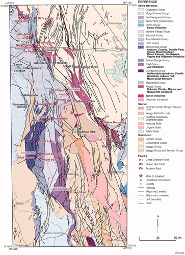
Siluro-Devonian volcanic rocks within the central Lachlan Orogen (CLO) are exposed in two parallel south-southeast–trending belts from just south of Cobar to just north of Albury (). For ease of discussion, we divide the volcanic successions into northern and southern successions (Supplemental data, Table S1). The Geological Survey of New South Wales has recently engaged in numerous mapping and mineral assessment projects within the CLO, the most recent of which includes the East Riverina Mapping Project involving regional mapping between West Wyalong and Albury (e.g. Campbell, Citation2017; Eastlake, Citation2020; Gilmore, Citation2015; Trigg, Citation2016). Volcanic successions within the southern CLO have been looked at as a part of the East Riverina Mapping Project and are the primary focus of this study. The southern successions include the Gurragong Volcanics and Walleroobie Volcanics, referred to herein as the Gurragong Group (see below; Tables S1 and S2), and previously unnamed volcanic rocks that crop out in the region (Adamson & Lowdon, Citation1966; Chappell et al., Citation1991; Tuckwell, Citation1976). We also identify new volcanic lithofacies that herein are collectively referred to as the Culcairn Group and include the Budginigi Ignimbrite and the Wallandoon Ignimbrite.
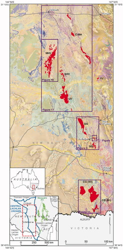
Figure 1. The central Lachlan Orogen volcanic belt highlighted in red overlain on GSNSW Seamless Geology (Colquhoun et al., Citation2019) and total magnetic intensity image, reduced to pole. Abbreviations: BI, Budginigi Ignimbrite; C-MH, Canbelego-Mineral Hill Belt, CG, Culcairn Group; GG, Gurragong Group; MHV, Mount Hope Volcanics; SHV, Shepherds Hill Volcanics; UV, Ural Volcanics; WI, Wallandoon Ignimbrite; YV, Yarnell Volcanics.
The northern volcanic successions of the CLO include volcanic sequences within the Canbelego-Mineral Hill Volcanic Belt (Kopyje Group), the Yarnel Volcanics (Ootha Group), the Mount Hope Volcanics (Mount Hope Group) and the Ural Volcanics (including the Shepherds Hill Volcanics; Rast Group; Table S1 and S2). Several volcanic sequences in the northern CLO, such as the Ural Volcanics and the Mount Hope Group, were initially interpreted to contain subaerial to shallow-water indicators (e.g. Pogson, Citation1967; Trigg, Citation1987). The presence of welding textures and airfall tuffs were used to support interpretations of widespread subaerial volcanism. However, focused volcanological studies have brought to light subaqueous features like quench textures, water-settled pumiceous facies, and interbedded sedimentary basin sequences (Bull, Citation2006; Bull & McPhie, Citation2006; Colquhoun et al., Citation2005; Simpson, Citation2015a, Citation2015b). The interpretation of a deep-marine (below storm-wave-base) depositional environment for these volcanic sequences, in conjunction with other data, has contributed to and confirmed the recognition of extensional backarc basins controlling Siluro-Devonian magmatism and related ore deposits (e.g. Cas, Citation1983; Downes et al., Citation2016; Fitzherbert et al., Citation2016; Glen et al., Citation1996).
Tectonic models of the Lachlan Orogen have predominantly focused on the deformation history of meta-sedimentary sequences (e.g. Chappell et al., Citation1988; Fergusson, Citation2017; Foster et al., Citation1999; Glen et al., Citation1996, Citation2012), but these models have under-utilised the depositional environment and chemical affinities of the Siluro-Devonian volcanic successions, as revealed by detailed facies mapping, to be important factors in unravelling the belt’s tectonic history. Similarly, the relationship of mineralisation to Lachlan Orogen volcanic successions has been poorly understood. Several ore-genesis models have been proposed within the tectonic framework of the CLO, and ideas have traditionally been split firmly between two camps—relatively local magmatic-related systems, or deep-fault transported metamorphic hydrothermal systems. Examples include Cu/Pb/Zn mineralisation of the Cobar Basin in the northern CLO, such as in situ, remobilised ca 420 Ma VMS, and intrusion-related systems (e.g. David, Citation2006; Edgecombe & Soininen, Citation2019); 415–400 Ma distal intrusion-related (including skarn; Fitzherbert et al., Citation2021) deposits; and 400–380 Ma inversion-related orogenic deposits (e.g. Lawrie & Hinman, Citation1998). In the southern CLO, where mineralised granites and volcanic facies are temporally and spatially related, the intrusion-related Sn–W systems have been relatively well constrained, although recent advancements in U–Pb dating of cassiterite have better defined the relationship between magmatism and mineralisation (e.g. Yuan et al., Citation2008; Zhang et al., Citation2017).
We present a more wholistic model for the evolution of the CLO directly relating temporal links between the volcanic successions of the southern and northern CLO, volcanic facies distribution over the entire CLO, basement character over the CLO and the well-defined cycles of orogenesis for the Lachlan Orogen to contextualise the newly defined volcanic successions, and facies in relation to recent tectonic and metallogenic reconstructions.
Images of outcrops or hand samples, and photomicrographs, are included with the respective site, sample or thin-section number. The locations and associated metadata of the sites, samples or thin-sections may be found online in GSNSW Seamless Geology (Colquhoun et al., Citation2019).
Volcanic successions of the southern CLO
Gurragong Group
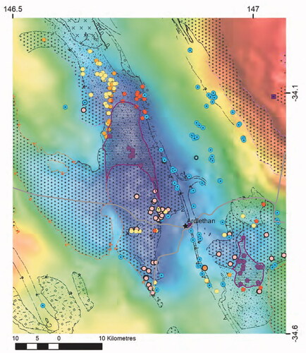
The Gurragong Volcanics, a formation initially described by Colquhoun et al. (Citation2005) west of West Wyalong, extends for almost 25 km to just south of Ardlethan (; Bull, Citation2015). Southeast of, but virtually continuous with the Gurragong Volcanics, volcanic rocks were identified and collectively named the Walleroobie Volcanics by Brunker and Offenberg (Citation1970) and briefly described by Warren et al. (Citation1995). Recent mapping increased the distribution of the volcanic succession, which crops out approximately 10 km north of Ardlethan, NSW and continues south-southeast for approximately 40 km (; Bull & Blevin, Citation2016; Campbell, Citation2016; Trigg, Citation2016). Outcrops vary in thickness across the extent of the unit from 3 to 140 m.
Detailed investigations by the Geological Survey of NSW (e.g. Bull, Citation2015; Bull & Blevin, Citation2016; Campbell, Citation2016; Trigg, Citation2016) and work described in this study indicate that the Walleroobie Volcanics are indistinguishable from the Gurragong Volcanics. We, therefore, have combined the two coeval and texturally and compositionally similar formations and elevated them to group level as the Gurragong Group, and that group is subdivided into four formations: Walleroobie Ignimbrite, Corella Ignimbrite, Indarra Tuff and Mount Ariah Rhyolite (; Table S2), all of which are summarised in Table S3 and briefly described below.
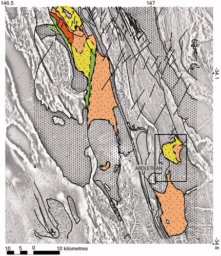
Figure 2. Gurragong Group, northwest to southeast of Ardlethan. Walleroobie Ignimbrite (orange), Corella Ignimbrite (red), Indarra Tuff (green), and felsic coherent units of the Mount Ariah Rhyolite (yellow) are highlighted. Units are drawn on an image combining the first vertical derivative of total magnetic intensity data, GSNSW Seamless Geology (Colquhoun et al., Citation2019). The rectangle indicates the location of .
Walleroobie Ignimbrite
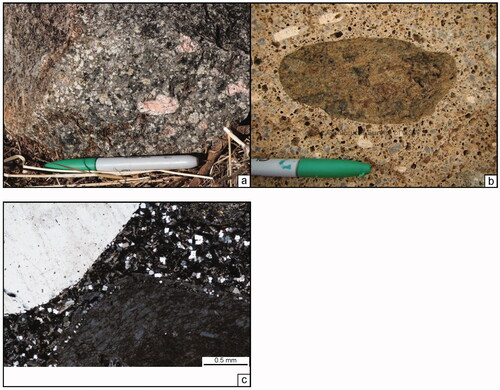
Characteristics of the Walleroobie Ignimbrite (Table S3) suggest that it represents a partially to densely welded crystal-rich pyroclastic density current deposit, or ignimbrite, that was emplaced in a subaerial environment. Evidence supporting this interpretation includes the presence of juvenile pyroclasts (crystals and pumice) (Fisher et al., Citation1993; Milner et al., Citation2003; Sparks et al., Citation1973), lithophysae and partial to dense welding textures. The crystals are generally fragmented, their abundances commonly >50%, and their size and spatial distributions are inconsistent. These characteristics are consistent with particulate concentration rather than representing phenocrysts in a formerly glassy groundmass (; Druitt, Citation1998; Scarpati et al., Citation2020).
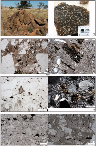
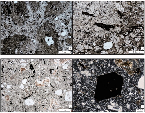
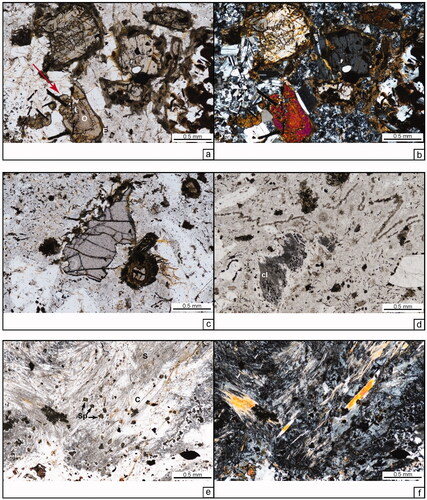
Figure 3. (a–d) Gurragong Group, Ardlethan area. (a) Rounded and jointed outcrop. Hammer handle is 50 cm. (b) Hand sample showing the crystal-rich texture of the unit. The spaced crystals and presence of pink feldspars make this unit appear similar to be a fine-grained porphyritic or sub-equigranular coherent rhyolite. (c) Photomicrograph showing the closely packed, angular and variable grainsize of the crystals. G, garnet; K, clay-altered K-feldspar; P, sericite-altered plagioclase. Plane-polarised light. Scale bar is 1 mm. (d) Photomicrograph showing welding. Densely welded formerly glass shards wrap around altered biotite and quartz crystals and crystal fragments. Plane-polarised light. Scale bar is 1 mm. (e–h) Walleroobie Ignimbrite, Ardlethan–Barmedman area. (e) Plane-polarised light image showing garnet (‘G’). Biotite, pale to dark brown, totals about 5%. Note the large size variation and the angular, broken morphology of most crystals. The speckled texture of the matrix is granoblastic recrystallisation, indicating the rock has been contact metamorphosed. The scale bar is 1 mm. Thin-section T089326. (f) The cross-polarised light image of a cordierite crystal (‘C’). The cordierite has tightly spaced parallel partings, typical of magmatic cordierite. Biotite and opaque (Fe-oxide) crystal clusters can be seen at either end of the cordierite. The matrix of the rock has a speckled granoblastic texture, typical of recrystallisation owing to contact metamorphism. Overgrowths, also owing to recrystallisation, can also be seen on the margins of the quartz and feldspar crystals. Cross-polarised light. Thin-section T089274. (g) A porphyritic pumice lens is visible in the centre of this plane light photomicrograph. Very fine-grained secondary biotite, a result of contact metamorphism, is disseminated throughout the image and delineates margins of the pumice lens. Recrystallisation in this sample has not been so advanced as to obliterate the clast completely, however. The scale bar is 1 mm. Thin-section T089274. (h) Pumiceous clasts with wispy terminations (upper-centre and lower left), and welding bands are visible in this unmetamorphosed sample. Note the wrapping textures around crystals and small lenses of the slightly coarser-grained recrystallised glassy matrix. The small lenses likely represent small pumice clasts or recrystallised glassy vugs, such as lithophysae. Such textures suggest dense welding. Thin-section T089854.
Pumice clasts are visible in non-metamorphosed exposures and tend to be plastically deformed, compacted, and ‘wispy’ in shape, suggesting hot emplacement and modification while still hot and malleable. The pumice is porphyritic to aphyric, reflecting similar phenocryst mineralogy as the crystals in the matrix. Furthermore, pumice clasts are indicators of explosive fragmentation when they are in the presence of other pyroclasts, and not associated with a vesicular margin of a lava or sill (Sparks et al., Citation1973; Wilson & Walker, Citation1982). Bubble-wall shards are by and large absent, except within an area east of Ardlethan where outcrops that contain partially welded bubble-wall shards can be found. In weakly metamorphosed examples, the groundmass exhibits banding and wrapping textures, devitrification textures and lithophysae after a volcanic glass (). In particulate and fragmental rocks, the (formerly) glassy matrix can only be produced by welding glassy particles such as shards. Where banding and lithophysae are present and shards remain, the welding must have been moderate to dense (Breitkreuz, Citation2013; Quane & Russell Citation2005; Streck & Grunder, Citation1995).
A variety of lithic clasts are locally present (≤5%) (Bull & Blevin, Citation2016; Campbell, Citation2016), which also implies a pyroclastic origin. The clast types include cognate clasts porphyritic and aphyric felsic coherent clasts that are similar in phenocryst size and mineralogy to the host volcaniclastic matrix. Such felsic volcanic rock fragments are interpreted to be from a similar source as the ignimbrite, like the vent or underlying coherent facies. Accidental granite and meta-sandstone fragments are also common. The granitic fragments are somewhat fluidal in shape and have indistinct margins, such as the aligned inclusions just north of Ardlethan (, ; Bull, Citation2015). These clasts appear to have been included in and in equilibrium with the melt. The meta-sandstone clasts are biotite-rich, schistose and weakly foliated, and ± sillimanite- and cordierite-bearing. Owing to their angular shapes, these clasts are interpreted to have been incorporated from the basement during transport of the pyroclastic density current. Where modal lithic clast content is >5%, the crystal-rich facies is correlated with the informal lithic ignimbrite unit (Dgsi) of Colquhoun et al. (Citation2005) and upgraded to Corella Ignimbrite (described below). A high concentration of these clasts likely represents the base of the ignimbrite (Walker, Citation1972; Wilson & Walker, Citation1982).
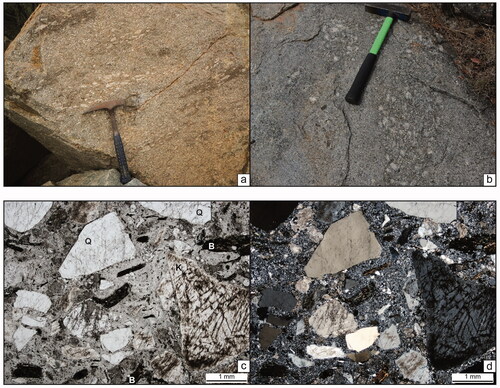
Figure 4. (a, b) Feldspar porphyritic granitic clasts within the Walleroobie Ignimbrite at Bolero Mountain, Gurragong Group. The clasts are phaneritic and granitic in composition. Note the alignment of the clasts within the ignimbrite and the somewhat diffuse margins of the clasts. Rock hammers for scale; approximately 30 cm long (a), 50 cm long (b). Site ERIVPJG0118. (c, d) Ardlethan Mine ‘garnet–quartz–feldspar porphyry’ (GQFP) unit. Paired images were taken under plane-polarised (c) and cross-polarised (d) light. Angular, broken and closely packed crystals of quartz (Q), perthitic and clay-altered K-feldspar (K), altered biotite (B) in a granoblastic, recrystallised matrix. Note the similarity in crystal abundance, distribution, species and morphology to the Walleroobie Ignimbrite images in , suggesting the GQFP is indistinguishable from the crystal-rich units found north and south of the mine. Scale bars are 1 mm. Thin-section PB-ARD-06.
A pyroclastic origin for the Walleroobie Ignimbrite is also suggested by the presence of banded, wrapping textures that reflect the heating, dense welding and rheomorphic flow of formerly glassy pyroclasts, and the presence of lithophysae and spherulites indicate crystallisation of dense glass. Although entire cooling units or large portions of pyroclastic density current deposits may not be welded, the presence of textures that indicate a formerly dense glassy matrix in a particulate, or clastic, rock cannot be explained other than by welding.
The majority of the Walleroobie Ignimbrite from north to southeast of Ardlethan exhibits evidence of secondary recrystallisation, including granoblastic texture and grainsize coarsening of the quartzo-feldspathic matrix (). These textures have not been described in crystal-rich ignimbrites elsewhere. Given the proximity of these rocks to younger intrusions, a sharp gradient to unrecrystallised Walleroobie Ignimbrite and a lack of foliation, these textures suggest the rocks have been contact metamorphosed. In many cases, the recrystallisation has obliterated any primary matrix textures such as welding, or formerly glassy fragments such as pumice clasts. A Bouguer gravity image over the area suggests a large intrusion underlying the majority of the Gurragong Group (). An exception is on either side of the Newell Highway, east of Ardlethan, where neither units of the Walleroobie Ignimbrite nor the Mount Ariah Rhyolite (see below) exhibit granoblastic textures. These textures are significant with respect to the unit’s relationship to the contemporaneous intrusions in the region, as discussed below.
Figure 5. Areas of contact metamorphism (horizontal striped polygons) within Walleroobie Ignimbrite, Ardlethan area. Polygons overlie the Lachlan Orogen layer of the NSW Seamless Geology (stippled patterns; V-stippled pattern is the Gurragong Group volcanic rocks; Colqhuhoun et al., 2019), and a Bouger gravity image. Coloured symbols represent samples with petrographic analysis: red polygons, Walleroobie Ignimbrite (WI); purple polygons, contact metamorphosed WI; orange polygons, Indarra Tuff; yellow polygons, Mount Ariah Rhyolite (yellow triangle, autobreccia); pink circles, granitic rocks; blue circles, Ordovician meta-sedimentary rocks; purple square, schist.
A previously described porphyritic intrusion at and around the Ardlethan Mine informally called the ‘garnet quartz–feldspar porphyry’ (GQFP) unit (Paterson, Citation1976; Ren, Citation1989), is indistinguishable from the Walleroobie Ignimbrite in the Gurragong Group () (Bull, Citation2015; Bull & Blevin, Citation2016; Trigg, Citation2016). The matrix exhibits granoblastic texture and includes very fine-grained secondary biotite, and overgrowths are present on quartz and feldspar crystals indicating the unit has been contact metamorphosed. Identification of the GQFP unit as an ignimbrite rather than a porphyritic intrusion precludes the unit as a source of mineralising fluids.
The Walleroobie Ignimbrite has recently yielded U–Pb (SHRIMP) dates from magmatic zircon (and monazite) in several locations (Bodorkos et al., Citation2013, Citation2018). East of the Yalgogrin Range the unit yielded a U–Pb magmatic zircon age of 415.4 ± 2.8 Ma (Bodorkos et al., Citation2018); just north of the Ardlethan Mine an ignimbrite sample was dated to be 416.5 ± 2.4 Ma; at the Ardlethan Mine, the GQFP unit yielded a date of 417.9 ± 2.3 Ma; and at Millbrae Quarry, south side of Walleroobie Road, the ignimbrite was dated to be 418.7 ± 1.8 Ma (Tables S1 and S4; Bodorkos et al., Citation2013).
Corella Ignimbrite
The Corella Ignimbrite is exposed east of Ardlethan, as well as west of West Wyalong where it was the informal lithic ignimbrite unit (Dsgi) within the Gurragong Volcanics (Colquhoun et al., Citation2005) (Tables S1–S3). The unit is a clast- and crystal-rich, variably welded volcaniclastic sandstone that we interpret to be lithic-clast-rich ignimbrite (Colquhoun et al., Citation2005; this study) (, ). These rocks are similar in composition and crystal content to the variably welded and pumice-bearing Walleroobie Ignimbrite and include crystals, pumice clasts and bubble-wall shards, but contain up to 40% angular accidental (or possibly accessory) lithic clasts. The lithic fragments in the unit west of West Wyalong include Ordovician quartzite and slate in addition to a variety of porphyritic and aphyric felsic volcanic clasts (Colquhoun et al., Citation2005). Within the unit east of Ardlethan, the lithic clasts are predominantly coherent rhyolite. The abundance of lithic clasts suggests the formation represents an initial, vent-clearing explosive deposit or the stratigraphically lowest in a succession that picked up underlying lava or other bedrock fragments during transport. The Corella Ignimbrite west of West Wyalong yielded a U–Pb SHRIMP magmatic age of 417.9 ± 2.3 Ma (Table S4; Black, Citation2005).
Figure 6. (a, b) Corella Ignimbrite. Clasts of finely flow-banded (a; arrows) and perlitic rhyolite (b) in clast- and crystal-rich ignimbrite, east of Ardlethan. Thin-sections T090134, T090139. (c, d) Mirrool rhyolite. (c) The plane-polarised light image of the Mirrool rhyolite. Note K-feldspar (K), partially altered to brown clay, garnet (G) and opaque-altered ferromagnesian minerals (now Fe-oxide minerals). The scale bar is 1 mm. Thin-section T089358. (d) Cross-polarised light image of an amphibole pseudomorph now comprising opaques, likely a combination of magnetite and ilmenite. Note the titanite (T), a common secondary mineral after ilmenite. Thin-section T089358.
Mount Ariah Rhyolite
Felsic coherent facies and associated autoclastic breccias within the Gurragong Group are collectively referred to as the Mount Ariah Rhyolite () and are characterised by porphyritic texture and similar phenocryst types and abundances. Phenocrysts include high modal quartz, lesser feldspar and biotite, and, commonly, trace amounts of primary garnet (Table S3). Additional phenocryst phases differ between the coherent units and may include cordierite, orthopyroxene or clinopyroxene. Accessory minerals (trace–2%) include fluorite, muscovite, zircon, and opaque minerals (predominantly non-magnetic). The groundmass in the felsic coherent units is generally a recrystallised mosaic of quartzo-feldspathic granophyric texture, locally perlitic and/or containing spherulites. Flow banding is common in the coherent facies, now defined by contrasting alteration products (e.g. bands of chlorite or iron oxide vs albite; or sericite + clay vs granophyric-textured recrystallised glass), probably after original variations in composition or spherulite contents that separated during laminar flow. Geochemical analyses indicate the coherent units are predominantly rhyolites (see geochemical data below). Irregular quartz veinlets containing fluorite uncommonly occur in the felsic units.
Poor exposure makes it impossible to map most contacts and to estimate the size of each unit or body, but coherent rhyolite forms most exposures in the Yalgogrin Ranges north and select hills east of Ardlethan. There is substantial variability between felsic coherent units in terms of their geophysical signature and mineralogy. The coherent units east of Ardlethan are magnetite-bearing and anomalously high on aeromagnetic imagery (). In contrast, the Rowallen rhyodacite exposed just approximately 5 km to the southwest of the above coherent units contains fibrolite + spinel clasts, is magnetite-poor and overlies relatively weak total magnetic intensity (see below).
Figure 7. Mount Ariah Rhyolite ∼12 km east of Ardlethan (see ). Individual coherent rhyolites are distinguished by their mineralogy, texture and magnetic qualities as shown on this greyscale total magnetic intensity image, with tilt-filter applied; white represents relatively high magnetic intensity. Yellow is Mount Ariah Rhyolite (MAR), pink is Walleroobie Ignimbrite (WI). Darker pink on the south edge of the image is contact-metamorphosed WI (hf). Field sites are small grey circles.
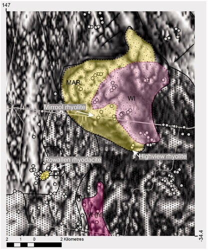
Three examples of distinct coherent units include informal units referred to as the Mirrool rhyolite, Highview rhyolite, and Rowallen rhyodacite (), and are described below.
Mirrool rhyolite
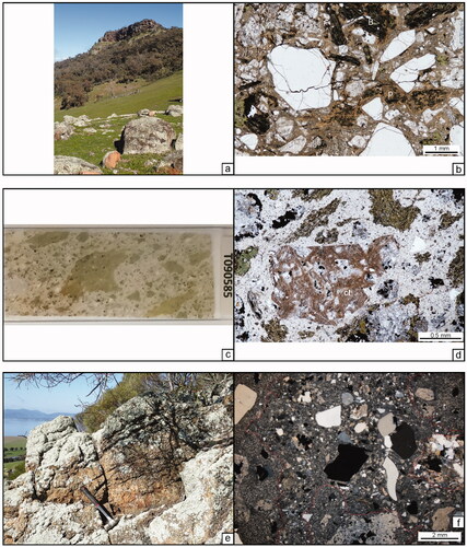
Exposed in a roadside rest area east of Ardlethan, near Beckom, the Mirrool rhyolite crops out as blasted boulders and small exposures (Bodorkos et al., Citation2016). The unit is porphyritic, including phenocrysts of up to 3 mm-diameter of quartz, plagioclase, K-feldspar, altered ferromagnesian minerals, and garnet ( and ). Garnet totals <1%, is anhedral, fractured and rimmed by plagioclase. Apatite is commonly associated as inclusions or adjacent to many ferromagnesian phenocrysts and is present as long needles in the groundmass.
The ferromagnesian minerals in the Mirrool rhyolite are quite distinctive, ranging in size from 0.1 to 1 mm and, although generally replaced by opaque minerals (ilmenite ± magnetite), they have morphologies ranging from diamond- to acicular- and prismatic-shaped crystals. This suggests that at least some of the crystals may have been amphibole, and some of the prismatic-shaped phenocrysts may have been biotite. Titanite is visible in places as an alteration phase, indicating the primary phases were titanium-rich, and the rock has an extremely high magnetic susceptibility (∼1690 × 10−5 SI). The exposed rhyolite is on the southern end of a distinct magnetic anomaly ().
Highview rhyolite
The Highview rhyolite crops out approximately 3 km southeast of the Mirrool rhyolite and at the southern end of the magnetic anomaly that is associated with the Mirrool rhyolite ( and ). Despite their proximity, the units differ in several ways. Most significantly, amphibole phenocrysts are absent in the Highview unit (). In addition, the groundmass consists of relatively coarse-grained quartzo-feldspathic symplectite textures. Garnet phenocrysts contain multiple quartz inclusions (and are almost completely altered to biotite and chlorite). K-feldspar is present, although in sparse abundance (∼1%), consistent with whole-rock chemical data indicating the unit is low-silica rhyolite.
Figure 8. Highview rhyolite. (a) The plane-polarised light image of quartz, plagioclase (P; zoned and sericite-altered), chlorite ± opaque-altered biotite (B), and very fine-grained opaques. Note the relatively coarse quartzo-feldspathic symplectite recrystallisation, devitrification textures of the formerly glassy groundmass. The scale bar is 1 mm. Thin-section T089855. (b) Former garnet phenocryst with abundant quartz inclusions that are almost completely replaced by biotite and chlorite. Remnant garnet fragments are pinkish and high-relief in plane-polarised light. The scale bar is 1 mm. Thin-section T089855. (c) Quartz crystal surrounded by secondary biotite in a groundmass of quartzo-feldspathic symplectite recrystallisation textures. Fine-grained biotite is also in the groundmass. The scale bar is 0.1 mm. Thin-section T089855.
Rowallen rhyodacite
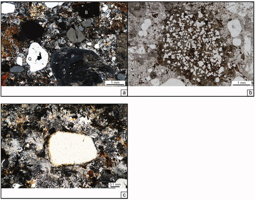
A distinctive felsic coherent unit that crops out southwest of the Mirrool rhyolite ( and ), the Rowallen rhyodacite contains phenocrysts of 5% quartz, 5–7% plagioclase, 3–7% orthopyroxene, 1–2% biotite (some quite red), 2–3% garnet, and 5–7% of a needle-shaped, slightly purplish opaque mineral interpreted to be ilmenite. K-feldspar is absent suggesting rhyodacite (low-silica rhyolite) composition. Orthopyroxene is also locally associated with fine-grained plagioclase–ilmenite glomerophyric clusters, and here displays no edenite reaction rims in contact with the plagioclase–ilmenite (, ). In most cases, garnet is rimmed by plagioclase (albite?), although in one thin-section garnet is adjacent to and in textural equilibrium with orthopyroxene. Plagioclase crystals are zoned, and commonly resorbed.
Figure 9. Rowallen rhyodacite. (a, b) Paired images were taken under plane-polarised (a) and cross-polarised (b) light of orthopyroxene phenocrysts (O). In (a), note the pink centre vs green rim pleochroism of the labelled phenocryst. Also note the dark green, fine-grained fibrous edenite (E) reaction rims on the margins of each orthopyroxene crystal. The prismatic opaque minerals are likely ilmenite. Note the lack of edenite reaction rim where orthopyroxene contacts plagioclase + biotite (arrow); the phenocrysts appear to be in equilibrium with the clusters, but not with the melt. The scale bar is 0.5 mm. Thin-section T089285. (c) The plane-polarised light image of garnet phenocryst. Note the reaction rim on the left side of the crystal comprising plagioclase, chlorite and very fine-grained biotite. Also, note the biotite and edenite rims around the orthopyroxene phenocryst on the right side of the garnet. The scale bar is 0.5 mm. Thin-section T089285. (d) Tightly folded flow banding is visible across the upper part of this plane-polarised image. Note the feathery sillimanite-rich clast rimmed by plagioclase (cl). The scale bar is 0.5 mm. Thin-section T089745. (e, f) Closer view in-plane- (e) and cross-polarised light (f) of meta-pelitic lithic clast visible in (d). Acicular fibrolite (sillimanite; S) crystals are intergrown with cordierite (C), and green/opaque spinel crystals (Sp). The scale bar is 0.5 mm. Thin-section T089745.
In addition to the phenocrysts, the rhyolite contains wispy and somewhat fluidal clasts of meta-sedimentary rock comprising biotite, fibrolite, green spinel, and cordierite (locally altered to pinite) (). Sinusoidal bands resembling a kind of flow-band or rheomorphic flow are near meta-pelitic clast margins, and the groundmass contains quartzo-feldspathic micropoikilitic and granophyric recrystallisation textures.
Ages yielded from felsic coherent units in the Mount Ariah Rhyolite overlap with each other. Rhyolite from the Yalgogrin Ranges north of Ardlethan yielded a U–Pb SHRIMP zircon age of 419.0 ± 2.8 Ma; the rhyolite near Mirrool was dated at 418.3 ± 2.3 Ma; and a rhyolite autobreccia yielded an age of 418.1 ± 2.0 (Bodorkos et al., Citation2016, Citation2018) (Table S4). A U–Pb SHRIMP zircon age of 418.3 ± 2.3 was obtained from the previously informal garnet granite (Dsgg) unit within the Gurragong Volcanics (Black, Citation2005; Colquhoun et al., Citation2005).
Indarra Tuff
Indarra Tuff is a volumetrically minor facies that overlies coherent units 30–40 km north-northwest of Ardlethan (). The unit is non- to densely welded, pumice- and shard-bearing, crystal-poor to moderately crystal-rich, coherent rhyolite, volcaniclastic sandstone ( and ). On Kangaroo Hill, about 60 km north-northwest of Ardlethan (MGA Z55 475765.0 E, 6221820.7 N), the volcaniclastic sandstone drapes and infills between clasts in rhyolite autobreccia.
Figure 10. Indarra Tuff. (a) Well-foliated ‘tombstone’ outcrops, Kangaroo Hill (MGA Z55 475765.0 E, 6221820.7 N). Photograph by P. J. Gilmore. (b) Wetted outcrop surface at Islay Quarry, south of the Yalgogrin Ranges, northwest of Ardlethan. Aphyric and porphyritic rhyolite lithic clasts are visible, as are crystals and former pumice clasts. (c) Photomicrograph of shard-rich volcaniclastic sandstone. Note the slightly rounded and wrapping forms of the originally sharp, cuspate, and arcuate bubble-wall shards, indicating annealing and partial welding. The scale bar is 0.5 mm long. (d) Sample of sintered and deformed (welded) bubble-wall shards and broken crystals from the Indarra Tuff west of West Wyalong. Thin-section T071802; plane light; scale bar is 0.1 mm.
Crystals within the unit consist of 0.2–2 mm angular and broken quartz, feldspar, and trace to ∼3% biotite. Quartz crystals are commonly embayed, and alkali feldspars locally exhibit microcline twinning (and altered to clay ± sericite). Biotite is common (altered to chlorite and opaque minerals), and the formerly glassy groundmass is recrystallised, but subsequently altered to clay, ± sericite and zeolites. The sandstone also contains sparse clasts of porphyritic or aphyric rhyolite.
Bubble-wall shards vary from somewhat annealed (sintered or partially welded) to being densely welded (). Units are massive or may exhibit rare compaction laminations or bedding. A tectonic cleavage is variably detectible in these units, the best example of which is from atop Kangaroo Hill, where the rock exposures display steeply dipping foliation and have formed a series of ‘tombstone’ outcrops ().
Gurragong Group correlations
Mount Ariah Rhyolite unit ages correlate with those of the Walleroobie Ignimbrite and Corella Ignimbrite, suggesting they are contemporaneous (Table S4). The Mount Ariah felsic coherent units are also coeval with the garnet granite of Colquhoun et al. (Citation2005). However, the garnet granite is interpreted to be a granitic intrusion, and we propose it to be separated from the Gurragong Group and named the Schillers Lane Granite.
Culcairn Group
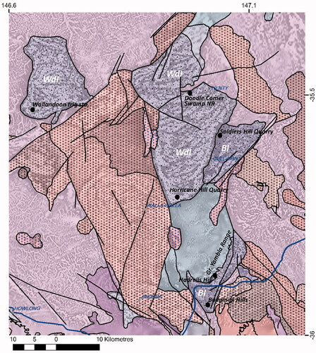
Approximately 100 km south of the Gurragong Group (), volcanic rocks were recognised by previous workers (Adamson & Lowdon, Citation1966; Chappell et al., Citation1991; Degeling, Citation1977; Hall & Whiting, Citation1957), but left undifferentiated and undescribed. Based on geographical separation and compositional differences described below, we propose these coeval volcanic successions be divided into two formations, the Budginigi Ignimbrite and the Wallandoon Ignimbrite, together making up the Culcairn Group ().
Figure 11. Culcairn Group (see for location). Budginigi Ignimbrite (BI) and Wallandoon Ignimbrite (WdI) are in violet. The majority of BI is a crystal-rich ignimbrite and includes the minor hyaloclastite pumice breccia Hadrells Hill Member at Hadrells Hill, and the Soldiers Quarry Member, a K-feldspar porphyritic coherent rhyolite east of and including Soldiers Hill Quarry. Stippled patterns are from NSW Seamless Geology (Colquhoun et al., Citation2019), the background is grey-scaled total magnetic intensity image, reduced to pole. Other coloured units are predominantly intrusions and are described in detail in Bull (Citation2017).
Budginigi Ignimbrite
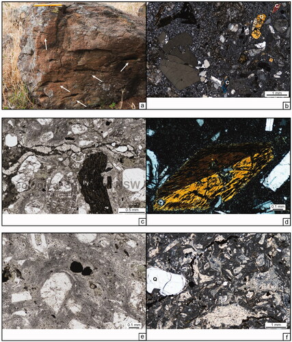
The Budginigi Ignimbrite is a felsic package of predominantly volcaniclastic lithofacies (including the Hadrells Hill Member) and minor coherent facies (Soldiers Quarry Member) that crop out in two areas: the northern exposures mapped surrounding and north of Culcairn, and the southern exposures that lie along the east side of the Great Yambla Range and south to Big and Little Budginigi hills () (Bull, Citation2017). Coherent facies are limited to the Soldiers Quarry Member rhyolite north of Culcairn.
North of Budginigi hills, and east and south of the northeast-trending Great Yambla Range, two volcaniclastic facies were recognised below an unconformity that separates them from probable Upper Devonian conglomerate and sandstone red beds (Adamson & Lowdon, Citation1966; Bull, Citation2017). The predominant facies, the Budginigi Ignimbrite, consists of a crystal-rich, pumice-bearing volcaniclastic sandstone that is exposed from the Great Yambla Ranges foothills to the east to where it contacts the Yellow Creek Granite, Mullengandra Monzodiorite and the Koetong Granite (; Bull, Citation2017). The unit contains 45–50%, 0.5–7 mm crystals that include euhedral and fragmented quartz, clay- and sericite-altered feldspar, biotite, garnet and possible cordierite. Lithic clasts are both aphyric and quartz–feldspar ± biotite-phyric. Also within the unit are chlorite-altered, wispy compacted former vitriclasts, which we interpret to be former pumice clasts. Wrapping welding bands and discontinuous, attenuated recrystallised (microspherulitic) bands are suggestive of welding, and lithophysae are also visible in some samples. The high crystal density, welding bands and former vitriclasts suggest this unit is a welded ignimbrite.
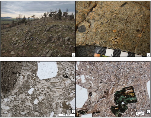
Figure 12. Budginigi Ignimbrite southeast of the Great Yambla Range. (a) Crystal-rich ignimbrite in the foreground and Upper Devonian red beds in the background. The unconformity lies approximately across the middle of the image. Site ERIVKFB0303a. (b) Photomicrograph of crystal-rich, pumice-bearing ignimbrite. Fluidal-shaped, chloritic clast in centre is a pumice clast (p). Chlorite-altered biotite (B) are at the top of the image. Thin-section T090580. (c) An image taken of thin-section T090585 shows the curvilinear margins to the chloritic clasts, suggesting they are quench-fragmented formerly glassy clasts. The thin-section is 2.5 cm wide (vertical image dimension). (d) The plane light image of hyaloclastite breccia with Fe-oxide-altered welded crystal ignimbrite clast (cl). Chloritic fragments have curvilinear margins indicating they have been quench-fragmented. Porphyritic clasts are visible at the bottom and left sides of the image, and crystals are also present in the matrix. Thin-section T090585. (e, f) Budginigi Ignimbrite at Budginigi hills. (e) Shallow-dipping joints in the ignimbrite likely reflect bedding. Hammer is ∼50 cm long. Site ERIVKFB0282b. (f) Budginigi Ignimbrite in cross-polarised light. Porphyritic rhyolite clasts are outlined in red lines; matrix crystals of quartz, feldspar, biotite and opaque minerals are angular and poorly sorted. The scale bar is 2 mm. Thin-section ERIVLMC0271_1X_2_XP.
Budginigi Ignimbrite on the east side of the Great Yambla Range was dated from U–Pb SHRIMP analysis of magmatic zircons to be 413.6 ± 2.2 Ma (Table S1; Bodorkos et al., Citation2021). The unit at Budginigi Hill was dated from U–Pb analyses of both zircon and monazite to be 415.0 ± 2.3 and 412.8 ± 3.5 Ma, respectively (Bodorkos et al., Citation2016).
A volumetrically minor volcaniclastic facies within the Budginigi Ignimbrite that directly underlies the unconformity on Hadrells Hill () is a crystal-rich, lithic-clast-bearing, pumice breccia that is up to ∼5 m thick. On the south side of the hill, the unit contains up to 60% porphyritic and possibly spherulitic, chloritised clasts, from 0.1 mm to several centimetres in size that have curviplanar margins (, ). The cuspate clasts are indicative of quench fragmentation, suggesting the deposition of a felsic coherent unit into a subaqueous environment. Many clasts are aligned and may reflect alteration after a compaction fabric and/or primary bedding. One clast captured in the thin-section is a reddish, Fe-oxide-altered crystal ignimbrite clast, which may represent a fragment of the underlying crystal-rich ignimbrite previously described ().
The Soldiers Quarry Member is a K-feldspar megacrystic, biotite-bearing porphyritic coherent rhyolite to rhyodacite (low-silica rhyolite) that we interpret to be a high-level, subvolcanic intrusion or a thick lava-flow or lava-dome deposit (). Phenocrysts are evenly distributed and total approximately 35%. Trace amounts of angular to rounded 2–6 cm biotite to chlorite-rich mafic lithic inclusions also occur within the rhyolite (). The groundmass of the rhyolite exhibits a recrystallised, granoblastic texture (), and there is also abundant fine-grained chlorite, appearing to be alteration after secondary biotite. The granoblastic texture and occurrence of secondary biotite, in conjunction with overgrowths on phenocrysts, suggest the unit has been contact metamorphosed. The granoblastic texture in the groundmass of this rhyolite masks the primary crystallisation texture and creates a crystal-rich volcaniclastic appearance. However, the crystal distribution and contact relationships suggest a coherent body such as a high-level intrusion lava dome or thick lava-flow deposit. The Soldiers Quarry Member is similar in texture and composition to the Nyora Granite (Chappell et al., Citation1991; Colquhoun et al., Citation2005). Results from U–Pb SHRIMP zircon analyses of the Soldiers Quarry Member give an age of 413.7 ± 1.7 Ma (Table S1; Bodorkos et al., Citation2021).
Figure 13. Soldiers Quarry Member. (a) Rapikivi textured K-feldspar (pink core, rimmed by white feldspar) in crystal-rich coherent rhyolite. The pen is 14 cm long. Site ERIVKFB0186b. (b) Rounded biotite-rich (±chlorite) clast/inclusion. The pen cap is 4 cm long. Site ERIVKFB0213c. (c) Overgrowth on K-feldspar crystal and granoblastic texture in groundmass is likely due to contact metamorphism. Thin-section T090088.
Wallandoon Ignimbrite
Northwest of Albury and west of the Budginigi Ignimbrite, the Wallandoon Ignimbrite is exposed at the Wallandoon Trig site, Hurricane Hill Quarry and north of Doodle Comer Swamp Nature Reserve (). The unit includes pumice-rich and pumice-poor facies; both are amphibole-bearing, crystal-rich, and are local with and without clear welding textures (; Bull, Citation2017). On Wallandoon Hill, underlying the trig site, the unit contains approximately 5–7% wispy, compacted pumice clasts ranging from 2–15 cm long to 3–5 mm thick. Weathered surfaces on outcrops show the alignment of the compacted pumice clasts ().
Figure 14. Wallandoon Ignimbrite, pumice-rich facies. (a) Weathered outcrop showing preferentially eroded flattened pumice clasts (white arrows) to 15 cm long. Pen-magnet is 12 cm long. Site ERIVKFB0141c. (b) The left half of the image is a porphyritic rhyolite clast, right half is the host crystal-rich ignimbrite. Matrix ferromagnesian crystals include orthopyroxene (O) and clinopyroxene (C). Thin-section T090193. (c) Fluidal and wispy porphyritic pumice clast (p), and crystals (∼50%) in clay-altered matrix with welding bands. Note kinked pyroxene crystal (Py) with the end slightly wrapped by fluidal pumice clast. Thin-section T089890. (d). Euhedral amphibole crystal in cross-polarised light. Thin-section T090071. (e) Despite the clay alteration of the matrix, bands wrapping crystals visible in this image suggest the unit has been welded. Thin-section T089890. (f) Facies north of Doodle Comer Swamp Nature Reserve. This unit is extremely sericite-altered, but quartz crystals (Q) and wispy to angular fragments are visible.
The pumice-rich facies is composed of about 50% crystals of quartz, K-feldspar, plagioclase, clinopyroxene, orthopyroxene and hornblende. Pumice clasts are more intensely altered (chlorite–carbonate–epidote) than the ferromagnesian minerals or matrix. Lithic clasts total some 2–5% and comprise quartz–feldspar–amphibole porphyritic coherent rhyolite to rhyodacite. The matrix of the pumice breccia consists of clay-altered, devitrified and recrystallised glass and, locally, welding bands wrap around crystals ().
The Wallandoon Ignimbrite at and around Hurricane Hill Quarry has fewer pumice clasts and is more altered than at Wallandoon Hill. The unit is made up of about half crystals (45–50%), and contains clasts of possible granite and a dark, aphyric unit. Crystals are medium-grained (1–3 mm) and include approximately 10% quartz, 20% plagioclase and K-feldspar, minor biotite and chlorite-altered amphibole, clinopyroxene and orthopyroxene. The rock also contains trace to 2% disseminated pyrite (±pyrrhotite) and is magnetic. Welding bands that wrap crystals are visible.
The abundance of crystals and the presence of pumice clasts and welding bands suggest that the unit is an ignimbrite. Flattened and aligned pumice clasts suggest the unit underwent compaction prior to lithification. A preliminary U–Pb SHRIMP date from magmatic zircon in the Wallandoon Ignimbrite on Wallandoon Hill yielded a date of 412.6 ± 2.5 Ma (Table S1; Bodorkos et al., Citation2021).
Southern CLO geochemistry
Southern volcanic successions: Gurragong and Culcairn groups
Geochemical data of southern volcanic successions of the CLO include analyses from the Gurragong and Culcairn groups (Bull, Citation2015, Citation2017; Bull & Blevin, Citation2016). The data are presented in , grouped by geological unit and by facies (coherent vs volcaniclastic). A sample was deemed too altered to include for classification if it contained <2 or >5 wt% Na2O and >5 wt% K2O (n = 1 sample) after criteria from Large et al. (Citation2001) for calc-alkaline rocks. Samples of volcaniclastic facies within this dataset are interpreted to be ignimbrites and thus represent syn-eruptive deposits. However, the loss of the small glassy fraction during explosive eruptions is problematic in interpreting ignimbrite geochemical data. Ancient successions are particularly difficult, since any elutriate fraction is not easily identified. Nonetheless, we have utilised the data and plotted them with the results from the coherent rocks for comparison and characterisation.
Figure 15. Plots of geochemical data of southern CLO volcanic rocks, were obtained during the East Riverina Mapping Project. Explanation of symbols is at the top. Abbreviations: ASI, Alumina Saturation Index; ME, moderately evolved; MO, moderately oxidised; MR, moderately reduced; SE, strongly evolved; SO, strongly oxidised; SR, strongly reduced; VSO, very strongly oxidised. Log(Fe2O3/FeO), and K/Rb plots modified after Blevin (Citation2004). Compositional diagram Nb/Y vs SiO2 after Winchester and Floyd (Citation1977) shows felsic lithologies of the Gurragong Group (Mount Ariah Rhyolite and Walleroobie Ignimbrite). Wallandoon Ignimbrite samples are intermediate in composition.

A compositional discrimination diagram of SiO2 vs Nb/Y, modified after Winchester and Floyd (Citation1977), confirms the majority of volcanic units are rhyolites or rhyodacites, owing to the high modal quartz contents (). However, the amphibole-bearing Wallandoon Ignimbrite samples that contain 3–5% modal quartz plot as intermediate rocks and contain <65 wt% SiO2. Intermediate to mafic whole-rock compositions are uncommon in the volcanic rocks that stretch from Mount Hope to Albury (Bull, Citation2015; Bull & Blevin, Citation2016; Bull & McPhie, Citation2006; Simpson, Citation2014). The remaining samples form moderately consistent fractionation trends with respect to most elements.
Most southern CLO volcanic rocks are weakly to moderately peraluminous; the amphibole-bearing Wallandoon Ignimbrite is unsurprisingly the only metaluminous unit sampled (). Trace elements such as Ba, Th and Y plotted against SiO2 confirm that the Wallandoon samples do not represent a parent magma to the more felsic volcanic rocks and have a different source. also shows the Gurragong and Culcairn groups volcanic rocks to be strongly evolved, and moderately reduced to strongly oxidised. The sharp decrease in K/Rb at the highest SiO2 values suggests late K-feldspar fractionation (Blevin, Citation2004).
The compositional contrast between the metaluminous Wallandoon Ignimbrite and the peraluminous Walleroobie and Budginigi ignimbrites may be similarly reflected in the variation in coherent compositions within units of the Mount Ariah Rhyolite and between the coherent and ignimbrite facies. The far less abundant effusive facies are somewhat enigmatic, particularly within the Gurragong Group, reflecting heterogeneous melts and, possibly, sources. Unstable and completely replaced amphibole phenocrysts in the Mirrool rhyolite suggest an initial I- or A-type melt that perhaps tapped an S-type granitic source and changed chemistry with evolving conditions. The Rowallen rhyodacite, in contrast, appears to be a collection of restite clasts and crystals in a hot melt, reflecting the melting of meta-pelites. One would expect the crust and thus the melt-sources to be somewhat heterogeneous, but the proximity of such varying effusive products is interesting, especially considering the consistent S-type coherent facies farther north in the Gurragong Group (Bull, Citation2015; Colquhoun et al., Citation2005). A more rigorous look at the geochemistry of these successions is certainly warranted but beyond the scope of this study.
Volcanic lithologies, northern CLO
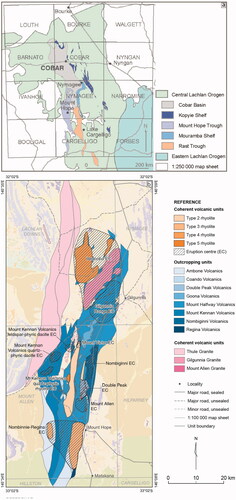
The northern CLO volcanic successions are of particular interest and significance owing to their association with ore deposits within the Cobar Basin. Three broad zones of volcanic rocks are present and include, from east to west, the Canbelego-Mineral Hill Volcanic Belt (including parts of the Kopyje and Ootha groups), the Ural Volcanics (part of the Rast Group) and the volcanic dominant Mount Hope Group (; Table S1). Several small rhyolite sills or domes are also present within the deep-water sedimentary sequences of the Cobar Basin. The lower sequences of the Cobar Basin are also intruded by dykes/sills that have exploited major fault systems late in the basin rifting event. Several syn- and post-volcanic granitic intrusions locally intrude the volcanic and correlative/host sedimentary sequences, with the exception of the deep-water Cobar Basin sequences. Lithologies and available interpretations of the data and/or classification of the volcanic successions are summarised below.
Volcanic rocks of the Kopyje and southernmost Ootha groups form the Canbelego-Mineral Hill Volcanic Belt along the present-day northeastern margin of the Cobar Basin (; Fitzherbert et al., Citation2016; Suppel & Gilligan, Citation1993). The main volcanic units of the Kopyje Group have been subdivided, from north to south, into the Florida, Babinda, Majuba, Mineral Hill and Yarnel volcanics (Ootha Group), with several smaller volcanic lithologies interfingering with Kopyje Group sedimentary packages (Table S1; Felton et al., Citation1985; Geological Survey of New South Wales, Citation1985; MacRae, Citation1988; Pogson, Citation1991). The sedimentary packages that host or are interbedded with the Kopyje and Ootha group volcanics include, from north to south; Meryula Formation, Baledmund Formation, Mount Knobby Formation, Talingaboolba Formation and Mulguthrie Formation (Ootha Group). These sedimentary packages contain volcanic, biogenic and basement derived detritus, as well as rare in situ limestones (e.g. Rookery and White Tank limestones in the Meryula Formation, Boomerang Tank Limestone Member, Beloura Tank Limestone Member and unnamed limestone intersected in drill core beneath the Florida Volcanics (Fromager & Granger, Citation1975) in the Baledmund Formation) and was deposited in a shallow-marine environment (Felton, Citation1981). Simpson (Citation2015a) interpreted the main volcanic packages of the Kopyje Group as extensive submarine lava–sill complexes that range compositionally from dacite to rhyolite, and have associated autoclastic breccias, many of which are hyaloclastites (quench-fragmented breccia). Explosive volcanic deposits are also present and range from coarse- to very fine-grained volcaniclastic deposits. The location and nature of volcanic centres are undetermined, but textural evidence and facies relationships suggest the volcanogenic parts of the Baledmund Formation, Talingaboolba Formation and Yarnel Volcanics are deposited indicative of distal and/or waning volcanism. Such observations are consistent with these sequences being deposits in moderate to shallow (basin-margin) water, the eruption centres having been shallow subaqueous or coastal subaerial (Felton, Citation1981; Simpson, Citation2015a; Suppel & Gilligan, Citation1993).
Figure 16. Volcanic successions of the northern central Lachlan Orogen. Volcanic sequences are in brightened colours on the map and in bold labels in the reference. Modified after Fitzherbert et al. (Citation2016).
Volcanic facies mapping and petrographic studies of the Mount Hope and Ural volcanic successions support models that indicate deposition to have been located within relatively small, narrow marine troughs (termed the Mount Hope and Rast troughs), which are part of the greater Cobar Superbasin (; Table S1; Bull, Citation2006; Bull & McPhie, Citation2006; David, Citation2006; David & Glen, Citation2004; Glen et al., Citation1996; Pogson, Citation1967; Scheibner, Citation1987; Simpson, Citation2015b; Trigg, Citation1987; Walshe et al., Citation1995). The Ural Volcanics comprise felsic lava–sill complexes and minor submarine pyroclastic facies constructed over a 100 km north–south trend (Bull & McPhie, Citation2006; Colquhoun et al., Citation2005). Zircon U–Pb (SHRIMP) ages from the Ural Volcanics suggest submarine volcanism occurred between 413 and 412 Ma (Colquhoun et al., Citation2005; Downes et al., Citation2016). Younger magmatic U–Pb ages of about 409 Ma were obtained from zircons by Bull et al. (Citation2008) using LA-ICP-MS, although larger uncertainties mean they fall within error of the SHRIMP ages. Older magmatic U–Pb ages from zircon obtained for the Ural Volcanics include 421 ± 2 Ma (LA-ICPMS, Bull et al., Citation2008), ca 420 Ma (preliminary, Bodorkos et al., unpub. data) and ca 425 Ma (Colquhoun et al., Citation2005), although the latter was suggested to be compromised by inherited zircon (Table S1).
Figure 17. (a) Simplified location map of the major depocentres in the northern CLO, showing the Cobar Basin and Mount Hope and Rast troughs. Modified after Downes et al. (Citation2016). (b) Mount Hope Group volcanic rocks and possible eruption centres (EC), modified after Simpson (Citation2015b). Background geology is from Colquhoun et al. (Citation2019).
Reconstruction of the evolution of the Ural Volcanics through a facies architecture study (Bull, Citation2006; Bull & McPhie, Citation2006) suggests that at least two eruptive centres produced a predominantly felsic sequence onto quartz turbidites and metamudstones of the Crossleys Tank Formation. Although both centres erupted coherent units (lavas and sills), one also erupted explosively, delivering pyroclastic products directly into the water via the eruption column and via high-particle concentration gravity currents. Subvolcanic dacite intruded the volcanic pile late in the evolution of the succession. Identification of fossiliferous limestone interbedded with volcanic facies on the southern end of the Ural Ranges, and jasper-bearing black siltstone in the central depo-area also indicate deep-marine deposition, possibly shallowing to the south (Bull & McPhie, Citation2006; Colquhoun et al., Citation2005).
The Mount Hope Group volcanic sequences are separated from the Rast Group by shallow-water shelf sequences of the Walters Range Group and are described as relatively deep-water subaqueous dacite to rhyolite lavas and sills, primary explosive and reworked volcaniclastic deposits, and minor intermediate to mafic dykes and sills (Bull & McPhie, Citation2006; Pogson, Citation1967; Scheibner, Citation1987; Simpson, Citation2015b; Trigg, Citation1987). Zircon U–Pb (SHRIMP) ages from several coherent volcanic units within the Mount Hope Group suggest that submarine volcanism occurred between 423 and 419 Ma (Downes et al., Citation2016). Simpson (Citation2015b) proposed multiple eruption centres produced a complex interbedded sequence of coherent and volcaniclastic facies that make up the Mount Hope Group (). Shale/siltstone-rich sedimentary packages present in the central-western parts of the trough (e.g. Wagga Tank and Blue Mountain) are interbedded with thick mass flow deposits rich in volcanic and subordinate fossiliferous limestone clasts (Edgecombe & Soininen, Citation2019). At Blue Mountain prospect, drill core (Allan, Citation1993) logged as a part of this study intersected coherent volcanic rocks intercalated with fossiliferous limestone and micritic, potentially lagoonal mudstone. The juxtaposition of the allochthonous and reef sedimentary facies suggests complex topography/bathymetry within the trough, potentially with atoll-like reef systems developed over emergent volcanic edifices within a predominantly moderate to deep-water trough. The western margin of the trough is faulted against a basement high that hosts Pragian to early Emsian (ca 410–406 Ma) shallow-water sequences of the Winduck Shelf (Mathieson et al., Citation2016).
Several contemporaneous granites intrude the volcanic troughs. In the Mount Hope Trough these include the S-type, ca 423–422 Ma Gilgunnia and Mount Allen granites and the younger A-type, ca 415 Ma Boolabone Granite ( and ; MacRae, Citation1989; Scheibner, Citation1987), whereas in the Canbelego-Mineral Hill Volcanic Belt these include the ca 421–420 Ma Wilmatha, Mount Walton and Yellow Mountain granites, along with similar aged dacitic porphyry stocks (Table S1; Black, Citation2006). The youngest intrusive body to date is a small, ca 411 Ma hornblende-phyric body that intrudes the Meryula Formation east of Cobar township (Jones et al., Citation2020).
Figure 18. Time–space plot modified after Sherwin (Citation2013). The modified diagram accounts for key age constraints from new ages of volcanic and plutonic suites detailed in this manuscript, in Fitzherbert et al. (Citation2019) and in Fitzherbert and Downes (Citation2020). Revised paleontological constraints from Zhen and Fitzherbert (Citation2021) were also used to constrain the time–space relationships of the Cobar Basin.
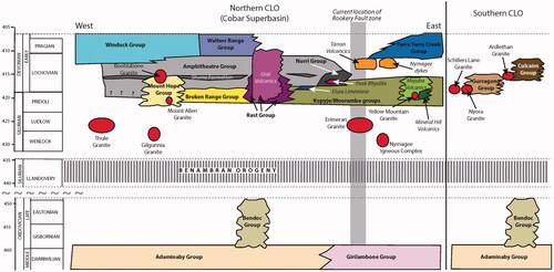
Small, isolated coherent rhyolite bodies and correlative shallow-level ‘porphyry’ intrusions occur at two stratigraphic levels within the siltstone-rich packages of the deep-water Cobar Basin (). In the east, coherent, flow-banded rhyolite bodies (Perseverance and Peak rhyolites) are present at a complex faulted stratigraphic boundary between the Great Cobar Slate (siltstone-rich) and the Chesney Formation (sandstone-rich) of the Nurri Group. Subordinate volcanic-derived sandstone is also interbedded with the surrounding siltstone-rich sequences. The Stones Tank Tuff Member (immature volcaniclastic deposits and lesser coherent rhyolite; Felton, Citation1981) occurs at similar stratigraphic levels to the south and is interbedded with the siltstone-rich sequences of the lower Amphitheatre Group and upper Burthong Formation (shallow-water equivalent of the Nurri Group). Zircon U–Pb (SHRIMP) ages for these rhyolites range from 423 to 419 Ma, which is consistent with the age of the lower Cobar Basin sequences elsewhere (Black, Citation2006; Downes et al., Citation2016; Jones et al., Citation2020). While the origin of the clastic beds is likely deep-water deposition with a potential eastly shelf source, the origin of the larger coherent rhyolite bodies has been disputed—being anything from allochthonous through to ocean floor lavas—but it is likely they are shallow-level sills; domes formed close to the sea floor within the deep-water sequences (Whittock, Citation2007). The contemporaneous porphyry stocks (e.g. Bee Porphyry) have been dated at ca 420–417 Ma (Black, Citation2006) and are hosted solely within the Chesney Formation of the Nurri Group.
In the central Cobar Basin coherent porphyritic rhyolite bodies occur at a higher stratigraphic level in the deep-water basin sequences as isolated bodies (Shuttleton Rhyolite Member and unnamed rhyolite encountered in drill core at the Wirlong prospect) within the sandstone-rich Shume Formation or intercalated with distinctive limestone-rich mass flow horizons within the Shume Formation (; Mallee Bull prospect; Brown et al., Citation2013; Edgecombe & Soininen, Citation2019). Zircon U–Pb (SHRIMP) age dates for these rhyolite bodies range between 422 and 419 Ma (Jones et al., Citation2020). The Shume Formation is interpreted to represent the boundary between the rift and sag phases of the deep-water Cobar Basin (Glen, Citation1994). Interestingly, the correlative Biddabirra Formation on the northern deep-water Cobar Basin hosts allochthonous limestone blocks of suggested Pragian age (410–407 Ma; Mathieson et al., Citation2016) providing a maximum age for the rift-to-sag transition in the Cobar Basin, although the time–space plots of Glen et al. (Citation1985) and MacRae (Citation1989) suggest that some diachroneity in the transition to sag phase deposition in the eastern vs western deep-water Cobar Basin. Ebach (Citation2002) assigned trilobite fauna from the Biddabirra Formation to a Lower Devonian (Lockhovian–Pragian) age, although the author suggests the fauna are consistent with a Lockhovian age. Again, the relationship of the isolated volcanic rocks to the deep-water basin sedimentary rocks has been conjectured, and allochthonous (outrunner and olistolithic) or shallow-level syn-depositional sill origin suggested. However, recent work has favoured an allochthonous origin, likely sourced from the Mount Hope Trough to the east (Brown et al., Citation2013; Chapman, Citation2012; Jones et al., Citation2020). An allochthonous origin may explain the apparent diachroneity in the onset of sag phase sedimentation across the Cobar Basin and potentially the ca 10–15 Ma mismatch between the paleontological determinations and the U–Pb geochronology, suggesting that a mixed source from the shelf to the west and/or either emergent or uplifted parts of the Mount Hope Group. Unfortunately, the mismatch between different paleontological determinations and U–Pb geochronology means there is still some degree of ambiguity around the relationship of central Cobar Basin rhyolite bodies and their host deep-water sequences.
No large intrusive bodies have been observed to intrude the deep-water sedimentary sequences of the Cobar Basin, although a number of small fault-focused, I- and A-type, ca 415 Ma dykes have intruded basement beneath the basin as well as intruding parallel to the Rookery Fault within the shallow-water sequences of the Mouramba Group (temporal equivalent of the Nurri Group in the north). Several moderate to large intrusions have been inferred to have intruded immediately beneath or within the lower Cobar Basin sequences based on geophysical interpretation and mineral system studies (Fitzherbert et al., Citation2021; Fitzherbert & Downes, Citation2020; Ford et al., Citation2020; Forster & Seccombe, Citation1999).
Northern volcanic successions—S-, I- and A-type classification
Northern Cobar Basin
The time–space relationships of the northern volcanic succession are depicted in .
Florida Volcanics and Baledmund Formation
The Florida Volcanics has a U–Pb SHRIMP age for magmatic zircons of 421.7 ± 2.3 Ma (Black, Citation2005), and more recent dating of the Baledmund Formation yielded an age of 419.3 ± 2.8 Ma (Table S1; Bodorkos et al., Citation2015). Simpson (Citation2015b) interpreted the Baledmund Formation volcanic deposits to represent the distal deposits of coherent and volcaniclastic facies of the Florida Volcanics. Those deposits contain pseudomorphs of probable amphibole phenocrysts and crystals, which we suggest are indicative of metaluminous (‘I-type’) classification (Blevin, Citation2004; Blevin & Jones, Citation2004), although Chappell et al. (Citation1991) classified the Florida Volcanics as peraluminous (‘S-type’).
Shallow-level intrusions of the northeast Cobar Basin (Perseverance rhyolite, Bee Porphyry, Stones Tank rhyolite; dacitic sills)
The Perseverance rhyolite is a subvolcanic to extrusive, rhyolite complex comprising coherent rhyolite and volcaniclastic facies that include welded and non-welded tuffs or ignimbrite, hyaloclastite breccia and peperite (Whittock, Citation2007). The facies were emplaced in a subaqueous backarc basin environment within the Chesney Formation, northern Cobar Basin, and are exposed at Peak Gold Mine, approximately 10 km south of Cobar (Munro et al., Citation2004; Whittock, Citation2007). Fitzherbert et al. (Citation2020) interpreted the banded texture in coherent facies of the Perseverance rhyolite to be flow banding (cf. Munro et al., 2004; Whittock, Citation2007). Previous interpretations of the presence of welding suggest the deposits were emplaced in shallow-water or subaerially, which is inconsistent with the basin model.
The Perseverance rhyolite is pyroxene-bearing, variably sericite- and chlorite-altered, and has been interpreted to be sub-alkaline, shoshonitic rhyolite in composition. Pyroxene phenocrysts suggest the rhyolite is most likely metaluminous (‘I-type’). The Bee Porphyry was dated by U–Pb SHRIMP analysis of zircon to be 417 ± 3.0 Ma (Black, Citation2005) and is interpreted to represent a coarse-grained high-level intrusive equivalent to the Perseverance rhyolite. Jones et al. (Citation2020) also described a hornblende-phyric I-type dacitic sill dated at 410.8 ± 1.9 Ma that intrudes the Meryula Formation of the Kopyje Group at the derelict Rabbit Hill mine east of Cobar township.
East/central Cobar Basin
The Majuba, Babinda and Yarnel volcanics of the Canbelego-Mineral Hill Belt have been characterised by Chappell et al. (Citation1991) as S-type, although volcanic rocks of the belt were reclassified as metaluminous (I-type) by Blevin and Jones (Citation2004). The Tarran Volcanics within the basin centre has been classified as metaluminous (‘I-type’) by Chappell et al. (Citation1991), and as ‘A-type’ by Blevin and Jones (Citation2004).
Mount Hope and Rast troughs
Mount Hope Group volcanic rocks
The Mount Hope Group is interpreted to represent deep-marine lava domes, volcaniclastic aprons and pyroclastic deposits (Bull, Citation2006; Simpson, Citation2015b). Multiple volcanic centres were postulated by Simpson (Citation2015b), based on interpretations of proximal and distal volcanic facies and on spatially associated and differing compositional variations within the Mount Hope volcanic rocks. Although limited initial chemical analyses indicated an A-type affiliation for some of the Mount Hope volcanic rocks (Bull et al., Citation2008), subsequent interpretations suggest at least some of the deposits (e.g. Mount Halfway, Nombiginni and Regina volcanics) are peraluminous and have an S-type affinity (Downes et al., Citation2016) or early eruptive products an I-type affinity (e.g. Mt. Kennan Volcanics; David, Citation2006).
Ural Volcanics
Major- and trace-element data for the Ural Volcanics (including Mount Hope Volcanics samples) indicate that the rocks are weakly peraluminous (ACNK 1.0–1.1) and sub-alkaline. The Ga/Al ratio is >2.5 and Ga/Al vs Nb data for the Ural Volcanics plot in A-type field (Bull, Citation2006; Bull et al., Citation2008). In addition, the data show decreasing P2O5 with increasing SiO2, low CaO + Fe2O3 and high Zr. These data and the variably high K, Zr, Nb and Y contents are consistent with A-type affinities.
Discussion
Facies interpretations and implications for the Southern CLO—pyroclastic deposits
The high concentration of crystals within a welded, banded matrix suggests the crystal-rich volcaniclastic sandstone units in the Gurragong and Culcairn groups are subaerial but are not welded ash-fall deposits. Concentrated crystals and sparse ash require a transport and depositional mechanisms that force winnowing of small, light particles and concentration of denser pyroclasts (crystals, lithic clasts), such as deposition from a pyroclastic density current (Walker, Citation1972). The minimal presence of spatially associated non-welded facies (excepting the pumice-rich Indarra Tuff facies) is likely in large part due to the rapid distribution of ash from wind and subsequent erosion, resulting in a lack of preservation.
Within the limited outcrops remaining there is generally a lack of discernible internal stratification or grading, with two notable exceptions: within the Wallandoon Ignimbrite where large, compacted pumice clasts provide a subhorizontal stratification; and consistent, subhorizontal joints within the crystal-rich facies on Big Budginigi Hill that suggest flow laminae or weak bedding. Massive to weakly stratified units are common in moderate- to large-volume pyroclastic density deposits.
The exposures of the variably welded ignimbrites are vestiges of what must have been thick pyroclastic-flow deposits. The remaining Gurragong Group outcrops indicate that the crystal-rich facies form a south-southeast-trending lobate package at least ∼200 km2, and the remnant, exposed thickness, presuming it is relatively flat-lying, ranges from 3 to 140 m. The facies east of Ardlethan forms a series of exposures over a south-southeast-trending area of approximately 155 km2, and in the Milbrae (formerly Walleroobie) Quarry the unit is exposed for ∼50 m vertically, suggesting a primary thickness perhaps twice that. Using an average thickness range of 50–100 m, an approximate minimum volume of the Walleroobie Ignimbrite is 18–35 km3.
Similarly, ∼100 km to the south, the variably welded Budginigi Ignimbrite has an exposed thickness of up to 200 m, and the Wallandoon Ignimbrite is 60–100 m thick. Collectively the units form two large lobes about 198 and 600 km2, respectively. If we use an average thickness range of 100 m, therefore, the average minimum volume of pyroclastic units in the southern CLO volcanic belt is roughly estimated to range from 15 to 75 km3 for each, the Budginigi and Wallandoon ignimbrites. This volume estimates, in conjunction with the crystal-rich, massive and, at least in part densely welded nature to the facies imply they represent subaerial, relatively distal pyroclastic density current deposits (ignimbrites). Such fairly large-volume (i.e. ≥25 km3) crystal-rich ignimbrite facies are common in Australia (e.g. McPhie, Citation1983, Citation1984; White & McPhie, Citation1996; Wyborn et al., Citation1981). In contrast, a volume estimate for the deep marine Ural Volcanics explosive products is about 3 km3 (Bull & McPhie, Citation2006).
The southern CLO deposits are most likely the result of large-scale column collapse-induced, rather than dome-collapse-induced, pyroclastic density currents due primarily to their moderately high volume. Dome-collapse ignimbrites also tend to contain abundant, predominantly monomictic, dense coherent clasts (e.g. Calder et al., Citation2000). The mixed nature and low relative abundance (<10%) of lithic clasts within local areas of the Walleroobie Ignimbrite suggest they are accidental clasts picked up from the substrate rather than dense fragments from a dome-collapse density current (Bryan et al., Citation1998; Gardner et al., Citation1994) and may represent a proximal or even intra-caldera lag-breccia facies (Druitt & Bacon, Citation1986).
The predominantly felsic composition of the ignimbrites suggests that these would have been highly explosive eruptions (i.e. plinian to subplinian) and likely caldera-related. Small thicknesses and the moderately large areal extent of the deposits (tens of kilometres) may suggest they are caldera outflow facies. However, the lack of non-welded facies suggests large stratigraphic thicknesses have been lost to erosion, which may suggest that the deposits are the welded remnants of a thick intra-caldera pile. The lack of internal structure and of additional facies, and the presence of the Corella Ignimbrite lithic-rich breccia could support an intra-caldera context for these deposits.
The Walleroobie Ignimbrite contains what appear to be S-type granitic clasts that are of varying sizes and in places appear to have been disaggregated. The granitic clasts have no reaction rim and seem to be in equilibrium with the melt. Two implications follow: the volcanic melt is either sourced from such granitic rocks, or the melts have picked up granitic clasts early enough in the melt transport to partly disassemble them, as well as lengthen and align them within the flow. The best example of this is on Bolero Mountain within the Walleroobie Ignimbrite (, ), but similar textures may be found in the southern Walleroobie Ignimbrite such as in Milbrae Quarry. Meta-sedimentary lithic clasts within the ignimbrite, however, are consistently angular and considered accidental.
Associated intrusions and contact metamorphism of volcanic facies
Walleroobie Ignimbrite exposures exhibit granoblastic textures east and south of the Yalgogrin Ranges to Ardlethan, and southeast through Milbrae Quarry (). Soldiers Quarry Member of the Budginigi Ignimbrite also exhibits granoblastic recrystallisation, including secondary biotite. These contact metamorphic textures suggest a high-level, high-temperature pluton intruded post volcanism under a large portion of an area between West Wyalong to the southeast of Ardlethan.
Bouger gravity data over the East Riverina study area between West Wyalong and Albury show coincident relative low gravity response beneath the majority of the Gurragong Group (). This low gravity response coincides well with the full extent of the Gurragong Group and includes the contemporaneous Ardlethan Granite (Duca) (414.7 ± 2.3 Ma; Bodorkos et al., Citation2013), the Sprys Tank Granite (Skos) north of Ardlethan, and the Bungambil Granite southeast of Ardlethan () (Bodorkos et al., Citation2021; Colquhoun et al., Citation2019; Trigg, Citation2016). Interestingly, the Gurragong Group units that form hills between the Newell Highway and the Mirool Road, northeast of Ardlethan, are not underlain by a low relative gravity anomaly and are not contact metamorphosed.
The scale of contact metamorphic recrystallisation in the peraluminous Walleroobie Ignimbrite implies reheating by a large, relatively hot intrusion, possibly reflected in the extensive low gravity anomaly underlying most of Gurragong Group exposures. Limited exposures restrict us from better knowledge of contact relationships between the volcanic facies and intrusions, except in drill core and mine exposures at the Ardlethan Mine. In this context, the Walleroobie Ignimbrite (formerly the ‘GQF Porphyry’ unit in the Ardlethan Mine area) was intruded by the Ardlethan Granite, which itself is cross-cut by the Yithan Porphyry (formerly the ‘Mine Porphyry’) (Bull & Blevin, Citation2016; Ren, Citation1989; Ren et al., Citation1995). The Yithan Porphyry has been dated at 412.0 ± 1.9 Ma (‘Cassiterite porphyry’, Bodorkos et al., Citation2013). Recent sampling suggests it is a metaluminous I-type intrusion.
Metaluminous, I-type magmas are characterised by greater degrees of fractionation and higher oxidation states than S-type, peraluminous magmas, and thus are associated with higher magmatic temperatures than S-type intrusions (Blevin & Chappell, Citation1992, Citation1995). The peraluminous, S-type Walleroobie Ignimbrite would likely, then, have been recrystallised not by an intrusion of similar composition like the contemporaneous Ardlethan Granite, but perhaps by a large, unexposed I-type intrusion that is reflected in the large gravity low underlying the Gurragong Group volcanic sequences.
The gravity response underlying the granoblastic Soldiers Quarry Member is only moderately low; lower relative gravity responses are 10–15 km to the west, under the metaluminous I-type Jindera Granite (407–403 Ma; Bodorkos et al., Citation2021; Bull, Citation2017), and slightly lower responses to the east under the Black Rock, Ralvona, Woomargama and similar granites (429–428 Ma; Bodorkos et al., Citation2015; Bull, Citation2017; Campbell, Citation2018). The Wallandoon Ignimbrite, which comprises extensive, highly magnetic metaluminous I-type deposits, is notably not underlain by a low gravity response, suggesting the source for the extrusive rocks is not necessarily reflected in a large underlying intrusion.
Level of emplacement
In the southern CLO, Gurragong and Culcairn group volcanic units directly (disconformably) overlie not only Ordovician meta-sandstone of the Ordovician Adaminaby Group, but also upper Silurian granitoids, such as the Sprys Tank Granite at the Ardlethan Mine (428.1 ± 2.8 Ma called the ‘Mine granite’ in Bodorkos et al., Citation2013), Wantabadgery Granite east of the southern Walleroobie Ignimbrite (431.3 ± 4.1 Ma, Ickert & Williams, Citation2011), and the Mount Royal Granite at and near the Hickory Hill mine, west of the Wallandoon Ignimbrite (430.5 ± 3.4 Ma, Waltenberg et al., Citation2019). These relationships imply not only rapid uplift and erosion of basement and upper Silurian granites prior to Siluro-Devonian eruptions, but also very high levels of emplacement for those ca 430 Ma granites.
In fact, there are a remarkable number of examples in the CLO where volcanic facies are spatially and chemically associated with contemporaneous granitic intrusions. Such examples include the Nymagee felsic dykes, Blind Calf dyke swarm and the Mineral Hill Volcanics; the Yellow Mountain Granite and the Majuba Volcanics; the Mount Allen, Boolahbone and Gilgunnia granites and the Mount Hope Group; the Nyora, Ardlethan, Beckom South, Yarranjerry, Boblegigbie, granites associated with the Gurragong Group (Black, Citation2007; Bodorkos et al., Citation2016; Downes et al., Citation2016; Fitzherbert et al., Citation2016, Citation2019). Close depositional contacts of ignimbrites and coeval intrusions imply high-level emplacement of these ca 415 Ma intrusions; granites virtually intruding their ‘own’ volcanic pile or at least similarly sourced eruptive products.
Tectonic control on the CLO volcanic belt
Previous workers have recognised post-compressional marine rift basins that formed during deformation cycles in the Lachlan Orogen, and the importance of those basins being the focus for magmatism and related ore deposits (e.g. Bierlein et al., Citation2002; Glen, Citation1995; Glen et al., Citation1996; Gray & Gregory, Citation2003; Perkins et al., Citation1994; Scheibner, Citation1973). Structures driving the opening of the Cobar Basin and the volcanogenic Rast and Mount Hope troughs during the Tabberabberan Cycle (433–380 Ma) controlled magmatic activity and mineralising fluids in the basins owing to maximum northeast–southwest-oriented extension that resulted in sinistral transtension (Collins & Richards, Citation2008; Foster et al., Citation1999; Glen, Citation1990, Citation2005; Glen et al., Citation1985). These troughs have controlled and confined the eruptive products, and the underlying structures have been the focus of ongoing deformation as well as intrusive activity and periodic mineralisation at ca 420 Ma, 415–410 Ma, 405–395 Ma, and 390–380 Ma (; see Fitzherbert et al., Citation2019 for details of direct dating of mineralisation; Fitzherbert et al., Citation2016; Perkins et al., Citation1994; Solomon & Groves, Citation1994). In the Cobar Basin, primary, marine volcanic deposits are associated with shelf deposits on the basin margins and approximately coeval felsic dykes that intruded volcanic facies (e.g. Kopyje Group; Simpson, Citation2015a; Downes et al., Citation2016). Contact metamorphic aureoles and related mineralisation suggest larger scale intrusions at depth and ongoing mineralisation during basin rifting (Fitzherbert et al., Citation2016, Citation2017, Citation2019; Leverett et al., Citation2005). The Mount Hope and Ural volcanic successions provide evidence for multiple volcanic centres within deep marine (central basin) settings that include explosive and effusive eruptions associated with shallow-level intrusions (Bull, Citation2006; Bull & McPhie, Citation2006; Colquhoun et al., Citation2005; Simpson, 2005b). The southern CLO, subaerial volcanic successions, newly described here, are generally contemporaneous with the marine volcanic belts in the Cobar, Rast and Mount Hope depocentres, and we suggest that these were similarly controlled by extensional tectonics. The subaerial depositional environment of the southern volcanic successions suggests less subsidence than their northern siblings.
Figure 19. Results of the recent direct dating of zircon U–Pb age results for intra-basin magmatic rocks of the Cobar Basin and southern CLO volcanic successions discussed in this paper. Details of magmatic rock U–Pb ages, including references, can be downloaded from the geochronology tab of MinView on the NSW Department of Planning, Industry and Environment website (https://minview.geoscience.nsw.gov.au/#/?l=gc1:y:100&lat = 148.09399811093877&lon=-32.46504582679845&z = 10&bm = bm1). Basin sedimentation stages are based on Glen (Citation1987, Citation1994), Parrish et al. (Citation2018) and the recent paleontological review of Mathieson et al. (Citation2016).
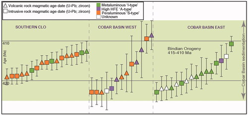
The changing volcanic facies and thus interpreted paleogeography from south to north during the Siluro-Devonian can be thought of in terms of the recent tectonic reinvention of the Lachlan Orogen as an oroclinal system developed through the southern accretion of the Vandieland microcontinent during the Ordovician, and its effects on the development of the successor Siluro-Devonian subduction system (e.g. Cayley, Citation2015; Cayley et al., Citation2012; Huston et al., Citation2015, Citation2016; Moresi et al., Citation2014). In this model, the prior embedment of the Vandieland microcontinent in the southern Lachlan Orogen created south-to-north asymmetry and a retreating west-dipping slab responsible for the development of the Siluro-Devonian backarc systems (Cayley, Citation2015; Collins, Citation2002). As depicted in the microcontinent is envisaged to have pinned the southern end of the retreating slab, while the northern parts of the slab were uncongested and in free-rollback within an enforced transtensional environment associated with large-scale strike-slip faulting (Cayley, Citation2015; Moresi et al., Citation2014). The asymmetry generated by this model elegantly explains the paleogeographic transition of a subaerial terrestrial environment for the southern CLO volcanic belt, to the contemporaneous development of the northern CLO volcanic belt within the moderate- to deep-water, transtensional backarc rift Cobar Basin (). Basement composition played a vital part in the changing genetic character of the CLO volcanic rocks within this asymmetric tectonic environment. The interplay between tectonic evolution and basement composition imparted control on the associated Siluro-Devonian metallogeny of the region and is discussed below.
Figure 20. Cartoon reconstruction of the Lachlan Orogen at ca 440 Ma (a), 430–410 Ma (b) and <410 Ma (c) based on the Vandieland microcontinent accretion model of Moresi et al. (Citation2014) including elements from Cayley (Citation2015) and Huston et al. (Citation2016). The approximate locations of the Cobar Basin, southern CLO volcanic sequences and Gilmore/Rookery fault zone (GRF) have been added to highlight their relationship to the accreting microcontinent. See text for further details.
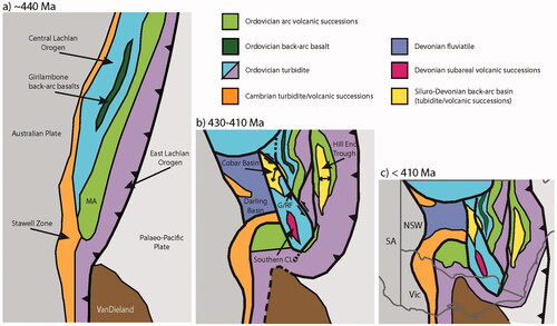
Ordovician basement, Siluro-Devonian volcanism and mineralisation in the CLO
The CLO Siluro-Devonian volcanic belt and associated intrusions is one of the most extensive and voluminous volcano-plutonic complexes in Australia. Differences in the interpreted source (I-, A- and S-type magmatism) of the different volcanic successions of the CLO volcanic belt () coincide broadly with spatial variations in metallogeny (e.g. Cu–Au or Zn–Au or Pb–Zn–Ag or Sn–W-dominant); a time–space plot for basement and successor basin sequences, including the volcanic successions of the CLO is presented in . These differences are in turn commensurate with variations in basement character along and across the belt (i.e. Blevin & Jones, Citation2004; Chappell et al., Citation1988) as well as influences stemming from variable tectonic regimes along the belt during the period of active volcanism. The northern volcanic successions straddle the boundary between two distinct packages (mostly separated by the Rookery Fault system) of craton-derived Ordovician turbidites that developed in a likely backarc setting (e.g. Gilmore et al., Citation2018). The Girilambone Group constitutes the eastern basement package (mostly east of the Rookery Fault; ) and is largely a sequence of monotonous siliciclastic turbidite, but importantly is intercalated with a range of autochthonous mafic (basaltic) volcanic rocks of within plate and MORB affinities (Burton, Citation2012, Citation2014); these basalts are associated with Ordovician aged Cu-rich Beshi-style volcanic-hosted massive sulfide (VHMS) mineralisation (e.g. Tritton mine; Gilmore et al., Citation2018). The Girilambone Group is considered to be a remnant of the backarc basin associated with the Ordovician Macquarie Volcanic Arc to the east (e.g. Huston et al., Citation2015). To the west of the Rookery Fault, the Adaminaby Group () is also largely a sequence of monotonous siliciclastic turbidite, but here the Ordovician sequences include an upper, condensed package of Upper Ordovician black mudstone (Bendoc Group; ) and there is no contemporaneous mafic volcanism. The uppermost Silurian to Lower Devonian Mount Hope and Rast troughs unconformably overlie the Ordovician Adaminaby/Bendoc groups sequences and are dominated by S- and A-type volcanism (Blevin & Jones, Citation2004). About 415 Ma the A-type Tarran Volcanics were intruded and erupted along with the Rookery Fault system immediately south of the Cobar Basin (Blevin & Jones, Citation2004). Isolated I-type rhyolite bodies (e.g. Peak Rhyolite: ) occur within the eastern deep-water Cobar Basin sequences and in conjunction with the I-type Siluro-Devonian Kopyje Group volcanic successions (e.g. Mineral Hill Volcanics and Majuba Volcanics; ), and also overlie a Girilambone Group basement. The southern CLO volcanic successions and intrusions are S-type dominant and have developed solely in and over the Adaminaby/Bendoc group basement (). The character of the lower crust that melted to produce the volcanic and plutonic sequences that overlie these two Ordovician turbidite domains—S/A-type in the west and south, and I-type in the east (Blevin & Jones, Citation2004)—fundamentally varies, and these basement variations have strongly influenced the nature of the successor, Siluro-Devonian volcanic troughs/belts.
The strongly domanial inherited lower crust character not only had an overarching control on the genetic character of the CLO volcanic sequences but initiated a domino effect controlling the subsequent metallogeny within the successor basins that overlie these domains (see Blevin & Jones, Citation2004; Chappell et al., Citation1988; Huston et al., Citation2015, Citation2016). A fundamental metallogenic divide exists in the Cobar Basin (), with Cu–Au VHMS mineralisation, hosted by Ordovician quartz-rich turbidites of the Girilambone Group, being concentrated in the northeastern basin and within the Canbelego-Mineral Hill Volcanic Belt, and even within the intervening basement (i.e. along with and east of the Rookery Fault). The metallogeny west of the Rookery Fault is blurred by the additional Pb–Zn–Ag fertility of the Cobar Basin sedimentary rocks and the position of the boundary between eastern Girilambone basement and Adaminaby/Bendoc group basement is obscured by the deep-water basin sequences in the north. Nevertheless, Blevin and Jones (Citation2004) noted that the metallogeny of the eastern Cobar Basin and Canbelego-Mineral Hill Volcanic Belt is typical of I-type magmatic-hydrothermal associations, while the metallogeny of prospects associated in the Mount Hope and Rast troughs is more typical of A-type magmatic-hydrothermal associations. Deposits such as the Au–Zn-rich Hera orebody in the southeastern Cobar Basin may also fall into this A-type metal association and curiously occur directly above the Girilambone/Adaminaby basement divide, which has been exploited by A-type melts in this southern region. Even deposits such as the Pb–Zn-rich parts of the Mallee Bull orebody in the central Cobar Basin contain anomalous Sn, display inherited Pb isotopic composition consistent with the Ordovician basement (Downes & Poulson, Citation2018) and almost certainly overlie Adaminaby/Bendoc group basement. The contemporaneous southern CLO volcanic rocks erupted exclusively over Adaminaby/Bendoc group basement and host predominantly Sn–W mineralisation; these deposits extend northward to just south of the Cobar Basin (e.g. Tallebung deposit). This mineralisation is thus related to lower crustal melting and concentration of Sn–W during S-type magmatism between ca 420 and 412 Ma.
VHMS and contemporaneous epithermal deposits are proposed to exist in the Mount Hope Group and the Canbelego-Mineral Hill Volcanic Belt (e.g. David, Citation2006; David & Glen, Citation2004; Edgecombe & Soininen, Citation2019), whereas in the deep-water sedimentary sequences massive sulfides are turbidite-hosted and have a strong spatial association with basin faults. Lawrie and Hinman (Citation1998) proposed an orogenic base metal model for these deposits, whereby Cu–Au were leached from the fertile basalt-bearing Girilambone Group and its basement rocks during basin inversion and Pb–Zn–Ag-rich deposits originated from deep Cobar Basin aquifers during inversion. The latter is certainly true, but Fitzherbert et al. (Citation2019, Citation2021) and Fitzherbert and Downes (Citation2020) presented evidence for a likely pre-inversion magmatic character to the Cu–Au-rich eastern Cobar orebodies and dated the mineralising event to ca 414–408 Myr, which is ca 20 Myr years prior to the ca 390–380 Ma inversion of the Cobar Basin and ca 6–12 Myr younger than much of the inter- and intra-basin magmatism. However, A-type magmatism in the western basin and along the Rookery Fault occurred between 415 and 412 Ma (Boolabone Granite, Ural and Tarran volcanics) along with limited I-type magmatism to 411 Ma in the mineralised northeastern Cobar Basin. We propose the orogenic mineral system model is missing a key step in the metal fertility cycle, this being the further concentration of metals through melting of the fertile lower crust during the Cobar rifting event followed by magmatic transport to near depositional sites via major faults, and final concentration through magmatic crystallisation processes. The faults that control much of the mineralisation are transcrustal, and multiple mineralising events are possible during even small fault motions over the rifting period and potentially into the sag phase of the basin evolution. For syndepositional and basin inversion deposits the metal budget of the successor basin will contribute to the metallogeny. In the case of the Cobar, basin-derived Pb–Zn–Ag mineralisation also occurred during basin inversion, while many deposits along the major fault systems were remobilised and concentrated during inversion (Fitzherbert & Downes, Citation2020). Thus, the complex metallogeny and relatively large metal endowment of the Cobar Basin has resulted from a combination of enhanced lower crustal fertility, located over a major transcrustal structure(s) that divides two fundamentally different lower crustal domains, increased fertility through lower crustal melting and metal concentration through magmatic processes during successor basin formation and emplacement of the northern CLO volcanic belts. Inversion-related mineralisation further diversified and bolstered the metal endowment, no doubt benefiting from the new basin fertility and the two phases of magmatic metal enrichment that preceded.
As discussed in the previous section, the proposed tectonic regime during the Siluro-Devonian produced the terrestrial topography in the southern CLO and development of the transtensional marine Cobar rift basin in the north. Subaerial volcanism in the southern CLO occurred in combination with deposition broadly coincident with basement-controlled S-type magmatism. The metal budget resulted in intrusion-related Sn–W as a viable mineralising system. In contrast, the northern CLO was a marine environment proximal to a major transcrustal structure. The fertility of the lower crustal rocks varied from west to east and led to the development of diverse mineral systems. This included rift-related VHMS, epithermal, skarn (Cu–Zn–Au) and intrusion-related deposits (Fitzherbert & Downes, Citation2020). Inversion generated new deposits from the newly developed basin and remobilised/concentrated older deposits, building and further diversifying the metal endowment in this region.
Summary
The CLO volcanic belt in NSW represents emplacement of predominantly silicic, explosive and effusive eruptive products within an approximately 350 km long, 20 km wide series of elongate basins from approximately 428 to 411 Ma. A coincident belt of contemporaneous granitic intrusions makes this one of the most extensive and voluminous volcano-plutonic complexes in Australia.
In the northern volcanic belt, the Cobar Basin and its broadly north–south-oriented volcanic sub-basins, such as the Rast and Mount Hope troughs, opened coeval to volcanic activity in the volcanic belt owing to sinistral transtension. These troughs have controlled and confined the eruptive products. We suggest the Gurragong and Culcairn groups' subaerial pyroclastic deposits were similarly controlled by extensional tectonics. The subaerial depositional environment of the southern volcanic successions suggests the basins experienced less subsidence than their northern siblings, and the proximity of exposed Siluro-Devonian granites, and the contact metamorphic overprint by younger intrusions, imply shallow intrusion depths accompanied by uplift and erosion of the intrusions prior to and during rift development.
The volcanic rocks produced in these extensional basins, rather than being bimodal are almost exclusively silicic. Despite being consistently felsic, there is a variation in the aluminium saturation index from peraluminous to metaluminous, and variation in high-field strength elements that may reflect variation in the source rocks and temperature of partial melting. These variations probably affected the associated mineralising fluids, resulting in metallogenic patterns that reflect these basement differences. The metal budget in the southern CLO resulted in intrusion-related Sn–W as a viable mineralising system. In contrast, the northern CLO was a marine environment proximal to a major transcrustal structure. The fertility of the lower crustal rocks varied from west to east and led to the development of diverse mineral systems.
Supplemental Material
Download PDF (312.2 KB)Acknowledgements
We gratefully acknowledge the inspiration from and discussions with P. L. Blevin, and outcrop exchanges and mapping dialogues with members of the GSNSW East Riverina project regional mapping team during mapping of the volcanic facies. Astrid Carlton provided great assistance with geophysical interpretations. We also thank Rick Squire and an anonymous reviewer for their constructive comments and excellent suggestions.
Disclosure statement
No potential conflict of interest was reported by the authors.
References
- Adamson, G. L., & Lowdon, A. G. (1966). Geological Map Wagga Wagga Sheet SI155-15 1:250 000 (D004951690). Geological Survey of New South Wales.
- Allan, A. D. (1993). Report No PK93/54S Cobar Supergroup Project Exploration licence 3255 “Lachlan Downs” first annual report for the period ended 16th January 1993.
- Bierlein, F. P., Gray, D. R., & Foster, D. A. (2002). Metallogenic relationships to tectonic evolution–the Lachlan Orogen. Earth and Planetary Science Letters, 202(1), 1–13. https://doi.org/10.1016/S0012-821X(02)00757-4
- Black, L. P. (2005). SHRIMP U–Pb zircon ages obtained during 2004/05 for GSNSW. Geological Survey of New South Wales, Report GS2005/745.
- Black, L. P. (2006). SHRIMP U–Pb zircon ages obtained during 2005/06 for NSW Geological Survey projects. Geological Survey of New South Wales, Report GS2006/821.
- Black, L. P. (2007). SHRIMP U–Pb zircon ages obtained during 2006/07 for NSW Geological Survey projects. Geological Survey of New South Wales, File GS2007/298.
- Blevin, P. L. (2004). Redox and compositional parameters for interpreting the granitoid metallogeny of eastern Australia: Implications for gold-rich ore systems. Resource Geology, 54(3), 241–252. https://doi.org/10.1111/j.1751-3928.2004.tb00205.x
- Blevin, P. L., & Chappell, B. W. (1992). The role of magma sources, oxidation states and fractionation in determining the granite metallogeny of eastern Australia. Earth and Environmental Science Transactions of the Royal Society of Edinburgh, 83(1–2), 305–316. https://doi.org/10.1017/S0263593300007987
- Blevin, P. L., & Chappell, B. W. (1995). Chemistry, origin and evolution of mineralized granites in the Lachlan Fold Belt, Australia: The metallogeny of I- and S-type granites. Economic Geology, 90(6), 1604–1619. https://doi.org/10.2113/gsecongeo.90.6.1604
- Blevin, P. L., Jones, M. (2004). Chemistry, age and metallogeny of the granites and related rocks of the Nymagee region, NSW. In Proceedings of the Exploration Field Workshop Cobar Region, (pp. 15–19). CRC LEME publication.
- Bodorkos, S., Blevin, P. L., Eastlake, M. A., Downes, P. M., Campbell, L. M., Gilmore, P. J., Hughes, K. S., Parker, P. J., & Trigg, S. J. (2015). New SHRIMP U–Pb zircon ages from the Central Lachlan Orogen, New South Wales. Geological Survey of New South Wales Report GS2015/0002; Geoscience Australia Record 2015/02.
- Bodorkos, S., Blevin, P. L., Simpson, C. J., Gilmore, P. J., Glen, R. A., Greenfield, J. E., Hegarty, R., & Quinn, C. D. (2013). New SHRIMP U–Pb zircon ages from the Lachlan, Thomson and Delamerian orogens, New South Wales. Geological Survey of New South Wales Report GS2013/0427; Geoscience Australia Record 2013/29.
- Bodorkos, S., Bull, K. F., Campbell, L. M., Eastlake, M. A., Gilmore, P. J., & Trigg, S. J. (2016). New SHRIMP U–Pb zircon ages from the central Lachlan Orogen and New England Orogen, New South Wales. Geological Survey of New South Wales Report GS2016/0343; Geoscience Australia Record 2016/21.
- Bodorkos, S., Eastlake, M. A., Waltenberg, K., Bull, K. F., Gilmore, P. J., Campbell, L. M., Trigg, S. J., Blevin, P. L., Deyssing, L. J., Williams, B. J. (2021). New SHRIMP U–Pb ages from the Lachlan Orogen, New South Wales: East Riverina Project, July 2016–June 2020. Record 2021/08, Geoscience Australia; Report GS2019/1089, Geological Survey of New South Wales. https://doi.org/10.11636/Record.2021.008
- Bodorkos, S., Main, P. T., Bull, K. F., Campbell, L. M., Eastlake, M. A., Gilmore, P. J., Trigg, S. J., & Waltenberg, K. (2018). New SHRIMP U–Pb ages from the Central Lachlan Orogen, New South Wales: Regional Mapping projects, July 2015–June 2016. Geological Survey of New South Wales Report GS2018/0313; Geoscience Australia Record 2018/17.
- Breitkreuz, C. (2013). Spherulites and lithophysae—200 years of investigation on high-temperature crystallization domains in silica-rich volcanic rocks. Bulletin of Volcanology, 75(4), 705–716. https://doi.org/10.1007/s00445-013-0705-6
- Brown, B., Chapman, N., & Oates, M. (2013). The Mallee Bull discovery and exploration in the central Cobar Basin. In P. C. Lewis (Ed.), Mineral exploration in the Tasmanides, Mines & Wines 2013 (pp 5–12). Australian Institute of Geoscientists Bulletin 55.
- Brunker, R. L., & Offenberg, A. C. (1970). Macquarie 1:500 000 Geological Map. 1st edition. Geological Survey of New South Wales.
- Bryan, S. E., Cas, R. A., & Martı, J. (1998). Lithic breccias in intermediate volume phonolitic ignimbrites, Tenerife (Canary Islands): constraints on pyroclastic flow depositional processes. Journal of Volcanology and Geothermal Research, 81(3–4), 269–296. https://doi.org/10.1016/S0377-0273(98)00004-3
- Bull, K. F. (2006). Facies architecture, geochemistry and tectonic significance of the Ural Volcanics and the Mount Hope Volcanics, Central Lachlan Fold Belt, NSW. [unpublished PhD thesis]. University of Tasmania.
- Bull, K. F. (2015). Preliminary observations of volcanic facies within the Gurragong Volcanics, East Riverina map area. Geological Survey of New South Wales Report GS2015/1290.
- Bull, K. F. (2017). Preliminary observations of igneous rocks in the Walbundrie area. Geological Survey of New South Wales Report GS2017/0149.
- Bull, K. F., & Blevin, P. L. (2016). Preliminary observations of volcanic facies within the Walleroobie Volcanics, Central Lachlan Fold Belt. Geological Survey of New South Wales Report GS2016/0968, 28 pp.
- Bull, K. F., & McPhie, J. (2006). Facies architecture of the Early Devonian Ural Volcanics, New South Wales. Australian Journal of Earth Sciences, 53(6), 919–945. https://doi.org/10.1080/08120090600686835
- Bull, K. F., Crawford, A. J., McPhie, J., Newberry, R. J., & Meffre, S. (2008). Geochemistry, geochronology and tectonic implications of Late Silurian–Early Devonian volcanic successions, Central Lachlan Orogen, New South Wales. Australian Journal of Earth Sciences, 55(2), 235–264. https://doi.org/10.1080/08120090701689381
- Burton, G. L. (2012). Interpretation of whole rock geochemical data for samples of mafic schists from the Tritton area, central New South Wales. Geological Survey of New South Wales report GS2012/0264.
- Burton, G. L. (2014). Interpretation of whole rock geochemical data for samples of mafic schists from the Tottenham area, central New South Wales. Geological Survey of New South Wales report GS2014/0215.
- Calder, E. S., Sparks, R. S. J., & Gardeweg, M. C. (2000). Erosion, transport and segregation of pumice and lithic clasts in pyroclastic flows inferred from ignimbrite at Lascar Volcano, Chile. Journal of Volcanology and Geothermal Research, 104(1–4), 201–235. https://doi.org/10.1016/S0377-0273(00)00207-9
- Campbell, L. M. (2016). Geological mapping in the Barmedman and Coolamon 1:100 000 map sheet areas in 2015. Geological Survey of New South Wales, Report GS2016/0395.
- Campbell, L. M. (2017). Geological mapping in the Holbrook 1:100 000 map sheet area during 2017. Geological Survey of New South Wales, Report GS2018/0254.
- Campbell, L. M. (2018). Geological Mapping in the Holbrook 1:100 000 map sheet area during 2017. Geological Survey of New South Wales, Report GS2018/0254.
- Cas, R. (1983). A Review of the Paleogeographic and Tectonic Development of the Palaeozoic Lachlan Fold Belt of Southeastern Australia. Geological Society of Australia Special Publication, 10.
- Cayley, R. A. (2015). The Giant Lachlan Orocline—a powerful new predictive tool for mineral exploration under cover across eastern Australia. In P. C. Lewis (Ed.), Mines & Wines 2015—Mineral Exploration in the Tasmanides (pp. 29–38). Australian Institute of Geoscientists.
- Cayley, R., Musgrave, R., & Preiss, W. (2012). South-directed oroclinal folding in the Lachlan Fold Belt: A solution to apparent Ordovician–Early Silurian complexity. In SGTSG Program and Abstracts. Biennial Conference, Waratah Bay, Australia. Geological Society of Australia. Abstract (Vol. 102, pp. 19–21).
- Chapman, N. D. (2012). Characteristics of the mineralisation of the Mallee Bull Prospect, Cobar District, Western N.S.W. [unpublished BSc (Hons) Thesis]. University of New England.
- Chappell, B. W., English, P. M., King, P. L., White, A. J. R., & Wyborn, D. (1991). Granites and related rocks of the Lachlan Fold Belt (1:1 250 000 scale map). Bureau of Mineral Resources, Geology and Geophysics.
- Chappell, B. W., White, A. J. R., & Hine, R. (1988). Granite provinces and basement terranes in the Lachlan Fold Belt, southeastern Australia. Australian Journal of Earth Sciences, 35(4), 505–521. https://doi.org/10.1080/08120098808729466
- Collins, W. J. (2002). Hot orogens, tectonic switching, and creation of continental crust. Geology, 30(6), 535–538. https://doi.org/10.1130/0091-7613(2002)030<0535:HOTSAC>2.0.CO;2
- Collins, W. J., & Richards, S. W. (2008). Geodynamic significance of S-type granites in circum-Pacific orogens. Geology, 36(7), 559–562. https://doi.org/10.1130/G24658A.1
- Colquhoun, G. P., Hughes, K. S., Deyssing, L., Ballard, J. C., Phillips, G., Troedson, A. L., Folkes, C. B., & Fitzherbert, J. A. (2019). New South Wales Seamless Geology dataset, version 1.1 [Digital dataset]. Geological Survey of New South Wales, NSW Department of Planning, Industry, and Environment.
- Colquhoun, G. P., Meakin, N. S., & Cameron, R. G. (compilers) (2005). Cargelligo 1:250 000 Geological Sheet SI55-6, 3rd edition, Explanatory Notes. Geological Survey of New South Wales.
- David, V. (2006). Cobar Superbasin System metallogenesis. In Mines and Wines – Mineral Exploration Geosciences in NSW. Extended Abstracts, 1, 39–51.
- David, V., & Glen, D. (2004). The geological framework of the Cobar Basin. In K. G. McQueen & K. M. Scott (Eds.), Proceedings Exploration Field Workshop Cobar Region 2005 (pp. 36–36). CRC LEME Publication.
- Degeling, P. R. (1977). Wagga Wagga, New South Wales, 1:250 000 metallogenic series map. Sheet SI 55-15 (plus parts of SI 55-14, SJ 55-02, SJ 55-03), 1st edition. Geological Survey of New South Wales.
- Downes, P. M., & Poulson, S. R. (2018). Isotope signatures of selected Silurian to Devonian mineral systems in the Nymagee area, central Lachlan Orogen, New South Wales. Quarterly Notes of the Geological Survey of New South Wales, 151, 1–35.
- Downes, P. M., Blevin, P. L., Armstrong, R., Simpson, C. J., Sherwin, L., Tilley, D. B., & Burton, G. R. (2016). Outcomes of the Nymagee mineral system study — an improved understanding of the timing of events and prospectivity of the Central Lachlan Orogen. Geological Survey of New South Wales Quarterly Notes, 147, 38 pp.
- Druitt, T. H. (1998). Pyroclastic density currents. In J. S. Gilbert & R. S. J. Sparks (Eds)., The Physics of Explosive Volcanic Eruptions (pp. 145–182). Geological Society, London, Special Publications, 145. https://doi.org/10.1144/GSL.SP.1996.145.01.08
- Druitt, T. H., & Bacon, C. R. (1986). Lithic breccia and ignimbrite erupted during the collapse of Crater Lake Caldera, Oregon. Journal of Volcanology and Geothermal Research, 29(1–4), 1–32. https://doi.org/10.1016/0377-0273(86)90038-7
- Eastlake, M. A. S. (2020). Geological mapping in the Tarcutta and Tumut 1:100 000 map sheet areas during 2018. Geological Survey of New South Wales Report GS2020/0520.R0005503.
- Ebach, M. C. (2002). Lower Devonian trilobites from Cobar, New South Wales. Records of the Western Australian Museum, 20, 353–378.
- Edgecombe, D., & Soininen, L. (2019). Wagga Tank/Southern Nights and Mallee Bull, evolving stories. In Mines and Wines 2019 – Discoveries in the Tasmanides. Sydney Mineral Exploration Discussion Group. https://www.smedg.org.au/papers-2019.html.
- Felton, E. A. (1981). Geology of the Canbelego 1:100,000 Sheets 8134. New South Wales Geological Survey.
- Felton, E. A., Brown, R. E., & Fail, A. P. (1985). Canbelego 1:100 000 Geological Sheet 8134., 1st edition. Geological Survey of New South Wale.
- Fergusson, C. L. (2017). Mid to late Paleozoic shortening pulses in the Lachlan Orogen, southeastern Australia: A review. Australian Journal of Earth Sciences, 64(1), 1–39. https://doi.org/10.1080/08120099.2017.1273257
- Fisher, R. V., Orsi, G., Ort, M., & Heiken, G. (1993). Mobility of a large-volume pyroclastic flow—emplacement of the Campanian ignimbrite. Journal of Volcanology and Geothermal Research, 56(3), 205–220. https://doi.org/10.1016/0377-0273(93)90017-L
- Fitzherbert, J. A., & Downes, P. M. (2020). A mineral system model for Cu–Au–Pb–Zn–Ag systems of the Cobar Basin, central Lachlan Orogen, New South Wales [Unpublished]. Geological Survey of New South Wales Reports (GS2021/0042).
- Fitzherbert, J. A., Downes, P. M., & Blevin, P. L. (2016). Cobar 1:500 000 Special Metallogenic Map. Geological Survey of New South Wales.
- Fitzherbert, J. A., Downes, P. M., Blevin, P. L., Norris, E., Huang, H., Matchan, E., Waltenberg, K., Wall, C., & Phillips, D. (2019). Refining the Cobar-type mineral system: New insights spawned from direct dating of mineralisation. In Discoveries in the Tasmanides extended abstracts, 16 pp. AIG Bulletin 69.
- Fitzherbert, J. A., Downes, P. M., Tilley, D. B., Montgomery, K. L., & Simpson, B. P. (2020). Alteration response to mineralisation in the Cobar mineral district, central Lachlan Orogen, New South Wales – a HyLogger case study. Quarterly Notes of the Geological Survey of New South Wales, 152, 1–41.
- Fitzherbert, J. A., Mawson, R., Mathieson, D., Simpson, A. J., Simpson, C. J., & Nelson, M. D. (2017). Metamorphism in the Cobar Basin: Current state of understanding and implications for mineralisation. Geological Survey of NSW Quarterly Notes, 148, 36 pp.
- Fitzherbert, J. A., McKinnon, A. R., Blevin, P. L., Waltenberg, K., Downes, P. M., Wall, C., Matchan, E., & Huang, H. (2021). The Hera orebody: A complex distal (Au–Zn–Pb–Ag–Cu) skarn in the Cobar Basin of central New South Wales. Resource Geology, 71(4), 296–319. https://doi.org/10.1111/rge.12262
- Fitzherbert, J. A., Montgomery, K., & Downes, P. M. (2020). Petrography and spectral signature of selected drillholes from the Cobar mineral field [Unpublished]. Geological Survey of New South Wales Report GS202/0243.
- Ford, A., Peters, K., Downes, P., Blevin, P., Greenfield, J., & Fitzherbert, J. (2020). Central Lachlan Orogen Mineral Systems Mineral Potential Report 2020 [Unpublished]. Geological Survey of New South Wales Report GS2020/0741.
- Forster, D. B., & Seccombe, P. K. (1999). Syntectonic base-metal mineralisation with an epithermal gold overprint: McKinnons Gold Deposit, NSW, Australia. In PACRIM 99: International Congress on Earth Science, Exploration and Mining around the Pacific Rim (pp. 235–242). Australian Institute of Mining and Metallurgy.
- Foster, D. A., Gray, D. R., & Bucher, M. (1999). Chronology of deformation within the turbidite‐dominated, Lachlan Orogen: Implications for the tectonic evolution of eastern Australia and Gondwana. Tectonics, 18(3), 452–485. https://doi.org/10.1029/1998TC900031
- Fromager, D., & Granger, G. (1975). Canbelego E.L. 620. N.S.W. completion report of DDH. C5-1. C5 magnetic anomaly [Unpublished]. Geological Survey of New South Wales Report GS1975/358.
- Gardner, C. A., Neal, C. A., Waitt, R. B., & Janda, R. J. (1994). Proximal pyroclastic deposits from the 1989–1990 eruption of Redoubt Volcano, Alaska—Stratigraphy, distribution, and physical characteristics. Journal of Volcanology and Geothermal Research, 62(1-4), 213–250. https://doi.org/10.1016/0377-0273(94)90035-3
- Geological Survey of New South Wales. (1985). Cartographic Plan 16127 Sheet 8232 Gindoono 1:100 000. N.S.W. Completion Report of DDH. C5-1. C5 magnetic anomaly geology map. Geological Survey of New South Wales.
- Gilmore, P. J. (2015). Geological mapping in the northern Ardlethan 1:100 000 map sheet area in 2015. Geological Survey of New South Wales Report GS2016/0396.
- Gilmore, P. J., Trigg, S. J., & Campbell, L. M. (2018). Mount Oxley 1:100 000 Geological Sheet 8137, 1st edition, Explanatory notes. Geological Survey of New South Wales.
- Glen, R. A. (1995). Thrusts and thrust-associated mineralization in the Lachlan Orogen. Economic Geology, 90(6), 1402–1429. https://doi.org/10.2113/gsecongeo.90.6.1402
- Glen, R. A. (1987). Geology of the Wrightville 1:100 000 Sheet 8034. Geological Survey of New South Wales.
- Glen, R. A. (1990). Formation and inversion of transtensional basins in the western part of the Lachlan Fold Belt, Australia, with emphasis on the Cobar Basin. Journal of Structural Geology, 12(5-6), 601–620. https://doi.org/10.1016/0191-8141(90)90077-C
- Glen, R. A. (1994). Geology of the Cobar 1:100 000 Sheet 8035 (2nd edition). Geological Survey of New South Wales.
- Glen, R. A. (2005). The Tasmanides of eastern Australia. In A. P. M. Vaughan, P. T. Leat & R. J. Pankhurst (Eds.), Terrane Processes at the Margins of Gondwana (pp. 23–96). Geological Society of London Special Publication, 246. https://doi.org/10.1144/GSL.SP.2005.246.01.02
- Glen, R. A., Clare, A., & Spencer, R. (1996). Extrapolating the Cobar Basin model to the regional scale: Devonian basin formation and inversion in western New South Wales. In W. G. Cook, A.J. H. Ford, J. J. McDermott, P. N. Standish, C. L. Stegman & T. M. Stegman (Eds.), The Cobar Mineral Field – A 1996 Perspective (pp. 43–88). Australasian Institute of Mining and Metallurgy Spectrum Series 3/96.
- Glen, R. A., Felton, E. A., & Brown, R. E. (1985). Wrightville 1:100 000 Geological Sheet 8034., 1st edition. Geological Survey of New South Wales.
- Glen, R. A., Quinn, C. D., & Cooke, D. R. (2012). The Macquarie arc, Lachlan Orogen, New South Wales: Its evolution, tectonic setting and mineral deposits. Episodes, 35(1), 177–186. https://doi.org/10.18814/epiiugs/2012/v35i1/017
- Gray, D. R., & Gregory, R. T. (2003). Fault geometry as evidence for inversion of a former rift basin in the Eastern Lachlan Orogen. Australian Journal of Earth Sciences, 50(4), 513–523. https://doi.org/10.1046/j.1440-0952.2003.01008.x
- Hall, L. R., & Whiting, J. W. (1957). Jerilderie, New South Wales & Victoria, 4-mile geological series explanatory notes No. 7. Sheet SI/55-14. Bureau of Mineral Resources, Australia.
- Huston, D. L., Cayley, R., & Champion, D. C. (2015). Metallogenesis of the Lachlan Orocline: Is the mineral wealth of southeast Australia due to the accretion of Vandieland? In P. C. Lewis (Ed.), Mines & Wines 2015—Mineral Exploration in the Tasmanides (9 pp.). Australian Institute of Geoscientists Bulletin, 62.
- Huston, D. L., Champion, D. C., Mernagh, T. P., Downes, P. M., Jones, P., Carr, G., Forster, D., & David, V. (2016). Metallogenesis and geodynamics of the Lachlan Orogen: New (and old) insights from spatial and temporal variations in lead isotopes. Ore Geology Reviews, 76, 257–267. https://doi.org/10.1016/j.oregeorev.2015.07.005
- Ickert, R. B., & Williams, I. S. (2011). U–Pb zircon geochronology of Silurian Devonian granites in southeastern Australia: Implications for the timing of the Benambran Orogeny and the I–S dichotomy. Australian Journal of Earth Sciences, 58(5), 501–516. https://doi.org/10.1080/08120099.2011.562922
- Jones, S. L., Fitzherbert, J. A., Waltenberg, K., & Bodorkos, S. (2020). New SHRIMP U–Pb ages from the Cobar Basin, New South Wales: Mineral Systems Projects, July 2018–June 2019. Geoscience Australia. Record 2020/42.
- Large, R., McPhie, J., Gemmel, J., Herrman, W., & Davidson, G. (2001). The spectrum of ore deposit types, volcanic environments, alteration halos and related exploration vectors in submarine volcanic successions: some examples from Australia. Economic Geology, 96(5), 913–938. https://doi.org/10.2113/96.5.913
- Lawrie, K. C., & Hinman, M. C. (1998). Cobar-style polymetallic Au–Cu–Ag–Pb–Zn deposits. AGSO Journal of Australian Geology & Geophysics, 17, 169–187. https://d28rz98at9flks.cloudfront.net/81535/Jou1998_v17_n4_p169.pdf
- Leverett, P., McKinnon, A. R., & Williams, P. A. (2005). Supergene geochemistry of the Endeavor ore body, Cobar, NSW, and relationships to other deposits in the Cobar basin. In Regolith 2005–Ten Years of CRC LEME (pp. 191–194). CRC LEME.
- MacRae, G. P. (1988). Nymagee 1:100 000 Geological Sheet 8133, 1st edition. Geological Survey of New South Wales.
- MacRae, G. P. (1989). Geology of the Lachlan Downs 1:100,000 Sheet 8033. New South Wales Geological Survey.
- Mathieson, D., Mawson, R., Simpson, A. J., & Talent, J. A. (2016). Late Silurian (Ludlow) and Early Devonian (Pragian) conodonts from the Cobar Supergroup, western New South Wales, Australia. Bulletin of Geosciences, 91(3), 583–652. Czech Geological Survey. ISSN 1214-1119
- McPhie, J. (1983). Outflow ignimbrites from Late Carboniferous calderas, Currabubula Formation, New South Wales, Australia. Geological Magazine, 120(5), 487–503. https://doi.org/10.1017/S0016756800027485
- McPhie, J. (1984). Permo‐Carboniferous silicic volcanism and palaeogeography on the western edge of the New England Orogen, north‐eastern New South Wales. Australian Journal of Earth Sciences, 31(1), 133–146. https://doi.org/10.1080/08120098408729285
- Milner, D. M., Cole, J. W., & Wood, C. P. (2003). Mamaku Ignimbrite: A caldera-forming ignimbrite erupted from a compositionally zoned magma chamber in Taupo Volcanic Zone, New Zealand. Journal of Volcanology and Geothermal Research, 122(3–4), 243–264. https://doi.org/10.1016/S0377-0273(02)00504-8
- Moresi, L., Betts, P. G., Miller, M. S., & Cayley, R. A. (2014). Dynamics of continental accretion. Nature, 508(7495), 245–248. https://doi.org/10.1038/nature13033
- Munro, S., & Berthelsen, R. (2004). The perseverance gold deposit – the next step at Peak. In Hi Tech and World Competitive Mineral Success Stories Around the Pacific Rim, Proc. Pacrim 2004 Conference, Adelaide, 19–22 September 2004 (pp. 339–344). AusIMM.
- Parrish, M. D., Collins, W. J., Hegarty, R. A., Gilmore, P. J., & Huang, H. Q. (2018). Depositional age and provenance of the Cobar Supergroup. Australian Journal of Earth Sciences, 65(7–8), 1035–1048. https://doi.org/10.1080/08120099.2018.1501422
- Paterson, R. G. (1976). Ardlethan tin mine. In 25th International Geology Conference Sydney, Abstracts (pp. 36–43).
- Perkins, C., Hinman, M. C., & Walshe, J. L. (1994). Timing of mineralization and deformation, Peak Au mine, Cobar, New South Wales. Australian Journal of Earth Sciences, 41(5), 509–522. https://doi.org/10.1080/08120099408728161
- Pogson, D. J. (1967). Cargelligo 1:250 000 Geological Sheet SI 55-6 and Explanatory Notes. Geological Survey of New South Wales.
- Pogson, D. J. (1991). Bobadah 1:100 000 Geological Sheet 8233, 1st edition. Geological Survey of New South Wales.
- Quane, S. L., & Russell, J. K. (2005). Ranking welding intensity in pyroclastic deposits. Bulletin of Volcanology, 67(2), 129–143. https://doi.org/10.1007/s00445-004-0367-5
- Ren, S. K. (1989). The Ardlethan tin field, New South Wales: breccia pipes and mineralization [unpublished PhD Thesis]. Australian National University. 266. pp.
- Ren, S. K., Walshe, J. L., Paterson, R. G., Both, R. A., & Andrew, A. (1995). Magmatic and hydrothermal history of the porphyry-style deposits of the Ardlethan tin field, New South Wales, Australia. Economic Geology, 90(6), 1620–1645. https://doi.org/10.2113/gsecongeo.90.6.1620
- Scarpati, C., Sparice, D., & Perrotta, A. (2020). Dynamics of large pyroclastic currents inferred by the internal architecture of the Campanian Ignimbrite. Scientific Reports, 10(1), 1–13. https://doi.org/10.1038/s41598-020-79164-7
- Scheibner, E. (1973). A plate tectonic model of the Palaeozoic tectonic history of New South Wales. Journal of the Geological Society of Australia, 20(4), 405–426. https://doi.org/10.1080/00167617308728826
- Scheibner, E. (1987). Geology of the Mount Allen 1:100 000 sheet 8032 Explanatory Notes. Geological Survey of New South Wales Report R00047929, 223 pp.
- Sherwin, L. (2013). Nymagee 1:250 000 Siluro-Devonian time–space plot. Geological Survey New South Wales Report GS2013/1885.R00035131
- Simpson, C. J. (2014). Nymagee Project: Petrographic re-assessment of the Mount Halfway Volcanics and other formations in the Mount Hope Group. Geological Survey of New South Wales Report GS2015/0221.R00052495.
- Simpson, C. J. (2015a). Petrographic re-assessment of thin sections from the late Silurian Canbelego-Mineral Hill Volcanic Belt. Geological Survey of New South Wales Report GS2015/1051.R00035143.
- Simpson, C. J. (2015b). Nymagee Project: Petrographic re-assessment of the Mount Halfway Volcanics and other formations in the Mount Hope Group. Geological Survey New South Wales Report GS2015/0221.R00052495.
- Solomon, M., & Groves, D. (1994). The geology and origin of Australia's mineral deposits. Oxford University Press.
- Sparks, R. S. J., Self, S., & Walker, G. P. L. (1973). Products of ignimbrite eruptions. Geology, 1(3), 115–118. https://doi.org/10.1130/0091-7613(1973)1<115:POIE>2.0.CO;2
- Streck, M. J., & Grunder, A. L. (1995). Crystallisation and welding variations in a widespread ignimbrite sheet; the Rattlesnake Tuff, eastern Oregon, USA. Bulletin of Volcanology, 57(3), 151–169. https://doi.org/10.1007/BF00265035
- Suppel, D. W., & Gilligan, L. B. (1993). Nymagee 1:250000 Metallogenic Map S1/55–2: Metallogenic Study and Mineral Deposit Data Sheets, 171 pp. Geological Survey of New South Wales.
- Trigg, S. J. (1987). Geology of the Kilparney 1:100 000 sheet 8132 Explanatory Notes. Geological Survey of New South Wales Report R00047926.
- Trigg, S. J. (2016). Geological mapping in the Ardlethan 1:100 000 sheet area in 2015. Geological Survey of New South Wales Report GS2016/0397.R00052529.
- Tuckwell, K. D. (1976). Jerilderie 1:250,000 Geological Sheet. Geological Survey of New South Wales Sheet SI 55-14. R00027910 (Heritage Map H0459).
- Walker, G. P. L. (1972). Crystal concentration in ignimbrites. Contributions to Mineralogy and Petrology, 36(2), 135–146. https://doi.org/10.1007/BF00371184
- Walshe, J. L., Heithersay, P. S., & Morrison, G. W. (1995). Toward an understanding of the metallogeny of the Tasman Fold Belt System. Economic Geology, 90(6), 1382–1401. https://doi.org/10.2113/gsecongeo.90.6.1382
- Waltenberg, K., Blevin, P. L., Hughes, K. S., Bull, K. F., Fitzherbert, J. A., Cronin, D. E., Bultitude, R. J. (2019). New SHRIMP U–Pb zircon and titanite ages from the Lachlan Orogen and the New England Orogen, New South Wales: Mineral Systems Projects, July 2016–June 2017. Geoscience Australia, Record 2019/05; Geological Survey of New South Wales, Report GS2019/0409. https://doi.org/10.11636/Record.2019.005
- Warren, A. Y. E., Gilligan, L. B., & Raphael, N. M. (1995). Explanatory Notes for the Cootamundra 1:250 000 Geological Sheet. SI/55-11, Geological Survey of New South Wales.
- White, M. J., & McPhie, J. (1996). Stratigraphy and palaeovolcanology of the Cambrian Tyndall Group, Mt Read Volcanics, western Tasmania. Australian Journal of Earth Sciences, 43(2), 147–159. https://doi.org/10.1080/08120099608728244
- Whittock, K. V. (2007). The geochemistry and lithostratigraphy of the Perseverance Rhyolite, Peak Gold Mine, Cobar [unpublished Honours thesis]. University of New South Wales.
- Wilson, C. J. N., & Walker, G. P. L. (1982). Ignimbrite facies – The anatomy of a pyroclastic flow. Journal of the Geological Society of Society, 139(5), 581–592. https://doi.org/10.1144/gsjgs.139.5.0581
- Winchester, J. A., & Floyd, P. A. (1977). Geochemical discrimination of different magma series and their differentiation product using immobile elements. Chemical Geology, 20, 325–343. https://doi.org/10.1016/0009-2541(77)90057-2
- Wyborn, D., Chappell, B. W., & Johnston, R. M. (1981). Three S-type volcanic suites from the Lachlan Fold Belt, southeast Australia. Journal of Geophysical Research: Solid Earth, 86(B11), 10335–10348. https://doi.org/10.1029/JB086iB11p10335
- Yuan, S., Peng, J., Hu, R., Li, H., Shen, N., & Zhang, D. (2008). A precise U–Pb age on cassiterite from the Xianghualing tin–polymetallic deposit (Hunan, South China). Mineralium Deposita, 43(4), 375–382. https://doi.org/10.1007/s00126-007-0166-y
- Zhang, R., Lehmann, B., Seltmann, R., Sun, W., & Li, C. (2017). Cassiterite U–Pb geochronology constrains magmatic-hydrothermal evolution in complex evolved granite systems: The classic Erzgebirge tin province (Saxony and Bohemia). Geology, 45(12), 1095–1098. https://doi.org/10.1130/G39634.1
- Zhen, Y. Y., & Fitzherbert, J. A. (2021). Lochkovian (Early Devonian) corals and conodonts from the Elura Limestone Member, north of Cobar in central-western New South Wales. Geological Survey of New South Wales Quarterly Notes, 154, 27 pp.