
Abstract
East Antarctica along with Greater India played a vital role in the accretion and breakup of the Indo-Antarctic landmasses during the supercontinents Nuna, Rodinia and Gondwana. Without geophysical potential field methods, interpreting the architecture of the ice-covered geological provinces of Antarctica is impossible. We present here a crustal element map of East Antarctica between Enderby Land and Princess Elizabeth Land (Indo-Antarctica tectonic element) using aerogeophysical data interpretation. The data reveal distinct anastomosing geophysical provinces that correlate with sparse geological data. Our crustal element map shows the Oygarden Province and the Northern and Southern Rayner provinces are arcuate belts that wrap around the Archean Napier Province. These provinces represent the remnants of an accretionary tectonic margin, which evolved between ca 1300 Ma and 900 Ma. The arcuate geometry of these Meso- to Neoproterozoic provinces formed during the collision with the Napier Province, which represents a microcontinent. This collision triggered widespread extension and ultra-high temperature metamorphism in the Northern and Southern Rayner provinces. The southernmost provinces include the Fisher Province, Lambert Province and a transition zone. The provinces are truncated by a suture zone with the Archean Ruker Province, following north-dipping subduction during the Meso- to Neoproterozoic. Our interpretation provides a template upon which to correlate geological provinces with the terranes on the conjugate eastern Indian margin.
An aeromagnetic interpretation is given for Enderby Land and Princess Elizabeth Land of East Antarctica.
Napier Province is a microcontinent that collided with the Rayner Province during a ca 1000 Ma orogenic event.
A new interpretation of potential field data suggests anastomosing provinces accreted as part of a collisional event.
New structures/piercing points are identified at the Mawson Coast and in Kemp Land.
KEY POINTS
Introduction
Most of the Antarctic surface is covered by thick ice, which makes geological correlations between the sparse coastal rocky outcrops and inland nunataks challenging. The geological observations of outcrops in East Antarctica suggests that it is composed of various terranes having similarities with the African, Indian and Australian terranes (; Boger, Citation2011; Daczko et al., Citation2018; Fitzsimons, Citation2000). East Antarctica includes Coats Land, Dronning Maud Land, Enderby Land, Princess Elizabeth Land, Wilkes Land and Adele Land terranes (). Coats Land and Dronning Maud Land have rocks with African affinities (Mieth & Jokat, Citation2014; Mueller & Jokat, Citation2019), Enderby Land and Princess Elizabeth Land have rocks with Indian affinities (herein termed Indo-Antarctica; Arora et al., Citation2020; Dasgupta & Sengupta, Citation2003; Gupta et al., Citation2021; Kelly & Harley, Citation2005; Kelly et al., Citation2002; Yoshida et al., Citation2003), Wilkes Land and Adelie Land rocks have similar affinities to Australian rocks (; Aitken et al., Citation2014, Citation2016; Boger, Citation2011; Corvino et al., Citation2011). East Antarctica terranes record the crustal growth between the Archean and Cambrian and therefore play a pivotal role in the amalgamation of various crustal blocks during Proterozoic supercontinent cycles (Boger, Citation2011; Golynsky, Citation2007; Harley & Kelly, Citation2007; Merdith et al., Citation2021). The final amalgamation of tectonic elements of Antarctica occurred during the accretion of Gondwana (Boger, Citation2011), which joined the Indian, African, and Australian cratonic blocks with the Rucker terrane (Province) and West Antarctica along the Kuunga suture at ca 500 Ma (; Boger, Citation2011; Boger et al., Citation2000, Citation2001; Daczko et al., Citation2018) during Pan-African times. Although, some studies suggest this suture is of Grenvillian-age (e.g. Mikhalsky et al., Citation2017).
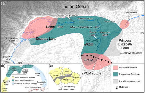
Figure 1. (a) Study area showing various terranes of Enderby Land and Princess Elizabeth Land of East Antarctica along with the outcrop distribution and the interpreted age of the crustal rocks and location of Pan-African overprinting. Abbreviations: sPCM, Southern Prince Charles Mountains; nPCM, Northern Prince Charles Mountains. Existing interpretation of the sPCM suture is also shown (after Mulder et al., Citation2019). (b) Inset map shows the distribution of the major geological terranes of the Antarctica and their affinities with other parts of Gondwana. (c) East Gondwana configuration and Kuunga orogeny, which is the interpreted orogenic belt along which the ancient Indian and East Antarctica terranes were amalgamated.
The Antarctica geological provinces are covered with thick ice sheets, and only <3% of the rocks are exposed as inland nunataks and coastal outcrops (). Aerogeophysical methods, particularly aeromagnetic surveys, have been very useful in delineating the subsurface structure of different geological domains based on different rock compositions despite the thick ice cover (Aitken et al., Citation2016; Ferraccioli et al., Citation2011; Golynsky, Citation2007; Golynsky, Chiappini, et al., Citation2006; Golynsky, Golynsky, et al., Citation2006; Golynsky, Masolov, et al., Citation2006; McLean et al., Citation2008, Citation2009). The delineation of structural elements such as the identification of major faults and lineaments along with crustal models provide better insights towards understanding the sub-ice sheet crustal structure. Previous aeromagnetic studies over East Antarctica (Golynsky, Citation2007; Golynsky, Chiappini, et al., Citation2006) divided East Antarctica into different crustal domains based on their distinct magnetic anomalies. Other studies have interpreted more detailed geological boundaries based on the interpretation of higher-resolution data collected within particular regions of East Antarctica (e.g. Golynsky, Golynsky, et al., Citation2006; Golynsky, Masolov, et al., Citation2006; McLean et al., Citation2009).
The similarities in the crustal evolution of the Proterozoic terranes of East Antarctica with its counterparts formed the basis to propose numerous models for the supercontinent configuration of the Paleo- to Mesoproterozoic Nuna (Henderson et al., Citation2014; Zhao et al., Citation2002), the Neoproterozoic Rodinia (Boger, Citation2011; Boger et al., Citation2001; Harley & Kelly, Citation2007; Kelly et al., Citation2002; Mikhalsky & Sheraton, Citation2011; Sheraton et al., Citation1996; Yoshida et al., Citation1992, Citation2003) and Gondwana (Aitken et al., Citation2016; Boger, Citation2011; Boger et al., Citation2001; Yoshida et al., Citation2003). Understanding the internal structure of various geological provinces of East Antarctica is critical in the reconstruction of East Gondwana and to establish geological correlations with its post-breakup counterparts. Geophysical interpretation of the Africa–Antarctica (Mueller & Jokat, Citation2019) and Australia–Antarctica (Aitken et al., Citation2016) sectors using relatively high-resolution datasets has provided geometric constraints that form the basis for plate reconstructions. By comparison, there is a dearth of geophysical studies to constrain the Indo-Antarctica sector. Antarctica and India have been mostly terrane-scale and are constrained by geochronology data, P–T histories of the various geological provinces on either side and direct geological correlations (Arora et al., Citation2020; Bose et al., Citation2011; Dasgupta et al., Citation2017; Dasgupta & Sengupta, Citation2003; Gupta et al., Citation2021; Mishra et al., Citation1999). However, neither detailed piercing points are identified, nor a crustal element map that shows the relationships with various geological provinces are available for a better understanding of the India and Antarctica reconstruction.
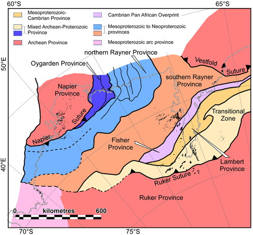
In this paper, we present a new province-scale geophysical interpretation of the East Antarctica part of Indo-Antarctica that spans Kemp Land, MacRobertson Land, Amery Ice Shelf, Enderby Land, and Princess Elizabeth Land (). These areas have been selected because they have similarities with the Eastern Ghats Mobile Belt and surrounding cratons of India (; Boger, Citation2011; Morrissey et al., Citation2016). Based on the aerogeophysical interpretation (), constrained by geochronology and geological studies, we separate East Antarctica into the Napier and Oygarden provinces, Northern and Southern Rayner provinces, Fisher Province, Lambert Province, Vestfold Hills Province, and Ruker Province (). Our geophysical interpretation of the Indo-Antarctica part of East Antarctica provides geophysical expressions of major rock packages, the distribution of geophysical-defined geological provinces and their boundaries. This new crustal element map will provide the required context to interpret local geological observations, and also provide potential stitching points to accurately reconstruct this part of East Antarctica with the newly identified structures over the Eastern Ghats Mobile Belt in India (Giri et al., Citation2022).
Figure 2. (a) Total magnetic anomaly map over the East Antarctica. Data are sourced from Antarctic Digital Anomaly Project (ADMAP2; Golynsky, Chiappini, et al., Citation2006). (b) Bouguer Anomaly map of the East Antarctica. Data are sourced from the AntGG project (Scheinert et al., Citation2016). All data are projected in Universal Polar Stereographic South (UPSS) and rotated 90° clockwise.
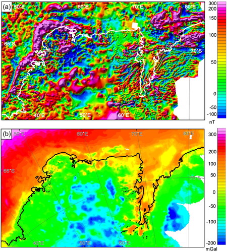
Figure 3. (a) Sun-shaded, reduced to the pole map of the total magnetic anomaly over the study area in East Antarctica. The solid white lines represent the interpreted tectonic element boundaries determined from the geophysical data. Abbreviations: AL, Amery Lineament; DML, Dronning Maud Land; nRP, Northern Rayner Province; sRP, Southern Rayner Province; FP, Fisher Province; LP, Lambert Province; RuP, Ruker Province; VH, Vestfold Hills. (b) Low-pass filtered map of the aeromagnetic anomaly map showing the distribution of regional-scale magnetic anomalies. The solid black lines represent the interpreted tectonic element boundaries determined from the geophysical data. Abbreviations: ACMMA, Antarctic Continental Margin Magnetic Anomaly; nPCM, Northern Prince Charles Mountains; sPCM, Southern Prince Charles Mountains. Data are sourced from Antarctic Digital Anomaly Project (ADMAP, Golynsky, Chiappini, et al., Citation2006; Golynsky, Golynsky, et al., Citation2006; Golynsky, Masolov, et al., Citation2006). Data were processed using Oasis Montaj (Seequent). Outcrops and nunataks are superimposed on the data. All data are projected in Universal Polar Stereographic South (UPSS) and rotated 90° clockwise.
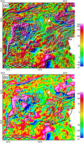
Figure 4. (a) Analytical signal map of the aeromagnetic anomaly map showing the distribution of magnetic causative bodies. AL, Amery Lineament. (b) Tilt derivative map of the aeromagnetic anomaly map, which shows the edges of the major anomalies. Solid white lines show the position of the tectonic element boundaries. Outcrops and nunataks are superimposed on the data. All data are projected in Universal Polar Stereographic South (UPSS) and rotated 90° clockwise.
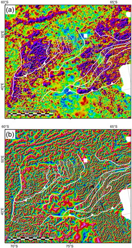
Figure 5. Sun-shaded, reduced to the pole images highlighting the locations of outcrops where the geophysical expression of the rocks is discussed. (a) Napier Province and adjacent part of the Northern Rayner Province. (b) Oygarden Province and adjacent part of the Northern Rayner Province highlighting the locations of outcrops where the geophysical expression of the rocks is discussed. Location of the areas are shown in . All data are projected in Universal Polar Stereographic South (UPSS) and rotated 90° clockwise.
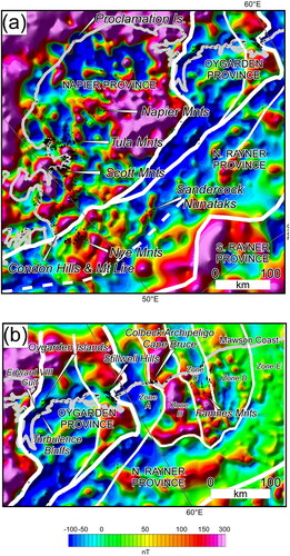
Figure 6. Sun-shaded, reduced to the pole images highlighting the locations of outcrops where the geophysical expression of the rocks is discussed. (a) Northern Prince Charles Mountains (Southern Rayner Province) and the adjacent part of the Fisher Province. Location of continuous magnetic anomalies and the interpreted position of regional fold axial traces are shown. (b) Lambert Province, Transition Zone and Ruker Province. (c) Southern Rayner Province, Fisher Province and Lambert Province along the eastern Amery Shelf. (d) Locations of the maps in and . All data are projected in Universal Polar Stereographic South (UPSS) and rotated 90° clockwise.
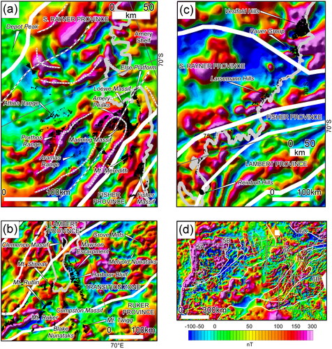
Figure 7. Tectonic element map interpretation of the geophysical data showing the location of the major province boundaries and the interpreted suture zones at the boundaries of the Archean provinces. The tectonic element map reveals that the Meso- to Neoproterozoic provinces form a series of linear to curvilinear belts.
Data and methodology
The aeromagnetic map of the study region in East Antarctica was prepared from the Antarctic Digital Anomaly Project (ADMAP2) data compilation (Golynsky, Bell, et al., Citation2013; Golynsky, Chiappini, et al., Citation2006; Golynsky, Golynsky, et al., Citation2006; Golynsky, Masolov, et al., Citation2006; Golynsky et al., Citation2018). The data coverage is variable with very sporadic coverage for the interior of Enderby Land (∼30–40 km spacing), whereas the continental margins are adequately covered (7 km spacing; Golynsky, Bell, et al., Citation2013). These ADMAP2 data were gridded at an interval of 5 km (). Despite the overall sparseness of the data, it is sufficient to provide important insights toward understanding the subglacial geological structures at a terrane-scale. Magnetic datasets were processed for diurnal correction and IGRF correction before being reduced to the pole (RTP) in preparation for interpretation (). The RTP data were then further processed to enhance the data. A low-pass filter was applied to image the deeper sources of the anomalies, allowing better correlation of anomalies for datasets with different resolutions (). The analytical signal map (Nabighian, Citation1972) is prepared to glean into the distribution of the causative bodies of magnetic anomalies () by identifying the total envelope of magnetisation from magnetic source bodies. The tilt derivative (TDR) map (Miller & Singh, Citation1994) is prepared to see the enhancement in the edges of the anomalies, and also for better visualisation of the anomalies along the major boundaries ().
The gravity datasets were downloaded from the ‘Gravity and Geoid in Antarctica’ (AntGG) project (Scheinert et al., Citation2016). These data are a compilation of airborne, ground, and shipborne surveys along with the satellite gravity resulting in ∼73% coverage over Antarctica at a 10 km grid interval (Scheinert et al., Citation2016) with grid values comprising of both free-air and complete Bouguer anomaly data. The complete Bouguer anomalies were derived by using the bedmap2 grid (Fretwell et al., Citation2013) with standard densities of 2670 kg/m3 for subglacial rocks, 917 kg/m3 for ice cover and 1025 kg/m3 for the water (Scheinert et al., Citation2016). The complete Bouguer anomaly map prepared from this grid is shown in .
The gravity and magnetic methods are sensitive to the density and magnetisation variations and mineral composition of various rock types. Potential field geophysical methods are able to delineate subsurface structural links in polydeformed provinces and glean the crustal architecture at depth (Aitken & Betts, Citation2008, Citation2009; Direen et al., Citation2005; Stewart et al., Citation2009; Stewart & Betts, Citation2010), which is pertinent in ice-covered regions. One of the challenges with interpreting aeromagnetic data at a continental scale is the highly variable spatial resolution (i.e. flight line spacing) and the variable thickness of ice sheet cover (see Golynsky, Bell, et al., Citation2013; Golynsky et al., Citation2018, for flight line details). Consequently, different parts of the study area will be imaging different wavelengths and amplitudes in the data, and survey boundaries may appear as breaks in the magnetic data. We have considered these in our interpretations.
The combined gravity and magnetic data analysis helped us to identify the structural features including litho-tectonic boundaries, faults and suture zones, which enhances the potential correlations between East Antarctica and its counterparts during the Proterozoic supercontinent cycles. Published geochronology data were used to constrain the age of the geological provinces and the timing of major tectonic episodes.
Geophysical signatures over the East Antarctica
The density of the aerogeophysical data does not allow for the correlation of individual geological units but nevertheless allows for the mapping of terrane-scale subsurface geology beneath Antarctic ice sheets. A combined analysis of RTP (), a low-pass filter of the RTP data (), analytical signal () and TDR () maps together in correlation with limited rock outcrops are used to define geological domains, which provided new insights for the identification and distribution of provinces with distinct geophysical signatures. When combined, these data allow for elucidation of the first-order geological evolution, which otherwise could not be determined.
Napier Province
The rock exposures in the Archean to Paleoproterozoic Napier Province are dominantly composed of tonalitic to granitic orthogneiss with intercalated mafic and ultramafic rocks and layered metasedimentary rocks, including banded iron formations of the Napier Complex (Sheraton, Citation1987).
The distinct geophysical expression of the Napier Province reveals that it has an ovoid shape and with a dimension of ∼550 km in length and ∼300 km in width ( and ). The sources of the magnetic signals of the Napier Province have been outlined in Golynsky et al. (Citation1996). Low magnetic responses within the province generally correlate with exposures of granitic and metasedimentary rocks that are exposed in the Tula and Napier mountains () in the central part of the province (Golynsky et al., Citation1996), and in the northeast coast (e.g. Proclamation Island; ). Many of these low magnetic zones are characterised by irregular edges that locally truncate linear (albeit commonly discontinuous) high magnetic anomalies (). This pattern suggests these regional magnetic lows represent irregularly shaped or coalescing granitic plutons. Relatively linear, high magnetic anomalies in the vicinity of the Scott Mountains () correlate with exposures of orthogneiss and localised banded iron formation (Funaki et al., Citation2006; Golynsky et al., Citation1996). A significant regional magnetic anomaly extends from Edward VIII Gulf along the eastern edge of the Napier Province against regional low responses associated with the Oygraden Group in Kemp Land (). Golynsky et al. (Citation1996) proposed that this large regional anomaly is associated with the crustal reworking of the Napier Province cratonic margin sourced from Archean granulites and metasedimentary rocks that contain banded iron formations. A prominent offshore east–west-trending, continuous magnetic anomaly characterises the northern and northwestern parts of the Napier Province. This anomaly is part of the Antarctic Continental Margin Magnetic Anomaly (ACMMA; ), which is interpreted as a continental crustal discontinuity (Golynsky, Ivanov, et al., Citation2013; Golynsky et al. Citation1996) but also may reflect transitional crust with abundant mafic intrusions associated with Gondwana breakup.
The southern boundary of the Napier Province with the Rayner Province is characterised by a significant and rapid decrease in the magnetic response in the RTP, analytical signal and low-pass filter magnetic map ( and ), and an obliquity in the north-northeast trends of the magnetic anomalies (e.g. Nye Mountains, and ).
Oygarden Province
The Oygarden Province is located to the immediate east and southeast of the Napier Province and is named after the Oygarden Group, which is exposed in Kemp Land (). The Oygarden Group comprises reworked granulite facies, felsic and mafic orthogneiss (Kelly et al., Citation2002, Citation2004; Sheraton, Citation1987). Geological evidence has suggested that the boundary between the Napier Province and the Oygarden Group is transitional (Kelly et al., Citation2002); however, the aerogeophysical data shows a clear boundary that is characterised by a decrease in the onshore RTP and analytical signal of the magnetic response of the Oygarden Province ( and ). The boundary between the Napier and Oygarden provinces is approximately northeast to north-northeast-trending (). The Oygarden Province is generally characterised by relatively low magnetic responses, suggesting the overall package is less magnetic than the surrounding Napier and Rayner provinces ( and ). Several moderate amplitude magnetic anomalies within the Oygarden Province are east-northeast-trending and truncated by north–south-trending faults, which suggests the Oygarden Province is an ∼ north–south fault-bounded domain that is orthogonal to the Kemp Land continental margin (). The offshore region of the Oygarden Province is characterised by an increase in magnetic response () and Bouguer gravity anomalies, which might be related to the younger ACMMA () overprint related to Gondwana breakup (Golynsky, Ivanov, et al., Citation2013).
The Oygarden Province pinches out to the southwest to the immediate east-northeast of the Nye Mountains of the Rayner Province (). There are limited outcrops of the Oygarden Province. In the vicinity of the Oygarden Islands () where felsic and mafic orthogneiss are the dominant lithologies (Kelly et al., Citation2002), there is a moderate east–west-trending magnetic anomaly, which does not represent the overall low magnetic response of the Oygarden Province. The Turbulent Bluff () exposures along the eastern edge of the King Edward Gulf also include orthogneiss that yields ages of ca 3100 and ca 2500 Ma (Clarke, Citation1987, cited in Kelly et al., Citation2000). These orthogneisses are characterised by deep low magnetic responses that typify large tracts of the eastern and southern parts of the Oygarden Province () and are distinct from the high magnetic responses of the Napier Province and the western Oygarden Province.
The western Oygarden Province is separated from the eastern parts of the province by a north–south-trending domain with prominent magnetic highs ( and ). Further to the south, this fault merges with an east-northeast-trending structure that is interpreted as the boundary between the Oygarden Province and the Rayner Province to the east and south (). The tilt derivative data () shows that magnetic anomalies in the southern termination of the eastern Oygarden Province are northeast- to north-trending and truncate east–west-trending anomalies of the western parts of the province. To the north of the Kemp Land coastline the offshore tilt derivative anomalies are east-northeast-trending or irregularly shaped (). Between the magnetic highs is a zone of low magnetisation, which corresponds to polydeformed exposures of dominantly mafic and felsic orthogneiss (ca 3650–3460 Ma), subordinate charnockite and the metasedimentary rocks (Halpin et al., Citation2007).
Overall, the Oygarden Province is discontinuous and pinches out to the southwest, is locally restricted to the eastern margin of the Napier Province in Kemp Land () and does not extend into the interior of East Antarctica ().
Rayner Province
The exposed Rayner Province generally extends from the Kemp Land through MacRobertson to the Lambert Rift, along the east Antarctic coast and inland to the southern Prince Charles Mountains (; Halpin et al., Citation2005; Morrissey et al., Citation2016). Several isolated exposures in the Nye Mountains, Condon Hills, and Mt Lire () occur to the immediate south of the Napier Province (), suggesting the Rayner Province extends all the way to Casey Bay (). The Rayner Province comprises mafic granulite, felsic orthogneiss, metapelites, charnockite (Halpin et al., Citation2005, Citation2007) and granite rocks that record multiple crustal reworking events associated with the Grenville and Pan-African orogens (Boger, Citation2011; Halpin et al., Citation2013; Kelly et al., Citation2002; McLean et al., Citation2008; Morrissey et al., Citation2016). This province is differentiated from the Oygarden Province because of the absence of Archean-aged rocks (Kelly et al., Citation2002). We have separated the Rayner Province into the Northern and Southern Rayner provinces based on differences in their magnetic response ().
Northern Rayner Province
The Northern Rayner Province is an arcuate domain that is characterised by a diverse magnetic expression in the aerogeophysical data. Along Kemp Land and western MacRobertson Land, where the Northern Rayner Province intersects the Antarctica coastline it is characterised by alternating zones of low magnetic signal and high and moderate responses (labelled as zones A–E; and ). These zones are interpreted to be bound by north–south-trending faults that locally truncate magnetic anomalies. Magnetic anomalies within these zones are north-northeast- to north-trending. Magnetic zones to the immediate east and west of Mawson Station (zones B, C and D; ) do not extend far into the interior of MacRobertson Land and are truncated by a series of anastomosing ∼ east–west-trending anomalies, which we interpret as regional faults that bound the northern margin of zone E ( and ). Zone B is characterised by a high magnetic signal, and zone C is generally heterogeneously magnetised with a low response along the coast and offshore, and is more magnetised onshore (). Both zones B and C comprise exposures of felsic and metasedimentary gneisses of the Colbeck Gneiss, which is exposed along the Mawson Coast (Halpin et al., Citation2007). The Colbeck Gneiss is extensively intruded by the Mawson Charnockite, which dominates the outcrops in the Framnes Mountains (; Clarke, Citation1988). The analytical signal map shows clusters of high magnetic anomalies in zones B, C and D (), indicating the presence of the magnetic source bodies, likely charnockite exposed along the Mawson Coast and in the interior mountains. U–Pb geochronology analysis of these charnockites yields dates between ca 1000 and ca 940 Ma (Grew et al., Citation1988; Halpin et al., Citation2007).
Zone A forms a north–south zone of low magnetic response () adjacent to the Oygarden Province. This zone extends into Enderby Land to the immediate south of the Oygarden Province (), where it is characterised by a generally low magnetic signal in the RTP and the low-pass filter maps (), with some isolated high-amplitude magnetic anomalies that trend in a northeast-direction subparallel with the zone boundaries (). This domain of low magnetic response is coincident with a moderate to strong, heterogeneous analytic signal response, suggesting the presence of magnetised source and possibly remnant magnetisation. The analytic signal response generally reduces to the southwest (), but there is a general correlation between high-amplitude magnetic responses and the positive analytic signal response. The low magnetic response of zone A corresponds with exposures at Cape Bruce (), which contain pelitic gneiss, felsic orthogneiss, and felsic plutons (Halpin et al., Citation2005, Citation2007). In the western parts of the Northern Rayner Province, there is an abrupt change in the magnetic response, which becomes increasingly more magnetic. Individual magnetic anomalies in this region of relatively high magnetism trend in a northeast orientation, or locally have irregular shapes. Several of these anomalies coincide with the Nye Mountains (Sheraton et al., Citation1980) and Mount Condon (), which comprise tonalitic to granitic and mafic orthogneiss (Ravich & Kamenev, Citation1975), metapelitic gneiss and minor marble (Sheraton et al., Citation1980). Charnockitic gneiss (Horie et al., Citation2016) at Sandercock Nunataks coincides with relatively narrow northeast-trending magnetic anomalies (). The magnetic response of these rocks suggests similarities with the rocks in the eastern parts of the Northern Rayner Province (; Mikhalsky et al., Citation2017). The western boundary of the Rayner Province is interpreted to extend offshore of Dronning Maud Land ( and ).
To the east of Mawson Station in zone E, the Northern Rayner Province () is characterised by a more subdued and relatively homogeneous magnetic signal with low to medium amplitude and relatively long-wavelength magnetic anomalies (). The absence of significant analytical signal anomalies in this part of the Northern Rayner Province suggests it represents a different litho-tectonic domain compared with the zones A, B, C and D (). Rare outcrops include Mount Rivett, which coincides with domains of irregular and anomalously high magnetisation along the Mawson Coast. This exposure contains mafic granulite, and migmatite (Sheraton, Citation1983). The boundary between Kemp Land and western MacRobertson Land is characterised by relatively narrow curvilinear magnetic anomalies ( and ) that change orientation from north-northwest–south-southeast along the Mawson Coast to east-northeast in the interior. This boundary continues into the interior of Rayner Province in Enderby Land. The boundary with the Southern Rayner Province is also curvilinear and subparallel with mapped faults in the interior of the domain (). The isolated Depot Peak outcrop () comprises metapelitic gneisses that are intruded by sheeted granites (Stüwe & Hand, Citation1992) and coincides with a subdued magnetic signal that characterises zone E (). Further to the southwest, the magnetic signal of the zone becomes more heterogeneous, and several prominent high magnetic anomalies with east–west to west-southwest trends stand out in a broad zone of low magnetisation. There are no constraints for the sources of these signals.
Southern Rayner Province
The data in the northern and southern Prince Charles Mountains are higher resolution (5 km spacing; Golynsky, Bell, et al., Citation2013; e.g. PCMEGA survey, Damaske & McLean, Citation2005), and ice cover is less, with a relatively high density of exposed basement (; McLean et al., Citation2009). Consequently, the magnetic data image has greater geological detail (). Several authors have referred to this region with high resolution data as the Beaver Domain (Golynsky, Masolov, et al., Citation2006; McLean et al., Citation2009). Along the western flanks of the Lambert Rift, the Rayner Province is characterised by an increased analytical signal response (). Because of the distinct magnetic signal of the northern Prince Charles Mountains (nPCM), we have separated it from the Rayner Province in MacRobertson Land and herein refer to this domain as the Southern Rayner Province, which includes the extension of well-defined magnetic anomalies of the nPCM extending further to the southwest under thicker ice cover, where they merge into longer-wavelength magnetic anomalies ().
The boundary between the Northern Rayner Province and the Southern Rayner Province is defined by a marked increase in magnetic response (), and truncation of northeast-trending high-amplitude anomalies, in the Southern Rayner Province. Overall, the magnetic data show that the Southern Rayner Province has a similar architecture to the Northern Rayner Province; however, the internal architecture is more complex. At the northern extent of the province, north-northeast-trending magnetic anomalies extend offshore where they intersect the Prydz Bay coastline (). In MacRobertson Land, anomalies become west-southwest-trending, parallel with the orientation of linear anomalies in the northern Prince Charles Mountains (nPCM). The magnetic responses of MacRoberton Land are separated by those in the nPCM by the discontinuous, regional east-northeast- to east–west-trending Amery Lineament (; Golynsky, Masolov, et al., Citation2006; McLean et al., Citation2009). This lineament is interpreted to be sourced from deep-seated intrusive rocks that crosscut the structural grain of the Southern Rayner Province and therefore are interpreted to be relatively young (McLean et al., Citation2009).
The extensive exposures of the nPCM allow for a good correlation between magnetic anomalies and source rocks (Golysky, Masolov, et al., 2006; McLean et al., Citation2009). The northern sections of the nPCM are characterised by a relatively low amplitude and smooth magnetic responses associated with outcrops of high-grade metasedimentary gneiss along the Athos Ranges (; Golynsky, Masolov, et al., Citation2006). The moderate magnetic anomalies suggest the presence of a regional west-southwest-trending fold with a southern limb that strikes to the west-southwest and a northern limb that strikes north–south to north-northeast (), which becomes truncated by the northeast-trending boundary with the Southern Rayner Province. Magnetic gradients in the hinge zone suggest the fold is an east-plunging synform (). This fold geometry is also apparent in the highly curvilinear west-southwest to southwest-trending magnetic anomalies that coincide with the Porthos Ranges (). Termed the Porthos series (Boger et al., Citation2001; McLean et al., Citation2009), these west-southwest-trending, high-amplitude, anomalies are associated with felsic orthogneiss, pelitic and calc-silicate gneiss, high magnetic susceptibility charnockites (Golynsky, Masolov, et al. Citation2006; Hensen et al., Citation1997), which are preserved on the southern limb of the regional synform. This package of rocks extends to the southern boundary of the southern Rayner Complex with the Fisher Province ( and ). Several prominent low-amplitude anomalies parallel with the Porthos series anomalies relate to metapelitic gneiss exposed in the Aramis Ranges (; Boger et al., Citation2000; Morrissey et al., Citation2016) and have been interpreted to represent a distinct rock package (Golynsky, Masolov, et al. Citation2006). These anomalies become more subdued beneath the Lambert Rift but nevertheless reveal another fold closure. A large positive ‘half-moon’-shaped anomaly, coincident with the Amery Peaks, Loewe and Manning massifs (), may represent the hinge zone of a northeast-plunging antiform. These orientations are consistent with the D3 upright folds of Boger et al. (Citation2000) and formed during Neoproterozoic ∼ north–south shortening. To the northeast, the Southern Rayner Province appears to bifurcate beneath Prydz Bay around the highly magnetised Archean Vestfold Hills province (). To the south of the Vestfold Hills province, the high amplitude magnetic anomalies of the Southern Rayner Province are comparable to east-west trending anomalies in the nPCM. To the east of the Vestfold Hills province moderate amplitude anomalies trend north-northeast to north-south ().
The resolution of the aerogeophysical data is reduced to the southwest of the nPCM, and the ice thickness increases. The anomalies are characterised by longer wavelengths and reduced amplitudes (). Regional high- and low-amplitude magnetic anomalies identified in the nPCM can be extended to the southwest toward Enderby Land. Anomalies in the southern part of the Southern Rayner Province are southwest-trending, whereas in the northern part of the province, they change to a northeast-trend, thus defining a regional synformal fold hinge that can be traced back to the Athos Ranges. Regional low-amplitude anomalies also fold around this hinge zone. This suggests that the Southern Rayner Province is defined by a regional synformal with an antiformal pair preserved in the nPCM ().
The western extension of the Southern Rayner Province is characterised by their generally high- to moderate-amplitude anomalies near Dronning Maud Land ( and ). In this part of the province, there is a strongly stippled magnetic texture and distinct intersecting north-northeast- and east-northeast-anomaly trends that are not apparent in the rest of the province (). The Ruker Province is positioned to the immediate south of this section of the Southern Rayner Province. The intersecting anomalies may be related to the intersection of the Ruker-Southern Rayner Province boundary and a younger northeast-trending Pan-African overprint.
Fisher Province
The Fisher Province is located to the south of the Southern Rayner Province () and comprises felsic orthogneiss, metapelitic gneiss, charnockite and stratified felsic gneiss, and thick sequences of mafic and felsic schist interpreted as metavolcanic rocks with minor mafic and ultramafic layered rocks (Mikhalsky et al., Citation1999; Mikhalsky & Sheraton, Citation2011; Van Leeuwen et al., Citation2019). The province is interpreted as a continental magmatic arc owing to the presence of calc-alkaline magmatism and isotopic analysis of intrusive rocks (ca 1300–1190 Ma; Mikhalsky et al., Citation1999). The Fisher Massif () comprises exposures of mafic and felsic intrusive and volcanic rocks (Van Leeuwen et al., Citation2019) that coincide with linear, southwest-trending, high-amplitude magnetic trends. Felsic rocks are characterised by low magnetic susceptibilities (Golysky, Masolov, et al., 2006) and exposures of paragneiss (e.g. Mount Meredith, , Kinny et al., Citation1997) and are interpreted as the source of low-amplitude anomalies in the Fisher Province.
In the nPCM, the boundary between the Fisher Province and the Southern Rayner Province is defined by truncations of north- to northeast-trending anomalies of the Fisher Province by west-southwest-trending anomalies in the Southern Rayner Province ( and ). The aerogeophysical expression of the Fisher Province shows it has a heterogeneous expression. The province has an overall southwest trend and has a limited strike length to the southwest where it terminates against a transitional domain ( and ). Internal high-magnitude anomalies in the southwest are north–south to north-northeast-trending at a high angle to the province boundaries. Towards the nPCM, the anomalies are southwest-trending parallel with the province boundary. The northeast continuation of the Fisher Province is less clear beneath the Lambert ice shelf ( and ) where the magnetic signal is masked ( and ), owing to an increase in distance to the magnetic source as a result of ice cover and basinal sedimentation. We interpret the Fisher Province to extend into the eastern Amery Ice Shelf and southwest Prydz Bay ( and ) and include several exposures along the coast of Princess Elizabeth Land Bay (e.g. Reinbolt Hills, ). These exposures of are dominantly Mesoproterozoic felsic and mafic gneiss, and migmatitic paragneiss intruded by Neoproterozoic charnockite (Liu et al., Citation2014). These small and isolated outcrops are coincident with a heterogeneously magnetic domain characterised by irregular and trendless high-amplitude anomalies (). A correlation between these rocks and Fisher Province rocks in the nPCM is supported by their arc-related geochemical affinities (Liu et al., Citation2014; Mikhalsky & Sheraton, Citation2011) and their Mesoproterozoic age. The eastern continuation of the Fisher Province is defined by a smooth low magnetic signal that trends east–west (). This wide anomaly lies to the immediate south of the Amery Lineament and crosses the Prydz Bay coastline just to the south of Larsemann Hills (). There are no geological constraints for this interpreted part of the Fisher Province.
Lambert Province
The southern Prince Charles Mountains (sPCM) is a mix of the Lambert and Ruker provinces (Corvino et al., Citation2008; Phillips et al., Citation2006, Citation2009). These two domains have been lumped as the Mawson Domain by McLean et al. (Citation2009). The Lambert Province contains Archean–Paleoproterozoic orthogneiss, metasedimentary succession and felsic dykes of the Lambert Complex (Phillips et al., Citation2009). The northern part of the province has comparable evolution to the Rayner Province, whereas the southern part of the terrane has a strong Pan-African overprint (Boger & Wilson, Citation2005; Phillips et al., Citation2009). Magnetic anomalies within the Lambert Province are similar in character to the Southern Rayner and Fisher provinces. They are linear and trend northeast–southwest in the sPCM, north–south beneath the Lambert ice shelf, and north-northeast- to east–west in Prince Elizabeth Land (). The Lambert Province terminates against the transitional boundary in the southwest. The boundary with the Fisher Province to the north is characterised by the abrupt truncation of Fisher Province anomalies in the sPCM, and truncation of Lambert Province anomalies in Princess Elizabeth Land. In the sPCM, moderate magnetic responses are associated with paragneiss (e.g. Mount Creswell), whereas felsic orthogneiss, mafic gneiss and (semi-)pelitic gneiss from the Clemence Massif (Corvino et al., Citation2005) are associated with ∼ north–south-trending, high-amplitude, linear magnetic anomalies ().
The northeastern part of the Lambert Province (Princess Elizabeth Land) is generally characterised by prominent curvilinear and subparallel magnetic anomalies that trend north-northeast to east–west ( and ). High-amplitude anomalies with irregular shapes (Princess Elizabeth Land) truncate linear anomalies and are interpreted to represent late-stage intrusions of unknown age ( and ).
Ruker Province
The Archean Ruker Province comprises orthogneiss and intercalated metasedimentary rocks, and the overlying quartzite and pelite, and highly magnetised banded iron formation (McLean et al., Citation2008), which are predominantly exposed in the sPCM. These packages are unconformably overlain by the metasedimentary rocks of the Sodruzhestvo Group (Phillips et al., Citation2005, Citation2006). Detailed magnetic interpretation of the PCMEGA survey (Damaske & McLean, Citation2005; McLean et al., Citation2008) reveals that the rock packages of the Ruker and Lambert provinces are interleaved, suggesting the boundary between the two domains is likely to be transitional ( and ). Our interpretation reflects this, and we have demarcated a transitional zone between the Lambert and Ruker provinces ( and ). The interleaved character of this domain and the proximity to proposed suture zones make interpretation of the aerogeophysical data in this region challenging (e.g. Golynsky, Golynsky, et al., Citation2006; Golynsky, Masolov, et al., Citation2006).
The transitional zone between the Ruker and Lambert provinces is characterised by magnetic anomalies that trend approximately parallel with the Lambert Province. The most prominent of these anomalies are west-southwest- to east–west-trending and have been interpreted to reflect Ruker Group (banded iron formation and tholeiitic basalts), which are exposed at Mt Ruker (; McLean et al., Citation2009; Mikhalsky et al., Citation2006). These highly magnetised zones are also evident in the analytical signal map as a prominent magnetic source (). In the sPCM, linear, moderate magnetic anomalies are sourced from metasedimentary rocks of the Archean Tingay Group. Irregular moderate to high magnetic anomalies correlate with the orthogneiss of the Lambert Complex (McLean et al., Citation2008), which are exposed at Mount Stinear and Mount Rymill (). Long-wavelength magnetic lows coincide with outcrops of Neoproterozoic sedimentary cover (Sodruzhestvo Group) at Mount Rubin, and to the immediate south of Cumpston Massif (; McLean et al., Citation2008). These magnetic lows extend to the west along the boundary with the Ruker Province, and to the east of the southern Mawson Escarpment ().
The Mawson Escarpment represents a large exposure of Archean to Neoproterozoic rocks that almost extends across the width of the transition zone ( and ). Archean granite gneiss exposed along the southern Mawson Escarpment is moderately magnetic, whereas post-Archean granite gneiss is coincident with an increase in magnetic response (Boger & Wilson, Citation2005). North of Harbour Bluff (), Archean grey gneiss, Proterozoic supracrustal rocks, granite gneiss and Cambrian granites (Corvino et al., Citation2005) are associated with a large, irregular-shaped, negative magnetic anomaly (). It is not clear how extensive the rocks of the Mawson Escarpment are, as their associated anomalies are laterally discontinuous, and this is reflected in previous magnetic interpretations in this area (e.g. McLean et al., Citation2009).
The Grove Mountains () are exposed in the eastern part of the transition zone () to the east of the Mawson Escarpment. This diffuse zone of outcrops comprises migmatitic gneiss, tonalitic and granitic gneiss, paragneiss and mafic schists, and rare calc-silicates (Golynsky, Golynsky, et al., Citation2006; Liu et al., Citation2003). A detailed aeromagnetic interpretation of the Groves Mountains is presented in Golynsky, Golynsky, et al. (Citation2006). Generally, the region can be separated into three broad east-northeast-trending magnetic zones (). The northernmost zone is characterised by a low-amplitude smooth magnetic signal that has been interpreted to indicate the presence of metasedimentary rocks (Golynsky, Golynsky, et al., Citation2006). This domain aligns with the low magnetic zone in the northern Mawson Escarpment, so it is possible they are equivalents (). A central zone is characterised by moderate magnetic responses and related to felsic and granitic gneiss interpreted as the Grove sub-unit (GrSU: ) by Golysky, Golynsky, et al. (Citation2006). Zircon from granitic gneisses from the Melvold Nunatak () has Neoproterozoic cores and Cambrian metamorphic rims. The southernmost zone is characterised by a high-amplitude magnetic response (Gale sub-unit: GaSU, ; Golynsky, Golynsky, et al., Citation2006). The source of these high-amplitude magnetic anomalies correlates with large granitoid and metapelitic rocks of the Gale Escarpment and the Davey Nunataks (), which have a strong Pan-African imprint (Liu et al., Citation2003). This zone has a similar magnetic response and is along strike to magnetic anomalies along the southern Mawson Escarpment (), possibly suggesting they represent the same rocks (with the implication they are Ruker Group equivalents). To the west of the sPCM, the transitional zone becomes increasingly less magnetic, reflecting the increased thickness of the ice cover and the prevalence of the non-magnetic Sodruzhestvo Group ().
The Ruker Province (sensu stricto) has a heterogeneous magnetic response, with a prominent long-wavelength magnetic anomaly that is surrounded by heterogeneous magnetic responses with prominent north–south to north-northeast-trending magnetic anomalies, which are approximately orthogonal with the boundary between the Ruker Province and the transitional zone, as well as the regional structural grain of the Rayner, Fisher and Lambert provinces. This trend is a distinguishing feature of the Ruker Province. Mt Twigg and the Blake Nunataks () expose tonalitic and trondjehmitic gneiss (Mikhalsky et al., Citation2006), similar to the southern Mawson Escarpment and Cumpston Massif (). Their magnetic response is also very similar. Mt Twigg is located at the northern tip of a large, high-amplitude, stippled textured, sub-circular anomaly ( and ). The Blake Nunataks are characterised by discontinuous moderate to high anomalies similar to the southern Mawson Escarpment ().
Vestfold Hills and Rauer Group
The Vestfold Hills and Rauer Group are located at the eastern end of the Prydz Bay coast further east of Larsemann Hills (). The Vestfold Hills Province is dominated by the Neoarchean (ca 2520 Ma) granodiorites, tonalitic orthogneisses and pyroxene granulites, and metavolcanic rocks and semi-pelitic rocks (Harley, Citation1993), which record magmatic accretion crust formation events between ca 2520 and 2480 Ma (Harley & Kelly, Citation2007). These rocks had undergone granulite facies metamorphosed at ca 2500 Ma. Grenvillian and Pan-African metamorphic ages are absent in this terrane (Clark et al., Citation2018; Hoek & Seitz, Citation1995; Mikhalsky et al., Citation2019). These rocks are intruded by extensive dyke arrays of Meso- to Neoproterozoic age (Clark et al., Citation2012; Harley & Kelly, Citation2007; Liu et al., Citation2021).
The Rauer Group () is a composite terrane that comprises a package of >3270 Ma and ca 2820–2800 Ma tonalitic orthogneisses (Kinny et al., Citation1993), as well as pelite, marble and quartzite (Mather Paragneiss, Harley et al., Citation1998). These Archean rocks are interleaved with ca 1030–1000 Ma felsic to mafic intrusive supracrustal rocks (Kinny et al., Citation1993) that underwent high-grade metamorphism during the Rayner Orogeny at ca 1000 Ma and again at ca 510 Ma (Harley et al., Citation1998; Harley & Buick, Citation1992; Liu et al., Citation2021).
The Vestfold Hills and Rauer Group are characterised by high to very high magnetic anomalies of ∼200–300 nT, although there are several areas with relatively low response in the interior of the domain, which correspond to exposures at Vestfold Hills. The analytical signal map () also shows the dense distribution of the magnetic source bodies in this region. The RTP and tilt derivative maps ( and ) of the region is characterised by relatively continuous high amplitude magnetic anomalies that coincide with rocks exposed in Vestfold Hills and the Rauer Group. These anomalies abruptly terminate at the boundary with the Southern Rayner Province, where there is a change orientations of magnetic anomalies ( and ).
Discussion
In regions of exposure, there has been significant progress in understanding the evolution of the Indo-Antarctica part of East Antarctica (e.g. Boger et al., Citation2000; Clark et al., Citation2018; Clarke, Citation1988; Corvino et al., Citation2005; Halpin et al., Citation2005, Citation2013; Kelly et al., Citation2004; Liu et al., Citation2003, Citation2013, Citation2021; Mikhalsky et al., Citation1999, Mikhalsky & Sheraton, Citation2011; Morrissey et al., Citation2016; Sheraton, Citation1983; Stüwe & Hand, Citation1992; Van Leeuwen et al., Citation2019). Owing to the extensive ice cover of East Antarctica, connecting the different rock exposures has not been possible, and therefore uncertainty remains about the distribution of crustal domains and the location of major suture zones beneath the ice-covered interior. The aerogeophysical data of the region are of variable quality (Golynsky, Chiappini, et al., Citation2006; McLean et al., Citation2009) but are of sufficient resolution to provide constraints on the region’s long-wavelength signal and data, which allowed the creation of the crustal element map.
Crustal element map
The crustal element map is an important contribution to East Antarctica geoscience, as it provides a geometric framework to understand the vast amounts of geological data for the study area. The crustal provinces of East Antarctica show distinct magnetic signatures, which can reflect their lithological composition and ages, crustal reworking and metamorphic history (Damaske & McLean, Citation2005; Ferraccioli et al., Citation2005; Finn et al., Citation2006; Golynsky, Chiappini, et al., Citation2006; Golynsky, Golynsky, et al., Citation2006; Golynsky, Masolov, et al., Citation2006; Golynsky & Aleshkova, Citation2000; McLean et al., Citation2008, Citation2009). Although the sparse distribution of data over Antarctica limits the interpretation of the small-scale and shallow structures, the data do image longer-wavelength signatures in the geophysical data and the delineation of litho-tectonic domains that allow the construction of a crustal element map. In the construction of our crustal element map, we have attempted to honour all available geological and geochronological data for the study area. Our analysis of the magnetic data enabled determinations of crustal breaks and revealed that the structural grain of many of the crustal elements differs between regions. The crustal element map () shows the distribution and extent of provinces that have been gleaned by detailed geological and geochronological studies along the Mawson Coast and Prince Charles Mountains (Boger, Citation2011; Boger et al., Citation2000; Boger & Wilson, Citation2005; Halpin et al., Citation2005, Citation2013; Kelly et al., Citation2002; Kelly & Harley, Citation2005; Morrissey et al., Citation2016; Phillips et al., Citation2005, Citation2006, Citation2009).
The crustal element map reveals two first-order geometric patterns. The Oygarden Province, the Northern Rayner Province and part of the Southern Rayner Province are highly arcuate and are characterised by a 90° bend (). The Southern Rayner Province defines a transition and bifurcates around the margins of the Vestfold Hills Province. To the south, the Fisher Province, Lambert Province and the transitional zone are comparatively linear. These Fisher and Lambert provinces pinch out against the transitional zone, which itself becomes increasingly narrow and pinches out further east in the interior of Enderby Land ().
The high magnetic anomaly in the northern part of the Enderby Land marks the boundary of the Archean crustal block of the Napier Province, which suggests the craton has an overall ovoid map-view shape that extends offshore ( and ) at least to the ACMMA (). This is a relatively small province that is interpreted as a microcontinent. The Oygarden Province is a composite province of Mesoproterozoic rocks intercalated with the older rocks of the Napier Province (Halpin et al., Citation2007; Kelly & Harley, Citation2004), perhaps as a result of the Napier Province collision. Our aerogeophysical interpretations suggest that the Oygarden Group wraps around the southern part of the Napier Province, has a limited spatial extent and is truncated by a series of structures that form in the interior of the Northern Rayner Province. This relationship could suggest distribution of the Oygarden Province was spatially limited, or alternatively, large tracts of the province were tectonically removed during the Napier Province collision. The Rayner Province has been separated into two distinct provinces based on their geophysical character. These provinces are >1500 km in strike length and have a variable width. The provinces are narrowest in Enderby Land (∼300 km) and widest along the Mawson Coast (∼550 km). The increase in the magnetic response of the Southern Rayner Province is reflected in both the high-resolution and poor-resolution data, suggesting that it has a different crustal composition. The Fisher Province is interpreted as a ca 1300–1100 Ma (Mikhalsky et al., Citation1999; Liu et al., Citation2013) continental arc that separates and overprints the Lambert and Southern Rayner provinces. The narrow, 900 km long domain has a relatively low magnetic response that is consistent with a felsic igneous composition. The Lambert Province comprises older rocks than the Rayner and Fisher provinces, suggesting that it may represent a relatively narrow continental ribbon of comparable dimension to the Fisher Province in a forearc position. The Vestfold Hills is an Archean crustal element () that truncates Meso- to Neoproterozoic rocks of the Rayner Province. It has a Neoarchean core defined by the rocks of the Vestfold Hills and an interleaved zone represented by the Archean and Neoproterozoic rocks of the Rauer Group (Kinny et al., Citation1993), which likely represents a composite terrane.
Distribution of suture zones
There has been significant debate concerning the position and timing of the suture zones within East Antarctica (cf. Aitken et al., Citation2016; Boger, Citation2011; Daczko et al., Citation2018; Ferraccioli et al., Citation2011; Mulder et al., Citation2019) and their connectivity with each other and their counterparts in other Gondwanan continents. Our crustal element map reveals three suture zones that bound provinces of different ages.
Ruker suture
Boger et al. (Citation2001) proposed a suture that separated the southern Mawson Escarpment, which had rocks with Archean Ruker Province affinities, from the rocks of the northern parts of the escarpment, which comprised Proterozoic rocks of Lambert Province affinities (Phillips et al., Citation2006). This lateral extent and timing, and how it connects to the Kuunga suture, have been discussed in the recent literature (Boger et al., Citation2001; Corvino et al., Citation2011; Liu et al., Citation2014; Mikhalsky et al., Citation2017, Citation2020; Mulder et al., Citation2019). For example, Boger et al. (Citation2001) interpreted the suture zone in the southern Prince Charles Mountains, whereas Corvino et al. (Citation2011) preferred a location at the Fisher and Lambert provinces boundary. Our interpretation of the wide transitional suture zone in the southern Prince Charles Mountains may resolve these competing models by considering crustal interleaving over a wider suture zone where geological observation of ‘terrane boundaries’ represents the localised thrusts that accommodated the interleaving and terrane repetition. Terrane interleaving has been interpreted using higher-resolution magnetic data (McLean et al., Citation2008), which showed the repetition of Ruker Province and Lambert Province rocks bounded by major structures within this transition zone. Our crustal element map suggests the boundary between the Ruker Province and the transition zone lies to the south and is predominantly under ice cover. Here it is defined by a significant change in the geophysical anomaly trends across the boundary (). The geometry of the boundary is interpreted to be north-dipping, based on the position of the arc-related rocks of the Fisher Province and the structural observation in the southern Prince Charles Mountains (Boger et al., Citation2006; Corvino et al., Citation2011). Our data do not constrain where the Ruker suture zone extends to the east, and therefore its relationship with the Pan-African suture defined by the Mirny Fault remains unresolved. Our interpretation suggests that the Ruker suture extends toward Dronning Maud Land and is therefore a significant continental-scale boundary.
The relationship between the ca 950 Ma Sodruzhesto Group (Phillips et al., Citation2006), the Lambert Complex and the Archean to Paleoproterozoic rocks of the Ruker Group may provide insights into the timing of the collision between the Ruker Province and the Lambert Complex. The geophysical interpretation of McLean et al. (Citation2009) from within our transition zone suggests that the Sodruzhesto Group was deposited on the Ruker Group basement. This would suggest Ruker Province was accreted to the Lambert, Fisher and Rayner provinces before the deposition of the ca 950 Ma Sodruzhesto Group. If this timing were correct, it would suggest that the provinces of Indo-Antarctica provinces and Ruker Province were a coherent crustal block when they amalgamated with Australia–Antarctica during Pan-African times (Mulder et al., Citation2019), and the extension of this Pan-African suture must be further south (e.g. Gamburtsev suture zone: Ferraccioli et al., Citation2011).
Napier suture
The Napier suture separates the Napier Province from the Rayner Province (). The Oygarden Province represents a composite terrane comprising rocks that correlate with both the Napier and Rayner provinces (Kelly et al., Citation2004) and is interpreted to represent a suture zone of interleaved Archean and Proterozoic rocks (Kelly et al., Citation2002, Citation2004). Metamorphic analysis of UHT rocks from Kemp Land (Halpin et al., Citation2007; Kelly et al., Citation2002) reveals clockwise P–T–t paths suggesting collision tectonism between ca 960 Ma and ca 940 Ma during the Rayner Orogeny (Halpin et al., Citation2007; Kelly et al., Citation2004). Younger ages occur away from the nucleus of the Napier Province (e.g. in the Stillwell Hills of the Northern Rayner Province). In the interior of Enderby Land, there is a dearth of outcrops. However, a structural geology synthesis by Toyoshima et al. (Citation2008) shows a dominant northeast–southwest strike of the structural grain of the Rayner Province, parallel with magnetic anomalies from the same area, and interpreted fold axial traces are generally parallel with the Napier suture. We interpret the Napier suture to dip towards the interior of East Antarctica consistent with the dips of foliations (Toyoshima et al., Citation2008). Our crustal element map suggests that this collisional orogen is highly arcuate with a structural grain that wraps around the edges of the Napier Province (), and collision along this suture zone was a major influence on the arcuate geometry of crustal elements in northern Enderby Land, Kemp Land and MacRobertson Land.
Vestfold suture
A third suture zone has been interpreted at the boundary between the Archean rocks of the Vestfold Hills Province and the Southern Rayner Province (). In the aerogeophysical data, this boundary is characterised by a significant change in the magnetic response, where the Vestfold Hills Province is significantly more magnetic than the adjacent Southern Rayner Province. Interleaving of Archean and Proterozoic rocks within the Rauer Group likely occurred during the collision, and these rocks represent the wider suture zone. Our interpreted position of the suture is different from the interpretation in Peacock and Selway’s (Citation2016) magnetotelluric (MT) study, which imaged a boundary between the Vestfold Hills and the Rauer Group beneath the Sørsdal Glacier (). This boundary is also coincident with a significant boundary in the magnetic data (). Our preferred interpretation is that the MT-defined suture is an internal terrane boundary separating the Neoarchean rocks of Vestfold Hills from older Archean rocks of the Rauer Group (Harley & Kelly, Citation2007). Our interpreted suture location is more consistent with geochronology data that separate the Archean Vestfold Hills Province from Meso- to Neoproterozoic rocks of the Northern Rayner Province (Clark et al., Citation2012; Kinny et al., Citation1993). The strike of the suture is highly arcuate and bifurcates the Northern Rayner Province, suggesting collision at a high angle. See Tong et al. (Citation2019) for evidence of a clockwise P–T–t path at Larsemann Hills, which was interpreted as evidence for early collisional crustal thickening associated with the Rayner Orogeny followed post-orogenic extension and a Pan-African metamorphic overprint. These data suggest that the Rayner Orogeny between Enderby Land and Princess Elizabeth Land involved the collision of two distinct Archean provinces (Napier and Vestfold Hills).
Implication for plate reconstructions
This part of the East Antarctica continent remains somewhat controversial, as its position in supercontinent reconstructions is poorly resolved. Several researchers have suggested that the Indo-Antarctica was positioned adjacent to Austral-Antarctica during Rodinia times (e.g. Li et al., Citation2008), whereas others suggest a disconnection of the Indo-Antarctica and Austral-Antarctica until the amalgamation of Gondwana during the Pan-African event (e.g. Daczko et al., Citation2018). The absence of a crustal-architecture framework for this part of Antarctica means that the process responsible for amalgamation remains equivocal.
The crustal element map now provides a framework to develop more robust reconstructions between East Antarctica and India. In this section, we illustrate the connection between our elements and the counterpart’s provinces on the Indian continent. Several workers have proposed that the Napier Province is correlated with the eastern Dharwar Craton on the Indian subcontinent (Fitzsimons, Citation2000; Li et al., Citation2008; Rogers & Santosh, Citation2002; Veevers, Citation2009; Yoshida et al., Citation1992). However, there is no evidence from geological or geophysical data that a fragment of the Napier Province is present on the Indian conjugate margin (Giri et al., Citation2022). Furthermore, a direct correlation is highly unlikely, given the occurrence of ca 1800–1600 Ma ophiolite complexes along the Eastern Ghats Mobile Belt–Dharwar Craton margin (Kumar & Leelanandam, Citation2008; Vijaya Kumar et al., Citation2011), suggesting that an ocean separated these provinces during the Paleo- to Mesoproterozoic. We, therefore, propose that the Napier Province is a microcontinental fragment that is allochthonous with the Northern Rayner Province. The Oygarden Province is a composite terrane of the Napier Province and younger Proterozoic rocks, including equivalents to the Northern Rayner Province. The Oygarden Province yields dates of ca 1600–1200 Ma (Kelly et al. Citation2002) and is intruded by prominent ca 930–920 Ma charnockites (Kelly et al., Citation2002). These ages are comparable with the Krishna Province in the Eastern Ghats Mobile Belt (Henderson et al., Citation2014). Similarly, they have comparable geophysical expressions (Giri et al., Citation2022).
Previous reconstructions of East Antarctica and India have relied on comparisons with the Rayner Province and the Eastern Ghats Province (e.g. Morrissey et al., Citation2016). These reconstructions represent general comparisons of geology. We have divided the Rayner Province into northern and southern provinces, based on their distinct geophysical expression, and have further separated out the Mawson Coast into several distinct geophysical zones (). This higher-resolution subdivision of the Rayner Province provides more reliable piercing points for reconstructions and correlations with the complex geophysical expression and associated structures of the Eastern Ghats Province (Giri et al., Citation2022).
The Vestfold Hills Province has been correlated with the Singhbhum Province (Craton), which is supported by the high magnetisation of both provinces (cf. Giri et al., Citation2022). The Vestfold Hills is dominated by Neoarchean rocks, which is a more common age associated with the cratonic blocks in southern India, whereas the Singhbhum Province yields ages that are Mesoarchean (Olierook et al., Citation2019). Any correlations between the Vestfold Hills and Singhbhum provinces would require their amalgamation after ca 2450 Ma and before ca 1000 Ma collision with the Rayner Province (see also Olierook et al., Citation2019). The Rauer Group has a potential correlation with the Rengali Province (Gupta et al., Citation2021), which is supported by age dating that shows both provinces have age populations >3200 Ma and ca 1850–1800 Ma (cf. Bose et al., Citation2016; Kinny et al., Citation1993). Gupta et al. (Citation2021) attempted to further correlate these combined terranes with the Ruker Province, which is not supported by our crustal element map.
Constraints on the evolution of the region
There has been a significant amount of structural, metamorphic and geochronology data collected from exposures of Precambrian rocks from East Antarctica, which have yielded insights into understanding the evolution of East Antarctica. In the absence of a crustal element map, there has been no geometric framework upon which to interpret all the data. This has resulted in highly speculative correlations and interpretations of different regions and tectonic environments, and a lack of regional context for local observations, which is hardly surprising given the sparse outcrop and vast ice cover.
The overarching geometry of the Antarctica part of Indo-Antarctica is that it represents a series of relatively narrow, anastomosing geophysical domains that can be correlated with the exposed rocks on the coast and inland Antarctica. This geometry is consistent with the development of an extensional accretionary margin (see Liu et al., Citation2017) similar to the Phanerozoic eastern margin of Gondwana (Cawood et al., Citation2010; Rosenbaum, Citation2018) or the Altaids in central Asia (Şengör et al., Citation2022), in which terranes of oceanic and crustal affinity (Mikhalsky & Sheraton, Citation2011) amalgamate at the plate margin. Our architecture will be an oversimplification of the actual evolution because the data resolution is insufficient to identify and map out the detailed geology. Nevertheless, the crustal element map suggests two convergent plate margins were operating in the Meso- to Neoproterozoic.
Mapping out the extension of the Fisher Province to the east and west of the northern Prince Charles Mountains shows that this domain has the geometry and continuity expected of a magmatic arc. This province suggests that plate convergence had initiated as early as ca 1300 Ma and continued until at least ca 1100 Ma (Liu et al., Citation2014; Mikhalsky & Sheraton, Citation2011; Van Leeuwen et al., Citation2019). The polarity of the subduction system associated with this arc is not resolved, but the Lambert Province likely faced an open ocean leading to the collision between the Lambert and Ruker provinces (Corvino et al., Citation2011). Our preferred interpretation is that the arc evolved in the overriding plate of the north-dipping subduction zone separating the Rayner and Ruker provinces. This convergence likely continued until the final collision of the Ruker Province during the early Neoproterozoic. The pinching out of the Lambert and Fisher provinces in the interior of the Enderby Land suggests the Ruker Province was thrusted over these provinces and became juxtaposed against the Southern Rayner Province, forming a coherent Indo-Antarctica Block. This collision must post-date ca 1190 Ma and pre-date deposition of the Sodruzhestvo Group (after ca 950 Ma).
Collision orogenesis along the north margin produced more complex geological relationships, including the arcuate bending of the Oygarden, Southern and Northern Rayner provinces (). This northern margin differed because the colliders were much smaller (i.e. Napier Province) and laterally discontinuous along the convergent margin. For example, the Napier Province is interpreted as an Archean microcontinental block, with limited lateral extent, that amalgamated with the younger Northern Rayner Province during the Rayner Orogeny. Such convergent margins are prone to producing contorted and complex margins because the accretion of localised buoyant crustal (such as a microcontinent) locally congests the plate margin, and heterogeneously stalling subduction. The wrapping of the Oygarden, and the Southern and Northern Rayner provinces around the Napier Province, is the geometry that is predicted in numerical experiments (Betts et al., Citation2015; Moresi et al., Citation2014), where a buoyant continental lithosphere congests a small segment of a subduction trench, causing trench advance and crustal shortening in the frontal zone of collision. The congested margin causes the slab to tear and toroidal mantle flow through the slab window, driving subduction roll back away from the collision zone (Mason et al., Citation2010; Moresi et al., Citation2014) and extension in the overriding plate, which results in highly curved mobile belts adjacent to the collider. Similar geometries may also be produced during indenter tectonics (e.g. Corrigan et al., Citation2021). Supporting a congested subduction model is the propensity of UHT and HT metamorphism, with clockwise P–T paths identified adjacent to the colliders and anti-clockwise P–T paths in the Rayner Province rocks in MacRobertson Land, and the Prince Charles Mountains (Boger & White, Citation2003; Corvino et al., Citation2008; Kelly & Harley, Citation2004; Morrissey et al., Citation2016), which is consistent with an extensional tectonic regime away from the collision front. Such a hypothesis would require additional analysis and reconstruction of correlated terrane of the Eastern Ghats Mobile Belt on the Indian continent.
There is a propensity of Gondwanan metamorphic overprinting the Rayner Province in the Prince Charles Mountains and Prydz Bay (e.g. Boger & Wilson, Citation2005; Morrissey et al., Citation2016; Phillips et al., Citation2009), which reflects intraplate Gondwana reworking (Tong et al., Citation2019) rather than plate margin processes.
Conclusions
We have produced a crustal element map of the Indo-Antarctica part of East Antarctica using aerogeophysical data. The crustal element map delineates major boundaries and faults, and major litho-tectonic provinces that are correlated with the known geology.
The interpretation reveals a series of anastomosing belts that formed in an accretionary orogeny that likely faced south and north-dipping subduction systems. Plate convergence in the south began as early as ca 1300 Ma and was terminated by the collision of the Ruker Province.
Collision of the Napier Complex from the north occurred during the Rayner Orogeny, resulting in congestion of margin, triggering crustal shortening and associated clockwise metamorphic path in the collision zone and curvature of the accretionary provinces around the Napier Province.
Three suture zones are recognised. The Ruker, Napier and Vestfold sutures are all Neoproterozoic (ca 1000–930 Ma), suggesting relatively rapid terrane accretion of this part of East Antarctica.
The Indo-Antarctica section of East Antarctica was likely a coherent geological province during amalgamation of Gondwana during the Pan-African Event.
Acknowledgements
YG is thankful to the School of Earth, Atmosphere & Environment, Monash University, and Department of Earth Sciences IITB for the research facilities. We thank Alan Aitken and an anonymous reviewer for constructive comments that significantly improved the paper. We also thank Chris Fergusson for editorial handling and insight.
Disclosure statement
No potential conflict of interest was reported by the author(s).
Data availability statement
The shapefiles and images that support the findings of this study are openly available in ‘Bridges’ at https://doi.org/10.26180/21811500.
Additional information
Funding
References
- Aitken, A. R. A., & Betts, P. G. (2008). High-resolution aeromagnetic data over central Australia assist Grenville-era (1300–1100 Ma) Rodinia reconstructions. Geophysical Research Letters, 35(1), L01306. https://doi.org/10.1029/2007GL031563
- Aitken, A. R. A., & Betts, P. G. (2009). Constraints on the Proterozoic supercontinent cycle from the structural evolution of the south-central Musgrave Province, central Australia. Precambrian Research, 168(3–4), 284–300. https://doi.org/10.1016/j.precamres.2008.10.006
- Aitken, A. R. A., Betts, P. G., Young, D. A., Blankenship, D. D., Roberts, D. L., & Siegert, M. J. (2016). The Australo-Antarctic Columbia to Gondwana transition. Gondwana Research, 29(1), 136–152. https://doi.org/10.1016/j.gr.2014.10.019
- Aitken, A. R. A., Young, D. A., Ferraccioli, F., Betts, P. G., Greenbaum, J. S., Richter, T. G., Roberts, J. L., Blankenship, D. D., & Siegert, M. J. (2014). The subglacial geology of Wilkes Land, East Antarctica. Geophysical Research Letters, 41(7), 2390–2400. https://doi.org/10.1002/2014GL059405
- Arora, D., Pant, N., Pandey, M., Chattopadhyay, A., Greenbaum, J., Siegert, M., Bo, S., Blankenship, D., Rao, N. C., & Bhandari, A. (2020). Insights into geological evolution of Princess Elizabeth Land, East Antarctica-clues for continental suturing and breakup since Rodinian time. Gondwana Research, 84, 260–283. https://doi.org/10.1016/j.gr.2020.05.002
- Betts, P. G., Moresi, L., Miller, M. S., & Willis, D. (2015). Geodynamics of oceanic plateau and plume head accretion and their role in Phanerozoic orogenic systems of China. Geoscience Frontiers, 6(1), 49–59. https://doi.org/10.1016/j.gsf.2014.07.002
- Boger, S. D. (2011). Antarctica—before and after Gondwana. Gondwana Research, 19(2), 335–371. https://doi.org/10.1016/j.gr.2010.09.003
- Boger, S. D., Carson, C. J., Wilson, C. J. L., & Fanning, C. M. (2000). Neoproterozoic deformation in the Radok Lake region of the northern Prince Charles Mountains, east Antarctica; evidence for a single protracted orogenic event. Precambrian Research, 104(1–2), 1–24. https://doi.org/10.1016/S0301-9268(00)00079-6
- Boger, S. D., & White, R. W. (2003). The metamorphic evolution of metapelitic granulites from Radok Lake, northern Prince Charles Mountains, east Antarctica; evidence for an anticlockwise P–T path. Journal of Metamorphic Geology, 21(3), 285–298. https://doi.org/10.1046/j.1525-1314.2003.00442.x
- Boger, S. D., & Wilson, C. J. L. (2005). Early Cambrian crustal shortening and a clockwise P–T–t path from the southern Prince Charles Mountains, East Antarctica: Implications for the formation of Gondwana. Journal of Metamorphic Geology, 23(7), 603–623. https://doi.org/10.1111/j.1525-1314.2005.00598.x
- Boger, S. D., Wilson, C. J. L., & Fanning, C. M. (2001). Early Paleozoic tectonism within the East Antarctic craton: The final suture between east and west Gondwana? Geology, 29(7), 463–466. https://doi.org/10.1130/0091-7613(2001)029%3C0463:EPTWTE%3E2.0.CO;2
- Boger, S. D., Wilson, C. J. L., & Fanning, C. M. (2006). An Archaean province in the southern Prince Charles Mountains, East Antarctica: U–Pb zircon evidence for c. 3170 Ma granite plutonism and c. 2780 Ma partial melting and orogenesis. Precambrian Research, 145, 207–228. https://doi.org/10.1016/j.precamres.2005.12.003
- Bose, S., Das, K., Kimura, K., Hidaka, H., Dasgupta, A., Ghosh, G., & Mukhopadhyay, J. (2016). Neoarchean tectonothermal imprints in the Rengali Province, eastern India and their implication on the growth of Singhbhum Craton: Evidence from zircon U–Pb SHRIMP data. Journal of Metamorphic Geology, 34(8), 743–764. https://doi.org/10.1111/jmg.12201
- Bose, S., Dunkley, D. J., Dasgupta, S., Das, K., & Arima, M. (2011). India–Antarctica–Australia–Laurentia connection in the Paleoproterozoic–Mesoproterozoic revisited: Evidence from new zircon U–Pb and monazite chemical age data from the Eastern Ghats Belt, India. Geological Society of America Bulletin, 123(9–10), 2031–2049. https://doi.org/10.1130/B30336.1
- Cawood, P. A., Strachan, R., Cutts, K., Kinny, P. D., Hand, M., & Pisarevsky, S. (2010). Neoproterozoic orogeny along the margin of Rodinia: Valhalla orogen, North Atlantic. Geology, 38(2), 99–102. https://doi.org/10.1130/G30450.1
- Clarke, G. L. (1987). A comparative study of the structural and metamorphic evolution of the Olary (South Australia) and Stillwell Hills (Antarctica) Precambrian terrains [Unpublished PhD thesis]. University of Melbourne.
- Clarke, G. L. (1988). Structural constraints on the Proterozoic reworking of Archaean crust in the Rayner Complex, Macrobertson and Kemp Land coast, East Antarctica. Precambrian Research, 40–41, 137–156. https://doi.org/10.1016/0301-9268(88)90065-4
- Clark, C., Kinny, P. D., & Harley, S. L. (2012). Sedimentary provenance and age of metamorphism of the Vestfold Hills, East Antarctica: Evidence for a piece of Chinese Antarctica? Precambrian Research, 196, 23–45. https://doi.org/10.1016/j.precamres.2011.11.001
- Clark, C., Taylor, R. J., Kylander‐Clark, A. R., & Hacker, B. R. (2018). Prolonged (>100 Ma) ultrahigh temperature metamorphism in the Napier Complex, East Antarctica: A petrochronological investigation of Earth’s hottest crust. Journal of Metamorphic Geology, 36(9), 1117–1139. https://doi.org/10.1111/jmg.12430
- Corrigan, D., van Rooyen, D., & Wodicka, N. (2021). Indenter tectonics in the Canadian Shield: A case study for Paleoproterozoic lower crust exhumation, orocline development, and lateral extrusion. Precambrian Research, 355, 106083. https://doi.org/10.1016/j.precamres.2020.106083
- Corvino, A. F., Boger, S. D., Henjes-Kunst, F., Wilson, C. J., & Fitzsimons, I. C. (2008). Superimposed tectonic events at 2450 Ma, 2100 Ma, 900 Ma and 500 Ma in the North Mawson Escarpment, Antarctic Prince Charles Mountains. Precambrian Research, 167(3–4), 281–302. https://doi.org/10.1016/j.precamres.2008.09.001
- Corvino, A. F., Boger, S. D., Wilson, C. J., & Fitzsimons, I. C. (2005). Geology and SHRIMP U–Pb zircon chronology of the Clemence Massif, Central Prince Charles Mountains, East Antarctica. Terra Antartica, 12, 55–68.
- Corvino, A. F., Wilson, C. J., & Boger, S. D. (2011). The structural and tectonic evolution of a Rodinian continental fragment in the Mawson Escarpment, Prince Charles Mountains, Antarctica. Precambrian Research, 184(1–4), 70–92. https://doi.org/10.1016/j.precamres.2010.11.001
- Daczko, N. R., Halpin, J. A., Fitzsimons, I. C., & Whittaker, J. M. (2018). A cryptic Gondwana-forming Orogen located in Antarctica. Scientific Reports, 8, 8371. https://doi.org/10.1038/s41598-018-26530-1
- Damaske, D., & McLean, M. (2005). An aerogeophysical survey south of the Prince Charles Mountains, East Antarctica. Terra Antartica, 12, 87–98.
- Dasgupta, S., Bose, S., Bhowmik, S. K., & Sengupta, P. (2017). The Eastern Ghats Belt, India, in the context of supercontinent assembly. Geological Society, London, Special Publications, 457, 87–104. https://doi.org/10.1144/SP457.5
- Dasgupta, S., & Sengupta, P. (2003). Indo-Antarctic correlation: A perspective from the Eastern Ghats granulite belt, India. Geological Society, London, Special Publications, 206, 131–143. https://doi.org/10.1144/GSL.SP.2003.206.01.08
- Direen, N. G., Cadd, A. G., Lyons, P., & Teasdale, J. P. (2005). Architecture of Proterozoic shear zones in the Christie Domain, western Gawler Craton, Australia: Geophysical appraisal of a poorly exposed orogenic terrane. Precambrian Research, 142, 28–44. https://doi.org/10.1016/j.precamres.2005.09.007
- Ferraccioli, F., Finn, C. A., Jordan, T. A., Bell, R. E., Anderson, L. M., & Damaske, D. (2011). East Antarctic rifting triggers uplift of the Gamburtsev Mountains. Nature, 479(7373), 388–392. https://doi.org/10.1038/nature10566
- Ferraccioli, F., Jones, P. C., Curtis, M. L., Leat, P. T., & Riley, T. R. (2005). Tectonic and magmatic patterns in the Jutulstraumen rift (?) region, East Antarctica, as imaged by high-resolution aeromagnetic data. Earth, Planets and Space, 57, 767–780. https://doi.org/10.1186/BF03351856
- Finn, C. A., Goodge, J. W., Damaske, D., & Fanning, C. M. (2006). Scouting craton’s edge in paleo-Pacific Gondwana. In D. K. Fütterer, D. Damaske, G. Kleinschmidt, H. Miller, & F. Tessensohn (Eds.), Antarctica (pp. 165–173). Springer.
- Fitzsimons, I. C. W. (2000). Grenville-age basement provinces in East Antarctica: Evidence for three separate collisional orogens. Geology, 28(10), 879–882. https://doi.org/10.1130/0091-7613(2000)28%3C879:GBPIEA%3E2.0.CO;2
- Fretwell, P., Pritchard, H. D., Vaughan, D. G., Bamber, J-L., Barrand, N. E., Bell, R., Bianchi, C., Bingham, R. G., Blankenship, D. D., & Casassa, G. (2013). Bedmap2: Improved ice bed, surface and thickness datasets for Antarctica. The Cryosphere, 7, 375–393. https://doi.org/10.5194/tc-7-375-2013
- Funaki, M., Dolinsky, P., Ishikawa, N., & Yamazaki, A. (2006). Characteristics of metamorphosed banded iron formation and its relation to the magnetic anomaly in the Mt. Riiser–Larsen area, Amundsen Bay, Enderby Land, Antarctica. In D. K. Fütterer, D. Damaske, G. Kleinschmidt, H. Miller, & F. Tessensohn (Eds.), Antarctica (pp. 15–22). Springer.
- Giri, Y., Radhakrishna, M., Betts, P. G., Biswal, T. K., Armit, R., & Sathapathy, S. K. (2022). Crustal architecture of the Eastern Ghats Mobile Belt and tectonic implications: Constraints from aeromagnetic, gravity and geological data. Tectonophysics, 835, 229386. https://doi.org/10.1016/j.tecto.2022.229386
- Golynsky, A. V. (2007). Magnetic anomalies in East Antarctica and surrounding regions: A window on major tectonic provinces and their boundaries. In A. K. Cooper & C. R. Raymond (Eds.), Proceedings of the 10th ISAES. United States Geological Survey Open-File Report, 1047-SRP-050. https://doi.org/10.3133/ofr20071047SRP050
- Golynsky, A. V., & Aleshkova, N. D. (2000). New aspects of crustal structure in the Weddell Sea region from aeromagnetic studies. Polarforschung, 67, 133–141.
- Golynsky, A., Bell, R., Blankenship, D., Damaske, D., Ferraccioli, F., Finn, C., Golynsky, D., Ivanov, S., Jokat, W., & Masolov, V. (2013). Air and shipborne magnetic surveys of the Antarctic into the 21st century. Tectonophysics, 585, 3–12. https://doi.org/10.1016/j.tecto.2012.02.017
- Golynsky, A., Chiappini, M., Damaske, D., Ferraccioli, F., Finn, C. A., Ishihara, T., Kim, H. R., Kovacs, L., Masolov, V. N., & Morris, P. (2006). ADMAP—a digital magnetic anomaly map of the Antarctic. Springer.
- Golynsky, A. V., Ferraccioli, F., Hong, J. K., Golynsky, D. A., von Frese, R. R. B., Young, D. A., Blankenship, D. D., Holt, J. W., Ivanov, S. V., & Kiselev, A. V. (2018). New magnetic anomaly map of the Antarctic. Geophysical Research Letters, 45(13), 6437–6449. https://doi.org/10.1029/2018GL078153
- Golynsky, A. V., Golynsky, D. A., Masolov, V. N., & Volnukhin, V. S. (2006). Magnetic anomalies of the Grove Mountains region and their geological significance. In D. K. Fütterer, D. Damaske, G. Kleinschmidt, H. Miller, & F. Tessensohn (Eds.), Antarctica (pp. 95–105). Springer.
- Golynsky, A. V., Ivanov, S. V., Kazankov, A. J., Jokat, W., Masolov, V. N., & Von Frese, R. R. B. (2013). New continental margin magnetic anomalies of East Antarctica. Tectonophysics, 585, 172–184. https://doi.org/10.1016/j.tecto.2012.06.043
- Golynsky, A., Masolov, V. N., Nogi, Y., Shibuya, K., Tarlowsky, C., & Wellman, P. (1996). Magnetic anomalies of Precambrian terranes of the East Antarctic Shield coastal region (20°E–50°E). Proceedings of the NIPR Symposium on Antarctic Geosciences, 9, 24–39.
- Golynsky, A. V., Masolov, V. N., Volnukhin, V. S., & Golynsky, D. A. (2006). Crustal provinces of the Prince Charles Mountains region and surrounding areas in the light of aeromagnetic data. In D. K. Fütterer, D. Damaske, G. Kleinschmidt, H. Miller, & F. Tessensohn (Eds.), Antarctica (pp. 83–94). Springer.
- Grew, E. S., Manton, W. I., & James, P. R. (1988). U–Pb data on granulite facies rocks from Fold Island, Kemp Coast, East Antarctica. Precambrian Research, 42(1–2), 63–75. https://doi.org/10.1016/0301-9268(88)90010-1
- Gupta, S., Chatterjee, S., Arora, D., & Bose, S. (2021). Locating the Indo-Antarctica suture–Correlating the Rengali, Rauer and Ruker terranes in Gondwana. Polar Science, 30, 100689. https://doi.org/10.1016/j.polar.2021.100689
- Halpin, J. A., Clarke, G. L., White, R. W., & Kelsey, D. E. (2007). Contrasting P–T–t paths for Neoproterozoic metamorphism in MacRobertson and Kemp Lands, east Antarctica. Journal of Metamorphic Geology, 25(6), 683–701. https://doi.org/10.1111/j.1525-1314.2007.00723.x
- Halpin, J. A., Daczko, N. R., Clarke, G. L., & Murray, K. R. (2013). Basin analysis in polymetamorphic terranes: An example from east Antarctica. Precambrian Research, 231, 78–97. https://doi.org/10.1016/j.precamres.2013.03.015
- Halpin, J. A., Gerakiteys, C. L., Clarke, G. L., Belousova, E. A., & Griffin, W. L. (2005). In-situ U–Pb geochronology and Hf isotope analyses of the Rayner Complex, east Antarctica. Contributions to Mineralogy and Petrology, 148, 689–706. https://doi.org/10.1007/s00410-004-0627-6
- Harley, S. L. (1993). Sapphirine granulites from the Vestfold Hills, East Antarctica: Geochemical and metamorphic evolution. Antarctic Science, 5, 389–402. https://doi.org/10.1017/S0954102093000525
- Harley, S. L., & Buick, I. S. (1992). Wollastonite—scapolite assemblages as indicators of granulite pressure–temperature–fluid histories: The Rauer group, East Antarctica. Journal of Petrology, 33, 693–728. https://doi.org/10.1093/petrology/33.3.693
- Harley, S. L., & Kelly, N. M. (2007). Ancient Antarctica: The Archaean of the east Antarctic shield. Developments in Precambrian Geology, 15, 149–186. https://doi.org/10.1016/S0166-2635(07)15032-5
- Harley, S. L., Snape, I., & Black, L. P. (1998). The evolution of a layered metaigneous complex in the Rauer Group, East Antarctica: Evidence for a distinct Archaean terrane. Precambrian Research, 89(3–4), 175–205. https://doi.org/10.1016/S0301-9268(98)00031-X
- Henderson, B., Collins, A. S., Payne, J., Forbes, C., & Saha, D. (2014). Geologically constraining India in Columbia: The age, isotopic provenance and geochemistry of the protoliths of the Ongole Domain, Southern Eastern Ghats, India. Gondwana Research, 26(3–4), 888–906. https://doi.org/10.1016/j.gr.2013.09.002
- Hensen, B. J., Zhou, B., & Thost, D. E. (1997). Recognition of multiple high grade metamorphic events with garnet Sm–Nd chronology in the northern Prince Charles Mountains, Antarctica. In C. A. Ricci (Ed.), The Antarctic region: Geological evolution and progress (pp. 97–104). Terra Antarctica Publication.
- Hoek, J. D., & Seitz, H-M. (1995). Continental mafic dyke swarms as tectonic indicators: An example from the Vestfold Hills, East Antarctica. Precambrian Research, 75(3–4), 121–139. https://doi.org/10.1016/0301-9268(95)80002-Y
- Horie, K., Hokada, T., Motoyoshi, Y., Shiraishi, K., Hiroi, Y., & Takehara, M. (2016). U–Pb zircon geochronology in the western part of the Rayner Complex, East Antarctica. Journal of Mineralogical and Petrological Sciences, 111(2), 104–117. https://doi.org/10.2465/jmps.150811
- Kelly, N. M., Clarke, G. L., Carson, C. J., & White, R. W. (2000). Thrusting in the lower crust: Evidence from the Oygarden Islands, Kemp Land, East Antarctica. Geological Magazine, 137, 219–234. https://doi.org/10.1017/S0016756800004027
- Kelly, N. M., Clarke, G. L., & Fanning, C. M. (2002). A two-stage evolution of the Neoproterozoic Rayner Structural Episode: New U–Pb sensitive high resolution ion microprobe constraints from the Oygarden Group, Kemp Land, East Antarctica. Precambrian Research, 116(3–4), 307–330. https://doi.org/10.1016/S0301-9268(02)00028-1
- Kelly, N. M., Clarke, G. L., & Fanning, C. M. (2004). Archaean crust in the Rayner Complex of east Antarctica: Oygarden Group of islands, Kemp Land. Transactions of the Royal Society of Edinburgh, Earth Sciences, 95, 491–510. https://doi.org/10.1017/S0263593300001176
- Kelly, N. M., & Harley, S. L. (2004). Orthopyroxene–corundum in Mg–Al-rich granulites from the Oygarden Islands, east Antarctica. Journal of Petrology, 45(7), 1481–1512. https://doi.org/10.1093/petrology/egh023
- Kelly, N. M., & Harley, S. L. (2005). An integrated microtextural and chemical approach to zircon geochronology: Refining the Archaean history of the Napier Complex, east Antarctica. Contributions to Mineralogy and Petrology, 149, 57–84. https://doi.org/10.1007/s00410-004-0635-6
- Kinny, P. D., Black, L. P., & Sheraton, J. W. (1997). Zircon U–Pb ages and geochemistry of igneous and metamorphic rocks in the northern Prince Charles Mountains, Antarctica. AGSO Journal of Australian Geology and Geophysics, 16, 637–654. https://d28rz98at9flks.cloudfront.net/81467/Jou1997_v16_n5_p637.pdf
- Kinny, P., Black, L., & Sheraton, J. (1993). Zircon ages and the distribution of Archaean and Proterozoic rocks in the Rauer Islands. Antarctic Science, 5, 193–206. https://doi.org/10.1017/S0954102093000252
- Kumar, K. V., & Leelanandam, C. (2008). Evolution of the Eastern Ghats Belt, India; a plate tectonic perspective. Bulletin-Geological Society of India, 72, 720–749.
- Li, Z-X., Bogdanova, S. V., Collins, A. S., Davidson, A., De Waele, B., Ernst, R. E., Fitzsimons, I. C. W., et al. (2008). Assembly, configuration, and break-up history of Rodinia: A synthesis. Precambrian Research, 160(1–2), 179–210. https://doi.org/10.1016/j.precamres.2007.04.021
- Liu, X., Chen, L., Wang, W-R., Zhao, Y., Ling, X., & Song, B. (2021). Deciphering early Neoproterozoic and Cambrian high-grade metamorphic events in the Archean/Mesoproterozoic Rauer Group, East Antarctica. Precambrian Research, 365, 106392. https://doi.org/10.1016/j.precamres.2021.106392
- Liu, X., Jahn, B-M., Zhao, Y., Liu, J., & Ren, L. (2014). Geochemistry and geochronology of Mesoproterozoic basement rocks from the eastern Amery ice shelf and southwestern Prydz Bay, East Antarctica: Implications for a long-lived magmatic accretion in a continental arc. American Journal of Science, 314, 508–547. https://doi.org/10.2475/02.2014.03
- Liu, X., Zhao, Y., Chen, H., & Song, B. (2017). New zircon U–Pb and Hf–Nd isotopic constraints on the timing of magmatism, sedimentation and metamorphism in the northern Prince Charles Mountains, East Antarctica. Precambrian Research, 299, 15–33. https://doi.org/10.1016/j.precamres.2017.07.012
- Liu, X., Zhao, Y., & Hu, J. (2013). The c. 1000–900 Ma and c. 550–500 Ma tectonothermal events in the Prince Charles Mountains–Prydz Bay Region, East Antarctica, and their relations to supercontinent evolution. Geological Society Special Publication, 383, 95–112. https://doi.org/10.1144/SP383.6
- Liu, X., Zhao, Y., Liu, X., & Yu, L. (2003). Geology of the Grove Mountains in East Antarctica—New evidence for the final suture of Gondwana Land. Science in China, Series D: Earth Sciences, 46, 305–319.
- Mason, W. G., Moresi, L., Betts, P. G., & Miller, M. S. (2010). Three-dimensional numerical models of the influence of a buoyant oceanic plateau on subduction zones. Tectonophysics, 483, 71–79. https://doi.org/10.1016/j.tecto.2009.08.021
- McLean, M. A., Rawling, T. J., Betts, P. G., Phillips, G., & Wilson, C. J. L. (2008). Three-dimensional inversion modelling of a Neoproterozoic basin in the southern Prince Charles Mountains, East Antarctica. Tectonophysics, 456(3–4), 180–193. https://doi.org/10.1016/j.tecto.2008.04.023
- McLean, M. A., Wilson, C. J. L., Boger, S. D., Betts, P. G., Rawling, T. J., & Damaske, D. (2009). Basement interpretations from airborne magnetic and gravity data over the Lambert Rift region of East Antarctica. Journal of Geophysical Research: Solid Earth, 114(B6), B06101. https://doi.org/10.1029/2008JB005650
- Merdith, A. S., Williams, S. E., Collins, A. S., Tetley, M. G., Mulder, J. A., Blades, M. L., Young, A., Armistead, S. E., Cannon, J., & Zahirovic, S. (2021). Extending full-plate tectonic models into deep time: Linking the Neoproterozoic and the Phanerozoic. Earth-Science Reviews, 214, 103477. https://doi.org/10.1016/j.earscirev.2020.103477
- Mieth, M., & Jokat, W. (2014). New aeromagnetic view of the geological fabric of southern Dronning Maud Land and Coats Land, East Antarctica. Gondwana Research, 25(1), 358–367. https://doi.org/10.1016/j.gr.2013.04.003
- Mikhalsky, E. V., Alexeev, N. L., Kamenev, I. A., Egorov, M. S., & Kunakkuzin, E. L. (2019). Mafic dykes in the Rauer Islands and Vestfold Hills (East Antarctica): A chemical and Nd isotopic comparison. Precambrian Research, 329, 273–293. https://doi.org/10.1016/j.precamres.2018.11.014
- Mikhalsky, E. V., Andronikov, A. V., Leitchenkov, G. L., & Belyatsky, B. V. (2020). The age of continental crust in the northern Prince Charles mountains (East Antarctica) as evidenced by zircon xenocrysts from Cretaceous alkaline-ultramafic rocks. Lithos, 368–369, 105599. https://doi.org/10.1016/j.lithos.2020.105599
- Mikhalsky, E. V., Beliatsky, B. V., Sheraton, J. W., & Roland, N. W. (2006). Two distinct Precambrian terranes in the Southern Prince Charles Mountains, East Antarctica: SHRIMP dating and geochemical constraints. Gondwana Research, 9, 291–309. https://doi.org/10.1016/j.gr.2005.10.002
- Mikhalsky, E., Krylov, D., Rodionov, N., Presnyakov, S., Skublov, S., & Myasnikov, O. (2017). Refined geological history of the polyphase plutonometamorphic complex in the Thala Hills area (Enderby Land, East Antarctica) from zircon SHRIMP dating and implications for Neoproterozoic amalgamation of Gondwanaland. Geological Society London Special Publications, 457, 7–36. https://doi.org/10.1144/SP457.2
- Mikhalsky, E. V., Laiba, A. A., Beliatsky, B. V., & Stüwe, K. (1999). Geology, age and origin of the Mount Willing area (Prince Charles Mountains, East Antarctica). Antarctic Science, 11(3), 338–352. https://doi.org/10.1017/S0954102099000437
- Mikhalsky, E. V., & Sheraton, J. W. (2011). The Rayner Tectonic Province of East Antarctica: Compositional features and geodynamic setting. Geotectonics, 45, 496–512. https://doi.org/10.1134/S0016852111060057
- Miller, H. G., & Singh, V. (1994). Potential field tilt—a new concept for location of potential field sources. Journal of Applied Geophysics, 32(2–3), 213–217. https://doi.org/10.1016/0926-9851(94)90022-1
- Mishra, D. C., Sekhar, D. C., Raju, D. C. V., & Kumar, V. V. (1999). Crustal structure based on gravity–magnetic modelling constrained from seismic studies under Lambert Rift, Antarctica and Godavari and Mahanadi rifts, India and their interrelationship. Earth and Planetary Science Letters, 172(3–4), 287–300. https://doi.org/10.1016/S0012-821X(99)00212-5
- Moresi, L., Betts, P. G., Miller, M. S., & Cayley, R. A. (2014). Dynamics of continental accretion. Nature, 508(7495), 245–248. https://doi.org/10.1038/nature13033
- Morrissey, L. J., Hand, M., Kelsey, D. E., & Wade, B. P. (2016). Cambrian high-temperature reworking of the Rayner–Eastern Ghats terrane: Constraints from the Northern Prince Charles Mountains region, East Antarctica. Journal of Petrology, 57(1), 53–92. https://doi.org/10.1093/petrology/egv082
- Mueller, C. O., & Jokat, W. (2019). The initial Gondwana break-up: A synthesis based on new potential field data of the Africa-Antarctica Corridor. Tectonophysics, 750, 301–328. https://doi.org/10.1016/j.tecto.2018.11.008
- Mulder, J. A., Halpin, J. A., Daczko, N. R., Orth, K., Meffre, S., Thompson, J. M., & Morrissey, L. J. (2019). A multiproxy provenance approach to uncovering the assembly of East Gondwana in Antarctica. Geology, 47, 645–649. https://doi.org/10.1130/G45952.1
- Nabighian, M. N. (1972). The analytic signal of two-dimensional magnetic bodies with polygonal cross-section: Its properties and use for automated anomaly interpretation. Geophysics, 37(3), 507–517. https://doi.org/10.1190/1.1440276
- Olierook, H. K. H., Clark, C., Reddy, S. M., Mazumder, R., Jourdan, F., & Evans, N. J. (2019). Evolution of the Singhbhum Craton and supracrustal provinces from age, isotopic and chemical constraints. Earth-Science Reviews, 193, 237–259. https://doi.org/10.1016/j.earscirev.2019.04.020
- Peacock, J. R., & Selway, K. (2016). Magnetotelluric investigation of the Vestfold Hills and Rauer Group, East Antarctica. Journal of Geophysical Research: Solid Earth, 121, 2258–2273. https://doi.org/10.1002/2015JB012677
- Phillips, G., Corvino, A. F., Boger, S. D., McLean, M., & Wilson, C. J. L. (2005). Crustal cross-sections along the Mawson Escarpment and Mount Stinear, southern Prince Charles Mountains (East Antarctica): Correlating the Ruker Complex across the Lambert Glacier. Terra Antartica, 12, 51–53.
- Phillips, G., Kelsey, D. E., Corvino, A. F., & Dutch, R. A. (2009). Continental reworking during overprinting orogenic events, southern Prince Charles Mountains, East Antarctica. Journal of Petrology, 50, 2017–2041. https://doi.org/10.1093/petrology/egp065
- Phillips, G., Wilson, C. J. L., Campbell, I. H., & Allen, C. M. (2006). U–Th–Pb detrital zircon geochronology from the southern Prince Charles mountains, east Antarctica—defining the Archaean to Neoproterozoic Ruker province. Precambrian Research, 148(3–4), 292–306. https://doi.org/10.1016/j.precamres.2006.05.001
- Ravich, M. G., & Kamenev, E. N. (1975). Crystalline basement of the Antarctic platform. Wiley.
- Rogers, J. J., & Santosh, M. (2002). Configuration of Columbia, a Mesoproterozoic supercontinent. Gondwana Research, 5(1), 5–22. https://doi.org/10.1016/S1342-937X(05)70883-2
- Rosenbaum, G. (2018). The Tasmanides: Phanerozoic tectonic evolution of eastern Australia. Annual Review of Earth and Planetary Sciences, 46, 291–325. https://doi.org/10.1146/annurev-earth-082517-010146
- Scheinert, M., Ferraccioli, F., Schwabe, J., Bell, R., Studinger, M., Damaske, D., Jokat, W., Aleshkova, N., Jordan, T., Leitchenkov, G., Blankenship, D. D., Damiani, T. M., Young, D., Cochran, J. R., & Richter, T. D. (2016). New Antarctic gravity anomaly grid for enhanced geodetic and geophysical studies in Antarctica. Geophysical Research Letters, 43(2), 600–610. https://doi.org/10.1002/2015GL067439
- Şengör, A. M. C., Sunal, G., Natal’in, B. A., & van der Voo, R. (2022). The Altaids: A review of twenty-five years of knowledge accumulation. Earth-Science Reviews, 228, 104013. https://doi.org/10.1016/j.earscirev.2022.104013
- Sheraton, J. W. (1983). Geochemistry of mafic igneous rocks of the northern Prince Charles Mountains, Antarctica. Journal of the Geological Society of Australia, 30(3–4), 295–304. https://doi.org/10.1080/00167618308729257
- Sheraton, J. W. (1987). Geology of Enderby Land and western Kemp Land, Antarctica. Bureau of Mineral Resources Geology and Geophysics Bulletin, 223.
- Sheraton, J. W., Offe, L. A., Tingey, R. J., & Ellis, D. J. (1980). Enderby land, Antarctica—an unusual Precambrian high‐grade metamorphic terrain. Journal of the Geological Society of Australia, 27(1–2), 1–18. https://doi.org/10.1080/00167618008729114
- Sheraton, J. W., Tindle, A. G., & Tingey, R. J. (1996). Geochemistry, origin, and tectonic setting of granitic rocks of the Prince Charles Mountains, Antarctica. AGSO Journal of Australian Geology and Geophysics, 16, 345–370.
- Stewart, J. R., & Betts, P. G. (2010). Implications for Proterozoic plate margin evolution from geophysical analysis and crustal-scale modeling within the western Gawler Craton, Australia. Tectonophysics, 483(1–2), 151–177. https://doi.org/10.1016/j.tecto.2009.11.016
- Stewart, J. R., Betts, P. G., Collins, A. S., & Schaefer, B. F. (2009). Multi-scale analysis of Proterozoic shear zones: An integrated structural and geophysical study. Journal of Structural Geology, 31(10), 1238–1254. https://doi.org/10.1016/j.jsg.2009.07.002
- Stüwe, K., & Hand, M. (1992). Geology and structure of Depot Peak, MacRobertson Land. More evidence for the continuous extent of the 1000 Ma event of East Antarctica. Australian Journal of Earth Sciences, 39(2), 211–222. https://doi.org/10.1080/08120099208728015
- Tong, L., Liu, Z., Li, Z-X., Liu, X., & Zhou, X. (2019). Poly-phase metamorphism of garnet-bearing mafic granulite from the Larsemann Hills, East Antarctica: PT path, U–Pb ages and tectonic implications. Precambrian Research, 326, 385–398. https://doi.org/10.1016/j.precamres.2017.12.045
- Toyoshima, T., Osanai, Y., & Nogi, Y. (2008). Macroscopic geological structures of the Napier and Rayner Complexes, East Antarctica. In M. Satish-Kumar, Y. Motoyoshi, Y. Osanai, Y. Hiroi & K. Shiraishi (Eds.), Geodynamic evolution of East Antarctica: A key to the East–West Gondwana Connection (pp. 139–146). Geological Society of London, Special Publication 308. https://doi.org/10.1144/SP308.6
- Van Leeuwen, A. T. D. V., Morrissey, L. J., Kelsey, D. E., & Raimondo, T. (2019). Recognition of Pan-African-aged metamorphism in the Fisher terrane, central Prince Charles Mountains, east Antarctica. Journal of the Geological Society of London, 176(4), 785–798. https://doi.org/10.1144/jgs2018-146
- Veevers, J. J. (2009). Palinspastic (pre-rift and-drift) fit of India and conjugate Antarctica and geological connections across the suture. Gondwana Research, 16(1), 90–108. https://doi.org/10.1016/j.gr.2009.02.007
- Vijaya Kumar, K., Leelanandam, C., & Ernst, W. G. (2011). Formation and fragmentation of the Palaeoproterozoic supercontinent Columbia: Evidence from the Eastern Ghats Granulite Belt, southeast India. International Geology Review, 53(11–12), 1297–1311. https://doi.org/10.1080/00206814.2010.527658
- Yoshida, M., Funaki, M., & Vitanage, P. W. (1992). Proterozoic to Mesozoic East Gondwana: The juxtaposition of India, Sri Lanka, and Antarctica. Tectonics, 11(2), 381–391. https://doi.org/10.1029/91TC02386
- Yoshida, M., Windley, B. F., & Dasgupta, S. (2003). Proterozoic East Gondwana: Supercontinent assembly and breakup. Geological Society Special Publication, 206. https://doi.org/10.1144/GSL.SP.2003.206
- Zhao, G., Cawood, P. A., Wilde, S. A., & Sun, M. (2002). Review of global 2.1–1.8 Ga Orogens: Implications for a pre-Rodinia supercontinent. Earth-Science Reviews, 59(1–4), 125–162. https://doi.org/10.1016/S0012-8252(02)00073-9