
Abstract
The Clarke River Shear Zone marks the boundary between the Thomson and Mossman orogens in the northeastern Tasmanides. To better understand the kinematic history of this east-northeast-trending shear zone, and its role during the tectonic history of eastern Gondwana, we investigated rock deformation along a segment of the Clarke River Shear Zone. Based on field observations, interpretation of aeromagnetic data and microstructural analysis, we show that the Clarke River Shear Zone experienced at least three phases of reactivation. Gently plunging stretching lineation and kinematic indicators, such as steeply plunging asymmetric folds and asymmetric porphyroclasts, correspond to an early phase of sinistral strike-slip ductile shearing. Subsequent general dextral shear deformation is suggested based on the presence of S-tectonites, symmetric porphyroclasts and kinematic indicators with dominant dextral and subordinate sinistral shear senses. This phase, which occurred under amphibolite-facies metamorphic conditions, was contemporaneous with the emplacement of the Craigie Tonalite, for which we obtained a new zircon U–Pb crystallisation age of 410.3 ± 1 Ma. A later reactivation phase along the Clarke River Shear Zone, under brittle conditions, is indicated by the presence of cataclasite zones and chlorite–epidote alteration. Based on our findings, and regional information on the tectono-magmatic evolution of northeastern Queensland, we suggest that the Clarke River Shear Zone was possibly a sinistral transform fault during the Silurian. During the Devonian, it is possible that deformation along the Clarke River Shear Zone was related to the transition between the non-retreating subduction zone in the north, and the highly mobile (retreating) plate boundary farther south. However, the dextral kinematic component associated with this deformation is not fully explained. Brittle deformation, likely associated with dextral transpression during the Carboniferous, marked the last stage of activity along the Clarke River Shear Zone.
KEY POINTS
The Clarke River Shear Zone records three phases of reactivation during the Silurian–Carboniferous.
Ductile dextral general shear deformation along the Clarke River Shear Zone occurred at ca 410 Ma, based on zircon U–Pb dating of a syn-tectonic intrusion.
The Clarke River Shear Zone likely accommodated subduction segmentation during the Silurian–Devonian.
Introduction
Shear zones localise strain in the lithosphere and play a significant role in controlling the rheology, architecture and evolution of continents (Brown & Solar, Citation1998; Fossen & Cavalcante, Citation2017; Lusk & Platt, Citation2020; Montési, Citation2013; Ramsay, Citation1980; Sibson, Citation1990; Vauchez et al., Citation2012). Such zones generally represent rheological heterogeneities that can remain active for long periods, and thus record lithospheric processes, such as rifting and orogenesis (Clerc et al., Citation2015; Daly, Citation1986; Di Bucci et al., Citation2010; Dragone et al., Citation2017; Lusk & Platt, Citation2020; Piquer et al., Citation2021; Radice et al., Citation2021; Sone & Metcalfe, Citation2007). In active margin systems, crustal-scale shear zones can accommodate compressive deformation, or horizontal displacement in the form of transform faults or strike-slip shear zones driven by strain partition during mountain building processes (e.g. Finch et al., Citation2015; Fossen et al., Citation2022; Lamb et al., Citation2016; Lusk & Platt, Citation2020; Powell & Weldon, Citation1992; Whitmeyer & Simpson, Citation2003). These structures potentially provide pathways for fluid migration, magma emplacement and mineralisation; thus, shear zones are commonly key elements of mineral system and ore deposit formation (Becken et al., Citation2008; Brown & Solar, Citation1998; Chen et al., Citation2014; Micklethwaite et al., Citation2010; Piquer et al., Citation2021; Précigout et al., Citation2017; Smeraglia et al., Citation2016; Vernon et al., Citation1989)
The Clarke River Shear Zone is an example of a long-lived structure that separates distinct tectonic elements within the Paleozoic active margin of eastern Australia (). This steeply dipping brittle/ductile shear zone can be traced for over 120 km in northeastern Australia, trending ∼ N60°E and defining the boundary between the Mossman Orogen (Silurian–Carboniferous) and Thomson Orogen (Neoproterozoic to Ordovician basement) (). The Clarke River Shear Zone records a long period of ductile and brittle deformation, spanning at least from the early Paleozoic to Carboniferous (Arnold & Fawkner, Citation1980; Edgar et al., Citation2022; Henderson, Citation1987; Henderson et al., Citation2013; Henderson & Withnall, Citation2013; Korsch et al., Citation2012; Withnall & Lang, Citation1993). Given its protracted deformation history, the shear zone may provide crucial information on the tectonic evolution of the eastern Gondwanan active margin during the Paleozoic.
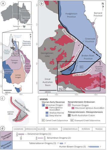
Figure 1. (a) Map showing the subdivision of the Tasmanides into five orogens (after Rosenbaum, Citation2018). (b) Geological map of the Mossman Orogen and adjoining tectonic blocks (modified from Henderson et al., Citation2013). (c) Schematic representation of the orocline (pink coarse line). (d) Orogenic phases within the Thomson and Mossman orogens (after Rosenbaum Citation2018). Approximate ages (in Ma) are indicated by numbers (not in parentheses). Numbers in parentheses correspond to the respective references: (1) Withnall et al. (Citation1996) and Nishiya et al. (Citation2003); (2) Fergusson et al. (Citation2005) and Ali (Citation2010); (3) Henderson et al. (Citation2011).
The architecture and tectonic significance of the Clarke River Shear Zone have been addressed in previous studies (Arnold & Fawkner, Citation1980; Bell, Citation1980; Edgar et al., Citation2022; Harrington, Citation1981; Henderson, Citation1987; Klootwijk, Citation2013; Withnall & Lang, Citation1993), but many problems remained unresolved. Outstanding questions include: (i) What are the architecture and kinematics of the Clarke River Shear Zone? (ii) What were the conditions during deformation? (iii) When did the main phase of reactivation take place? (iv) How did the shear zone contribute to the evolution of the eastern Gondwanan active margin system? To address these questions, we conducted a detailed structural investigation along the western segment of the Clarke River Shear Zone. Our new observations, combined with interpretation of aeromagnetic images and U–Pb geochronology, allow us to better understand the development of structural fabrics within the shear zone and the tectonic significance of this major structure.
Geological setting
The eastern portion of the Australian continent, commonly referred to as the Tasmanides (), is a collage of orogens that were developed along the eastern margin of Gondwana from Cambrian to Triassic (Cawood, Citation2005; Coney et al., Citation1990; Glen, Citation2013; Rosenbaum, Citation2018). The five orogens within the Tasmanides—Delamerian, Thomson, Lachlan, Mossman and New England orogens—generally become younger from west to east (). The Tasmanides represent an exceptional example of a long-lived active margin that has not experienced a final stage of continent–continent collision (Glen, Citation2013).
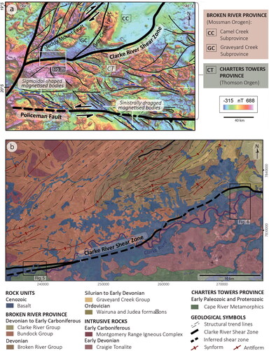
Two components of the Tasmanides, the Thomson and Mossman orogens, are outcropping in northeastern Queensland (). The Thomson Orogen occupies a large portion of northeastern Australia (), but owing to an extensive sedimentary cover, outcrops are limited to few inliers, which include, in northeastern Queensland, the Anakie, Charters Towers, Greenvale, and Barnard provinces (). These inliers comprise Neoproterozoic to Ordovician metasedimentary and igneous rocks, which are considered to represent remnants of the eastern Gondwanan passive margin following the breakup of Rodinia, and an early stage (Cambrian–Ordovician) of active margin orogenesis (Fergusson & Henderson, Citation2013; Fergusson et al., Citation2007; Murray & Kirkegaard, Citation1978; Withnall & Henderson, Citation2012). Rocks of the Thomson Orogen experienced deformation and metamorphism during the late Cambrian Delamerian orogeny and the Late Ordovician to early Silurian Benambran orogeny (; Ali, Citation2010; Fergusson & Henderson, Citation2013; Fergusson et al., Citation2007; Fergusson et al., Citation2005; Henderson et al., Citation2011; Nishiya et al., Citation2003; Rosenbaum, Citation2018; Withnall et al., Citation1996). In the area investigated in our study, the Thomson Orogen is represented by the Charters Towers Province ( and ). This province contains Neoproterozoic to lower Paleozoic rocks belonging to the Cape River Metamorphics and Running River Metamorphics (Fergusson & Henderson, Citation2013). The boundaries of the Charters Towers Province are delineated by the Clarke River Shear Zone to the north and the Policeman Fault Zone to the south (). Based on the analysis of aeromagnetic data, and the recognition of sigmoidal-shaped magnetised bodies, it has been suggested that the Policeman Fault Zone is a sinistral strike-slip fault (; Abdullah & Rosenbaum, Citation2018). The interpretation of geophysical data has further demonstrated that sinistral kinematic indicators dominate the area bounded between the Policeman Fault Zone and the Clarke River Shear Zone (; Abdullah & Rosenbaum, Citation2018).
Figure 2. (a) Composite image of RTP aeromagnetic data over tilt derivative (60% transparent) with structural interpretation (modified from Abdullah & Rosenbaum Citation2018). (b) Simplified geological map of the western segment of the Clarke River Shear Zone and adjoining units (modified from Withnall & Lang, Citation1992). For the map location, see .
The Mossman Orogen consists predominantly of deformed Silurian–Devonian marine sedimentary and igneous rocks, which did not experience Benambran contractional deformation (; Henderson et al., Citation2013; Withnall & Henderson, Citation2012). The orogen abuts the basement blocks of the Thomson Orogen and the North Australian Craton through a network of crustal-scale faults and shear zones, including the Teddy Mount Fault, Burdekin River Fault, and Palmerville Fault to the west, and the Clarke River Shear Zone to the south (; Henderson et al., Citation2013; Withnall & Henderson, Citation2012; Withnall & Lang, Citation1993). The map-view curved geometry of the Mossman Orogen () has been regarded as an orocline by Bell (Citation1980) and Musgrave (Citation2015). The orogen comprises two tectonic sectors known as the Hodgkinson Province (to the north) and the Broken River Province (to the south) (; Arnold & Fawkner, Citation1980; Arnold & Henderson, Citation1976; Henderson et al., Citation2013; Withnall et al., Citation1987). Another component of the Mossman Orogen is the Pama Igneous Association, which is a belt of Silurian–Devonian granitoids intruded into the older adjoining tectonic units of the Thomson Orogen and North Australian Craton (; Bultitude et al., Citation2013). The tectonic setting associated with the emplacement of these granitoids has been interpreted as an arc (Henderson, Citation1987; Henderson et al., Citation2011) or an extensional backarc (Bultitude et al., Citation1997). The timing of deformation along the Mossman Orogen is not well constrained, but it is generally considered to have occurred during the Late Devonian and early Carboniferous (so called Tabberabberan Orogeny; ; Day et al., Citation1978; Henderson, Citation1980; Henderson et al., Citation2013). Parts of the Hodgkinson Province were also affected by a younger (Permian–Triassic) phase of deformation, commonly known as the Hunter–Bowen Orogeny (; Davis et al., Citation2002).
The Clarke River Shear Zone experienced multiple phases of reactivation, from the early Paleozoic to the Carboniferous (Arnold & Fawkner, Citation1980; Edgar et al., Citation2022; Henderson, Citation1987; Korsch et al., Citation2012; Rosenbaum et al., Citation2024; Withnall & Lang, Citation1993). The surface expression of the Clarke River Shear Zone is commonly masked by upper Paleozoic and Cenozoic cover rocks, but traces of the shear zone are intermittently found along the boundary between the Mossman Orogen (Broken River Province) and the Thomson Orogen (Charters Towers Province) (). Exposures of the shear zone reveal a wide, steeply dipping, east-northeast-striking, high-strain ductile zone, superimposed by brittle damage zones with similar orientations (Henderson et al., Citation2013; Henderson & Withnall, Citation2013; McLennan, Citation1986; Withnall & Lang, Citation1993).
In the eastern sector of the Clarke River Shear Zone, deformed rocks include Ordovician metamorphic rocks (Running River Metamorphics), whose structural fabrics are parallel the shear zone. Amphibolite with oceanic island basalt-like affinity and minor ultramafic rocks within the metamorphic complex were interpreted as relicts of accreted oceanic arc basalts and obducted ophiolitic components, respectively (Dirks et al., Citation2021). An ultrahigh-pressure mineral assemblage has been recognised in the metamorphic suite, indicating a possible history of subduction and collision, with the Clarke River Shear Zone being an early Paleozoic continental suture (Edgar et al., Citation2022).
The western sector of the Clarke River Shear Zone, which is the primary focus of this paper, includes lower Paleozoic rocks of Charters Towers Province (Cape River Metamorphics), Devonian igneous rocks (Craigie Tonalite) and Silurian to lower Carboniferous sedimentary successions (Graveyard Creek Subprovince) ( and ). The Cape River Metamorphics consist mainly of amphibolite, schist and gneiss, with minor migmatite lenses. These rocks were subjected to multiple phases of deformation and metamorphism under amphibolite-facies conditions (Fergusson & Henderson, Citation2013; Fergusson et al., Citation2005; Hutton, Bultitude, & Withnall, Citation1997). Their protolith age is Neoproterozoic to Cambrian (Fergusson & Henderson, Citation2013), and the timing of deformation and metamorphism is estimated at ca 500 Ma (Hutton, Draper et al., Citation1997; Withnall et al., Citation1997). The Devonian Craigie Tonalite is intruded into the Cape River Metamorphics and consists predominantly of hornblende–biotite tonalite (; Bultitude et al., Citation2013). The intrusion is considered an I-type granitoid, but the tectonic environment associated with its emplacement is a matter of debate (Bultitude et al., Citation2013; Richards, Citation1980). Hornblende K–Ar isotopic dating of the Craigie Tonalite yielded an age of 406 ± 3 Ma (Rienks & Withnall, Citation1996).
The Graveyard Creek Subprovince includes Silurian to lower Carboniferous shallow-marine siliciclastic successions that were likely deposited in a forearc basin (Arnold & Henderson, Citation1976; Henderson, Citation1987; Henderson et al., Citation2011; Henderson & Withnall, Citation2013; Withnall et al., Citation1987). The age of the basin is well constrained based on its fossil record (Henderson & Withnall, Citation2013; Withnall et al., Citation1987). This sedimentary package is intruded by late Carboniferous granitoids of the Montgomery Range Igneous Complex (Henderson & Withnall, Citation2013; Rosenbaum et al., Citation2024; Withnall, Citation1997; Withnall & Lang, Citation1993). The entire area, including the granitic intrusions, is deformed by northeast-trending folds (Henderson & Withnall, Citation2013; Rosenbaum et al., Citation2024; Withnall et al., Citation1987; Withnall & Lang, Citation1992, Citation1993).
Methods
Fieldwork was conducted in the western segment of Clarke River Shear Zone () and involved the description of 300 outcrops and production of structural maps. Sixty thin-sections were prepared for microstructural analysis, with samples cut parallel to the stretching lineation and perpendicular to the mylonitic foliation. Samples with no stretching lineations were cut perpendicular to the mylonitic foliation in two orthogonal directions.
Airborne magnetic data were obtained from GeoResGlobe (http://georesglobe.information.qld.gov.au). Data and image processing were conducted using Geosoft’s Oasis Montaj™ software. The reduced-to-pole (RTP) algorithm was applied to the total magnetic intensity dataset. The algorithm mitigates the influence of both inclination and declination of the Earth’s main magnetic field, thus positioning anomalies directly above their potential sources. To enhance structural features, the First Vertical Derivative and tilt derivative of the RTP image were employed, following the methodology proposed by Ackerman and Dix (Citation1955) and Miller and Singh (Citation1994), respectively. The analysis and interpretation of the airborne magnetic data, conducted following the guidelines by Gunn et al. (Citation1997), enabled us to identify linear magnetic anomalies and kinematic indicators.
Zircon U–Pb dating was employed to determine the crystallisation age of the Craigie Tonalite. Mineral separation involved mechanical crushing using a jaw crusher that was later pulverised with a disc mill to reduce rock chips into mineral size. Floats were removed, and the remaining heavy fraction was dried in a low-temperature oven. Magnetic minerals were separated using a Franz Isodynamic Magnetic Separator, and non-magnetic components were concentrated using a di-iodomethane heavy liquid. Approximately 100 zircon grains were handpicked using a binocular microscope. Selected grains were mounted in 25 mm-diameter discs using non-reactive epoxy resin that was later polished and carbon coated. Cathodoluminescence (CL) imaging was performed using a scanning electron microscope (TESCAN TIMA) to characterise grains morphology, and internal structure.
Zircon U–Pb isotope measurements were carried out using the Agilent 8800 Laser Ablation Inductively Coupled Plasma Mass Spectrometer (LA-ICP-MS) at the Central Analytical Research Facility of Queensland University of Technology (CARF-QUT). Grains were ablated using a 30 μm spot size beam, with fluence of 2 J/cm3. U–Pb measurements were conducted using TEMORA-2 (Black et al., Citation2003) as the primary calibration standard; the secondary standards, Plešovice (Sláma et al., Citation2008) and 91500 (Wiedenbeck et al., Citation1995), were used to monitor precision and accuracy of the analytical session for U–Th–Pb ages. Some trace elements (Ti, Y, Zr, La, Eu, Yb, Hf, Pb, Th and U) were also measured during the experiment, with NIST610 glass being used as a primary standard for data reduction. Si was used as the internal standard element and a concentration of 15.22 wt% was applied to all zircons.
Raw data were reduced using Iolite software (Paton et al., Citation2011). Data displaying abnormally high concentrations of P (>1500 ppm), Ti (>150 ppm), and La (>2 ppm) were not plotted owing to the potential contamination from inclusions. Discordant data (predominantly the result of high common Pb) were excluded from the analysis and corrections for common Pb using a 208Pb based correction were considered. U–Pb zircon ages were plotted using Isoplot-R software (Vermeesch, Citation2018) with 2σ standard error uncertainty displayed (Ludwig, Citation2003). Data are presented in the Supplemental data (Appendix 1).
Structural observations
Aeromagnetic interpretation
The interpretation of the gridded aeromagnetic images shows that the Clarke River Shear Zone coincides with a boundary that separates two domains with distinctive magnetic signatures (). A relatively low magnetic response in the area north of the shear zone corresponds to non- to weakly magnetic sedimentary rocks of the Mossman Orogen. South of the shear zone, igneous and metamorphic rocks (Cape River Metamorphics, Craigie Tonalite, and Cenozoic basalt flows) are associated with a relatively high magnetic response, marked by the presence of highly magnetised anomalies of irregular shapes with diffuse boundaries, as well as highly magnetised linear anomalies.
Figure 3. (a) Composite image of the reduced-to-pole (RTP- colour, 60% transparent) draped on RTP First Vertical Derivative image (grey scale). (b) Structural interpretation of magnetic lineaments from gridded aeromagnetic images, suggesting a predominant dextral sense of shear along the Clarke River Shear Zone (CRSZ), and subordinate sinistral kinematics farther south (thin black lines are representing the structural form lines). (c) Simplified geological map showing dextral sigmoidal geometry of Silurian rocks close to CRSZ (Gunther et al., Citation1997). (d, e) Simplified geological maps (adapted from Withnall & Lang, Citation1992) and structural interpretation of magnetic lineaments showing dextral kinematics associated with Early Devonian intrusions (d), and sinistral kinematics associated with the Cape River Metamorphics (e).
Within the southern domain, immediately south of the Clarke River Shear Zone, a series of relatively high-frequency (short wavelength), moderately magnetised, narrow linear anomalies exhibit an overall northeast–southwest orientation, with some inflecting towards the east-northeast–west-southwest when approaching the shear zone (). These highly magnetised anomalies, which merge obliquely with the Clarke River Shear Zone, terminate at the shear zone and occur predominantly within the Craigie Tonalite (). Considering the correlation with field data, we interpret these linear anomalies as expressions of the ductile foliation recognised within the intrusion, which is characterised by similar northeast–southwest and east-northeast–west-southwest orientations (). The geometry of these lineaments, and their orientation relative to the Clarke River Shear Zone, may correspond to a dextral drag along the shear zone. A similar sense of shear is also inferred from map relationships along the northeastern segment of the Clarke River Shear Zone, where a sigmoidal geometry indicative of dextral kinematics is recognised in the map-view pattern of Silurian rock units in the proximity of the shear zone ().
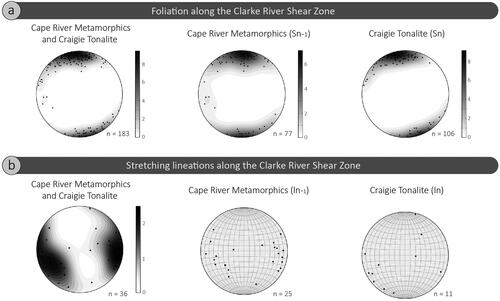
Figure 4. Equal area, lower hemisphere stereographic projections of structural fabrics observed in the Cape River Metamorphics and Craigie Tonalite along the Clarke River Shear Zone. (a) Foliation. (b) Stretching lineation.
South of the Clarke River Shear Zone, in the area dominated by the Cape River Metamorphics, linear to curvilinear relatively high magnetic anomalies are oriented northwest–southeast to north-northwest–south-southeast (). These magnetic lineaments are terminated against east-northeast–west-southwest-oriented linear anomalies, which are gradually merging with the east–west-trending Clarke River Shear Zone. Collectively, the northwest–southeast to north-northwest–south-southeast-trending highly magnetised lineaments compose a sigmoidal pattern consistent a sinistral movement ().
Ductile shear fabrics
Field data from the western sector of the Clarke River Shear Zone show evidence of a wide (up to 3 km) steeply dipping high-strain ductile zone. Mylonitic fabrics are recorded both in the Cape River Metamorphics and Craigie Tonalite. In both units, the foliation is steeply dipping and parallel to the Clarke River Shear Zone, striking approximately east–west along the western segment and northeast–southwest along the eastern segment (, and ). The transition between rock types (Cape River Metamorphics and the Craigie Tonalite) is gradual, with the contact zone characterised by the occurrence of xenoliths and mafic enclaves within the tonalite, and tonalitic dykes and sills within the Cape River Metamorphics. Tonalitic dykes and sills are generally concordant with the foliation.
Figure 5. (a) Geological map of the western segment of the Clarke River Shear Zone (modified from Withnall & Lang Citation1992; for the location, see ). (b) Equal area, lower hemisphere stereographic projections of foliation in the Cape River Metamorphics and Craigie Tonalite, showing an overall east–west orientation. (c) Cataclasite in a brittle damage zone.
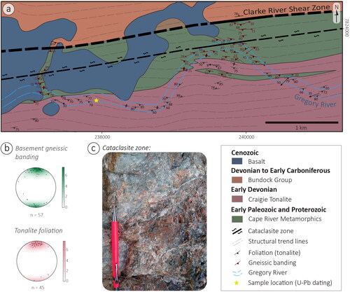
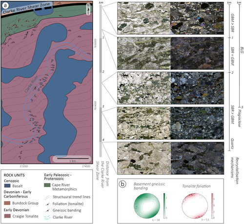
Figure 6. (a) Geological map (modified Withnall & Lang Citation1992; for the location, see ), and photomicrographs (plane and cross-polarised) showing heterogeneous deformation pattern along the tonalite in a cross-section perpendicular to the shear zone. Note that textures and inferred recrystallisation mechanisms on quartz and plagioclase are variable along this section and that foliation is still recognised >3 km from the shear zone. (b) Equal area, lower hemisphere stereographic projections of foliation in the Cape River Metamorphics and Craigie Tonalite, showing an overall northeast–southwest orientation. Recrystallisation mechanisms: BLG, bulging; SGR, subgrain rotation; GBM, grain boundary migration.
The Cape River Metamorphics along the Clarke River Shear Zone comprise deformed felsic gneiss, amphibolite and migmatite, as well as minor quartzite and chlorite schist (). Migmatite leucosome occurs along foliation planes, which are defined by gneissic banding and schistosity (). Stretching lineations are weak and gently plunging (). Evidence of deformation includes mesoscale vertical disharmonic asymmetrical folds (), shear-related sigmoids, deformed and disrupted gneissic bands, and migmatitic leucosome phase or pegmatitic veins (). Folds and centimetric-scale sigmoids exhibit a sinistral sense of shear ().
Figure 7. Kinematic indicators in rocks from the Cape River Metamorphics showing a dominant sinistral sense of shear. (a, b) Field photos of asymmetric folds. (c, d) Field photos showing sigmoids in sheared migmatite. (e) Photomicrographs (plane and cross-polarised) and interpretation of mylonite with microfolds, δ- and σ-type porphyroclasts. The complex microstructural patterns may have resulted from superposition of early sinistral shearing and a later stage of general dextral shear. Abbreviations: Qtz, quartz; Ep, epidote; Chl, chlorite; Bt, biotite.
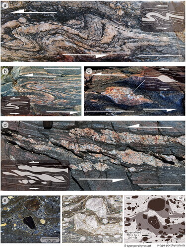
Table 1. Description of main rock types within the Cape River Metamorphics in the western sector of Clarke River Shear Zone.
Protomylonites and mylonites within the Cape River Metamorphics occur predominantly in migmatite and chlorite schist. Observed mylonitic microstructures include δ- and σ-type porphyroclasts (hornblende, plagioclase, and K-feldspar) surrounded by fine-grained recrystallised quartz-rich matrix (). Quartz ribbons and mica fish are also recognised. S-C fabrics are poorly developed, but more complex structural patterns (e.g. microfolds) are common (). Microstructural observations show evidence of quartz recrystallisation through subgrain rotation and/or grain boundary migration mechanisms. Polygonal polycrystalline quartz aggregates and ribbons are commonly oriented along the foliation (). Feldspar porphyroclasts are generally subheudral or show augen geometry () with partial dynamic recrystallisation by bulging along grain boundaries.
The Craigie Tonalite, along the Clarke River Shear Zone, is foliated medium- to coarse-grained hornblende tonalite ( and ). Biotite is locally a main component, and accessory minerals include epidote, chlorite, allanite, apatite and zircon. Epidote, which comprises up to 6% of the rock, occurs as well-formed euhedral to anhedral crystals ranging in size from 10 to 100 μm. In some cases, allanite forms cores within epidote crystals, indicating a potential magmatic origin for at least part of the crystals (da Cunha et al., Citation2021; Schmidt & Poli, Citation2004; Zen & Hammarstrom, Citation1984). Epidote also occurs in veins or as small aggregates in apparent disequilibrium with hornblende and plagioclase ().
Figure 8. Structures in the Craigie Tonalite in outcrops and thin-sections (plane and cross-polarised photomicrographs). (a) Flattened microcrystalline-dioritic enclaves oriented parallel to the intrusion foliation. (b) Foliation defined by compositional layering and grainsize variation. Leucocratic levels are interlayered with hornblende-rich levels. (c) Anastomosing foliation with cleavage domains wrapping around plagioclase (Pl) and hornblende (Hbl) porphyroclasts. The asymmetry suggests dominant dextral and subordinate sinistral sense of shear. (d) Bar chart illustrating the relative proportion of shear senses determined based on field and microstructural kinematic indicators. The high proportion of symmetric kinematic indicators, together with evidence of sinistral, dextral and reverse kinematic indicators, suggests general shear deformation with a dextral component.
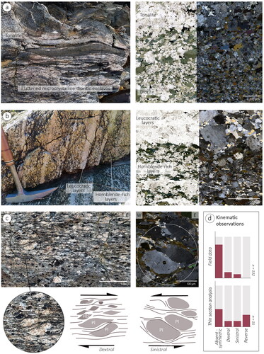
Figure 9. Cross-polarised light photomicrographs from the Craigie Tonalite, depicting the main textures identified in quartz (Qtz) and plagioclase (Pl). (a, b) Lobate contacts and recrystallised grains along plagioclase boundaries suggest incipient recrystallisation by bulging (BLG). The strain-free character of polycrystalline quartz with irregular grain boundaries suggests recrystallisation by grain boundary migration (GBM). (c) Subgrains and recrystallised grains at the edge of a quartz relict suggest subgrain rotation (SGR) as a recrystallisation mechanism. Note the transitional character between newly formed grains and subgrains, typical of SGR. (d) Plagioclase deformation twinning (flame-shape twinning).
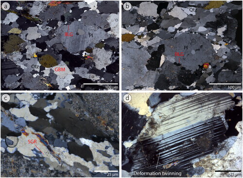
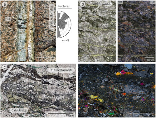
Figure 10. (a) Field photo of a centimetre-thick vein filled with chlorite (Chl), epidote (Ep), and quartz (Qz), and a rose diagram showing strike orientations of fractures and veins. (b) Photomicrographs (plane and cross-polarised) of chloritic–epidote alteration in the Craigie Tonalite. (c) Photomicrographs (plane and cross-polarised) of cataclasite and ultracataclasite zones, which occur parallel to the ductile structural fabrics in the Craigie Tonalite.
The foliation in the Craigie Tonalite is generally parallel to the foliation in the Cape River Metamorphics (). Some of the foliation appears igneous in origin, as indicated by the preferred orientation of elongated and perfectly euhedral plagioclase crystals (a criterion used to identify magmatic flow patterns; e.g. Paterson et al., Citation1989). In addition, there is evidence of tectonic foliation, associated with the alignment of amphibole, mica and quartz aggregates, giving rise to compositional layering and anastomosing foliation (). Compositional layering is characterised by alternating leucocratic bands, dominated by quartz and plagioclase, and hornblende-rich layers that commonly consist of aligned epidote and chlorite (). Grainsize variations along these bands are also recognised. The anastomosing foliation is defined by preferred orientation of chlorite and biotite (). The latter minerals commonly wrap around plagioclase and hornblende porphyroclasts, forming augen geometries. Flattened mafic enclaves and xenoliths are common (), especially close to the contact zone between the Craigie Tonalite and the Cape River Metamorphics.
The tectonic foliation in the Craigie Tonalite has a consistent orientation (), but its distribution is heterogeneous (). Localised high-strain zones are separated by less deformed zones that only show evidence of igneous foliation and/or incipient tectonic foliation (). Protomylonites and mylonites are recognised in localised high-strain zones. However, the scarcity of stretching lineation () and abundance of symmetric porphyroclasts makes shear-sense determination challenging (). When recognised, S-C fabrics can show predominantly dextral shear sense, particularly in field observations (). However, evidence of sinistral shear sense is also found, both in field observations and thin-sections (). A reverse kinematic component is also revealed when analysing microstructural observations in thin-sections oriented parallel to the dip direction (). Overall, the high-strain zones are characterised by flattening strain (S-tectonites).
Microstructural observations from the Craigie Tonalite show quartz grains (20–60 μm) in polycrystalline aggregates that surround plagioclase and hornblende porphyroclasts. Strain-free quartz with lobate or irregular grain boundaries indicates grain boundary migration recrystallisation (). In addition, we find evidence of subgrain rotation recrystallisation, based on the transitional character between polycrystalline polygonal quartz aggregates and subgrain domains (). In a transect across the shear zone, grain boundary migration recrystallisation is dominant closer to the shear zone (within a range of up to 1 km), whereas subgrain rotation recrystallisation is dominant away from the shear zone (). Plagioclase porphyroclasts exhibit augen-shape geometries or subhedral crystals (). Observed microstructures include undulose extinction, deformation twinning (flame-shape twining) and, less commonly, kinking and fracturing (). Incipient recrystallisation by bulging is recognised along the porphyroclast boundaries, which tend to be irregular or loboid (). Plagioclase dynamic recrystallisation is less common farther from the shear zone and is absent at a distance of ∼3 km from the shear zone (). Hornblende occurs as subhedral porphyroclasts or as flattened aggregates along cleavage domains. It is commonly altered to chlorite and epidote. Chlorite–epidote alteration is more intense closer to the Clarke River Shear Zone. Both chlorite and epidote occur in veins () or as pervasive secondary alteration of hornblende.
Brittle faulting
A cataclasite zone within the Clarke River Shear Zone provides evidence of brittle faulting (). The cataclasite zone is 3–5 m wide and is parallel to the ductile shear zone, affecting rocks immediately south (0–500 m) of the boundary between the Broken River and Charters Tower provinces (). The microscopic to mesoscopic cataclasite and ultracataclasite zones commonly obliterate older fabrics ( and ). Microscopic cataclasite zones are consistently parallel to the ductile foliation ().
The brittle zone is characterised by pervasive chloritic–epidote alteration, as well as abundant micro- to mesoscale veins filled with quartz, epidote, and chlorite (). Veins occur in a range of orientations, with the most dominant orientation being N30°E to N60°E ().
Geochronology
One sample from the Craigie Tonalite, along the western sector of Clarke River Shear Zone, was selected for U–Pb dating (see location in ). The sample is a weakly foliated, medium-grained hornblende tonalite comprising plagioclase (55%), quartz (25%), hornblende (10%) and K-feldspar (<5%). Accessory phases (5%) are chlorite, epidote, allanite, apatite and opaque minerals. The rock is inequigranular and includes plagioclase and hornblende porphyroclasts with subhedral to augen shape. These crystals generally range in size from 2 to 5 mm and are typically surrounded by polygonal aggregates of recrystallised quartz, ranging from 10 to 40 μm.
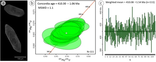
Dated zircon grains are euhedral to subhedral and generally exhibit elongated habit with 1:2 to 1:4 aspect ratio (). Most crystals are 50–300 μm long and show clear oscillatory patterns in cathodoluminescence images (), indicating an igneous origin (Rubatto, Citation2002). Analysis of 111 spots yields a U–Pb concordia age (206Pb/238U vs 207Pb/235U) of 410.3 ± 1.1 Ma, with an MSWD of 1.1 (). Zircon weighted mean plots show individual grain ages and a weighted mean of 410.08 ± 1.54 Ma (). The data show a single population of zircon grains with no significant inheritance.
Figure 11. (a) Cathodoluminescence images of selected zircons showing euhedral to subhedral crystals with clear oscillatory patterns. (b) Zircon 206Pb/238U vs 207Pb/206Pb calculated concordia Tera–Wasserburg diagram showing a concordia age of 410.30 ± 1.06 Ma with no clear evidence for inheritance. (c) Weighted mean ages. N = number of zircon grains analysed per sample.
Discussion
Structure and kinematics of the Clarke River Shear Zone
Our field observations show that the Clarke River Shear Zone is a subvertical structure that changes its orientation from roughly east–west in the western sector to northeast–southwest farther east (). The interpretation of deep seismic reflection data suggests that the shear zone is a crustal-scale structure that maintains its steeply dipping orientation at depth (Korsch et al., Citation2012; Withnall et al., Citation2009). The structure encompasses a broad (up to 3 km wide) high-strain zone associated with steeply dipping foliation (, and ). We consider that the development of this foliation was directly linked to the deformation along the Clarke River Shear Zone. Indeed, farther from the Clarke River Shear Zone, the dominant fabrics deviate from the above-mentioned orientations. For example, in the Cape River Metamorphics, approximately 40 km from the Clarke River Shear Zone, the dominant foliation is subhorizontal (Fergusson et al., Citation2005). In the eastern sector of the Clarke River Shear Zone, pre-existing fabrics within the Running River Metamorphics change their orientation in the proximity of the shear zone (Dirks et al., Citation2021), thus confirming that deformation along the shear zone was responsible for rotating pre-existing structures.
Based on our field observations, we infer that the Clarke River Shear Zone was subjected to an early phase of sinistral kinematics. This deformation is expressed mainly in the older (lower Paleozoic) rocks of the Cape River Metamorphics, which show vertical asymmetric folds, sheared leucosome and gently plunging stretching lineations ( and ). A similar sense of shear is also inferred from aeromagnetic data, which reveal sigmoidal geometry defined by the orientation and distribution of highly magnetised linear magnetic anomalies to the south of the Clarke River Shear Zone (). A sinistral sense of kinematics has also been inferred by Abdullah and Rosenbaum (Citation2018) based on the interpretation of regional aeromagnetic data.
While evidence of sinistral strike-slip deformation is predominantly displayed by mesoscale ductile structures (e.g. folds and sheared leucosomes) in the Cape River Metamorphics, younger rocks of the Craigie Tonalite show evidence of mylonitic fabric (and no folding). This fabric may have formed by a later stage of deformation unrelated to sinistral strike-slip shearing. Kinematic indicators in the mylonite are predominantly dextral, but sinistral shear sense criteria are also observed, as well as symmetric porphyroclasts and flattened enclaves (). Moreover, while the protomylonites and mylonites in the Craigie Tonalite exhibit strong foliation, the stretching lineation is poorly developed (). Therefore, the rocks are interpreted as S-tectonites that represent flattening strain. This style of strain could have been produced by deformation dominated by general shear with a dextral-reverse component. Dextrally curved lineaments, recognised in aeromagnetic images () and sigmoidal dextral features in geological maps (), may have formed during this phase of deformation. This interpretation is consistent with previous work by McLennan (Citation1986), who identified mylonitic structures indicative of dextral sense of shear along the Clarke River Shear Zone.
It is possible that the superposition of the early phase of sinistral shearing and the later stage of general dextral shear produced the complex microstructural patterns recognised in samples from the Cape River Metamorphics (). Some of the microstructures resemble interference patterns recognised in shear zones that experienced multiple phases of deformation with opposite senses of shear (Finch et al., Citation2022). In contrast, samples from the Craigie Tonalite do not show evidence of fabric superimposition. Therefore, based on the observations that fabric superimposition is recognised exclusively in the Cape River Metamorphics, we suggest that this older rock unit records an earlier phase of sinistral deformation that took place prior to the emplacement of the Craigie Tonalite. According to this interpretation, the few sinistral kinematic indicators identified in the Craigie Tonalite are unlikely relics of an earlier deformation and more likely represent a response to flattening strain.
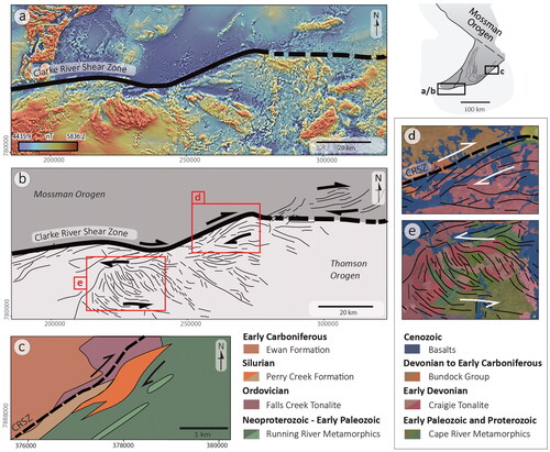
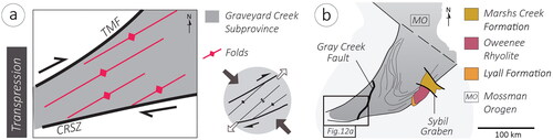
Prevailing dextral general shear continued during brittle reactivation along Clarke River Shear Zone and was likely responsible for deforming the sedimentary successions north of the shear zone (in the Graveyard Creek Subprovince) (Withnall & Lang, Citation1993). The regional deformation in this area, dominated by northeast–southwest folds (), is kinematically compatible with dextral transpression in a corridor bounded by the Clarke River Shear Zone and Teddy Mount Fault (; Rosenbaum et al., Citation2024). Folds in this transpressional corridor are oblique to the shear zones, as expected in response to shearing. However, considering the relatively low angle of obliqueness (∼15°), Rosenbaum et al. (Citation2024) have suggested that the deformation was not associated with simple shear but instead involved general shear associated with northwest–southeast shortening direction ().
Figure 12. (a) Schematic illustration of transpressional deformation in the Graveyard Creek Subprovince during the Carboniferous. (b) Schematic map of the southwestern portion of the Mossman Orogen, highlighting the geological units (Marshs Creek Formation, Oweenee Rhyolite, and Lyall Formation) unaffected by the Clarke River Shear Zone (CRSZ), indicating that activity along the structure ceased prior to the deposition of these units. TMF, Teddy Mount Fault.
Conditions during deformation
The Craigie Tonalite underwent deformation during, or immediately after, its emplacement, as evidenced by the alignment of tectonic igneous foliation parallel to the mylonitic foliation, and its lenticular geometry, which generally follows the structural grain of the Clarke River Shear Zone. These are characteristic features in syn-tectonic intrusions (Bessiere et al., Citation2018; Passchier & Trouw, Citation2005; Vernon et al., Citation1989). We infer that this emplacement occurred at mid-deep crustal levels, based on the absence of contact metamorphism in the host rock (Cape River Metamorphics), and the presence of gradational contacts between the intrusion and the surrounding rocks (e.g. Winter, Citation2010). The closeness in age of the U–Pb zircon (410.3 ± 1.1 Ma) and K–Ar hornblende (406 ± 3 Ma) ages (Rienks & Withnall, Citation1996) suggests that the argon age records magmatic cooling from peak temperature over a few millions of years. The presence of magmatic epidote further suggests that the tonalite magmatic system paused and mostly crystallised at middle to lower crustal conditions (Sial et al., Citation1999; Zen & Hammarstrom, Citation1984)
Our microstructural observations support the suggestion that ductile deformation occurred in middle to lower crustal levels. In such crustal levels, middle- to high-temperature mylonites, in amphibolite-facies conditions, involve dynamic recrystallisation by grain boundary migration and subgrain rotation (for quartz) and partial recrystallisation by bulging (for plagioclase) (Passchier & Trouw, Citation2005; Trouw et al., Citation2010). These deformation mechanisms are inferred from our microstructural observations ().
Variations in recrystallisation mechanisms observed in a transect across the shear zone () suggest that shear heating may have played a role during deformation. Closer to the shear zone, higher-temperature recrystallisation mechanisms in quartz and feldspar (e.g. grain boundary migration in quartz and bulging in plagioclase) prevail (). Conversely, farther from the core of the shear zone, lower-temperature recrystallisation processes dominate (e.g. quartz subgrain rotation and lesser bulging in plagioclase; ).
The presence of a cataclasite zone () provides evidence of brittle deformation mechanisms, indicating that the Clarke River Shear Zone was reactivated at shallower crustal levels. Brittle deformation was accompanied by intense hydrothermal activity, leading to the chloritic–epidote alteration across the fault zone (). This phase of brittle faulting might have been accompanied by folding in the Graveyard Creek Subprovince, likely in a relatively shallow crustal level, as indicated by the lack of regional metamorphism and ductile structural fabrics.
Timing of deformation
Evidence of sinistral shearing along the Clarke River Shear Zone is preserved mainly in older rocks (Cape River Metamorphics) but is uncommon in the Craigie Tonalite. It is therefore likely that sinistral strike-slip deformation occurred prior to the emplacement of the Craigie Tonalite (i.e. prior to ca 410 Ma). This phase of deformation could have occurred simultaneously with the deformation described by Dirks et al. (Citation2021) in the eastern sector of the Clarke River Shear Zone. In this area, pre-existing fabrics within the Running River Metamorphics were rotated in response to sinistral shearing (Dirks et al., Citation2021). Based on the ages of an orthogneiss (ca 472 Ma) and an undeformed migmatite (ca 437 Ma), Dirks et al. (Citation2021) have suggested that this deformation, in the in the eastern sector of the Clarke River Shear Zone, took place during the late Ordovician and/or early Silurian.
Ductile general shearing along the Clarke River Shear Zone likely occurred during the Early Devonian, during or immediately after the emplacement of the Craigie Tonalite. This age constraint is supported by the syn-tectonic nature of this intrusion and the structural fabrics within the tonalite that suggest general dextral shear deformation. The zircon U–Pb age of 410.3 ± 1.1 Ma () constrains the timing of crystallisation, as well as the approximate age of the deformation along the Clarke River Shear Zone.
Transpressional deformation likely continued following the sedimentation of Devonian–Carboniferous rocks in the Graveyard Creek Subprovince (). The dominant folds in this area were supposedly generated by dextral transpression (Rosenbaum et al., Citation2024; Withnall & Lang, Citation1993) (). During the Carboniferous, at 335–320 Ma, intrusions belonging to the Montgomery Range Igneous Complex were emplaced syn-kinematically in the Graveyard Creek Subprovince (Rosenbaum et al., Citation2024). It appears, therefore, that the western sector of the Clarke River Shear Zone was still active at ca 320 Ma.
In the eastern sector, the Clarke River Shear Zone is truncated by a small graben (Sybil Graben; ), which hosts Carboniferous and/or lower Permian sedimentary rocks of the Marshs Creek Formation (e.g. Gunther et al., Citation1997, Fergusson & Henderson, Citation2013). Map relationships in the same area further indicate that the Clarke River Shear Zone is crosscut by the Oweenee Rhyolite and related plutonic rocks of the Oweenee Supersuite () (e.g. Gunther et al., Citation1997). These observations suggest that the eastern sector of the Clarke River Shear Zone was inactive after 330 Ma, which is the approximate age of the Oweenee Rhyolite (based on the age of the Kallanda Granite, a constituent of the Oweenee Supersuite; Gunther & Withnall, Citation1995). Furthermore, sedimentary rocks underlying the Oweenee Rhyolite, belonging to the Visean Lyall Formation, also seem unaffected by movement along the shear zone in this area (e.g. Gunther et al., Citation1997) (). Altogether, the evidence suggests that post-Visean deformation along the Clarke River Shear Zone was confined to the western segment, east of its junction with the Gray Creek Fault ().
Implications for the evolution of the Eastern Gondwana margin
Our results do not provide new data on the origin and early history of the Clarke River Shear Zone, but previous studies have suggested that the eastern sector of this shear zone is an early Paleozoic suture (Dirks et al., Citation2021; Edgar et al., Citation2022). Evidence of ultra-high-pressure metamorphism has been reported in rocks from the proximity of the shear zone (Edgar et al., Citation2022), and Early Ordovician (ca 472 Ma) granitoids were inferred to be related to a continental arc (Dirks et al., Citation2021). Other rock units from the eastern sector may represent seamount successions (pelagic sandstone and amphibolite with oceanic island basalt-like affinity) and ophiolitic material, which, according to Dirks et al. (Citation2021), represent an Ordovician accreted island arc terrane. Other Ordovician island arc/oceanic associations along the Gray Creek Fault (; Henderson et al., Citation2011) may represent the northward continuation of this arc–continent suture zone.
We hypothesise that the Clarke River Shear Zone became a sinistral transform fault during the Silurian, accommodating subduction segmentation along the eastern Gondwanan margin (). North of the Clarke River Shear Zone, subduction processes produced continental arc magmatism (e.g. dominantly S-type granitoids dated 434–421 Ma; Bultitude et al., Citation2013), as well as forearc basin and accretionary complex units (Arnold & Henderson, Citation1976; Henderson, Citation1987; Henderson et al., Citation2013; Henderson & Fergusson, Citation2019; Henderson et al., Citation2011; Henderson & Withnall, Citation2013; Withnall et al., Citation1987). In contrast, in the area immediately south of the Clarke River Shear Zone, there is little evidence of Silurian subduction processes, possibly because the subduction zone was positioned east of the area that is presently preserved in northeastern Australia. It is possible that the link between the Silurian subduction zone of the Mossman Orogen and the subduction zone father south (i.e. in the New England and Lachlan orogens; Rosenbaum, Citation2018) was a transform plate boundary along the Clarke River Shear Zone ().
Figure 13. Schematic reconstruction of the northern Tasmanides during the Silurian and Devonian periods. (a) The Clarke River Shear Zone (CRSZ) depicted as a sinistral transform zone during the Silurian. (b) The model is based on the assumption that the Charters Towers Province (including the Clarke River Shear Zone) was a transitional zone between retreating and non-retreating plate boundaries during the Devonian. The spatio-temporal distribution of tectonic elements is based on Rosenbaum (Citation2018).
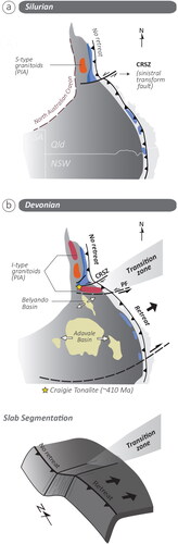
During the Devonian, continental arc magmatism continued north of the Clarke River Shear Zone, but also commenced along the shear zone itself (e.g. Craigie Tonalite) and south of it (; Bultitude et al., Citation2013; Rosenbaum, Citation2018). North of the Clarke River Shear Zone, the presence of Devonian (410–395 Ma) granitoids along the strike of the Silurian (434–421 Ma) ones indicates that the northern subduction segment was not subjected to trench retreat (Rosenbaum, Citation2018). In contrast, south of the shear zone, the trench was likely retreating, as indicated by overriding-plate extension that produced widespread (backarc) sedimentary basins (e.g. the Lower–Middle Devonian Belyando and Adavale basins; ; Abdullah & Rosenbaum, Citation2018; Rosenbaum, Citation2018). The occurrence of these basins mainly south of the Charters Towers Province may suggest that the Clarke River Shear Zone and its vicinity, including the Charters Towers inlier, were situated at a transitional zone between the non-retreating subduction zone and the highly mobile plate boundary farther south (). Considering this scenario, one could speculate that the emplacement of granitoids, such as the Craigie Tonalite, perpendicular to the plate boundary, was associated with the process of trench segmentation (e.g. slab tearing; ).
We note that the scenario described above implies an overall sinistral shearing in the transitional corridor. Our results, in contrast, show evidence of dextral general shear during and after the emplacement of the Craigie Tonalite. It is possible that sinistral shearing was accommodated along the Policeman Fault farther south (), as previously suggested by Abdullah and Rosenbaum (Citation2018). Nevertheless, the reason why this deformation was accompanied by dextral general shear along the Clarke River Shear Zone remains unclear. Possible explanations include strain partitioning caused by complexities along the deformation corridor, associated with the presence of the Charters Towers basement rocks, as well as strain modifications in response to syn-tectonic granite emplacement in this transpressional corridor.
By the end of the Devonian, the Clarke River Shear Zone may have influenced the deposition of the Upper Devonian siliciclastic successions of the Bundock Group in the Graveyard Creek Subprovince (). This is suggested by the immature nature of the sedimentary deposits near the shear zone and the notable increase in thickness towards it, reaching over 4000 m adjacent to the shear zone (Withnall & Lang, Citation1992, Citation1993). While we do not have direct field observations supporting syn-sedimentary extension, the possibility of a brittle extensional/transtensional phase of movement along the shear zone, particularly along its western segment, cannot be ruled out.
The final activity along the Clarke River Shear Zone was likely associated with dextral transpression in the area bounded by the Clarke River Shear Zone and Teddy Mount Fault (see ; Rosenbaum et al., Citation2024). The tectonic trigger for the development of this wide (∼30 km) transpressional zone is not fully understood. Klootwijk (Citation2013) suggested that activity along the Clarke River Shear Zone during the early Carboniferous occurred in response to tectonic extrusion caused by the Alice Springs orogeny, which was an intraplate orogenic event in central Australia. Alternatively, deformation during the Carboniferous could have been driven by plate boundary processes, which are particularly prominent in the New England Orogen (e.g. Glen, Citation2005; Donchak et al., Citation2013), and produced widespread arc magmatism both in the New England Orogen and in northeast Queensland (Rosenbaum, Citation2018). Considering that folds with similar orientations to those observed within the transpressional corridor also occur in other locations in northeast Queensland (e.g. Mount Coolon and Charters Towers areas; Clarke et al., Citation1969; Hutton, Law et al., Citation1997), it is possible that northwest–southeast contraction () played an important role during the early Carboniferous evolution of the northeastern Tasmanides.
Conclusions
Our structural investigation along the Clarke River Shear Zone reveals a complex structural and tectonic history spanning from the Silurian to the Carboniferous. The wide subvertical high-strain shear zone was reactivated at least three times. An early ductile phase of sinistral strike-slip shearing, possibly during the Silurian, was followed by general-shear ductile deformation under amphibolite-facies conditions. The latter phase of deformation occurred contemporaneously with the emplacement of the Craigie Tonalite at 410.30 ± 1.06 Ma. The final phase of activity along Clarke River Shear Zone was associated with brittle dextral transpression.
We propose that the Clarke River Shear Zone was a sinistral transform fault during the Silurian. Accelerated rates of trench retreat during the Devonian led to the development of a broad transitional deformation zone south of the Clarke River Shear Zone (e.g. Policeman Fault Zone) and localised dextral general shear along the structure. Final brittle reactivation, during the Carboniferous, was likely associated with dextral transpression.
Supplemental Material
Download MS Excel (101.9 KB)Acknowledgements
We wish to thank Alana Barrett and Michele Elmes for their valuable support during fieldwork, and Charlotte Allen for assisting with U–Pb zircon dating. The geochronology component of this work was enabled by use of the Central Analytical Research Facility (CARF) at the QUT. We also want to thank the reviewers Ian Withnall and Peter Betts for their constructive comments and suggestions that greatly improved the manuscript.
Disclosure statement
No potential conflict of interest was reported by the author(s).
Data availability statement
All data reported in this manuscript are available either in the paper or in the supplemental data.
Additional information
Funding
References
- Abdullah, R., & Rosenbaum, G. (2018). Devonian crustal stretching in the northern Tasmanides (Australia) and implications for oroclinal bending. Journal of Geophysical Research: Solid Earth, 123(8), 7108–7125. https://doi.org/10.1029/2018jb015724
- Ackerman, H. A., & Dix, C. H. (1955). The first vertical derivative of gravity. Geophysics, 20(1), 148–154. https://doi.org/10.1190/1.1438112
- Ali, A. (2010). The tectono-metamorphic evolution of the Balcooma Metamorphic Group, north-eastern Australia: A multidisciplinary approach. Journal of Metamorphic Geology, 28(4), 397–422. https://doi.org/10.1111/j.1525-1314.2010.00871.x
- Arnold, G. O., & Fawkner, J. F. (1980). The Broken River and Hodgkinson Provinces. In R. A. Henderson & P. J. Stephenson (Eds.), The geology and geophysics of northeastern Australia (pp. 175–189). Geological Society of Australia, Queensland Division.
- Arnold, G. O., & Henderson, R. A. (1976). Lower Paleozoic history of the southwestern Broken River Province, North Queensland. Journal of the Geological Society of Australia, 23(1), 73–93. https://doi.org/10.1080/00167617608728922
- Becken, M., Ritter, O., Park, S. K., Bedrosian, P. A., Weckmann, U., & Weber, M. (2008). A deep crustal fluid channel into the San Andreas fault system near Parkfield, California. Geophysical Journal International, 173(2), 718–732. https://doi.org/10.1111/j.1365-246X.2008.03754.x
- Bell, T. H. (1980). The deformation history of northeastern Queensland – a new framework. In R. A. Henderson & P. J. Stephenson (Eds.), The geology and geophysics of northeastern Australia (pp. 307–313). Geological Society of Australia, Queensland Division.
- Bessiere, E., Rabillard, A., Précigout, J., Arbaret, L., Jolivet, L., Augier, R., Menant, A., & Mansard, N. (2018). Strain localization within a syntectonic intrusion in a back-arc extensional context: The Naxos Monzogranite (Greece). Tectonics, 37(2), 558–587. https://doi.org/10.1002/2017tc004801
- Black, L. P., Kamo, S. L., Allen, C. M., Aleinikoff, J. N., Davis, D. W., Korsch, R. J., & Foudoulis, C. (2003). TEMORA 1: A new zircon standard for Phanerozoic U–Pb geochronology. Chemical Geology, 200(1-2), 155–170. https://doi.org/10.1016/S0009-2541(03)00165-7
- Brown, M., & Solar, G. S. (1998). Shear-zone systems and melts: Feedback relations and self-organization in erogenic belts. Journal of Structural Geology, 20(2-3), 211–227. https://doi.org/10.1016/S0191-8141(97)00068-0
- Bultitude, R. J., Champion, D. C., & Hutton, L. J. (2013). Pama Igneous Association. In P. A. Jell (Ed.), Geology of Queensland (pp. 280–296). Geological Survey of Queensland - Queensland Government.
- Bultitude, R. J., Garrad, P. D., Donchak, P. J. T., Domagala, J., Champion, D. C., Rees, I. D., Mackenzie, D. E., Wellman, P., Knutson, J., Fanning, C. M., Fordham, B. G., Grimes, K. G., Oversby, B. S., Rienks, I. P., Stephenson, P. J., Chappell, B. W., Pain, C. F., Wilford, J. R., Rigby, J. F., & Woodbury, M. J. (1997). Chapter 7 Cairns Region. In J. H. C. Bain & J. J. Draper (Eds.), North Queensland Geology (pp. 225–325). Australian Geological Survey Organisation. Bulletin, 240.
- Cawood, P. A. (2005). Terra Australis Orogen: Rodinia breakup and development of the Pacific and Iapetus margins of Gondwana during the Neoproterozoic and Paleozoic. Earth-Science Reviews, 69(3-4), 249–279. https://doi.org/10.1016/j.earscirev.2004.09.001
- Chen, Z., Cheng, X., Huang, X., Bai, W., & Jin, Z. (2014). Three-dimensional numerical analysis of magma transport through a pre-existing fracture in the crust. Journal of Geodynamics, 76, 46–55. https://doi.org/10.1016/j.jog.2014.03.002
- Clarke, D. E., Wyatt, D. H., Paine, A. G. L., Harding, R. R., Gregory, C. M., Olgers, F., Binnekamp, J. G., Vine, R. R., Mcgovern, J. L., Tatarow, A., Swoboda, R. A., Ritschel, R., & Rowland, W. J. (1969). Charters Towers SF55-02. 1:250000 scale Geology Map. Geological Survey of Queensland, Department of Minerals and Energy.
- Clerc, C., Jolivet, L., & Ringenbach, J. C. (2015). Ductile extensional shear zones in the lower crust of a passive margin. Earth and Planetary Science Letters, 431, 1–7. https://doi.org/10.1016/j.epsl.2015.08.038
- Coney, P. J., Edwards, A., Hine, R., Morrison, F., & Windrim, D. (1990). The regional tectonics of the Tasman Orogenic System, eastern Australia. Journal of Structural Geology, 12(5-6), 519–543. https://doi.org/10.1016/0191-8141(90)90071-6
- da Cunha, I. R. V., Dall’Agnol, R., Scaillet, B., & de Sousa, L. A. M. (2021). Magmatic epidote in Archean granitoids of the Carajas Province, Amazonian craton, and its stability during magma rise and emplacement. Journal of South American Earth Sciences, 112, 103570. https://doi.org/10.1016/j.jsames.2021.103570
- Daly, M. C. (1986). Crustal shear zones and thrust belts – their geometry and continuity in Central-Africa. Philosophical Transactions of the Royal Society – Mathematical Physical and Engineering Sciences, 317(1539), 111–128. https://doi.org/10.1098/rsta.1986.0028
- Davis, B. K., Bell, C. C., Lindsay, M., & Henderson, R. A. (2002). A single late orogenic Permian episode of gold mineralization in the Hodgkinson province, north Queensland, Australia. Economic Geology and Geology, 97(2), 311–323. https://doi.org/10.2113/97.2.311
- Day, R. W., Murray, C. G., & Whitaker, W. G. (1978). Eastern part of Tasman Orogenic Zone. Tectonophysics, 48(3-4), 327–364. https://doi.org/10.1016/0040-1951(78)90123-3
- Di Bucci, D., Burrato, P., Vannoli, P., & Valensise, G. (2010). Tectonic evidence for the ongoing Africa–Eurasia convergence in central Mediterranean foreland areas: A journey among long-lived shear zones, large earthquakes, and elusive fault motions. Journal of Geophysical Research: Solid Earth, 115, B12404. https://doi.org/10.1029/2009JB006480
- Dirks, H. N., Sanislav, I. V., & Abu Sharib, A. S. A. A. (2021). Continuous convergence along the paleo-Pacific margin of Australia during the early Paleozoic: Insights from the Running River Metamorphics, NE Queensland. Lithos, 398-399, 106343. https://doi.org/10.1016/j.lithos.2021.106343
- Donchak, P. J. T., Purdy, D. J., Withnall, I. W., Blake, P. R., & Jell, P. A. (2013). New England Orogen. In P. A. Jell (Ed.), Geology of Queensland (pp. 305–472). Geological Survey of Queensland - Queensland Government.
- Dragone, G. N., Ussami, N., Gimenez, M. E., Klinger, F. G. L., & Chaves, C. A. M. (2017). Western Parana suture/shear zone and the limits of Rio Apa, Rio Tebicuary and Rio de la Plata cratons from gravity data. Precambrian Research, 291, 162–177. https://doi.org/10.1016/j.precamres.2017.01.029
- Edgar, A., Sanislav, I. V., Dirks, P. H. G. M., & Spandler, C. (2022). Metamorphic diamond from the northeastern margin of Gondwana: Paradigm shifting implications for one of Earth’s largest orogens. Science Advances, 8(27), eabo2811. https://doi.org/10.1110.1126/sciadv.abo2811
- Fergusson, C. L., & Henderson, R. A. (2013). Thomson Orogen. In P. A. Jell (Ed.), Geology of Queensland (pp. 113–221). Geological Survey of Queensland.
- Fergusson, C. L., Henderson, R. A., Fanning, C. M., & Withnall, I. W. (2007). Detrital zircon ages in Neoproterozoic to Ordovician siliciclastic rocks, northeastern Australia: Implications for the tectonic history of the East Gondwana continental margin. Journal of the Geological Society, 164(1), 215–225. https://doi.org/10.1144/0016-76492005-136
- Fergusson, C. L., Henderson, R. A., Lewthwaite, K. J., Phillips, D., & Withnall, I. W. (2005). Structure of the early Palaeozoic Cape River Metamorphics, Tasmanides of north Queensland: Evaluation of the roles of convergent and extensional tectonics. Australian Journal of Earth Sciences, 52(2), 261–277. https://doi.org/10.1080/08120090500139372
- Finch, M. A., Bons, P. D., Weinberg, R. F., Llorens, M. G., Griera, A., & Gomez-Rivas, E. (2022). A dynamic atlas of interference patterns in superimposed, opposite sense ductile shear zones. Journal of Structural Geology, 165, 104739. https://doi.org/10.1016/j.jsg.2022.104739
- Finch, M. A., Weinberg, R. F., Fuentes, M. G., Hasalová, P., & Becchio, R. (2015). One kilometre-thick ultramylonite, Sierra de Quilmes, Sierras Pampeanas, NW Argentina. Journal of Structural Geology, 72, 33–54. https://doi.org/10.1016/j.jsg.2015.01.002
- Fossen, H., & Cavalcante, G. C. G. (2017). Shear zones – A review. Earth-Science Reviews, 171, 434–455. https://doi.org/10.1016/j.earscirev.2017.05.002
- Fossen, H., Harris, L. B., Cavalcante, C., Archanjo, C. J., & Ávila, C. F. (2022). The Patos-Pernambuco shear system of NE Brazil: Partitioned intracontinental transcurrent deformation revealed by enhanced aeromagnetic data. Journal of Structural Geology, 158, 104573. https://doi.org/10.1016/j.jsg.2022.104573
- Glen, R. A. (2005). The Tasmanides of eastern Australia. Geological Society, London, Special Publications, 246(1), 23–96. https://doi.org/10.1144/Gsl.Sp.2005.246.01.02
- Glen, R. A. (2013). Refining accretionary orogen models for the Tasmanides of eastern Australia. Australian Journal of Earth Sciences, 60(3), 315–370. https://doi.org/10.1080/08120099.2013.772537
- Gunn, P. J., Maidment, D., & Milligan, P. R. (1997). Interpreting aero magnetic data in areas of limited outcrop. AGSO Journal of Australian Geology & Geophysics, 17(2), 175–182.
- Gunther, M. C., & Withnall, I. W. (1995). New and revised igneous rock units of the Rollingstone and Ewan 1:100 000 sheet areas. Queensland Government Mining Journal, 96, 16–25.
- Gunther, M. C., Lang, S. C., Withnall, I. W., Grimes, K. G., Crouch, S. B. S., Gunther, L. M., Draper, J. J., Rienks, I. P., Hutton, L. J., Mclennan, T. P. T., Scott, M., Macansh, J. D., Wyborn, D., Lockhart, D. A., Rich, N. J., Dixon, P., Gleeson, P., Leggo, N., & Rose, P. (1997). Townsville SE55-14. 1:250000 scale Geology Map. Geological Survey of Queensland, Department of Minerals and Energy.
- Harrington, H. J. (1981). Big-Bend Megafold or Broken-River Triple Junction. Journal of the Geological Society of Australia, 28(3-4), 501–502. https://doi.org/10.1080/00167618108729184
- Henderson, R. A. (1980). Structural outline and summary geological history for northeastern Australia. In R. A. Henderson & P. J. Stephenson (Eds.), The geology and geophysics of northeastern Australia (pp. 1–26). Geological Society of Australia.
- Henderson, R. A. (1987). An oblique subduction and transform faulting model for the evolution of the Broken-River-Province, northern Tasman Orogenic Zone. Australian Journal of Earth Sciences, 34(2), 237–249. https://doi.org/10.1080/08120098708729407
- Henderson, R. A., Donchak, P. J., & Withnall, I. W. (2013). Mossman Orogen. In P. A. Jell (Ed.), Geology of Queensland (pp. 225–304). Geological Survey of Queensland, Queensland Government.
- Henderson, R. A., & Fergusson, C. L. (2019). Growth and provenance of a Paleozoic subduction complex in the Broken River Province, Mossman Orogen: Evidence from detrital zircon ages. Australian Journal of Earth Sciences, 66(5), 607–624. https://doi.org/10.1080/08120099.2019.1572033
- Henderson, R. A., Innes, B. M., Fergusson, C. L., Crawford, A. J., & Withnall, I. W. (2011). Collisional accretion of a Late Ordovician oceanic island arc, northern Tasman Orogenic Zone, Australia. Australian Journal of Earth Sciences, 58(1), 1–19. https://doi.org/10.1080/08120099.2010.535564
- Henderson, R. A., & Withnall, I. W. (2013). Broken River Province. In P. A. Jell (Ed.), Geology of Queensland (pp. 250–280). Geological Survey of Queensland, Queensland Government.
- Hutton, L. J., Bultitude, R. J., & Withnall, I. W. (1997). Inter-regional igneous provinces – Macrossan Province. In J. H. C. Bain & J. J. Draper (Eds.), North Queensland Geology (pp. 479–482). Australian Geological Survey Organisation. Bulletin, 240.
- Hutton, L. J., Draper, J. J., Rienks, I. P., Withnall, I. W., & Knutson, J. (1997). Charters Towers region. In J. H. C. Bain & J. J. Draper (Eds.), North Queensland Geology (pp. 165–224). Australian Geological Survey Organisation. Bulletin, 240.
- Hutton, L. J., Law, S. R., Grimes, K. G., Belcher, R. L., & McLennan, T. P. (1997). Mount Coolon SF55-7. 1:250000 scale Geology Map. Geological Survey of Queensland, Department of Minerals and Energy.
- Klootwijk, C. (2013). Middle–late Paleozoic Australia–Asia convergence and tectonic extrusion of Australia. Gondwana Research, 24(1), 5–54. https://doi.org/10.1016/j.gr.2012.10.007
- Korsch, R. J., Huston, D. L., Henderson, R. A., Blewett, R. S., Withnall, I. W., Fergusson, C. L., Collins, W. J., Saygin, E., Kositcin, N., Meixner, A. J., Chopping, R., Henson, P. A., Champion, D. C., Hutton, L. J., Wormald, R., Holzschuh, J., & Costelloe, R. D. (2012). Crustal architecture and geodynamics of North Queensland, Australia: Insights from deep seismic reflection profiling. Tectonophysics, 572-573, 76–99. https://doi.org/10.1016/j.tecto.2012.02.022
- Lamb, S., Mortimer, N., Smith, E., & Turner, G. (2016). Focusing of relative plate motion at a continental transform fault: Cenozoic dextral displacement >700 km on New Zealand’s Alpine Fault, reversing >225 km of Late Cretaceous sinistral motion. Geochemistry, Geophysics, Geosystems, 17(3), 1197–1213. https://doi.org/10.1002/2015gc006225
- Ludwig, K. R. (2003). Mathematical-statistical treatment of data and errors for Th/U geochronology. Reviews in Mineralogy and Geochemistry, 52(1), 631–656. https://doi.org/10.2113/0520631
- Lusk, A. D. J., & Platt, J. P. (2020). The deep structure and rheology of a plate boundary-scale shear zone: Constraints from an exhumed Caledonian shear zone, NW Scotland. Lithosphere, 2020(1), 8824736. https://doi.org/10.2113/2020/8824736
- McLennan, T. P. T. (1986). Geology of the Craigie Outstation area, Broken River Province, North Queensland [unpublished BSc Honours thesis]. University of Queensland.
- Micklethwaite, S., Sheldon, H. A., & Baker, T. (2010). Active fault and shear processes and their implications for mineral deposit formation and discovery. Journal of Structural Geology, 32(2), 151–165. https://doi.org/10.1016/j.jsg.2009.10.009
- Miller, H. G., & Singh, V. (1994). Potential-field tilt – a new concept for location of potential-field sources. Journal of Applied Geophysics, 32(2-3), 213–217. https://doi.org/10.1016/0926-9851(94)90022-1
- Montési, L. G. J. (2013). Fabric development as the key for forming ductile shear zones and enabling plate tectonics. Journal of Structural Geology, 50, 254–266. https://doi.org/10.1016/j.jsg.2012.12.011
- Murray, C. G., & Kirkegaard, A. G. (1978). Thomson Orogen of Tasman Orogenic Zone. Tectonophysics, 48(3-4), 299–325. https://doi.org/10.1016/0040-1951(78)90122-1
- Musgrave, R. J. (2015). Oroclines in the Tasmanides. Journal of Structural Geology, 80, 72–98. https://doi.org/10.1016/j.jsg.2015.08.010
- Nishiya, T., Watanabe, T., Yokoyama, K., & Kuramoto, Y. (2003). New isotopic constraints on the age of the Halls Reward Metamorphics, North Queensland, Australia: Delamerian metamorphic ages and Grenville detrital zircons. Gondwana Research, 6(2), 241–249. https://doi.org/10.1016/S1342-937x(05)70973-4
- Passchier, C. W., & Trouw, R. A. J. (2005). Microtectonics. Springer.
- Paterson, S. R., Vernon, R. H., & Tobisch, O. T. (1989). A review of criteria for the identification of magmatic and tectonic foliations in granitoids. Journal of Structural Geology, 11(3), 349–363. https://doi.org/10.1016/0191-8141(89)90074-6
- Paton, C., Hellstrom, J., Paul, B., Woodhead, J., & Hergt, J. (2011). Iolite: Freeware for the visualisation and processing of mass spectrometric data. Journal of Analytical Atomic Spectrometry, 26(12), 2508–2518. https://doi.org/10.1039/C1JA10172B
- Piquer, J., Rivera, O., Yáñez, G., & Oyarzún, N. (2021). The Piuquencillo fault system: A long-lived, Andean-transverse fault system and its relationship with magmatic and hydrothermal activity. Solid Earth., 12(1), 253–273. https://doi.org/10.5194/se-12-253-2021
- Powell, R. E., & Weldon, R. J. (1992). Evolution of the San-Andreas Fault. Annual Review of Earth and Planetary Sciences, 20(1), 431–468. https://doi.org/10.1146/annurev.ea.20.050192.002243
- Précigout, J., Prigent, C., Palasse, L., & Pochon, A. (2017). Water pumping in mantle shear zones. Nature Communications, 8(1), 15736. https://doi.org/10.1038/ncomms15736
- Radice, S., Sola, A. M., Maffini, M. N., D’Eramo, F. J., Weinberg, R. F., Pinotti, L. P., Demartis, M., Coniglio, J. E., Boffadossi, M. A., & Muratori, E. (2021). Constraining the timing and evolution of a long-lived tectonic boundary: An example from the Early Paleozoic, Argentina. Journal of South American Earth Sciences, 107, 102892. https://doi.org/10.1016/j.jsames.2020.102892
- Ramsay, J. G. (1980). Shear zone geometry – a review. Journal of Structural Geology, 2(1-2), 83–99. https://doi.org/10.1016/0191-8141(80)90038-3
- Richards, D. N. G. (1980). Palaeozoic granitoids of northeastern Australia. In R. A. Henderson & P. J. Stephenson (Eds.), The geology and geophysics of northeastern Australia (pp. 229–246). Geological Society of Australia.
- Rienks, I. P., Withnall, I. W. (1996). Pre-Mesozoic geology of the Reedy Springs Batholith and environs, north Queensland. Geological Survey of Queensland Record 1996/8. https://geoscience.data.qld.gov.au/data/report/cr041022
- Rosenbaum, G. (2018). The Tasmanides: Phanerozoic tectonic evolution of eastern Australia. Annual Review of Earth and Planetary Sciences, 46(1), 291–325. https://doi.org/10.1146/annurev-earth-082517-010146
- Rosenbaum, G., Barrett, A., Rodrigues, R. T., Allen, C. M., & Weinberg, R. F. (2024). Formation of a dome-and-basin fold interference pattern by granite intrusions. Geological Society of America Bulletin, https://doi.org/10.1130/B37297.1
- Rubatto, D. (2002). Zircon trace element geochemistry: Partitioning with garnet and the link between U–Pb ages and metamorphism. Chemical Geology, 184(1-2), 123–138. https://doi.org/10.1016/S0009-2541(01)00355-2
- Schmidt, M. W., & Poli, S. (2004). Magmatic epidote. Reviews in Mineralogy and Geochemistry, 56(1), 399–430. https://doi.org/10.2138/gsrmg.56.1.399
- Sial, A. N., Toselli, A. J., Saavedra, J., Parada, M. A., & Ferreira, V. P. (1999). Emplacement, petrological and magnetic susceptibility characteristics of diverse magmatic epidote-bearing granitoid rocks in Brazil, Argentina and Chile. Lithos, 46(3), 367–392. https://doi.org/10.1016/S0024-4937(98)00074-7
- Sibson, R. H. (1990). Conditions for fault-valve behavior. Geological Society, London, Special Publications, 54(1), 15–28. https://doi.org/10.1144/Gsl.Sp.1990.054.01.02
- Sláma, J., Košler, J., Condon, D. J., Crowley, J. L., Gerdes, A., Hanchar, J. M., Horstwood, M. S. A., Morris, G. A., Nasdala, L., Norberg, N., Schaltegger, U., Schoene, B., Tubrett, M. N., & Whitehouse, M. J. (2008). Plešovice zircon—A new natural reference material for U–Pb and Hf isotopic microanalysis. Chemical Geology, 249(1-2), 1–35. https://doi.org/10.1016/j.chemgeo.2007.11.005
- Smeraglia, L., Berra, F., Billi, A., Boschi, C., Carminati, E., & Doglioni, C. (2016). Origin and role of fluids involved in the seismic cycle of extensional faults in carbonate rocks. Earth and Planetary Science Letters, 450, 292–305. https://doi.org/10.1016/j.epsl.2016.06.042
- Sone, M., & Metcalfe, I. (2007). Parallel Tethyan sutures in mainland Southeast Asia: New insights for Palaeo-Tethys closure and implications for the Indosinian orogeny. Comptes Rendus. Géoscience, 340(2-3), 166–179. https://doi.org/10.1016/j.crte.2007.09.008
- Trouw, R. A. J., Passchier, C. W., & Wiersma, D. J. (2010). Atlas of Mylonites and related microstructures. Springer.
- Vauchez, A., Tommasi, A., & Mainprice, D. (2012). Faults (shear zones) in the Earth’s mantle. Tectonophysics, 558-559, 1–27. https://doi.org/10.1016/j.tecto.2012.06.006
- Vermeesch, P. (2018). IsoplotR: A free and open toolbox for geochronology. Geoscience Frontiers, 9(5), 1479–1493. https://doi.org/10.1016/j.gsf.2018.04.001
- Vernon, R. H., Paterson, S. R., & Geary, E. E. (1989). Evidence for syntectonic intrusion of plutons in the Bear Mountains Fault Zone, California. Geology, 17(8), 723–726. https://doi.org/10.1130/0091-7613(1989)017<0723:Efsiop>2.3.Co;2
- Whitmeyer, S. J., & Simpson, C. (2003). High strain-rate deformation fabrics characterize a kilometers-thick Paleozoic fault zone in the Eastern Sierras Pampeanas, central Argentina. Journal of Structural Geology, 25(6), 909–922. https://doi.org/10.1016/S0191-8141(02)00118-9
- Wiedenbeck, M., Allé, P., Corfu, F., Griffin, W. L., Meier, M., Oberli, F., Quadt, A. V., Roddick, J. C., & Spiegel, W. (1995). Three natural zircon standards for U‐Th‐Pb, Lu‐Hf, trace element and REE analyses. Geostandards Newsletter, 19(1), 1–23. https://doi.org/10.1111/j.1751-908X.1995.tb00147.x
- Winter, J. D. (2010). Principles of igneous and metamorphic petrology (2nd ed.). Prentice Hall.
- Withnall, I. W. (1997). Carboniferous–early Permian intrusive rocks. In J. H. C. Bain & J. J. Draper (Eds.), North Queensland Geology (pp. 334–339). Australian Geological Survey Organisation. Bulletin, 240.
- Withnall, I. W., Bultitude, R. J., Lang, S. C., Donchak, P. J., & Hammond, R. L. (1987). Geology and Tectonic History of the Palaeozoic Hodgkinson and Broken River Provinces, North Queensland. Proceedings Pacific Rim Congress (pp. 495–498). Australasian Institute of Mining and Metallurgy. 87.
- Withnall, I. W., Golding, S. D., Rees, I. D., & Dobos, S. K. (1996). K–Ar dating of the Anakie metamorphic group: Evidence for an extension of the Delamerian Orogeny into central Queensland. Australian Journal of Earth Sciences, 43(5), 567–572. https://doi.org/10.1080/08120099608728277
- Withnall, I. W., & Henderson, R. A. (2012). Accretion on the long-lived continental margin of northeastern Australia. Episodes, 35(1), 166–176. https://doi.org/10.18814/epiiugs/2012/v35i1/016
- Withnall, I. W., & Lang, S. C. (1992). Broken River Special. 1:100 000-scale Geological Special Map. Geological Survey of Queensland, Department of Minerals and Energy.
- Withnall, I. W., & Lang, S. C. (1993). Geology of the Broken River Province, North Queensland. In I. W. Withnall & S. C. Lang (Eds.), Queensland Geology 4. Department of Minerals and Energy.
- Withnall, I. W., MacKenzie, D. E., Denaro, T. J., Bain, J. H. C., Oversby, B. S., Knutson, J., Donchak, P. J. T., Champion, D. C., Wellman, P., Cruikshank, B. I., Sun, S. S., & Pain, C. F. (1997). Chapter 3. Georgetown Region. In J. H. C. Bain & J. J. Draper (Eds.), North Queensland Geology (pp. 37–116). Australian Geological Survey Organisation. Bulletin, 240.
- Withnall, I., Neumann, N. L., & Lambeck, A. (2009). Paleoproterozoic to Mesoproterozoic geology of North Queensland. Australian Institute of Geoscientists Bulletin, 49, 129–133.
- Zen, E. A., & Hammarstrom, J. M. (1984). Magmatic epidote and its petrologic significance. Geology, 12(9), 515–518. https://doi.org/10.1130/0091-7613(1984)12<515:Meaips>2.0.Co;2