
Abstract
Because increasing requirements of fuzzy spatiotemporal applications are attracting much attention from both academia and industry, it is challenging to model fuzzy spatiotemporal data and effectively operate them. However, various researches are studied in traditional databases that impose strict restrictions, and relatively little work has been carried out in modeling and operating fuzzy spatiotemporal data in XML. In this paper, we propose a novel approach to model fuzzy spatiotemporal data based on XML. On the basis of the model, we investigate how to represent fuzzy spatiotemporal data in XML documents and extend the XML schema so that it is possible to describe fuzzy spatiotemporal data and capture the structural information of fuzzy spatiotemporal XML documents. Furthermore, we give algorithms for fuzzy operations, containing node operations and topological relationship operations. Finally, we apply our model in meteorological events.
INTRODUCTION
Spatiotemporal data management has received much attention since increasing applications such as environment management and land management have shown urgent requirements for the management of spatiotemporal information. In the meantime, as establishment of spatiotemporal data model is the core issue a spatiotemporal database, modeling spatiotemporal data accurately and effectively is an important issue.
The researches on spatiotemporal data models focus on representing and querying spatiotemporal data (Abiteboul et al. Citation1997). In modeling spatiotemporal data, two common approaches have been widely used (Pelekis et al. Citation2004). The first is field-based modeling, which assumes the real world to have attributes that vary over space as a continuous function. For example, isocontour lines of pressure or temperature on a map represent points of a constant value. The second is object-oriented modeling, which distinguishes fully definable disjunctive objects. For instance, the temperature regions and the rainy or foggy areas on a weather map are reflected with their unique attributes in the database.
Fuzziness is an inherent feature of most spatiotemporal applications. Thus, it is important to research the combination of spatiotemporal data and fuzziness. There are two main areas of research in modeling fuzzy spatiotemporal data. The first approach aims at using fuzzy set theory for modeling spatiotemporal objects and their attributes (Yazici and George Citation1999). The second approach combines spatial and temporal attributes into one modeling framework using an object-oriented modeling approach (Sözer et al. Citation2008). Unfortunately, although the theory of fuzzy sets (Zadeh Citation1965) has been employed to model fuzzy spatiotemporal information in a database, the above two approaches are studied in the context of a traditional database. The traditional database imposes strict restrictions on structure (Pfoser and Tryfona Citation1998) and data types (Abiteboul et al. Citation1997) on spatiotemporal data. Moreover, it falls short in the ability to handle extensions such as fuzzy attributes extension and fuzzy time extension of the fuzzy spatiotemporal data (Pfoser and Tryfona Citation1999). Accordingly, new database technology is required in order to overcome these problems.
As the next generation language of the Internet, XML is playing an increasingly important role. In addition, XML is gradually gaining acceptance as a medium for integrating and exchanging data from different sources. In that case, the advent of XML seems to provide an opportunity for modeling fuzzy spatiotemporal data. The fuzzy spatiotemporal data in XML model has several advantages that traditional databases do not have. First, it can deal with fuzzy time by adding labeled edges with time intervals as time dimensions (Rizzolo and Vaisman Citation2008) rather than complex extensions to traditional models (Claramunt and Theriault Citation1995). Second, it can define new tags to represent the membership degree and the possibility distribution of an XML document is a labeled, ordered, rooted tree, which could facilitate determining relationships of spatiotemporal data both the internal relationship of the fuzzy spatiotemporal data and the relationship of different fuzzy spatiotemporal data (Graurav and Alhajj Citation2006). Last but not least, the development of an XML schema opens new opportunities for effective data representation, storage, and handling of XML data, which contains a rich set of data types and allows one to define complex data types using aggregation and inheritance (Oliboni and Pozzani Citation2008). In this sense, an XML schema is more suited for structuring complex fuzzy spatiotemporal data. Consequently, it is significant to lead XML into managing fuzzy spatiotemporal data.
Concerning modeling data in XML, current efforts have focused mainly on the problems of modeling general data in XML (Ma, Liu, and Yan Citation2010) and modeling spatiotemporal data in XML (Huang, Yi, and Chan Citation2004). Ma, Liu, and Yan (Citation2010) propose a fuzzy XML data model to manage the fuzzy information in XML. The work of Huang, Yi, and Chan (Citation2004) presents an approach to represent spatiotemporal data in XML. Unfortunately, although XML has been employed to model data, the former effort does not take spatiotemporal characteristics into consideration and the latter effort does not support fuzziness in spatiotemporal data. Concerning extending XML schema, Yan, Ma, and Liu (Citation2009) investigated a fuzzy XML data model that addresses all of the fuzziness developed based on XML Schema. Similarly, the proposed model is a general fuzzy data model and characteristics of fuzzy spatiotemporal data are not taken into consideration. Concerning querying data in XML, several XML query languages exist such as Lorel (Abiteboul Citation1997), XML-QL (Cobb and Petry Citation1998), and XQL (Deutsch et al. Citation1999). However, those approaches need a more flexible native XML language to incorporate fuzzy logic to XQuery language when queries are carried out (Goncalves and Tineo Citation2010). A straightforward approach to query fuzzy spatiotemporal data is to propose a comprehensive model providing methods without introducing new query languages. Nevertheless, although the aforementioned works do not straightforwardly deal with fuzzy spatiotemporal data, their efforts play a fundamental role in modeling fuzzy spatiotemporal data, and studies on it can be carried out on the basis of their efforts.
In this article, we propose a novel approach to modeling fuzzy spatiotemporal data in XML and present algorithms for fuzzy operations containing node operations and topological relationship operations. The article makes the following main contributions:
A novel fuzzy spatiotemporal data model is established based on XML. Then, the fuzziness in XML document is investigated and the representation of fuzzy spatiotemporal data in XML document is proposed.
In succession, on the basis of the fuzzy spatiotemporal data model, we extend XML schema so that it is possible to describe fuzzy spatiotemporal data and capture the structural information in fuzzy XML documents.
Subsequently, we give algorithms for fuzzy operations, which contain node operations and topological relationship operations. Two examples are given to illustrate the presented algorithms.
Finally, we apply our model to meteorological events and show how to use our model to record and query fuzzy spatiotemporal data.
The rest of the paper is organized as follows. Related work is introduced in the next section. In “Preliminaries,” we introduce principles of fuzzy spatiotemporal data modeling as well as fuzziness in spatiotemporal data. “The Fuzzy XML Model of Spatiotemporal Data” proposes a fuzzy XML model of spatiotemporal data and studies the representation of the model in an XML document. Moreover, we also give details about how to extend XML schema for fuzzy spatiotemporal data. Algorithms of node operations and topological relationship operations are given in “Fuzzy Operations.” In “Application in Meteorological Events,” four steps are introduced to apply our model to meteorological events. “Conclusions” is the final section of the article.
RELATED WORK
Regarding the fuzzy spatiotemporal data modeling in XML, several categories of approaches are related to our work according to their focuses, including spatial data in XML, temporal data in XML, spatiotemporal data in XML, and fuzzy spatiotemporal data in a traditional database.
The first category focuses on spatial data in XML. Mitakos and Almaliotis (Citation2009) demonstrate that multidimensional XML can be used to express spatial information and associate it with XML elements and attributes. The work of Mane, Babu, and Anand (Citation2004) focuses on the XML representation of spatial data, which is “wrapped” in XML documents and represented graphically by parsing the XML documents. Su et al. (Citation2001) present a basic framework and management scheme based on XML for managing spatial information.
The second category is temporal data in XML. Baazizi, Bidoit, and Colazzo (Citation2011) develop two techniques for generating and maintaining encoding of abstract temporal documents, which are the case that no information is available on the abstract temporal document and the case that is designed to manipulate document history. Noh and Gadia (Citation2005) present an XML-based approach to implement the parametric model of temporal databases. Mendelzon, Rizzolo, and Vaisman (Citation2004) describe in detail the problem of indexing temporal XML documents and demonstrate by experimental results that an index summarizing temporal intervals and continuous paths clearly outperforms traditional path indexes on temporal query evaluation.
The third category focuses on spatiotemporal data in XML. There are efforts to combine spatial and temporal properties into one framework, and analyze spatiotemporal data in XML. Huang, Yi, and Chan (Citation2004) propose an approach to represent and query spatiotemporal data in XML. Liu and Wan (Citation2010) propose a feature-based spatiotemporal data model and use the Native XML Database to store the spatiotemporal data. The work of Franceschet, Montanari, and Gubiani (Citation2007) describes a translation algorithm that maps spatiotemporal conceptual schemas into XML schemas and proposes a framework that allows one to validate XML documents containing spatiotemporal information with respect to spatiotemporal conceptual schemas.
The last category is fuzzy spatiotemporal data in traditional databases. Stefanakis (Citation2001) proposes a unified framework for fuzzy spatiotemporal representation and reasoning. Pfoser and Tryfona (Citation1999) explore fuzziness and uncertainty, which they subsume under the term indeterminacy, in the spatiotemporal context. The work of Salamat and Zahzah (Citation2010) defines fuzzy spatiotemporal relations same place, different time and different place, different time using histograms of fuzzy Allen relations and fuzzy dissimilarity measure. Sözer et al. (Citation2008) present a new approach to model and query the spatiotemporal data of fuzzy spatial and complex objects and/or spatial relations.
Nevertheless, although these researches do not straightforwardly deal with fuzzy spatiotemporal data in XML, their efforts play a fundamental role in modeling fuzzy spatiotemporal data in XML.
PRELIMINARIES
Principles of Fuzzy Spatiotemporal Data Modeling
Data models have characteristics such as reality-oriented, computer-oriented, and application-oriented. Different spatiotemporal databases have different requirements for structure and operations on spatiotemporal data. In order to design a general fuzzy spatiotemporal data model, several principles should be taken into consideration. A set of spatiotemporal requirements is drawn for crisp spatiotemporal data (Tryfona and Hadzilacos Citation1995). In the case of fuzzy spatiotemporal data modeling based on XML, somewhat similar as crisp ones, the following requirements should be taken into account.
Need for representation of spatiotemporal objects with fuzzy spatial information and fuzzy temporal information based on XML.
Need for representation of structure of fuzzy spatiotemporal data in an XML document.
Need to capture the changes of spatiotemporal position over time. Here, spatiotemporal position and time may be fuzzy so that it can be divided into four cases:
crisp spatiotemporal position over crisp time,
fuzzy spatiotemporal position over crisp time,
crisp spatiotemporal position over fuzzy time,
fuzzy spatiotemporal poison over fuzzy time.
On the other hand, spatiotemporal position changes contain continuous changes and discrete changes according to the type of applications in which we are interested.
Need to capture the changes of spatiotemporal attributes over time. Here, changes of spatiotemporal attributes can also be divided into four cases and two types similar to changes of spatiotemporal position mentioned previously.
Need for definitions of fuzzy attributes containing fuzzy time (we consider fuzzy time as attributes of spatiotemporal data).
Need for representation of changing history of spatiotemporal data.
Need for representation of fuzzy topological relations of two fuzzy spatiotemporal data.
Need for representation of motion of fuzzy spatiotemporal data. The motion may be fuzzy since the spatiotemporal position may be fuzzy.
Fuzziness in Spatiotemporal Data
Fuzziness in Time
Fuzziness in time contains fuzziness in time point and fuzziness in time interval (Pfoser and Jensen Citation1999). The former is interpreted as a representation of a set of possible time points along with the degrees of possibility that an event occurs, and the latter is interpreted as a representation of a set of possible time intervals along with the degree of possibility.
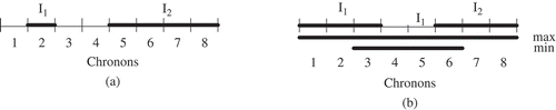
For simplicity, we assume time as isomorphic to a natural number in this study as a result that time is linearly ordered. shows the crisp time point I1 and the fuzzy time point I2. As discussed (Oliboni and Pozzani Citation2008), a fuzzy time point is described by a lower support, an upper support, and a probability function. The supports are chronons that delimit the location of the time point. In , I1 and I2 denote the fuzzy starting and ending time points of the fuzzy time interval. The fuzzy time interval can be combinations of all starting time points and all ending time points. The membership function returns the degree to which an arbitrary chronon is part of the time interval.
FIGURE 1 (a) Crisp (I1) and fuzzy (I2) time points, (b) fuzzy time interval.
Fuzziness in Position
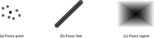
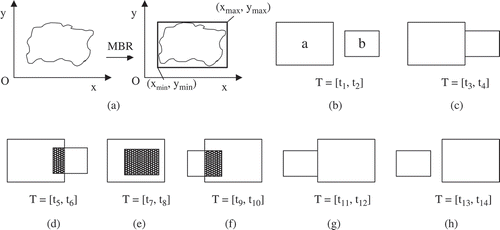
Fuzziness in position contains fuzziness in point, fuzziness in line, and fuzziness in region (Sözer et al. Citation2008). A fuzzy point is a point whose exact position is not determined but possible positions are known within a certain area. A fuzzy line is a line, the exact shape, position, or length of which is not known, but it is known in which area the line must be. The semantic of a line is a point set between two ending points. A fuzzy region is a region with indeterminate boundaries. shows fuzzy point, fuzzy line, and fuzzy region, among which the black parts indicate the exact expected positions and the grey parts indicate the possible positions. For simplicity, we talk about only two-dimensional regions without holes. Fuzzy regions are represented by MBR so that we can use two fuzzy points to represent fuzzy regions.
FIGURE 2 Spatiotemporal position types.
Fuzziness in Motion
In fuzzy spatiotemporal data, motion may be fuzzy that contains motion direction and motion value. Fuzzy motion direction denotes that the motion is not determined and may be any direction. For example, a cloud may be gone with the wind to any direction as a result that the motion direction of the cloud is not determined. Fuzzy motion value actually denotes the velocity of a spatiotemporal data. Take a cloud for example; the motion value may be different according to the wind power because the motion value is not determined.
THE FUZZY XML MODEL OF SPATIOTEMPORAL DATA
In this section, we first propose fuzzy XML spatiotemporal data model. Then, the fuzziness in an XML document is investigated and the representation of fuzzy spatiotemporal data in an XML document is proposed. Finally, we focus on XML schema and develop the extended XML schema for the fuzzy spatiotemporal data in the XML document.
Fuzzy XML Spatiotemporal Data
Because an XML document is a labeled, ordered, rooted tree, we regard a spatiotemporal data as a structured tree for metadata. As a result, operations between spatiotemporal data are actually operations between trees. According to the nature of spatiotemporal data, we give the definition of fuzzy XML spatiotemporal data (Bai, Yan, and Ma Citation2013).
Definition 1. Fuzzy XML spatiotemporal data
Fuzzy spatiotemporal data F is a 5-tuple, FSP = (OID, ATTR, FP, FM, FT), where
OID is the changing history of the spatiotemporal data.
ATTR is fuzzy attributes of spatiotemporal data.
FP is fuzzy position of spatiotemporal data.
FM is fuzzy motion of spatiotemporal data.
FT is fuzzy time of spatiotemporal data.
In the definition above, FP, FM, and FT are discussed in “Preliminaries.” Consequently, we talk mainly about OID and ATTR in the following.
Changes of OID depict spatiotemporal objects change into other spatiotemporal objects. It can not only represent changing types of objects (i.e., creation, split, mergence, and elimination) but also can represent objects that come from objects (i.e., predecessor) and change into objects (i.e., successor). We assume that the predecessor and successor of the spatiotemporal object are not fuzzy if known, because we believe that the knowledge of fuzzy predecessor and successor are not necessary and perhaps redundant if they are fuzzy. In that case, we assign the membership degree 1.0 to all membership function values of nodes in OID.
For simplicity, we use ATTR to describe attributes of the spatiotemporal data. Actually, it describes static attributes rather than dynamic attributes. There may be one or more attributes in a spatiotemporal data, and the attributes may be fuzzy. As to fuzzy attributes of the spatiotemporal data, we use possibility distribution to denote it.
Take real-life fire behaviors for example: (a) an OID will be assigned to the fire for identification, and it can represent the changing history of the fire. For instance, if fire a changes into fire b and c, the changing type of fire b or c is split, the predecessor of fire b or c is a, and the successors of fire b or c is Ø (b) the fire may have multiple attributes such as fire name, area, etc. Those attributes might have multiple values so that they may be fuzzy. (c) the fire has position information and we use MBR to represent it; (d) our model can record motion information when the fire spreads; (e) time of the fire depicts the state of the fire, and the state might be constant for a while or just happen at one time point. Of course, time can also be fuzzy. For example, the fire stays in this area this moment, and will leave this area later.
Representation of Fuzzy Spatiotemporal Data in XML Document
XML can represent fuzzy information naturally because XML data are structured. In XML documents, we may have membership degrees associated with elements and possibility distributions associated with attribute values of elements. In this subsection, we investigate how to represent fuzzy XML spatiotemporal data in an XML document.
The basic data structure of a fuzzy XML document is the data tree. We start by introducing the XML data tree (Bai et al. Citation2013).
Definition 2. Fuzzy spatiotemporal data tree
For the fuzzy XML spatiotemporal document, we have , including
is a finite set of vertices.
τ is a set of labels.
For the node
Take real-life fire behaviors for example: (a) elements of a fire are represented as vertices in its fuzzy XML spatiotemporal documents; (b) edges connecting those vertices are directed trees; (c) times of those vertices are assigned to their edges; (d) the depth of fire node is 1, and the depth of its child nodes adds 1. The rest of the nodes can be done in the same manner; (e) fire elements in the fuzzy XML spatiotemporal document preserves the fixed order; (f) all fire elements’ names contain a set of labels; (g) not all the elements in the fuzzy XML spatiotemporal documents have values; (h) elements of fire may be fuzzy, such as attributes and position information; (i) attributes of fire may be fuzzy.
On the basis of fuzzy spatiotemporal data tree as defined, characteristics of two fuzzy spatiotemporal data trees are investigated in the following.
Definition 3
Suppose and
are two fuzzy data trees as shown in Definition 2. Let f be a subtree of F, written f ∝ F, when
if
℘’, ξ’ and τ’ indicate the restriction of ℘, ξ and τ to the nodes in V’, respectively.
Definition 4
Let fuzzy data trees be the subtrees of
. Then f1 and f2 are isomorphic (recorded
), when
There is a one-to-one mapping,
Theorem 1
Fuzzy data tree F and its subtree f are isomorphic.
The proof of this theorem follows analysis of fuzzy spatiotemporal data tree and the corresponding definitions. Our model considers a number of XML features such as the ordering, the ancestor-descendant relationship of nodes in the XML document. In addition, we consider attribute nodes as a special kind of element nodes. The spatiotemporal data tree and the corresponding definitions are foundations to study how to represent fuzzy XML spatiotemporal data model in the XML document. In the following, we will define how to represent each part of the fuzzy XML spatiotemporal data in the XML document (Bai et al. Citation2013).
Definition 5
For the fuzzy XML spatiotemporal data FSP = (OID, ATTR, FP, FM, FT) and the fuzzy spatiotemporal data tree , we have
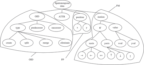
Here, “˜” means referring to or having relationship with. Take the first one, for example, it means OID in the fuzzy XML spatiotemporal data model has a relationship with V, ψ, T, , ℘, τ, ξ in the fuzzy spatiotemporal data tree. Others can get to know in analogously. shows the relationship of element nodes of spatiotemporal data that
and ℘ preserve. It depicts he relationships of nodes in OID, ATTR, FP, and FM.
FIGURE 3 Structure of OID, ATTR, FP, and FM in spatiotemporal data.
gives a fragment of an XML document with fuzzy spatiotemporal information. It is apparent that the value of a possibility attribute denoted Poss is an element of [0, 1]. The possibility attribute is applied together with a fuzzy construct called Val to specify the possibility of a given element existing in the XML document.
FIGURE 4 A fragment of an XML document with fuzzy spatiotemporal data.
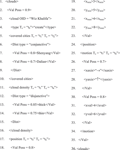
Consider Line 3 of , <Val Poss = 0.9>, where it is stated that the possibility of a given element cloud OID being “Wiz Khalifa” is equal to 0.9. As to ATTR, we introduce another fuzzy construct called Dist to specify a possibility distribution. Lines 6–9 are the conjunctive Dist construct for cities covered by cloud “Wiz Khalifa” because the cloud may cover multiple cities simultaneously. Lines 12–15 are the disjunctive Dist construct for cloud density of cloud “Wiz Khalifa” because the cloud density is unique. Lines 17–24 indicate the position of the cloud. From lines 19–22, we can see the cloud is taken as a fuzzy region that the two represented points of MBR are (3, 5) and (6, 8). Line 18 and line 23 indicate that the possibility of the cloud’s position equals to 0.8. Lines 25–34 indicate the motion of the cloud. Lines 27–28 specify the motion trend of the cloud. Line 26 and line 29 indicate that the possibility of the cloud’s direction equals to 0.7. Lines 31–32 specify the motion change value of the cloud. Line 30 and line 33 indicate the possibility that the cloud’s motion value equals to 0.8. Finally, we consider time. Line 4–5, line 11, line 17, and line 25 contain time information. It is noted that Ts and Te in each line may be fuzzy time. Time in line 4 states the cloud creating as “Wiz Khalifa” at time t0. The changing type is not fuzzy as a result that t0 is crisp. Time in line 5, 11, 17 state their valid time being [t1, t2], [t3, t4], and [t5, t6]. Time in line 25 constrains two attributes of the motion. It states the changing trend and the changing value are lines 27–28 and lines 31–32, respectively, between t7 and t8. Here, t1 to t8 may be fuzzy.
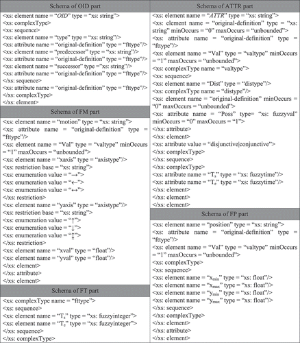
The Schema Definitions
It has been shown that the traditional XML schema definitions should be extended to accommodate fuzzy spatiotemporal data. In this subsection, we aim to extend XML schema to incorporate fuzzy spatiotemporal information.
As the structure of fuzzy spatiotemporal data model mentioned above, we investigate the schema definitions from OID, ATTR, FP, FM, and FT view points. shows the schema definitions of these five parts: (a) for the OID part, we consider changing type as crisp as well as predecessor and successor. As a result, there are no possibility distributions (omitted) with these three elements. The schema definition defines elements and attributes in OID and their order. Note that “original-definition” is a general name, which can be replaced by an exact name in the XML document. In addition, “fttype” indicates fuzzy time type, which is defined later. (b) For the ATTR part, there are two types of possibility distributions, which are disjunctive and conjunctive. We define each of them, and define Dist using to specify the types of possibility distributions. As to Poss, it is quite straightforward that the value of it is [0, 1]. (c) For the FP part, the schema defines MBR of the spatiotemporal data If we want to represent a fuzzy point, we can replace the sequence part by “xl” and “xr”. (d) For the FM part, we define schema of motion direction and changing value, respectively. As for the value of the motion direction, there are only three that are enumerated. (e) For the FT part, it may occur in the other four parts. It contains two attributes denoted as Ts and Te, representing the starting and ending time points. It is noted that their type are “xs: fuzzy interger,” which means Ts and Te are fuzzy integers as we assume time as isomorphic to a natural number.
FIGURE 5 Schema definitions of fuzzy spatiotemporal data.
FUZZY OPERATIONS
Fuzzy operations contain mainly node operations and topological relationship operations. In this section, we propose how to carry out these fuzzy operations.
Node Operations
This subsection presents the issues on how to operate nodes in an XML document. We talk about three node operations: fuzzy union (∪), fuzzy intersection (∩), and fuzzy difference (–). First, we will give the general algorithms for node operations.
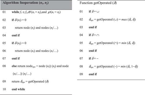
Algorithm fnoperation (ni, nj) is used to operate two nodes between two different spatiotemporal data, which are actually two different trees. The major premise of the algorithm is that the two trees are isomorphic and the two nodes have the same depth and order in those two trees. In this algorithm, it returns the node as well as its descendents (maybe the nominal ones in the XML document). We illustrate each case with examples.
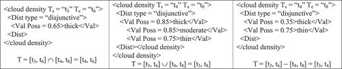
shows two fuzzy XML trees at different time intervals. According to Definition 4, these two fuzzy trees are isomorphic. Thus, we can operate these two trees using the algorithm fnoperation. We operate them on “∩,” “∪,” and “–,” respectively. shows the fuzzy operation results of those three operations. In the fuzzy intersection, the result available in the time interval [t4, t6] has only one possibility because the other two possibilities are zero, which is omitted. In the fuzzy union, the result available in the time interval [t3, t8] has all possibilities appearing in the original two trees. In the fuzzy difference, the result available in the time interval [t3, t4] has two possibilities. According to the algorithm, descendents of the cloud density node for each operation, which are dist and val in the XML document, are returned.
FIGURE 6 Fuzzy nodes available in two different time intervals.
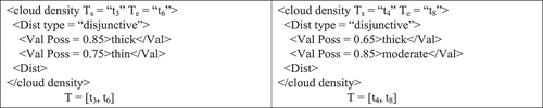
FIGURE 7 Fuzzy operation results of nodes.
Topological Operations
Spatiotemporal topological operations contain spatiotemporal disjoint, spatiotemporal meet, spatiotemporal intersect, spatiotemporal contain, spatiotemporal overlap, and spatiotemporal equal. They are denoted as stDisjoint, stMeet, stIntersect, stContain, stOverlap, stEqual, respectively. In the following, we will first propose algorithms for determination of these six topological operations.
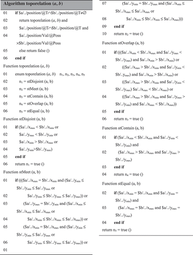
Algorithm toporelation could not only return the topological relationship but also could return at which time interval the topological relationship holds and the possibility of this topological relationship. Function toporelation enumerates five topological relationships. Note that there is no stIntersect because it is a special case of stOverlap; the former deals with a 1D spatiotemporal data with another 2D spatiotemporal data, and the latter deals with two 2D spatiotemporal data. With respect to the five topological relationship functions, we consider only one situation: which spatiotemporal a is taken as reference. Because spatiotemporal a and b are symmetric, we can easily extend it to the other situation. In the following, we use an example to illustrate the algorithm.
shows the topological relationship of two clouds changing over time. reveals that the cloud is presented by MBR because it is 2D spatiotemporal data. For simplicity, we assume the shape of these two clouds is maintained constant because we talk mainly about the topological relationship and the shape dynamically is not necessary. to indicate the topological relationship of the two clouds in seven time intervals, respectively. We use δθ.T to denote the membership degree of position of the spatiotemporal data θ being δ at the time interval T. For example, in , the membership degree of position of spatiotemporal data a is δa.[t1, t2], whereas the membership degree of position of spatiotemporal data b is δb.[t1, t2]. As to δθ.T, we can compute by multiplying, assuming the two spatiotemporal data are independent. In these seven cases, we first call the function toporelation. In the function toporelation, we should call five topological relationship functions. For example, and return n1 which means that the topological relationship is stDisjoint. and return n2, which means that the topological relationship is stMeet. and return n4, which means that the topological relationship is stOverlap. returns n3, which means that the topological relationship is stContain. After returning the topological relationship, it should also return the time interval and the possibility of this topological relationship holds. Line 03 of the algorithm returns the time interval and the topological relationship holds. Time intervals in , , , , are [t1, t2], [t5, t6], [t7, t8], [t9, t10], and [t13, t14], respectively. It is noted that these time intervals must be intervals, which means the starting time point and the ending time point are different. On the contrary, time intervals in and are [t3, t4] and [t11, t12], and the time interval might be a time point because the starting time point and the ending time point are the same. Line 04 of the algorithm returns the membership degree of the spatiotemporal data in this position. Because the spatiotemporal data a and the spatiotemporal data b are independent, membership degree of the topological relationship is δa.T × δb.T. In summary, we could get the topological relationship of these seven cases according to the algorithm: The topological relationship of is stDisjoint with the membership degree δa.[t1, t2] × δb.[t1, t2] at the time interval [t1, t2]; the topological relationship of is stMeet with the membership degree δa.[t3, t4] × δb.[t3, t4] at the time interval [t3, t4]; the topological relationship of is stOverlap with the membership degree δa.[t5, t6] × δb.[t5, t6] at the time interval [t5, t6]; the topological relationship of is stContain with the membership degree δa.[t7, t8] × δb.[t7, t8] at the time interval [t7, t8]; the topological relationship of is stOverlap with the membership degree δa.[t9, t10] × δb.[t9, t10] at the time interval [t9, t10]; the topological relationship of is stMeet with the membership degree δa.[t11, t12] × δb.[t11, t12] at the time interval [t11, t12]; the topological relationship of is stDisjoint with the membership degree δa.[t13, t14] × δb.[t13, t14] at the time interval [t13, t14].
FIGURE 8 Topological relationship of two clouds in seven time intervals.
Other Operations
In addition to node operations and topological operations, there are several other operations such as distance, area, perimeter, etc. All those operations can be carried out by computing the values of their position nodes.
For example, assuming ni and nj are root nodes of two fuzzy spatiotemporal data, then distance (ni, nj) can be computed by center points of their MBRs; area (ni) and perimeter (ni) can be computed by each ending point of its MBR. Because these computing methods are based on mathematical formulas, we do not further investigate them in this article.
APPLICATION IN METEOROLOGICAL EVENTS
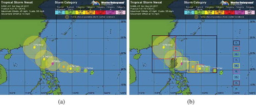
In order to show validation of the model, we apply it to meteorological events and show how to use our model to record and operate fuzzy spatiotemporal data. shows the predicted track of tropical storm Nesat recorded at 9 AM JST on September 24, 2011 (Macao Meteorological Web Citation2011). It records the states of Nesat on seven time points as shown in . Each circle in represents an affected area of Nesat on a time point, and the dots in the centers of circles show possible storm center locations. Not concerned with whether the prediction track is accurate, in the following we will show how to use our model in this application in detail.
Step 1: Extract spatiotemporal information data and classify them into five types according to Definition 1.
FIGURE 9 Track of tropical storm Nesat.
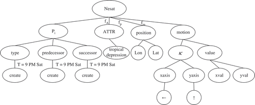
First, we consider Pi as OID because it is, by nature, a tropical storm and it is unique (Pi is shown in and i = 1, 2, …, 8). As for changing type, Nesat is created at 9 PM on Saturday. The ATTR of the spatiotemporal data can be multiple, and we consider only tropical depression in this example for simplicity. For the FP part, we can use longitude and latitude to record the position of Nesat. In , we depict eight MBRs to represent the possible tropical storm Nesat areas denoted P1 to P8. For the FM part, we can see from that the motion direction of Nesat is “←” and “↑”, and the changing value along the x-axis and y-axis can be computed by the real-time value. Finally, for the FT part, the recorded time is crisp so that the FT part at the seven time points are also crisp. However, for the time between the recorded times, they are fuzzy, so a membership function is needed to measure the fuzzy time.
Step 2: Construct fuzzy spatiotemporal data tree according to Definition 2.
shows the constructed fuzzy spatiotemporal data tree. Note that we mark temporal information only in the OID part because Nesat is considered to be created at the marked time point and other temporal information standing between 9 PM Sat and 9 PM Wed is omitted for simplicity. In addition, for the membership function, we consider the membership function an attribute of the nodes. As a result, they are shown at the temporal mark positions. As shown in , ATTR, position, and motion may be fuzzy so that each edge incident is added to them with the membership functions f.
FIGURE 10 Constructed fuzzy spatiotemporal data tree.
Step 3: Extend schema definitions to accommodate fuzzy spatiotemporal data according to investigation in “The Schema Definitions.”
We can extend them from OID, ATTR, FP, FM, and FT points of view as investigated in “The Schema Definitions.”
Step 4: Operate spatiotemporal data.
After processing the first three steps, we can query fuzzy spatiotemporal data by operating. Query examples are listed in three cases: node operation, topological operation, and attribute operation.
Node operation: Retrieve the affected area of Nesat from 9 PM Sat to 9 PM Wed. This query is formulated using XQuery as follows:
for $a in doc (“storm.xml”)/spatiotemporal data
let $m:= $a//../position
where $m//xmin = min {$m//xmin/(@Ts = “9 PM Sat” and @Te = “9 PM Wed”) and
$m//xmax = max {$m//xmax/(@Ts = “9 PM Sat” and @Te = “9 PM Wed”) and
$m//ymin = min {$m//ymin/(@Ts = “9 PM Sat” and @Te = “9 PM Wed”) and
$m//ymax = max {$m//ymax/(@Ts = “9 PM Sat” and @Te = “9 PM Wed”)
return $m//xmin, $m//xmax, $m//ymin, $m//ymax, $m//xmin/@Poss, $m//xmax/@Poss, $m//ymin/@Poss, $m//ymax/@Poss
The query corresponds to node operation, and would return the coordinate of the two ending points of MBR as well as their possibility value according to the algorithm fnoperation. As shown in , the affected area is represented as P1 and the possibility value can be computed by $m//xmin/@Poss × $m//xmax/@Poss × $m//ymin/@Poss × $m//ymax/@Poss assuming that the corresponding areas are independent.
Topological operation: Retrieve which tropical storm affects the Philippines (the topological relationship of P2, P3 and the Philippines is stOverlap). This query is formulated using XQuery as follows:
for $a, $b in doc (“storm.xml”)/spatiotemporal data
let $a:= “P2”
let $b:= “P3”
let $c:= “MBR of Philippines”
let $d:= function toporelation (a, b)
where call function toporelation (a, c) and call function toporelation (b, c)
return $d, $a/../position/Val/@Poss, $b/../position/Val/@Poss
The query corresponds to the topological operation and would return the affected area in the Philippines as well as the possibility value according to the algorithm toporelation. As computed according to the algorithm proposed and as shown in , the affected area, whose topological relationship of “P2”, “P3” and “MBR of Philippines” is stOverlap, is P9 as shows (the area with dashed lines) and the possibility value can be computed by $a/../position/Val/@Poss × $b/../position/Val/@Poss assuming that the corresponding areas are independent. It is noted that the area of the Philippines is determinate so that $c/../position/Val/@Poss = 1, which is omitted.
Attribute operation: Retrieve the tropical storm Nesat, whose tropical depression is 80 mph–100 mph from 9 PM Sat to 9 PM Wed (in order to consider the tropical depression intuitively, we exact the tropical depression information from and show it in ). This query is formulated using XQuery as follows:
FIGURE 11 Tropical depression of Nesat.

for $a in doc (“storm.xml”)/spatiotemporal data and
$a/@Ts = “9 PM Sat” and @Te = “9 PM Wed”
let $m:= $a/ATTR
where min $m/tropical depression = 80 and max $m/tropical depression = 100
return $a and $a/.. = $m
The query would return the tropical storm Nesat, whose tropical depression is 80 mph–100 mph from 9 PM Sat to 9 PM Wed. As shown in , P2, P3, P5, P6 are returned. In addition, possibility distributions of P2, P3, P6 are 0.75, and possibility distribution of P5 is 0.25 assuming that it is the uniform distribution.
CONCLUSION
In the scope of this work, a novel fuzzy spatiotemporal data model is proposed based on XML. Then, we analyze representation of fuzzy spatiotemporal data in XML documents and extend the XML schema to accommodate fuzzy spatiotemporal data. Algorithms for fuzzy node operations and fuzzy topological relationship operations are proposed. Finally, four steps are introduced to apply our model in meteorological events, which demonstrate that our model is feasible and available and can support spatiotemporal applications.
Modeling fuzzy spatiotemporal data in XML requires further research. More specific and complex fuzzy operations based on our model should be investigated. In addition, representation of fuzzy spatiotemporal position using MBR is not accurate, so we would like to improve our approach for depicting the area of fuzzy spatiotemporal accurately.
FUNDING
This work was supported by the National Natural Science Foundation of China (60873010, 61073139, 61370075 and 61402087), the Fundamental Research Fund for the Central Universities (N130323006), the Scientific Research Fund of Hebei Education Department (QN2014339), and the Doctoral Fund Project of Northeastern University at Qinhuangdao (XNB201428).
Additional information
Funding
Related Research Data
REFERENCES
- Abiteboul, S., S. Quass, J. McHugh, J. Widom, and J. Wiener. 1997. The Lorel query language for semistructured data. International Journal on Digital Libraries 1(1):68–88.
- Baazizi, M. A., N. Bidoit, and D. Colazzo. 2011. Efficient encoding of temporal XML documents. In Proceedings of the 18th International Symposium on Temporal Representation and Reasoning, 15–22. IEEE.
- Bai L., L.Yan, and Z. M. Ma. 2013. Determining topological relationship of fuzzy spatiotemporal data integrated with XML twig pattern. Applied Intelligence 39(1):75–100.
- Claramunt, C., and M. Theriault. 1995. Managing time in GIS: an event-oriented approach, In Proceedings of the international workshop on temporal databases: Recent advances in temporal databases, 142–161. The Netherlands: Kluwer.
- Cobb, M. A., and F. E. Petry. 1998. Modeling spatial relationships within a fuzzy framework. Journal of the American Society for Information Science 49(3):253–266.
- Deutsch, A., M. Fernandez, D. Florescu, A. Levy, and D. Suciu. 1999. A query language for XML. Computer Networks 31(11):1155–1169.
- Franceschet, M., A. Montanari, and D. Gubiani. 2007. Modeling and validating spatio-temporal conceptual schemas in XML schema. In Proceedings of the 18th international conference on database and expert systems applications, 25–29. Washington, DC, USA: IEEE Computer Society.
- Goncalves, M., and L. Tineo. 2010. Fuzzy XQuery. In Soft computing in XML, Data Management Studies in Fuzziness and Soft Computing, 133–163. Berlin: Springer-Verlag.
- Graurav, A. and R. Alhajj. 2006. Incorporating fuzziness in XML and mapping fuzzy relational data into fuzzy XML. In Proceedings of the 2006 ACM symposium on applied computing, 456–460. New York, NY: ACM.
- Huang, B., S. Yi, and W. T. Chan. 2004. Spatio-temporal information integration in XML. Future Generation Computer Systems 20(7):1157–1170.
- Liu, X. H., and Y. C. Wan. 2010. Storing spatio-temporal data in XML native database. In Proceedings of the 2nd International Workshop on Database Technology and Applications, 1–4. New York, NY: ACM.
- Ma, Z. M., J. Liu, and L. Yan. 2010. Fuzzy data modeling and algebraic operations in XML. International Journal of Intelligent Systems 25(9): 925–947.
- Ma, Z. M., and L. Yan. 2007. Fuzzy XML data modeling with the UML and relational data models. Data & Knowledge Engineering 63(3):972–996.
- Macao Meteorological Web. 2011. Available at http://macaoweather.weebly.com.
- Mane, A., D. R. Babu, and M. C. Anand. 2004. XML representation of spatial data. In Proceedings of the IEEE India annual conference, 490–493. IEEE.
- Mitakos, T., and I. Almaliotis. 2009. Representing geographic information in multidimensional XML. In Proceedings of the 16th international conference on systems, signals and image processing, 1–4. IEEE.
- Mendelzon, A. O., F. Rizzolo, and A. Vaisman. 2004. Indexing temporal XML documents. In Proceedings of the 30th international conference on very large data bases, 216–227. New York, NY: ACM.
- Noh, S. Y., and S. K. Gadia. 2005. An XML-based framework for temporal database implementation. In Proceedings of the 12th international symposium on temporal representation & reasoning, 180–182. IEEE.
- Oliboni, B., and G. Pozzani. 2008. Representing fuzzy information by using XML schema. In Proceedings of the19th international conference on database and expert systems applications, 683–687. Washington, DC: IEEE Computer Society.
- Pelekis, N., B. Theodoulidis, I. Kopanakis, and Y. Theodoridis. 2004. Literature review of spatio-temporal database models. The Knowledge Engineering Review 19(3):235–274.
- Pfoser, D., and C. Jensen. 1999. Capturing the uncertainty of moving-object representations. In Proceedings of the 6th international symposium on spatial databases, 111–132. London, UK: Springer.
- Pfoser, D., and N. Tryfona. 1998. Requirements, definitions, and notations for spatiotemporal application environments, In Proceedings of the 6th ACM symposium on geographic information systems, 124–130. New York, NY: ACM.
- Pfoser, D., and N. Tryfona. 1999. Capturing fuzziness and uncertainty of spatiotemporal objects. In Proceedings of the 5th east European conference on advances in databases and information systems, 111–132.
- Rizzolo, F., and A. A. Vaisman. 2008. Temporal XML: modeling, indexing, and query processing. The VLDB Journal 17(5):1179–1212.
- Salamat, N., and E. H. Zahzah. 2010. Fuzzy spatio-temporal relations analysis. In Proceedings of the seventh international conference on information technology, 301–306. Washington, D.C.: IEEE Computer Society.
- Stefanakis, E. 2001. A unified framework for fuzzy spatio-temporal representation and reasoning. In Proceedings of the 20th international cartographic conference, 2678–2687. ICA-ACI.
- Sözer, A., A. Yazici, H. Oğuztüzün, and O. Tas. 2008. Modeling and querying fuzzy spatiotemporal databases. Information Sciences 178(1):3665–3682.
- Su, L. H., Y. X. Huang, X. W. Li, and G. L. Tian. 2001. Spatial data and model management based on XML. In The international symposium on geoscience & remote sensing, 1951–1952. Springer.
- Tryfona, N., and T. Hadzilacos. 1995. Geographic applications development: models and tools at the conceptual level. In Proceedings of ACM-GIS, 178–192. ACM.
- Yan, L., Z. M. Ma, and J. Liu. 2009. Fuzzy data modeling based on XML schema. In Proceedings of the 2009 ACM symposium on applied computing, 972–996. New York, NY: ACM.
- Yazici, A. and R. George. 1999. Fuzzy database modeling. Heidelberg, Germany: Physica-Verlag.
- Zadeh, L. A. 1965. Fuzzy sets. Information and Control 8(3):338–353.