Abstract
The American scientist, explorer, and conservationist John Wesley Powell (1834–1901) represents, in many ways, a counter to 19th-century imperialism in the arid West: an approach to westward expansion that was more sensitive to failure and more eager to see the West secured in the hands of a self-organized agrarian community. Toward that end he sponsored a mapping project to show how settlement might be based on watershed alignments and conserve the vital resources of the region. That projects is still relevant to nations that are trying to understand how to govern their relations with the natural environment.
Where does the American West begin? Out where the sky seems to get bigger and bigger, where the grass gets shorter and browner, where the air gets drier until your skin begins to tighten and your eyes begin to squint from the flood of brilliant sunlight. Nature supplies the physical conditions that we call the West – a dry, droughty place that we have tried to pack with too many people. And those people never have accepted their conditions but constantly demand, “give us more rain, give us more water.” Those conditions and that incessant demand constitute the West as physical and political geography.
But another ‘point of beginning’ lies far to the east and further back in time, back in the early days of the new American republic, long before any citizens crossed the prairies or saw any deserts. There begins the West of ideas – ideas conceived without any experience on the ground. Chief among those ideas was the dream of an American empire expanding well beyond the Mississippi River and someday realizing itself on the western side of the continent.
On the Fourth of July, 1778, just two years after the signing of the Declaration of Independence, David Ramsey, a member of the Continental Congress, offered this breathtaking vision: a free, independent nation growing westward as far as it could go. He foresaw a whole “independent continent,” covering all of North America, so big and so good that it would awe and inspire the whole world (Ramsey Citation1965, p. 185).
“The remotest depths of our national frontiers,” Ramsey predicted, will be transformed into agricultural fields, fabulous mines, and cities (p. 188). “Those very spots that are now howled over by savage beasts and more savage men” will furnish raw materials for the world's greatest empire (p. 190). As Ramsey dreamed of a West that he would never see, his heart swelled with pride and anticipation: “What a substratum for empire!” he wrote, “compared with which, the foundation of the Macedonian, the Roman, and the British, sink into insignificance”.
Pause for a moment on that phrase “substratum for empire.” An empire, Ramsey was saying, in order to grow and survive needs a large base in nature – a substratum of abundant forests, soils, waters, and minerals. Such wealth of natural resources is necessary for commerce to flourish, populations to increase, and power to accumulate. The greatest empires have been well endowed with all the vital resources – with water, for example. Without access to plentiful water, no empire could last for long.
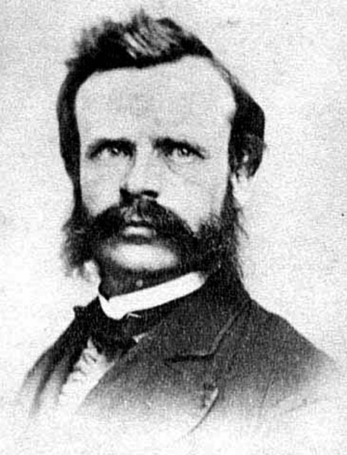
That dream of an American empire knowing no environmental constraints, realizing itself in the West, was what the nineteenth century scientist-explorer-conservationist John Wesley Powell set out to challenge (). He was a full-blown patriot in his confidence in American ideals and promise, but he was also the first prominent figure to think realistically about the nature of the West, to point to its essential aridity, and to ask what that scarcity of a vital resource might imply for settlement, progress, wealth, and power. For that reason he deserves to be remembered as our greatest prophet of environmental limits, which is to say, of the limits of empire.
Figure 1. Powell with burnsides, taken in Wheaton, Illinois, December 1869. Source: Used by Permission, Utah State Historical Society, Salt Lake City, Utah, all rights reserved.
This anti-imperial side is not often remembered. Powell's name has been emblazoned all over the map of the American West – on towns, mountains, museums, and a massive reservoir, Lake Powell – as well as on the headquarters of the US Geological Survey in Reston, Virginia. (He served as the Survey's director in its early years.) But that recognition points more to his achievements as a western explorer, finishing what Lewis and Clark had begun in opening the West to the American imagination, rather than to his realism about the limits that nature imposes on human ambitions.
Here I want to review how Powell came to that realism. I want to ask what he learned out west and whether, in this current moment of national anxiety and reappraisal, there is anything we can still learn from him.
Nothing in Powell's early years seemed to prepare him to play the role of western expert. He was born in 1834 in the heavily forested country of upstate New York, to English immigrant parents, and then was raised on a series of farms in Ohio, Wisconsin, and Illinois. For four years he served in the Civil War, leaving part of his right arm on the battlefield of Shiloh, a loss that severely disabled him for many jobs and careers and forced him for a while into teaching.Footnote1
In the summer of 1867, Powell set off with a group of Illinois undergraduates on a field trip along the Platte River, once the route of the covered-wagon pioneers. They spent that summer in the Rocky Mountains, where he first learned about the Colorado River. Government maps still labeled the entire midsection of the river and its surrounding plateau, the Grand Canyon country, as “unknown territory.” Powell boldly conceived a plan to explore that fabled river through its stonewalled canyons and to add new knowledge to American science.
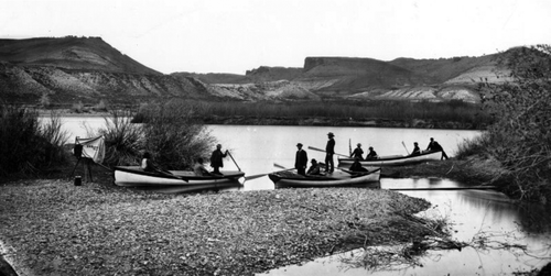
In May 1869, near the line of the just completed transcontinental railroad where it crossed the Green River in Wyoming Territory, Powell launched the Colorado River Exploring Expedition. It was privately financed for the most part, not an official government project, and there were only ten men in the crew, nine of them with no scientific credentials ().
Figure 2. Powell's second Colorado River exploring expedition at Green River City, Wyoming, May 1871. Taken by E.O. Beaman.
Source: United States Geological Survey, Federal Center, Denver, Colorado.
Through June and July the men raced their boats through deeper and deeper canyons. They lost one entire boat and its vital supplies in a dangerous stretch of water, ran through many white-water rapids, and then were forced to row and row through sluggish side-eddies until their arms ached. At twilight they huddled on a lonely sandbar to eat whatever fish or game they could catch.
By late August, the expedition had reached the Great Unknown, the Grand Canyon, and the journey had become ‘a race for life.’ Their food stores were down to a five-day supply of flour and a few pounds of apples, and they had no sure way of knowing how many more days lay before them. Three of the crew, discouraged and rebellious, abandoned the expedition and were never seen again. The rest desperately pushed on until, shaken but triumphant, they came floating out of the chasm and into the broad, silty mouth of the Virgin River – a site now buried under water impounded in Lake Mead.
Nine years after that expedition, in 1878, and exactly 100 years after David Ramsey's Fourth of July oration, Powell published his “Report on the Arid Lands of the United States.”Footnote2 He had continued exploring and mapping across the Colorado Plateau and was now prepared to issue a well-informed warning to the nation: the western side of the continent was mighty dry and would impose limits on national expansion. Developing the West, Powell pointed out, would require the techniques of irrigated farming, but less than 3% of the region could ever be irrigated because the supply of surface water was so scarce. Here was an obstacle to greatness that the Founding Fathers never anticipated.
A familiar document to most western historians, the Report's chief recommendations were that the nation's land laws should be reformed; settlers should not continue to carve up the public domain into standardized 160-acre squares of private property, a land pattern that was ill-suited to the West. Powell recommended two alternatives for land privatization: small irrigated farms organized into irrigation districts; and large “pasturage farms,” or livestock ranches, organized into grazing districts. None of the water should be privatized; it should belong as common property shared by everyone who owned land.
“The eastern portion of the United States,” Powell wrote, “is supplied with abundant rainfall for agricultural purposes, […] but westward the amount of […] precipitation diminishes […] until at last a region is reached where the climate is so arid that agriculture is not successful without irrigation" (Powell Citation1878, p. 1).
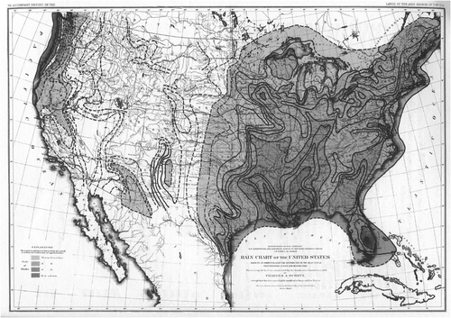
Powell based this generalization not only on his own experience – years spent in boats, in saddles, and on foot – but also on a Smithsonian Institution's rain chart that showed that, aside from a humid coastal strip running north of San Francisco toward Seattle and a few well-watered mountain slopes, the West received less than 20 inches of rainfall per year on average ().Footnote3 Twenty inches of rainfall is the minimum amount needed for raising the major grains, fruits, and vegetables on which Americans fed. When annual precipitation falls below that level, none of those domesticates can flourish except with the aid of artificial irrigation and then only in a few places.
Figure 3. Rain chart of the United States, by Charles A. Schott (1868), reprinted in Powell (1879), frontispiece.
Congress mainly ignored Powell's proposals, and nothing came of them. The typical homestead remained the standardized 160-acre parcel, though eventually Congress doubled and then quadrupled the standardized allotment to cope with aridity.
Following his failure to get his reforms adopted, Powell did not give up. During the decade of the 1880s he worked them over into an even more radical vision – a master plan for the West that was breathtaking in its boldness. It was a response not only to the aridity of the West but also to the post-Civil War economic forces that were sweeping into the region, as they were sweeping across the nation. Enterprising citizens were everywhere looking for resources to exploit, stuffing into their pockets as much wealth as they could grasp. The challenge, as Powell saw it, was to save the West for the mass of people before it was permanently lost to the aggressive few.
A limited supply of water can easily be monopolized, and a monopoly over such a vital necessity would put the common people at risk. How to keep that limited supply in the hands of as many as possible, how to make sure that the principles and values of democracy survive in a land of environmental limits, was the great challenge that must be met. “If in the eagerness for present development,” Powell warned,
a land and water system shall grow up in which the practical control of agriculture shall fall into the hands of water companies, evils will result […] that generations may not be able to correct, and the very men who are now lauded as benefactors to the country will […] be denounced as oppressors of the people. (Powell Citation1878, p. 1)
A real democracy requires more than political campaigns and elections, more than a set of rituals or even the right ideas or philosophy. It needs a secure material foundation. It needs enough land and resources to go around, and these must be distributed as widely and fairly as possible. That had not seemed like a problem in the eastern states, where abundant soil and water were easily found. But what would be the fate of democracy when the nation moved farther west, when it arrived in a less generous land? How could it sustain democracy when there were more people pressing on less water, soil, or forest?
Powell's ultimate plan for the region was to create a new political system based on the watershed, that is, on the waterways that flow through the countryside and the land that supplies that water. Those watersheds should become the definition of, the foundation for, local and regional government. Within each watershed there should be a polity of citizens armed with knowledge to develop the watershed for the common good and to make rules governing its use.
The first step toward that goal, Powell believed, was to observe and respect the patterns that water makes as it flows across the landscape. In nature, water does not flow in straight or rigid lines but cuts a far more complicated pattern – a mosaic of thousands of interlacing rivers and streams, each one different from all the others. Yet each watershed is a unified whole in which everything, from one divide to the other, is bound together by commonalities of geology, rainfall, evaporation, soil absorption, runoff, and drainage. Vegetation is part of that unity, likewise the fauna, and likewise the people who live there.
Powell recommended that the government begin surveying and dividing the West, not acre by acre, but watershed by watershed, and require that each community plan how it would use all the resources with its boundaries. Where there were forests on the upper slopes, settlers should draw up rules for their protection and use. At mid elevations, settlers should set up community pastures with rules for grazing livestock and protecting soils from erosion. Only the arable bottomlands, down where the creeks and rivers run, down where people could irrigate a patchwork of crops, should be divided into private estates, and even there the water should be communally owned and conserved.
Learning to live carefully within one's watershed required first being able to see it. We see forests or hills easily enough, or rivers running through meadows. But seeing the whole watershed requires more information – it requires knowledge. When Powell became director of the US Geological Survey, which in the late nineteenth century was the federal government's premier scientific research agency, he put scientists to work mapping the topography of the West and then mapping the rest of the United States. Those maps, he hoped, would help citizens know their watershed better. They would help people visualize America's geography, its natural divisions, its networks of streams and rivers.
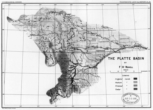
shows the map for the western United States that the Survey published in its Eleventh Annual Report, 1890–91. Note that all the state boundaries so familiar today have disappeared. Instead, we see a patchwork of colors – shades of red, green, brown, and yellow denoting the great watersheds – a map that was supposed to show citizens how the West looked from the perspective of running water. A larger-scale map from the Survey's Thirteenth Annual Report, 1892–93, detailing one of those watershed unities, the Platte River Basin of Wyoming and Nebraska appears in . Here the colors (indicated by shades of gray in this version) suggest which lands should be conserved as forests, which should be used as rangelands, and which (the small dark spots) should be reserved for irrigated farms and settlements.Footnote4
Figure 4. Map of the arid region of the United States showing drainage districts. Eleventh annual report of the United States Geological Survey, 1890–91. In Report of the Secretary of the Interior, 51st Cong., 2nd sess., House Executive Document 1, part 5, serial set 2844.
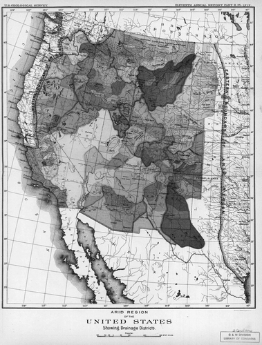
Figure 5. Map of the Platte Basin by F. H. Newell, in Thirteenth annual report of the United States Geological Survey, 1892–93. In Report of the Secretary of the Interior, 52nd Cong., 2nd sess., House Executive Document 1, part 5.
In the early months of 1890, nearly 20 years after he had first explored the Colorado, Powell ran a geographical seminar for politicians on understanding the West. The House Select Committee on the Irrigation of Arid Lands was holding hearings on a bill to turn the arid lands over to the states and territories, the first of many such efforts by western politicians to gain control of the public domain. As the foremost authority on those lands, Powell came to testify and brought along his agency's maps to hang before them on the wall. He intended to teach the congressmen the underlying logic of the landscape, valley by valley, and to suggest how a brand-new political system might be derived from observing and following that logic. He wanted his audience to know the country as he knew it, visualizing it from high up on the canyon rims and also down there on the river. He wanted them to realize how little of the country could ever grow crops and how even that little acreage would require a considerable investment in storage reservoirs. He wanted the legislators to appreciate the conflicts that were already brewing in western valleys, as upstream developers diverted water that downstream farmers had depended on. Above all, he wanted them to see that all the natural resources of the West were connected in a single whole, so that what was done to the mountain forests affected the lowland streams and how the vast expanse of lands without water were dependent on the few areas with water.
Powell was, in effect, arguing against the proposed bill, for he did not think it wise to surrender any part of the public domain to the states without more careful planning. Already, arbitrary state and county boundaries that made no environmental sense were endangering that planning. Powell argued that Congress and the states should start with a completely new set of governmental units based on what he called “hydrographic basins,” that is, catchment basins or watersheds – political units defined by topography and the flow of water:
This, then, is the proposition I make: that the entire arid region be organized into natural hydrographic districts, each one to be a commonwealth within itself for the purpose of controlling and using the great values which have been pointed out. […] The plan is to establish local self-government by hydrographic basins. (Powell Citation1890, p. 115)Footnote5
Powell had plotted on his maps the outlines of 140 such units in the West, each of them approximately the size of two eastern counties. Within each unit the preponderance of land would become community property. Formal title could remain in federal hands, but the local people would have the use of them and would make the rules for their management. “If they want that timber destroyed,” Powell said, “if they want to sell it, if they want to destroy it and wipe out irrigation, they are responsible for it, and let them do as they please” (Powell Citation1890, pp. 113–114).
That might have sounded as though Powell would turn the West over to the grabbers and gougers, the cut and run band of ruthless entrepreneurs. But the ‘them’ that Powell had in mind was not the ‘them’ of laissez-faire, free-enterprise America, where individuals were encouraged to pursue their self-interest with indifference toward the welfare of others, where dog ate dog and the ‘fittest’ survived. His ‘them’ was a more communitarian society that would exercise responsibility for making rules to govern the use of land and water. There were more alternatives than either laissez-faire free-for-all or a strong outside force like the government.
* * * * *
East of the plains and mountains, the pursuit of an American empire had not seemed to require much aid from the federal government. Private individuals, working alone for the most part, had managed to create an economic powerhouse without much government direction. In this aspect the United States was historically unique; no other empire in history had grown with so little government direction. Whenever private enterprise proved inadequate, a state legislature managed to step forward and carry out the work of conquest: the state of New York, for example, built the Erie Canal to promote commercial expansion, a project that allowed the self-proclaimed ‘Empire State’ to flourish.
For a while that strategy of development based on free enterprise with limited state assistance seemed possible in the arid West as well. Small farmers and ranchers or small colonies managed to divert water from the side creeks and raise a little food or alfalfa without any outside capital or expertise or without much cooperation with their neighbors. Traditionalists insisted that nothing had changed, that aridity did not pose any problem to westward expansion. The West would be easily added to that “substratum of empire,” and in fact would become the new seat of American power.
Here is Secretary of the Interior John W. Noble writing in 1893:
I have no fear that America will grow too big. A hundred years hence these United States will be an empire, and such as the world never before saw, and such as will exist nowhere upon the globe. In my opinion the richest portion of it, and a section fully as populous as the East, will be in the region beyond the Mississippi. All through that region, much of which is now arid and not populated, will be a population as dense as the Aztecs ever had in their palmiest days in Mexico and Central America. Irrigation is the magic wand which is to bring about these great changes. (qtd. in Worster Citation1985, p. xi)
Even as Powell was speaking, a new role for the federal government was emerging that would put it in charge of developing western water, land, and other resources. In 1891, Congress set aside the first federal forest reserves, 11 million acres that would one day increase to a national forest system covering nearly 200 million acres. Similar proposals for federalizing the West would lead to the Bureau of Reclamation in 1902 and the Bureau of Land Management in 1946. As protective measures, these were imperialistic, but protection would eventually give way to policies of economic development intended to enhance the nation's wealth and power.
Make no mistake: such federalization was not Powell's approach. The government, he felt, should not cede its lands to the states, but neither should it set up a centralized bureaucracy to manage the forests for economic growth, for it would soon become “a hotbed of corruption.” Nor should it create a centralized irrigation bureaucracy to finance and manage water development. “I say to the Government: Hands off! Furnish the people with institutions of justice, and them do the work for themselves” (Powell Citation1890, pp. 113–114).
A key source of opposition to Powell's ideal of watershed democracy were politicians like President Theodore Roosevelt and his Chief Forester, Gifford Pinchot, who during the first decade of the twentieth century came to dominate Washington thinking about the West and its natural resources. For Roosevelt, the burning issue of the day was how to make the American nation-state the dominant force on earth, greater than England, Germany, Japan, or Russia had ever been or ever would be – in short, an empire. America must be first in industry, first in military might, first in population, and first in moral influence. The most important safeguard for that future, he declared repeatedly, was a national program of conserving natural resources, putting an end to the destruction of forests, to abusive, haphazard, or limited development of rivers, and to the depletion of vital raw materials. The point of conservation, he believed, was to promote national economic growth.
The label we commonly attach to Roosevelt's brand of thinking is “Progressivism,” and it was Progressivism that created the first national conservation movement. Progressive conservation was more complicated than Roosevelt's nationalistic rhetoric, but it led in directions very different from Powell's proposals for the region. The essence of Progressive conservation was, in Samuel Hays's words, “rational planning to promote efficient development and use of all natural resources” (Hays Citation1969, p. 2).
John Wesley Powell was, to a point, a rational planner and efficiency expert. Like the Progressives, he believed in careful development of natural resources. Like them, he believed in incorporating science into that process, and like them, he worked for the federal government and was not filled with phobia about its interference with free enterprise. Unlike the Progressives, however, Powell did not believe that the federal role in the West should be one of active developer of natural resources. He would limit the government's role to making maps and giving up-to-date advice to western communities. He would leave the final decisions about how to use the land to those who must live most directly with the results of their management, or their mismanagement.
Powell was less interested than Roosevelt in whether western forests or rivers might make the United States the most powerful nation in the world. Instead, he thought about how those natural resources might best contribute to the welfare of small communities made up of ordinary farmers. Compared to most of the Progressives, he had more faith in grassroots democracy. So he became irrelevant to an age of reformers who had their eyes on grander national goals.
Over a century ago Powell suggested what a watershed-based democracy in the West might look like. That model was never followed, and it does not exist today. But has it been completely left behind and made irrelevant by the course of events? What advice would Powell give those who want to pursue a future where every watershed is understood and every watershed is protected by an active citizenry? Where local responsibility is encouraged and where it flourishes?
Powell's advice today might look like this: Begin by making and distributing the best maps possible and use them to educate people about the places where they live. Hang such maps in every school and university, every civic meeting place, every assembly hall. Second, invent some new political institutions. Establish for every watershed a new level of government that is separate and distinct from all those other institutions that we have created. Or perhaps even think about replacing the nature-blind system of counties and states that we have set up with watershed-based units of governance. Those watershed governments should be backed up with powers to collect revenue and make rules – rules about how land, water, and vegetation should be used or preserved. Give every resident, rural or urban, the right to participate in making those rules. Admittedly, it still seems like a radical idea, but there are now thousands of watershed groups around the nation looking for a role to play in environmental politics, so perhaps this is a dream that is finally beginning to form a movement. Perhaps we are moving toward an America that is less interested in acquiring a “substratum of empire” and more in protecting, through local action, the places where we live.
More than a hundred years ago John Wesley Powell brought out of the canyons of the Colorado River and the American West an idea for reorganizing the nation's relations with nature that was less about empire and more about secure homes and livelihoods. The watershed, he understood, is the environment we most immediately inhabit. Whether we live in a desert or a rainforest or on the Illinois prairie, we live within some watershed. The health of that watershed is vital to our own health and prosperity. Protecting the watershed requires learning to work toward the common good. If we do not achieve environmental awareness and citizenship at that level, Powell would say to us, we cannot expect to achieve it across the vast spaces that separate one state from another, or one nation from another. The watershed, as he envisioned it, is the natural home not of empire but of democracy.
Additional information
Notes on contributors
Donald Worster
Donald Worster is the Joyce and Elizabeth Hall Professor of US History of the Department of History, The University of Kansas, Lawrence, Kansas, USANotes
1. See Worster (Citation2001).
2. This book, according to Samuel Trask Dana and Sally K. Fairfax, “contends with [George Perkins] Marsh's work for the distinction of being the most significant document in American conservation history” (Dana and Fairfax Citation1980, p. 39).
3. The map was drawn by the German-born immigrant Charles A. Schott (1826–1902) and is reprinted on the unnumbered page facing Chapter 1 in Powell's Report on the Arid Lands. For Schott's scientific career, see Abbe (Citation1915).
4. The maps are reprinted in deBuys (Citation2001, p.478).
5. His testimony was summed up in Powell (Citation1890). See also Worster (Citation2001, p. 494–496).
References
- Abbe , C. , 1915 . Biographical memoir of Charles Anthony Schott 1826–1901 . National Academy of Sciences – Biographical Memoirs, VIII. Available from : http://www.history.noaa.gov/giants/schott.html [ accessed 13 March 2009 ].
- deBuys , W. 2001 . Seeing things whole: the essential John Wesley Powell . Washington, DC : Island Press .
- Dana , S.T. and Fairfax , S.K. 1980 . Forest and range policy: its development in the United States , 2nd ed , New York : McGraw-Hill .
- Hays , S.P. , 1969 . Conservation and the gospel of efficiency: the Progressive Conservation Movement, 1890–1920 , reprint. New York : Atheneum .
- Powell , J.W. 1878 . Report on the arid lands of the United States , Washington, DC : Government Printing Office .
- Powell , J.W. 1890 . Institutions for the arid lands . Century Magazine , 40 : 111 – 116 .
- Ramsey , D. , 1965 . The oration of 1778 . In R.L. Brunhouse Transactions of the American Philosophical Society , new series vol. 55, part 4. , 182 – 190 . Philadelphia, PA : American Philosophical Society .
- Worster , D. 1985 . Rivers of empire: water, aridity, and the growth of the American West , New York : Pantheon .
- Worster , D. 2001 . A river running west: the life of John Wesley Powell , New York : Oxford University Press .