
Abstract
The Salish Sea is a biodiverse, transboundary inland sea and marine ecosystem stretching from British Columbia, Canada into Washington State, United States. Home to nearly eight million people and charismatic and keystone species, including three populations of orca, the ecosystem crosses multiple jurisdictions, communities, and watersheds, complicating conservation efforts. Geographic literacy, especially place names, is important for managing Salish Sea recovery and further challenged by the newness of the Salish Sea as an officially recognized place name. We conducted a geographic literacy survey showing that residents are largely unfamiliar with the name Salish Sea. Such low geographic literacy has numerous negative implications for communications, advocacy, outreach and the ability to address natural resource management and recovery of the Salish Sea at the level of the ecosystem. We offer potential implications for geographic literacy and other complementary geographic constructs within the wider field of natural resource management.
Introduction
Geographic literacy, or geoliteracy, reflects how people define a place, what people know about a place, how people imagine a place, and where people think places are located. Geographic literacy is defined as “the ability to understand, process, and utilize spatial data,” and encompasses two dimensions: (1) geographic knowledge, or the ability to recognize or memorize the place names and characteristics of geographic locations at various scales; and (2) geospatial recognition, or the ability to locate or identify specific geographic locations and characteristics on a map or visual representation of place (Turner and Leydon Citation2012, 54). This research note highlights the potential role of geographic literacy, an applied geographic construct, in enhancing natural resource management in the transboundary Salish Sea region. If, as according to Williams, Stewart, and Kruger (Citation2013) “place gives structure to our knowledge of the world and our activity within it,” then geographic literacy can help natural resource managers understand and engage the public in ecosystem management efforts (6).
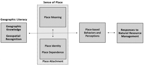
Geographic literacy illustrates the importance of place names, which denote place-based meaning and reflect shared or competing histories, politics, cultural narratives, and people-place relationships (Helleland Citation2012; Tucker and Rose-Redwood Citation2015). These same qualities are recognized as integral to peoples’ sense of place, which has been identified as a predictor of place-based, if not pro-environmental, attitudes and behaviors (Helleland Citation2012; Masterson et al. Citation2017; Trimbach, Fleming, and Biedenweg Citation2020). This understanding informs our conceptual framework (), which illustrates how geographic literacy informs and interacts with peoples’ sense of place, which in turn influences their place-based behaviors, perceptions, and responses to natural resource management. This framework builds upon those of interdisciplinary sense of place scholars, who have shown that sense of place, partly built upon place-based knowledge and recognition, informs or predicts place-based behaviors and perceptions, including responses to place-based conservation and place change more broadly (Masterson et al. Citation2017; Reilly, Adamowski, and John Citation2019; Trimbach, Fleming, and Biedenweg Citation2020). For example, Trimbach, Fleming, and Biedenweg (Citation2020) found that Puget Sound residents with a high or strong sense of place (e.g., place attachment) are more likely to frequently engage in pro-environmental stewardship activities. Similarly, Reilly, Adamowski, and John (Citation2019) found that New Brunswick residents’ place meanings informed their opposition to place change (e.g., infrastructure projects). In both cases, geographic knowledge or recognition plays a role, as does other factors stemming from people-place relationships. We apply this framework to consider implications of geographic literacy in the transboundary Salish Sea region.
Figure 1. Conceptual framework.
The Salish Sea Context
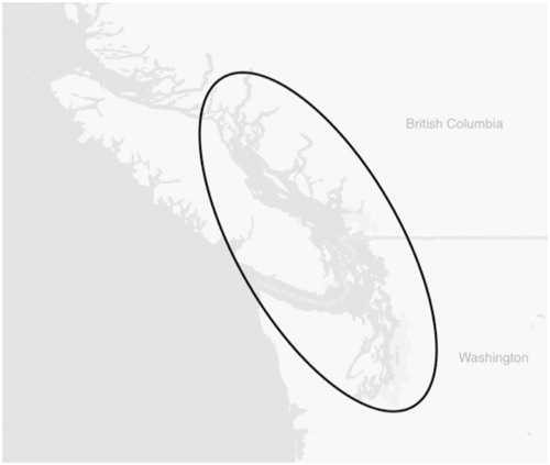
The Salish Sea is a transboundary inland sea ecosystem shared by British Columbia (BC), Canada, Washington (WA), United States, and numerous indigenous governments. Consisting of the Strait of Georgia, Strait of Juan de Fuca, and Puget Sound (), the sea encompasses 16,925 sq. km of marine waters and is rich in biodiversity (Gaydos and Pearson Citation2011). A component to helping the residents of this region think at the ecosystem-level, was the 2009-2010 adoption of the Salish Sea as the shared name for the sea. The adoption of the name was not an arbitrary or benign process, but rather intentional and directly linked to demonstrating that the waterbody is an integrated marine ecosystem. This renaming followed decades of campaigning, notably by Dr. Bert Webber from Western Washington University, who saw the need for a shared name to better illustrate how the Salish Sea is a transboundary integrated ecosystem and to better connect the public to the marine environment, as having a single shared place name could increase people’s awareness and connection to the waterbody (Mapes Citation2009; Tucker and Rose-Redwood Citation2015). Such sentiments are shared by toponymic or place name scholars, who note that shared place names connect thought, language, and the environment, and act as powerful symbols that render poignant connections, both physical and mental, and force people “to think with the landscape and not just about it,” (Thornton Citation1997, 132). The name reflects and honors the Coast Salish peoples who have been its stewards since time immemorial, but is not without controversy, as the renaming process itself has been subject to critique, given that the process perpetuated non-indigenous and settler colonial governments’ roles over place naming of indigenous lands and that indigenous place names were not fully considered (Murphyao and Black Citation2015; Tucker and Rose-Redwood Citation2015). Renaming was partly built upon the perceived environmental benefits of a shared place name and understanding of the place itself.
Figure 2. Survey question map.
We examine the geographic literacy of BC and WA residents with an emphasis on the Salish Sea. This study seeks to provide the wider environmental community with a base of knowledge of what people call and know about this waterbody. This study’s findings provide this knowledge and also illustrate the potential applications and benefits of geographic literacy to inform natural resource management.
Methods and Analysis
Between January and March 2019, we used Qualtrics (software) to survey adults residing in BC and WA. Respondents were drawn from an online opt-in panel of incentivized participants. We used stratified sampling to elicit equal representation across BC and WA and proportionate representation for age and sex. Stratified sampling was conducted to ensure greater generalizability between the sample and larger population. A sample size of 2,405 (actual n; goal n = 2,400) out of approximately 12.4 million residents (combined) was identified because the sample would have an estimated margin of error of ± 2% at the 95% confidence level.
The survey was developed to be short, concise, and replicable. Survey question construction mirrored those of similar geographic literacy studies (Roper Public Affairs Citation2006; Council on Foreign Relations and National Geographic Society Citation2016). The survey included four closed-ended questions (Questions 1–4) focused on geographic literacy and one open-ended question (Question 5) focused on place name meaning. The closed-ended question responses included commonly used place names used for the Salish Sea at common scales, including those other names used to describe the Salish Sea’s various waterways. The waterbody description responses included common body of water types and these options along with the place names were tested among a small sample of environmental planners (n = 15) with experience communicating about the Puget Sound or Salish Sea both from WA and BC to ensure these responses would likely register among transboundary residents.
Closed-ended questions and their respective responses included: (1) Which of the following names best describes the body of water located between Olympia, Washington in the south to Campbell River (on Vancouver Island), British Columbia in the north, and west to Neah Bay (on the Olympic Peninsula) and includes the large cities of Seattle and Vancouver to the east?, Response options: Pacific Ocean, Puget Sound, Salish Sea, Strait of Georgia, Strait of Juan de Fuca, and I don’t know; (2) Which of the following descriptions best defines the body of water outlined in the previous question (Question 1)?, Response options: A large artificial reservoir, A large freshwater lake, A large inland saltwater sea, The ocean, and I don’t know; (3) Identify the outlined body of water on the map ()?, Response options: Pacific Ocean, Puget Sound, Salish Sea, Strait of Georgia, Strait of Juan de Fuca, and I don’t know; and (4) Prior to this survey, had you ever heard of the Salish Sea?, Response options: Yes, No, and I don’t know. The open-ended question (5) elicited what the Salish Sea meant to respondents in order to gauge place meaning. Respondents’ education, years of residence, ethnic or cultural origins (BC), ethnicity and race (WA), regional district (BC), and county (WA) were also elicited.
We conducted our analysis with Statistical Package for Social Sciences (IBM SPSS Statistics 24). For the closed-ended questions, Pearson’s chi-square (χ2) along with Cramer’s V were conducted to test for significant associations between demographic factors and responses (Field Citation2013). As this study emphasized geographic differences, country of residence was the primary demographic factor; however, other demographic factors were also analyzed. Multinomial logistic regression (MLR) (Field Citation2013) was also conducted to illustrate whether or not place of residence (WA, BC) was a significant predictor of responses. MLR is understood to be a helpful approach for modeling when dependent factors are discrete sets of one or more choices or options (Hyun and Ditton 2006; Field Citation2013). MLR was conducted for each closed-ended question and the model included the following demographic factors: place of residence (WA, BC), sex (Female, Male, Other), age (16 age groups), education level (12 education groups), and length of residence (4 residency length groups); however, for the purpose of this project place of residence (WA, BC) was emphasized. This additional MLR analysis thus provides an additional analysis largely unseen within geographic literacy research. We also identified the top five most frequently used words expressed in the final open-ended question using NVivo qualitative software. Through NVivo, we determined the most frequently used words by participants, removed stop words, like articles (e.g., the and an), and included similar stemmed words in the query (e.g., talk and talking). By including stemmed words, like water and waters or tribal and tribe, the query could reduce potential meaning duplications.
Results
2,405 (n) respondents who resided in BC (50%) and WA (50%) participated. Respondents’ sex and age mirrored those of the general population, with similar percentages of men (49%) and women (51%) participating and ranging from 18 to 39 (37%), 40–59 (38%), and 60 and older (25%). While numerous demographics were elicited, the study focuses on regional variations between BC and WA residents, as this data directly informs transboundary efforts.
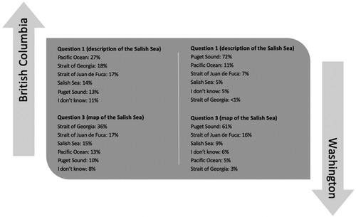
Residents were largely unfamiliar with the Salish Sea as a place name, with variations between BC and WA residents (Questions 1 and 3) (). BC residents had a mix of responses, while WA residents overwhelming selected Puget Sound (72%, 61%) (Question 1 and 3). Respondents also largely hadn’t heard of the Salish Sea before, with WA residents being less aware (62%, no) than BC residents (46%, no) (Question 4). Respondents were asked to characterize this geographic area based on a list of waterbody type responses. WA residents largely selected saltwater sea (59%), while BC residents mostly selected the ocean (62%) in comparison (Question 2). The five most frequently used meaning words included: water (22.95%), body (as in water body) (17%), sea (14.38%), nothing (12.88%), and Salish (9.10%) (Question 5). The majority of these meaning words relate to water or a physical attribute, or what Williams (Citation2014) notes are inherent place meanings, while the fourth illustrates that the name is so unfamiliar that it lacks meaning among some respondents.
Figure 3. Geographic literacy question responses.
What exactly lies behind these response patterns? Place of residence was the most prominent demographic associated with responses, although all other demographics had associations. For example, we found a significant (χ2) and strong (V) association between place of residence (BC or WA) and responses to the written description of the Salish Sea question, χ2 (5, n = 2,405) = 907.69, p < .001, V .61 (Question 1). This significant (χ2) and strong (V) association between place of residence and responses was also found for the cartographic representation of the Salish Sea question, χ2 (5, n = 2,405) = 863.84, p < .001, V .60 (Question 3). These two associations illustrate that BC and WA residents use different place names or have different geographic knowledge of the Salish Sea.
Place of residence also featured prominently as a demographic predictor of responses as illustrated by MLR. Place of residence was the most consistent factor that predicted responses, including the only demographic factor to the waterbody characteristics question (e.g., saltwater sea) (Question 2). For example, place of residence, specifically residing in WA, significantly predicted whether or not respondents selected Puget Sound or Salish Sea when responding to the written description of the Salish Sea question (Question 1). Similar significant patterns were observed with all question responses and place of residence, illustrating the powerful role of place of residence, place rootedness, or place-dependence on geographic literacy. While place of residence was the most prominent predictor, other demographics also informed response patterns to a more limited degree and with some variations depending on the question. For example, sex significantly predicted responses to the map question (Question 3) and only place of residence significantly predicted responses to the waterbody description question (Question 2).
Conclusion and Discussion
Our findings indicate that geographic literacy, specifically of the Salish Sea, is low and lacking among residents in the Salish Sea region. For example, WA residents overwhelming imagine and refer to the area as Puget Sound, while BC residents, while more aware of the Salish Sea name, have more variation in place names. This lack of awareness likely reflects the newness of the place name, strong attachments to or familiarity with alternative place names, localisms, and inconsistencies and variations in how the Salish Sea is represented to the public. While this pattern may seem somewhat obvious given the recent name change, it is not uncommon to have geographic illiteracy and variations thereof around old place names and geographic areas or their attributes (Roper Public Affairs Citation2006; Council on Foreign Relations and National Geographic Society Citation2016). For example, if different government agencies, media entities, educational institutions, or environmental organizations use inconsistent and unstandardized names, like Puget Sound or Strait of Georgia, this can hinder wider familiarity and adoption of the Salish Sea.
Framing the Salish Sea as an integrated ecosystem and inland sea for conservation or management is partly prefaced on a shared place name that evokes a shared place, identity, and responsibility; however, this does not seem to be the case. This lack or low geographic literacy may equate to a lack of understanding of how or why decisions and actions at one place or scale within the larger system can ripple throughout the region. For example, that a regulatory decision on fishing by BC’s provincial government in Victoria can impact the Puyallup Tribe near Tacoma, WA. A low or lack of geographic literacy and place name familiarity impacts and complicates place meanings, place identities, and overall senses of place. As stated by Cheng, Kruger, and Daniels (Citation2003) “natural resource management actions create, transform, and destroy place meanings—meanings around which individuals and groups develop a sense of identity, (98).” Thus, managers should be more aware of the potential use or influence of geographic literacy, including knowledge, use, or meanings of place names, within their work, as they likely impact peoples’ responses to and engagement in such efforts.
Recognizing that passive aspirations for regional recognition and use of the name Salish Sea has not been successful over the last decade, The SeaDoc Society has embarked on a campaign to raise awareness of the term Salish Sea throughout the region. This campaign called “Know the Salish Sea,” seeks to increase awareness of and connection to the Salish Sea. This campaign aims to enhance residents’ knowledge and familiarity with the Salish Sea, and also inculcate a shared sense of place and responsibility. This aligns well with how geographic literacy informs sense of place and ultimately our responses to wicked problems and place change. Geographic literacy, as outlined in the conceptual model and this brief case study illustrates how this construct can be adopted and tested to inform collective natural resource management efforts. Thus, as the transboundary population becomes more geographically literate, then natural resource or conservation efforts may acquire a more well-aligned public, that in turn may make such efforts more wider reaching and productive.
Acknowledgments
The authors acknowledge the indigenous peoples who have lived along and stewarded the shared inland sea now formally called the Salish Sea since time immemorial. The authors would also like to acknowledge Dr. Sharmodeep Bhattacharyya at Oregon State University for their statistical guidance.
Additional information
Funding
References
- Cheng, A. S., L. E. Kruger, and S. E. Daniels. 2003. Place as an integrating concept in natural resource politics: Propositions for a social science research agenda. Society & Natural Resources 16 (2):87–104. doi:10.1080/08941920309199.
- Council on Foreign Relations and National Geographic Society. 2016. What college-aged students know about the world: A survey on global literacy. New York: Council on Foreign Relations.
- Gaydos, J. K., and S. F. Pearson. 2011. Birds and mammals that depend on the salish sea: A compilation. Northwestern Naturalist 92 (2):79–94. doi:10.1898/10-04.1.
- Helleland, B. 2012. Place names and identities. Oslo Studies in Language 4 (2):95–116. doi:10.5617/osla.313.
- Hyun, W.-Y., and R. B. Ditton. 2006. Using multinomial logistic regression analysis to understand anglers willingness to substitute other fishing locations. In Proceedings of the 2006 Northeastern Recreation Research Symposium. NRS-P-14: 248–255.
- Field, A. 2013. Discovering statistics using IBM SPSS statistics. Los Angeles: SAGE.
- Mapes, L. V. 2009. State board adds Salish Sea to region’s watery lexicon. The Seattle Times, 31 October.
- Masterson, V. A., R. C. Stedman, J. Enqvist, M. Tengo, M. Giusti, D. Wahl, and U. Svedin. 2017. The contribution of sense of place to social-ecological systems research: A review and research agenda. Ecology and Society 22 (1):49. doi:10.5751/ES-08872-220149.
- Murphyao, A., and K. Black. 2015. Unsettling settler belonging: (Re)naming and territory making in the Pacific Northwest. American Review of Canadian Studies 45 (3):315–31. doi:10.1080/02722011.2015.1063523.
- Reilly, K. H., J. F. Adamowski, and K. John. 2019. The role of place meanings in opposition to water-related infrastructure projects: The case of the Mactaquac Dam, New Brunswick. Ecology and Society 24 (4):34–54. doi:10.5751/ES-10811-240434.
- Roper Public Affairs. 2006. National geographic-roper public affairs: 2006 Geographic Literacy Study. New York: GfK NOP.
- Thornton, T. F. 1997. Anthropological studies of native American Place names. American Indian Quarterly 21 (2):209–28. doi:10.2307/1185645.
- Trimbach, D. J., W. Fleming, and K. Biedenweg. 2020. Whose Puget sound?: Examining place attachment, residency, and stewardship in the puget sound region. Geographical Review. doi:10.1080/00167428.2020.1798763.
- Tucker, B., and R. Rose-Redwood. 2015. Decolonizing the map? Toponymic politics and the rescaling of the Salish Sea. The Canadian Geographer/Le Géographe canadien 59 (2):194–206. doi:10.1111/cag.12140.
- Turner, S., and J. Leydon. 2012. Improving geographic literacy among first-year undergraduate students: Testing effectiveness of online quizzes. Journal of Geography 111 (2):54–66. doi:10.1080/00221341.2011.583263.
- Williams, D. R., W. P. Stewart, and L. E. Kruger. 2013. The emergence of place-based conservation. In Place-based conservation: Perspectives from the social sciences, ed. W. P. Stewart, D. R. Williams, and L. E. Kruger, 1–17. Dordrecht, Netherlands: Springer.
- Williams, D. R. 2014. Making sense of ‘place’: Reflections on pluralism and positionality in place research. Landscape and Urban Planning 131:74–82. doi:10.1016/j.landurbplan.2014.08.002.