Abstract
Soil erosion by water is currently one of the most notable types of land degradation in Samanalawewa Watershed in Sri Lanka, creating copious environmental and socioeconomic impacts. Thus, with the aim of detecting and mapping the rates of human-induced soil erosion in the watershed, remote sensing and geographic information system based modelling and field experiments were carried out. The results of the assessment disclosed that the present rate of human-induced soil erosion varies from 0 to 289 t ha−1 yr−1 with the majority of the area exceeding the natural rate of soil erosion by 14 to 33 times at present. However, the average rate of human-induced soil erosion has declined dramatically from 19.8 to 4.3 t ha−1 yr−1 from 1986 to 2008. In order to analyse the significant determinants of farm-level adoption of soil and water conservation measures, binary logistic regression procedure was applied using the data collected through a household survey (n = 201). The most significant (p<0.01) variables of the study were the farmers’ perceptions of soil erosion problems, gender of the household head, training on soil and water conservation, and ascertained advice from agricultural extension officers while the variables regarding past awareness about soil conservation technologies and off-farm income were significant at p<0.05. Furthermore, the study revealed that the majority (60.2%) of the farmers in the study area had been adopting different types of soil and water conservation measures for a prolonged period of time. Therefore, owing to the current decreasing rate of soil erosion, the soil and water conservation costs and the ratios of human-induced soil erosion vs natural soil erosion had declined significantly while the productivity of their lands had gone up.
Introduction
Soil erosion is a complex process that involves the detachment, movement and deposition of soil particles influenced by both wind and water (Lal Citation2001, Sui et al. Citation2009). Soil erosion by water is the most crucial land degradation problem worldwide. Its associated negative impacts include decline in soil productivity, increased risk of flash flooding and increased siltation in reservoirs (Eswaran et al. Citation2001). Moreover, the sediments and attached pollutants such as nutrients, pesticides and toxic materials can also negatively affect water quality, aquatic habitats and hydrological systems (Zhang et al. Citation2009).
In Sri Lanka, soil erosion has drawn widespread attention since the 1990s, and it has been generally recognized as the most serious environmental problem especially in the upper watershed areas of the central mountain region of the country (Stocking Citation1992, Gunatilake and Gopalakrishnan Citation1999, Hewawasam Citation2010). Past studies on land degradation in Sri Lanka had in fact indicated the magnitude of degradation problems in different agro-ecological regions of the country (Chisholm et al. Citation1999). For example, after conducting soil profile analysis, Coomaraswamy et al. (Citation1999) found that the up-country tea plantation areas have totally lost their topsoil horizons. The best available estimates suggested that as much as 30 cm of topsoil has been lost from upland areas over the last century, which is equivalent to an average loss of 40 t ha−1 yr−1. As to the effect of land degradation on the country's yield of rubber, Samarappulli et al. (Citation1999) observed that the magnitude is high in areas with rubber plantations, even though rubber is a closed canopy crop. Furthermore, the land degradation problem is even more severe in non-plantation agro-ecosystems than in areas used for crop plantations (Zijlstra Citation1989, Stocking Citation1992). According to Somaratne et al. (Citation1997), the estimated aggregate annual average cost of soil erosion in Sri Lanka in terms of nutrient replacement cost is 86.3 million United States dollars (US$) per year, which highlights the severity of soil erosion in the country.
The study area could be considered as a particularly crucial watershed in Sri Lanka as it hosts one of the most important hydropower generating reservoirs of the country, the ‘Samanalawewa Reservoir’. This reservoir, which harnesses the waters of the Walawe River, was formed by damming the river at the confluence of the Belihul Oya (a tributary) and the Walawe River at an elevation of 400 m above mean sea level (MSL). Most of the paddy farmers in the downstream area depend solely on the diverted waters of the reservoir for irrigation (TEAMS Citation1992). In spite of a substantial change in land use that occurred in the watershed as in many other watersheds, no soil erosion-related studies had been conducted in this area since 1986 (Udayakumara et al.Citation2010). As a result, there is a dearth of baseline information on soil erosion, which comes as a hindrance for monitoring the extent of soil erosion in the watershed and in mitigating its effects. Nevertheless, it had been noted that from the number of studies on soil erosion and soil and water conservation (SWC) measures that were carried out in the other watersheds in Sri Lanka, only few studies tried to examine the factors encouraging the adoption of SWC measures and assessing their impacts.
Thus, this study was aimed at assessing the current status of soil erosion, specifically human-induced, and analysing the farm-level adoption of SWC measures and their impacts.
Materials and methods
Study area
The study area is situated in the Ratnapura District of Sri Lanka, which stretches from the north at 80.58° to 80.92° longitude to the east at 6.56° to 6.80° latitude, and covers an area of about 536 km2 ().
Figure 1. Location map of the study area.
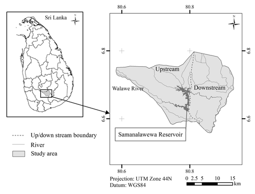
The upper part of the watershed lies along the southern face of the rise to Horton Plains and Peak Wilderness in the Nuwara-Eliya Divisional Secretariat Division (DSD) of the Nuwara-Eliya District, while the lower part, inclusive of the Samanalawewa Hydro Electric Reservoir (897 ha) which is the major water body of the watershed, lies within the DSD of Imbulpe and Balangoda. The Hydro Power Station situated in the DSD of Weligepola supplies about 10% of the country's hydroelectricity requirements (Laksiri et al. Citation2005).
The study area belongs to three climatic zones, namely the Wet, Dry and Intermediate. The upper catchment is in the Wet zone, while the dam and the Samanalawewa reservoir are located in the Intermediate zone. A bimodal pattern of rainfall is characteristic of the Intermediate zone unlike in the Wet and the Dry zones where the rainfall has a dominantly seasonal character. In the Wet zone much of the rainfall is received during the southwest monsoonal period (May to September) and in the Dry zone during the northeast monsoonal period (November to February). The Intermediate zone shows rainfall peaks in April (average 292 mm) and November (336 mm). Rainfall data for the period from 1922 to 2008 shows that this zone has an annual average rainfall of 2247.7 mm. The mean annual temperature of the study area varies from 25 to 28 °C (UdayakumaraCitation2011). Geologically the region consists of rocks belonging to the Highland group which comprises quartzites, marbles and undifferentiated metasediments. The latter comprises garnet, granulites, charnockites and biotic gneisses of Precambrian age. The dominant rock type of the region is granulites followed by charnockites. The study area consists of six major soil groups such as Red Yellow Podzolic soils (RYP), Reddish Brown Earths (RBE), Immature Brown Loams (IBL), Low Humic Gley soils (LHG), Regosols (RG) and Alluvial soils. The distribution of the above soil types within the study area show that the upper catchment is basically covered by RYP soils and RG. RYP soils, IBL soils and Alluvial soils are characteristic of the lower catchment and the reservoir area. In addition to the RYP soils, IBL soils and Alluvial soils the water table drain-down area and the areas downstream also contain RBE soils and LHG soils (TEAMS Citation1992). However, the study area comprises six major soil types, with the RYP soils the dominant soil type in the study area, covering approximately more than 75% of the area (DISL Citation1998). The soil is low erodible inherently because of its high infiltration capacity. However, it can cap and compact, leading to impermeable layers that are subjected to high rates of sheet erosion as seen in degraded tea estates (Stocking Citation1992) and when they occur on steep slopes exposed to heavy rainfall (TEAMS Citation1992).
Population and income
The population in the watershed is not evenly distributed because of its terrain and land-use pattern (TEAMS Citation1992). The current population of the study area is 86,954 and the mean incomes of the households (HHs) in the upstream and downstream areas, and in the watershed were 235, 269 and 244 US$ per month, respectively (Udayakumara Citation2011).
Household size
In the upstream and downstream areas combined, more than 84% of the HHs had fewer than or equal to 5 family members. Specifically in the upstream area, 56.3% of the HHs had 4 or 5 family members (belonging to the medium category), 34.4% had fewer than 4 members (small category), and 9.3% had more than 5 members (large category). For the downstream area, 52.0% of the HHs fall in the medium category, while 32.0% are in the small and 16.0% are in the large categories. On average, the household (HH) size in the downstream area is 4.3 members compared with 4.1 family members in the upstream area (Udayakumara Citation2011).
Occupational structure
In general, agriculture is the predominant occupation in the study area, where irrigated paddy (Oryza sativa) is the major crop in the downstream area while in the upstream area diverse types of crops are grown with tea (Camellia sinensis) and irrigated paddy as the major crops followed by some vegetables such as tomato (Solanum lycopersicum) and beans (Phaseolus spp.). About 44.5% of the total population are engaged in agriculture, 26.9% in off-farm employment, 10.0% in wage labour and another 10% are students, and 8.6% are in other occupations such as running small-scale enterprises, trading, among others (Udayakumara Citation2011).
Types of land-use
Although data on land use in the study area have not been updated since 1992, the available information based on past land use classification, indicated six major categories, namely: intensive agriculture (28.3%), forest plantations (5.3%), natural forests (26.0%), grass lands (29.9%), built-up areas (7.8%) and the remaining 2.7% comprised water bodies (TEAMS Citation1992).
Data used
The data were collected from various sources that came in digital and analogue formats as well as from field experiments, and from the results of the HH questionnaire survey. The basic data used in the study included:
| • | Remote sensing (RS) data: used two ALOS satellite images – (sensor: AVNIR-2, resolution: 12 m spatial, acquisition date: 25 February 2008). | ||||
| • | Digital elevation (1:10,000) data: taken from the Department of Survey, Sri Lanka. | ||||
| • | Findings from field experiments to determine the minimum and the maximum soil erosion rates (mm yr−1) at 30° slope (methodology is given below). | ||||
| • | Results from HH questionnaire survey data (methodology is given below). | ||||
| • | Tabular data: taken from the Divisional Secretariat Divisions (DSDs) and the Department of Census and Statistics of Sri Lanka, and various other reference materials. | ||||
Assessment of human-induced soil erosion
Due to the paucity of available data, the soil erosion model shown in Equation (Equation1) (Honda 1993) was used to assess the annual rate of soil erosion in the study area. This model had also been previously used in other studies that deal with climatic and geomorphological conditions which were similar with those in the study area, especially those conducted in the Ashio region of Japan (Honda Citation1993), in Siwaliks watershed of Nepal (Honda et al. Citation1996) and in the northern region of Thailand (Hazarika and Honda Citation2001). Since the model is less data intensive, it is applicable in the Samanalawewa Watershed as it fulfils the requirements that could give satisfactory results. The model is mainly influenced by slope gradient, vegetation index, and maximum and minimum rates of soil erosion at 30° slope in the study area. Thus, the annual rate of soil erosion (E) could be defined as:
Since Equation (Equation2) cannot be directly applied to the study area, field methods for assessing land degradation (Stocking and Murnaghan Citation2001) were applied to estimate the minimum and maximum soil erosion rates which were necessary as inputs for the model. Since RYP soils are the dominant soil type in the study area (DISL Citation1998), it was assumed that sheet erosion is most common. Twelve experimental plots (12×12 m×12 m) with 144 (12×12) artificially simulated pedestalsFootnote1 were established in the study area in 2008 to measure the maximum and minimum soil erosion rates (mm yr−1) on 30° slopes. Selection of the plot sites was made in such a way that major soil types are represented as well as land cover types where the minimum and maximum erosion occurs are included. In the study area, forest cover is associated with minimum and bare land with maximum erosion. Consequently, six experimental plots were established on bare land for the maximum erosion measurements, and six experimental plots under dense forest cover for the minimum erosion measurements. The average bulk density of soils in the study area was measured using the core sampler method.
After one year, the height of each pedestal was carefully measured and taken the average heights for the experimental plots established on bare lands for maximum erosion, and also plots under dense forest cover for minimum erosion. The difference between the height of the pedestal and the surrounding soil surface represents the soil loss. Therefore, by knowing the timing of the disturbance, it is possible to estimate a rate of soil loss (mm yr−1).
Due to its protective function, vegetation cover could be used as an important indicator of land degradation by soil erosion (Rubio and Bochet Citation1998). Besides protecting the soil surface, vegetation is also an important factor that influences the physical condition of soils (Shrestha and Kingshuk Citation2008). The indicator value of vegetation is expressed in various forms, one of which is the NDVI, as defined in Equation (Equation3). The NDVI was used to assess the vegetation cover in the study area. To avoid negative values and for easy handling of digital data, NDVI obtained for the ALOS were rescaled using Equation (Equation4).
Assessment of farm-level adoption of SWC measures
Adoption could be defined in various ways and there are also a number of methods for evaluating adoption. In general, adoption can be defined as the extent to which a new technology is utilized and balanced with other activities by a user over a long period of time, assuming that the user has full information on the technology as well as its potential benefits (Featherstone et al. Citation1997). This section discusses the methodology for assessing the farm-level adoption of SWC practices. The analysis, which made use of the data mostly from the results of the HH survey, was carried out using the SPSSTM 16.0 software.
Sampling procedure
The study area consisted of 23,304 HHs from 67 upstream villages and 4638 HHs from 9 downstream villages (DCSSL Citation2007), of which 15 upstream villages and 6 downstream villages were randomly selected for the study. The selected 21 villages had a total of 7269 HHs (N). Using Equation (Equation5), the sample size (n) was calculated (Yamane Citation1967), and the considered sample size (n) and sample fraction (k) were 201and 0.027, respectively. Thus, for the HH survey, from the upstream and the downstream villages 151 and 50 HHs (n = 201) were selected respectively based on proportionate sampling. Most of the time questionnaires were completed by conducting interviews with randomly selected HH heads with an age of 28 to 72 years old. However, on a few occasions we were unable to meet the HH heads; on such occasions the next most experienced person was interviewed. In general, the questionnaire was designed to document the farmer's perception of soil erosion problems, educational level of the HH head, age of the HH head, family size, gender of the HH head, past awareness about SWC measures, security of tenure, size of lands under crop, off-farm income, dependency ratio, size of rented lands, training in SWC, membership in SWC committees, advice from extension officers and assistance in SWC practices, information on adopted SWC measures and their effectiveness. In addition to above-mentioned socioeconomic information, we took representative GPS locations of each surveyed HH farmlands in order to correlate modelled soil erosion values with farmers’ socioeconomic characters. In most cases, an interview lasted between 1.5 and 2 hours, during the period of 16 February to 15 April 2009. The questionnaire survey was conducted by a researcher with the help of six trained enumerators.
Variables specification and working hypotheses
In this study, a dichotomous dependent variable (Y) was defined which signifies whether or not a HH is willing to adopt the SWC measures, and where Y=1 if a HH is willing to adopt the SWC measures, and Y=0 otherwise. The selected independent variables of the study were hypothesized to be associated with the willingness to adopt the SWC measures. Considering the author's knowledge of the conservation systems in the study area, the findings from past studies and questionnaire surveys, and the existing theories, 15 explanatory variables were selected to structure the working hypotheses. The potential explanatory variables, which were hypothesized to have influenced the farmers’ willingness to adopt the SWC measures in the study area, are briefly described below.
X1. Farmer's perception of soil erosion problems
This is a dummy variable, which measures the farmers’ awareness of the soil erosion problems. If a HH head has encountered soil erosion problems, the variable would take the value 1 and 0 otherwise. Thus, this variable is expected to be also positively associated with the farmers’ willingness to adopt the SWC measures.
X2. Educational level of HH head
As a dummy variable, if a HH head is literate (attended primary education, secondary education or tertiary education),Footnote2 it takes the value 1 and 0 otherwise. Therefore, this variable was hypothesized to have a positive role in the decision-making process for adopting the SWC measures.
X3. Age of HH head
This is a continuous variable to determine the age of the HH head in years. The farmer's age can be considered as a composite of the effect of farming experience and planning horizon. While longer experience has a positive effect, young farmers on the other hand may have a longer planning horizon and hence may be more likely to invest in conservation activities (Asrat et al. Citation2004). Featherstone and Goodwin (Citation1993) disclosed that an older farmer who is looking at a shorter time horizon, might not be able to get back all of the benefits from any conservation investment. Therefore, in this study it was hypothesized that age has a negative influence on the adoption of SWC measures.
X4. Family size
This refers to the total number of family members in a HH, which is a discrete variable. As soil conservation activities are more labour intensive, HH with large human resources may invest more in such conservation activities. Thus, family size was hypothesized to have a positive influence in the adoption of the SWC measures.
X5. Gender of HH head
This is a dummy variable, which takes the value 1 if the HH head is male and 0 otherwise. In general, male heads of HH tend to participate more in soil conservation activities than the female heads. Thus, in this study it was hypothesized that the gender of the HH head had positive influence in the adoption of the SWC measures.
X6. Past awareness about SWC measures
This is a dummy variable, which assesses the farmers’ past awareness about the SWC measures. It takes the value of 1 if the HH has taken part in SWC activities in the past and 0 otherwise. Thus, knowledge of SWC in the past was hypothesized to have a positive influence in the adoption of the SWC measures.
X7. Security of tenure
This is a dummy variable, which measures the farmers’ property rights. Security of tenure takes the value 1 and an ambiguous property rights the value 0. In this study, security of land tenure was hypothesized to have a positive influence in the adoption of the SWC measures.
X8. Size of land under crop
This is a continuous variable, which denotes the total area of crop land (ha) owned by sample respondents at the time of the survey. Farm size is often correlated with the wealth that could help ease the needed liquidity constraints (Asrat et al. Citation2004). Some studies have disclosed that large farms are more likely to use conservation measures than small farms (Norris and Batie Citation1987, Bekele and Drake Citation2003).Thus, the size of crop land was considered to be positively related with the adoption of the SWC measures.
X9. Off-farm income
This is a continuous variable, which estimates the amount of off-farm income in Sri Lankan Rupees that the sampled HH could earn in a year. However, the direction of influence of this variable on the adoption of soil conservation measures is indeterminate (Mbaga-Semgalawe and Folmer Citation2000). On one hand, this variable is expected to have a positive influence on the assumption that diversification of agricultural practices (investment in off-farm activities) would enable HHs to earn income thereby easing the liquidity constraint needed for soil conservation investments. On the other hand, if farming is not the main income-earning activity, off-farm income earners may decide not to invest their financial resources in soil conservation activities. Empirical studies however, have reported both positive and negative relationships between off-farm income and adoption of the SWC measures (Asrat et al. Citation2004).
X10. Dependency ratio
This is a ratio of the number of children 14 years of age or younger, disabled family members, and the elderly 65 years of age or older, to the number of economically active members aged from 15 to 64 years of age (CBSL Citation2007). This variable is expected to have a negative effect on farmer's willingness to adopt soil conservation measures.
X11. Size of rented lands in hectares
As a continuous variable, this takes into consideration the general practice of landlords paying for the expenses related to soil conservation activities. As the percentage of land of a farmer increases, it is less likely that he or she will provide funds for conservation expenditures (Featherstone and Goodwin Citation1993). Thus, the expected effect of this variable on farmer's willingness to adopt SWC measures was considered negative.
X12. Training on SWC
This is a dummy variable, and a result of gaining knowledge on SWC measures, consequences of better farm production (Illukpitiya and Gopalakrishnan Citation2004). Therefore, this variable had been hypothesized to have a positive relationship with the adoption of soil conservation measures. Hence, if a farmer has gained knowledge from SWC training, the variable takes the value 1 and 0 otherwise.
X13. Membership in SWC committees
This is a dummy variable, which leads to a significant positive impact if farmers serve in SWC committees on soil conservation. Hence, if a farmer is a member of such a committee, the value is 1 and 0 otherwise.
X14. Advice from extension officers
This is a discrete variable and dependent on how many times a farmer receives advice from extension officers per year. As noted, there is a significant impact on farmers who frequently receive advice from extension officers in mitigating soil erosion. Therefore, it was hypothesized that extension services have a positive relationship with the adoption of the SWC measures.
X15. Assistance in soil conservation practice
This is a dummy variable, which implies any support in terms of materials, fertilizers, financial and other incentives provided to the farmers to encourage them to adopt the SWC measures. Hence, if the farmer had already been given such support, the variable takes the value of 1 and 0 otherwise.
The above selected variables and the hypothesized directions of their influence are summarized in .
Table I. Hypothesized determinants for the adoption of SWC measures.
Model specification
Binary logistic regression procedure is a popular statistical method (Hair et al. Citation1998) wherein the probability of a dichotomous result (such as adoption or non-adoption) is related to a set of explanatory variables that are hypothesized to influence the result. In this study, the logistic model characterizing the adoption of SWC measures by the sample HH is specified in the following Equation (Equation6).
Where: i=i th observation in the sample
P i =probability of the outcome
β 0 =intercept
β 1, β 2,…, β k =coefficients associated with each explanatory variable X 1, X 2…., X k
From the selected 15 independent variables, eight were categorical, five continuous and two were discrete variables. At the start, the above-mentioned 15 covariates were used for the bivariate correlation analysis. Then the correlated (p<0.05) variables (13) were used for the forward binary logistic regression analysis in order to eliminate the insignificant (p>0.05) variables and for further selection of the most important variables that influenced the decision to adopt the SWC measures in a binary logistic regression model.
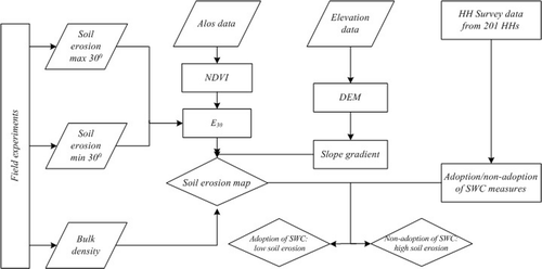
The stepwise research procedure for assessment of soil erosion, farm-level adoption of SWC measures and their correlation is shown in . First, the E 30 erosion values of each pixel were calculated using Equation (Equation2), after which the soil erosion from each pixel with different slopes was calculated using Equation (Equation1). Then, a raster map of slope gradients was prepared with a pixel size of 12 m (the same as those of the ALOS data) using a Digital Elevation Model (DEM) in order to obtain the slope information necessary for Equation Equation1. The NDVI values were then calculated using the ERDASTM 9.1 software and all overlay analyses were carried out in geographic information system (GIS) environment using the ArcGISTM 9.2 software. Thus, the annual soil erosion rates were determined while a soil erosion map was produced. To examine the relationship between modelled soil erosion with SWC characteristics of surveyed HHs, we also collected GPS locations of farmland of HHs being interviewed during the field work. This was overlaid with a soil erosion map to find out the computed soil erosion rate at respective locations. We hypothesized that farmers who adopted SWC activities for long periods are having low soil erosion, and have less expenditure towards SWC measures.
Figure 2. Schematic representation of the research procedure of the assessment of soil erosion and farm-level adoption of SWC measures.
Results and discussion
Human-induced soil erosion is a growing concern in most areas of Sri Lanka. Thus, this study was performed with a view to assessing the current rate of human-induced soil erosion, analysing the farm-level adoption of SWC practices, and to find a relationship between modelled soil erosion with SWC characteristics of surveyed HHs in the Samanalawewa watershed.
Human-induced soil erosion
In 2008, the average maximum and minimum rates of soil erosion collected at 30° slopes from the field plots (using the artificially created pedestals) in the study area were found to be 21.50 mm yr−1 and 0.10 mm yr−1, respectively. Moreover, the maximum, minimum and mean NDVI values computed from the ALOS images were +0.600, –0.633 and +0.239 (s.d.=0.16), respectively, while the average bulk density of the soils of the study area was 1.31 g cm-3. Finally, the study calculated the soil erosion at the pixel level () and the maximum, minimum and mean annual soil erosion rates obtained were 22.1 mm yr−1, 0.0 mm yr−1 and 0.33 mm yr−1 (s.d.= 0.31), respectively.
Figure 3. Soil erosion map of the study area.
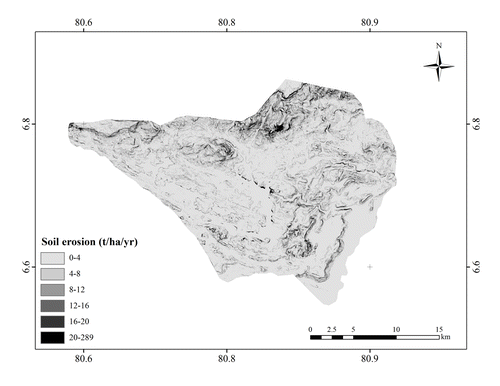
Based on the results of the study, six preliminary categories of soil erosion ranging from very low to extremely high were identified ().
Table II. Status of soil erosion in Samanalawewa Watershed, 2008.
Furthermore in 2008, the gross rate of soil erosion in the study area ranged from 0.0 to 289.0 t ha−1 yr−1 with an average of 4.3 t ha−1 yr−1 (s.d.=4.1). According to TEAMS (Citation1992), the Department of Irrigation of Sri Lanka carried out a sediment sampling study in the study area during the period from October 1985 to September 1986, and reported that the average rate of erosion was 19.8 t ha−1 yr−1. Considering the result of the soil erosion study conducted by the Department of Irrigation in 1986, the present average rate of soil loss has declined from 19.8 to 4.3 t ha−1 yr−1 between 1986 and 2008. This could be due to the fact that farmers living in the hilly areas of the watershed have planted vegetative propagated tea on still existing bare lands as a major source of livelihood since the late 1980s because tea has since that time become a highly lucrative plantation crop in Sri Lanka. Moreover, the farmers had been compelled to manage their tea lands properly by applying adequate soil conservation measures and fertilizers provided by the government at a concession rate.
Field methods have been developed to measure the natural rates of soil formation at the soil–bedrock interface by several studies (Heimsath et al. Citation1997). However, such rates of soil formation have not been measured in any region of Sri Lanka. Hence direct comparison of soil loss with experimentally derived soil formation rate poses a big challenge at this level. Alternatively, Hewawasam et al. (Citation2003) have found that the natural rates of erosion ranged from 0.13 to 0.30 t ha−1 yr−1 in the Upper Mahaweli watershed in Sri Lanka, using the cosmogenic nuclide method. Based on the finding of Hewawasam et al. (Citation2003), the current rate of human-induced soil erosion in the study area is about 14 to 33 times higher than the natural rate of soil erosion. Furthermore, the current gross rate of erosion in the watershed is 4.3 t ha−1 yr−1 (s.d.=4.1), although in some areas, the rate of human-induced soil erosion could be as high as 289 t ha−1 yr−1 mainly due to human-induced forest fires, wanton destruction of forests and switching from cultivation of the existing paddy to soil erosion-inducing cash crops such as tomato, cabbage (Brassica oleracea) and beans. From an environmental conservation point of view, these results can be taken as baseline information for formulating soil conservation programmes and policies.
Adoption of SWC at farm level
The results of the survey have indicated that out of the 201 surveyed HHs, 60.2% were willing to adopt the SWC measures and 39.8% not willing.
The HH survey further found that an average age of the HH head was 54.3 years in the study area. However, an average age of the HH head is 55.5 years of farmers in the SWC adopted category compared with the average age of 58.3 years farmers in the SWC non-adopted category indicating that the SWC non-adopted category farmers are bit older than the SWC adopted farmers. An average HH size of 5 members in the adopted category compared with HH size of about 4 family members in the non-adopted category indicating that adopted category is densely populated than the non-adopted category. An average land under crop had an equal value (1.78 ha) for both categories. However, an average off-farm income is 22 times higher than the adopted category farmers compared to non-adopted category farmers. If a person has greater wealth, he is less likely to make risk-averse decisions. Further, when a farmer has other sources of income (other than farming), one might expect him to invest more in SWC practices (Illukpitiya and Gopalakrishnan Citation2004). Thus, the off-farm income is positively related to investment decision on SWC. Average dependency ratio of the study area is 0.41. However, this value (0.37) is a bit lower in adopted farmers compared with non-adopted farmers’ value (0.47). Since most of the farmers in the study area have their own farm lands, average size of the rented lands in both categories is much less (<0.4 ha/HH). Land tenure is an important determinant of investment decisions on SWC. Land tenure, coupled with the ambiguous land property rights between collectives and individuals encourage short-sighted decisions and the irresponsible use of land resources (Hu Citation1997). Farmers who cultivate land owned by others may be less likely to invest in SWC. This may be due to the perceived insecurity of the tenancy. Hence, tenant might find it profitable to prepare and use the land for growing crops since he is not sure of receiving the benefits of SWC. Tenants lose part of their income as rent for the land, which acts as a financial obstacle to SWC. On the other hand, landowners may not be willing to pay for SWC on the lands rented out because they feel that part of the on-farm benefits of SWC would go to the tenants (Illukpitiya and Gopalakrishnan Citation2004). Thus, the land-tenure status is positively related to decision-making in SWC (Ervin Citation1986). The HH survey found that accessibility to the extension officer/s area is also having a smaller value (4/yr) for the both categories ().
Table III. Summary of sample respondents and variables used in the regression model.
Furthermore, farmers’ perception of soil erosion problems, educational level of the HH head (> grade 5), gender of the HH head (male), past awareness about SWC measures, security of tenure, training on SWC, membership in SWC committees and assistance in SWC practice are 63.7%, 64.2%, 65.7%, 61.2%, 68.7%, 59.7%,71.6% and 70.5% respectively (). In general, these personal characteristics, viz. perception of soil erosion problems, educational level, gender, past awareness about SWC measures, training on SWC, membership in SWC committees and assistance in SWC practices indicated a strong positive relationship with investment decision on soil conservation. Formal education may be an effective variable to capture environmental awareness of farmers who are basically literate. Experience helps farmers to gain knowledge on the benefits of conservation through learning by doing (Illukpitiya and Gopalakrishnan Citation2004).
Moreover, out of the 13 correlated variables, six variables were included in the binary logistic model. Four variables, namely: farmers’ perception of soil erosion problem, gender of HH head, training on SWC and advice received from the extension officers were significant at 0.01%. The other two variables such as past awareness about technology and off-farm income were found to be significant at 0.05% (). For testing the goodness of fit of the model, we applied the Hosmer–Lemeshow test (Dobson and Barnett Citation2008) since we have categorical as well as continuous predictors in the model. Hence, according to the Hosmer–Lemeshow test we can conclude that model fits the data well (p=0.871).
Table IV. Parameter estimates of the variables included in the binary-logistic model.
X1. Farmers’ perception of soil erosion problems
The farmers’ perception of a soil erosion problem was found to have positive and significant effect on the adoption of the SWC measures. When the farmer has a perception of the soil erosion problem, the odds of adaptation to SWC measures is 2403 times the odds with the farmer who has no perception of any soil erosion problem after controlling for other factors.
X5. Gender of HH head
The gender of the HH head had positive and significant effect on the adoption. The results showed that if a HH head is male, the odds of adaptation to SWC measures increase by a factor of 2844 after controlling for other factors.
X6. Past awareness about SWC technologies
Past awareness about SWC technologies had positive and significant effect on the adoption. The results indicated that a farmer who had been aware in the past about soil conservation technologies increases the odds of adaptation to SWC measures by a factor of 54 times the odds with a farmer who had no idea about the soil conservation technologies after adjusting for other factors.
X9. Off-farm income
Off-farm income had a positive and significant effect on the adoption of the SWC measures. However, the results of this study revealed that a farmer who has off-farm income is equally likely to adopt SWC measures compared with a farmer who has no off-farm income.
X12. Training on SWC
Training on SWC has a positive and significant effect on the adoption of the SWC measures. The results indicated that a farmer who has undergone training on SWC and the odds of adaptation to SWC measures increase by a factor of 523 than a farmer who has not joined any training on SWC after adjusting for other factors.
X14. Advice from extension officers
Advice from the extension officers has positive and significant effects on the adoption in the model. The results explained that for a farmer who has received advice from extension officers, the odds of adaptation to SWC measures is 6 times the odds of a farmer who has not taken any advice on soil conservation from extension officers after adjusting for other factors.
Correlation between modelled soil erosion with SWC characteristics of surveyed HHs
Based on the results of the HH survey, it was revealed that 60.2% of the farmers have been adopting the SWC measures such as agronomic practices (e.g. the use of mulch and organic manure, and soil surface/subsurface treatments), vegetative measures (e.g. increasing trees, shrub and grass cover), structural measures (e.g. constructing terraces, bunds and ditches), and improved management (e.g. changing species composition of crops, controlling cropping intensity and observing fallow period). Of these SWC adopted farmers, 48.2% respondents perceived that structural measures are the most popular conservation measures adopted to deal with soil erosion, followed by agronomic (31.6%) and vegetative measures (19.5%). The least widely used measures are management measures as indicated by only 0.7% respondents.
Moreover, the results also indicated that 19.8% of the farmers have been adopting SWC measures for more than 20 years, with 12.4% farmers adopting the measures for 15 to 20 years, 24.8% for 10 to 15 years, 18.2% for 5 to 10 years and another 24.8% for less than 5 years ().
Table V. Impacts of adoption of SWC measures for soil erosion in Samanalawewa Watershed.
Finally, this research was able to find out the proper correlation between modelled soil erosion values with surveyed HHs’ SWC characteristics as we hypothesized in our methodology. Since the farmers in the study area have been adopting the SWC measures, the average SWC costs, average rate of soil erosion and the ratios of human-induced soil erosion vs natural soil erosion have drastically declined. shows that the farmers who have adopted the SWC measures for more than 20 years incurred the least conservation cost (30.8 US$ ha yr−1) as well as the least soil erosion rate (1.8 t ha−1 yr−1) compared with the farmers who have adopted SWC measures only recently (less than 5 years).
Finally, from this study the following conclusions and recommendations could be synthesized. The assessment of soil erosion in the study area revealed that the current rate of human-induced soil erosion ranges from 0 to 289 t ha−1 yr−1 with the majority of the area exceeding the natural rate of soil erosion especially in the up-county areas of Sri Lanka. The results disclosed further that the average human-induced soil loss rate has been declining from 19.8 to 4.3 t ha−1 yr−1 from 1986 to 2008 mainly due to the farm-level adoption of SWC measures. However, the existing rate of human-induced soil erosion is still within the range of 14 to 33 times higher than the natural rate of soil erosion. The impacts of the farmers’ perception of soil erosion problems, gender of HH head, training on SWC measures and advice received from the agricultural extension officers, on the farm-level adoption of SWC measures were positive and highly significant (p<0.01) with decision on adoption of SWC measures, while past awareness about the soil conservation technologies and off-farm income were also positive but significant only at p<0.05. The majority of the farmers (60.2%) in the study area have been adopting SWC measures for different time periods. In view of the farmers’ decision to adopt the SWC measures, the farmers’ present average cost of SWC and average rates of soil erosion have declined significantly. Consequently, the productivity of their lands has also been significantly increased. Based on this study, a number of key management issues can be identified in relation to SWC in Samanalawewa Watershed area. In the study area, human-induced soil erosion can be further diminished by providing framers with strong motivation for SWC. Obtaining farmer adoption of SWC practices will require the use of various implementation tools such as education, technical assistance and subsidies. Teaching and extension efforts may need to be specifically designed to reach these farmers to further improve their understanding of the soil erosion problem and get adapted to proper SWC measures on their farmlands. In this analysis, off-farm income also indicated a significant positive effect on adoption of SWC measures, but the importance of social factors cannot be neglected as the analysis also showed a significant group effect among personal factors. A successful soil conservation policy in Sri Lanka will require careful planning and coordination of SWC measures with inputs of physical and financial resources. There is an urgent need for strong public and private partnership to combat soil erosion in the Samanalawewa Watershed of Sri Lanka. Hence, these results should be carefully considered when designing and implementing soil conservation policies and programmes in the future.
Acknowledgements
The authors wish to thank three anonymous reviewers and the editor-in-chief for their constructive comments and suggestions in revising the original version of this paper.
Notes
1. A pedestal is a column of soil standing out from the general eroded surface, protected by a cap of resistant material (such as a stone or root). Pedestals can be artificially simulated by using bottle tops pressed into the soil (Stocking and Murnaghan Citation2001).
2. Note: Primary education is equivalent to attending Grades 1–5, secondary education is equivalent to Grades 6–12 and tertiary education implies obtaining a Certificate, Diploma, Bachelor's degree, Master's degree, Master's of Philosophy degree and Doctorate (CBSL Citation2007).
References
- Asrat , P. , Belay , K. and Hamito , D. 2004 . Determinants of farmers’ willingness to pay for soil conservation practices in the south-eastern highlands of Ethiopia . Land Degradation and Development , 15 : 423 – 438 .
- Bekele , W. and Drake , L. 2003 . Soil and water conservation decision behaviour of subsistence farming in the Eastern Highlands of the Ethiopia: a case study of the Hunde-Lafto area . Ecological Economics , 46 : 437 – 451 .
- [CBSL] Central Bank of Sri Lanka 2007 . Annual Report, Central Bank of Sri Lanka . Available at: http://www.cbsl.gov.lk/ (Accessed 23 December 2008).
- Chisholm , A. , Ekanayake , A. and Jayasuriya , S. K. 1999 . Economic policy reforms and the environment: Land degradation in Sri Lanka , Australia : Ministry of Public Administration, Home Affairs, Plantation Industries and Parliamentary Affairs of Sri Lanka and School of Business, La Trobe University .
- Coomaraswamy , A. , Ekanayake , A. , Chisholm , A. and Jayasuriya , S. K. 1999 . “ Effect of land degradation on tea productivity ” . In Economic policy reforms and the environment: Land degradation in Sri Lanka , Edited by: Chisholm , A. , Ekanayake , A. and Jayasuriya , S. K. Ministry of Public Administration, Home Affairs, Plantation Industries and Parliamentary Affairs of Sri Lanka and School of Business, La Trobe University, Australia .
- [DCSSL] Department of Census and Statistics Sri Lanka 2007 . Handbook of Census and Statistics . Department of Census and Statistics, P.O. Box 563, Colombo 07.
- [DISL] Department of Irrigation Sri Lanka 1998 . Soil Map of Sri Lanka . Land Use Division, Ministry of Lands and Land Development, Rajamalwatte Road, Battaramulla .
- Dobson , A. J. and Barnett , A. G. 2008 . An introduction to generalized linear models , 3rd Edn , Boca Raton : Chapman and Hall/CRC .
- Ervin , D.E. 1986 . “ Constraints to practicing soil conservation: land tenure relationships ” . In Conserving soil: Insights from socioeconomic research , Edited by: Lovejoy , S. B. and Napier , T. L. Ankeny , IA : Soil Conservation Society of America .
- Eswaran , H. , Lal , R. , & Reich , P. F. 2001 . Land degradation: an overview . In Responses to land degradation , 2ndInternational Conference on Land Degradation and Desertification . Thailand , 25 – 29 January, 1999 .
- Featherstone , A. M. and Goodwin , B. K. 1993 . Factors influencing a farmer's decision to invest in long-term conservation improvements . Land Economics , 69 : 67 – 81 .
- Featherstone , A. M. , Kaliba , A. R. M. and Norman , D. W. 1997 . A stall-feeding management for improved cattle in semiarid central Tanzania: factors influencing adoption . Agric. Econ , 17 : 133 – 146 .
- Gunatilake , H. M. and Gopalakrishnan , C. 1999 . The economics of reservoir sedimentation. A case study of Mahaweli reservoirs in Sri Lanka . Water Resources Development , 15 : 511 – 526 .
- Hair , J. F. , Anderson , R. E. , Tatham , R. L. and Black , W. C. 1998 . Multivariate Data Analysis , Upper Saddle River : Prentice-Hall .
- Hazarika , M. K. and Honda , K. 2001 . “ Estimation of soil erosion using remote sensing and GIS. Its valuation and economic implication on agriculture ” . In Sustaining the Global Farm , Edited by: Stott , D. E. , Mohtar , R. H. and Steinhardt , G. C. West Lafayette : Purdue University and USDA-ARS National Soil Erosion Laboratory .
- Heimsath , A. M. , Dietrich , W. E. , Nishiizumi , K. and Finkel , R C. 1997 . The soil production function and landscape equilibrium . Nature , 388 : 358 – 361 .
- Hewawasam , T. 2010 . Effect of land use in the upper Mahaweli catchment area on erosion, landslides and siltation in hydropower reservoirs of Sri Lanka . Journal of the National Science Foundation of Sri Lanka , 38 : 3 – 14 .
- Hewawasam , T. , Blanckenburg , F. , Schaller , M. and Kubik , P. 2003 . Increase of human over natural erosion rates in tropical highlands constrained by cosmogenic nuclides . Geology , 31 : 597 – 600 .
- Honda , K. 1993 . Evaluation of vegetation change in the Asio copper mine using remote sensing and its application to forest conservation works , Japan : D. Eng. dissertation, University of Tokyo .
- Honda , K. , Samarakoon , L. , Ishibashi , A. , Mabuchi , Y. , & Miyajima , S. 1996 . Remote sensing and GIS technologies for denudation estimation in a Siwalik watershed of Nepal . International Seminar on Water Induced Disaster (ISWID) , Nepal , 26 – 29 November, 1996 .
- Hu , W. 1997 . Household land tenure reform in China: its impact on farming land use and agro environment . Land Use Policy , 14 : 175 – 186 .
- Illukpitiya , P. and Gopalakrishnan , C. 2004 . Decision-making in soil conservation: application of behavioral model to potato farmers in Sri Lanka . Land Use Policy , 21 : 321 – 331 .
- Laksiri , K. , Gunathilake , J. & Iwao , Y. 2005 . A case study of the Samanalawewa Reservoir on the Walawe River in an area of karst in Sri Lanka . Multidisciplinary Conference, San Antonio Texas 24 – 28 September 2005 .
- Lal , R. 2001 . Soil degradation by erosion . Land Degradation and Development , 12 : 519 – 539 .
- Mbaga-Semgalawe , Z. and Folmer , H. 2000 . Household adoption behavior of improved soil conservation: the case of North Pare and West Usambara Mountains of Tanzania . Land Use Policy , 17 : 321 – 336 .
- Norris , P. E. and Batie , S. S. 1987 . Virginia farmers soil conservation decision: an application of Tobit analysis . Southern Journal of Agricultural Economics , 19 : 79 – 90 .
- Rubio , J. L. and Bochet , E. 1998 . Desertification indicators as diagnosis criteria for desertification risk assessment in Europe . Journal of Arid Environment , 39 : 113 – 120 .
- Samarappulli , I. N. , Ekanyake , A. , Samarappuli , L. and Yogaratnam , N. 1999 . “ Modeling the effect of land degradation on yield of rubber ” . In Economic Policy Reforms and the Environment: Land Degradation in Sri Lanka , Edited by: Chisholm , A. , Ekanayake , A. and Jayasuriya , S. K. Australia : Ministry of Public Administration, Home Affairs, Plantation Industries and Parliamentary Affairs of Sri Lanka and School of Business, La Trobe University .
- Shrestha , R. P. and Kingshuk , R. 2008 . Land degradation assessment in the Greater Mekong Sub-region . Journal of Environmental Information Science , 36 : 29 – 38 .
- Somaratne , W. G. , Chisholm , A. , Jayasuriya , S. , & Bandara , J. S. 1997 . Impact of trade liberalization in non-plantation agriculture in Sri Lanka on economic growth and environmental degradation: a computable general equilibrium (CGE) analysis . 41st Annual Conference of Australian Agricultural and Resource Economics Society (AARES) , Gold Coast , Australia , 20 – 25 January 1997 .
- Stocking , M. A. 1992 . Soil erosion in the upper Mahaweli catchment , Environment and Forest Conservation Division, Mahaweli Authority of Sri Lanka, Polgolla .
- Stocking , M. A. and Murnaghan , N. 2001 . Hand book for the field assessment of land degradation , London : Earthscan .
- Sui , J. , He , Y. and Liu , C. 2009 . Changes in sediment transport in the Kuye River in the Loess Plateau in China . International Journal of Sediment Research , 24 : 201 – 213 .
- [TEAMS] Technology Evaluation and Management Services 1992 . Samanalawewa hydro electric project, environmental post evaluation study. Draft final report . Colombo , , Sri Lanka : TEAMS.
- Udayakumara , E.P.N. 2011 . Land degradation and rural livelihood in the Samanalawewa catchment, Sri Lanka . PhD Dissertation, Asian Institute of Technology, P.O. Box 4, Klong Luang, Pathumthani 12120, Thailand.
- Udayakumara , E. P. N. , Shrestha , R. P. , Samarakoon , L. and Schmidt-Vogt , D. 2010 . People's perception and socioeconomic determinants of soil erosion: a case study of Samanalawewa watershed, Sri Lanka . International Journal of Sediment Research , 25 : 1 – 18 .
- Yamane , T. 1967 . Statistics: An introductory analysis , New York : Harper and Row .
- Zhang , Y. , Degroote , J. , Wolter , C. and Sugumaran , R. 2009 . Integration of Modified Universal Soil Loss Equation (MUSLE) into a GIS framework to assess soil erosion risk . Land Degradation and Development , 20 : 84 – 91 .
- Zijlstra , P. J. 1989 . Erosion hazard and land suitability in the Nuwara Eliya , Nuwara Eliya , , Sri Lanka : IRDP Project .