Abstract
In Tigray, Ethiopia, land degradation is a dominant environmental problem and hence the regional government has undertaken restoration measures on degraded soils since 1991. The present study was aimed to assess the impact of land uses and soil management practices on soil properties, and consequently on soil quality of degraded soils. The catchments selected were Maileba and Gum Selassa, and land uses included cultivated (CL), grazing (GL), plantation (PA) and area exclosure (AE). Replicated soil samples were collected from topsoil and profiles of four land-use types in both catchments. Soils in area exclosure showed higher soil organic carbon (SOC), total N and extractable K than grazing land, cultivated land and plantation area mainly at 0–40 cm soil depth. Estimated soil organic carbon stock at Maileba in 0–40 cm depth varied between 54 to 74 Mg C ha−1, being lowest in cultivated land and highest in area exclosure, and the soil organic carbon stock in area exclosure represents 63% of total carbon stock stored in the profile. Soil organic carbon stock (0–40 cm) at Gum Selassa ranged between 33 to 38 Mg C ha−1, being higher in cultivated land and lower in plantation area. Soil quality index (SQI) of area exclosure (0.794) at Maileba and cultivated land (0.721) at Gum Selassa scored highest among all land uses, and the order was area exclosure>grazing land>plantation area>cultivated land at Maileba and cultivated land>grazing land>plantation area at Gum Selassa, highlighting the effectiveness of area exclosure in restoring soil quality of degraded soils.
Introduction
The long history and recent intensification of agriculture in Ethiopia has led to soil degradation through land-use changes (Kebrom and Hedlund Citation2000, Gete and Hurni, Citation2001, Woldeamlak Citation2002) and the subsequent soil quality deterioration (Mulugeta et al. Citation2004, Citation2005a). Many studies in Ethiopia (Woldeamlak and Stroosnijder Citation2003, Mulugeta and Itanna Citation2004, Mulugeta et al. Citation2005a) and elsewhere (Guo and Gifford Citation2002, Shrestha et al. Citation2004, Awasthi et al. Citation2005) have reported that conversion of forest land into arable land with the aim of expanding cultivated land has caused land degradation and often result in accelerating soil erosion (Warkentin Citation1995), nutrient depletion (Gong et al. Citation2006), soil organic matter (SOM) reduction (Mulugeta et al. Citation2005b) and soil quality degradation (Solomon et al. Citation2000). Deforestation results in historical significant loss of both soil organic carbon (SOC) and inorganic carbon (SIC) worldwide (Lal Citation2002) and the impact is more pronounced on the topsoil (Sombroek et al. Citation1993). As a result, SOC vary considerably both along with land-use types and soil depths. But apart from land use, the level of SOC is also determined by many factors such as climatic factors (e.g. temperature and moisture regime) and edaphic factors (e.g. parent materials, soil drainage, texture etc.). The SOC accumulation is higher, for example, on higher altitude due to low degrees of decomposition associated with low temperature and high rainfall (Lal Citation2008).
Land use and management affects the SOC and nutrient in the soil. Restoration and management of degraded land with various conservation measures or disturbing virgin lands may significantly contribute to enhance or degrade soil quality (Lal Citation2002, Singh and Lal Citation2005). Doran and Parkin (Citation1994) define soil quality as the ‘capacity of a soil to function, within ecosystems boundaries, to sustain biological productivity, improve environmental quality and support human and plant health’. Soil quality cannot be measured directly but inferred indirectly by measuring soil physical and chemical properties which serve as quality indicators (Diack and Stott Citation2001). However, soil properties do have different degrees of influence on soil quality. As a result an assessment of integrated soil quality index (SQI) on the basis of the weighted contribution of each soil property may serve better in quantifying soil quality indicator for different land uses (Diack and Stott Citation2001, Awasthi et al. Citation2005).
The state of Tigray is characterized by high environmental degradation induced by improper use of land resources that has occurred for many decades (e.g. Dereje et al. Citation2002, Mekuria et al. Citation2007). To address these problems various environmental rehabilitation programmes that include plantations of exotic and indigenous species, and introducing area exclosure (i.e. closing area to allow natural regeneration of forest without the interference of animals and humans) have been implemented on degraded lands (Descheemaeker et al. Citation2006a, Citation2006b, Mekuria et al. Citation2007). However, little is known about the impact of these land uses and management situations on carbon and nutrient status in the study area. Therefore, the increasing human disturbance and past deforestation on one hand and the restoration measures underway on the other hand makes Tigray state a typical and interesting area for integrated assessment of soil properties and soil quality changes in relation to land use and soil management. However, such studies are rare in Ethiopia in general and that of Tigray in particular where the level of land alteration is supposedly huge and land degradation is severe. Therefore the objectives of the present study were to: (1) quantify the amount and distribution of soil C stocks and major nutrients on soil surface and profile of different land uses and (2) determine soil quality indices for different land uses and soil management based on some selected soil properties.
Materials and methods
Study area
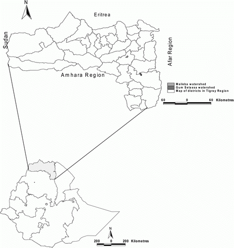
The study areas, Gum Selassa and Maileba, are located respectively at Hintalo Wajerat and Hagre Selam district of Tigray region. Gum Selassa catchment is located at 13°15′N and 39°32′E. It has a surface area of 23.5 km2 that lies on elevation ranges of 2100–2160 m a.s.l. Similarly Maileba catchment lies at 13°14′N and 39°15′E. The catchment has an area of 17.3 km2 and elevation varies between 2300 to 2830 m a.s.l. Location of the study area is given in .
Figure 1. Location of the study area.
Both study areas have annual precipitation of 400–700 mm, and mean daily maximum and minimum temperatures that vary between 20–30 °C and 8–15 °C, respectively. In both sites rainfall mainly occurs between June–September and temperature gets lower in September–November. Despite some micro-climate variation, no significant climate difference exists between these two sites that could importantly bring variation in soil properties alone. The dominant lithology of both study areas are composed of largely Agulae shale, Antalo limestone, dolerite and basalt. Silicified lacustrine deposit layers locally occur in between basalt layers at Maileba as well. Van de Wauw et al. (Citation2008) studied soil-landscape relations for the Maileba catchment.
Dominant soils at Gum Selassa area are Cambisols, Leptosols, Vertisols, Luvisols and Calcisol developed from shale and limestone. At Maileba major soils include Vertisols, Cambisols, Regosols and Fluvisols.
Vegetation cover is low in both areas and largely it remains only in small protected areas. Natural vegetation inside the area exclosures is dominated by Acacia etbaica and Euclea schimperi. Eucalyptus camaldulens is the major species on plantation sites, but other tree species such as Schinus molle also exist to some extent. Understorey vegetation in area exclosure and plantation area contains diverse species of grasses (e.g. Chloris gayana Kunth, Pennisetum petiplare (Hochst) Chiov, Cymbopogon caesius, Cynodon dactylon) and shrubs (e.g. Acokanthera schimperi, Lantana viburnoides, Calpurnia aurea, Maytenus arbutifolia). Most of the understorey vegetation is palatable for livestock and hence serves as sources of feed for livestock through the cut-and-carry system, although sometimes there is also illegal grazing inside these protected areas.
Soil sampling and laboratory analysis
Selected sites for this research contain four dominant land-use types consisting of cultivated land (CL), grazing land (GL), plantation area (PA) and area exclosure (AE) at Maileba and three land-use types at Gum Selassa (all with the exception of area exclosure). At both sites land uses exist close to each other. Our intention in this research was to study the variation in soil nutrient content and soil quality with respect to differences in land-use types and hence land use was the main factor considered.
From each land use, replicated soil samples were collected from both catchments in 2007. The first batches of samples were collected from surface soils (0–20 cm) using auger replicated three to five times. A total of 25 soil samples were analysed for organic carbon (OC), total N, available P (Pav), available K (Kav), sand, silt and clay for assessing the general properties of each land use in each catchment. The second batches of samples were collected from profiles dug to a depth of 80 cm. In each land-use type three to five randomly chosen profiles were dug and samples collected from 0–20, 20–40, 40–60 and 60–80 cm depths. The numbers of profiles were 3, 5, 4 and 3 in AE, CL, GL and PA, respectively at Maileba, and 4, 3 and 3 in CL, GL and PA, respectively at Gum Selassa. Hard rock was found in some of the profile after 40 cm as a result all profiles did not have the same depth. A total of 94 samples were collected and analysed for OC, total N, Pav and Kav. Simultaneously, soil samples for determining bulk density (BD) were also collected using core samplers with a volume of 100 cm3 from each depth of the profiles as well as from the surface soils.
The soils collected from the field were air dried, lightly ground and passed through a 2-mm sieve prior to physicochemical analysis. Textural analysis was performed using Boycous hydrometer method after the organic matter was removed by hydrogen peroxide (H2O2) and the soil was dispersed by sodium hexametaphosphate (Na6P6O18). Walkley–Black oxidation method for SOC and digital pH meter for pH were used for their determination. Olsen method (Olsen and Sommers Citation1982) for Pav, flame photometer (Black et al. Citation1965) for Kav, and Kjeldahl method (Bremner and Mulvaney Citation1982) for total N were used for soil analysis. Bulk density was determined after core samples were dried in an oven at 105 °C for 24 hours. Percentage of pore space (soil porosity) was computed from bulk density result and a particle density of 2.65 Mg m−3 as suggested for mineral soil (Brady Citation2002).
Calculation of carbon stocks
Soil carbon stock (g C m−2) for each sample depth was computed using the following equation
Where d=soil layer thickness (cm); BD=bulk density (g cm−3) of each sample depth, OC=carbon concentration (g kg−1) of each soil sample, CFst (%)=correction factor for fraction of fragments>2 mm and the multiplication factor 10 is a value obtained when units of all variables are multiplied. It results in carbon stock in g C m−2×10.
Carbon stock for each layer of the dominant land use was calculated by multiplying the C stock obtained by equation Equation1 by the total area covered by a particular land use. Subsequently, C stock in each soil layer thickness was summed up to determine total C stock contained up to 80 cm depth for each land-use type. Finally, total C at a watershed level (Mg) was obtained as a summation of C up to 80-cm depth obtained from all land-use types assuming that the mean values of the parameters involved in the calculation of carbon stock from different land uses represent the entire catchment. Difference in soil bulk density caused due to difference in land use or cover affects the calculation of carbon stock by influencing the amount of soil sampled from the same soil depth (Solomon et al. Citation2002). Such differences in bulk density should be adjusted, particularly if the variation among the different land uses or covers is statistically significant. In the present study the variation was not significant among all land uses and even on those land uses that showed significant difference, the p value is marginal. Hence the influence was small and no correction measure was taken for bulk density.
Selection of indicators and minimum data sets
Selection of minimum data sets (MDS) of indicators was based on expert opinion by weighting according to the relative importance of each function in maintaining sustainable crop production in the study area. Minimum dataset for SQI consists of pH, BD, C, N, C/N, P and K, and these indicators were also suggested by others (e.g. Doran and Parkin Citation1996, Andrews et al. Citation2002, Awasthi et al. Citation2005, Tiwari et al. Citation2006).
Calculation of soil quality index
Soil quality index (SQI) reflects the relative quality of soils available under different land-use types. It is a useful tool to assess sustainability of soil resources that are managed and used in different land-use systems. However, different nutrients do have different roles in maintaining soil quality and as such SQI was calculated by selected soil factor memberships and their weights following a procedure similar to that of Tiwari et al. (Citation2006), Awasthi et al. (Citation2005) and Fu et al. (Citation2004).
Where n=number of observations, Wi=the weight vector of ith soil quality factor and Q(Xi)=membership value of each soil quality factor. The values Q(Xi) were calculated by ascending or descending functions using the equations given below, respectively.
Where Xij is the value of the soil physical and chemical properties that were selected for the soil quality. Xmax and Xmin are the maximum and minimum value of ith soil property. Based on appropriate ranges for individual soil properties favourable for plant growth and results of our laboratory analysis, two classes of functions were identified: (1) ‘More is better’ and (2) ‘Less is better’. Accordingly, we have chosen ‘More is better’ for C, N, C/N, P and K, and values were arranged in ascending order to compute Q(Xi) with equation Equation3. While for pH and BD, ‘Lower is better’ was chosen and values were arranged in descending order to compute Q(Xi) using equation Equation4.
The membership values, obtained using equation Equation3 and Equation4, of the selected soil quality factor were subjected to principal component analysis (PCA) to determine the weights for each soil indicator (Fu et al. Citation2004, Awasthi et al. Citation2005, Tiwari et al. Citation2006).
Where Ci is the component capacity score coefficient of soil quality factor i, obtained and calculated from PCA. Finally SQI was calculated as a summed product of membership values Q(Xi) and the weights of the selected soil quality indicators. To evaluate soil quality (i.e. improvement or deterioration) under the different land-use types, SQI was classified into five arbitrary classes as: (i) excellent (SQI>0.80), (ii) good (SQI=0.60–0.80), (iii) at risk (SQI=0.40–0.60), (iv), degraded (SQI=0.20–0.40) and (v) severely degraded (SQI<0.20) (Awasthi et al. Citation2005).
Statistical analysis
Analysis of variance (ANOVA) was made using general linear model procedure of Minitab statistical software to test the significant of mean difference on soil properties. Multiple mean comparison test was carried out to distinguish mean significant difference among treatments using Tukey test at a significance level of 5%.
Results
Surface soil properties under different land use types
In , mean values of soil properties of surface soil (0–20 cm) and their membership for different land-use types is given. Area exclosure at Maileba site gave higher values for most measured soil properties than the other land-use types involved in the same area. At Maileba, soils were higher in clay content, OC, Pav and Kav than at Gum Selassa, and the mean value for BD varied from 1.12 to 1.34 g cm−3, higher in grazing land (GL) and lower in area exclosure (AE). Also OC varied from 1.16 to 1.93%, total N from 0.11 to 0.20%, and available K from 169.6 to 460.3 mg kg−1 being highest in AE and lowest in cultivated land (CL) in all cases. However, at Gum Selassa the mean BD is higher in PA (1.33 g cm−3) and lower in CL (1.2 g cm−3). Similarly, available K was higher in plantation area (PA). Nevertheless, OC, total N and Pav was higher in CL and lower in PA.
Table I. Mean soil properties (0–20 cm), standard error of means (SEM) and membership values (Q(Xi) of different land uses. OC: Soil organic carbon; N: total nitrogen; C/N: carbon-nitrogen ratio; Pav: available phosphorus; Kav: available potassium; BD: Bulk density; n: number of samples; CL: cultivated land; GL: grazing land; PA: plantation area (Eucalyptus); AE: area exclosure.
SOC and major nutrient distribution under different land uses and soil depths
Both land uses (p=0.05) and soil depth (p=0.001) had a significant effect on BD. On the other hand, OC significantly varied with soil depth (p=0.007), but not with land-use types (). Yet, Pav and BD showed significant difference among land uses. However, the difference in Pav was significant only between cultivated and grazing lands (p=0.0034), and in BD between grazing land and area exclosure (p=0.0477) (). Depth-wise, OC differed significantly between 0–20 cm and 60–80 cm (p=0.0067). Also BD at 60–80 cm depth was significantly higher than in all soil layers above it. On the other hand, sites show significant difference for most measured soil properties (OC, total N, BD and C/N). On both sites, OC decreases with depth with a minor exception observed in CL at Maileba site, wherein an increase up to 60-cm depth was witnessed (). Among the land uses, OC distribution above 60-cm depth was highest in AE. At Gum Selassa, OC level is lower in PA followed by GL. In both sites BD varies between 1.1–1.7 g cm−3, being lower in the surface layer but tends to increase with depth across all land uses. Bulk density was lowest in AE and highest in GL. The ANOVA result also indicated significant difference between AE and GL. Bulk density significantly varies with depths as well. Eucalyptus-dominated plantations at Gum Selassa have low OC and higher BD than the same land use at Maileba likely because of degraded site condition prior to closing as well as low input from understorey and vegetation cover. This will have implications for the moisture retention and aeration of the soils for proper growth of life forms.
Table II. Result of general linear model analysis for major soil properties under four soil depths obtained from different land uses and two sites (p<0.05).
Table III. Results for Tukey paired wise multiple comparison test of soil properties for different land uses and soil depths (p<0.05).
Table IV. Depth- wise distribution of mean (± SEM) of soil properties under different land uses at Maileba and Gum Selassa sites.
Profile of SOC stocks
The soils under the different land-use types showed significant difference in SOC stocks at Maileba but not at Gum Selassa (). At Maileba mean SOC stock within 0–20 cm depth varied between 26 to 43 Mg C ha−1, significantly lower in cultivated land and higher in area exclosure (p<0.05). Soil organic carbon stock largely declined with depth at Maileba, particularly in area exclosure and plantation area. On the other hand, SOC stock was significantly higher in grazing land than in AE and PA at 60–80 and 40–60 cm soil depth respectively. But on both depths no significant difference in SOC stock was observed between grazing land and cultivated land-use types. At Gum Selassa no significant difference was observed among the different land-use types and depths. Between sites SOC stock did show variation and was generally higher at Maileba than at Gum Selassa.
Table V. Profile level carbon stocks at different land use types and two sites.
SQI for different land-use types
The Q(Xi) values for each indicator computed by equations Equation2 and Equation3 are shown in . The first component score gave a cumulative percentage of 72%, sufficient to explain soil quality variations among land uses and hence to compute Wi. The weight of the soil quality indicator reflects the relative importance of each indicator in explaining soil quality. As such OC at Maileba (Wi=0.172) and BD (Wi=0.168) at Gum Selassa showed higher scores. The first four indicators with highest weight scores according to their decreasing importance includes: OC, N, C/N, and K at Maileba, and BD, K, OC and P at Gum Selassa ((a) and (c)).
Figure 2. Weight for soil quality indicators (Wi) and soil quality index (SQI) for different land uses at Maileba (a and b) and at Gum Selassa (c and d), respectively. BD: bulk density; pH: soil pH; P: available P; K: available K; C/N: carbon-nitrogen ratio; N: total nitrogen, OC: soil organic carbon; CL: cultivated land; GL: grazing land; PA: plantation area (Eucalyptus); AE: area exclosure.
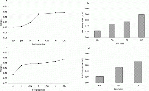
Result of the integrated SQI revealed that AE at Maileba (SQI=0.79) and CL (SQI=0.72) at Gum Selassa scored highest in their respective area ((b) and (d)). Grazing land scored intermediate but with relatively similar SQI value in both sites. According to the SQI classification, cultivated land (CL) at Maileba and plantation area (PA) at Gum Selassa falls into ‘degraded’ class, whereas plantation area at Maileba and grazing land (GL) at both sites fall into ‘at risk’ class. On the other hand, area exclosure (AE) at Maileba and cultivated land at Gum Selassa are of ‘good’ class.
Discussion
SOC and major nutrient distribution with depth under different land uses
Variation in SOC and nutrient distribution with depth are the result of interaction of complex processes such as land management, biological cycling, leaching, illuviation, soil erosion, weathering of minerals, atmospheric deposition, application of fertilizers and FYM.
In this study, the OC and major nutrients decreased with depth (with minor exceptions) but only showed significant difference in OC between the top (0–20 cm) and bottom (60–80 cm) soil depths (). Total N, OC and Kav distributions in 0–40 cm are higher in soils of area exclosures, although not statistically significant than the other land uses, mainly because of the restoration of natural vegetation and subsequent increase above and below ground biomass inputs. Area exclosures are often established on marginally degraded land where soil erosion has removed topsoil and provide little service to local community. Hence closing off the area from human and animal interference allows regeneration of natural vegetation and increase in vegetation composition (Dereje et al. Citation2002) and this in turn has increased litter fall (Descheemaeker et al. Citation2006a) leading to increased SOM in surface soil (Descheemaeker et al. Citation2006b, Mekuria et al. Citation2007). A study by Mekuria et al. (Citation2007) on a nearby area reported that soils of closed area had significantly higher SOM, total N, Pav exchangeable base and CEC than in open grazing land adjacent to it. The fact that PA and AE are often established on degraded soils makes the land-use types to have low SOC and major nutrients at a deeper profile. Contrary to this, soils of CL have more SOC at 40–60 cm depth at Maileba (). Translocation of SOC through the action of leaching or effect of deep-rooting crops may operate in these soils – a process responsible for accumulation of SOC in deeper depth. However, translocation of dissolved OC through the soil profile is more pronounced in areas with high precipitation whereas drier areas experienced less and have more accumulation in the upper 20 cm. In our case precipitation is somewhat higher at Maileba than Gum Selassa and this might have contributed to the transport and accumulation of OC in the lower part of the profile. A study by Mulugeta and Itanna (Citation2004) reported that in a drier climate in the Rift valley of Ethiopia, 50% of soil C is retained in the upper 20 cm of the soil while in humid and cool soils they found more even distribution across the profile. Increasing SOC, on the other hand, in the upper layer of cultivated lands are often associated with the agricultural practices such as tillage, FYM, fertilizer application and crop residue while in forest soils leaf litter and root litter inputs play a major role. Grazing modifies soil properties indirectly by influencing plant species composition (Burke Citation1999) mainly due to removal of above-ground biomass with subsequent effect on reducing litter addition to soils that are supposedly important for soil nutrient conservation and cycling (Solomon et al. Citation2000).
Reduction in SOM, total N and Pav was reported in free grazing land (Girma Citation1998, Mekuria et al. Citation2007). In this study no significant difference was observed in SOC, N and Kav among the different land-use types, but Pav showed significantly higher value (p=0.0034) in grazing land compared with cultivated land (). Other studies, however, found significantly higher SOC up to 60 cm in heavily grazed land compared with light or no grazing due to the addition of SOC through animal excrements (Franzluebbers et al. Citation2001). Hence, livestock can exert both beneficial and detrimental effects on a grazed field that can be explained in terms of improving or degrading soil nutrients depending on number of livestock and grazing intensity. In the present study, the fact that no significant difference exists in SOC among the different land-use types and that Pav is significantly higher on GL compared with CL indicates the significance of other inorganic sources of P such as weathering of P containing minerals. The higher Pav content in grazing land than CL, AE and PA also suggests that trees in closed and PA as well as crops in arable field may extract more Pav and immobilize a higher proportion of it as P pool on their biomass than grazing species do.
Profile of soil organic carbon stocks
Land use and associated soil managements are important variables that were hypothesized to bring difference in SOC stocks. The estimated SOC stock was higher in area exclosure (AE) and plantation area (PA) in the first two soil layers (0–40 cm) at Maileba compared with the lower depths. For example, AE and PA stored 63% and 67.9% of total SOC stock, respectively in the 0–40 cm depths. At Gum Selassa, soils at plantation area did not show the same trend. Dominant trees in the plantation are Eucalyptus species and there are varied opinions about their ecological effect. Soil organic carbon increases when Eucalyptus plantations are established on degraded soils whereas on newly cleared sites they have an adverse effect on soil quality (Zerfu Citation2002). Plantation at Gum Selassa did not show improvement in SOC stock when compared with grazing land (GL) and cultivated land (CL). The rate of C accumulation in soils and biota are determined among others by landscape position (Lal Citation2008, Nelson et al. Citation2008). As such PA is situated on a relatively steep area prone to high soil erosion that results in lower OC and higher BD. Carbon storage in forest soils is affected by forest type and soil quality. Also SOC accretion in mineral soils is age and tree species dependent (Lemma et al. Citation2006). Hence, the lower OC accumulation in plantation area at Gum Selassa is primarily related to poor soil quality prior to its establishment and the subsequent low litter input. The site was relatively degraded with areas with many visible outcrop rocks on the surface even at the present time. Being closer to a village there are also human and animal intrusions that severely damage the physical stand of trees as well as grass cover which might also contribute to lower SOM supply.
At Maileba, SOC stock is significantly lower in CL (26 Mg C ha−1) than in AE (43 Mg C ha−1), PA (36 Mg C ha−1) and GL (33 Mg C ha−1) at 0–20 cm depth, whereas at Gum Selassa no significant difference was observed (). Such difference between sites could be attributed to difference in landscape position, soil management, previous cropping history and local biophysical variation. Lower SOC at Maileba in CL reflects the severity of land degradation, whereas higher SOC stock in AE indicates the importance of such restoration measures in addressing SOC depletion in the area. Hence AEs are effective means of soil C sequestration in degraded area as shown by the increased C accumulation in the topsoil compared with the lower depths. For example, SOC in AE at 0–20 cm layer exceeds by 21, 12 and 12 Mg C ha−1 than in 60–80 cm, 40–60 cm and 20–40 cm depths, respectively.
Taking the entire 80 cm soil depth, the SOC stock varied from the minimum of 100 Mg C ha−1 under plantation area to the maximum of 133 Mg C ha−1 under grazing land at Maileba, and from the minimum of 68 Mg C ha−1 under grazing land to the maximum of 79 Mg C ha−1 under cultivated land at Gum Selassa. These estimates for all land uses and both sites are within a range of estimates (42.9–234.6 Mg C ha−1) found for Andosols, Nitosols and Solanchaks for 60 cm depth in southern Ethiopia (Mulugeta and Itanna Citation2004) as well as global average estimate for tropical Aridosols (42 Mg C ha−1), Ultisol (83 Mg C ha−1) and Oxisols (97 Mg C ha−1) for 100 cm soil depths reported by Kimble et al. (Citation1990). The higher mean SOC stock in grazing land compared with the other land uses at Maileba could be due to higher annual turnover of organic matter from dying grass roots despite heavy grazing. Grass roots decompose faster than tree roots and hence contribute higher organic matter to soils (Guo and Gifford Citation2002). Another possibility is the effect of animal excrement. But this was not reflected in the case of Gum Selassa.
At a catchment level, the dominant land uses involved in this study account for 77% and 95% of the total catchment area at Maileba and Gum Selassa, respectively. The total SOC stock stored (up to 80 cm) by all land-use types was estimated to be 159, 516 Mg C at Maileba and 172, 615 Mg C at Gum Selassa, of which 48% was found in 0–40 cm soil depth in both sites. The relative distribution of SOC between top layer soils and the layers below are comparable with results found in Bale Mountain, Ethiopia (Fantaw et al. Citation2006). The amount of SOC stock in the 0–40 cm soil depth for area exclosure and plantation area at Maileba account for 63–68% indicating the importance of topsoil layers of these land-use types acting as good sources of carbon sink but also the potential for large amount of CO2 emission upon conversion and mismanagement. Nevertheless, as these land uses cover a small part of the catchment (on both sites), their overall contribution on SOC stock at a catchment scale is very small (<5%). Cultivated lands and grazing land, on the other hand, constitute the largest area coverage in the catchments contributing to about 80% and 16% of SOC stock, respectively at Maileba, and 86% and 13% at Gum Selassa. These results demonstrate the need for policy priority and management systems focusing toward cultivated land and grazing land to ensure sustainable land management and enhance SOC sequestration in terrestrial ecosystems.
Soil Quality Index and land uses
Several researchers (e.g. Larson and Pierce Citation1994, Andrews et al. Citation2002) have pointed out that SOC is the most important indicator of soil quality because it determines many of the physical, chemical and biological soil properties (Wang et al. Citation2003). Similarly, BD influences agriculture by restricting air and water movement, and has been recognized as a key attribute of soil quality indicator (e.g. Andrews et al. Citation2002, Fu et al. Citation2004, Awasthi et al. Citation2005).
The calculated SQI varied between 0.27 to 0.79 at Maileba and 0.22 to 0.72 at Gum Selassa ((b) and (d)). Cultivated land at Maileba and plantation area at Gum Selassa scored least SQI and categorized into ‘degraded’ class suggesting that these land-use types are under threat and require immediate soil restoration and conservation measures for sustainable productivity. Conversely, higher SQI found in area exclosure at Maileba and in cultivated land at Gum Selassa highlights soils under these land-use types are better off regarding soil functioning and soil health (Andrews et al. Citation2003). These results demonstrate the extent to which soils under different land-use types differ in quality as influenced by level of input received from land use itself and from external sources such as fertilizer and manure inputs by human being. Also soils respond differently to management depending on inherent properties and the surrounding landscape. Given that area exclosures increase above- and below-ground biomass and that SOC and nutrients have improved, it is logical to assume higher SQI. However, higher SQI in cultivated land at Gum Selassa is something unexpected. Considering that soils under GL, CL and PA are situated under the same environment and climate conditions, we believe that the farmland has received fertilizer and manure prior to sampling and this has improved soil properties leading to higher SQI. Its relative location on a flat landscape might have also benefited CL to receive transported soils from upper areas. Measurement and inclusion of more physical, chemical and biological soil properties such as soil structure, infiltration, water-holding capacity, soil respiration, microbial biomass C and N, potentially mineralizable N and soil aggregate stability could improve the result of SQI.
This study showed how management choices affect soil quality. In Tigray despite the fact that the area covered with plantations, particularly with Eucalyptus trees, is expanding with the sole objective of improving degraded soils and increasing economic benefits, soils of both study sites were of poor quality. This suggests that either Eucalyptus trees were originally planted on degraded soils and as such could not restore fertility of the soil or the tree has an inherently degradative effect. In view of benefiting soil resources, this study demonstrates that Eucalyptus plantation is not a promising alternative and cannot be a good substitute for indigenous trees that grow either through plantation or re-vegetate naturally by closing off the area from human and livestock interference. On the other hand, area exclosures are effective in terms of improving soil quality of degraded soils in Tigray as confirmed in this study as well as other studies in Tigray (Dereje et al. Citation2002, Descheemaeker et al. Citation2006a, Mekuria et al. Citation2007) and hence the regional government should give emphasis and policy priority toward expanding area exclosure in the efforts of improving environmental degradation.
Acknowledgements
The authors are greatly indebted to the DCG-water harvesting and WHO-SAREC projects based at Mekelle University for providing financial support. We also appreciate Mekelle University for providing laboratory service to carry out soil analysis. Finally the senior author received financial support from Lånnekassen and is grateful for that.
References
- Andrews , S. S. , Karlen , D. L. and Mitchell , J. P. 2002 . A comparison of soil quality indexing methods for vegetable production systems in Northern California . Agriculture, Ecosystems and Environment , 90 : 25 – 45 .
- Andrews , S. S. , Flora , C. B. , Mitchell , J. P. and Karlen , D. L. 2003 . Growers' perceptions and acceptance of soil quality indices . Geoderma , 114 : 187 – 213 .
- Awasthi , K. D. , Singh , B. R. and Sitaula , B. K. 2005 . Profile carbon and nutrient levels and management effect on soil quality indicators in the Mardi watershed of Nepal . Acta Agriculture Scandinavica Section B-Soil and Plant , 55 : 192 – 204 .
- Black , C. A , Evans , D. D , White , J. L. , Ensminger , L. E. and Clark , F. E. 1965 . Methods of Soil analysis. Part 1. Physical and mineralogical properties including statistics of measurement and sampling , Madison , WI : American Society of Agriculture .
- Brady , N. C. 2002 . The nature and properties of soils , 12th Edn , New York : Macmillan Inc .
- Bremner , J. M. and Mulvaney , C. S. 1982 . “ Nitrogen total ” . In Method of soil analysis. II. Chemical and microbiological properties, agronomic monograph, No. 9 , 2nd Edn , Edited by: Page , A. L. , Miller , R. H. and Keeny , D. R. 592 – 624 . Madison , WI : SSSA .
- Burke , I. C. 1999 . Spatial variability of soil properties in the short-grass stage: the relative importance of topography, grazing, microsite, and plant species in controlling spatial patterns . Ecosystem , 2 : 422 – 438 .
- Descheemaeker , K. , Muys , G. , Nyssen , J. , Poesen , J. , Raes , D. , Haile , Mitiku and Deckers , J. 2006a . Litter production and organic matter accumulation in exclosures of the Tigray highlands, Ethiopia . Forest Ecology and Management , 233 : 21 – 35 .
- Descheemaeker , K. , Nyssen , J. , Rossi , J. , Poesen , J. , Haile , Mitiku , Moeyersons , J. and Deckers , J. 2006b . Sediment deposition and pedogenesis in exclosures in the Tigray Highlands, Ethiopia . Geoderma , 132 : 291 – 314 .
- Dereje , A. , Oba , G. , Weladji , R. B. and Colman , J. E. 2002 . An assessment of restoration of biodiversity in degraded high mountain grazing lands in northern Ethiopia . Land Degradation and Development , 14 : 25 – 38 .
- Diack , M. & Stott , D. E. 2001 . Development of soil quality index for the Chalmers silty clay loam from the Midwest USA , In D. E. Stott , R. H. Mohtar , & G. C. Steinhardt , Sustaining the global farm , pp. 550 – 555 . Selected papers from the 10th international soil conservation organization meeting held on May 24–29, 1999 at Purdue University and the USDA-ARS National Soil Erosion Laboratory .
- Doran , J. W. & Parkin , J. B. 1994 . Defining and assessing soil quality . In : J. W. Doran , D. C. Coleman , D. F. Bezdicek , & B. A. Stewart , Defining soil quality for sustainable environment , pp. 3 – 21 . Soil Science Society of America (SSSA) Special Publication No. 35 . Madison , WI : ASA and SSSA .
- Doran , J. W. & Parkin , J. B. 1996 . Quantitative indicator of soil quality: a minimum data set . In J. W. Doran & A. J. Jones , Methods for assessing soil quality , pp. 25 – 37 . Soil Science Society of America (SSSA) Special Publication No. 49 . Madison , WI : SSSA .
- Fantaw , Y. , Ledin , S. and Abdelkadir , A. 2006 . Soil organic carbon and total nitrogen stocks as affected by topographic aspect and vegetation in the Bale Mountains, Ethiopia . Geoderma , 135 : 335 – 344 .
- Franzluebbers , A. J. , Haney , R. L. , Honeycutt , C. W. , Arshad , M. A. , Schomberg , H. H. and Hons , F. M. 2001 . Climate influence on active fractions of soil organic matter . Soil Biology and Biochemistry , 33 : 1103 – 1111 .
- Fu , B. J. , Liu , S. L. , Chen , L. D. , Lu , Y. H. and Qiu , J. 2004 . Soil quality regime in relation to land cover and slope position across a highly modified slope landscape . Ecological Research , 19 : 111 – 118 .
- Gete , Z. and Hurni , H. 2001 . Implications of land use and land cover dynamics for mountain resource degradation in the northwest Ethiopia highlands . Mountain Research and Development , 21 : 184 – 191 .
- Girma , T. 1998 . Effect of cultivation on chemical and physical properties of a Vertisol, in Middle Awash Valley, Ethiopia . Communication in Soil Science and Plant Analysis , 29 : 287 – 295 .
- Gong , J. , Chen , L. , Fu , B. , Huang , Y. , Huang , Z. and Penh , H. 2006 . Effect of land use on soil nutrients in the loess hilly area of the Loess Plateau, China . Land Degradation and Development , 17 : 453 – 465 .
- Guo , L. B. and Gifford , M. 2002 . Soil carbon stocks and land use change: a meta analysis . Global Change Biology , 8 : 345 – 360 .
- Kebrom , T. and Hedlund , L. 2000 . Land cover changes between 1958 and 1986 in Kalu district, southern Wello, Ethiopia . Mountain Research and Development , 20 : 42 – 51 .
- Kimble , J. , Cook , T. , & Eswaran , K. 1990 . Organic matter in soils of the tropics . Proceedings of the symposium on the characterization and role of organic matter in different soils , pp. 250 – 258 . International Congress of Soil Science 14th, Kyoto, Japan, 12–18 August 1990. Wageningen University , the Netherlands : ISSS .
- Lal , R. 2002 . Soil carbon dynamics in cropland and rangeland . Environmental Pollution , 116 : 353 – 362 .
- Lal , R. 2008 . Soil carbon stocks under present and future climate with specific reference to European ecoregions . Nutrient Cycling in Agroecosystems , 81 : 113 – 127 .
- Larson , W. E. and Pierce , F. J. 1994 . “ The dynamic of soil quality as a measure of sustainable management ” . In Defining soil quality for sustainable environments , Edited by: Doran , J. W. 37 – 51 . Madison , WI : ASA and SSSA .
- Lemma , B. , Kleja , D. B. , Nilsson , I. and Olsson , M. 2006 . Soil carbon sequestration under different exotic tree species in the southwestern highlands of Ethiopia . Geoderma , 136 : 886 – 898 .
- Mekuria , W. , Veldkamp , E. , Haile , M. , Nyssen , J. , Muys , B. and Gebrehiwot , K. 2007 . Effectiveness of exclosures to restore degraded soils as a result of overgrazing in Tigray, Ethiopia . Journal of Arid Environments , 69 : 270 – 284 .
- Mulugeta , L. and Itanna , F. 2004 . Soil carbon stocks and turnovers in various vegetation types and arable lands along an elevation gradient in southern Ethiopia . Geoderma , 123 : 177 – 188 .
- Mulugeta , L. , Olsson , M. and Karltun , E. 2004 . Comparison of soil attributes under Cupressus lusitanica and Eucalyptus saligna established on abandoned farmlands with continuously cropped farmlands and natural forest in Ethiopia . Forest Ecology and Management , 195 : 57 – 67 .
- Mulugeta , L. , Karltun , E. and Olsson , M. 2005a . Assessing soil chemical and physical property responses to deforestation and subsequent cultivation in small holders farming system in Ethiopia. Agriculture . Ecosystems and Environment , 105 : 373 – 386 .
- Mulugeta , L. , Karltun , E. and Olsson , M. 2005b . Soil organic matter dynamics after deforestation along a farm field chronosequence in southern highlands of Ethiopia. Agriculture . Ecosystems and Environment , 109 : 9 – 19 .
- Nelson , J. D. J. , Schoenau , J. J. and Malhi , S. S. 2008 . Soil organic carbon changes and distribution in cultivated and restored grassland soils in Saskatchewan . Nutrient Cycling in Agroecosystems , 82 : 137 – 148 .
- Olsen , S. R. and Sommers , L. E. 1982 . “ Phosphorous ” . In Methods of soil analysis. II. Chemical and microbiological properties, agronomic monograph, No. 9 , 2nd Edn , Edited by: Page , A. L. , Miller , R. H. and Keeny , D. R. Madison , WI : SSSA .
- Shrestha , B. M. , Situla , B. K. , Singh , B. R. and Bajracharya , R. M. 2004 . Soil organic carbon stocks in soil aggregates under different land use systems in Nepal . Nutrient Cycling in Agroecosystems , 70 : 201 – 203 .
- Singh , B. R. and Lal , R. 2005 . The potential of soil carbon sequestration through improved management practices in Norway. Environment . Development and Sustainability , 7 : 161 – 184 .
- Solomon , D. , Lehmann , J. and Zech , W. 2000 . Land use effects on soil organic matter properties of chromic Luvisols in semi-arid northern Tanzania: carbon, nitrogen, lignin and carbohydrates. Agriculture . Ecosystems and Environment , 78 : 203 – 213 .
- Solomon , D. , Fritzsche , F. , Lehmann , J. , Tekalign , M. and Zech , W. 2002 . Soil organic matter dynamics in the subhumid agroecosystems of the Ethiopian highlands: evidence from natural 13C abundance and particle-size fractionation . Soil Science Society of America Journal , 66 : 969 – 978 .
- Sombroek , W. G. , Nachtergaele , F. O. and Hebel , A. 1993 . Amount, dynamics and sequestering of carbon in tropical and subtropical soils . Ambio , 22 : 417 – 426 .
- Tiwari , K. R. , Sitaula , B. K. , Borresen , T. and Bajracharya , R. M. 2006 . An assessment of soil quality in Pokhare Khola watershed of the Middle Mountains in Nepal . Journal of Food, Agriculture, and Environment , 4 : 276 – 283 .
- Van de Wauw , J. , Baert , G. , Moeyersons , J. , Nyssen , J. , Taha , N. , Zenebe , A. , Behailu , M. , Poesen , J. and Deckers , J. 2008 . Soil-landscape relationships in the basalt dominated uplands of Tigray, Ethiopia . Catena , 75 : 117 – 127 .
- Wang , J. , Fu , B. , Qiu , Y. and Chen , L. 2003 . Analysis on soil nutrient characteristics for sustainable land use in Danangou catchment of the Loess Plateau, China . Catena , 54 : 17 – 29 .
- Warkentin , B. P. 1995 . The changing concept of soil quality . Soil Water Conservation , 50 : 226 – 228 .
- Woldeamlak , B. 2002 . Land cover dynamics since the 1950s in Chemoga watershed, Blue Nile basin, Ethiopia . Mountain Research and Development , 22 : 263 – 269 .
- Woldeamlak , B. and Stroosnijder , L. 2003 . Effect of agroecological land use succession on soil properties in Chemoga watershed, Blue Nile basin, Ethiopia . Geoderma , 111 : 85 – 98 .
- Zerfu , H. 2002 . Ecological Impact evaluation of Eucalyptus plantations in comparison with agricultural and grazing land use types in the highlands of Ethiopia . Ph.D. Dissertation . Institute of Forest Ecology, Vienna University of Agricultural Sciences , Vienna .