Abstract
On the Loess Plateau of China, lots of check-dams were constructed originally for sediment management. Simultaneously, these artificial projects can change the hydrological cycle in the form of collecting runoff and conserving water. An understanding of soil water spatial distribution in dam farmland is crucial for water resource management as well as the layout of check-dams construction. In this study, soil water spatial distribution in a selected dam farmland was analyzed by taking 2288 soil samples in autumn and spring, respectively. The results showed that the soil water contents presented obvious stratification characteristics along the soil profiles. From the back position to the front position along the alluvial direction, the mean soil water content and its variability showed by coefficient of variation (CV) increased. For different transects, semivariograms of soil water content of 0–150 cm can be generally well fitted by Gaussian model except for transect 9, which behaved the deepest soil layer and the nearest away from the dam body. Geostatistical analysis showed that from back position to front position, not only nugget variance but also structural variance increased but for correlation length, it decreased. These changes of spatial structure were believed to be associated with the sedimentation deposition characteristics along the alluvial direction. Soil water content with depth generally showed moderate spatial dependency. Compared with autumn, the soil water content in spring was significantly lower. The magnitude of variability in autumn was generally somewhat larger than in spring. For correlation length, however, it was a little smaller in autumn than in spring.
Introduction
Changes in the hydrological cycle by human activity have been recorded since the beginning of civilization. Such changes included infiltration, evaporation, and runoff as a result of land development, reservoir storage, channelization, and piping. These would influence a variety of soil processes including erosion, chemical exchange, transport of solutes and water (Shah et al., Citation2000; Hebrard et al., Citation2006). On the Loess Plateau of China, check-dams have been widely constructed to form dam farmland for controlling soil loss and planting crops. At the same time, however, these artifical projects change the hydrological cycles of the local catchment by collecting runoff, which then block downriver water flow. By 2002, more than 110,000 check-dams were built and 3340 km2 dam farmlands were formed on the Loess Plateau of China, and the number is expected to double by 2020 (Xu et al., Citation2004; Gao & Zhang, Citation2007). The crop yields (maize, Zea mays L.) in the dam farmlands are 5–6 times of those on the sloping farmlands, or even 10 times at some sites of the Plateau (Xu & Wang, Citation2000). This opens the opportunity to replace sloping farmland by considering soil conservation and high crop yield. The dam farmlands may be largely conducive to allow the local people for controlling soil loss and protecting ecological environment.
Recently, researches involving check-dam have gained much attention. Compared to other soil and water conservation measures, the construction of check-dam is the most effective way on gullies control according to Xu et al. (Citation2004). Lenzi and Comiti (Citation2007) concluded that the check-dams contributed to the streambed stabilization for controlling floodwater. Castillo et al. (Citation2007) found that the dam caused erosion downstream by investigating the effectiveness of check-dams and their effects on the morphology of ephemeral channels. Due to the great number of check-dams and the frequent cultivation taken by the local farmer in dam farmland, knowledge about the status of the soil water resources conserved by the check-dams is very important (Svetlitchnyi et al., Citation2003; Moon et al., Citation2004). In addition, water is a limited factor for the growth of vegetation and crop yield in this region (Tang et al., Citation1993). It is important to increase soil water content and groundwater reserves in such semi-arid areas (Moret et al., Citation2006). On the Loess Plateau of China, Zhang et al. (Citation2007) focused on the values of soil water content in dam farmland by only sampling three points. This could not give enough information about soil water distribution in dam farmland. The spatial distribution of soil water in dam farmland has a major influence on a range of hydrological processes including irrigation, erosion, solute transport and land-atmosphere interactions, floodwater control, plant growth, and so on. A knowledge of the characteristics of that variability is important for understanding and prediction the above processes. Consequently, the objective of this study was therefore to investigate soil water spatial variability in dam farmland with classical and geostatistical analysis by taking more samples points.
Material and methods
Study area description and samping points layout
The experiment was carried out in the Liudaogou catchment (110°21′~110°23′E, 38°46′~38°51′N) located in the Northwest of Shaanxi province in China (). The catchment has an area of about 6.9 km2, with a gully area accounting for up to 32.66%. This area has a mean annual rainfall of 437.4 mm, being mainly recieved from July to September. The potential evapotranspiration is 1336.6 mm, with a mean aridity index 1.8 and mean annual temperature of 3.1°C, belonging to the moderate temperature and semiarid zones. The catchment situated at the center of the Water-wind Erosion Crisscross Region with the most serious soil erosion in China. The average erosion reaches 15,000 ton/(km2 per year) because of the erodible soil, intensive rainfall, strong wind, and sparse vegetable cover (Tang et al., Citation1993). The main soil type of the catchment is Ust-Sandic Entisols with sandy loam textured (Hu et al., Citation2008).
Figure 1. The location of the study area on the Loess Plateau of China and the outline of sampling points in the study dam farmland.
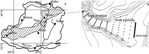
For the present dam farmland, the width, height, length of the check-dam is 4 m, 15 m, and 40 m, respectively, and the length of the dam farmland is about 360 m. The area of the catchment from which water in runoff flows into this dam farmland is 0.3 km2. The dam farmland was divided into nine sampling transects (denoted as T 1, T 2,……, T 9, respectively) with equi-distance of 40 m apart along the alluvial direction (b). Each transect had a unique length which was dependent upon the width of dam for that location. For each transect, we had eight sampling plots spaced equally from the beginning to the end on the transect. Therefore, the number of sampling plots totalled 72 for the whole dam farmland.
Sampling and measurement
Soil water content was measured on each sampling plot (b). The soil sampling depth differed with the depth of shallow groundwater table. In this study, soil water sampling was taken 10 cm apart along the soil profile up to the shallow water table and 2288 soil samples were collected, with two duplicates on each plot (samples were part of the mixture of the 10 cm soil volume). Then soil water content was measured gravimetrically under oven-drying at 105cC to constant weight. The soil water content measurement was repeated twice (autumn in 2007 and spring in 2008) so as to find out the possible changes of soil water content and its spatial structure.
Analysis methods
Classical and geostatistical method were combined in this study to characterize spatial variability of soil water content in dam farmland. The descriptive statistics such as the mean, minimum and maximum values, standard deviation (Std), and coefficient of variation (CV) were calculated using SAS software (SAS Institute Inc., Citation1992) and normality was assessed using the one-sample Kolmogorov-Smirnov (KS) test. CV can be used to qualitatively ascertain the magnitute of the spatial variability as weak when CV≤10%, moderate if 10% < CV<100%, and stong when CV≥100% (Nielsen & Bouma, Citation1985). Based on the regionalized variables theory and intrinsic hypothesis, a semi-variogram, λ(h), of n spatial observations z (x i ), i=1, n=1,…n can be expressed as:
For the present study, we fitted the Gaussian model well to the experimental semivariance, which can be expressed as:
The degree of spatial dependence(GD) was calculated as:
Results and discussion
Classical statistical analysis of soil water content
summarizes the classical statistical results of mean soil water content for each transect in autumn and spring. As can be seen, the lowest mean soil water content was found on T 1 and the highest mean water content was found on T 9 in both two seasons, with mean soil water content of 13.61% and 13.57% on T 1 and 17.19% and 16.55% on T 9 for autumn and spring, respectively. Generally, the mean soil water content increased from T 1 to T 9. These results may be related to particle redistribution for coarser ones abundantly concentrated on T 1 and finer particles accumulated on T 9 for the gravity characteristics. Young (Citation1980) stated that the coarse particles (sand fraction) would deposit first in the transporting process. Obviously, T 9 had a longer transporting distance than T 1. Hu et al. (Citation2008) reported that particle-sizes dominated the soil water content greatly with fine particles yielding a high soil water content in this region. That means that the high soil water content is due to the concentration of fine particles. Soil water content varied largely in the dam farmland, and it ranged from 1.0–39.0% in autumn and 2.0–38.1% in spring. When all the soil water content of every soil layer was pooled together, the mean water content in the dam farmland was 16.11 (±0.002)% in autumn and 15.55 (±0.002)% in spring. The soil water content in autumn showed significantly higher values than in spring (p<0.05). Although there was some rainfall and snow melting during the measurement period which could refresh soil water content to some extent, the drought caused by strong wind in spring obviously decreased the soil water content. In , there is an increasing of the CV values with soil drying. This may relate to the soil heterogeneity of dam farmland for the various partile-sizes have different water retention properties. The CV for the sampling transect ranged from 20.6–53.0% in autumn, and 25.6–51.2% in spring. Thererfore, soil water content of all transects belonged to moderate variability, and showed a generally increasing trend from T 1 to T 9 (). Considering the differences in soil depth and the possible scale dependency of soil water content (Western & Blöschl, Citation1999), we calculated the CV values only from soil water content of 0–150 cm (the shallowest sampling depth, T 1) for each transect and plotted them in . This shows that the mean CV values showed an increasing trend from T 1 to T 9 both in autumn and spring. This phenomenon also strongly related to the sedimentary stratification in dam farmland. Approaching the dam body, the appearance of horizontal soil water distributions become more obvious and frequent (). Consequently, the soil water contents showed more spatial variation associated with particle-size redistribution. Moreover, the interquartile range and outliers did not show any trend as the CV values did.
Figure 2. The statistical CV values of 0–150 cm soil layer for each plot on every transect in autumn (Aut) and spring (Spr). The boxplots show median, interquartile range and outliers.
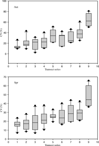
Figure 3. The vertical distribution of soil water content of each transect in autumn (Aut) and spring (Spr) in the dam farmland (error bar is standard error calculated by the soil water content of eight points on the same depth and T 1–T 9 = transect 1–transect 9).
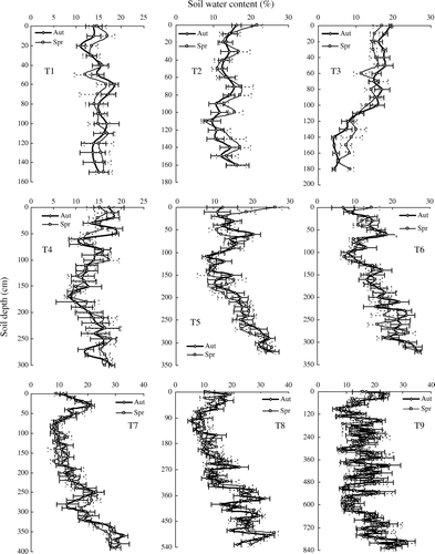
Table I. Statistical values of soil water content on each transect (sampling for each layer with 10 cm).
shows the vertical distributions of soil water on each transect. The fluctuant trends were obviously observed on the nine transects. From T 1 to T 9, the fluctuant trend turned to be more frequent and obvious with the increase of sampling depth. The fluctuant trend of soil water distribution was due to its stratification in dam farmland. The stratification structure of soil water content can be seen in which shows soil water content distribution on soil profile of T 9 in autumn and spring as an example. Usually, soil water content is associated with soil particle component and high soil water content can be largely due to high proportion of fine particles (Hu et al., Citation2008). Consequently, the stratification structure of soil water content may be mainly attributed by the distribution of soil particles along the soil profile, that is to say, coarser particles and finer particles were inter-spaced along the soil profile as a result of different erosion and sedimentation processes under different rain intensities at different times. Therefore, soil water content was relatively high where finer particles accumulated (Young, Citation1980), and coarser soil particles corresponded to somewhat lower soil water content, which can be easily seen by the “white zone” caused by higher sand content. The stratification characteristic of soil particle and soil water content may strongly affect soil hydraulic conductivity and soil water connectivity and therefore soil water movement between neighbouring soil layers with contrasting soil texture (McBratney, Citation1998; Sobieraj et al., Citation2004; Zeleke & Si, Citation2005). Therefore, this may yield important consequences that should be taken into account in modeling soil water budget, soil water movement, and travel time variations in nutrient leaching out of the root zone (Ersahin & Brohl, Citation2006).
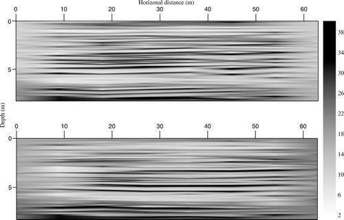
Figure 4. The typical horizontal distribution of soil water on T 9 (transect 9, autumn (top) and spring (bottom)).
Geostatistical analysis of soil water content
Besides the classic methods, we employed geostatistical methods to explore quantitatively the spatial structure of soil water content in dam farmland. Again we only chose soil water content of 0–150 cm for each transect for the comparison purpose. Q-Q plots (not shown) indicated that soil water content of 0–150 cm for all the sampling transects were normally distributed. Therefore, no data transformation was made before semivariance calculation. shows the semivariograms of soil water content on each transect and all the soil water content together for both two seasons fitted by Equation (Equation2). As can be seen, they can be well fitted by Gaussian models except T 9. For T 9, where soil water content presented nugget effect, and no structural variance was found there. We assumed that the lack of a spatial structure on T 9 may relate to the increase in stratification with fine particles. shows the changes of geostatistical parameters, including sill variance (C 0 +C 1 ), nugget variance (C 0 ), structural variance (C 1 ), correlation length (R), and the degree of spatial dependence (GD), from T 1 to T 9 for both two seasons (For T 9, no structural variance and correlation length was shown because of the pure nugget effect model). As can be seen, for soil water content of the two seasons, sill variance (a), nugget variance (b), and structural variance (c) all increased from T 1 to T 9. This means that from back position to front position, total variability of soil moisture along soil depth increased, and this increase consisted of the increase of both random error or variability exsited within the scale less than the least sampling distance (10 cm for the present study) and structural variability. These increases of variability of soil water content from back position to front position was also demonstrated by the increase of CV values mentioned above. For correlation length, it shows a generally decreasing trend from T 1 to T 9. This implies that the distance over which soil water content self-correlated shortened from back position to front position. Generally, back position of dam farmland was more likely to be subjected to sediment deposition than front position because of nearer distance to the main sediment sources. Therefore, after a single rain event and deposition process, the back position tends to deposit thicker sediment than front position. In other words, for the same depth of soil, more sediment deposition processes are needed for the front position. Therefore, much more sedimentation layer occurs and more sources of variability would be introduced for the same depth of soil layer. This also can be found from the distribution of soil water content from T 1 to T 9 in . Obviously, from T 1 to T 9, the soil water content along soil depth fluctuated more frequently. This would therefore inevitably shorten the correlation distance. Except T 9, the GD ranged from 0.338 to 0.582 and no obvious trend was found from back position to front position (e). This indicated that they all showed moderate spatial dependency with soil depth. And the magnitude of increase of nugget variance and structural variance from back position to front position remained almost the same.
Figure 5. The semi-variograms and model fittings of soil water contents of 0–150 cm layer for the entire dam farmland in autumn (Aut) and spring (Spr), T 1–T 9 = transect 1–transect 9.
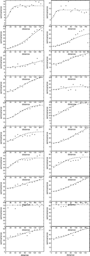
Figure 6. The sill, nugget, structural variance, correlation length and GD for different transects of dam farmland in autumn (Aut) and spring (Spr), T 1–T 9 = transect 1–transect 9.
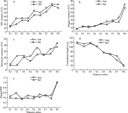
Generally, the sill variance, nugget variance, and structural variance were larger in autumn than spring. For the correlation length, however, it was smaller in autumn than in spring. Considering the wetter conditions in autumn, it seems that the wetter the dam farmland, the larger variability and smaller correlation distance of soil water content with depth. Similar relationship of variability with soil water content condition can be found in other places (Hills & Reynolds,Citation1969; Bell et al.,Citation1980; Robinson & Dean, Citation1993). With respect to GD, however, it did not show much difference for the two seasons.
Soil water content behaved with obvious stratification characteristics in the soil profiles of dam farmland. This phenomenon strongly related to the soil particle-size redistribution properties derived from sediment deposition processes in the dam farmland. This could affect the plant growth, water infiltration, soil salinization and so on. Tillage can disturb soil structure, that would benefit plant growth, water infiltration, and floodwater control. Mean soil water content for each transect generally increased from back position to front position along the alluvial direction, and the lowest mean water content was found on transect 1 and the highest mean water content was on transect 9 both in autumn and spring. This may be helpful to the plant program in dam farmland. For example, we can plant crops which need lots of water in the front position and crops which need less water in the back position.
The classical and geostatistical analysis of soil water content in the dam farmland in two seasons (autumn and spring) would be helpful to the soil water managent in this dam farmland and, possibly, other dam farmlands under the semi-arid climate. The near future consideration should be given to the soil water balance and the way of effective use of soil water resource in the dam farmland from the point of sustainable yield production as well as soil water environmental protection.
Acknowledgements
This work was supported by National Natural Science Foundation of China (Grant no. 90502006) and 2007–2010 Principal Investigator for soil and water transferring and accommodating mechanism in the watershed ecosystem on the Loess Plateau of the Ministry of Education, China. This study was carried out in Shemu Ecological Environment Station of Institude of Soil and Water Conservation of CAS.
Related Research Data
References
- Bell , K.R. , Blanchard , B.J. , Schmugge , T.J. and Witczak , M.W. 1980 . Analysis of surface moisture variations within large field sites . Water Resource Research , 16 : 796 – 810 .
- Cambardella , C. , Mooman , T.B. , Novak , J.M. , Parkin , T.B. , Karlem , D.L. , Turvo , R.F. and Konopa , A.E. 1994 . Field scale variablity of soil properties in central lowa soil . Soil Science of Society of America Journal , 47 : 1501 – 1511 .
- Castillo , V.M. , Mosch , W.M. , Conesa García , C. , Barberá , G.G. , Navarro Cano , J.A. López-Bermúdez , F. 2007 . Effectiveness and geomorphological impacts of check dams for soil erosion control in a semiarid Mediterranean catchment: El Cárcavo . Catena, 01159 , 1 12 .
- Edzer , J.P. and Gees , G.W. 1998 . GSTAT: A program for geostatistical modelling, prediction and simulation . Computer and Geoscience , 24 : 17 – 31 .
- Ersahin , S. and Brohi , A.R. 2006 . Spatial variation of soil water content in topsoil and subsoil of a Typic Ustifluvent . Agricultural Water Management , 83 : 79 – 86 .
- Gao , Z.L Zhang , X.P. 2007 Study on the construction and layout of check-dam in the Loess Plateau The Literature Company of China Publishing [in Chinese]
- Grego , C.R. , Vieira , S.R. , Antinio , A.M. and Rosa , S.C.D. 2006 . Geostatistical analysis for soil moisture content under no tillage cropping system . Scientia Agricola , 63 : 341 – 350 .
- Hebrard , O. , Voltz , M. , Andrieux , P. and Moussa , R. 2006 . Spatio-temporal distribution of soil surface moisture in a heterogeneously farmed Mediterranean catchment . Journal of Hydrolody , 329 : 110 – 121 .
- Hills , T.C. and Reynolds , S.G. 1969 . Illustrations of soil moisture variability in selected areas and plots of different sizes . Journal of Hydrology , 8 : 27 – 47 .
- Hu , W. , Shao , M.A. , Wang , Q.J. , Fan , J. and Reichardt , K. 2008 . Soil water content temporal-spatial variability of the surface layer of a Loess Plateau hillslope in China . Scientia Agricola , 65 : 277 – 289 .
- Lenzi , M.A. and Comiti , F. 2007 . Effects of check dams, reforestation and land-use changes on river channel morphology: Case study of the Rogativa catchment (Murcia, Spain) . Geomorphology , 91 : 103 – 123 .
- McBratney , A.B. 1998 . Some considerations on methods for spatially aggregating and disaggregating soil information . Nutrition Cycling Agroecosyst , 50 : 51 – 62 .
- Moon , S.K. , Woo , N.C. and Lee , K.S. 2004 . Statistical analysis of hydrographs and water-table fluctuation to estimate groundwater recharge . Journal of Hydrology , 292 : 198 – 209 .
- Moret , D. , Arrue , J.L. , Lopez , M.V. and Gracia , R. 2006 . Influence of fallowing practices on soil water and precipitation storage efficiency in semiarid Aragon (NE Spain) . Agricultural Water Management , 82 : 161 – 176 .
- Nielsen , D. R. Bouma , J. 1985 . Soil spatial variability . Pudoc Wageningen , 2 30 .
- Robinson , M. and Dean , T.J. 1993 . Measurement of near surface soil water content using a capacitance probe . Hydrological Processes , 7 : 77 – 86 .
- SAS Institute Inc . 1992 . The MIXED procedure North Carolina , http://www.sas.com .
- Sobieraj , J.A. , Elsenbeer , H. and Cameron , G. 2004 . Scaledependency in spatial patterns of saturated hydraulic conductivity . Catena , 55 : 49 – 77 .
- Shah , T. , Molden , D. , Sakthivadivel , R. and Seckler , D. 2000 . The global groundwater situation: Overview of opportunities and challenges , Colombo, , Sri Lanka : International Water Management Institute Publishing .
- Svetlitchnyi , A.A. , Plotnitskiy , S.V. and Stepovaya , O.Y. 2003 . Spatial distribution of soil moisture content within catchments and its modelling on the basis of topographic data . Journal of Hydrology , 277 : 50 – 60 .
- Tang , K.L. , Hou , Q.C. , Wang , B.K. Zhang , P.C. 1993 . The environment background and administration way of wind-water erosion crisscross region and Shenmu experimental area on the Loess Plateau . Memoir of NISWC, Academia Sinica and Ministry of Water Conservation , 18 , 2 15 . in Chinese
- Western , A.W. and Blöschl , G. 1999 . On the spatial scaling of soil moisture . Journal of Hydrology , 217 : 203 – 224 .
- Xu , M. Wang , G. 2000 . To accelerate the construction of check-dams in the Loess Plateau . Yellow River , 22 , 26 . in Chinese
- Xu , X.Z. , Zhang , H.W. and Zhang , O.Y. 2004 . Development of check-dam systems in gullies on the Loess Plateau,China . Environmental Science Policy , 7 : 79 – 86 .
- Young , R.A. 1980 . Characteristics of eroded sediment . Transactions of the ASAE , 23 , 1139 1142 , 1146 .
- Zhang , H.J. , Yan , J.P. Zhou , L.H. 2007 . The influence of Loess Plateau soil-saving dam on water resources: An example of typical soil-saving dam of Jiuyuangou in suide county . Journal of Northwest University (Natural Science Edition) , 37 , 475 478 . in Chinese
- Zeleke , T.B. and Si , B.C. 2005 . Scaling relationships between saturated hydraulic conductivity and soil physical properties . Soil Science Society of America Journal , 69 : 1691 – 1702 .