Abstract
Terrestrial stocks of soil carbon (C) are an important part of the global C budget, and are considered in the Kyoto Protocol. However, there have been few studies in forested regions over the influence of land-use changes on volcanic soils (Andisols) and its simulation through models. The objective of this study was to determine the influence of native forest, pine plantation, and pasture on the C content and organic matter quality in an Andisol of the Chilean Patagonia, and to simulate the effects using the CO2FIX model. The model was calibrated to each land-use area, and C content was determined in lenga (Nothofagus pumilio) and pine (Pinus ponderosa) trees using previously derived allometric equations, and in pasture by direct measurement. The C content was measured in soils (0–100-cm depth) (Typic Hapludands; Umbric Andosols), and the light (>212 µm), intermediate (212–53 µm), and heavy (<53 µm) fractions of organic matter (0–40-cm depth) which have progressively lower labilities. Total C (vegetation + soil) in the lenga forest was greater than in the pine plantation or pasture, but the C content in soil was greater in the pasture than in the other areas. Over all sites, there was more C in the light fraction than in the intermediate and heavy fractions at 0–5-cm depth, but C content was greater in the heavy fraction with increasing soil depths. However, the quality of soil organic matter was better in the lenga forest compared with the other sites, as indicated by higher ratios of light fraction C between 0–20- and 20–40-cm depths. CO2FIX adequately simulated the C contents in the vegetation, and recalibration for slower degradation rates of soluble organic compounds in Andisols provided better approximation of C content in soil, but overestimated the content of labile C.
Introduction
There is interest in quantifying and modelling carbon (C) stocks in vegetation and soils because of increasing awareness of global warming and its potential mitigation through C sequestration in terrestrial ecosystems, which is considered in the Kyoto Protocol. Global stocks have been estimated at 1500 and 500 Pg C for soils and plants, respectively, compared with 730 Pg C in the atmosphere. Land-use changes may significantly affect the C cycle, and climate change, through biological processes and feedbacks which determine whether the soil and vegetation act as a ‘source or sink’ for atmospheric C. For example, the CO2 content in the atmosphere has increased by 30% since pre-industrial times, and this rise has been attributed to the combustion of fossil fuels, and to deforestation. (IPCC, Citation2001). Consequently, deforestation in remote regions of the world, such as southern Chile, may have affected the local terrestrial C stocks, as well as influenced the concentration of atmospheric CO2.
The Aysén Region of Chile
The Aysén Region of the Chilean Patagonia is located between latitudes 44° and 49° S, and includes 110 000 km2 of forested mountain ranges, volcanoes, and valleys with numerous lakes and rivers. Approximately 25% of the region is protected as wildlife reserves or national forests. The forest is classified as Humid Boreal, and the principal trees include evergreen (2.2 million hectares), coigüe (Nothofagus dombeyi) (0.6 million hectares), lenga (N. pumilio) (1.4 million hectares), and Guaitecas cypress (Pilgerodendron uviferum) (0.5 million hectares), but the forest composition in a given area is determined by the climatic gradient between the mountains and the coast, as well as by local microclimatic conditions (Silva, Citation2004; SERPLAC, Citation2005). Although glaciers covered much of the region during the Pleistocene, more recent deposits of volcanic breccias and ash are the parent materials of many soils that are found in the region (Ferrando & Muñoz, Citation1979).
The region is transversally classified into several eco zones based on physiographic-climatic characteristics that grade from the Temperate Humid Zone along the coast, to the Cold Steppe Zone near the Chile-Argentina border (Silva, Citation2004). The climate of the Intermediate Temperate Zone of interest has a mean annual precipitation that ranges from 900–1300 mm, with the lower values generally found in areas more distant inland from the coast; and mean monthly temperatures of 12–14 °C in the summer (December to February) and 2-3 °C in winter (June to August). November to February is normally frost free, and may include strong westerly and southwesterly winds. Representative areas of the Intermediate Temperate Zone include the Simpson Valley, Coyhaique, and Emperador Guillermo (Silva et al., Citation1999).
Change of soil use
The native forest that once covered large portions of the Aysén Region has been reduced to an area of 4.7 million hectares (43% of the region) because between 1920 and 1940 many areas were burned by settlers in order to create pastures and to claim ownership of lands (Veblen et al., Citation1995). Overgrazing of the pastures and transitional areas has also caused soil erosion and further degradation of the adjoining native forest (Silva, Citation2004). In some areas, sloping soils are so severely eroded that it has become difficult to reestablish the native forest, either by natural means or by human intervention (Ortega & Rodríguez, Citation1994). However, forest plantations of introduced species, principally Pinus ponderosa, Pseudotsuga menziesii, and Pinus contorta, have been made on approximately 27 000 hectares of degraded soils, but other cleared areas continue to be used as pastures (Silva, Citation2004).
In general, volcanic soils (Andisols), such as those found in southern Chile, form in humid temperate climates and have unique properties compared with nonvolcanic soils, including a dark color of the A horizon due to the high content of organic matter caused by the accumulation of stable Al, Fe–humus complexes (Shoji et al., Citation1993). Other properties include: low bulk density, fine crumb or granular structure, the presence of poorly crystalline clay (allophane or imogolite) having a pH-dependent charge and high specific surface area, high content of water at 1500 kPa tension relative to the measured clay content, low exchangeable bases, and elevated retention of P (Wada, Citation1985). Although Andisols cover just 0.84% of the world's land surface, they are an important land resource because many occur in areas of the Pacific Rim that have a high density of population (Shoji et al., Citation1993). Intensive use of volcanic soils in central Chile has been shown to significantly decrease the organic matter (and C) content, and diminish the overall soil quality, principally due to lower return of organic debris to soil, lower recycling of plant nutrients, excessive oxidation of soil organic matter (SOM), and erosion (Sandoval et al., Citation2003; Zagal & Córdova, Citation2005).
A previous investigation in New Zealand found lower contents of C and N in volcanic soil (Typic Udivitrands; 0–20-cm depth) under a 19-year plantation of Pinus radiata than under broad-leaf native forest or pasture (Ross et al., Citation1999). In southern Chile, near Paillaco, the C content in volcanic soil (0–10-cm depth) was higher under pasture (6.7 kg C m−2) than under native forest of Nothofagus oblique (5.8 kg C m−2) and plantation of Pinus radiata (4.3 kg C m−2), but the rate of C mineralization was greater in soil under native forest, with decreasing rates in soils of pine plantation and pasture, respectively (Huygens et al., Citation2005). Additionally, the conversion of native forest into pastures and crops on volcanic soils of southern Chile has been found to significantly lower the content of N in high-molecular-weight fractions of SOM (humin and humic acid) (Borie et al., Citation2002).
Fractions of soil organic matter
Organic matter can be fractionated in the laboratory according to its lability, which refers to the relative ease by which it can be degraded by soil microorganisms thereby releasing N and other nutrients that can be subsequently used by plants. Lability decreases with increasing aromaticity of the fraction, greater occlusion within soil aggregates, or adsorption to clay minerals (Christensen, Citation2001; Krull et al., Citation2003). The most labile fraction has been used as an indicator of sustainable management because the amount in soil changes on a monthly to yearly basis depending upon vegetation, management, and the balance between the additions of plant residues and their rate of decomposition in soil. The most labile fraction has been designated as the mineralizable C, microbial biomass, particulate organic matter, and also the light fraction with a diameter >212 µm (Powlson, Citation1994; Christensen, Citation2001; Zagal et al., Citation2002). The intermediate fraction of SOM is less labile and is associated with macro-aggregates in soil (212–53 µm in diameter), and the heavy fraction is the most stable and is associated with micro-aggregates in soil (<53 µm in diameter) (Balesdent et al., Citation1991; Christensen, Citation2001). In a previous investigation, the mean residence time of organic C was 100 years in the light and intermediate fractions, and 575 years in the heavy fraction (Monreal et al., Citation1997). In volcanic soil (Typic Haploxerands) of central Chile, the contents of light fraction C and total C (0-20-cm depth) decreased with increasing intensity of agricultural management (Zagal et al., Citation2002), and the ratio of C content in the light fraction between 0–20- and 20–40-cm depths has been used as an indicator of sustainable management (Stolpe et al., Citation2008).
The CO2FIX Model
The CO2FIX model was developed to estimate the quantity and fluxes of C in natural forests and plantations, silvo-pastoral systems, and soils to determine the number of transferable C credits according to the Kyoto Protocol (Schelhaas et al., Citation2004). In general, the model uses annual steps to estimate the C content in trunks, branches, leaves, roots, etc. based on user-input parameters of climate, tree species, and management. The model includes the sub model YASSO that uses basic climatic data and estimates of forest-litter production and litter quality to determine the C content in soil (0-100-cm depth) and fractions of organic matter. The sub model fractions have progressively slower rates of C turnover in soil and include soluble compounds (<0.82 year−1), cellulose (0.30 year−1), lignin-like compounds (0.22 year−1), humus 1 (0.012 year−1), and humus 2 (0.0012 year−1) (Liski et al., Citation2005).
The objective of this study was to determine the influence of lenga forest, pine plantation, and pasture in the Chilean Patagonia on the total C content and organic matter quality in volcanic soil, and to calibrate the CO2FIX model to simulate C contents in the soil and vegetation.
Materials and methods
Site description
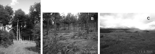
The study area was located in the Mano Negra Sector, 20 km north of the city of Coyhaique, Chile (Lat. S 45°25′, Long. W 72°00′). The area has a western exposed slope (6-8%), an elevation of 730 m above sea level, and adjacent land uses (200 m apart) that include: 1) 150 + -year stand of unmanaged lenga forest (Nothofagus pumilio) (100 ha); 2) 16-year stand of pine plantation (Pinus ponderosa) (5 ha); and 3) 50 + -year pasture (5 ha) (). Originally, the entire study area was covered with indigenous forest (mostly Nothofagus pumilio) before the pasture established itself in the sectors that were burned, as previously described, and the pine plantation was later established over pasture.
Figure 1. Sites of lenga forest (Nothofagus pumilio) (A), pine plantation (Pinus ponderosa) (B), and pasture (C) on volcanic soil (Typic Hapludands; Umbric Andosols) in the Chilean Patagonia.
The pasture is currently used for cattle grazing (2 cows ha−1), and consists of a mixture of perennial grasses (Dactylis glomerata, Holcus lanatus, Poa pratensis), perennial leguminous plants (Trifolium pratense, T. repens), and other accompanying species. The pasture was fertilized during the 2004-2005 growing season with 16 kg N ha−1, 30 kg Mg ha−1, and 79 kg S ha−1; and in 2005-2006 with 24 kg N ha−1, 17 kg Mg ha−1, and 77 kg S ha−1. The pine plantation was established in 1991 with a density of 2000 trees ha−1 and in 2003 it was thinned to 800 trees ha−1. In March 2006 (the beginning of this investigation), the average tree height and diameter at breast height (DBH) were 6.3 m and 17.3 cm, respectively. In March, 2006, the lenga forest had a density of 780 trees ha−1, average tree height of 23.7 m, and DBH of 32.5 cm.
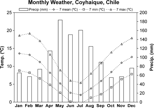
The study area has climatic conditions that are classified as ‘Trans Andean with Steppe regeneration’ (DMC, Citation2009), with dry summers and cool, humid winters (), and the mean annual temperature and precipitation are 8.1 °C and 1206 mm, respectively. Normally, only 15% of the annual precipitation occurs between December and February, coinciding with the windiest and warmest period (Silva et al., Citation1999; DGF, Citation2008). The soil formed from relatively unaltered volcanic ash deposits and is characterized as deep, well drained, moderately acidic (Silva et al., Citation1999), and has been classified as Typic Hapludands (Soil Survey Staff, Citation2006), or Umbric Andosols (IUSS Working Group, Citation2006).
Figure 2. Mean monthly precipitation and temperatures (maximum, minimum, and median) near Coyhaique, Chile (Lat. S 45° 38′, Long. W 72° 07′ 310 m elevation) (DGF, 2008) as input into the CO2FIX model.
Soil analysis
The experimental design was Completely Randomized, and soil samples were collected in March, 2006 at three sub sites within the lenga forest, pine plantation, and pasture (0.5-ha areas). Representative, bulk samples of soil were taken at 0–5-, 5–10-, 10–20-, and 20–40-cm depths in each sub site, stored in plastic bags and transported to the laboratory where they were air dried. The SOM was fractionated using a modified procedure from Balesdent et al. (Citation1991) in which the soil was mechanically dispersed, followed by a physical separation through wet sieving. Briefly, 50 g of air-dried soil and 10 small glass balls (6-mm diameter) were placed in 180 ml of distilled water and shaken in a rotator agitator (REAX 2, Heidolph Instrument, Schwabach, Germany) at 50 cycles per minute for 16 hours, causing the mechanical rupture of soil macro aggregates. Then, the soil was wet sieved through 53- and 212-µm stainless steel sieves thereby separating three fractions of organic matter: a) light fraction (above 212 µm) that was separated from the sand by flotation and sedimentation in water, b) intermediate fraction (53–212 µm), and c) heavy fraction (below 53 µm) without ultrasonic dispersion. The C content of the light, intermediate and heavy fractions was then measured by dry combustion (Wright & Bailey, Citation2001), and the ratio of C content in the light fraction between 0-20- and 20-40-cm depths was calculated as an indicator of sustainable management, whereby soil quality decreases with lowering ratios (Stolpe et al., Citation2008). Additional, deeper, samples of soil were collected in the sub sites, and the total C content in whole soil (0–100-cm depth) was determined by dry combustion (Wright & Bailey, Citation2001). Analysis of variance (ANOVA) and least significant difference (LSD) of means were used to test for differences among soils of the lenga forest, pine plantation, and pasture (Steele & Torrie, Citation1980).
Soil morphology was described at a sub site in each land-use area in order to check the soil uniformity and classification among the lenga forest, pine plantation, and pasture. Representative, bulk samples were taken at 0–20-, 20–40-, 40–60-, 60–80-, and 80–100-cm soil depths (Soil Survey Staff, Citation2004). In the laboratory, the soil samples were air dried and sieved (2-mm mesh) for the subsequent characterization analyses. Soil texture was determined using the hydrometer method (Day, Citation1965), soil water contents at 33 and 1500 kPa were measured using a pressure plate apparatus, soil pH was determined using a 1:1 mixture of soil and water, and the % P sorption was measured in the soil (Soil Survey Staff, Citation2004). Effective cation-exchange capacity (ECEC) was measured using 1 N NH4OCOCH3 for extraction of the exchangeable cations Ca, Mg, K, and Na, and 1 N KCl for exchangeable Al, and available N (NO3–N), P (Olsen), and K were also measured in the soils (Sadzawka et al., Citation2006). Additionally, the content of 13C and total C in the soils (0–100-cm depth) was determined using an elemental analyser (ANCA-SL, PDZ-Europa, UK) coupled to an Isotope Ratio Mass Spectrometer (20–20, PDZ Europa, UK), and the 13C/12C ratios were used to obtain the δ13C ‰ values (Huygens et al., Citation2005). For the latter analysis, the surface soil was sampled at finer increments of 0–5, 5–10, and 10–20 cm in addition to the deeper samples to 100 cm.
Tree and pasture biomass
The lenga forest and the pine plantation were inventoried in March, 2006 using five circular plots of 200 m2 that were randomly established in each site, measuring the total height of all the trees in the plots and the DBH using a clinometer and diametric tape, respectively. The measured variables were then used to calculate aerial and subterranean biomass, using existing biomass functions for the climatic zone that were developed for Nothofagus pumilio (Weber, Citation1999; Loguercio & Defossé, Citation2001), and Pinus ponderosa (Gayoso et al., Citation2002). Partitioning of the aerial biomass compartments was as follows: 1) Nothofagus pumilio, 87% consisted of stems, 12% of branches, and 1% of foliage; and 2) Pinus ponderosa, 47% of aerial biomass consisted of stems, 25% of branches, and 28% of foliage. The live ground cover in the lenga forest and pine plantation was estimated at <1 Mg dry matter ha−1 due to extensive litter coverage of leaves and pine needles, respectively.
To obtain the above-ground biomass in the pasture, the vegetation was clipped at ground level from 9 randomly selected 0.25-m2 quadrants. In the laboratory, the vegetative material was dried at 65 °C for 5 days and weighed. To measure the subterranean biomass, the live roots of each quadrant were removed with a spade, rinsed in the laboratory in slow-running water in order to remove soil from the roots, and then dried and weighed as previously described. The above- and below-ground values were summed to calculate the total pasture biomass per hectare.
Calibration of CO2FIX
The C content of the lenga forest, pine plantation, and pasture biomass was simulated using the CO2FIX (v. 3.1) model (Schelhaas et al., Citation2004); and soil using the sub model YASSO (Liski et al., Citation2005). Model calibration to regional climatic conditions included the mean monthly temperature and precipitation of the growing season (August through May) (); with season totals of 2961 Growing Degree Days above 0 °C, 500 mm of potential evapo-transpiration, and 895 mm of precipitation. The weather data were taken from the nearest station located in Coyhaique, which has similar climatic conditions as the study area (DMC, Citation2009). Based on interviews with the landowner, the tree-rotation lengths were input at 150 and 35 years for Nothofagus pumilio and Pinus ponderosa, respectively, with 60% of the pine biomass removed (thinned) after 13 years. The C content in stems, foliage, branches, and roots was set to 50%, and the current annual increments (CAI) of both species were calculated according to published values (Loguercio & Defossé, 2001; Quiroz & Rojas, Citation2003). The pasture was simulated, in effect, by inputting an annual rotation of grass as a ‘tree’ having very small stem volume, no branches, but with a lot of foliage and roots (Schelhaas et al., Citation2004). Other initial soil parameters were taken from the sample files for broadleaf trees, pine, and pasture included in the CO2FIX model (). In each scenario, the model was run for a period representing 300 years, and recalibration was based on comparison of the simulated and measured contents of total C in soil, as is described in the following section.
Table I. Initial vegetative and soil parameters input to the CO2FIX model for the lenga forest, pine plantation, and pasture sites of southern Chile.
Results and discussion
Soils and total carbon
The soil morphology was relatively uniform among the lenga forest, pine plantation, and pasture, as evidenced by the similar sequence of horizons (A1, A2, Bw, BC, C1, C2) (), which was expected considering that the parent material was aerially deposited volcanic ash, the topographic uniformity, and the native forest that once covered the entire sector. However, the lenga forest soil had a thin (2-cm thick) organic horizon on the surface, which was not present in the other sites, and NO3-N, available P, and K were higher in the lenga site (0–20-cm depth) than in the pasture and pine sites (). Overall, the ratios of 1500 kPa water to clay were well above 0.6, which is a characteristic of volcanic soils. High ratios indicate poor dispersion of clay during particle-size analysis, and under measurement of the actual clay content in the soil (Stolpe & Lewis, Citation1990).
Table II. Descriptions of morphology of the volcanic soil (Typic Hapludands; Umbric Andosols) under lenga forest, pine plantation, and pasture in the Chilean Patagonia.
Table III. Chemical properties of the volcanic soil (Typic Hapludands; Umbric Andosols) under lenga forest, pine plantation, and pasture in the Chilean Patagonia.
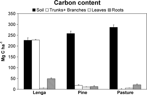
The total C content in soil (0–100-cm depth) was higher (P<0.05) under pasture (286.7±10.8 Mg C ha−1) than those in soil under pine (257.8±10.1 Mg C ha−1) and lenga (226.7±12.5 Mg C ha−1), although the total C in vegetation and soil of the lenga forest (504.7±16.0 Mg C ha−1) was greater than that of both the pine plantation (295.7±10.7 Mg C ha−1) and the pasture (309.2±15.1 Mg C ha−1) (). The lenga forest had similar C content in soil and in the wood (trunks and branches), but the pine plantation and pasture had more C content in the soil than in the biomass component.
Figure 3. Mean carbon content and standard deviation (Mg C ha−1) in volcanic soil (Typic Hapludands; Umbric Andosols) (0–100 cm depth), and vegetation of lenga forest, pine plantation, and pasture in the Chilean Patagonia.
Characterization of soil organic matter
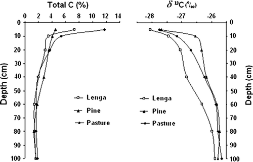
The natural abundance of 13C in soils of the lenga forest, pine plantation, and pasture showed an enrichment beginning at 5 cm depth, possibly associated with an isotopic discrimination during the decomposition of organic residues in soil which resulted in enrichment in the residual C of the heavier isotope (13C) () compared with the vegetative biomass. In contrast with a previous investigation (Huygens et al., Citation2005), the soil of the lenga forest had lower values of δ 13C ‰ throughout the profile compared with the pine plantation and pasture and this may have resulted from the decomposition of organic residues with lower initial content of 13C such as hemicelluloses, cellulose, and lignin, or higher decomposition rates of organic residues in the lenga soil.
Figure 4. Total content of C (%) and δ 13C (‰) in volcanic soil (Typic Hapludands; Umbric Andosols) under lenga forest, pine plantation, and pasture in the Chilean Patagonia.
Physical fractionation of SOM of the lenga forest, pine plantation, and pasture showed that, among all sites, the light fraction (>212 µm) of the surface (0–5 cm) contained more C (P<0.05) than did the intermediate (212–53 µm) and heavy (< 53 µm) fractions (), but there was more C in the heavy fraction at 5–10-, 10–20-, and 20–40-cm depths, which indicated that the SOM was more stabilized (less labile) with increasing soil depth. In general, with increasing soil depth there was no significant difference of C content in each fraction among the lenga, pine, and pasture sites, except that the lenga soil had more C in the intermediate fraction at 0–5- and 5–10-cm depths than did the other soils (P<0.05), and that the pine soil had less C in the heavy fraction at 10–20-cm depth did than the other soils. However, the C content in the light fractions of the pine plantation and pasture may have possibly been elevated by charcoal C (which has a longer residence time in soil) from burning of the native forest (Murage et al., Citation2007). Nevertheless, the ratio of C content of the light fraction between the soil depths of 0-20 and 20-40 cm (C20/40) was higher in soil of the lenga forest (9.35), with decreasing values in the pine plantation (7.16) and pasture (6.33) (P<0.05; LSD = 2.97). Lower ratios have been used to indicate the negative effect of more intensive management on the quality of SOM (Stolpe et al., Citation2008).
Table IV. Mean carbon content and standard deviation (Mg C ha−1) in the light, intermediate, and heavy fractions of organic matter of volcanic soil (Typic Hapludands; Umbric Andosols) under lenga forest, pine plantation, and pasture in the Chilean Patagonia.
Modelling of soil carbon
The first simulation using the CO2FIX model indicated that the C content in vegetation would be higher in the lenga forest than in the pine plantation and pasture, that the soil C contents (0-100-cm depth) would be higher in the pasture than in the other sites, and that the least labile Humus 2 fraction (Liski et al., Citation2005) would be higher in the pasture soil and lower in the lenga soil (). The measured C contents in the vegetation were similar to the simulated values, but the soil C contents () were four to eight times higher than those simulated by the model, and the least labile heavy fraction (<53 µm) was generally similar among the soils (). The soil discrepancies were attributed to the initial calibration of the sub model YASSO that was based on climate and typical decomposition rates of vegetative litter in nonvolcanic soils (Liski et al., Citation2005). However, Andisols have unique properties that are strongly influenced by characteristics of the parent material, such as a high content of organic matter as a result of the stabilization of dissolved organic C by active Al and Fe from volcanic ash (Shoji et al., Citation1993; Huygens et al., Citation2005). Therefore, the first simulation for the lenga forest, pine plantation, and pasture resulted in underestimation of C content of the volcanic soils.
Table V. Carbon content (Mg C ha−1) in vegetation and soil (0–100-cm depth) of lenga forest, pine plantation, and pasture in the Chilean Patagonia, as simulated using the CO2FIX model.
The model was re-calibrated to better simulate C content in volcanic soil of the lenga forest by lowering the KOsol variable (the decomposition rate of soluble organic compounds in soil) of the YASSO sub model (Schelhaas et al., Citation2004; Liski et al., Citation2005) to the minimum value of 0.0001, and the simulation was run again for 300 years (2 rotations of 150 years). The subsequent C content in soil (0–100-cm depth) was 202.6 Mg C ha−1 () which was nearer to, but 11% lower than, the measured value of 226.7 Mg C ha−1 (). Although the CO2FIX model is not structured to permit sequences of different vegetative species in the same simulation, they can be achieved by using the final output of one simulation as the initial conditions for the next. Therefore, in the second simulation for the pasture, the KOsol was similarly set to 0.0001 and the initial soil values were set according to the output soil values for the second simulation of the lenga forest () (justified since pasture followed burning of the native forest). The projected total C content in soil after 50 years of pasture was 289.5 Mg C ha−1, which was 1% above the measured value of 286.7 Mg C ha−1. Then, in the second simulation for the pine plantation the KOsol was set to the minimum and the initial soil values were set according to the output values for the second simulation of the pasture (justified since the pine plantation followed pasture). The projected total C content in soil after 16 years of pine plantation was 286.0 Mg C ha−1, which was 11% above the measured value of 257.8 Mg C ha−1. However, the second simulations for the lenga forest, pasture, and pine plantation indicated that soluble (labile) compounds would be approximately 85% of the total SOM (), while the laboratory fractionation indicated that the labile light fraction (>212 µm) was approximately 55% of total C in the 0–5-cm soil depth, 11% in the 5–10-cm depth, and 7–8% from 10–40-cm depth (). Nevertheless, the simulations may be correct in the sense that soluble C is a major source of organic matter in Andisols, as previously described. Finally, the C content of the biomass of the lenga forest, pasture, and pine plantation was unchanged between the first and second simulations.
The land-use changes in the study area of the Chilean Patagonia have modified the C content in vegetative biomass and volcanic soil, and the results illustrate the relative importance of volcanic soil to store C in the lenga forest, pine plantation, and pasture of the Chilean Patagonia. Although it is doubtful that all of the pastures will one day be reconverted into native forests or pine plantations in order to affect the total C content stored in vegetation and soil, there is growing interest in the use of silvo-pastoral systems as a balance between the economic and environmental concerns of land use in the area. A collateral investigation is currently under way to characterize the effects of this type of management.
Acknowledgements
We sincerely thank Mr Victor Mata for giving us access to his land near Coyhaique, Chile for data collection. This study was funded by a grant (Project No. 205.123.007-ISP) from the Direction of Investigations of the University of Conception and the Center for Investigations of Ecosystems in the Patagonia (CIEP).
References
- Balesdent , J. , Pétraud , J.-P. , & Feller , C. 1991 . Effets des ultrasons sur la distribution granulométrique des matières organiques des sols . Science du Sol , 29 , 95 106 (in French) .
- Borie , G. , Peirano , P. , Zunino , H. and Aguilera , S. 2002 . N-pool in volcanic ash derived soils in Chile and its changes in deforested sites . Soil Biology and Biochemistry , 35 : 197 – 198 .
- Christensen , B. 2001 . Physical fractionation of soil, and structural and functional complexity in organic matter turnover . European Journal of Soil Science , 52 : 345 – 353 .
- Day , P.R. 1965 . “ Particle fractionation and particle size analysis ” . In Methods of Soil Analysis, Physical and Mineralogical Properties , Edited by: Black , C.A. 545 – 567 . Madison, WI : American Society of Agronomy .
- DGF 2008 . Interactive Meteorology of Chile. Geophysics Department, Faculty of Science and Mathematics, University of Chile . http://www.atmosfera.cl/ (accessed in December, 2008) .
- DMC . 2009 . Climates of Chile Directorate of Meteorology, Government of Chile Santiago, , Chile . http://meteochile.cl/climas/climas.html (accessed in February, 2009) .
- Ferrando , F. , & Muñoz , M. 1979 . Perspectives for Development of the Resources of the Region of Aysén Publication N° 26, IREN - Agricultural Ministry, Government of Chile Santiago, , Chile (in Spanish) 69 .
- Gayoso , J. , Guerra , J. , & Alarcón , D. 2002 . Content of carbon and functions of biomass in native and exotic species . In : Urrutia , J. Measurement of the Capacity to Capture Carbon in Chilean Forests, and its Promotion in the World Market . Project FONDEF D98I1076, Technical Report. University Austral, Valdivia, Chile, 157 pp. (in Spanish) .
- Huygens , D. , Boeckx , P. , Van Cleemput , O. , Oyarzún , C. and Godoy , R. 2005 . Aggregate and soil carbon dynamics in south Chilean Andisols . Biogeosciences , 2 : 159 – 174 .
- IPCC 2001 . Climate change 2001: the scientific basis In Houghton , J.T. , Ding Y. , Griggs , D.J. , Noguer , M. , van der Linden , P.J. , Dai , X. , Mashell , K. , & Johnson , C.A. Contribution of Working Group I to the Third Assessment Report of the Intergovernmental Panel on Climate Change . Cambridge University Press , Cambridge, , UK , 881
- IUSS Working Group WRB 2006 . World reference base for soil resources 2006 , 2nd edn , World Soil Resource Report No. 103. FAO, Rome , 132 pp.
- Krull , E.S. , Baldock , J.A. and Skjemstad , J.O. 2003 . Importance of mechanism and processes of the stabilization of soil organic matter for modeling carbon turnover . Functional Plant Biology , 30 : 207 – 222 .
- Liski , J. , Palosuo , T. , Peltoniemi , M. and Sievänen , R. 2005 . Carbon and decomposition model YASSO for forest soils . Ecological Modelling , 189 : 168 – 182 .
- Loguercio , G. , & Defossé , G. 2001 . Equations for aerial biomass, expansion and reduction factors of lenga Nothofagus pumilio (Poepp. Et Endl.) Krasser, in El Sol del Chabut, Argentina . The Book of Summaries of the International Symposium of Measurement and Monitoring of the Capture of Carbon in Forestry Ecosystems, Validivia, Chile (pp. 1-11). October 18–20, 2001 (in Spanish) .
- Monreal , C.M. , Schulten , H.R. and Kodama , H. 1997 . Influence of aggregate architecture and minerals on living habitats and soil organic matter . Canadian Journal of Soil Science , 77 : 379 – 388 .
- Murage , E.W. , Voroney , P. and Beyaert , R.P. 2007 . Turnover of carbon in the free light fraction with and without charcoal as determined using the 13C natural abundance method . Geoderma , 138 : 133 – 143 .
- Ortega , R. & Rodríguez , I. 1994 . Manual of Environmental Management . Mapfre Foundation Madrid, , Spain 364 (in Spanish) .
- Powlson , D.S. 1994 . “ The soil microbial biomass: before, beyond and back ” . In Beyond the Biomass: Compositional and Functional Analysis of Soil Microbial Communities , Edited by: Ritz , K. , Dighton , J. and Giller , K.E. 3 – 20 . Chichester, , UK : John Wiley and Sons .
- Quiroz , I. , & Rojas , Y. 2003 . Ponderosa pine and Oregon pine: conifers for southern Chile . INFOR-Agricultural Ministry, Government of Chile Valdivia, , Chile , 316 pp. (in Spanish) .
- Ross , D. , Tate , K. , Scott , N. and Feltham , C. 1999 . Land use change: effects on soil carbon, nitrogen and phosphorus pools and fluxes in three adjacent ecosystems . Soil Biology and Biochemistry , 31 : 803 – 813 .
- Sadzawka , A. , Carrasco , M. , Grez , R. , Mora , M. , Flores , H. , & Neaman , A. 2006 . Recommended Analytical Methods for Chilean Soils . INIA-Agricultural Ministry, Government of Chile Santiago, , Chile , 164 (in Spanish) .
- Sandoval , M. , Stolpe , N. , Zagal , E. , Mardones , M. , & Junod , J. 2003 . Carbon sequestration in agricultural and its importance in global warming . Theoria , 12 , 65 71 (in Spanish) .
- Schelhaas , M.J. , van Esch , P.W. , Groen , T.A. , de Jong , B.H.J. , Kanninen , M. , Liski , J. , Masera , O. , Mohren , G.M.J. , Naaburs , G.J. , Palosuo , T. , Pedroni , L. , Vallejo , A. , & Vilen , T. 2004 . CO2FIX V 3.1. – Description of a Model for Quantifying Carbon Sequestration in Forest Ecosystems and Wood Products, ALTERRA Report 1068 . Wageningen , The Netherlands , 122 pp.
- SERPLAC 2005 . Atlas of the Aysén Region, 1:50,000 . Planning Ministry, Government of Chile Santiago, , Chile , 43 pp. (in Spanish) .
- Shoji , S. , Nanzyo , M. , & Dahlgren , R. 1993 . Volcanic Ash Soils, Genesis, Properties and Utilization . Elsevier , New York, NY , 288 pp.
- Silva , F. 2004 . Final Report on the Ecological Status of the Aysén Region SAG-Agricultural Ministry, Government of Chile Santiago, , Chile , 143 pp. (in Spanish) .
- Silva , F. , Ahumada , M. , & Cerda , J. 1999 . Guide for Pasture Condition in the Intermediate Temperate Ecological Region of Aysén . SAG-Agricultural Ministry, Government of Chile Santiago, , Chile , 127 pp. (in Spanish) .
- Soil Survey Staff 2004 . Soil Survey Laboratory Methods Manual, Soil Survey Investigations Report N° 42 . Natural Resources Conservation Service, USDA Washington, DC , 700 pp.
- Soil Survey Staff 2006 . Keys to Soil Taxonomy . Natural Resources Conservation Service, USDA Washington, DC , 332 pp.
- Steele , R.G.D. , & Torrie , J.H. 1980 . Principles and Procedures of Statistics, a Biometrical Approach , 2nd edn McGraw-Hill , New York, NY , 633 pp.
- Stolpe , N.B. and Lewis , D.T. 1990 . Mineralogical implications of high ratios of 1500 kPa water content to percent measured clay for two soils of western Nebraska . Geoderma , 47 : 1 – 16 .
- Stolpe , N. , Muñoz , C. , Zagal , E. and Ovalle , C. 2008 . Modeling soil carbon storage in the Espinal agroecosystem of central Chile . Arid Land Research and Management , 22 : 148 – 158 .
- Veblen , T.T. , Kitzberger , T. , Burns , B. , & Rebertus , A. 1995 . Perturbations and dynamics of regeneration of Andean forests in southern Chile and Argentina . In : Armesto , J. , Villagran , C. , & Arroyo , M. Ecology of the Native Forests of Chile (pp. 169 198 ). University Editorial, University of Chile Santiago, , Chile (in Spanish) .
- Wada , K. 1985 . “ The distinctive properties of Andosols ” . In Advances in Soil Sciences , Edited by: Stewart , B.A. Vol. 2 , 174 – 229 . New York, NY : Springer Verlag .
- Weber , M , 1999 . Carbohydrate reserves in primary forest of Nothofagus in Tierra del Fuego . Forstwissenschaftliches Centralblatt , 118 , 156 166 (in German) .
- Wright , A.F. and Bailey , J.S. 2001 . Organic carbon, total carbon, and total nitrogen determinations in soils of variable calcium carbonate contents using a Leco CN-2000 dry combustion analyzer . Communications in Soil Science and Plant Analysis , 32 : 3243 – 3258 .
- Zagal , E. , & Córdova , C. 2005 . Indicators of quality of organic matter in a cultivated Andisol soil . Agricultura Técnica (Chile) , 65 , 186 197 (in Spanish) .
- Zagal , E. , Rodríguez , N. , Vidal , I. , & Flores , B. 2002 . The light fraction of organic matter in a volcanic soil under different agricultural management as an indicator of changes in the labile organic matter . Agricultura Técnica (Chile) , 62 , 284 296 (in Spanish) .