
Abstract
Land taken by artificial surfaces has an impact on the quality of life and ecosystems. To reduce possible negative impacts of land take, the European Commission proposed setting a milestone objective for 2020 in terms of future rates of land take.
This paper describes a methodology to model the impacts of the 2020 land-take milestone proposed in the RERM in the European Union 27 MS. An integrated modelling framework was configured to assess the spatial impact of two land-take scenarios: a ‘Reference’ scenario, which is driven by demographic and economic trends, and a ‘Target 0’ scenario that follows the 2020 land-take milestone proposed in the RERM. We conclude that the implementation of the 2020 land-take milestone, by reducing future land take in Europe, will foster more efficient use of land (less land taken for the same activity levels) and minimise negative impacts on non-artificial land uses.
1. Introduction
The World Urban Prospects expected an increment of 2.5 billion people to the urban population across the planet by 2050. This rapid growth causes significant changes in the landscape of cities. A major feature of fast growing cities is urban sprawl, which is the principal driver of occupation of larger areas of land, accompanied by serious problems including irreversible changes on the ecosystems, inefficient land use, high car dependency and low density (United Nations, Department of Economic and Social Affairs Citation2014).
In Europe, cities are becoming less dense, meaning that the urban sprawl thus continues. Inadequately managed urbanisation leads to an increase in ‘land take’, soil sealing, fragmentation of habitats and health-related issues (EEA Citation2015). In order to better manage the use of land, appropriate spatial planning policies and recommendations should build a different type of urban landscape structure and space.
The urban and spatial planning in the European Union (EU) territory is under the subsidiarity principle, which means that all the decisions taken on land and urban planning are under the responsibility of the national and regional governments of the Member States. However, the majority of the European policies have a direct or indirect effect on urban development and a part of them reflect the need for better planning to control urban growth and the extension of infrastructures. In particular, the European Commission's Roadmap to a Resource Efficient Europe (COM(2011) 571) proposes an important policy measure related to the sustainable management of land and soil which is expected to affect the urban development in Europe: ‘no net land take by 2050'. In addition, it calls for a ‘2020 milestone’ which states that “By 2020 (…) the rate of land take [should be] on track with an aim to achieve no net land take by 2050” (European Commission Citation2011a, 15). This policy objective aims to preserve the land as a resource by reducing the pressures of the urban development on the natural and managed landscapes. Nevertheless, due to the subsidiarity principle this policy objective remains a non-binding measure aiming to raise the awareness of the policymakers on the necessity to preserve the land resource. At national level, although the increasing adoption of strategic instruments to promote a sustainable development (European Commission Citation1999; European Commission Citation2010), most of the initiatives on land take also remain of an orientative and informative nature.
Effective policy decisions require a clear understanding of the links between objectives and targets of the RERM and the indicators that can meaningfully report on progress towards those targets. For an indicator to help achieve a specific target, the indicator must be adjusted to the target (Tittensor et al. Citation2014). The indicator proposed in the RERM is the average annual land take (European Commission Citation2011b). The concept of ‘land take’ was initially defined as the total amount of land that is to be occupied by completed road (Byron Citation2000). Later, the terminology ‘land take’ was adapted and extended to other artificial land uses, defined as ‘the amount of land taken by urban and other artificial development’ (European Environment Agency Citation2004).
The concept of ‘land take’ has been frequently used to measure the impact of regional, national policies and public expenditures (Zoppi and Lai Citation2014), the pressure from the development of urban land on natural and managed landscapes (Tóth Citation2012; Gardia et al. Citation2014), the loss of crop production (Jiang, Deng, and Seto Citation2013; Ceccarelli et al. Citation2014), the consequences on carbon emissions through the removal of vegetation (Hutyra et al. Citation2011), the direct habitat loss (Byron et al. Citation2000; Geneletti Citation2006; Tratalos et al. Citation2007), and landscape fragmentation (Jaeger et al. Citation2007), to explore the temporal and spatial characteristics of urban expansion (Kasanko et al. Citation2006; Xiao et al. Citation2006; Huang, Lu, and Sellers Citation2007; Salvati Citation2014).
In the RERM, the objective to stop net land take by 2050 is used to stimulate measures that are beneficial to reduce the amount of land used for artificial purposes in Europe Among the measures to mitigate the land take, Member States, specifically the regional/local authorities, frequently use spatial planning instruments, which authorise or restrict certain developments. In specific, encouraged the development of the inner-cities, increasing the land-use intensity and recycling the previously developed land for economic uses (e.g. commercial, housing, recreational uses) or to create green areas by bringing the artificial land back to nature (renaturalisation of the brownfields) (European Commission Citation2014). At national level, there are few countries that have put in place quantified objectives addressing the reduction of the land take at regional or local level. For example, Germany, Luxemburg and Austria have defined quantitative objectives to limit the land take (max. 30 ha/day by 2020 in Germany, 1 ha per day by 2010 in Austria and 1 ha per day by 2020 in Luxemburg). The central government is responsible for defining the target and monitoring its progress. Afterwards, the target is translated into objectives at regional or local level for implementation by the responsible authority, who typically delivers the planning permission (Decoville and Schneider Citation2015).
Decoville and Schneider (Citation2015) have shown that the existent objectives or strategies to reduce the land take across the Member States are very much influenced by distinct cultural, historical and economic contexts and it appears too simplistic to address this variety at the scale of the EU as a whole (Decoville and Schneider Citation2015). In this sense, there is a need to find a monitoring system which measures the size of the effort needed by the Member States and regions to reach the 2020 land-take milestone, taking into account the specificities of national and regional social, economic and political contexts which have a strong impact on land management practices.
Projecting the impacts of prospective policies is one possible way to determine which policy alternatives yield desired outcomes (Nicholson et al. Citation2012). During the last decade, integrated land-use modelling has been used to envisage the future landscape under different scenarios and assess the impact of policies (Koomen, Rietveld, and Nijs Citation2007; Overmars et al. Citation2013).
Previous studies focused on the impact of the land take at local and regional scale (Zoppi and Lai Citation2014; Ceccarelli et al. Citation2014; Decoville and Schneider Citation2015); few studies, however, are conducted at European level (Tóth Citation2012; Gardia et al. Citation2014) and none has so far estimated the impact of the RERM 2020 land-take milestone in Europe at regional and Member State level.
This paper aims to assess the feasibility of reaching the 2020 land-take milestone of the RERM. To this end we used an integrated modelling framework, hereinafter referred to as ‘LUISA’, to translate the European 2020 land-take milestone in orientative and quantitative targets at member state and regional level, and to assess the potential impact of this measure on the development of the built-up areas. The strength of our approach is the use of an integrated modelling frame with, at its core, a fine spatial and temporal resolution land-use model at European level to project forwards the impacts of the 2020 land-take milestone (Lavalle et al. Citation2011). This allows us to explore future built-up development according to one policy scenario which is compared with a Reference scenario. The policy scenario, herein called Target 0, assumes that future land take is on the track to achieve no net changes by 2050, whereas in the reference scenario the foreseen land take is driven by demographic and economic trends. Both scenarios take into account the same assumptions on land-use impacts on agricultural and forestry development in Europe. Using this approach we can both perform the impact assessment of the proposed policy and verify the ability of indicators to detect changes in built-up land take.
To this purpose we first introduce how LUISA was configured to model the impact of the Reference and the Target 0 scenarios and, subsequently, we use a set of indicators that aims to address the following questions:
How is the land take in the EU-27 affected by the 2020 land-take milestone: “no net land take by 2050”? Which are the main drivers of the built-up land take?
Is it feasible to reach the milestone or is it an unrealistic goal?
Will the 2020 land-take milestone improve the land-use intensity in Europe?
What is the impact of the 2020 land-take milestone on other land-uses?
2. Methods
2.1. Land-Use-based Integrated Sustainability Assessment Platform (LUISA)
The Land Use-based Integrated Sustainability Assessment Platform (LUISA) is an integrated modelling approach which is used in policy decision support by exploring the future effect of specific measures on the European territory (EU-27). LUISA was developed to provide a vision of possible futures and allows comparisons between simulated scenarios and policy options at European level (Lavalle et al. Citation2011; Mubareka et al. Citation2011; Mubareka et al. Citation2013; Maes et al. Citation2014; Jacobs-Crisioni et al. 2016; Baranzelli et al. Citation2015).
LUISA integrates a chain of models to describe the effects of policy measures to land-use changes. The main outputs of LUISA are projected land-use maps which are the result of configuration choices reflected in three main modules. Each module has a specific role in overall impact assessment: definition of the land-use demands, spatially explicit allocation and land-take assessment module ().
Figure 1. Representation of the methodology adopted using the LUISA platform for the assessment of the land-take milestone proposed in the RERM.
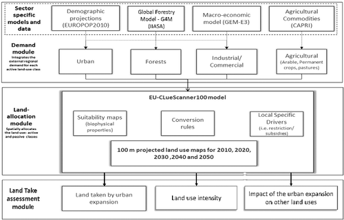
The land-use demand is the expected land surfaces required to support future societal and economic activities (Batista e Silva et al. Citation2014). Sector specific models and the historical land-use data are used to report the proportion of additional land foreseen to be developed for any given sector and year at regional level: agriculture (arable, pasture and permanent crops), urban area (residential, sport and leisure), industrial/commercial (industrial, commercial and services built-up) area and forest.
The allocation module is the core of the LUISA platform and was originally based on the CLUE model (Verburg and Overmars Citation2009) and the Land Use Scanner (Hilferink and Rietveld Citation1999). At this stage, the aggregated amount of each simulated land use is spatially distributed to a single land use at 100 m pixel resolution, considering the bio-physical characteristics, neighbourhood factors (inertia, attraction or repulsion between land uses), and policy-based restrictions, subsidies and European regulations.
The land-take assessment module involves the computation of indicators to evaluate the effect of a policy measure implemented upstream: the 2020 land-take milestone. At this stage the land-use information for the two scenarios was used as an input for assessing the progress towards reaching the 2020 land-take milestone.
The focus of this paper is on the demand module where the land-take scenario has been configured and on the impact assessment module.
2.2. Land-take and land-use classes
The assessment of the 2020 land-take milestone was based on the comparison of two scenarios: a reference scenario which projects future land-use changes based on projection of population and economic growth; and a Target 0 scenario which implements the ‘2020 land take milestone’ proposed in the RERM to achieve the 2020 land-take milestone as an alternative measure. The two scenarios have common assumptions, with the exception of the assumed urban and industrial development, where land take is expected to follow different paths.
In order to model the future land take in LUISA we used the definition as described by the European Environmental Agency (1997) (CSI014 – Land Take) as suggested in the European Commission Staff Recommendation Paper (SEC (2011)1067) (European Commission Citation2011b) on analysis associated with the RERM. In this study, the land take includes all the changes from agriculture, forest and semi-natural vegetation to urban fabric and industrial/commercial/services (ICS) sites (Table A1). The land use/cover categories water, wetlands, other nature (scrub and/or herbaceous vegetation associations and open spaces with little or no vegetation) and infrastructure (road and rail networks, ports and airports, mineral extraction, dump and construction sites) are not simulated and thus remain static over time in term of both quantity and location. For these classes, the land demand and suitability criteria is not known or cannot be modelled with current knowledge on data (Lavalle et al. Citation2011). This land-use classification is similar to that adopted in other modelling frameworks (Verburg and Overmars Citation2009).
2.3. Modelling the impact of the 2020 land-take milestone
2.3.1. Reference scenario
The definition of the Reference Scenario is given in the Energy Roadmap 2020 (European Commission Citation2011c). This definition describes the full implementation of the Climate and Energy packages, including the legally binding targets to ensure that the EU climate and energy targets for 2020 are met: 20% reduction in EU greenhouse gas emissions from 1990 levels; raising the share of EU energy consumption produced from renewable resources to 20%; a 20% improvement in the EU's energy efficiency (European Commission Citation2010).
LUISA was configured for the Reference Scenario following the EUCLIMIT modelling framework (http://euclimit.eu/). LUISA Reference Scenario is the ‘business-as-usual’ trend for land in Europe. In its implementation, has been taken into account the EU policies that have a direct and indirect impact on the land use, including the Common Agriculture Policy, Transport Network TEN-T and the EU Biodiversity Strategy. This scenario has been frequently used as a benchmark scenario to assess and analyse the impact of the policy option on the EU land-use development (Lavalle et al. Citation2013; Batista e Silva et al. Citation2013).
The Reference and Target 0 scenarios have common assumptions for the future demand of agricultural commodities and forestry. The agricultural land-use classes, namely, cereals, maize, root crops, other arable, permanent crops, pastures and new energy crops are derived from the CAPRI model (Britz and Witzke Citation2014) which takes into account the implementation of the Common Agricultural Policy (CAP). The demand for forestry is derived from the Global Forestry Model – G4M from IIASA (Kindermann et al. Citation2006; Gusti and Kindermann Citation2011) ().
The amount of land that is taken for built-up area is directly influenced by the demand for urban and ICS. Therefore, the main differences between the Reference scenario and the Target 0 scenario are related to the definition of the built-up area, i.e. the urban fabric and ICS land demand.
In the Reference scenario, the future demand for urban fabric areas is defined as the additional land use required to meet the future housing needs. The approach to estimate demand for urban fabric areas was developed by Jacobs-Crisioni et al. (2016) and is implemented in the demand module of LUISA. The development of residential land is the result of a process by which incoming or moving residents within each region are allocated dynamically in space in each time step. The demand is subject to change over time based on: (1) future estimates of population projections as derived from EUROPOP2010 at NUTS 2 level (European Commission/ DG Economic and Financial Affairs Citation2011); (2) an assumed Europe-wide convergence of average household sizes in the very long term (i.e. to 1.8 in all regions by 2100, so that in most regions a limited decrease in household size is modelled by 2030); and (3) extrapolated historical trends of regional urban land consumption per household.
The future demand for industrial/ commercial areas is defined as the additional land use required to meet future economic and societal needs. ICS land demand is essentially dependent on scenario-based economic outlooks, and it is estimated through a ‘land use intensity’ approach (Batista e Silva et al. Citation2014). The land-use intensity is the ratio between the Gross Value Added (GVA) for a given sector and the land acreage known to be used by the sector. The observed land-use intensity per sector can then be used to estimate the total ICS land for any given time. Conceptually, this formulation allows the integration of land-use intensities specific to an n number of sectors. In this study, the considered sectors are three: industry, commerce and service areas. The sectoral GVA for the starting period is taken from the Eurostat online database (year 2006), whereas the sectoral GVA for subsequent year is derived from an economic projection derived by the GEM-E3 model (E3M-LAB 2010). The GEM-E3 provides annual GVA growth rates with national and sector detail. The main assumption of this approach is that the intensity of ICS land, measured in economic terms for a given year in the past, remains unchanged in time. Therefore, the predicted demand for ICS land is driven directly by the predicted changes in the economic output of the respective sectors.
2.3.2. Target 0 scenario
The 2020 milestone proposed for land take was incorporated in the demand module through the urban and ICS land requirements. The configuration of the Target 0 scenario was made at this level by estimating the expected urban and ICS land demand according to the 2020 land-take milestone. The demand estimated is based on the assumption that the EU regions are not allowed to exceed the land surface required to reach the 2020 land-take milestone. Since the 2020 land-take milestone measure is purely descriptive (‘no net land take by 2050’) we need to translate this policy measure into quantitative figures at regional level i.e. the maximum amount of land take by urban and ICS for each region by 2020 in order to achieve no net land take by 2050. Therefore, in order to estimate the land demand a first step is required: estimate the land take between 2007 and 2050.
The land take between 2000 and 2006 is the starting point to estimate the urban and ICS demand for the Target 0 scenario. For the year 2006 we used the refined CLC 2006 100 meter resolution as a baseline year for the simulation in the land-use model and to compute the urban and ICS land-use demand. The refined CLC 2006 is an improved version of the CLC 2006 which aims to increase the spatial resolution within the artificial and inland water land categories from the Minimum Mapping Unit of 25 ha (Batista e Silva, Lavalle, and Koomen Citation2013). The refined version of CLC 2000 was derived by subtracting the changes layer CLC 2000-2006 version 15 (European Environment Agency Citation2013). In the Target 0 scenario, the land take between 2007 and 2050 will gradually decrease until the 2020 land-take milestone is achieved. The amount of land take for urban and ICS is estimated from drawing a linear interpolation using the observed land take between 2000 and 2006 and setting the target as zero land take in 2050.
For every land-use type n, every region j and every year i we calculate the land take in hectares (fj,in):(1)
where j is region (NUTS 2 level), i is year between 2007 and 2049, n is urban fabric or ICS, f is land take and x is the year.
The equation fj,in defined a 3D matrix with 43 years (2007–2050) and 265 regions for two land uses (urban and ICS) where every value f represents the land take.
Subsequently, for every region j and every year i we calculate the land demand (d) in hectares for the urban and industrial/ commercial (n) by adding up the land take (fj,in) to the urban and ICS land areas for the previous year (dj,i−1n):(2)
The equation dj,in defined a 3D matrix with 46 years and 265 regions for two land uses (urban and ICS) where every value d represents the land demand. This value will be then integrated in the spatial allocation model.
2.4. Measuring the impact of the 2020 land-take milestone
All the proposed indicators are computed for year 2020, taking into account the milestone for 2020 (i.e. being on track towards a ‘no net land take’ by 2050). contains the specific indicators that were used to assess the land-take milestone, the land-use intensity and the impact on other land uses. In this assessment we used, for the baseline year, the refined CLC and the population data at NUTS 2 retrieved from Eurostat (2006); for the 2020 period the projected urban fabric areas for both Reference and Target 0 scenario and the projected population for 2020 from EUROPOP2010 database. The land take, land-use intensity and the impact on other land uses were computed at regional level (NUTS 2) using the projected land use map for 2020 simulated by LUISA.
Table 1. List of urban land-use indicators used in assessment of the 2020 land-take milestone proposed in the RERM.
The first set of three indicators () aims to monitor the implementation of the 2020 land-take milestone. The Average Annual Land Take (AALT) was used to translate the 2020 land-take milestone in quantitative terms between 2006 and 2020. The AALT was estimated for every region as the ratio between the urban or ICS land take and the period of time between 2006 and 2020 (14 years). The AALT by 2020 estimated for the Target 0 scenario is appointed as the amount of land take that a region or country should reduce to be on track to reach the ‘no net land take by 2050’. Herein, the AALT is presented for the urban fabric and industrial/ commercial land take separately to identify the different patterns of land-take drivers in Europe at regional level. When the AALT by 2020 for the Target 0 is contrasted with the AALT for the Reference scenario, this provides the size of the effort needed to reach the 2020 land-take milestone by different regions and Member States (distance to target indicator).
The land-use intensity indicators () measure the relationship between the population and the built-up areas as a ratio between the built-up areas consumed per person (in m2). The lower the built-up area per person, the higher the land-use intensity would be. Therefore, in order to meet the RERM vision, moving towards a more efficient use of land implies an increase in the land-use intensity. The second indicator contrasts the urban growth rate with the total population growth rate between 2006 and 2020. The land-use intensity increases when the urban growth rate is lower than the population growth rate, whereas if the urban growth rate is higher than the population growth rate, the land-use intensity has negative slope, resulting in increased land consumption. This indicator is relevant to demonstrate that even if some regions are on target to reach the milestone, it might happen that the land-use intensity is declining.
The loss of cropland resources for biomass production in the EU due to land take has created a significant challenge in Europe (Tóth Citation2012). The indicators measuring the impact of the urban expansion on other land uses provide more detailed information on which type of land use is more likely to be taken by urban expansion across the EU regions. Here, the amount of agricultural land and forest/ semi-natural land uptake for built-up area in ha is presented separately.
3. Results
3.1. Land take
3.1.1. How is the urban and ICS land uptake in the EU-27 affected by the 2020 land-take milestone of ‘no net land take by 2050’?
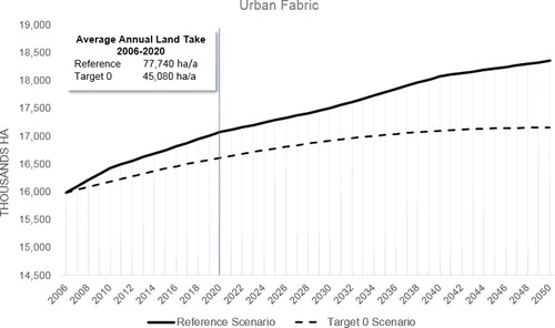
In 2006, the urban fabric and ICS land accounted for approximately 16,000 and 3,100 thousand hectares, respectively ( and ). Under the Reference scenario, the population growth will trigger an expansion of the urban fabric surface to approximately 17,000 thousand hectares by 2020, which corresponds to an average land take of 77,740 ha per year between 2006 and 2020 in Europe. In order to achieve the 2020 land-take milestone there is a need to reduce this European average to 45,080 ha by 2020, hence 42% less than the AALT of the Reference scenario for the same period ().
Figure 2. Estimated urban fabric areas following the Reference scenario (continuous line) and the areas based on the 2020 land-take milestone (dashed line), in the EU-27 between 2006 and 2050; the blue line highlights the year 2020 which corresponds to the milestone proposed in the RERM.
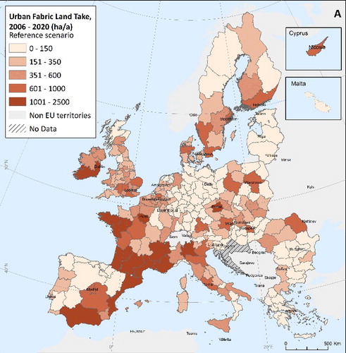
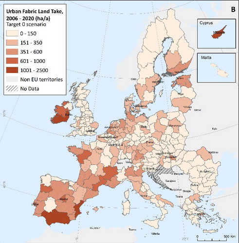
The spatial distribution of the urban fabric land-take indicator for the Reference scenario shows the highest potential impact for Ireland, the northern part of France, and the Southern and Eastern part of Spain, with NUTS 2 regions above 1,000 ha of annual land take (Map A in ). Map B on shows a general decline in the land take across the EU-27 regions if the 2020 milestone is implemented. Still, the land take will be particularly high in Ireland and the Southern part of Spain.
Figure 3. Urban Fabric Average Annual land Take between 2006 and 2020, Reference scenario (Map A) and Target 0 scenario (Map B).
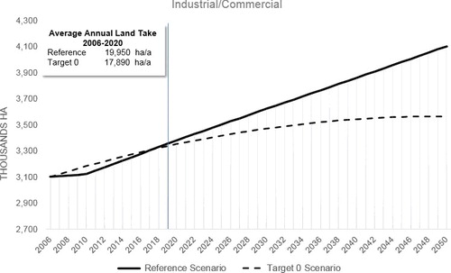
The ICS areas are expected to undergo changes as well, stimulated by an increase in the industrial, commercial and services economy. These areas are predicted to show a slight increase up to 3,400 thousand hectares by 2020, which corresponds to an AALT of 19,950 ha per annum. Despite the fact that this average was already below the average in 2006, the ICS AALT should reduce even more to an average of 17,890 ha by 2020 to reach the milestone, less than 10% compared to the Reference scenario ().
Figure 4. Estimated ICS areas following the Reference scenario (continuous line) and the areas based on the ‘no net land take in 2050’ (dashed line), in the EU-27 between 2006 and 2050.; the blue line highlights the year 2020 which corresponds to the milestone proposed in the RERM.
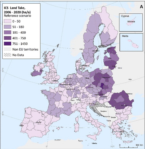
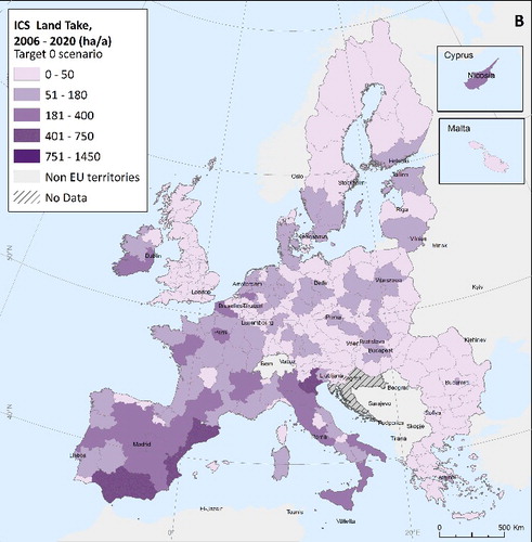
According to the model results, the ICS land-take pattern at regional level is rather different between both scenarios (). In the Reference scenario, more than 30% of the European regions are expected to have, on average, zero land take by 2020 and around 90% of the regions foresee less than 200 ha/annum of industrial land take. The highest average of ICS land take occurs in the regions located in the Eastern part of Europe, in particular Poland and Romania (Map A, ). In contrast, in the Target 0 scenario, the share of the industrial areas in the EU-27 is higher relative to the Reference scenario (Map B, ). In this scenario the future land take is influenced by the historical industrial land take. Therefore Belgium, Slovakia, Italy and Luxemburg presented the highest industrial land take.
Figure 5. Industrial/Commercial/Services (ICS) Average Annual Land Take between 2006 and 2020, Reference scenario (Map A) and Target 0 scenario (Map B).
3.1.2. Is it feasible to reach the milestone or is this an unrealistic goal?
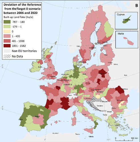
In the EU-27, under the Reference scenario, the average built-up land take between 2006 and 2020 is approximately 97,690 ha/annum. In order to reach the 2020 land-take milestone, the average land taken by built-up areas by 2020 should be approximately 62,970 ha/annum. The majority of the regions expect a higher built-up land take in the Reference scenario than in the Target 0 scenario. The regions that are more distant to the 2020 land-take milestone (dark red hues on ) are mostly situated in France, Poland and Bulgaria. The results show that Rhone Alpes, Alpes Core Azur, Ille de France and Aquitaine in France diverge from the 2020 land-take milestone, with more than 1,400 ha/a in the Reference Scenario than the Target 0 (). In these regions, the 2020 land-take milestone appears to be too ambitious and would require considerable efforts to be achieved, according to the assumptions made in the simulated scenarios. In the regions that are compliant with the Target 0 (green hues on ) it suggests that the 2020 milestone values would be reached even without any further action with values in the Reference scenario below the ones required to reach the no net land-take objective. In regions for which the expected development levels are below the 2020 land-take milestone, the policy could give a ‘misleading message’ – that these regions could increase the land take, and thus relax their land-use intensities.
Figure 6. Deviation of the Reference scenario from the Target 0 scenario. In Map B the Target 0 is the benchmark from the Reference scenario; red hues show a greater deviation from this target; green hues indicate that this target is on track.
3.2. Land-use intensity
3.2.1. Will the 2020 land-take milestone improve land-use intensity in Europe?
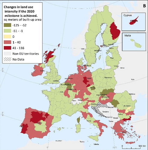
In 2006, the available built-up area per person in EU-27 was, on average, 437 m2. If the 2020 land-take milestone is implemented, the land-use intensity should decline compared with the baseline year but still, the impact will be lower compared with the Reference scenario (443 m2 / person in the Target 0 and 452 m2 / person in the Reference scenario).
At regional level, the implementation of the land-take measure will yield an increase in the land-use intensity in Europe (green hues on ). However, in few regions the milestone might have an inverse effect on the land-use intensity, in particular in Cyprus, Alentejo in Portugal, Castilla y Leon and Navarra in Spain, Ita Suomi in Finland, among other regions (dark red hues on ).
Figure 7. Built-up areas per person (m2/pp) in 2006 (Map A) and comparison between the Reference and Target 0 scenarios in 2020.
3.2.2. Will the land-use intensity trend change over time?
contrasts the population growth (x-axis) and the built-up growth (y-axis) in the Reference Scenario between 2006 and 2020. According to the projected population data between 2006 and 2020, Europe will diverge in terms of population growth with a positive population growth in the majority of the Member States, excluding Germany, Latvia, Lithuania, Romania, Estonia, and Hungary. The projected population decline in most of Germany, for instance, is primarily due to negative natural growth, with immigration levels insufficient to balance population decline. In Romania and Bulgaria, on the other hand, emigration contributes to further overall population decline. However, international migration flow projections are highly uncertain due to their high volatility over time and space. For what concerns most of the other parts of Europe, overall population growth is expected to be positive. The line splits the countries into three groups of land-use intensity trends () in Europe. The countries placed below the line are the ones where the population growth exceeds growth in built-up areas (green hues on ). These countries use the built-up areas more efficiently since the predicted amount of land consumed per capita will decrease over the period of analysis. The countries that follow this trend are Greece, Finland, Italy, United Kingdom, Italy, France, Slovenia, Sweden and Luxemburg. The countries with declining trends in land-use intensity can be distinguished in two different profiles. Countries such as Bulgaria, Germany, Estonia, Hungary, Latvia, Lithuania and Romania are losing population (left side of y-axis) while the growth of built-up area remains positive (dark red hues on ), i.e. the area consumed by each resident is increasing. The remaining countries fit in the third profile, where the population is expected to have a positive growth, but the amount of built-up areas is growing faster than the population (light red on , i.e. the use of land will be less efficient.
Figure 8. Percentage growth of population (x-axis) vs. percentage growth of built-up (y-axis) between 2006 and 2020 at Member State level. Line splits the countries into three different groups of land-use intensity trends in Europe: [1] Countries below the line (green hues) foresee faster population growth than built-up areas; [2] Countries above the line (light red hues) foresee faster built-up growth than population growth. [3] Countries on the right side of the x-axis expect built-up growth and population decline (dark red hues).
![Figure 8. Percentage growth of population (x-axis) vs. percentage growth of built-up (y-axis) between 2006 and 2020 at Member State level. Line splits the countries into three different groups of land-use intensity trends in Europe: [1] Countries below the line (green hues) foresee faster population growth than built-up areas; [2] Countries above the line (light red hues) foresee faster built-up growth than population growth. [3] Countries on the right side of the x-axis expect built-up growth and population decline (dark red hues).](/cms/asset/4336cd4b-1173-4621-9284-febe6239f3e1/cjep_a_1221801_f0008_oc.jpg)
3.3. Impact on other land uses
3.3.1. What is the impact of the 2020 land-take milestone on other land uses?
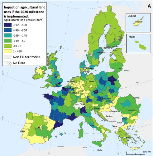
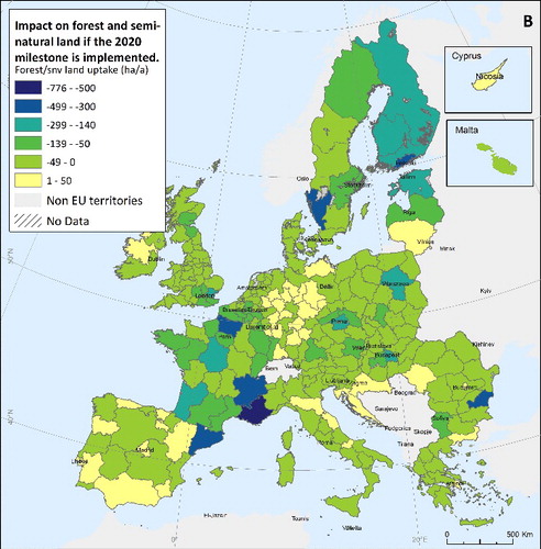
The highest impact of land take is expected to occur in arable land (between 70% and 74%). Pastures and forest, surrounding the urbanised areas, are also taken for built-up areas (between 12% and 15%). In most regions, the impact of new built-up area on other land uses will be reduced if the 2020 milestone is implemented (green and blue hues on . The reduction in the impact of built-up areas on agriculture is especially important in urban areas located in Mazowieckie, Lombardia, Prague, London and in the Southern part of France. For these regions, the quantified impact takes negative values corresponding to a decrease in the agricultural land taken by built-up areas when the Target 0 is implemented (green and blue hues Map A on ). Conversely, in some regions, the implementation of the Target 0 might cause larger losses of agricultural/pastures and forest/ semi-natural vegetation (in yellow). For example, in the southern part Portugal and Spain the amount of land taken by built-up areas in the Reference scenario is smaller than in the Target 0.
Figure 9. Changes in agricultural/ pastures (Map A), forest/semi-natural vegetation (Map B) AALT by built-up area between 2006 and 2020, according to the Reference and the Target 0 scenario. Negative values refer to the agricultural (Map A) or forest (Map B) land taken according to the Reference scenario that is preserved in the Target 0 scenario (green and blue hues), whereas positive values (in yellow) correspond to the additional land take for new building if the ‘no net land take milestone’ is implemented.
4. Discussion
Ex-ante impact assessment of scenarios/policies can particularly benefit from the integration of specialised models like economy, agriculture and forestry. The LUISA platform ensures an integrated modelling approach to project two land-take scenarios and to test the feasibility of reaching the 2020 land-take milestone proposed in the RERM. The design of this methodology follows two land-take scenarios: (Equation1(1) ) a reference scenario where the built-up areas follow a business-as-usual trend, including the current legislation as defined and used in the Energy Roadmap 2020, (Equation2
(2) ) an alternative policy scenario where the future land take in Europe is on track to reach the 2020 land-take milestone as proposed in the RERM, while keeping the same policies currently implemented. Importantly, the method allows translating a descriptive milestone as ‘no net land take by 2050’ into specific targets at different scales, while still keeping the full continental coverage. This is an important gain relative to observing the feasibility of achieving the 2020 land-take milestone at regional level and computes indicators to assess the impact of the policy measure on land-use intensity and the impact on other land uses.
The Resource Efficiency Roadmap calls for establishing thematic indicators to measure the performance of the 2020 land-take milestone. Our methodology can contribute to the assessment of the RERM which aims to improve the efficiency of land use in Europe. This approach was developed for assessing the level of effort needed in the EU in order to reach the 2020 land-take milestone set out in the Resource Efficiency Roadmap. The AALT is the indicator used to track progress towards the intermediate target: the 2020 land-take milestone. Based on the trend of the AALT under both scenarios, we conclude that only the Target 0 scenario delivers the goal that each region needs to achieve towards a more land-efficient Europe. For example, we have seen that the implementation of the 2020 land-take milestone in the EU-27 will trigger a reduction in the AALT between 2006 and 2020 from 976 km2 in the Reference scenario to 630 km2 in the Target 0. This is an important advantage since it gives us a perspective of the efforts required by each region to achieve the 2020 land-take milestone.
The methodology also allows the disaggregation of the 2020 land-take milestone at member state and regional level. Therefore, it can contribute to setting up compatible and harmonised European, national and regional approaches to measure the performance of the 2020 land-take milestone. Such spatial representations provide decision makers with clear suggestions on which are the possible areas that policies should target in order to deal with land-taking processes (Zoppi and Lai Citation2014). For example, shows that the majority of the EU NUTS 2 regions are unlikely to achieve the 2020 land-take milestone if stringent policy instruments are not implemented.
Naturally, the approach has its limitations too. All modelling exercises have a certain degree of uncertainty associated with them, largely caused by data limitations (Overmars et al. Citation2013). The integrated modelling framework presented here comprises a model configuration adapted to the European context. This means that LUISA has been configured with parameters and data adjusted to the European demographic changes, economic development and policies in place. In order to extrapolate this methodology to the non-EU-27 territory, the modelling framework, parameters and data inputs must be adapted to the purpose of the case study.
The results of the land-take indicator only partially reflect the drivers responsible for the land take. For instance, the infrastructures are not modelled in the model and are, thus, not included in the land-take indicator. This limitation might be overcome if additional data on demand for future planned infrastructures are available. This type of data is not available at European scale. For possible integration of the infrastructures in the assessment, a more detailed analysis at regional or local scale would be required. The results should be interpreted with caution because in the way the Target 0 Scenario was defined, following the RERM, the amount of land claimed for urban and ICS was estimated by drawing a linear interpolation between two known points. The first point is the observed land take in 2006; the second point is the zero land take in 2050. First, the linear interpolation triggers situations in which countries with a large growth in the past can maintain large AALT in the future for the Target 0 Scenario. Therefore, countries like Spain and France, with the largest AALT in the past, will be the countries with the largest AALT in the future, even when implementing the 2020 land-take milestone. However, those countries show opposed behaviour mainly because of two reasons: first, in Spain the Reference scenario foresees a lower amount of AALT due to future economic growth and population projections. As a consequence, the AALT in the Target 0 is higher. Second, although in both countries the population is expected to increase by around 10%, the built-up area per capita in France is practically twice that of Spain. It means that this last country has greater land-use intensity, following a more positive trend and giving rise to a weaker relationship between the population increase and the urban fabric uptake than in France. For this reason, we have seen the importance of using an indicator on land-use intensity which contrasts the amount of built-up area according to both scenarios with the population projections. Second, in this study even when using the CLC_r 2006, only land-use changes of up to 5 ha were considered. So, for countries with a small surface area and in particular, Malta and Luxembourg, there might be an underestimation of the land take, since in these countries changes might occur in patches smaller than 5 ha. Although these changes can be very important for the overall land take at the national level, it was not possible to account for them.
The various built-up land-use types have their own development dynamics (Kasanko et al. Citation2006). Our method also allows the detection of the different dynamics of urban development in Europe. Our results showed that dominant land uptake in Europe is the urban fabric (i.e. housing services and recreation) with the exception of the emerging and developing regions and in the southern and central European regions where ICS activities are the main driver of the built-up land take. However, as explained by Kasanko et al. (Citation2006) in cities where mixed residential/commercial land use is the prevailing type of commercial services the amount of land classified under commercial land use is, to some extent, underestimated. Hence, using the CLC 2000 and 2006 as a basis to estimate the future land take in the Target 0 scenario might underestimate the amount of industrial land as well.
Europe's intense urbanisation has a direct impact on its capability to produce food (Gardi 2013) and on the extent of green infrastructure and its associated ecosystem services (Maes et al. Citation2014). Aside the regional disaggregation, as explained in Section 2.3, the built-up areas and other land uses are spatially distributed. Importantly, the allocation model takes into account several aspects that determine land take, such as socio-economic and demographic trends, the competition with crops for food and energy and forestry, the current EU spatial legislation, the physical suitability, and constraints in the allocation of the built-up areas.
As suggested by Zoppi and Lai (Citation2014), future research should also relate to the construction of a spatial data infrastructure to monitor and control land-taking processes, with a view to the objective of no net land take by 2050. Member state targets set in national planning strategies are particularly relevant to control development of built-up areas in national targets. In order to support Member States in the definition of their own land-take targets and in reflection about the subsidiarity principle, a major improvement would require the use of the country-oriented targets as a specific goal. The proposed methodology could be enriched by comparing different scenarios for allocation of land take across Europe based on Member States' land-take targets. In Germany, for instance, a national target was set to reduce the land take from 100 to 30 hectares per day valid until 2020 (BIO by Deloitte Citation2014). Future application of this approach shall serve first to disaggregate this target at regional level, or even at pixel resolution, to assess the environmental consequences of the target. Another possible application could be the computation of a more robust indicator that measures the urban sprawl in Europe: Weighted Urban Proliferation (WUP) (Jaeger and Schwick Citation2014). This indicator is a combination of built-up area, its dispersion, and its utilisation density. This method was demonstrated to be more suitable than previous methods to quantify the indicator ‘urban sprawl’ in monitoring systems.
5. Conclusions
This work aimed to measure the impacts of the 2020 land-take milestone proposed in the RERM in EU-27. The modelling framework used allows implementation of the policy measure proposed in the RERM for land and assessment of its feasibility by 2020. The method allows also us to explore the future built-up area development according to different land-take scenarios, while taking into account the land-use impacts of agricultural and forestry development in Europe. We have seen that, in Europe, the land take is primarily driven by the continued expansion of residential and associated areas. The majority of the regions in EU-27 are expected to exhibit a higher land take in the Reference scenario than in the Target 0 scenario. It follows that those regions will need to adopt stronger policies to slow down the land uptake so as to achieve the 2020 land-take milestone. Furthermore, the land-use intensity in Europe is consequently expected to increase with the implementation of the 2020 land-take milestone but still the amount of land consumed per inhabitant will be higher compared with the baseline year and the built-up area will, on average grow faster than the population. Our results also showed higher impact on other land uses, in particular in the agricultural land, in the Reference scenario than in the Target 0 scenario. We conclude that the implementation of the 2020 land-take milestone, by reducing future land take in Europe, increases the efficient use of land. However, in some regions, the expected development levels are below the 2020 land-take milestone, giving the misleading message that these regions could still increase the land take and consequently relax their land-use intensity. Under this circumstance, additional measures are recommended by the competent authority to further reduce the land take. In this case, the decision maker should further investigate if the region is on track to reach the 2020 milestone due to an overestimation of the land take considering the high value in the past, or if it is due to a stagnation/ decline of the population foreseen in the region. In the first case, redesigning the target might be required using other data sources (for example, Land Use and Coverage Area frame Survey (LUCAS) or regional statistics on land). If the population projection shows stagnation/ declining then the land take for the Reference scenario could be used for this purpose.
A detailed impact assessment at regional level would be relevant to include appropriate spatial planning policies and recommendations. This requires further improvement to the land-take scenario including more detailed data.
Acknowledgements
The work herein presented is executed with the support of the Administrative Arrangement between DG ENV and JRC on “Support for improving land-use modelling for informing environmental policy making.”
Disclosure statement
No potential conflict of interest was reported by the authors.
Additional information
Funding
References
- Baranzelli, Claudia, Ine Vandecasteele, Ricardo Ribeiro Barranco, Ines Mari i Rivero, Nathan Pelletier, Okke Batelaan, and Carlo Lavalle. 2015. “Scenarios for Shale Gas Development and Their Related Land Use Impacts in the Baltic Basin, Northern Poland.” Energy Policy 84: 80–95. doi:10.1016/j.enpol.2015.04.032.
- Batista E Silva, Filipe, Eric Koomen, Vasco Diogo, and Carlo Lavalle. 2014. “Estimating Demand for Industrial and Commercial Land Use Given Economic Forecasts.” PloS One 9 (3): e91991. doi:10.1371/journal.pone.0091991.
- Batista e Silva, Filipe, Carlo Lavalle, Chris Jacobs-Crisioni, Ricardo Barranco, Grazia Zulian, Joachim Maes, Claudia Baranzelli, et al. 2013. “Direct and Indirect Land Use Impacts of the EU Cohesion Policy Assessment with the Land Use Modelling Platform” EUR 26460. Luxembourg: Publications Office of the European Union. doi:10.2788/60631.
- Batista e Silva, Filipe, Carlo Lavalle, and Eric Koomen. 2013. “A Procedure to Obtain a Refined European Land Use/Cover Map.” Journal of Land Use Science 8 (3): 255–83. doi:10.1080/1747423X.2012.667450.
- BIO by Deloitte. 2014. Study Supporting Potential Land Targets Under the 2014 Land Communication. Report prepared for the European Commission, DG Environment in collaboration with AMEC, IVM and WU. Brussels: European Commission.
- Britz, W., and P. Witzke. 2014. CAPRI Model Documentation 2014 : Table of Contents. http://www.capri-model.org/dokuwiki/doku.php?id=capri:capri_pub#pap.
- Byron, Helen J. 2000. Biodiversity and Environmental Impact Assessment: A Good Practice Guide for Biodiversity and Environmental Impact Assessment : A Good Practice Guide. Sandy, UK: The RSPB, WWF-UK, English Nature and the Wildlife Trusts.
- Byron, Helen J., Joanna R. Treweek, William R. Sheate, and Stewart Thompson. 2000. “Road Developments in the UK: An Analysis of Ecological Assessment in Environmental Impact Statements Produced Between 1993 and 1997.” Journal of Environmental Planning and Management 43: 71–97. doi:10.1080/09640560010775.
- Ceccarelli, T., S. Bajocco, L. Luigi Perini, and Luca Salvati. 2014. “Urbanisation and Land Take of High Quality Agricultural Soils: Exploring Long-Term Land Use Changes and Land Capability in Northern Italy.” International Journal of Environmental Research 8: 181–192.
- Decoville, Antoine, and Marc Schneider. 2015. “Can the 2050 Zero Land Take Objective of the EU Be Reliably Monitored? A Comparative Study.” Journal of Land Use Science 11 (3). Taylor & Francis: 1–19. doi:10.1080/1747423X.2014.994567.
- E3MLAB. 2010. General Equilibrium Model for Economy – Energy – Environment – GEM-E3 MODEL MANUAL. Athens: E3MLAB.
- European Environment Agency. 2015. The European Environment: State and Outlook 2015: Synthesis Report. Copenhagen: EEA. doi:10.2800/944899.
- European Commission. 1999. ESDP – European Spatial Development Perspective: Towards a Balanced and Sustainable Development of the Union Territory. Luxemburg. http://eur-lex.europa.eu/legal-content/EN/TXT/HTML/?uri=URISERV:g24401&from=EN.
- European Commission. 2010. Communication From the Commission EUROPE 2020 A Strategy for Smart, Sustainable and Inclusive Growth. Com(2010) 2020. Brussels: Commission of the European Communities. doi:10.1016/j.resconrec.2010.03.010.
- European Commission. 2011a. “COM (2011) 571 – Roadmap to a Resource Efficient Europe. European Commission, Documentation and Data. Brussels: European Commission. http://ec.europa.eu/environment/resource_efficiency/pdf/com2011_571.pdf.
- European Commission. 2011b. Analysis Associated with the Roadmap to a Resource Efficient Europe Part II. European Commission Staff Working Paper Document SEC (2011) 527. Brussels: European Commission.
- European Commission. 2011c. Impact assessment accompanying the Energy Roadmap 2050. European Commission Staff Working Paper Document SEC(2011)1566. Brussels: European Commission.
- European Commission/DG Economic and Financial Affairs. 2011. The 2012 Ageing Report: Underlying Assumptions and Projection Methodologies. Brussels: European Commission.
- European Environment Agency. 2004. Land Take: European Environment Agency (EEA). http://www.eea.europa.eu/data-and-maps/indicators/land-take.
- European Environment Agency. 2013. Corine Land Cover 2000-2006 Changes: European Environment Agency (EEA). http://www.eea.europa.eu/data-and-maps/data/corine-land-cover-2000.
- Gardi, Ciro, Panos Panagosa, Marc van Liedekerkea, Claudio Boscob, and Delphine de Brogniez. 2015. “Land Take and Food Security: Assessment of Land Take on the Agricultural Production in Europe.” Journal of Environmental Planning and Management 58 (5): 898–912.
- Geneletti, Davide. 2006. “Some Common Shortcomings in the Treatment of Impacts of Linear Infrastructures on Natural Habitat.” Environmental Impact Assessment Review 26: 257–67. doi:10.1016/j.eiar.2005.10.003.
- Gusti, M, and G Kindermann. 2011. “An Approach to Modeling Landuse Change and Forest Management on a Global Scale.” In SIMULTECH-2011. Proceedings of 1st International Conference on Simulation and Modeling Methodologies, Technologies and Applications, edited by Janusz Kacprzyk, Nuno Pina, and Joaquim Filipe, 180–85. Lisbon: SciTePress - Science and Technology Publications, Portugal. http://www.scopus.com/inward/record.url?eid=2-s2.0-80052562004&partnerID=40&md5=d1fca2c3f8700fac0c85a958a48547d8.
- Hilferink, Maarten, and Piet Rietveld. 1999. “LAND USE SCANNER: An Integrated GIS Based Model for Long Term Projections of Land Use in Urban and Rural Areas.” Journal of Geographical Systems 1 (2): 155–177. doi:10.1007/s101090050010.
- Huang, Jingnan, X.X. Lu, and Jefferey M. Sellers. 2007. “A Global Comparative Analysis of Urban Form: Applying Spatial Metrics and Remote Sensing.” Landscape and Urban Planning 82 (4): 184–197. doi:10.1016/j.landurbplan.2007.02.010.
- Hutyra, Lucy R., Byungman Yoon, Jeffrey Hepinstall-Cymerman, and Marina Alberti. 2011. “Carbon Consequences of Land Cover Change and Expansion of Urban Lands: A Case Study in the Seattle Metropolitan Region.” Landscape and Urban Planning 103 (1): 83–93. doi:10.1016/j.landurbplan.2011.06.004.
- Jacobs-Crisioni, Chris, Filipe Batista e Silva, Carlo Lavalle, Claudia Baranzelli, Ana Barbosa, and Carolina Perpiña Castillo. 2016. “Accessibility and Territorial Cohesion in a Case of Transport Infrastructure Improvements with Changing Population Distributions.” European Transport Research Review 8 (9). doi:10.1007/s12544-016-0197-5.
- Jaeger, Jochen A G, Hans Georg Schwarz-von Raumer, Heide Esswien, Manfred Müller, and Manfred Schmidt-Lüttman. 2007. “Time Series of Landscape Fragmentation Caused by Transportation Infrastructure and Urban Development: A Case Study from Baden-Württemberg, Germany.” Ecology and Society 12 (1): 22. http://www.ecologyandsociety.org/vol12/iss1/art22/
- Jaeger, Jochen A.G., and Christian Schwick. 2014. “Improving the Measurement of Urban Sprawl: Weighted Urban Proliferation (WUP) and Its Application to Switzerland.” Ecological Indicators 38 (March): 294–308. doi:10.1016/j.ecolind.2013.11.022.
- Jiang, Li, Xiangzheng Deng, and Karen C. Seto. 2013. “The Impact of Urban Expansion on Agricultural Land Use Intensity in China.” Land Use Policy 35: 33–39. doi:10.1016/j.landusepol.2013.04.011.
- Kasanko, Marjo, José I. Barredo, Carlo Lavalle, Niall McCormick, Luca Demicheli, Valentina Sagris, and Arne Brezger. 2006. “Are European Cities Becoming Dispersed?. A Comparative Analysis of 15 European Urban Areas.” Landscape and Urban Planning 77: 111–130. doi:10.1016/j.landurbplan.2005.02.003.
- Kindermann, Georg E, Michael Obersteiner, Ewald Rametsteiner, and Ian McCallum. 2006. “Predicting the Deforestation-Trend Under Different Carbon-Prices.” Carbon Balance and Management 1 (1): 1–15. doi:10.1186/1750-0680-1-15.
- Koomen, Eric, Piet Rietveld, and Ton Nijs. 2007. “Modelling Land-Use Change for Spatial Planning Support.” The Annals of Regional Science 42 (1): 1–10. doi:10.1007/s00168-007-0155-1.
- Lavalle, Carlo, Claudia Baranzelli, Filipe Batista E Silva, Sarah Mubareka, Carla Rocha Gomes, Eric Koomen, and Maarten Hilferink. 2011. “A High Resolution Land Use/Cover Modelling Framework for Europe: Introducing the EU-ClueScanner100 Model.” In Lecture Notes in Computer Science (Including Subseries Lecture Notes in Artificial Intelligence and Lecture Notes in Bioinformatics), 6782 LNCS:60–75. doi:10.1007/978-3-642-21928-3_5.
- Lavalle, Carlo, Sarah Mubareka, Carolina Perpiña Castillo, Christiaan Jacobs-Crisioni, Claudia Baranzelli, Filipe Batista, and Ine Vandecasteele. 2013. Configuration of a Reference Scenario for the Land Use Modelling Platform. Luxembourg: Publications Office of the European Union. doi:10.2788/58826.
- Maes, Joachim, Ana Barbosa, Claudia Baranzelli, Grazia Zulian, Filipe Batista e Silva, Ine Vandecasteele, Roland Hiederer, et al. 2014. “More Green Infrastructure Is Required to Maintain Ecosystem Services under Current Trends in Land-Use Change in Europe.” Landscape Ecology 30 (3): 517–34. doi:10.1007/s10980-014-0083-2.
- Mubareka, Sarah, Christine Estreguil, Claudia Baranzelli, Carla Rocha Gomes, Carlo Lavalle, and Barbara Hofer. 2013. “A Land-Use-Based Modelling Chain to Assess the Impacts of Natural Water Retention Measures on Europe's Green Infrastructure.” International Journal of Geographical Information Science 27 (9): 1740–1763. doi:10.1080/13658816.2013.782408.
- Mubareka, Sarah, Eric Koomen, Christine Estreguil, and Carlo Lavalle. 2011. “Development of a Composite Index of Urban Compactness for Land Use Modelling Applications.” Landscape and Urban Planning 103 (3–4): 303–317. doi:10.1016/j.landurbplan.2011.08.012.
- Nicholson, Emily, Ben Collen, Alberto Barausse, Julia L. Blanchard, Brendan T. Costelloe, Kathryn M.E. Sullivan, Fiona M. Underwood, et al. 2012. “Making Robust Policy Decisions Using Global Biodiversity Indicators.” PLoS ONE 7 (7):e41128. doi:10.1371/journal.pone.0041128.
- Overmars, Koen P, John Helming, Henk van Zeijts, Torbjörn Jansson, and Ida Terluin. 2013. “A Modelling Approach for the Assessment of the Effects of Common Agricultural Policy Measures on Farmland Biodiversity in the EU27.” Journal of Environmental Management 126 (September): 132–141. doi:10.1016/j.jenvman.2013.04.008.
- Salvati, Luca. 2014. “Land Availability vs Conversion by Use Type: A New Approach for Land Take Monitoring.” Ecological Indicators 36: 221–223. doi:10.1016/j.ecolind.2013.07.004.
- Tittensor, D.P., M. Walpole, S.L.L. Hill, D.G. Boyce, G.L. Britten, N.D. Burgess, S.H.M. Butchart, et al. 2014. “A Mid-Term Analysis of Progress Toward International Biodiversity Targets.” Science 346 (6206): 241–244. doi:10.1126/science.1257484.
- Tóth, Gergely. 2012. “Impact of Land-Take on the Land Resource Base for Crop Production in the European Union.” Science of the Total Environment 435–436: 202–214. doi:10.1016/j.scitotenv.2012.06.103.
- Tratalos, Jamie, Richard A. Fuller, Karl L. Evans, Richard G. Davies, Stuart E. Newson, J.J.D. Greenwood, and Kevin J. Gaston. 2007. “Bird Densities Are Associated With Household Densities.” Global Change Biology 13: 1685–1695. doi:10.1111/j.1365-2486.2007.01390.x.
- United Nations, Department of Economic and Social Affairs, Population Division. 2014. World Urbanization Prospects: The 2014 Revision. Vol. ST/ESA/SER. New York: United Nations. doi:10.4054/DemRes.2005.12.9.
- Verburg, Peter H., and Koen P. Overmars. 2009. “Combining Top-Down and Bottom-Up Dynamics in Land Use Modeling: Exploring the Future of Abandoned Farmlands in Europe with the Dyna-CLUE Model.” Landscape Ecology 24 (9): 1167–1181. doi:10.1007/s10980-009-9355-7.
- Xiao, Jieying, Yanjun Shen, Jingfeng Ge, Ryutaro Tateishi, Changyuan Tang, Yanqing Liang, and Zhiying Huang. 2006. “Evaluating Urban Expansion and Land Use Change in Shijiazhuang, China, by Using GIS and Remote Sensing.” Landscape and Urban Planning 75 (1–2): 69–80. doi:10.1016/j.landurbplan.2004.12.005.
- Zoppi, Corrado, and Sabrina Lai. 2014. “Land-Taking Processes: An Interpretive Study Concerning an Italian Region.” Land Use Policy 36: 369–380. doi:10.1016/j.landusepol.2013.09.011.
Appendix
Table A1. LUISA land-use categories grouped at level 1 (first column), level 2 (second column); land-use classification in Corine Land Cover (CLC) (third column); name of the land-use categories in CLC (fourth column); modelled classes (fifth column); inclusion of these land-use categories in the estimation of the future land take (yes/no and from/to) (e.g. from permanent crops to urban).