Abstract
Eocene-Oligocene paleogeographic/paleotectonic reconstructions of the Rhodopian – northern Aegean – western Black Sea region largely ignore the Thrace Basin, a large sedimentary basin up to 9 km thick that has been long interpreted as a forearc basin developed in a context of northward subduction. Recent structural, stratigraphic, petrologic, and sedimentologic data challenge this notion and may instead be interpreted within a context of upper-plate extension during the complex transition between the collisional tectonic regime related to the closure of Vardar-İzmir-Ankara oceanic realm and the extensional regime characterizing the Oligocene-Neogene evolution of the Aegean and peri-Aegean regions. The detritus filling the Thrace Basin was derived from two main sediment source areas: (i) the mostly metamorphic terrains of the Rhodopes to the west and (ii) the Vardar-İzmir-Ankara and Biga (intra-Pontide?) subduction-accretion prisms to the southwest. During most of the Eocene-Oligocene, the entire basin was characterized by a complex physiography, as shown by commercial seismic lines in the subsurface and abrupt lateral facies change at the surface. Such physiography was controlled by a series of basement highs trending from WNW-ESE (in the eastern and northern portions of the basin) to WSW-ENE (in the western and southern portions of the basin) which influenced sediment dispersal and the areal distribution of paleoenvironments.
1. Introduction
The Thrace Basin is an important hydrocarbon province covering an area in excess of 15,000 km2 in Turkey, Greece, and Bulgaria. The complex historical vicissitudes of the region have made collaboration among the researchers of the three countries difficult. Consequently, unified geological analyses and interpretations of the Thrace Basin are still missing despite the great wealth of outcrop and subsurface data available from both academic and industrial sources. Integration of such data with new stratigraphic, sedimentologic, petrologic, and radiometric data provides a unique opportunity to delineate the sediment dispersal system of the entire Thrace Basin and to generate new constraints on the general evolutionary trends of the basin. This paper illustrates how detailed definition of sandstone detrital modes (including heavy mineral analysis) and its integration with palaeocurrent analysis and sedimentological facies relationships can pinpoint significant within-basin provenance variations, thus providing important elements to constrain in detail (i) the sediment dispersal pattern, (ii) the three-dimensional geometry of petrographic lithosomes, and (iii) the overall basin evolution. The sediment paleodispersal system of the entire Thrace Basin is here considered for the first time. Recent studies have constrained the palaeoenvironmental/palaeostructural setting and the chronostratigraphy of the southern portion of the basin fill (d’Atri, Zuffa, Cavazza, Okay, & Di Vincenzo, Citation2012; Okay, Özcan, Cavazza, Okay, & Less, Citation2010; Özcan et al., Citation2010), thus integrating a large wealth of preexisting data, both from surface and subsurface studies (e.g. Doust & Arıkan, Citation1974; Görür & Okay, Citation1996; Okay, Tüysüz, & Kaya, Citation2004; Önal, Citation1986; Sümengen & Terlemez, Citation1991; Turgut & Eseller, Citation2000; Yaltırak & Alpar, Citation2002). Similarly, sandstone petrology/geochemistry and the overall paleogeographic evolution of the western margin of the basin in NE Greece and SW Bulgaria have been studied recently by Caracciolo, Critelli, Innocenti, Kolios, and Manetti (Citation2011, Citation2012) and Caracciolo et al. (Citation2012).
2. Background geological information
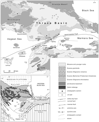
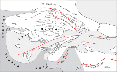
The Thrace Basin is a complex system of depocenters located between the Rhodope-Strandja Massif to the north and west and the Biga Peninsula to the south (Figure ). The southern margin of the basin is now covered by the Marmara and northern Aegean seas and deformed by the North Anatolian Fault system. The Thrace Basin is the largest and thickest Tertiary sedimentary basin of the eastern Balkan region and constitutes an important hydrocarbon province (Siyako & Huvaz, Citation2007; Turgut & Eseller, Citation2000; Turgut, Türkaslan, & Perinçek, Citation1991). The older part of the basin fill crops out along the basin margins, but it is covered by Plio-Quaternary deposits in the basin center (Siyako, Citation2006). In this area, subsurface data is abundant as Türkiye Petrolleri Anonim Ortaklığı has drilled more than 350 wells and acquired in the 1980s and 1990s a fairly dense network of seismic lines.
Figure 1. Schematic geological map of the Thrace and Marmara region (compiled from Andronopoulos, Citation1978; Konak, Citation2002; Maratos et al., 1977; Okay et al., Citation2010; Papadopoulos, Citation1980). The smaller box (lower left) shows the position of Thrace Basin with respect to main tectonic domains. Legend refers only to geological map.
Most of the Thrace Basin fill ranges from the Early Eocene (Ypresian) to the Late Oligocene. Maximum total thickness, including the Neogene-Quaternary succession, commonly reaches 5,000 m and goes up to 9,000 m in a narrow depocenter bound by strike-slip faults (Siyako & Huvaz, Citation2007; Turgut & Eseller, Citation2000; Yıldız, Toker, & Şengüler, Citation1997). In terms of volume, most of the Eocene-Oligocene sedimentary succession is made of basin-plain turbidites (Aksoy, Citation1987; Turgut et al., Citation1991). Sedimentation along the basin margins was characterized by carbonate deposits during the Eocene and by deltaic bodies prograding towards the basin center in the Oligocene (Cavazza, unpublished data; Sümengen & Terlemez, Citation1991; Sümengen, Terlemez, Şentürk, & Karaköse, Citation1987). The western margin of the basin, in Greek and Bulgarian territory, was characterized already in the Eocene by a series of coarse-grained fan-deltas prograding eastward and feeding the depocentral basin-plain turbidites (Caracciolo et al., Citation2011, Citation2012).
In the northeast and northwest, the basin sediments overlie nonconformably the metamorphic rocks of the Strandja and Rhodope massifs, respectively (Figure ). The southern boundary of the Thrace Basin is less well defined, with Eocene sedimentary and volcanic rocks extending southward into the Biga Peninsula, where they lie unconformably over the metamorphic rocks of the Sakarya Zone (Siyako, Bürkan, & Okay, Citation1989). In the south, the North Anatolian Fault system cuts and deforms the sedimentary rocks of the Thrace Basin. Small outcrops of ophiolitic rocks in this region have been interpreted as marking the Intra-Pontide suture between the Sakarya Zone and the Strandja-Rhodope massifs (Beccaletto, Bartolini, Martini, Hochuli, & Kozur, Citation2005; Okay & Tüysüz, Citation1999; Şengör & Yılmaz, Citation1981). The southwestern margin of the Thrace Basin is covered by the northern Aegean Sea but Eocene-Oligocene sedimentary successions correlatable with those of mainland Turkey and Greece crop out on several islands in the region. Those of the islands of Lemnos and Gökçeada were studied during this research and the results are included in this paper.
The Thrace Basin can be subdivided into four parts (Figure ): (1) Along the Strandja Massif to the northeast, there is a shelf region characterized by shallow-marine Eocene limestones passing southwestward into deeper marine limestones, marls, and turbidites. (2) In the basin center, most of the Eocene–Oligocene succession consists of siliciclastic rocks, up to 9000 m thick, as shown by a dense network of seismic sections and by hydrocarbon exploration wells (e.g. Siyako & Huvaz, Citation2007; Turgut et al., Citation1991). The majority of the Thrace Basin sedimentary fill accumulated in this area. (3) The southern portion of the basin in the Gelibolu peninsula is characterized by Eocene shallow-marine limestones overlain by turbidites comprising large olistoliths of ophiolite and coeval limestone (Okay et al., Citation2010; Saner, Citation1985). (4) To the west (NE Greece and SE Bulgaria), marginal fan-deltas, shelf deposits, and laterally equivalent deeper marine turbidites crop out extensively (Maratos, Andronopoulos, & Koukouzas, 1977; Papadopoulos, Citation1980), but the original basin margin geometries have been largely disrupted by extensive exhumation of the Rhodopian Massif during North Aegean extension (e.g. Krohe & Mposkos, Citation2002).
Contrasting hypotheses have been proposed to explain the origin and the evolution of the Thrace Basin: (1) Keskİn (Citation1984) and Perinçek (Citation1991) considered this basin as intramontane in nature. (2) Turgut et al. (Citation1991) and Tüysüz, Barka, and Yiğitbaş (Citation1998) suggested a transtensional post-collisional origin following the closure of the Intra-Pontide Ocean. (3) Görür and Okay (Citation1996) proposed a forearc location between a subduction-accretion complex to the south and a volcanic arc to the north. (4) Şen (Citation2002) championed a flexural origin due to the loading induced by backthrusts related to the İzmir-Ankara suture.
3. Plate-tectonic setting of the Thrace Basin
The Thrace Basin lies across a geodinamically complex area characterized by three juxtaposed lithospheric blocks (terranes) distinguishable as to lithology, structural configuration, and geological evolution: the Rhodope-Strandja crystalline massif, the İstanbul Zone, and the Sakarya Zone (Figure ). (1) The Rhodope-Strandja massif has Laurasian affinity and it is composed of Variscan continental crust, Mesozoic metasedimentary rocks, and fragments of oceanic crust (Burg et al., Citation1996). This assemblage suffered repeated phases of crustal thickening and exhumation during the Cretaceous and early Tertiary (e.g. Krohe & Mposkos, Citation2002). The main phase of deformation occurred in the Maastrichtian-early Paleogene following the closure of the Vardar Ocean (e.g. Stampfli & Borel, Citation2004). (2) Located at the southwestern margin of the Black Sea, the İstanbul Zone is a continental fragment about 400 km long and 70 km wide. It comprises a Precambrian crystalline basement and a fairly complete Ordovician-Carboniferous sedimentary cover which was deformed during the Variscan orogeny (Görür et al., Citation1997; Okay, Zack, Okay, & Barth, Citation2011). Its stratigraphic, palaeobiogeographic, and palaeomagnetic characters show a marked Laurasian affinity. It was proposed that this continental fragment rifted off the Odessa shelf and drifted southward during the opening of the western Black Sea backarc basin in the Cretaceous (Görür & Okay, Citation1996). (3) The Sakarya Zone, approximately 1,500 km long and 120 km wide, is a continental block separated from the Rhodope-Strandja crystalline massif and the İstanbul Zone by the so-called Intra-Pontide suture (Şengör & Yılmaz, Citation1981). The basement of this terrane is made of amphibolite-facies metamorphic rocks visible in a few tectonic windows of limited areal extent (e.g. Cavazza, Okay, & Zattin, Citation2009; Okay, Satır, Zattin, Cavazza, & Topuz, Citation2008). In the Paleogene, the Sakarya Zone collided with the Anatolide-Tauride terrane of African affinity to the south following the closure of the İzmir-Ankara ocean (Okay & Tüysüz, Citation1999; Stampfli & Borel, Citation2004).
Juxtaposition of the İstanbul and Sakarya Zones along the Intra-Pontide suture occurred in pre-Cenozoic time (Cavazza, Federici, Okay, & Zattin, Citation2012), although the exact timing has not been yet clearly defined. The westward continuation of the Intra-Pontide suture into the Marmara Sea is controversial. Scattered outcrops of the ophiolitic Çetmi mélange in the Biga peninsula have been interpreted as marking the Intra-Pontide suture between the Sakarya Zone to the southeast and terrains of Rhodopian affinity to the northwest (Beccaletto et al., Citation2005; Okay & Tüysüz, Citation1999; Şengör & Yılmaz, Citation1981; Siyako et al., Citation1989). Stampfli and Hochard (Citation2009) dated the formation of the suture in the Biga peninsula at 200–180 Ma (Late Triassic–Early Jurassic) despite the fact that the blocks and the matrix composing the mélange reach up to the Early Cretaceous (Beccaletto, Citation2004).
Juxtaposition of the Sakarya and Anatolide-Tauride terranes occurred between the Late Cretaceous and the Paleogene following the closure of the Vardar Ocean and its continuation to the east, the İzmir-Ankara ocean (Okay & Tüysüz, Citation1999; Stampfli & Hochard, Citation2009). The transition between the collisional tectonic regime following the closure of these oceanic realms and the extensional regime characterizing the Neogene evolution of the Aegean and peri-Aegean regions is complex and relatively poorly known (e.g. Bonev, Citation2006; Bonev & Beccaletto, Citation2007; Burchfiel, Nakov, Tzankov, & Royden, Citation2000). The Thrace Basin developed during this transitional tectonic regime.
4. Stratigraphy and structure of the Thrace Basin
4.1. Western Thrace Basin
Traditionally, the term Thrace Basin has been used with reference to the depocentral area in Turkish territory. Recently, Caracciolo et al. (Citation2011, Citation2012) and d’Atri et al. (Citation2012) demonstrated that the age-equivalent successions of Middle-Late Eocene and Oligocene sedimentary and volcaniclastic rocks cropping out extensively around the margins of the Rhodopes in SE Bulgaria and NE Greece belong to the same sediment paleodispersal system, and thus can be considered the western portion of the basin. Facies and paleocurrent analyses coupled with sandstone petrology indicate that large volumes of the sediment filling the Thrace Basin were derived from the erosion and progressive unroofing of the Rhodopes. Present-day outcrops are separated by outliers of Rhodopian basement rocks and are assigned for convenience to separate sub-basins (e.g. Caracciolo et al., 2011, 2012), although it is difficult to assess the role of Oligocene-Miocene exhumation in this fragmentation.
In NE Greece, Lutetian coarse-grained fan-delta deposits nonconformably overlie the basement rocks of the Rhodopes and grade upward into fluvial deposits and then into laterally equivalent facies, from lagoonal to inner shelf (Figure ). This lower siliciclastic succession is overlain – locally with a slight angular unconformity – by shallow-water nummulitic limestone of Late Lutetian age (Maratos et al., 1977). The remaining Eocene section is characterized by a general paleoenvironmental trend from shelf/slope deposits to the west to deeper-marine turbidites to the east (Caracciolo et al., Citation2011). In the Early Oligocene, the western Thrace Basin system underwent an increasingly complex tectonic and palaeoenvironmental evolution (Innocenti et al., Citation1984), possibly the result of the progressive exhumation/unroofing of the Rhodopes inducing higher local erosion rates and the progradation of coarse-grained clastic wedges from the basin margins. Latest Eocene and Early Oligocene sedimentation is marked by abundant volcaniclastic input ranging from pyroclastic flows to ash turbidites. Lava flows are also present.
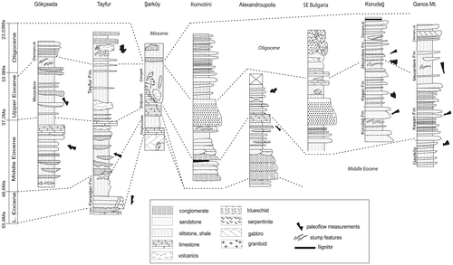
Figure 2. Stratigraphic sections and correlations in the studied areas. For section location, see Figure . Palaeoflow measurements are shown in each section. Geological timescale from Gradstein, Ogg, and Smith (Citation2004).
In SE Bulgaria, sedimentation began in the Late Eocene (Figure ) (Caracciolo et al., Citation2012). During the Priabonian, the Central-Eastern Rhodopes portion of the Thrace Basin experienced a marine transgression marked by a thickening-upward sandy-pelitic turbidite succession. At the end of the Priabonian, the depositional environment evolved into a continental–transitional–nearshore setting, represented by medium- to coarse-grained, carbonate-rich sandstones, alternating with microconglomerates. Similar to NE Greece, volcanic activity started in the latest Eocene. The structural signatures and the coarse-grained nature of sediments associated with the igneous activity suggest that extension occurred during and following magmatism. Volcanic activity and associated sedimentation along the volcanic belt ceased at the end of the Oligocene, although sedimentation continued locally until the early Miocene (Burchfiel et al., Citation2000).
4.2. Northern Thrace Basin
The northern margin of the Thrace Basin has been traditionally considered as the sediment source area for most of the basin fill (e.g. Büyükutku, Citation2005; Görür & Okay, Citation1996). This is at odds with the widespread presence of shallow-marine limestone onlapping the basement rocks of the Strandja Massif (Figure ). These limestones are time-transgressive, drape the northern margin, and cover the entire Late Eocene-earliest Oligocene time span (Less, Özcan, & Okay, Citation2011; Siyako, Citation2006): it is therefore unlikely that any significant terrigenous input to the Thrace Basin could have derived from its northern margin, at least during this time frame. Significant detrital input from the northern basin margin began only in the Late Oligocene (e.g. Turgut & Eseller, Citation2000) when an important phase of delta progradation occurred also along the southern margin.
4.3. Southern Thrace Basin
The sedimentary basin fill of the southern Thrace Basin crops out extensively in the Gelibolu peninsula and to the north of the Gulf of Saros (Figure ). Özcan et al. (Citation2010) and Okay et al. (Citation2010) have significantly refined the stratigraphy of this portion of the Thrace Basin. In the northern Aegean Sea, coeval sedimentary rocks crop out on the islands of Lemnos, Gökçeada, and Bozcaada, although the relationships between these and the age-equivalent deposits in mainland Turkey and Greece are difficult to establish.
The stratigraphy of the southern Thrace Basin is somewhat different north and south of the Ganos segment of the North Anatolian Fault (e.g. Doust & Arıkan, Citation1974; Siyako & Huvaz, Citation2007; Sümengen & Terlemez, Citation1991; Turgut et al., Citation1991). North of the Ganos Fault low-grade metamorphic rocks belonging to the circum-Rhodope belt are covered by a shallowing upward succession of Bartonian-Priabonian distal-to-proximal turbidites, overlain by shelfal, deltaic, and continental facies of Oligocene age (Okay et al., Citation2010). Conversely, south of the Ganos Fault a rather complex Eocene succession overlying the Çetmi mélange (Beccaletto et al., Citation2005; Okay et al., Citation2010; Okay, Siyako, & Bürkan, Citation1991) comprises thick olistostromes and large olistoliths derived from the mélange (Okay et al., Citation2010) and from penecontemporaneous limestone (Figure ).
The Çetmi mélange crops out in situ in the Biga Peninsula where it marks the suture between Rhodopian basement to the northwest and the Sakarya terrane to the southeast (Figure ). The mélange is intruded by a Lower Eocene (ca. 53 Ma) granodiorite and is unconformably overlain by Eocene rocks (Figure , Beccaletto, Bonev, Bosch, & Bruguier, Citation2007; Okay et al., Citation1991). The limestone blocks in the mélange range from Late Triassic to Cretaceous in age, the youngest blocks being Turonian–Coniacian (Okay et al., Citation1991). Following Okay et al. (Citation2010) we consider the outcrops of mélange north of the Dardanelles as derived from tectono-sedimentary reworking of the Çetmi mélange from the Biga peninsula. More generally, the entire Upper Eocene succession (Çengelli Fm) south of the Ganos Fault is characterized by an olistostromal, very coarse-grained turbidite series (Figure ). The clasts in the coarser mass flows include Eocene (Bartonian and Priabonian) neritic limestone, serpentinite, gabbro, basalt, metabasite, pelagic limestone, radiolarian chert, gabbro, greywacke-shale, and quartz-diorite. The source of the clasts in the mass flows was an ophiolitic mélange unconformably overlain by neritic Upper Eocene limestones (d’Atri et al., Citation2012; Okay et al., Citation2010). Field observations and regional geological arguments indicate that the source was to the south, very close to the site of the deposition. The Gelibolu peninsula thus represents the southernmost portion of the Thrace Basin. In this area, Late Eocene sedimentation occurred during a period of pronounced basin subsidence (Huvaz, Sarıkaya, & Nohut, Citation2005) in an extensional tectonic setting with clasts derived from north-facing normal fault scarps (Okay et al., Citation2010; Turgut et al., Citation1991).
4.4. Central Thrace Basin
Accurate basin-wide chronostratigraphic correlation of the Eocene-Oligocene succession of the central Thrace Basin in the subsurface is hampered by the poor fossil content of the siliciclastic turbiditic succession. Nevertheless, prolonged hydrocarbon exploration has generated a large amount of data which has made possible correlation with the marginal areas. The top of the basement of the central Thrace Basin features a very irregular geometry (Perinçek, Citation1991), with a series of troughs and intervening structural highs elongated in a WNW-ESE direction. Seismic reflection profiles (e.g. Burke & Ugurtas, Citation1974) show the Middle-Late Eocene succession filling the troughs and onlapping the surrounding highs. During Middle Eocene – Early Oligocene time – while carbonate sedimentation dominated along the northern margin and on some large highs – the troughs were progressively filled by siliciclastic turbidites. Dacitic and andesitic tuffs are typically interbedded with the Late Eocene –Early Oligocene strata and indicate active volcanism during this time period, as shown also in other areas of the basin (see above).
5. Sandstone petrofacies
This paper summarizes the results of the petrographic study of 239 arenite samples collected from the study area mostly along the stratigraphic sections of Figure (Büyükutku, Citation2005; Caracciolo et al., Citation2011, Citation2012; d’Atri et al., Citation2012). All petrographic analyses were performed following the Gazzi-Dickinson point-counting method (Dickinson, Citation1970; Gazzi, Citation1966; Gazzi, Zuffa, Gandolfi, & Paganelli, Citation1973; Ingersoll et al., Citation1984; Ingersoll, Cavazza, Graham, & Indiana Geologic Field Seminar Participants, Citation1987). Particular care was taken for recognizing spatial (intrabasinal vs. extrabasinal grains) and time relationships (grains coeval or non-coeval with respect to the basin fill) of carbonate and volcanic grains (e.g. Critelli & Ingersoll, Citation1995; Ingersoll et al., Citation1987; Zuffa, Citation1980, Citation1987). Quantitative petrographic study also included the analyses of the heavy-mineral concentrates obtained from 40 representative arenite samples from the Gökçeada, Tayfur, Şarköy, Alexandropoulis, Korudağ, and Ganos Mt. stratigraphic sections (Figure ). Heavy minerals were separated and analyzed following the procedures described in Gazzi et al. (Citation1973). Detailed descriptions of the sandstone petrofacies of the western and southern Thrace Basin can be found in Caracciolo et al. (Citation2011, Citation2012) and d’Atri et al. (Citation2012), respectively. Detrital modes from the western and southern portions of basin have then been compared with those from the subsurface in the depocentral area (Büyükutku, Citation2005).
Thrace Basin arenites are mostly lithic arkoses and arkosic litharenites of medium to low compositional maturity. All samples are prevalently made up of silicilastic terrigenous grains with a significant component of penecontemporaneous volcaniclastic detritus starting from the Late Eocene and continuining into the Early Oligocene. Aphanitic rock fragments comprise metamorphic, volcanic, and sedimentary types. The dominant metamorphic lithic grains are phyllites and slates. Serpentinite, chlorite-schist, and serpentine-schists, related to ophiolitic suites, can be present in considerable amounts, particularly in samples taken along the southern margin of the basin. Volcanic rock fragments span the whole compositional spectrum, including acidic, intermediate, and basic types. Acidic lithics display phenocrysts of quartz and plagioclase in a microgranular felsitic groundmass. Intermediate and basic lithics have microlithic and lathwork, commonly chloritized, texture. Distinctive diabase rock fragments are present. Sedimentary rocks fragments are represented by siltstone and chert.
Carbonate terrigenous grains encompass micritic and microsparitic limestone and minor dolostone, from fine- to coarse-grained. They are relatively abundant (ca. 5%) in the Karaağac Formation at the base of the Tayfur section (Figure ). In a few cases, carbonate extrabasinal grains could be tied to specific rock units in the sediment source area as; for example, in the Tayfur section where carbonate lithoclasts contain tintinnids tests.
As to heavy-mineral fraction, zircon, tourmaline, rutile, and garnet constitute >50% of the population and are present in all samples (d’Atri et al., Citation2012). Picotite is present in all samples (20% on average) except those from the Alexandroupolis section, and clearly indicates a provenance from ophiolitic rocks. Numerous other heavy minerals such as clinopyroxene, clinoamphiboles, monazite, epidotes, chloritoid, kyanite, staurolite, and glaucophane are present in very low quantities or in traces. In particular, augite characterizes the upper part of the Tayfur stratigraphic section and epidotes and glaucophane characterize the Şarköy section.
For plotting purposes, arenite samples were grouped objectively by merely discriminating by age (Ypresian-Bartonian vs. Priabonian-Rupelian) and location (western, southern, and central sampling areas) (Figures and , Table ). This approach clearly represents a first objective step providing a general picture of the Thrace Basin arenitic detrital modes; a more sophisticated statistical treatment of such a large analytical dataset can be envisioned.
Table 1. Means and standard deviations of sandstone petrofacies.Table Footnotea
5.1. Ypresian-Bartonian detrital modes
Ypresian-Bartonian sandstone samples from the western basin margin have quartzolithic composition (Qm53F19Lt28) (Figure ) and reflect major contributions from metamorphic terrains and subordinately from carbonate rocks. Samples from this area and time frame were taken from continental deposits (Figure ), and hence display a high degree of compositional variance. Lithic fragments are low-grade metamorphic and ophiolite-related grains. Phyllites, fine-grained schists, and minor amphibolite grains are characteristic in SW Thrace and less represented in the Bulgarian sector, where serpentinite and serpentinite-schist fragments occur. Composition of Middle Eocene deposits points to a provenance from the Circum-Rhodope Belt and – subordinately – from the Variegated Complex (Caracciolo et al., Citation2011, Citation2012), as shown by low- to medium-grade metamorphic rock fragments and heavy-minerals associations of epidote + actinolite (e.g. Bonev & Stampfli, Citation2003). Increasing amounts upsection of amphibolite and gneissic metamorphic grains reflect the progressive unroofing of the Variegated Complex.
Figure 3. Ternary diagram showing compositional characterization of Ypresian-Bartonian sandstone samples from different portions of the Thrace Basin. Qm, monocrystalline quartz grains; F, total feldspar grains; Lt, total aphanitic lithic fragments. Stars and polygons indicate means and standard deviations from the means, respectively. Data from Büyükutku (Citation2005), Caracciolo et al. (Citation2011, Citation2012), and d’Atri et al. (Citation2012). Fields within diagram are from Dickinson et al. (Citation1983) and Dickinson (Citation1985).
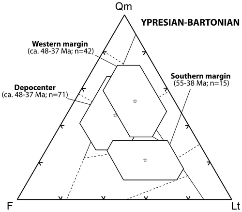
Ypresian-Bartonian sandstone samples from the southern basin margin are feldspathic litharenites (Qm21F30Lt49) (Figure ). Abundant epimetamorphic rock fragments are associated with a significant amount of ophiolitic and terrigenous carbonate detritus (d’Atri et al., Citation2012). Picotite is the only distinctive heavy mineral, in agreement with the presence of ophiolitic rock fragments. Within this succession, the Middle Eocene section is richer in low-grade metamorphic rock fragments that can be attributed to the erosion of the Rhodopian terrane of the Biga peninsula. Ophiolitic rocks and picotite occur as in the Early Eocene section, but terrigenous carbonate grains are virtually absent. Traces of epidote and titanite are sporadically present.
Ypresian-Bartonian sandstone samples from a number of oil wells in the basin central portion were studied by Büyükutku (Citation2005) (Figure ). Samples from the turbidites of the Hamitabat Group (Middle Eocene) have a composition (Qm47F30Lt23) (Figure ), largely similar to the one of coeval sandstone samples from the western margin. Phyllite and serpentinite lithic grains are present.
5.2. Priabonian-Rupelian detrital modes
Priabonian-Rupelian sandstone samples from the western basin margin in NE Greece and SE Bulgaria show two distinct, interbedded petrofacies: quartzofeldspathic and volcaniclastic (Figure , Table ). The quartzofeldspathic petrofacies is characterized by similar amounts of quartz and feldspar. Phaneritic rock fragments are represented by medium- to high-grade metamorphic rocks whereas plutonic rock fragments are minor. Aphanitic lithic grains mainly consist of phyllite, chlorite schist, epidote-bearing greenschist, and micaschist. Although the detrital supply from the Circum-Rhodope Belt is appreciable, most of the sediment was derived from the Rhodopes sensu stricto (Caracciolo et al., Citation2012).
Figure 4. Ternary diagram showing compositional characterization of Priabonian-Rupelian sandstone samples from different portions of the Thrace Basin. Qm, monocrystalline quartz grains; F, total feldspar grains; Lt, total aphanitic lithic fragments. Stars and polygons indicate means and standard deviations from the means, respectively. Data from Büyükutku (Citation2005), Caracciolo et al. (Citation2011, Citation2012), and d’Atri et al. (Citation2012). Fields within diagram are from Dickinson et al. (Citation1983) and Dickinson (Citation1985).
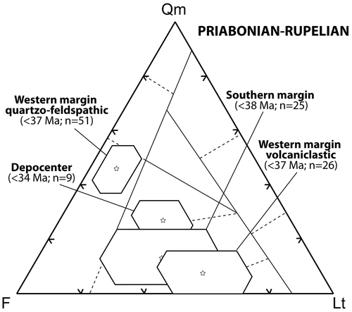
Neovolcanic grains, both as single crystals and as rock fragments, characterize the volcaniclastic petrofacies of the western margin (Caracciolo et al., Citation2011, Citation2012) (Figure ). Phaneritic rock fragments consist of volcanic rock fragments showing association of plagioclase and amphibole phenocrysts. Aphanitic lithic grains consist of fine-grained to vitric volcanic fragments and subordinate metamorphic (phyllite and mica schists) and sedimentary (extrabasinal carbonates) lithic fragments. Heavy-mineral content is generally high (up to 2% of total grains) and consists of pyroxenes and amphiboles, with subordinate sphene. Noncarbonate extrabasinal grains are represented solely by plagioclase, quartz, and K-feldspar.
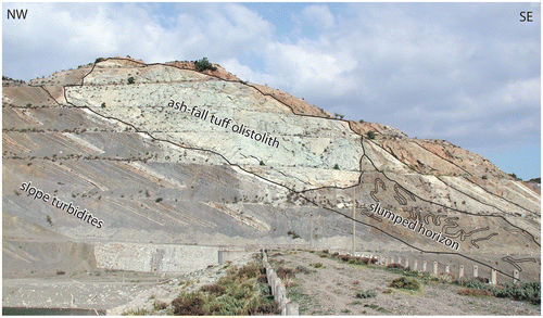
The Priabonian-Rupelian succession south of the Ganos Fault (“southern margin” petrofacies in Figure ) is characterized by arkosic litharenites. This interval features abundant neovolcanic and intrabasinal carbonate grains (some samples are hybrid arenites, sensu Zuffa, Citation1980). Other common framework components are (i) epimetamorphic and ophiolitic rock fragments and (ii) glaucophane and picotite grains, but their amounts are significantly lower compared to those of the Early-Middle Eocene section in the same region because the abundant carbonate intrabasinal and neo-volcanic grains dilute all other detrital components. Within the heavy-mineral association, titanite and augite characterize further this petrostratigraphic interval. In the upper part of the Tayfur section (Figure ), the volcanic component is very abundant and slumped turbidite slope deposits, including a large olistolith of penecontemporaneous vitric tuff, indicating a north-facing palaeoslope (Figure ). Despite the fact that significant neovolcanic detritus is present only in the upper parts of the Tayfur and Şarköy sections, it should be noted that volcanic detritus – mostly penecontemporaneous – is somewhat present in the uppermost Eocene–Oligocene section throughout the study area. Overall, detrital modes and the presence in several samples of glaucophane and epidote suggest a provenance from an exhumed subduction-accretion prism affected by volcanism.
Figure 5. Large vitric tuff olistolith (thickness ca. 15 m) and associated slump horizon within slope turbidites of the upper Tayfur Formation (Early Oligocene) at Tayfur Reservoir (Gelibolu Peninsula) (Figure ). 40Ar–39Ar analyses of feldpars from the tuff olistolith yielded an eruption age of 30.22 ± .20 Ma (d’Atri et al., Citation2012). The abundance of penecontemporaneous volcaniclastic detritus throughout the upper Tayfur Fm. points to a virtual coincidence between tuff age and depositional age of the upper Tayfur Fm. Orientation of slump fold axes indicate a north-facing paleoslope, in agreement with paleoflow indicators from the turbidite beds (Figure ).
Petrographic analyses of Late Eocene–Early Oligocene sandstone samples from the subsurface in the central area of the Thrace Basin are unavailable. The samples closest to the central portion of the Thrace Basin are those from the middle and upper Korudağ stratigraphic section (Figures and ). This group of samples has a composition intermediate between the western quartzofeldpathic petrofacies and the volcaniclastic petrofacies of both the western and southern margins (Figure ).
5.3. Reconstruction of sediment dispersal pathways and paleoenvironments
The study area covers a significant portion of the Thrace Basin and the results of this study provide new compelling constraints on its sediment dispersal pattern and overall stratigraphic architecture. Figure is a tentative reconstruction of the overall sediment dispersal pattern of the Thrace Basin. In the figure, considering that the study area comprises the most active strand of the North Anatolian Fault system (Figure ), a conservative Plio-Quaternary dextral strike-slip offset of ca. 70 km (Armijo, Meyer, Hubert, & Barka, Citation1999) was restored.
Figure 6. Schematic reconstruction of Middle Eocene–Early Oligocene provenance and overall sediment dispersal pathways in the Thrace Basin. Small arrows show mean azimuth paleoflow directions. Plio-Quaternary dextral offset of about 70 km along the North Anatolian Fault was restored. Red lines are normal (ticks on downthrown side) and strike-slip faults. Depth-to-basement contour lines (in meters) from Siyako (Citation2006).
Paleocurrent trends, sedimentological/stratigraphic analysis, and sandstone detrital modes indicate that an important sediment source area was located to the south and southwest, along the Vardar-Izmir-Ankara suture (d’Atri et al., Citation2012; Okay et al., Citation2010). This is evident in the Gelibolu peninsula south of the Ganos Fault, which marked the site of an escarpment active throughout the Eocene and separating a shallow marine area to the south from a deep basin to the north (Doust & Arıkan, Citation1974). Sediment derived from the erosion of the Vardar-Izmir-Ankara orogenic prism is characterized by ophiolitic detritus, including a deep-sea sedimentary cover. Epimetamorphic and granitoid detritus is also present. Starting from Late Eocene time, a significant penecontemporaneous volcanic component is characteristic. Within this later phase, the coexistence of pure neovolcanic layers (crystal tuffs) and hybrid carbonate-rich arenites with detritus derived from a continental basement indicates the presence of episutural basin(s) where shallow-water carbonates were deposited on top of the exhuming subduction-accretion prism (d’Atri et al., Citation2012). These carbonates were mixed with penecontemporaneous neovolcanic components and redeposited in deeper marine environments. The entire southern Thrace Basin was fed from the south and southwest. The precise delineation of the sediment dispersal pattern toward the southwest (i.e. in the northern Aegean) is hampered by the fact that most of this region is now underwater, but observations on the islands of Lemnos (Caracciolo et al., Citation2011; Maravelis, Konstantopoulos, Pantopoulos, & Zelilidis, Citation2007), Gökçeada (d’Atri et al., Citation2012), and Bozcaada (Temel & Çiftçi, Citation2002) substantiate this reconstruction.
Other elements pointing to a southern provenance are (i) large olistoliths and olistostromes enclosed in the Eocene turbidites in the Şarköy region along the southern margin of the basin (Okay et al., Citation2010), and (ii) large Oligocene deltaic bodies generically prograding northeastward in the same region (Osmancık Formation, Atalik, Citation1992). Both elements point to a prolonged history of northward sediment dispersal, in agreement with our sandstone petrographic data and sedimentological observations. During most of the Eocene, the entire basin was characterized by a complex physiography featuring a series of structural highs trending generically east-west, as shown by both commercial seismic lines (e.g. Turgut et al., Citation1991) and dramatic lateral facies changes at the surface (e.g. Siyako & Huvaz, Citation2007). Such configuration influenced greatly the sediment dispersal pattern and the local rates of sedimentation.
A second, important sediment source area was the plutono-metamorphic Rhodope Massif west of the basin (Caracciolo et al., Citation2011, Citation2012). The coarse-grained fan-deltas characterizing the Eocene section along the western margin of the basin in Greece and Bulgaria were the entry points associated with this second sediment source area. The detritus generated in this area was then dispersed eastward within a complex system of depocenters (Figure ). The Rhodopian provenance underwent significant changes through time, the progressively increasing content of amphibolite, and gneissic metamorphic grains reflecting progressive unroofing of the Variegated Complex (Caracciolo et al., Citation2012). Since the late Eocene, the source-basin system underwent an abrupt change in structural style with the onset of general extension leading to the exhumation of the Gneiss–Migmatite core complex and concurrent widespread volcanism. As a consequence, sandstone composition evolved from quartzolithic to quartzofeldspathic/volcaniclastic.
Middle Eocene–Early Oligocene sedimentary deposits cropping out in the Alexandropoulos-Komotini region and in southern Thrace show consistent eastward paleocurrents. Therefore, supply could be thought as the same for both the Greek and Turkish sectors of the Thrace Basin. However, sandstone gross compositions for the two regions are substantially different (Figures and ). In the Alexandropoulos-Komotini region sandstone detrital modes can be linked directly to the Rhodopian Massif (Caracciolo et al., Citation2011; Caracciolo, Critelli, Innocenti, Kolios, & Manetti, Citation2013; Caracciolo et al., Citation2012; Marchev et al., Citation2004), whereas in the southernmost Thrace Basin the provenance was from an exhumed accretionary wedge (d’Atri et al., Citation2012). In the latter region, sediment palaeodispersal was then deflected toward the east along the axes of a number of elongated depocenters (Doust & Arıkan, Citation1974; Perinçek, Citation1991; Turgut et al., Citation1991).
The Korudağ and Ganos Mountain stratigraphic sections cover together the Middle Eocene–Late Oligocene time span and are both made of deep-sea turbidites gradually evolving upsection into slope, shelfal, and deltaic deposits (Figure ). Palaeocurrent measurements north of the Ganos Fault indicate palaeoflows consistently directed toward the ESE (d’Atri et al., Citation2012; Görür & Okay, Citation1996; Siyako & Huvaz, Citation2007; Sümengen & Terlemez, Citation1991; Turgut & Eseller, Citation2000). Such palaeocurrents may be compatible with turbidite flows derived from either (i) the Rhodopes or (ii) the eastward deflection of turbidite flows originally derived from the southern basin margin. The fact that this petrofacies does not match neither a Rhodopian (cf. Caracciolo et al., Citation2011) nor a southern (cf. d’Atri et al., Citation2012) provenance points either to a mixture of the two detrital inputs or to an unspecified third input from the region now covered by the northern Aegean Sea.
Our petrographic analyses indicate that the Ypresian-Bartonian sediment source areas for the Thrace Basin sediments were characterized by ophiolitic source rocks and their pelagic sedimentary cover. The Vardar-İzmir-Ankara subduction/accretion wedge associated with the closure of a branch of the Neotethys and the more northern Biga subduction/accretion wedge (Çetmi mélange) –whether or not associated with the westward continuation of the Intra-Pontide suture (Okay, Satır, Tüysüz, Akyüz, & Chen, Citation2001; Okay et al., Citation2008; Okay & Tüysüz, Citation1999) – are the obvious source-area candidates for the detritus forming the Ypresian-Bartonian succession. An important southern provenance is also shown by palaeocurrent trends and palaeoslope orientation as shown by slump features and olistoliths.
Pure neovolcanic fallout beds and turbidite strata of hybrid arenites compositionally characterize the Late Eocene–Early Oligocene succession of the Thrace Basin. The composition of the arenite framework, made of carbonate intrabasinal grains (bioclasts and peloids) and by pristine neovolcanic grains locally coated by carbonate rims, points to the existence of a shallow-water intrabasinal source area where carbonate grains were generated and mixed with pyroclastic detritus from penecontemporaneous volcanism. Such shallow-water sediment accumulations were then periodically mobilized as gravity flows and redeposited into slope/basinal environments, resulting in hybrid arenitic turbidites (d’Atri et al., Citation2012). As for the lower part of the southern petrofacies, granitic/gneissic, epimetamorphic and ophiolitic lithic grains, and picotite are present, but their amount is significantly lower because of the abundant carbonate intrabasinal grain and neo-volcanic grains that dilute all other components.
The turbiditic succession of the Çengelli Formation along the Şarköy stratigraphic section (Figure ) features thick proximal olistostromes and giant olistoliths (Okay et al., Citation2010). Clast composition is scale-invariant, from sand grains to olistoliths up to 1 km across: serpentinite, gabbro, basalt, greenschist, greywacke, Cretaceous-Paleocene pelagic limestone, and the underlying Upper Bartonian-Lower Priabonian Soğucak Limestone (Özcan et al., Citation2007). Composite olistoliths consisting of pelagic limestone or basalt overlain by the Soğucak Limestone are common, providing further evidence for synsedimentary tectonics. The Upper Eocene mass flows of the Çengelli Fm were formed in an extensional setting and were derived from the south from the flanks of large normal or transtensional faults related to the opening of the southern Thrace Basin (Okay et al., Citation2010). The entire Şarköy section indicates a provenance from the ophiolitic suite of an exhumed subduction-accretion prism located to the south. The occurrence of serpentinite lithic fragments and glaucophane grains is in agreement with this interpretation.
6. Discussion
A thorough paleogeographic/paleoenvironmental reconstruction of the Thrace Basin is hampered by the high degree of tectonic overprint – including large-scale extension in the Aegean and peri-Aegean regions as well as strike-slip deformation related to the westward propagation of the North Anatolian Fault – which has largely obscured the original facies pattern in most of the southern and western basin margins. Despite these complexities, the integration of preexisting and new data presented in this paper places significant constraints on the overall evolution of the basin and its tectonic interpretation.
The Thrace Basin has been interpreted as a forearc basin which developed in a context of northward subduction (Görür & Okay, Citation1996). This interpretation is challenged by the lack of a coeval magmatic arc along its northern (Strandja) margin. Besides, penecontemporaneous volcanism kicked off late in the basin evolution (Caracciolo et al., Citation2011, Citation2012; d’Atri et al., Citation2012; Innocenti et al., Citation1984; Yanev, Citation1998; Yanev, Innocenti, Manetti, & Serri, Citation1998) in contrast with typical forearc basins (for a review, see Dickinson, Citation1995). The interpretation of the Thrace Basin as a forearc basin was also based on the occurrence, along its southern margin in the Gelibolu peninsula, of a belt of chaotic deposits long interpreted as a tectonic mélange formed in situ in an accretionary prism (Beccaletto, Citation2004; Beccaletto et al., Citation2005). Recently, Okay et al. (Citation2010) demonstrated instead that such belt was derived from the erosion and sedimentary reworking (olistoliths and large submarine slumps) of an older mélange unit (Çetmi mélange) located to the south. Despite several examples of sedimentary reworking of tectonic mélange from accretionary prisms into adjacent forearc basins (see Cavazza and Barone (Citation2010), for a review), the long time span (>30 Ma) between the youngest age of the Çetmi mélange (Turonian) and the base of the Thrace Basin fill indicates that the accretionary prism was inactive when the Thrace Basin was formed. We propose that the Thrace Basin is instead the result of one of the following processes: (i) post-orogenic collapse after the continental collision related to the closure of the Vardar ocean, (ii) upper-plate extension related to slab retreat in front of the Pindos remnant ocean (d’Atri et al., Citation2012), or (iii) a combination of these two processes.
The Vardar-İzmir-Ankara-Erzincan suture represents the major neo-Tethyan suture between Laurasian and Gondwanian terranes in southeastern Europe and Asia Minor (Figure ). It can be traced for at least 2,000 km from the Balkans to the Lesser Caucasus, where it continues southeastward as the Sevan-Akera suture (Adamia et al., Citation2011; Khain, Citation1994; Okay & Tüysüz, Citation1999). The Vardar segment of this important suture system separates the Rhodope and Serbo-Macedonian massifs in the north from the Hellenides in the south. Subduction and closure of the Vardar Ocean occurred in the Late Cretaceous–Early Paleogene. The nappes were stacked by southward thrusting in the hanging wall of the north-dipping subduction of the Vardar slab, rooted in the present-day Vardar suture zone (Bonev & Beccaletto, Citation2007; Ricou, Burg, Godfriaux, & Ivanov, Citation1998). Despite contrasting models for the details of the following evolution of the Vardar orogen (e.g. Burg et al., Citation1996; Krohe & Mposkos, Citation2002), stratigraphic evidence clearly points to widespread overall extension from the Late Eocene (e.g. Burchfiel, Nakov, & Tzankov, Citation2003). The İzmir-Ankara-Erzincan suture can be traced south of the Biga peninsula; in this region, the structural evolution is similar to the one outlined above for the Vardar segment.
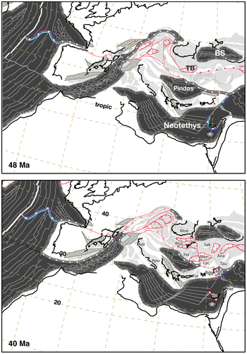
Despite being ideally located for recording the complex transition from compression to extension along the Vardar-İzmir-Ankara-Erzincan orogenic wedge, the Thrace Basin has been largely ignored in most paleotectonic-paleogeographic reconstructions. Notable exceptions are Stampfli and Borel (Citation2004) and Stampfli and Hochard (Citation2009), showing the Thrace Basin straddling the inactive Vardar-İzmir-Ankara-Erzincan suture and facing the northward subducting Pindos remnant ocean (Figure ). This reconstruction implies that upper-plate extension was largely driven by slab rollback along the retreating subduction zone along the northern margin of the Pindos Ocean. We argue that the complex physiography of the Thrace Basin described earlier was inherited by a previous structural regime, most likely during late-collisional strike-slip tectonism. This is demonstrated by the fact that the basin-fill succession onlaps passively such physiography (Turgut et al., Citation1991). Further accommodation was generated over a wider area during the rest of the Eocene and in the Oligocene during extension, in agreement with the timing and areal distribution of crustal stretching phenomena common during this time span over the entire northern Aegean region. This latter phase is characterized by a significant penecontemporaneous volcanic detrital input, as shown by this study. The coexistence of pure neovolcanic layers (crystal tuffs and cinerites) and hybrid arenites rich in penecontemporaneous carbonate grains with sands derived from a continental basement and ophiolitic suites indicates the presence of episutural basins where shallow-water carbonates were deposited on top of the exhuming subduction-accretion prism. These carbonates were mixed with penecontemporaneous neovolcanic and terrigeneous components and redeposited in deeper marine environments.
Figure 7. Lutetian-Bartonian (Middle Eocene) paleogeographic reconstructions (from Stampfli and Hochard (Citation2009), modified). Following the closure of the Vardar-Izmir-Ankara ocean, the subduction of the Pindos and Troodos oceanic slabs triggered upper-plate extension and the opening of numerous rifts and associated core-complexes in Turkey, in the Cyclades, and in the Balkans. The Thrace Basin developed within this framework of post-collisional extension in the area facing the subducting remnant Pindos Ocean. Abbreviations: Adr, Adria; Ana, Anatolides; Ant, Antalya; Apu, Apulia; Bdg, Beydaglari; BS, Black Sea; Hat, Hatay; Lyc, Lycian; Men, Menderes; Moe, Moesia; Pel, Pelagonian; Rho, Rhodope; Sak, Sakarya; Tau, Taurus; TB, Thrace Basin; Tro, Troodos.
Zattin, Okay, and Cavazza (Citation2005) and Zattin et al. (Citation2010) showed that the Ganos segment of the North Anatolian Fault had a late Oligocene precursor with a significant dip-slip component. Abrupt palaeoenvironmental variations between time-equivalent stratigraphic horizons across the Ganos Fault (e.g. Doust & Arıkan, Citation1974) support the notion that during the Eocene a structural discontinuity was already active along the trace of the present-day Ganos Fault, in line with the documented existence of a number of elongated structural highs and lows influencing the sediment dispersal pattern and the areal distribution of palaeoenvironments across the Thrace Basin (Perinçek, Citation1991; Turgut et al., Citation1991). In the Palaeocene, a paleo-Ganos Fault may have been active taking up the lateral component of oblique subduction, similar to the strike-slip faults north of the Sumatra-Java trenches in southeast Asia (e.g. Hamilton, Citation1979), as first proposed by Okay et al. (Citation2010). In the Pliocene (Armijo et al., Citation1999), the present-day North Anatolian Fault reactivated this older tectonic structure.
Such strike-slip-dominated tectonic scenario during the late- and post-collisional stages related to the closure of the Vardar-İzmir-Ankara Ocean is further corroborated by the presence of an important strike-slip shear zone of crustal relevance in the region just southeast of the Marmara Sea (Okay et al., Citation2008). Such shear zone is at least 225 km long, has an horizontal offset of about 100 km, and has a trend similar to the present-day North Anatolian Fault.
7. Conclusions
The integration of (i) paleoflow measurements, (ii) qualitative sedimentological observations, and (iii) detailed petrographic observations for discriminating palaeo- vs. neovolcanic and penecontemporaneous vs. noncoeval terrigenous sands leads to a substantial revision of the geodynamic interpretation of the Thrace Basin, formerly considered a forearc basin. The Thrace Basin sedimentary fill was mostly derived from (i) the Rhodopian basement complex to the west and (ii) the Vardar-İzmir-Ankara and Biga (?Intra-Pontide) subduction/accretion complexes to the south and southwest. Significant detrital input from the northern margin started only in the Oligocene. Proximal facies along the southern basin margin consistently show northward palaeocurrents whereas most palaeocurrent indicators measured downcurrent point to an eastward palaeoflow, likely the result of the deflection of primary gravity flows originated along the southern basin margin. Rhodopes-derived, Eocene proximal facies in northeastern Greece and southeastern Bulgaria feature a series of coarse-grained fan-deltas and alluvial fans prograding generically eastward. The latter were the sediment entry points likely feeding the basin-plain turbidites of the central portion of the Thrace Basin, now concealed in the subsurface.
The Thrace Basin developed during the transition between the collisional tectonic regime following the closure of Vardar-İzmir-Ankara oceanic realm and the extensional regime characterizing the Oligocene-Neogene evolution of the Aegean and periAegean regions. It was long interpreted as a forearc basin which developed in a context of northward subduction but the lack of a coeval magmatic arc in the Strandja Massif indicates otherwise. This element – along with the correspondence between subsidence pulses in the basin and lithospheric stretching in the metamorphic core complexes of southern Bulgaria and the northern Aegean region – may indicate instead that the Thrace Basin was the result of upper-plate extension and/or post-orogenic collapse following the continental collision related to the closure of the Vardar Ocean. Preliminary data indicate that initial subsidence (Ypresian-Bartonian) was localized in small depocenters delimited by a system of strike-slip faults, probably during the late stages of collision. Further, extension-driven subsidence over a wider area occurred during Priabonian-Oligocene, in agreement with the timing and areal distribution of crustal stretching phenomena evident during this length of time over the entire northern Aegean region. This hypothetical two-stage evolutionary trend might represent a predictive tool in the tectonostratigraphic interpretation of other post-orogenic sedimentary basins.
Acknowledgements
Many thanks to Aral I. Okay, who patiently introduced William Cavazza to the geology of Turkey, sharing graciously his expertise through the years. Thanks are also due to Rocco Dominici, Niko Kolios, Piero Manetti, Francesco Muto, and the late Fabrizio Innocenti for their participation during early stages of this study. Thorough reviews by Ercan Özcan and Muzaffer Siyako greatly improved the manuscript. This research was sponsored by MIUR (Italian Ministry of Public Education, University and Research).
References
- Adamia, S., Zakariadze, G., Chkhotua, T., Sadradze, N., Tsereteli, N., Chabukiani, A., & Gventsadze, A. (2011). Geology of the Caucasus: A review. Turkish Journal of Earth Sciences, 20, 489–544.
- Aksoy, Z. (1987). Depositional environment of the sequences in the Barbaros-Keşan-Kadıköy-Gaziköy region (southern Thrace). Proceedings of the 7th Petroleum Congress of Turkey, Ankara, 292–311 (in Turkish).
- Andronopoulos, B. (1978). Geological map of Greece. Ormenion sheet, scale 1:50,000. Athens: IGME.
- Armijo, R., Meyer, B., Hubert, A., & Barka, A. (1999). Westward propagation of the North Anatolian fault into the northern Aegean: Timing and kinematics. Geology, 27, 267–270.10.1130/0091-7613(1999)027<0267:WPOTNA>2.3.CO;2
- Atalık, E. (1992). Depositional systems of the Osmancık Formation in the Thrace Basin ( PhD dissertation). Middle East Technical University, p. 366.
- Beccaletto, L. (2004). Geology, correlations and geodynamic evolution of the Biga Peninsula (NW Turkey) (PhD dissertation). Universitè de Lausanne, Suisse.
- Beccaletto, L., Bartolini, A. C., Martini, R., Hochuli, P. A., & Kozur, H. (2005). Biostratigraphic data from the Çetmi Mélange, northwest Turkey: Palaeogeographic and tectonic implications. Palaeogeography, Palaeoclimatology, Palaeoecology, 221, 215–244.10.1016/j.palaeo.2005.02.011
- Beccaletto, L., Bonev, N., Bosch, D., & Bruguier, O. (2007). Record of a Paleogene syn-collisional extension in the north Aegean region: Evidence from the Kemer micaschists (NW Turkey). Geological Magazine, 144, 393–400.10.1017/S001675680700310X
- Bonev, N. G. (2006). Cenozoic tectonic evolution of the Eastern Rhodope Massif (Bulgaria): Basement structure and kinematics of syn- to postcollisional extensional deformation. Geological Society of America Special Paper, 409, 211–235.
- Bonev, N. G., & Beccaletto, L. (2007). From syn- to post-orogenic Tertiary extension in the north Aegean region: Constraints on the kinematics in the eastern Rhodope–Thrace, Bulgaria–Greece and the Biga Peninsula (NW Turkey). Geological Society, London, Special Publications, 291, 113–142.10.1144/SP291.6
- Bonev, N. G., & Stampfli, G. M. (2003). New structural and petrologic data on Mesozoic schists in the Rhodope (Bulgaria): Geodynamic implications. Comptes Rendus Geoscience, 335, 691–699.10.1016/S1631-0713(03)00122-6
- Burchfiel, B. C., Nakov, R., & Tzankov, T. (2003). Evidence from the Mesta half-graben, SW Bulgaria, for the Late Eocene beginning of Aegean extension in the Central Balkan Peninsula. Tectonophysics, 375, 61–76.10.1016/j.tecto.2003.09.001
- Burchfiel, B. C., Nakov, R., Tzankov, T., & Royden, L. H. (2000). Cenozoic extension in Bulgaria and northern Greece: The northern part of the Aegean extensional regime. In E. Bozkurt, J. A. Winchester, & J. D. A. Piper (Eds.), Tectonics and magmatism in Turkey and the surrounding area (Vol. 173, pp. 325–352. Geological Society of London, Special Publications, London.
- Burg, J.-P., Ricou, L.-E., Ivanov, Z., Godfriaux, I., Dimov, D., & Klain, L. (1996). Syn-metamorphic nappe complex in the Rhodope Massif, structure and kinematics. Terra Nova, 8, 6–15.10.1111/ter.1996.8.issue-1
- Burke, W. F., & Ugurtas, G. (1974). Seismic interpretation of Thrace Basin. Proceedings Second Petroleum Congress of Turkey, TPAO Internal Report, Ankara, 229–249.
- Büyükutku, A. G. (2005). Sandstone petrology and tectonostratigraphic terranes of the nortwestern Thrace Basin, Turkey. Journal of the Geological Society of India, 65, 231–238.
- Caracciolo, L., Critelli, S., Innocenti, F., Kolios, N., & Manetti, P. (2011). Unraveling provenance from Eocene-Miocene sandstones of the Thrace Basin, NE Greece. Sedimentology, 58, 1988–2011.10.1111/sed.2011.58.issue-7
- Caracciolo, L., Critelli, S., Innocenti, F., Kolios, N., & Manetti, P. (2013). Reply to the discussion by Maravelis and Zelilidis on “Unravelling provenance from Eocene–Oligocene sandstones of the Thrace Basin, North-east Greece” by Caracciolo et al. (2011). Sedimentology, 60, 865–869.10.1111/j.1365-3091.2012.01368.x
- Caracciolo, L., Von Eynatten, H., Tolosana-Delgado, R., Critelli, S., Manetti, P., & Marchev, P. (2012). Petrological, geochemical, and statistical analysis of Eocene–Oligocene sandstones of the western Thrace Basin, Greece and Bulgaria. Journal of Sedimentary Research, 82, 482–498.10.2110/jsr.2012.31
- Cavazza, W., & Barone, M. (2010). Large-scale sedimentary recycling of tectonic mélange in a forearc setting: The Ionian basin (Oligocene-Quaternary, southern Italy). Geological Society of America Bulletin, 122, 1932–1949.10.1130/B30177.1
- Cavazza, W., Federici, I., Okay, A. I., & Zattin, M. (2012). Pre-Cenozoic amalgamation of the İstanbul and Sakarya terranes (NW Turkey) – Evidence from low-temperature thermochronology. Geological Magazine, 149, 133–140.10.1017/S0016756811000525
- Cavazza, W., Okay, A. I., & Zattin, M. (2009). Rapid early-middle Miocene exhumation of the Kazdağ metamophic core complex (Western Anatolia). International Journal of Earth Sciences, 98, 1935–1947. doi:10.1007/s00531-008-0353-910.1007/s00531-008-0353-9
- Critelli, S., & Ingersoll, R. V. (1995). Interpretation of neovolcanic versus palaeovolcanic sand grains – An example from Miocene deep-marine sandstones of the Topanga Group (southern California). Sedimentology, 42, 783–804.10.1111/sed.1995.42.issue-5
- d’Atri, A., Zuffa, G. G., Cavazza, W., Okay, A. I., & Di Vincenzo, G. (2012). Sediment paleodispersal pattern of the Eocene-Oligocene southern Thrace Basin (NW Turkey and NE Greece). Sedimentary Geology, 243–244, 117–129.10.1016/j.sedgeo.2011.10.008
- Dickinson, W. R. (1970). Interpreting detrital modes of graywacke and arkose. Journal of Sedimentary Petrology, 40, 695–707.
- Dickinson, W. R. (1985). Interpreting provenance relations from detrital modes of sandstone. In G. G. Zuffa (Ed.), Provenance of Arenites (pp. 333–361). Dordrecht: Kluwer Academic.
- Dickinson, W. R. (1995). Forearc basins. In C. J. Busby & R. V. Ingersoll (Eds.), Tectonics of sedimentary basins (pp. 221–262). Oxford: Blackwell Science.
- Dickinson, W. R., Beard, L. S., Brakenridge, C. R., Erjavec, J. L., Ferguson, R. C., Inman, K. F., … Ryberg, P. T. (1983). Provenance of North America Phanerozoic sandstones in relation to tectonic setting. Geological Society of America Bulletin, 94, 222–235.10.1130/0016-7606(1983)94<222:PONAPS>2.0.CO;2
- Doust, H., & Arıkan, Y. (1974). The geology of the Thrace Basin. Proceedings of the 7th Petroleum Congress of Turkey, Ankara, 119–136.
- Gazzi, P. (1966). Sandstones of the post-Cretaceous flysch of the Modena Apennines; correlations with the Monghidoro flysch. Mineralogica et Petrografica Acta, 12, 69–97.
- Gazzi, P., Zuffa, G. G., Gandolfi, G., & Paganelli, L. (1973). Provenance and longshore dispersal of the Adriatic beach sands between the mouths of the Isonzo and Foglia rivers: regional framework. Memorie Società Geologica Italiana, 12, 1–37.
- Görür, N., Monod, O., Okay, A. I., Şengör, A. M. C., Tüysüz, O., Yiğitbaş, E., Sakinç, M., & Akkök, R. (1997). Palaeogeographic and tectonic position of the Carboniferous rocks of the western Pontides (Turkey) in the frame of the Variscan belt. Bulletin de la Societe Geologique de France, 168, 197–205.
- Görür, N., & Okay, A. I. (1996). A fore-arc origin for the Thrace Basin (NW Turkey). Geologische Rundschau, 85, 662–668.
- Gradstein, F. M., Ogg, J. G. & Smith, A. G., (2004). A geological time scale 2004. Cambridge University Press.10.4095/215638
- Hamilton, W. (1979). Tectonics of the Indonesian region. US Geological Survey Professional Paper 1078.
- Huvaz, O., Sarıkaya, H., & Nohut, O. M. (2005). Nature of a regional dogleg pattern in maturity profiles of the Thrace Basin, northwestern Turkey: A newly discovered unconformity or a thermal anomaly? AAPG Bulletin, 89, 1373–1396.10.1306/06090505021
- Ingersoll, R. V., Bullard, T. F., Ford, R. L., Grimm, J. B., Pickle, J. D., & Sares, S. W. (1984). The effect of grain size on detrital modes: A test of the Gazzi–Dickinson point-counting method. Journal of Sedimentary Petrology, 54, 103–116 ( Also, see discussions and replies: 55, 616–621).
- Ingersoll, R. V., Cavazza, W., Graham, S. A., & Indiana Geologic Field Seminar Participants (1987). Provenance of impure calclithites in the Laramide foreland of southwestern Montana. Journal of Sedimentary Petrology, 57, 995–1003.
- Innocenti, F., Kolios, N., Manetti, P., Mazzuoli, R., Peccerillo, A., Rita, F., & Villari, L. (1984). Evolution and geodynamic significance of the Tertiary orogenic volcanism in Northeastern Greece. Bulletin Volcanologique, 47, 25–37.10.1007/BF01960538
- Keskin, E. (1984). Geology of the area of Pinarhisar. Türkiye Jeoloji Kurumu Bülteni, 14, 31–84.
- Khain, V. E. (1994). Geology of the Northern Eurasia (Ex-USSR). Gebrüder Borntraeger, Stuttgart, p. 404.
- Konak, N. (2002). Geological map of Turkey. İstanbul sheet, scale 1:500,000. Ankara: General Directorate of the Mineral Research and Exploration (MTA).
- Krohe, A., & Mposkos, A. (2002). Multiple generations of extensional detachments in the Rhodope Mountains (northern Greece): Evidence of episodic exhumation of high-pressure rocks. Geological Society London Special Publications, 204, 151–178.10.1144/GSL.SP.2002.204.01.10
- Less, G., Özcan, E., & Okay, A. I. (2011). Larger foraminiferal stratigraphy and paleoenvironments of the Middle Eocene to Lower Oligocene shallow-marine units in the northern and eastern parts of the Thrace Basin (NW Turkey). Turkish Journal of Earth Sciences, 20, 793–845.
- Maratos, G., Andronopoulos, V., & Koukouzas, K. (1977). Geological map of Greece. Alexandroupolis sheet, scale 1:50,000. Athens: IGME.
- Maravelis, A., Konstantopoulos, P., Pantopoulos, G., & Zelilidis, A. (2007). North Aegean sedimentary basin evolution during the Late Eocene to Early Oligocene based on sedimentological studies on Lemnos Island (NE Greece). Geologica Carpatica, 58, 455–464.
- Marchev, P., Raicheva, R., Downes, H., Vaselli, O., Chiaradia, M., & Moritz, R. (2004). Compositional diversity of Eocene-Oligocene basaltic magmatism in the Eastern Rhodopes, SE Bulgaria: Implications for genesis and tectonic setting. Tectonophysics, 393, 301–328.10.1016/j.tecto.2004.07.045
- Okay, A. I., Özcan, E., Cavazza, W., Okay, N., & Less, G. (2010). Basement types, Lower Eocene series, Upper Eocene olistostromes and the initiation of the southern Thrace Basin (NW Turkey). Turkish Journal of Earth Sciences, 19, 1–25. doi:10.3906/yer-0902-10
- Okay, A. I., Satır, M., Tüysüz, O., Akyüz, S., & Chen, F. (2001). The tectonics of the Strandja Massif: Late-Variscan and mid-Mesozoic deformation and metamorphism in the northern Aegean. International Journal of Earth Sciences, 90, 217–233.
- Okay, A. I., Satır, M., Zattin, M., Cavazza, W., & Topuz, G. (2008). An Oligocene ductile strike-slip shear zone: The Uludağ Massif, northwest Turkey – Implication for the westward translation of Anatolia. Geological Society of American Bulletin, 120, 893–911.10.1130/B26229.1
- Okay, A. I., Siyako, M., & Bürkan, K. A. (1991). Geology and tectonic evolution of the Biga peninsula, northwest Turkey. Bulletin of the Istanbul Technical University, 44, 191–256.
- Okay, A. I., & Tüysüz, O. (1999). Tethyan sutures of northern Turkey. In B. Durand, L. Jolivet, F. Horvath, & M. Seranne (Eds.), The Mediterranean Basins: Tertiary extension within the Alpine Orogen (Vol. 156, pp. 475–515). London: Geological Society of London, Special Publications.
- Okay, A. I., Tüysüz, O., & Kaya, S. (2004). From transpression to transtension: Changes in morphology and structure around a bend on the North Anatolian Fault in the Marmara region. Tectonophysics, 391, 259–282.10.1016/j.tecto.2004.07.016
- Okay, N., Zack, T., Okay, A. I., & Barth, M. (2011). Sinistral transport along the Trans-European Suture Zone: Detrital zircon-rutile geochronology and sandstone petrography from the Carboniferous flysch of the Pontides. Geological Magazine, 148, 380–403.10.1017/S0016756810000804
- Önal, M. (1986). Gelibolu yarımadası orta bölümünün sedimanter fasiyesleri ve tektonic evrimi, KB Anadolu, Türkiye [Sedimentary facies and tectonic evolution of the central part of the Gelibolu Peninsula, NW Anatolia, Turkey]. Jeoloji Mühendisliği, 29, 37–46 [in Turkish].
- Özcan, E., Less, G., Baldi-Beke, M., Kollanyi, K., & Kertesz, B. (2007). Biometric analysis of middle and upper Eocene Discocyclinidae and Orbitoclypeidae (Foraminifera) from Turkey and updated orthophragmine Zonation in the Western Tethys. Micropaleontology, 52, 485–520.
- Özcan, E., Less, G., Okay, A. I., Báldi-Beke, M., Kollányi, K., & Yilmaz, İ. Ö. (2010). Stratigraphy and larger foraminifera of the Eocene shallow-marine and olistostromal units of the southern part of the Thrace Basin (NW Turkey). Turkish Journal of Earth Sciences, 19, 27–77.
- Papadopoulos, P. (1980). Geological map of Greece. Ferai sheet, scale 1:50,000. Athens: IGME.
- Perinçek, D. (1991). Possible strand of the North Anatolian fault in the Thrace Basin, Turkey – An interpretation. American Association of Petroleum Geologists Bulletin, 75, 241–257.
- Ricou, L.-E., Burg, J.-P., Godfriaux, I., & Ivanov, Z. (1998). Rhodope and Vardar: The metamorphic and the olistostromic paired belts related to the Cretaceous subduction under Europe. Geodinamica Acta, 11, 285–309.10.1016/S0985-3111(99)80018-7
- Saner, S. (1985). Depositional succession and tectonic setting of the Saros Gulf, northeastern Aegean Sea (Turkey). Türkiye Jeoloji Kurumu Bülteni, 28, 1–10 [in Turkish].
- Şen, Ş. (2002). Collisional-backthrust basin model for the Thrace-Göynük-Safranbolu basin (NW Turkey). International Conference on Earth Sciences and Electronics (ICESE-2002), 65–76.
- Şengör, A. M. C., & Yılmaz, Y. (1981). Tethyan evolution of Turkey: A plate tectonic approach. Tectonophysics, 75, 181–241.
- Siyako, M. (2006). Trakya havzası Tersiyer kaya birimleri [Tertiary rock units of the Thrace Basin]. In Trakya Bölgesi Litostratigrafi Birimleri [Lithostratigraphic units of the Thrace Region]. Litostratigrafi Birimleri Serisi 2 (pp. 43–83. Ankara: Publication of the General Directorate of the Mineral Research and Exploration (MTA) [in Turkish].
- Siyako, M., & Huvaz, O. (2007). Eocene stratigraphic evolution of the Thrace Basin, Turkey. Sedimentary Geology, 198, 75–91.10.1016/j.sedgeo.2006.11.008
- Siyako, M., Bürkan, K. A., & Okay, A. I. (1989). Biga ve Gelibolu yarımadalarının Tersiyer jeolojisi ve hidrokarbon olanaklari [Tertiary geology and hydrocarbon potential of the Biga and Gelibolu peninsula]. TPJD Bülteni, 1, 183–199 [in Turkish].
- Stampfli, G. M., & Borel, G. D. (2004). The TRANSMED transects in space and time: constraints on the Paleotectonic evolution of the Mediterranean domain. In W. Cavazza, F. Roure, W. Spakman, G. M. Stampfli, & P. Ziegler (Eds.), The TRANSMED Atlas: The Mediterranean region from crust to mantle (pp. 53–80). Berlin: Springer Verlag.
- Stampfli, G., & Hochard, C. (2009). Plate tectonics of the Alpine realm. Geological Society of London Special Publication, 327, 89–111.10.1144/SP327.6
- Sümengen, M., & Terlemez, I. (1991). Stratigraphy of Eocene sediments in the southwest Thrace. Bulletin of the Mineral Research and Exploration, 113, 15–29.
- Sümengen, M., Terlemez, I., Şentürk, K., & Karaköse, C. (1987). Stratigraphy, sedimentology and tectonics of the Gelibolu Peninsula and southwestern Thrace Basin (Internal Report of the Maden Tetkik ve Arama Enstitüsü 8128). Ankara [in Turkish].
- Temel, R. Ö., & Çiftçi, N. B. (2002). Gelibolu yarımadası, Gökçeada ve Bozcaada tersiyer çökellerinin stratigrafisi ve ortamsal özellikleri [Stratigraphy and depositional environments of the Tertiary sedimentary units in the Gelibolu Peninsula and on the islands of Gökçeada and Bozcaada (northern Aegean region, Turkey)]. TPJD Bülteni, 14, 17–40 [in Turkish].
- Turgut, S., & Eseller, G. (2000). Sequence stratigraphy, tectonics and depositional history in eastern Thrace Basin (NW Turkey). Marine and Petroleum Geology, 17, 61–100.10.1016/S0264-8172(99)00015-X
- Turgut, S., Türkaslan, M., & Perinçek, D. (1991). Evolution of the Thrace sedimentary basin and its hydrocarbon prospectivity. In A. M. Spencer (Ed.), Generation, accumulation, and production of Europe’s hydrocarbons (Vol. 1, pp. 415–437). Special Publication of European Association of Petroleum Geoscientists. Oxford: Oxford University Press.
- Tüysüz, O., Barka, A., & Yiğitbaş, E. (1998). Geology of the Saros graben and its implications for the evolution of the North Anatolian fault in the Ganos–Saros region, northwestern Turkey. Tectonophysics, 293, 105–126.10.1016/S0040-1951(98)00085-7
- Yaltırak, C., & Alpar, B. (2002). Kinematics and evolution of the northern branch of the North Anatolian Fault (Ganos fault) between the Sea of Marmara and the Gulf of Saros. Marine Geology, 190, 351–366.10.1016/S0025-3227(02)00354-7
- Yanev, Y. (1998). Petrology of the Eastern Rhodopes Paleogene acid volcanics, Bulgaria. Acta Vulcanologica, 10, 279–291.
- Yanev, Y., Innocenti, F., Manetti, P., & Serri, G. (1998). Upper Eocene-Oligocene collision-related volcanism in Eastern Rhodope (Bulgaria) – Western Thrace (Greece): Petrogenetic affinity and geodynamic significance. Acta Vulcanologica, 10, 265–277.
- Yıldız, A., Toker, V., & Şengüler, I. (1997). The nannoplankton biostratigraphy of the Middle Eocene-Oligocene units in southern Thrace Basin and the surface water temperature variations. Türkiye Petrol Jeologları Derneği Bülteni, 9, 31–44.
- Zattin, M., Cavazza, W., Okay, A. I., Federici, I., Fellin, G., Pignalosa, A., & Reiners, P. (2010). A precursor of the North Anatolian Fault in the Marmara Sea region. Journal of Asian Earth Sciences, 39, 97–108. doi:10.1016/j.jseaes.2010.02.01410.1016/j.jseaes.2010.02.014
- Zattin, M., Okay, A. I., & Cavazza, W. (2005). Fission-track evidence for late Oligocene and mid-Miocene activity along the North Anatolian Fault in south-western Thrace. Terra Nova, 17, 95–101. doi:10.1111/j.1365-3121.2004.00583.x10.1111/ter.2005.17.issue-2
- Zuffa, G. G. (1980). Hybrid arenites: Their composition and classification. Journal of Sedimentary Petrology, 50, 21–29.
- Zuffa, G. G. (1987). Unravelling hinterland and offshore palaeogeography from deep-water arenites. In J. K. Leggett & G. G. Zuffa (Eds.), Marine clastic sedimentology (pp. 39–61). London: Graham and Trotman.10.1007/978-94-009-3241-8