Abstract
This paper embodies a criticism of the recent proliferation of papers reporting high-quality isotopic ages combined with extremely poor tectonic interpretations resulting from an absence or non-consideration of high-quality geological mapping and ignorance of the basic tenets of tectonics, particularly of the comparative anatomy of mountain ranges. It appears that some geologists began to think that chronology (not even chronostratigraphy) alone is sufficient for understanding the geological history of a region. This seems a result of the mistaken belief that one kind of data can yield the clues to the entire geological history of an area. The kind of data chosen has become a matter of the most recent fashion, a sort of ‘methodomania,’ not what is required by the geological nature of the region under investigation. The appreciation that geological data are woefully incomplete and inadequate in most cases (even where superb geological maps exist) to generate perfect reconstructions is being lost. This brings with it the grave danger of impoverishing our conceptual repertoire of geological structures and evolutionary paths of tectonic entities such as orogens, taphrogens and keirogens leading to poor interpretations bereft of any sound geological basis.
Erde, wie wir sie jetzt vor uns gewahr werden. Auch hier ist eine genetische Betrachtung wünschenswert. Alles, was wir entstanden sehen, und eine Succesion dabei gewahr werden, davon verlangen wir dieses successive Werden einzusehen. So wie die wahre Geschichte überhaupt nicht das Geschehene aufzählt, sondern wie sich das Geschehene auseinander entwickelt und darstellt. (Johann Wolfgang von Goethe)
Wenn in der Zeichnung der Welt- und Länderkarten die Landesnatur dargestellt wird, so sollte dieß immer nur mit Bewußtsein der bestimmten Hypothese geschehen, wie dieß Absichtlich von einem Buache, Gatterer, v. Zimmermann, Fr. Schulz, Reichard, und nicht ohne Nutzen für die Wissenschaft, durchgeführt und von Zeune nach allen Seiten beleuchtet ist. Aber durch das in seiner Thätigkeit ohne Bewußtsein, nur blind folgende Heer der Nachahmer geht auch dieser Nutzen wieder verloren, und es tritt statt des Bildes der Natur ein Zerrbild hervor, welches die physikalische Erdkunde eben so als Quelle verwerfen sollte, wie die Physiognomik schon unrichtig gezeichnete Schattenrisse keiner Aufmerksamkeit würdig hält. (Carl Ritter)
La rupture entre l’homme et la terre, c’est aussi la rupture entre l’homme et lui-même. (Gustave Thibon)Footnote1
Introduction
This paper is a criticism of a recent – what I consider to be unfortunate – trend in geology: using high quality isotopic age data with insufficient supporting field observations and/or inappropriately chosen tectonic analogues to devise palaeotectonic models for a fossil system. The purpose of the paper is to point out that it is not technology alone, but geological reasoning using technology as only one of its tools that at the end would yield understanding. I shall briefly discuss where the uncritical use, or even abuse, of isotopic age dating has brought us in our understanding of the Altaids in Central Asia and of parts of the Mediterranean Tethysides. From the North American Cordillera, I shall only point out a recent critical observation that summarily falsifies most terrane models there and resuscitates the older view of a complex continental margin arc with only a couple of offshore arcs that collided with it, as one can still read in the superb papers, among others, by B. Clark Burchfiel, Gregory A. Davis, William R. Dickinson, Warren B. Hamilton and Raymond A. Price, which represent careful syntheses of a vast amount of diverse and high-quality field data.
Two kinds of geologists
In the good old days, making geological maps used to be fashionable and every geologist worth his or her mettle was expected to be able to go out to the field armed simply with a topographic map, a hammer, a geological compass (Tom Dibblee {1911–2004} produced superb maps of Southern California that are still in common use using no compass at all, but very few mapping geologists have ever attained that degree of skill and confidence), a pocket knife of good steel, a set of 10X and 20X hand lenses, a bottle of 10% HCl and a box of colored pencils to generate a geological map. When making geological maps was in vogue, there were good geologists, whose maps had a decipherable structure visible from the geological contours, and bad geologists, whose maps resembled a pot of potatoes, because the outcrops failed to be connected into an intelligible structure of the ground. These two types of geologists actually belonged to two different philosophical schools: the good geologists who produced intelligible maps were those who went to the field with a preconceived hypothesis in their minds and were keen to test it. They knew that every geological map itself is a hypothesis to be tested, including their own ‘final’ map, because they were aware that theirs was a task of reconstructing a complete picture from incomplete data, however abundant the outcrops in their mapping areas may be. They realized that such a reconstruction could only be done in the framework of a model (and they were aware that their ‘models’ needed not be simple mechanical objects or numerical outputs posing as complex geological structures). Such geologists one might call critical rationalists, to use Sir Karl Popper’s term (Popper, Citation1935). Members of the second school went into the field with an empty mind, believing that the field observations would give them all that they needed, and returned with a potato map – i.e. essentially empty-handed. They then attempted to produce impossible explanations of an impossible map, mostly by framing their observations in inappropriate models and then defending the result by saying that is what the field data demanded! These were mostly what one might term Baconians or positivists in the sense used by Popper. Many of the great figures in the history of geology belonged to the first group (cf. Şengör, Citation1982a, Citation1982b, Citation2001).
In our days, mapping of any sort is under threat: national funding agencies seem to consider the world adequately mapped and geological mapping an antiquated art that needs to be replaced by high-tech treatment of rocks in laboratories or entire terrains by satellites. Some geologists appear to have welcomed this change of attitude: they go to the field to collect samples on the basis of whatever guidance they can find (‘local experts’, old maps, satellite images showing outcrops, etc.), except a careful mapping of their own, and then they retire to their institutions to ‘analyze’ their booty not infrequently on the basis of prêt-à-porter models of geological environments, which themselves may have been conceived in the light of a similar approach. Although the high-tech products of such a procedure are often impeccable, their geological interpretations commonly fall short of being satisfactory. In the following paragraphs, I outline a brief history to show from where modern geology seems to have descended to this level and give couple of examples where I think the ‘new fashion’, which may be characterized as an abuse of technology, has led us astray.
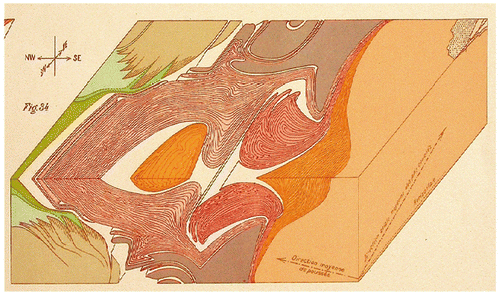
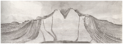
Figure is a diagram that the great genius of Alpine geology, Émile Argand (1879–1940) had drawn in 1906, before he finished his doctoral dissertation mapping. Figure shows his dissertation map (Argand, Citation1908), a magnificent (and now classic) feat of high mountain mapping. Figure shows his well-known block diagram of the internal structure of the western Alps (Argand, Citation1911, Citation1912). We also know that even before he started mapping in his field area around Zermatt, he had astonished his future teacher Maurice Lugeon (1870–1953) with his amazing interpretative sketches of the Alps that he had climbed as a mountaineer (Lugeon, Citation1940, p. 26). The lesson is: Argand had thought about what he was seeing on outcrop in the light of what he had read about them. He went to the field with a hypothesis based on his previous vast reading with a view to guiding his mapping and to filling in the gaps the previous field observations inevitably would have left. Argand then tested his own ideas that he had generated to fill in the gaps in his observations by making deductions from the observations. In the space of an amazing five years, he sorted out the until then enigmatic structure of the Pennine nappes, a feat undertaken with a knowledge and memory, which, Albert Heim (1849–1937), the grand old man of Swiss geology in the beginning of the twentieth century, found ‘unfathomable’ (Heim, Citation1922, p. v-vi). We know that Argand’s ideas continued to evolve, including drastic changes in interpretation, at least until Citation1936 (see also Argand, Citation1924), four years before his death (Şengör, Citation1982c).
Figure 1. The stereogramme of the western crystalline Alps showing the giant nappes of the Pennine Zone, then called the Piemonte Zone by Émile Argand, showing only the upper surfaces of the pre-Triassic rock assemblages. This magnificent figure was drawn by Argand on 18 February 1906, three years before his doctoral dissertation was published and a year before his mapping of the Dent Blanche area was completed, but he never published it; it was drawn simply as an aid to develop his thinking (copied from Schaer, Citation1998, Figure 23, with permission).
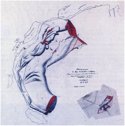
Figure 2. Émile Argand’s great map of the Dent Blanche and surroundings which formed a part of his dissertation mapping. The pink-red areas correspond with the Lower Austroalpine Dent Blanche Nappe floating on the ophirags and the schistes lustrés of the Pennine zone (greens and blues). The entire ensemble rests on the giant body of the Grand St. Bernard nappe (see Figure ). This map was published by the Swiss Geological Commission, as issue XXIII, map No. 32 in 1908.
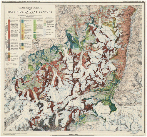
Figure 3. Argand’s famous block diagram showing how the axial plunge southwestward reveal the deep structure of the Pennine Nappes (Argand, Citation1912). Notwithstanding the enormous progress made in the techniques of deep imaging, not much has changed in our ideas concerning the structure of the Western Alps since Argand first laid it bare before the astonished eyes of the world geological community in 1911.
Similar observations can be made about Eduard Suess’ (1831–1914) work, possibly the greatest geologist who ever lived: Some of his field sketches in his field notebooks betray what he had in mind and when one reads his interpretations later, one realizes what remained of his original thoughts and what changed (see, e.g. his magnificent panorama of the Etna and what he then called the western ‘marginal zone’ of Sicily in Suess, Citation1874: see Suess, Citation1872; Citation1873, Citation1874, Citation1875, Citation1885 to follow the changes in his interpretations; he had changed his mind already in 1885 when he finally considered the Sicilian tectonic zones simply a continuation of the Apennines; his publications between 1872 and 1885 show the steps by which that change came about). A reading of his tectonic publications between 1873 and 1913 (i.e. one year before his death) reveals how much he repeatedly generated new ideas and tested them against observations (by himself or by others). Sometimes he went back to his original outcrops to look at them in the light of new ideas and changed his interpretations accordingly (see, for example, his two contrasting view of the batholiths of the Erzgebirge: Suess, Citation1883, pp. 218–219; Citation1909, pp. 633–634). At every stage, it is easy to follow what Suess was saying, because every time he presented a model that one was able to let evolve in a continuous fashion in time and space. The model ‘worked’ in his readers’ mind (that does not imply that it was ‘right’). That enabled his reader to test it by seeing whether, as it worked, it violated any other geological relationships around it.
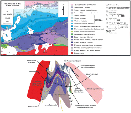
Figure shows my own mapping in the Albula Pass area of the Lower and Middle Austroalpine Nappes in the Swiss canton of Graubünden. This is the first map of the area in which a structure cannot only be seen, but can be retro-deformed continuously in a tectonic framework of extensional tectonics first and then shortening generating nappes with all their internal structures. That interpretation is in harmony with what is known from the immediate surroundings of my area and with the entire Alpine structure, plus with the general tectonic processes known to us today. My basic principle has been not to draw any fault anywhere in my map until no other interpretation was possible, simply because a fault severs geological continuity. Unless it is absolutely unavoidable to assume a break in continuity, I decided to stick to continuity, because it is more easily testable and refutable. Figure shows the result, which is a structural interpretation. All older generation maps of the Albula Pass area had identified numerous independent fault-bounded packages, later, slices, following whatever the fashion of the day was. Everytime the result was a chaos that could not be reconstructed to its initial state. Those older maps could not fill in the blanks that Nature had left for us to fill in. Being parsimonious with faults is thus a hypothesis that is more easily refutable than that invoking discontinuities.
Figure 4. (a) Geological map of the Albula Pass area from my dissertation in the canton of Graubünden, eastern Switzerland. This map omits the outcrops for clarity of presentation, but the original dissertation map displays them. (b). The structural interpretation of the Albula Pass area. It is much more detailed than the interpretation I was able to give in my dissertation. The red dashed line is the axis of F-1 folding that was probably synchronous with the D-1 thrusting. The yellow dashed lines are F-2 folds. The black dash-dot lines are thrust boundaries with sense of original motion indicated by arrows.
What I did, in a nutshell, was to attempt to reconstruct the ‘organs’ of the Alpine orogen properly as exposed in my area in discontinuous outcrops (note the incompleteness of my data!), so that they would fit into the rest of the Alpine ‘machine’ to enable it to function. Many of my steps remain hypothetical, ‘the best guess’, but they are also testable.
Terranology: the baconian disease
In the 80s of the twentieth century, a new fashion irrupted in the North American Cordillera: terranology. It was thought that the interpretations of orogenic belts that had immediately followed the rise of plate tectonics had not done justice to the complexity mountain belts displayed. It was argued that genetic connections had been assumed where they could not be rigorously demonstrated and that, it was argued, had done much harm to our understanding of orogenic processes. What was instead recommended was to define ‘terranes’, i.e. fault-bounded entities with geological histories different from their surroundings and to disclaim any knowledge of what the relation across the mute fault-bounded margins were (or may have been) until they were ‘proven’ (see Şengör, Citation1990, for references to the ‘founding papers’ of terranology). It was not realized that by introducing discontinuities into areas of uncertainy, one also reduced the possibilty of testing the interpretation of the nature of the areas wherever uncertainties arose.
The term ‘terrane’ in this sense was introduced by the US Geological Survey geologist William ‘Porter’ Irwin in 1972 (Irwin, Citation1972, p. C103) for the previously much more informative term thrust-fault-bounded fault block (cf. Hershey, Citation1906, p. 58)Footnote2, which Suess, (Citation1909, p. 481) interpreted, I believe correctly, as Schuppen, i.e. imbricate packages. Irwin’s ‘new’ manner of thinking quickly turned tectonic maps into potato pots (cf. Irwin’s terrane map of the Klamaths in Irwin, Citation1972, Figures through : the boundaries between his ‘terranes’ are mute, i. e. they give no information as to what sort of structures they may be, thus representing a significant step backward from Hershey’s interpretations of more than half a century earlier, because Porter’s map is less testable than Hershey’s)!
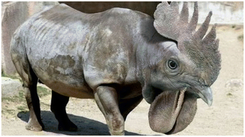
Figure 5. An impossible animal, with a massive body, hooved feet and a beak, produced using photoshop (from the site http://galeri.haberturk.com/komedi/galeri/426779-siradisi-hayvanlar!). However ‘convincing’ it may look, it would have been easy for Cuvier to declare it a fake. In numerous geological publications today, one encounters tectonic reconstructions as impossible as this zoological reconstruction.
I originally chose to ignore that new development, thinking that such an obvious fallacy would soon blow over, but when it instead started becoming a much admired fashion making headways in places other than the North American Cordillera, I was alarmed and wrote a detailed critique (Şengör, Citation1990). My teacher and friend Professor John F. Dewey shared my misgivings and joined me in a different version of the same sort of critique during a meeting on terranology we had organized together with the late Ian Gass, Gordon Curry and Nigel Harris under the auspices of the Royal Society in London (Şengör and Dewey, Citation1990).
In our critiques, we pointed out that data in geology are habitually incomplete by a large percentage. Dewey, in a seminal paper (Dewey, Citation1975a), had demonstrated that plate tectonics had shown us how and why our data-set in orogenic belts not only is, but must by nature be, woefully inadequate and unique reconstructions of orogenic events are usually simply impossible (see also Dewey, Citation1975b, Citation1976). Good interpretations required testable models based on a detailed knowledge of the processes.
Cuvier’s great lesson in historical geology
So what are we to do? How are we to make models from incomplete data concerning unique events? In answering this critical question, I wish to remind my readers that many geologists seem to have forgotten the lessons we had learnt from George Cuvier (1869–1832) at the end of the eighteenth century. Cuvier was keen to test George-Louis Leclerc, Comte de Buffon’s (1707–1788) theory of the development of the animal world through geological time (Buffon, Citation1778). One important component of that theory was that the mammoths and the wooly rhinoceros cadavers found almost complete in the frozen ground of Siberia were of the same species of the elephants and rhinoceroses now living in the southern parts of Asia. So, he set to work with his friend Étienne Geoffroy Saint-Hilaire (1772–1844) and demonstrated, mainly on the basis of molars, that the mammoths, African and Asian elephants all belonged not to the same species as de Buffon’s theory required, but to different species (Cuvier and Geoffroy Saint-Hilaire, Citation1795; Cuvier, Citation1796; since 1827 we have known that they even belong to three different genera). They also showed that mammoths belonged to an extinct species, thus proving, for the first time definitively, the reality of the extinction of animal species. Cuvier was excited by this discovery, because he realized that fossils could provide a much more reliable tool for establishing relative positions (and thus ages) of sedimentary rock bodies. When he told his friend, the great mineralogist and the director of the Sèvres porcelain factory (founded in 1756), Alexandre Brongniart (1770–1847) about this, Brongniart replied by telling him of the numerous fossil bones in the gypsum quarries of Montmartre (a 130 –meter high hill carrying the great basilica of Sacré Cœur at its summit; it is now within the city limits of Paris, forming a part of the 18th arrondisement on the right bank). Cuvier wanted to see them and Brongniart took him there.
The bones were indeed there, but not all in articulated skeletons. The problem was now to find a way to reconstruct the owners of the bones. It became quickly clear that not all animals represented by the bones had left all of their bones behind. Cuvier had to work from not only thoroughly jumbled up, but also incomplete, materials.
It was in generating the methodology of reconstructing former quadrupeds from inarticulate and incomplete osteological material that, now everybody agrees, Cuvier’s genius reached its highest pitch: the great zoologist had already realized, following Aristotle, that every animal was a complete machine with a design to accomplish certain tasks. Such ‘animal-machines’ consisted of parts and every part had a function of its own. This inspired Cuvier to ideas on what we today call ‘functional morphology’ (see Cuvier, An 6 [Citation1798], chapter II; Cuvier, Citation1819, pp. 1–56). For example, sharp canines were used to tear flesh, whereas blunt and broad molars to grind plant material. Hooves were useful for running, whereas paws, armed with claws, were useful both for running and tearing. From this, Cuvier concluded that an animal with sharp canines would be expected to have paws and not hooves, whereas those with sharp frontal cutting teeth and broad molars would be likely to have hooves to enable these presumably herbivorous animals to run away from predatory carnivores. Similarly, beaks were associated with anisodactylic, zygodactylic, heterodactylic and syndactylic clawed feet. From such associations, Cuvier deduced his famous law of correlation of parts: No one animal could have a beak and hooved feet in the same body (cf. Figure for the representation of such an ‘impossible’ animal). Similarly, no animal can have paws and broad molars and frontal cutting teeth and no canines. Multiplying such correlations, Cuvier quickly was able to tell which bones had to go with which other ones. This, combined with his unparalleled knowledge of the quadruped skeletons in the animal kingdom (to appreciate the basis of his knowledge, one should visit his immense collection of skeletons representing the entire spectrum of the quadrupeds in the Palaeontology building of the Muséum National d’Histoire Naturelle in Paris), he unhesitatingly reconstructed, from incomplete materials, quadrupeds that no one had ever seen before (Cuvier, Citation1812). When he was presented with the fossil of a skeleton with wings, which most people were inclined to see as that of a bird or a bat, a glance at its skull told Cuvier that it was a reptile capable of powered flight (Cuvier, Citation1809)! Part of a tiny bone protruding from a gypsum hand specimen led the great anatomist to declare the owner an American marsupial rat (genus Didelphys). He even predicted where the epubic bone was to be found, if the preservation was complete. Challenged to demonstrate it, he prepared the fossil with a needle and, before the astonished eyes of his colleagues, indicated with a red ‘x’ where the epubic bone had appeared (von Zittel, Citation1899, p. 194; that historic specimen is now amongst the most treasured pieces of the collections of the Muséum National d’Histoire Naturelle in Paris).
Cuvier’s law of correlation of parts is only a special case of Leibniz’s (1646–1716) idea of compossibilty: only those things can exist together if it is possible for them to coexist (see Russell, Citation1945(1972), p. 594). This is also precisely the same idea that Empedocles (c. 490–430 BCE) propounded when he pointed out that not all combinations of previously individually created organs were possible. His word for compossibility was ‘love’ (see Guthrie, Citation1965(1980), pp. 200–216).
Armed with Cuvier’s laws and rules constituting what we now call comparative anatomy, some of his successors such as Othniel Charles Marsh (1831–1899) and Thomas Henry Huxley (1825–1895) had already surmised that the therapod dinosaurs were most closely related to birds, an astonishing hypothesis that found its resounding corroboration in the late twentieth century work on such fossils as Compsognathus longipes (Ostrom, Citation1978) and Archaeopteryx lithographica (CitationOstrom, 1976) and the Chinese feathered dinosaurs that ended up showing that birds are simply therapod dinosaurs (e.g. Lucas, Citation2007).
Cuvier’s lesson was immortal: history is as much a science as physics or chemistry. Like them it works on incomplete evidence and tries to reconstruct nature on the basis of conjectural, hypothetical laws we erect temporarily until we find better ones. We complete in our mind’s eye our incomplete evidence in the light of our laws. We do not trust our laws, we never forget that they are our mind’s creation and are not necessarily in Nature, and we try to test them at every step. History cannot be content at simply describing the extant evidence. It has to go beyond to complete reconstruction knowing that it can only be a conjecture, but one that is informed by our laws and inter-subjectively testable (cf. Şengör, Citation2001). For such reconstructions as complete a data-set is a requirement and models with which to compare the finished reconstructions. The resounding success of Cuvier’s vision was Charles Darwin’s theory of natural selection (Darwin, Citation1859).
Comparative anatomy of mountain belts
Based on similar considerations, tectonicians began very early to recognize individually functioning entities (such as folds, faults and intrusions) in mountain ranges that as a whole appeared as machines undertaking certain tasks. This awakened the hope that a ‘comparative anatomy of mountain belts’ may be possible. Tectonicians’ problem was somewhat different from Cuvier’s, however, because the ‘task’ of a mountain range, unlike that of an animal, is not obvious at a first glance and needs to be deduced from its ‘organs’ (only the uplift function appeared very probable since antiquity owing to marine fossils found on mountain tops; the uncertainty in this inference resulted since the days of the Ionian naturalists in the sixth century BCE from not knowing whether sea level has been fixed or not through geological time: see Şengör, Citation2003). The task of reconstructing the structure and hopefully also the history of a mountain belt required that its organs be properly identified first and then their functions and mutual relationships be established, which, one hoped, would yield the ‘task’ and the ‘mode of function’ of the mountain chain as a whole.
At first, it was thought that volcanoes were good analogues of mountain chains and the differences between the two were thought simply that the former was axisymmetric, whereas the latter had a bilateral symmetry about an organ of ‘uplift’. This was the influence of Hutton’s (1726–1797) great triumph over the neptunists in showing that granite was intrusive (which was justified) and that it uplifted its superjacent rocks into domes or pierced cones (which was not justified) as famously illustrated for him by his talented and polymath friend John Clerk of Eldin (1728–1812; see Figure : Craig et al., Citation1978)Footnote3.. The great German geologist Leopold von Buch (1774–1853) and the Swiss master Bernhard Studer (1794–1887) took various igneous and metamorphic rocks for intrusive and held them responsible for uplifting mountains (von Buch, Citation1824; Studer, Citation1834, especially the Introduction). In his Geologie der Westlichen Schweizer-Alpen, Studer (Citation1834) displayed the Alps as a symmetric chain with a central ‘active’ crystalline axis and two flanking passively uplifted and folded sedimentary zones and considered the historical origin of such volcanoes as Monte Nuovo between 29 September and 6 October 1538 in the Phlegraean Fields in southern Italy as ‘laboratory experiments’ illustrating how the large mountain ranges such as the Alps had formed (see his p. 2).
Figure 6. A cross-section across the island of Arran in Scotland drawn by John Clerk of Eldin showing the intrusive nature of the central granite and the ‘uplifted’ rocks surrounding it (copied from Craig et al., Citation1978, with the kind permission of the late Sir John Clarke of Penicuik). The only thing in this cross-section that stood the test of time is the intrusive nature of the granite and the dykes. The simple uplift structure of the country rock and the disappearance of the unconformities away from the central uplift eventually proved to be wrong.
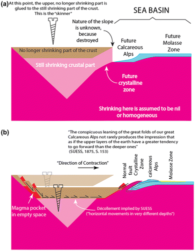
This model collapsed when the Rogers brothers showed in 1843 that the Appalachians had an asymmetric structure and betrayed considerable horizontal movement northwestward with respect to the interior of the continent (Rogers and Rogers, Citation1843). James Dwight Dana (1813–1895) took their ideas and generalized them within the context of Élie de Beaumont’s ideas on what Dana was later to call geosynclines and Élie de Beaumont’s contraction theory (Élie de Beaumont, Citation1828a, Citation1828b; Citation1829; Dana, Citation1846, Citation1847, Citation1863), but it was Suess, who in Citation1875 really changed our views of the anatomy and evolution of mountain ranges. He began by showing, in agreement with the Rogers brothers, that the mountain ranges were all asymmetric and that their external zones, i. e. the region towards which the main upper plate transport in the entire orogeny was directed, showed great structural and stratigraphic continuity along the strike. Internal zones were more complex. Their crystalline zones were, however, not agents of active uplift, as previously believed, but instead passive metamorphic rocks created during orogeny. The innermost zones were either extensional in character (Carpathians, Appenines) or had backfolding associated with them (Alps, the Altaids). In front were foredeeps; in the back, commonly (but not invariably), backdeeps. Fore and hinterlands deformed in a brittle, non-penetrative fashion synchronously with the mountain belt itself. Figure shows my interpretation of Suess’ ideas on orogeny from his writings (Suess, Citation1873, Citation1874, Citation1875, Citation1883–Citation1909, Citation1886, Citation1913).
Figure 7. Eduard Suess’ interpretation of orogeny as expressed in the Central and southern European mountain ranges. (a). Pre-orogenic stage. The shape of the still shrinking part of the earth was unknown, but postulated to have a conical form with an apex pointing downward. The gluing of the no longer shrinking part to the shrinking substratum in a limited area is required by Suess’ postulate of the ‘different depths of deformation’ and his observation that in some orogenic belts the interior of the mountain belt subsided along normal faults, creating basins, and produced magmatism, while shortening was going on in the exterior part as expressed by continuing forefolding. (b). Orogeny: contraction of the still shrinking part shown in Figure 7 not only causes the non-contracting upper part of the crust to subside, but the off-centered gluing of it to the still contracting part propels it to the right creating shortening in the exterior, but extension in the interior part of the orogenic belt. This direction of motion of the no longer contracting upper part is what Suess meant by ‘direction of contraction’ in his writings. This is a very different picture of orogeny via contraction from those of Élie de Beaumont, James Dwight Dana and later Leopold Kober and Hans Stille, who tenaciously stuck to Élie de Beaumont’s analogy of the jaws of the vise squashing a part of the crust between them creating symmetric orogens, although it was so obviously in contradiction with the observations in Europe and in the Appalachians. Later Suess realized that both the Caledonides and the Cordillera of the Americas had a symmetric structure. Only with plate tectonics we have come to recognize that the Caledonides really consist of two oppositely facing Cordilleran orogens that collided and that both the North and the South American Cordillera have a fundamentally asymmetric structure (the well-developed hinterland fold and thrust belts along the entire Cordillera give the impression of symmetry, but it is a pseudo-symmetry).
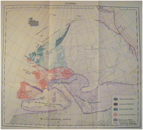
Because Suess sought continuity both in space and time of mountain belts and their formative processes, he became interested in delineating ‘trend-lines’. By trend-lines (Leitlinien in the German original, translated as lignes directrices into French), Suess meant the lie of the trend of fold axes, strike directions of beds and schistosity and main faults in any deformed area (see Suess, Citation1883, p. 302, for his clear definition). For the usage of this concept in pre-plate tectonic context, see Bertrand (Citation1897, p. X), Chamberlin (Citation1924), Ampferer (Citation1938) and Kraus (Citation1949). For its — I believe entirely unjustified — criticism, see Tietze (Citation1917, pp. 333ff.) and Stille (Citation1927, pp. 1–9). As Bertrand (Citation1897) rightly emphasized, it is an extremely useful concept, unfortunately too little used today, except in geological mapping by some structural geologists under the designation ‘form surfaces’ in English (see an excellent presentation of this technique in Hobbs et al., Citation1976, pp. 365–370, esp. Figure 8.15; what Suess was doing was essentially form surface mapping on a continental scale! For another, graphic display of form surface mapping on a continental scale, see Stille, Citation1924, Figure 24. Wegener, in his unpublished sketches, also used form surface mapping on a continental scale to check his reconstructions: see Alfred-Wegener-Institut für Polar-und Meeresforschung, Citation2005, p. 144). This gave Suess an immensely powerful tool in interpreting the structure and history of entire continents. Figure shows his tectonic map of Europe as an example.
Figure 8. Suess’ tectonic map of Europe showing the three major orogenic systems that he recognized in 1886. This map was published in Suess (Citation1893).
Tectonics disintegrated after Suess, because the horizontal motions he postulated were thought unreasonable (Şengör, Citation1982a, Citation1982b). Few of his followers such as Frank Bursley Taylor (1860–1938) and Émile Argand had little actual influence (although it became very proper and learned to revere and cite Argand, it did not seem equally necessary to understand what he actually had said). With such reactionary tectonicians as Émile Haug (1861–1927), Leopold Kober (1883–1970), Stille (1876–1966), Walter H. Bucher (1888–1965) and Nikolai S. Shatsky (1895–1960), the world of tectonics went back to Élie de Beaumont and Dana and every continent became a unit in itself with hypothetical orogenic rings that could not stand even the simplest tests (which were never suggested, let alone performed; the geology of the oceans was almost wholly unknown, but this bothered nobody until Maurice Ewing {1906–1974} decided that it was silly to go on talking about the face of the earth while knowing essentially nothing of the 7/10’s of its surface: see Bullard, Citation1977, p. iiiFootnote4.). Tectonics slowly drifted away from explanations and mute tectonic units multiplied becoming entities unto themselves with no connection with their neighbors or any other tectonic unit. Geologists mapped and interpreted their favorite little gardens, and inter-garden correlations were shunned as idle speculation and as straying from field data. J. Tuzo Wilson (1908–1993), the man who invented plate tectonics thereby saving geology from descending into a collector’s vocation, wrote in his autobiographical prefatory chapter in the Annual Review of Earth and Planetary Sciences the following: ‘My courses in physics and chemistry showed me that science could and indeed should have precise theories, but at that time geology lacked them and all right-minded geologists scoffed at the search for any. They said this was armchair geology and that more maps were both the aim and the method of geology’ (Wilson, Citation1982, p. 6). If we compare this state of affairs with the zoology of Cuvier’s times, most of the geologists of the twentieth century seem to have returned to the pre-Cuvierian days of their science. They began inventing horses without heads or cows without horns, simply because they could not find the heads or the horns in their back yards that they were studying. A skeleton of a horse without the head became a new horse species that somehow managed to do without a head! Mindless empiricism was not only practiced but also recommended as the only proper way of doing geology during the 1924–1965 interval, which I elsewhere called the ‘dark intermezzo’ (the time between Argand’s great classic, La Tectonique de l’Asie and the invention of plate tectonics by Wilson in 1965: see Şengör, Citation1998; Şengör and Bernoulli, Citation2011). Baconianism became the last refuge of the ignorant.
Isotopic dating being pressed into service to smuggle inappropriate tectonic interpretations into publication
I claim that the Baconian attitude of the Dark Intermezzo has now returned with a vengeance, after the spectacular successes of plate tectonics had given way to a period of its detailed applications, eventually culminating in terranology; and terranology found a most unlikely – and actually entirely innocent – accomplice: reliable, accurate isotopic dating, especially of zircons. A most welcome method, capable of yielding the greatest clues to our understanding of the behavior and the history of our planet, thus became an involuntary accomplice in scientific humbug perpetrated by many using the results of isotoping dating as a means to get papers published that otherwise would find it hard to pass good reviewers, because it is now so easy to rush into the field with any kind of geological map one can find, to spot the suitable rocks that might yield a sufficient quantity of zircons, to collect their zircons and to have them dated. Once the dating is done – in itself an extremely useful thing to do – one begins looking around to see what other similar dates are available in the immediate surroundings, or in the larger surroundings, or in the world. One draws circles around similar-aged ‘terranes’ and declares them to have been at one time together, or near, or whatever, with no regard to whether suitable geological structures are there to accomplish what is postulated. Thus, chronology of local rock masses alone is deemed sufficient to make tectonic interpretations. Because good isotopic ages are such valuable observations, whatever a paper containing them says apart from them is ignored and the paper is published just to make the good ages available to the geological public. It is regrettable that apart from the people who actually work in the area reported in such papers, the rest of the geological community takes the good ages together with the bad other kinds of data (structural, sedimentoloigcal, etc.) and/or interpretations. This, naturally, leads to much confusion in the end.
In the Altaids, for example, numerous papers have been published since Şengör et al.’s (Citation1993b) synthesis, claiming drift and collisions of numerous terranes without demonstrating the presence of a single structure that might be expected in a collisional mountain belt. I shall here give one example from the Altaids: Kröner and his co-workers (Kröner et al., Citation2005; I chose this particular reference because it is an easily read extended abstract nicely summarizing and referencing other papers on which it is in part based) have published a very large number of zircon ages from the Altaids in numerous papers. They claim that these dates disprove the model earlier presented by Şengör et al. (Citation1993) and Şengör and Natal’in (Citation1996). Now what do they have to show for their claim: Nothing but isotopic ages – which are, by the way, mostly in agreement with the predictions of the model published by Şengör et al. (Citation1993) and Şengör and Natal’in (Citation1996) – with no mapping-based synthesis. For example, they state for Mongolia ‘Oceanic crust and island arc formation was still active in central and southern Mongolia in Carboniferous to earliest Permian time (Tomurtogoo, Windley, Kröner, & Liu, Citation2004, and new SHRIMP ages) that we ascribe to opening and closure of the Mongol-Okhotsk ocean, and granitoid magmatism is documented by ∼300–290 Ma granites in the Tseel Terrane of the Gobi Desert.’ The ages cited are in the same interval as those that Şengör and his co-workers had gathered from earlier published literature and the only different thing in Kröner et al.’s model is the claim that the Mongol-Okhotsk ocean ‘opened and closed’ during the time interval indicated. Is there any evidence cited apart from the ages? None. Are ages sufficint evidence? Certainly not. Şengör and his co-workes have clearly shown that the Mongol-Okhotsk Ocean did not close until the end of the Jurassic using not only age but also stratigraphic, structural and petrographic data, and their conclusion is corroborated by more recent palaeomagnetic observations (Kravchinsky et al., Citation2002).
Strangely, Kröner et al. conclude that they discard the Şengör et al. model, but that they use a southwest Pacific model: ‘Our data do not support evolution of the CAOB [Central Asian Orogenc Belt: an inappropriate designation for the Altaids: see Şengör and Natal’in, Citation2007] from a single, long-lived arc system as proposed by Sengör et al. (Citation1993) but suggest a setting similar to the present southwest Pacific.’ But is that not precisely what Şengör et al. said and drew in their papers? In fact, does southwest Pacific not display the history of a ‘long-lived arc system’? The apparent numerous subduction zones shown in many publications at the surface there have no expression at depth as they are nothing more than shallow retrocharriage systems to the main subduction zone, except the Northland-New Caledonian subordinate subduction zone (Schellart et al., Citation2009). Did Şengör et al. not indicate a similar, local, double subduction zone akin to the circum-Fiji subduction zones (see Schellart et al., Citation2009, esp Figure 1 and compare it with Figure 21.30 in Şengör and Natal’in, Citation1996, showing the Boschekul-Tarbagatay double arc and Dzhezkazgan-Jalair double arc during the late Cambrian). A glance at the evolutionary maps by Seton et al. (Citation2012, Figure 3) would show a single arc in the southwest Pacific, the Solomon Islands ridge and its westerly continuation much like the Kipchak Arc of Şengör and his co-workers, moving away from Australia, and not a herd of terranes, as Kröner and his co-workers seem to believe, from 40 Ma to the present. The subduction flip seen in the southwest Pacific is also seen in the Kipcpak Arc history as documented in Şengör and Natal’in (Citation1996; see Figures 21.22 and 21.23 around the Atasu-Mointy pre-Altaid continental sliver). Finally, the history of subduction in the southwest Pacific is one of a single major subduction zone at any one time since 180 Ma ago (Seton et al., Citation2012, Figure 5). It should not be forgotten also that numerous major subduction zones in a single ocean are likely to induce unrealistically high plate motion rates.
Kröner et al.’s confusion comes from the fact that they not only seem not to know the details of the geology of the southwest Pacific, which, albeit very complicated, is still dominated by a single arc system accompanied by much arc-subparallel strike-slip, but also they themselves have no continuously retrodeformable tectonic model. They clearly reuse what Şengör et al. (Citation1993) and Şengör and Natal’in (Citation1996) had published, but claim they do not, because they confuse the archipelago they see on the surface in the southwest Pacific (which they seem to interpret as independently moving ‘terranes’) with the single major subduction zone that governs their origin and motion precisely similar to Şengör et al.’s Kipchak Arc. What is, of course, of interest is that palaeomagnetic observations have since spectacularly corroborated the Şengör et al. (Citation1993) and Şengör and Natal’in (Citation1996) single dominant arc model for the Kipchak arc (Collins et al., Citation2003; see summary in Van der Voo, Citation2004; more recently Alexyutin et al., Citation2005, may have corroborated the sinistral strike-slip postulated by the Şengör et al., Citation1993 and Şengör and Natal’in, Citation1996 model through the anti-clockwise rotation with respect to the Russian Craton that they report for parts of the Chu-Ili and Kendyktash Mountains close to major straight fault zones; because their study is not accompanied by detailed local structural data, it is impossible to be sure of the implications of the palaemagnetic data).
Kröner et al. (Citation2005) state in addition for Mongolia, for example, that they have discovered much older material using the isotopic signatures. But Şengör et al. (Citation1993) and Şengör and Natal’in (Citation1996) already reported these older basements and called them collactively Tuva-Mongol continental basement. On the basis of this, they claimed two separate arcs, the Kipchak and the Tuva Mongol, not a single arc for the entire Altaid supororogenic complex as Kröner et al. try to put into their mouths. Kröner et al. criticize a non-existent claim, simply because they have not read with any care the geological literature they set out to criticize.
With the great quantity of new age data at their disposal, Kröner et al. therefore have not improved our understanding of the Altaids by one iota, simply because they did not consider their data in the light of the geological structures in the field and of appropriate tectonic analogues. It turns out that the analogue they cite is identical to what they claim to refute. The contribution of their papers remains confined to the reported new isotopic ages from spot locations for which we are all grateful. But the confusion created by their entirely unfounded claims on tectonic evolution, by not thinking about what is compossible in the world of tectonics and what is not (for example are head-on collisions possible by not creating flexural foreland basins atop the understhursting entity), or by repeating what has already been said and claiming them as new discoveries largely result, I think, because of the cavalier fashion they treated the geology of the Altaids and the literature about it. It is against this sort of geologising that this paper is directed.
Unfortunately, a similar development now threatens to render the entire Hercynian/Appalachian and the Eastern Mediterranean Tethyside regions unintelligible. Just one example from the latter: Topuz et al. (Citation2012) recently claimed that the Cimmerian continent did not exist in northern Turkey because they could find no “continental basement” between the Palaeo-Tethyan and Neo-Tethyan accretionary complexes that they had dated. When one reads their paper, one realizes that by continent they mean an ancient gneissic/granitic basement. It seems not to have occurred to them that a continent may consist of previous subduction-accretion complexes. They also completely ignore sedimentological data showing underwater rift development between the two episodes of subduction they recognize (which had been already recognized by Şengör et al., Citation1980, and Şengör and Yılmaz, Citation1981, and later corroborated by Görür et al. Citation1983, on specific sedimentological data, providing details of the rifting process that led to the opening of the northern brach of the Neo-Tethys south of the Cimmerian Continent) that are detrimental to their claim. Their new isotopic age data are most welcome additions to our database, but their tectonic interpretations cannot be regarded seriously, because simple geological notions such as that continental crust may be made by subduction-accretion processes seem unknown to them.
They also seem to have overlooked the full implication of the following statement by Şengör et al. (Citation2005, p. 50): ‘The Tethyside accretionary complexes housing the NASZ belong both to the Cimmerides and to the Alpides.We have drawn no boundary to distinguish the two groups because the Cimmerian Continent that separated Paleo-Tethys from Neo-Tethys has been extremely dismembered and reduced in width in Turkey by both the Cimmeride and Alpide collisional deformations. In places it is now completely absent, where, consequently, Cimmeride and Alpide accretionary complexes directly abut each other ‘. Thus, there really are places in northern Turkey where the Cimmerian Continent is now absent (so their observation is in principle not new), but this is because of secondary removal by subsequent strike-slip faulting. Topuz et al. (Citation2012) consider this possibility and cite Şengör et al. (Citation2005), but seem to think that only a single big strike-slip fault can accomplish continental elision. Had they looked at Şengör et al. (Citation1993), they would have seen what a set of conjugate strike-slip faults can do in eliding large sections of colliding continents. But, they clearly have paid no attention whatever to the larger tectonic framework of northern Turkey and to that in areas similar to it (such as the Himalaya: see Şengör et al., Citation1993) while dating their samples! I am not saying that the suggestion of Şengör et al. (Citation1993) or any other model must be right, but they deserve testing carefully. Topuz et al.’s (Citation2012) new discoveries are important additions to our knowledge, but had they set them in an appropriate geological setting, they would have also increased our understanding.
Despite its serious shortcomings, their paper was published, simply because they provided excellent-quality new age data, but the editors who published their paper did not think of the confusion the paper might create in the minds of their readers who might not be familiar with the local geology and may not be aware of what data may have been left out of the new interpretation. A competent review process might have helped to improve the tectonic interpretation given in the paper.
I shall not get into the North American Cordillera where terranology was born, except to point out that new tomographic work on the North American Cordillera began painting a picture of long, continuous subduction zones, similar to those along the present-day western and southern Pacific (just like the one cited by Kröner et al., Citation2005, allegedly to counter claims on single, long subduction zones!), or to those of the Palaeozoic Altaids, in which long strings of arcs, born close to the continents with which they would eventually collide, dominated the evolution and not a herd of ‘suspect terranes’ stampeding across oceans (Sigloch and Mihalynuk, Citation2013; also see Goes, Citation2013).
Conclusions
The greatest tragedy and danger threatening geology today are that the geologist has begun to praise himself or herself not on account of his or her ability to understand the structure and the history of our planet, but on his or her ability to observe, which, allegedly is proven by his or her ability of listing numbers and statistics. However, if such numbers are not placed in a correct tectonic context, they would be as useful as lottery numbers for understanding Nature. The geologist has quietly renounced the ability to make robust, testable inferences from incomplete data-sets with a view to reconstructing now-destroyed structures and now-silent processes forgetting the truism once expressed in conversation by the late Marshall Kay: “The geologist gets paid not for what he can see, but for what he cannot see.” The geologist has stopped being a scientist and a scholar and become a technician. If the present trend continues, geologists will reduce themselves to robots collecting rocks, handing them to machines and spurting out what the machines list on a printout. Listing numbers and listing terranes and shoving them around on the face of the earth in isolation do not constitute doing geology or tectonic interpretation: they are tools to aid in tectonic interpretation, just as fossils and palaeomagnetic poles by themselves are not sufficient to make tectonic pronouncements. Rob van der Voo’s presidential address to the Geological Society of America was a fine demonstration of how palaeomagnetic data are to be used intelligently in tectonic interpretations (Van der Voo, Citation2004). Studies such as that by Van der Voo and that by Sigloch and Mihalynuk (Citation2013) began to show how Cordilleran orogens evolve along long and persistent subduction zones. Terranologists may wish to read them carefully before they multiply further the wandering potatoes on their maps.
Acknowledgments
The ideas expressed in this paper have been maturing in my mind since my student days, when I began questioning the knowledge and the methods of acquiring it that my teachers were trying to impart on me. Until I became a student of John F. Dewey, Kevin Burke and W. S. F. Kidd, I thought that there was something terribly wrong in teaching geology in much of the world (by that time I had had first-hand experience in Turkey, Germany and the USA). Dewey, Burke and Kidd told me that they shared my views and gave me confidence in them (they taught geology in the way I thought it should be taught). I further discussed these ideas with Daniel Bernoulli, B. Clark Burchfiel, William R. Dickinson, Warren B. Hamilton, Jean-Paul Schaer and the late Rudolf Trümpy with great profit. In Turkey, discussions with İhsan Ketin, Sırrı Erinç, Yücel Yılmaz, Naci Görür, Boris A. Natal’in and Aral Okay helped me sharpen my ideas. I am honoured and pleased that my old friend Erdin Bozkurt invited me to contribute to the special issue honouring my friend and colleague for over 30 years, Aral Okay. I also thank my old-time friend and colleague Professor Alastair H. F. Robertson and another, anonymous, reviewer for two truly critical, penetrating reviews that vastly improved this paper. Alastair was particularly cutting and detailed in his criticisms in his long review, for which I am genuinely grateful. I originally had thought not to name any of the scientists I implicitly criticize, because they are numerous. My reviewers insisted that some examples be given and specific instances be cited to clarify the point the paper attempts to make. The examples I chose happen to be cases that enter into my own area of research, because they are the ones I am closely familiar with. This also enabled me to choose examples in which I criticize the work of close friends, who I know will not be offended. Notwithstanding the great help I received from many people, including my reviewers, I alone am responsible for everything I wrote.
Notes
1. Translation of the mottoes:
Earth, as we see it before us. Here also a genetic view is desirable. Everything, which we see as having formed and we thereby recognise a succession, there we desire to see a stagewise coming-to-be just as true history does not simply present a list of what happened, but lets that which originated evolve successively and describes it thus. (Johann Wolfgang von Goethe)
When the nature of the landscape is depicted in world or country maps, this should always be done with the recognition of the hypothesis in mind as this was expressly done by a Buache, Gatterer, v. Zimmermann, Fr. Schulz, Reichard. This is useful for science, as Zeune has shown from numerous viewpoints. But this usefulness is again lost because of the mindless, blind imitators and in its stead we get only a fragmentary picture of Nature. Physical earth science should reject such pictures as firmy as physiognomy rejects incorrectly drawn silhouettes. (Carl Ritter)
The rupture between man and the earth is at the same time the rupture between man and himself. (Gustave Thibon)
2 Note that Oskar Hershey’s interpretation underlying the terminology he used need not be correct! But his terminology is an interpretative/genetic terminology that would prompt testing and guide further observations. Suess’ terminology is even better. Irwin’s term is purely descriptive and thus sterile.
3. One of the reviewers of this paper, Professor Alastair H. F. Robertson, kindly reminded me that the beds in the northern part of Arran are indeed turned up as John Clerk had drawn them. I visited the area in 1997 under the incomparable guidance of my late regretted friend Professor Donald B. McInyre. The turned up beds are indeed there, but covered unconformably by gently-dipping beds and the unconformity is marked by carbonate-rich ‘cornstone’ which, for a while, made us wonder whether the unconformity was actually a rotated fault. Young and Caldwell’s (Citation2009) and Jutras et al.’s (Citation2011) recent restudy of the area showed that the relationship is indeed unconformable as Hutton had correctly recognised, but the unconformity is a ‘double’ one, separating the upturned Neoproterozoic to Lower Palaeozoic Dalradian rocks from Devonian redbeds and those from Carboniferous layers. The unconformity is masked by the ‘cornstone’ which Jutras et al. (Citation2011) have shown to be a phreatic calcrete hardpan. The position of the gently-dipping unconformable beds indicate, however, that the tremendous uplift implied to be caused by the granite intrusion in John Clerk’s picture is certainly incorrect, as the early Cainozoic granite would have uplifted the Devonian and the Carboniferous rocks as well. So, there, Hutton’s interpretation was wrong.
4. Professor Robertson, in his detailed review of this paper, also objected to the statement that almost nothing was known about the geology of the oceans prior to World War II, citing the British and the German expeditions as examples of earlier work. I disagree (as I am sure Sir Teddy Bullard would have too), because the results of those early expeditions were almost entirely bathymetric; the few dredging results pertaining exclusively to surficial sediments and volcanic rocks. The superb geophysical work of the Dutch on gravity over the deep-sea trenches and on the inclined seismic zones in Indonesia failed to yield a coherent picture even within the Dutch geological community owing to the imprecision of the hypocenter location and the inability of the geological community at large to shed the pernicious influence of the theory of geosynclines (for a full discussion on this topic, see Şengör, Citation1998, pp. 104–114). Ocean islands, including Iceland, were the only places where the geology of the bottom of the ocean became accessible to direct observation, but it remained unclear till the fifties whether they were typical for the rest. Plate tectonics became possible, because suddenly oceanic geology stopped being a terra incognita in the fifties. For an example of how little the geology of the oceans was known, see Stille’s tectonic synthesis, just before the War, of the then best-known ocean, the Atlantic (Stille, Citation1937).
References
- Alexyutin, M. V., Bachtadse, V., Alexeiev, D. V., & Nikitina, O. I. (2005). Palaeomagnetism of Ordovician and Silurian rocks from the Chu-Yili and Kendyktas mountains, south Kazakhstan. Geophysical Journal International, 162, 321–331.
- Alfred-Wegener-Institut für Polar- und Meeresforschung, Herausgeber. (2005). Alfred Wegener Die Entstehung der Kontinente und Ozeane Nachdruck der 1. Auflage mit handschriftlichen Bemerkungen von Alfred Wegener, Notizen und Briefen sowie neu erstelltem Index—Nachdruck der 4. Umgearbaiteten Auflage 1929 mit neu erstelltem Index (pp. 481 SS.). Berlin: Gebrüder Borntraeger.
- Ampferer, O. (1938). Über den Begriff der tektonischen Leitlinien: Sitzungsberichte der Akademie der Wissenschaften in Wien, mathematisch-naturwissenschaftliche Klasse. Abteilung I, 147, 57–69.
- Argand, É. (1908). Carte Géologique du Massif de la dent Blanche (Moitié Septentrional), 1/50.000: Comission de la Carte Géologique de la Suisse, one sheet.
- Argand, E. (1911). Les nappes de recouvrement des Alpes Pennines et leurs prolongements structuraux: Beiträge zur Geologischen Karte der Schweiz Neue Folge, 31, 1–26.
- Argand, E. (1912). Coupes géologiques dans les Alpes Occidentales interprétée par Émile Argand, 1902–1911. Pl 1: Les nappes de recouvrement dans les Alps occidentales et les territoires environnents. Essai de carte structurale, 1:500,000; Pl. II: Neuf coupes à travers les Alpes occidentales, 1:400,000; Pl. III the same; Pl. IV Les grands plis couchés dans les Alpes Pennines, 1:500,000: Mat Carte Géol Suisse, NS 27.
- Argand, E. (1924). La tectonique de l’Asie: Congrés Géologiques International, Comptes Rendus de la XIIme session, Premier Fascicule (pp. 171–372). Liége: H. Vaillant-Carmanne.
- Argand, E. (1936). La Zone Pennique: Geologischer Führer der Schweiz herausgegeben von der Schweizerischen Geologischen Gesellschaft bei Anlaß ihrer 50sten Jahresfeier, Fascicule III Allgemeine Einführungen (pp. 149–189). Basel: B. Wepf & Cie.
- Bertrand, M. (1897). Preface. In E. Suess (Ed.), La Face de la Terre (pp. V–XV.), Vol. I. Paris: Armand Colin.
- von Buch, L. (1824[1877]). Ueber geognostische Erscheinungen im Fassathal. Ein Schreiben an den Gehemrath von Leonhard v. Leonhard’s Mineralogisches taschenbuch für das Jahr 1824. In J. Ewald, J. Roth, & W. Dames (Eds.), Leopold von Buch’s Gesammelte Schriften, (pp. 141–166), Vol. III. Berlin: G. Reimer.
- Buffon Comte de. (1778). Histoire Naturelle, Générale et Particulière, Supplement (pp. viij+615–+xxviij, Vol. 5) Paris: Imprimerie Royale + two foldout tables.
- Bullard, E. (Sir). (1977). Maurice Ewing. In M. Talwani & W. C. Pitman III (Eds.), III, editors, Island Arcs, Deep sea Trenches and Back-Arc Basins, Maurice Ewing Series 1 (pp. ii–iii). Washington, DC: American Geophysical Union.
- Chamberlin, R. T. (1924). The significance of the framework of the continents. Journal of Geology, 32, 545–574.
- Collins, A. Q., Degtyarev, K. E., Levashova, N. M., Bazhenov, M. L., & Van der Voo, R. (2003). Early Paleozoic paleomagnetism of East Kazakhstan: Implications for paleolatitudinal drift of tectonic elements within the Ural-Mongol Belt. Tectonophysics, 377, 229–247.
- Craig, G. Y., McIntyre, D. B., & Waterston, C. D. (1978). James Hutton’s Theory of the Earth: The Lost Drawings (pp. [iii]+67). Scottish Academic Press.
- Cuvier, G. (1796). Mémoire sur les espèces d’Eléphans tant vivantes que fossiles, lu à la séance publique de l’Institut national le 15 germinal, an IV: Magasin Encyclopédique, 2, 440–445.
- Cuvier, G., l’An 6. (1798). Tableau Élémentaire de l’Histoire Naturelle des Animaux: Baudouin (pp. xvj+710). Paris. +XIV plates.
- Cuvier, G. (1809). Mémoire sur le squelette fossile d’un reptile volant des environs d’Aichstedt, que quelques naturalistes ont pris pour un oiseau, et dont nous formons un genre de Sauriens, sous le nom de Ptero-Dactyle: Annales du Muséum National d’Histoire Naturelle, Paris (pp. 424–437. Vol. 13).
- Cuvier, G. (1812). Recherches sur les Ossemens Fossiles de Quadrupèdes où l’On Rétablit les Caractères de Plusieurs Espèces d’Animaux que les Révolutions du Globe Paroissent avoir Détruites (not consecutively paginated). Vol. 4. Deterville.
- Cuvier, G. (1819). Le Règne Animal Disitribué d’Après son Organisation, pour Servir de Base à l’Histoire Naturelle des Animaux et d’Introduction à l’Anatomie Comparée (pp. xxxvij–+540). Vol. I. Deterville.
- Cuvier, G., & Geoffroy [Saint-Hilaire, E.]. (1791–1799 [1795]). Sur les espèces d’Eléphans, par CC. Cuvier et Geoffroy (pp. 90, Vol. 1). Bulletin des Sciences de la Société Philomatique de Paris.
- Dana, J. D. (1846). On the volcanoes of the Moon. American Journal of Science and Arts, 2, 335–355.
- Dana, J. D. (1847). Geological results of the earth’s contraction in consequence of cooling. American Journal of Science and Arts, 3, 176–188.
- Dana, J. D. (1863). Manual of geology: Treating of the principles of the science with special reference to american geological history, for the use of colleges, academies and schools of science (pp. xvi+798). Philadelphia: Theodore Bliss.
- Darwin, C. (1859). The origin of species by means of natural selection, or the preservation of favoured races in the struggle for life (pp. ix+513). London: John Murray. +1 diagram.
- Dewey, J. F. (1975a). Finite plate evolution: some implications for the evolution of rock masses at plate margins. American Journal of Science, 275-A (John Rodgers volume), 260–284.
- Dewey, J. F. (1975b). Plate tectonics. Reviews of Geophysics and Space Physics, 13, 326–332 and 365–367.
- Dewey, J. F. (1976). Ancient plate margins: Some observations. Tectonophysics, 33, 379–385.
- Élie de Beaumont, L. (1828a). Notice sur un gisement de végétaux fossiles de belemnites, situé à Petit-Cœur près Moutiers, en Tarentaise. Annales des Sciences Naturelles, 14, 113–127.
- Élie de Beaumont, L. (1828b). Sur un gisement de végétaux fosilles et de graphite, situé au col du Chardonet (département des Hautes Alpes). Annales des Sciences Naturelles, 15, 353–381.
- Élie de Beaumont, L. (1829). Faits pour servir a l’histoire des montagnes de l’Oisans: Mémoires de la Société d’Histoire Naturelle de Paris (pp. 1–32) Vol. V (extrait).
- Goes, S. (2013). Western North America’s jigsaw. Nature, 496, 35–37.
- Görür, N., Şengör, A. M. C., Akkök, R., & Yılmaz, Y. (1983). Pontidlerde Neo-Tetis’in açılmasına ilişkin sedimentolojik veriler (Sedimentological evidence for the opening of the northern branch of Neo-Tethys in the Pontides). Türkiye Jeoloji Kurumu Bülteni, 26, 11–20.
- Guthrie, W. K. C. (1965(1980)). A History of Greek Philosophy, v. II, The Presocratic Tradition from Parmenides to Democritus (pp. xix+554). Cambridge University Press.
- Heim, A. (1922). Geologie der Schweiz, (pp. 477–1018). Vol. II/2. Leipzig: Tauchnitz.
- Hershey, O. H. (1906). Some western Klamath stratigraphy. American Journal of Science, 21, 58–66.
- Hobbs, B. E., Means, W. D., & Williams, P. F. (1976). An Outline of Structural Geology (pp. xviii–+571). NewYork: Wiley.
- Irwin, W. P. (1972). Terranes of the western Paleozoic and Triassic belt in the southern Klamath Mountains (pp. C103–C111). California: Geological Survey Research 1972. Chapter C. Geological Survey Professional Paper 800-C.
- Jutras, P., Young, P. M., & Caldwell, W. G. E. (2011). Reinterpretation of James Hutton’s historic discovery on the Isle of Arran as a double unconformity masked by a phreatic calcrete hardpan. Geology, 39, 147–150.
- Kraus, E. (1949). Über geotektonische “Leitlinien”. Zeitschrift der Deutschen Geologischen Gesellschaft, 101, 9–22.
- Kravchinsky, V. A., Cogné, J.-P., Herbert, W. P., & Kuzmin, M. I. (2002). Evolution of the Mongol-Okhotsk Ocean as constrained by new palaeomagnetic data from the Mongol-Okhosk suture zone, Siberia. Geophysical Journal International, 148, 34–57.
- Kröner, A., Windley, B. F., Badarch, G., Tomurtogoo, O., Hegner, E., Liu, D. Y., Wingate, M. T. D. (2005). Accretionary growth in the Central Asian Orogenic Belt of Mongolia during the Neoproterozoic and Palaeozoic and comparison with the Arabian-Nubian Shield and the present Southwest Pacific: Geophysical Research Abstracts, v. 7, 06650, 2005 SRef-ID: 1607-7962/gra/EGU05-A-06650, European Geosciences Union.
- Lucas, S. G. (2007). Dinosaurs—The Textbook (pp. XXIII–+280). Boston: McGraw Hill Higher Education.
- Lugeon, M. (1940). Émile Argand: Bulletin de la Société Neuchateloise des Sciences Naturelles (pp. 25–53+1), Vol. 65, portrait+ 5 plates.
- Ostrom, J. H. (1976). Archaeopteryx and the origin of birds. Biological Journal of the Linnean Society, 8, 91–182.
- Ostrom, J. H. (1978). The osteology of Compsognathus longipes WAGNER (pp. 73–118). Vol. 4. Zitteliana, plates 7–14. Munich, Germany.
- Popper, K. R. 1935. Logik der Forschung (pp. vi + 248). Wien: Springer Verlag.
- Rogers, W. B., & Rogers, H. D. (1843). On the physical structure of the Appalachian Chain as exemplifying the laws which have regulated the elevation of great mountain chains generally: Reports of the First, Second and Third Meetings of the Association of American Geologists and Naturalists, at Philadelphia in 1840 and 1841, and at Boston in 1842, embracing its Proceedings and Transactions, Gould, Kendall & Lincoln, Boston, pp. 474–531 (With few corrections, this classic paper was reprinted in Rogers, W. B., 1884, A Reprint of Annual Reports and Other Papers on the Geology of the Virginias: New York: D. Appleton and Company. pp. 601–642).
- Russell, B. A. W. (Lord), 1945 (1972), A History of Western Philosophy: A Touchstone Book (pp. xxiii–+895). New York: Simon & Schuster.
- Schaer, J.-P. (1998). Les Géologues et le Développement de la Géologie en Pays de Neuchâtel (pp. 80). Neuchâtel: IGUN and Muséum d’Histoire Naturelle de Neuchâtel.
- Schellart, W. P., Kennett, B. L. N., Spakman, W., & Amaru, M. (2009). Plate reconstructions and tomography reveal a fossil lower mantle slab below the Tasman Sea. Earth and Planetary Science Letters, 278, 143–151.
- Şengör, A. M. C. (1982a). The classical theories of orogenesis: in Miyashiro, A. K. Akiand A. M. C. Şengör, Orogeny, Wiley, Chichester, pp. 1–48
- Şengör, A. M. C. (1982b). Eduard Suess’ relations to the pre-1950 schools of thought in global tectonics. Geologische Rundschau, 71, 381–420.
- Şengör, A. M. C. (1982c). A note on a late revision of the theory of embryotectonics by Argand himself. Eclogae Geologicae Helvetiae, 75, 177–188.
- Şengör, A. M. C. (1990). Lithotectonic terranes and the plate tectonic theory of orogeny: a critique of the principles of terrane analysis: in Wiley, T. J., Howell, D. G., and Wong, F. L., editors. Terrane Analysis of China and the Pacific Rim: Houston, Circum-Pacific Council for Energy and Mineral Resources, Earth Science Series, 13, 9–44.
- Şengör, A. M. C. (1998). Die Tethys: vor hundert Jahren und heute: Mitteilungen der Österreichischen Geologischen Gesellschaft, v. 89, pp. 5–176.
- Şengör, A. M. C. (2001). Is the Present the Key to the Past or the Past the Key to the Present? James Hutton and Adam Smith versus Abraham Gottlob Werner and Karl Marx in Interpreting History: Geological Society of America Special Paper 355, x+51 pp.
- Şengör, A. M. C. (2003). The Large Wavelength Deformations of the Lithosphere: Materials for a history of the evolution of thought from the earliest times to plate tectonics: Geological Society of America Memoir 196, xvii+347 pp.+ 3 folded plates in pocket.
- Şengör, A. M. C., & Bernoulli, D. (2011). How to stir a revolution as a reluctant rebel: Rudolf Trümpy in the Alps: International Journal of Earth Sciences (Geologische Rundschau), v. 100, pp. 899–936.
- Şengör, A. M. C., Cin, A., & Rowley, D. B. (1993a). and Nie Shengyou. Space-time patterns of magmatism along the Tethysides: a preliminary study: Journal of Geology, 101, 51–84.
- Şengör, A. M. C., Natal’in, B. A., & Burtman, V. S. (1993b). Evolution of the Altaid tectonic collage and Palaeozoic crustal growth in Eurasia. Nature, 364, 299–307.
- Şengör, A. M. C., & Dewey, J. F. (1990). Terranology: Vice or Virtue? Philosophical Transactions of the Royal Society (London), 331, 457–477.
- Şengör, A. M. C., & Natal’in, B. A. (1996). Palaeotectonics of Asia: Fragments of A Synthesis. In A.Yinand M.Harrison, editors, The Tectonic Evolution of Asia, Rubey Colloquium, Cambridge University Press, Cambridge, pp. 486–640
- Şengör, A. M. C., & Natal’in, B. A. (2007). Eduard Suess’ Altaids: what is in a name: in R. Seltmann, A. Borisenk, & G. Fedoseev, editors, Magmatism and Metallogeny of the Altai and Adjacent Large Igneous Provinces with an Introductory Essay on the Altaids: IAGOD Guidebook Series 16. CERCAMS/Natural History Museum. London, pp. 185-294.
- Şengör, A. M. C., Tüysüz, O., İmren, C., Sakınç, M., Eyidoğan, H., Görür, N., Le Pichon, X., & Rangin, C. (2005). The North Anatolian Fault: A new look. Annual Review of Earth and Planetary Sciences, 33, 37–112.
- Şengör, A. M. C., & Yılmaz, Y. (1981). Tethyan evolution of Turkey: A plate tectonic approach. Tectonophysics, 75, 181–241.
- Şengör, A. M. C., Yılmaz, Y., & Ketin, İ. (1980). Remnants of a pre-late Jurassic ocean in northern Turkey: Fragments of Permo-Triassic Paleo-Tethys? Geological Society of America Bulletin, Part I, 91, 599–609.
- Seton, M., Flament, N., & Müller, D.. (2012). Subduction history in the Melanesian Borderlands region, SW Pacific: Eastern Australasian Basins Symposium IV, Brisbane, QLD, 10–14 September, 2012, http://www.earthbyte.org/Resources/Pdf/Seton_Melanesian_borderlands_subduction_history_EABS4_2012.pdf pp. 1–12 (visited on 13th August 2013).
- Sigloch, K., & Mihalynuk, M. G. (2013). Intra-oceanic subduction shaped the assembly of Cordilleran North America. Nature, 496, 50–56.
- Stille, H. (1924). Grundfragen der Vergleichenden Tektonik: Gebrüder Borntraeger Berlin, VIII + 443 pp.
- Stille, H. (1927). Über westmediterrane Gebirgszusammenhänge. In H. Stille, editor, Beiträge zur Geologie der westlichen Mediterrangebiete, I, Abhandlungen der Gesellschaft der Wissenschaften zu Göttingen, mathematisch-physikalische Klasse, neue Folge, v. 12, No. 3, IV+62 pp.
- Stille, H. (1937). Geotektonische Probleme im atlantischen Raume: In Bericht über den Verlauf der 250. Wiederkehr des Tages der Erhebung der am 1. Jan. 1652 Gegründeten Academia Naturae Curiosorum zur “Sacri Romani Imperii Academia Caesareo-Leopoldina Naturae Curiosorum” durch Leopold I. 28. bis 30. Mai 1937, Kaiserlich Leopoldinish-Carolinisch Deutsche Akademie der Naturforscher, Halle, pp. 129–139
- Studer, B. (1834). Geologie der Westlichen Sweizer-Alpen: Karl Groos, Heidelberg and Leipzig, X+420 pp .+ Atlas of 6 plates.
- Suess, E. (1872). Über den Bau der italienischen Halbinsel. Sitzungsberichte der kaiserlichen Akademie der Wissenschaften, mathematisch-naturwissenschaftliche Classe, 65, 217–221.
- Suess, E. (1873). Ueber den Aufbau der mitteleuropäischen Hochgebirge: Anzeiger der Akademie der Wissenschaften in Wien für die Woche von 17. Juli, 1873, 130–131.
- Suess, E. (1874). Die Erdbeben des südlichen Italien: Denkschriften der Kaiserlichen Akademie der Wissenschaften in Wien,34, 1–32, 2 foldout maps (offprint pages repaginated!).
- Suess, E. (1974). Die Erdbeben des südlichen Italien: Denkschriften der mathematisch-naturwissenschaftlichen Classe der kaiserlichen Akademie tder Wissenschaften, v. 34, pp. 1-32 +3 plates
- Suess, E. (1875). Die Entstehung der Alpen: W. Wien: Braumüller . 168 pp.
- Suess, E. (1883). Das Antlitz der Erde, v. Ia (Erste Abtheilung): F. Tempsky, Prag and G. Freytag, Leipzig, 310 SS.
- Suess, E. (1885). Das Antlitz der Erde, v. Ib: F.Tempsky, Prag and G.Freytag, Leipzig, IV+311-778+[1] SS.
- Suess, E. (1886). Über unterbrochene Gebirgsfaltung: Sitzungsberichte der kaiserlichen Akademie der Wissenschaften in Wien, mathematisch-naturwissenschaftliche Klasse, Abteilung 1, v. 94, pp. 111117
- Suess, E. (1888). Das Antlitz der Erde, v. II: F. Tempsky, and G.Freytag, Prag , IV + 704 SS.
- Suess, E. (1893). Ueber neuere Ziele der Geologie. Vortrag, gehalten in der Naturforschenden Gesellschaft zu Görlitz: Abhandlungen der Naturforschenden Gesellschaft zu Görlitz, v. 20, 21 pp. 21 coloured foldout map ( offprint pages repaginated!).
- Suess, E. (1901). Das Antlitz der Erde, v. III1 (Dritter Band. Erste Hälfte): F. Tempsky, Prag and Wien, and G.Freytag, Leipzig, IV + 508 pp.
- Suess, E. (1909). Das Antlitz der Erde, v. III2 (Dritter Band. Zweite Hälfte. Schluss des Gesamtwerkes): F. Tempsky, Wien and G. Freytag, Leipzig, IV + 789 pp.
- Suess, E. (1913). Über die Zerlegung der gebirgsbildenden Kraft: Mitteilungen der Geologischen Gesellschaft in Wien, Bd. I, SS. 13-60 +2 Plates.
- Tietze, E. (1917). Einige Seiten über Eduard Suess—Ein Beitrag zur Geschichte der Geologie: Jahrbuch der kaiserlich und königlichen geologischen Reichsanstalt, v. 66, pp. 333-556.
- Tomurtogoo, O., Windley, B. F., Kröner, A., & Liu, D. Y. (2004). Zircon age and occurrence of the Adaatsag ophiolite and Muron shear zone, central Mongolia: constraints on the evolution of the Mongol-Okhotsk ocean, suture and orogen: Journal of the Geological Society. London, 162, 125–134.
- Topuz, G., Göçmengil, G., Rolland, Y., Çelik, Ö. F., Zack, T., & Schmitt, A. K. (2012). Jurassic accretionary complex and ophiolite from northeast Turkey: No evidence for the Cimmerian continental ribbon. Geology, 41, 255–258.
- Van der Voo, R. (2004). Paleomagnetism, oroclines, and growth of the continental crust. GSA Today, 14, 4–9.
- Wilson, J. T. (1982). Early days in university geophysics. Annual Review of Earth and Planetary Sciences, 10, 1–14.
- Young, G. M., & Caldwell, W. G. E. (2009). A new look at an old unconformity: Field and geochemical data from James Hutton’s original unconformity on the Isle of Arran, Scotland: Geologists’ Association Proceedings, v. 120, pp. 65–75.
- von Zittel, K. A. (1899). Geschichte der Geologie und Paläontologie bis Ende des 19. Jahrhunderts: R. Oldenbourg, München und Leipzig, XI+868 pp.