Abstract
Several basins are nested on top of one another in the Marmara Region as a result of complex series of tectonic processes. These processes are related to the evolution of the Thrace Basin, North Anatolian Shear Zone and the Sea of Marmara. The Thrace Basin evolved during the early to medial Eocene (Lutetian) as a forearc basin above the northward subducting Intra-Pontide Ocean. The basin was largely deformed and eroded during the Lutetian when the Intra-Pontide Ocean closed. Following this closure, the basin turned into a remnant forearc and continued accumulating sediments with calc-alkalic volcanic rocks. When the subducting slab finally detached and fell at the end of the Oligocene, it underwent a basin-wide deformation and erosion in the early Miocene. From medial Miocene onward, a dextral shear zone superimposed the Thrace Basin. Evolution of the shear zone began in the medial Miocene and still continues with various tectonic structures, representing the pre-peak, peak, post-peak and pre-residual stages. The Sea of Marmara probably formed during the Pliocene to Pleistocene along a variety of Riedel and P-shears of the post-peak and pre-residual structure stages.
1. Introduction
The Sea of Marmara formed in a region where successive forearc, collision and strike-slip tectonic régimes had created a variety of structures with complex overprinting relationships. The forearc tectonic structures constituted its stratigraphic basement, whereas the collisional and subsequent strike-slip structures functioned coevally in part with its development. There is no doubt that all of these structures controlled to different extents its structural geology and geomorphology. Therefore, without detailed knowledge of these structures, it would not be possible to understand fully the dynamic régimes responsible for the formation and shaping of the Sea of Marmara.
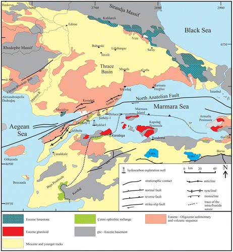
The main vestige of the older convergent tectonic régime in the Marmara Region and the surrounding area is the Thrace Basin (Figure ). This large basin developed as a forearc basin between the Eocene and Oligocene above the northward subducting Intra-Pontide Ocean. Its post-Oligocene history has been dominated by strike-slip tectonics that also led in its later stage to the opening of the Sea of Marmara over the Thrace Basin. Therefore, unraveling the tectono-stratigraphic evolution of the Thrace Basin may contribute to the understanding of the formation and the configuration of the Sea of Marmara Basin. This is the main purpose of this paper and therefore in the following paragraphs, we discuss first the geological evolution of the Thrace Basin and then try to relate this evolution to the formation of the Sea of Marmara. The tectonic setting, stratigraphy and structural geology of the basin are described here briefly, therefore interested reader is referred to Ataman and Gökçen (Citation1981), Doust and Arıkan (Citation1974), Görür and Okay (Citation1996), Huvaz, Nohut, and Sarıkaya (Citation2005), İslamoğlu et al. (Citation2008), Keskin (Citation1974), Okay, Özcan, Cavazza, Okay, and Less (Citation2010), Perinçek (Citation1991), Siyako and Huvaz (Citation2007), Turgut, Türkaslan, and Perinçek (Citation1991), and Sümengen and Terlemez (Citation1991). The stratigraphic nomenclature used in this paper is taken basically from Doust and Arıkan (Citation1974) and Görür and Okay (Citation1996).
Figure 1. Geological map of the Thrace Basin and its surrounding (modified from Okay et al., Citation2010).
2. Geological evolution of the Thrace Basin
2.1. Tectonic setting
The Thrace Basin typically lies between the Strandja Magmatic Arc in the north and the Intra-Pontide Suture in the south, indicating that it was in a forearc position during its formation (Figure ). The Strandja Magmatic Arc developed as a part of the much larger Rhodope-Pontide Magmatic Arc in the Strandja Massif during the late Cretaceous to early Oligocene time (Natal’in, Sunal, Satır, & Toraman, Citation2012; Okay, Tansel, & Tüysüz, Citation2001). It is represented mainly by granodiorites, andesites, tuffs, agglomerates and pyroclastic rocks of mainly Upper Cretaceous age (Aykol, Citation1979; Aykol & Tokel, Citation1991; Taner & Çağatay, Citation1983). Magmatic rocks of the Eocene to Oligocene age consist mainly of andesitic and dacitic tuffs. They are commonly found along the arcward flank and inside the Thrace Basin, indicating that the volcanism was coeval with the forearc sedimentation.
Figure 2. Tectonic setting of the Thrace Basin, showing the major paleotectonic units in the Marmara Region.
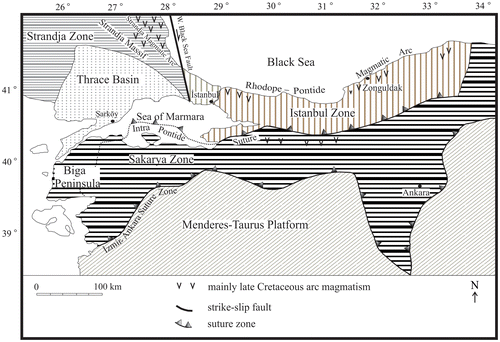
The Intra-Pontide Suture Zone forms the southern boundary of the Istanbul and the Strandja Zones in the north and separates them from the Sakarya Zone in the south (Şengör & Yılmaz, Citation1981) (Figure ). In the Marmara region, it is characterized mainly by an ophiolitic mélange (Çetmi ophiolitic mélange), consisting of sheared and fractured serpentinite, foliated blueschist facies metamorphic rocks and diabase dykes in peridotite (Görür & Okay, Citation1996; Okay et al., Citation2010; Siyako & Huvaz, Citation2007; Yaltırak, Citation1996; Yazman, Citation1997) (Figure ). The mélange have yielded late Cretaceous Rb-Sr and Ar-Ar phengite ages (Erol, Citation2003; Okay et al., Citation2010; Şentürk & Okay, Citation1984; Topuz, Okay, Altherr, Satır, & Schwarz, Citation2008). The main evidence for this suture comes from the east of the Sea of Marmara where it separates the Istanbul and the Sakarya Zones with entirely different basement and cover rocks along a zone of intensively sheared ophiolites, showing evidence of an original southerly vergence (Figure ) (Okay et al., Citation1996; Okay, Siyako, and Bürkan, Citation1991; Okay, Şengör, and Görür, Citation1994; Şengör, Citation1984; Şengör and Yılmaz, Citation1981; Yılmaz, Citation1990; Yılmaz, Citation1990). There is no consensus on the age of the Intra-Pontide Suture. Some geologists think that it closed during the late Cretaceous to Palaeocene (Cavazza, Federici, Okay, & Zattin, Citation2012; Görür, Şengör, Akkök, & Yılmaz, Citation1984; Şengör & Yılmaz, Citation1981; Tüysüz, Citation1999), whereas others believe that it was eliminated in the early Cretaceous (Akbayram, Okay, & Satır, Citation2013). However, as discussed below, the spatial, temporal and structural relationships between the Thrace Basin, Intra-Pontide Suture and the Rhodope-Pontide Magmatic Arc suggest that the complete elimination of the Intra-Pontide Ocean in the Thrace Region took place during or just before the Lutetian.
2.2. Stratigraphy
The Thrace Basin has an upward-shoaling sedimentary sequence of Lower Eocene to Recent age, resting unconformably on the ophiolitic mélange and metamorphic rocks of the Intra-Pontide Suture Zone and Strandja Massif, respectively (Görür & Okay, Citation1996; Okay et al., Citation2010; Siyako & Huvaz, Citation2007) (Figure ). In the center of the basin, the sedimentary infill is more than 9000-m-thick and starts with ca. 4000 m siliciclastic turbidites and associated pelagic carbonates of the Middle Eocene to Lower Oligocene age (Keşan Formation) (Ataman & Gökçen, Citation1981; Doust & Arıkan, Citation1974; Görür & Okay, Citation1996) (Figure ). The lower Eocene sediments seem to be absent in major part of the basin. They outcrop only in the southern margin to the south of the Ganos Fault as a small erosional remnant. Here, they consist of clastic and carbonate rocks (Dışbudak Series of Okay et al., Citation2010), representing an upward-deepening sedimentary sequence. Upward in the section in the basin center, the Keşan Formation contains pyroclastic material and ashfall tuffs of andesitic, dacitic and rhyolitic composition and passes into the Upper Oligocene marginal marine to continental and locally tuffaceous clastic and carbonate sediments (Muhacir and the overlying Danişmen Formations). These sediments are then followed unconformably by 1700-m-thick fluvio-lacustrine graben deposits of the Plio-Quaternary age (Ergene Formation) (Figure ).
Figure 3. Stratigraphy of the Thrace Basin.
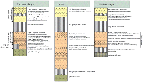
The basin margin sequence rarely exceeds the thickness of 2500 m and is represented mainly by reefal carbonates and shallow-to deep-water clastics. On the southern margin, the sequence commences, where it exists, with the Dışbudak Series (Figure ). Otherwise it starts with ca. 600-m-thick Middle to Upper Eocene reefal carbonates (DolucaTepe Formation) and the associated basal clastics (Ballık Dere Formation). The reef limestones than pass up into the Upper Eocene to Lower Oligocene turbiditic clastics (Mürefte and Tavri Formations), equivalents of the Keşan Formation in the basin center. However, these turbidites seem to contain in some localities abundant olistoliths derived from the Çetmi ophiolitic mélange and the reefal DolucaTepe Formation. Towards the top, the turbidites are followed by marginal marine to continental clastic deposits of the Upper Oligocene age. The succesion continues upward across an angular unconformity with the Middle to Upper Miocene continental to shallow marine rocks (Gazhanedere and Kirazlı Formations) (Turgut et al., Citation1991). Fluvio-lacustrine and brackish-water clastic and carbonate sediments of the Plio-Quaternary age sit on these rocks above an angular unconformity (Eriklice Group, the lateral equivalent of the Ergene Formation) (Figure ). The northern margin of the basin shows similar stratigraphic and facies characteristics to the southern margin (Saray Group), although deposition of the sediments here seems to have started a bit later in the Eocene with well-developed reef carbonates (Kırklareli Formation, equivalent of the Doluca Tepe Formation) (Figure ).
2.3. Structural geology
Geological structures of the Thrace Basin are dominated by folds, faults and unconformities. Because of the little-deformed but extensive Plio-Quaternary sedimentary cover and the Sea of Marmara, these structures can mostly be examined in the subsurface. Therefore, our knowledge about them comes mainly from seismic reflection studies and borehole data. In the following paragraphs, they are described on land and in the Northern Trough of the Sea of Marmara that seems to constitute the eastward continuation of this basin.
2.3.1. Folds
Folds mostly affect the sediments older than the Pliocene age. They are generally broad, short and discontinuous linear features with two distinct trends: NE–SW and NW–SE (Figure ). The NE–SW trending folds predominate over the others and occur in the southern and the central parts of the basin. The NW–SE trending folds seem to be common along the Strandja Massif in the north. The former structures trend obliquely, but at low angles, to this massif, whereas the latter extends parallel to it (Figure ).
Figure 4. Structural map of the Thrace Basin (compiled from Demirbağ, Rangin, Le Pichon, & Şengör, Citation2003; Doust & Arıkan, Citation1974; Görür & Okay, Citation1996; Perinçek, Citation1991; Şaroğlu, Emre, & Kuscu, Citation1992; Seeber et al., Citation2004; Sünnetçioğlu, Citation2008; Turgut, et al., Citation1991; Ustaömer et al., Citation2008; Yaltırak, Citation1995). KFZ = Kırklareli Fault Zone, LFZ = Lüleburgaz Fault Zone, BFZ = Babaeski Fault Zone, GFZ = Ganos Fault Zone, OF = Osmancık Fault, AR-1 = Arızbaba-1 well, DÇ = Deveçatağı well, ST-2 = Sütlüce-2 well, EM-1 = Emirali-1 well, KL-2 = Karacaoğlan-2 well, HMT-1 = Hamitabat- 1 well, HMT-6 = Hamitabat-6 well, KL-3 = Karacaoğlan-3 well, TD = Tekirdağ Depression, WMR = Western Marmara Ridge, MF = Marmara Fault, CD = Central Depression, CMR = Central Marmara Ridge, KD = Kumburgaz Depression, CND = Çınarcık Depression. The inset shows the shear evolution in a strike-slip zone and the structures generated (Tchalenko, Citation1970).
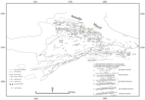
Folds are mostly symmetrical throughout the basin, but towards the margins asymmetrical and overturned folds are also observed. Along the Strandja Massif, they occur as en-echelon structures, passing along their length from asymmetrical anticlines into reverse-faulted or thrust anticlines with various displacements (Doust & Arıkan, Citation1974) (Figure ). Along the Ganos Fault in the south, folds are generally asymmetric, tight and are sometimes overturned to south around the Hisarlıdağ-Korudağ uplift, they are represented by an asymmetrical anticlinorium with a number of synform and antiform structures (Tüysüz, Barka, & Yiğitbaş, Citation1998).
The fold system in the Northern Trough of the Sea of Marmara is short, discontinuous and observed mostly in the eastern part of the Mid-Marmara Ridge, west of the Kumburgaz Depression (Figure ). They generally extend in NE–SW direction in accordance with the fold trend along the Ganos Fault. Between the Kumburgaz and Çınarcık Depressions there is a broad and westward vergent anticlinorium. Its Plio-Quaternary strata show peculiar undulatory structures with an NE–SW orientation. These structures were interpreted as shallow faults by Okay, Kaşlılar-Özcan, İmren, Boztepe-Güney, Demirbağ and Kuşçu (Citation2000), giant ripples in conturites by Imren et al. (Citation2001) and creep folds by Shillington et al. (Citation2012).
2.3.2. Faults
Two types of faults are observed in the basin: dip-slip and strike-slip faults (Figure ). Dip-slip faults occur along the northern and the southern margins, more or less parallel with the regional trends. In the northern margin, they are dominated by NW–SE-trending normal faults, whereas in the southern margin they are characterized mostly by NE–SW-trending reverse faults (Figure ). The dip-slip faults may be described under three groups. The first group includes deep-seated normal faults with an average vertical throw of about 100 m. They form a boundary fault zone between the Strandja Massif and the basin infill. They mostly affect the Lower to Middle Eocene sediments, although, owing to reactivation, they also cut younger sediments. These faults appear to have controlled sedimentation at least until the end of the Middle Eocene. Osmancık Fault seems to represent this group (Figure ) (Doust & Arıkan, Citation1974; Perinçek, Citation1991; Turgut, Siyako, & Dilki, Citation1983). The second group cuts the entire Tertiary sequence, except the Pliocene sediments. The latter covers them across an angular unconformity. These faults are generally south-dipping high-angle normal faults. The third group occurs in the basin in association with the folds and strike-slip faults. Fold-related dip-slip faults are found in the basin disrupting the anticlines or synclines. If the folds are symmetrical they are mostly normal faults, but if they are asymmetrical or overturned these faults appear to be reverse in nature. This group of faults mostly affect the sediments older than the Upper Pliocene. The dip-slip faults, which are associated with the strike-slip faults, occur either as a part of the strike-slip faults or form a component in their releasing or restraining bends; in the former they are normal faults, whereas in the latter they are reverse faults. This last group of dip-slip faults is common along the dextral strike-slip faults of the northern and the southern margins and mainly Miocene in age.
In the Thrace Basin, there are four right-lateral strike-slip fault zones: Kırklareli, Lüleburgaz, Babaeski and Ganos fault zones (Perinçek, Citation1991) (Figure ). The first three zones developed along the northern margin of the basin with an orientation parallel to the Strandja Massif. These fault zones display normal and reverse separations along most of their courses and therefore have a dip-slip fault appearance. This, of course, makes their differentiation from the dip-slip faults difficult, especially where they coincide (for instance, the Osmancık and the Kırklareli Fault Zones coincide in the area between the Deveçatağı and Emirali boreholes) (Figure ) (Perinçek, Citation1991). Furthermore, when the strike-slip faults reactivated the older dip-slip faults, recognition may even be impossible. These three strike-slip faults are buried by the Upper Pliocene sediments, suggesting that they had already stopped their activities by this time period. They probably formed during the Middle Miocene when the dextral North Anatolian Shear Zone (NASZ) started to develop in the region. The Ganos Fault stretches between the Sea of Marmara and the Aegean with a prominent geomorphological feature. It is also dominated by transpressive and transtensional structures along its course. The former includes thrusts and overturned synclines, whereas the latter is characterized mostly by the normal faults and negative flower structures (Figure ). This fault probably formed during the Pliocene, because the Miocene beds along this fault zone do not exhibit any features indicating that their deposition was coeval with its activity (Okay, Demirbağ, Kurt, Okay, & Kuscu, Citation1999; Yaltırak, Citation2002).
In the Northern Trough of the Sea of Marmara, dip-slip normal faults are found mostly in the easternmost part of the Central Marmara Ridge, SW of the Kumburgaz Depression where they strike commonly NW–SE in harmony with the normal faults along the Strandja Massif (Figure ). In the depressions, they are usually related with the strike-slip faults. Dip-slip reverse faults occur mostly in the Western Marmara Ridge and show, contrary to the normal faults, a NE–SW trend, similar to that of the Ganos Fault (Figure ).
In the Northern Trough, dextral strike-slip faults represent the northern branch of the North Anatolian Fault Zone (NAF) and form a single fault system, called Marmara Fault (Imren et al., Citation2001; Laigle et al., Citation2008; Sorlien et al., Citation2012). The Marmara Fault is connected with the Izmit Fault in the east and with the Ganos Fault in the west (Figure ). To the west of the trough, the Marmara Fault is situated along the southern margin of the Tekirdağ Depression with a steep north dip (Figure ). Some E–W trending strike-slip faults are also present in the central part of the depression (Bécel et al., Citation2010; Şengör et al., Citation2005). To the east, the Marmara Fault enters the Central Depression where it makes a 5 km wide negative flower structure (Figure ) (Armijo, Meyer, Navarro, King, & Barka, Citation2002). Then the fault continues eastwards, through the Kumburgaz Depression, as far as the Çınarcık Depression (Bécel et al., Citation2010; Laigle et al., Citation2008).
2.3.3. Unconformities (or disconformities)
The sedimentary sequence of the Thrace Basin displays five major breaks in sedimentation (Figure ). They represent such time periods as late Cretaceous to early Eocene, medial Eocene, early Miocene, early Pliocene and early Pleistocene. The oldest one is an angular unconformity at the base of the sequence and developed throughout the basin, probably marking the beginning of its formation. The medial Eocene break represents widespread erosion in the basin. Owing to this intensive erosion, it merges with the basal unconformity in most parts of the basin (Figure ). The early Miocene break seems also accompanied with intensive erosion. The tectonics behind it appears to have affected the whole basin and led to a large-scale uplifting. Despite the great uplift (Doust & Arıkan, Citation1974), tilting and folding of the infill were limited as indicated by the non-angular positions of the sediments above and below of this surface. The early Pliocene break is an angular unconformity, representing a prominent gap in sedimentation. During its development there was an overall emergence and erosion in the Thrace Basin. The erosion appears to be more intensive along the basin margins compared with the basin interiors (Perinçek, Citation1991). The Lower Pliocene unconformity cuts the older tectonic features in most parts of the basin, indicating that they were deactivated before its formation. The early Pleistocene is represented by a lacuna in the Marmara Region. Shallow-marine sediments of the Middle to Late Pleistocene (Marmara Formation) rest directly on the Pliocene or older sediments, forming elevated coastal terraces (Ertek, Yıldırım, Güneysu, & Yaltırak, Citation2000; Sakınç & Yaltırak, Citation1997; Yaltırak et al., Citation2002). This suggests that the early Pleistocene was also a time of uplift and erosion resulted in places probably from the activities of the NAF.
2.4. Tectono-stratigraphic evolution
Sedimentological, structural and stratigraphic features of the infill of the Thrace Basin indicate that this basin evolved under two different tectonic régimes, namely forearc and and strike-slip. The forearc tectonics controlled the Eocene to Oligocene evolution of the basin, whereas the strike-slip tectonics has affected its post-Oligocene development. From the stratigraphic and structural analyses presented above, the following summary of tectono-stratigraphic evolution of the Thrace basin is suggested.
2.4.1. Forearc evolution
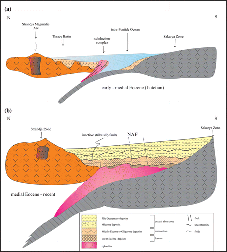
At the beginning of the Eocene time (Ypresian) in the Marmara Region, the Intra-Pontide Ocean was subducting beneath the Strandja Zone from the south and thus leading to the growth of the Çetmi ophiolitic subduction complex and Strandja Magmatic Arc (Figure (a)). The arc-trench gap was occupied by the Thrace Basin where the sediments of the Dışbudak Series were accumulating (Figure ). In the early Eocene, the İstanbul Zone was a part of the Moesian Platform and moving south along the dextral West Black Sea fault (Okay, Şengör, & Görür, Citation1994). It collided during or just before the medial Eocene (Lutetian) with the Sakarya Zone in the south. This collision obliterated the Intra-Pontide Ocean and caused deformation and erosion of the Dışbudak Series in most parts of the Thrace Basin (Figure (b)). However, the thick accretionary mélange that had developed till the Lutetian might have played a cushion role between the colliding continents and thus saved the basin from severe compression (Görür & Okay, Citation1996). Following the collision, an upward-shoaling mega sequence with turbidites overlain by shelf and nonmarine strata were deposited in the basin between the medial Eocene and the late Oligocene time (Figure ). Their deposition mostly took place under an intra-continental convergence in part with an extensional component. The presence of the calc-alkalic volcanic material in the Oligocene sediments indicates that the subducting oceanic slab continued its descent below the Strandja Magmatic Arc until this time (Görür & Okay, Citation1996). This indicates that the Thrace Basin became a remnant forearc after the closure of the Intra-Pontide Ocean. The magmatic arc thus formed highlands until the end of the Oligocene in the north and acted as a nearby source for the clastic sediments. The subduction complex in the south did not provide any material to the forearc until the late Eocene, because on the trench flank no sediments older than this age contain ophiolitic detritus. This probably indicates that the accretionary prism enlarged and formed a structural relief only during the late Eocene to early Oligocene time in the forearc basin. All the ophiolitic detritus observed in the olistostromal facies of the Mürefte and the Tavri Formations south of the Ganos Fault were probably shed from this structural high (Figure ). At the end of the Oligocene, the slab finally detached and fell that resulted in cessation of the arc magmatism with accompanied basin-wide uplift and erosion during the early Miocene (Figures and (a)). The early Miocene destructive events appear to mark the beginning of an important change in the tectonic régime of the area studied, because the post-early Miocene sedimentation and structural development in the whole Marmara Region bear no relation to the earlier forearc basin. This new tectonic régime was a dextral shear zone development in the large part of the Thrace Basin.
Figure 5. Sketches illustrating the tectono-stratigraphic evolution of the Thrace Basin. (a) In the early to medial Eocene the basin was a forearc basin accumulating the Dışbudak series or its equivalents. (b) During or just before the medial Eocene (Lutetian) the forearc basin closed and turned into a remnant forearc until the Oligocene. At the end of the Oligocene, it was deformed and underwent erosion throughout the early Miocene. From medial Miocene onward it has been integrated with the dextral North Anatolian Shear Zone.
2.4.2. Dextral shear zone evolution: formation of the sea of Marmara
Following the post-collisional deformation and erosion of the remnant forearc Thrace Basin in the early Miocene, all the previously forearc areas became a strike-slip shear zone. This zone constituted the widest part of the NASZ, extending between the East Anatolia and the Aegean as defined by Şengör et al. (Citation2005). Although these authors excluded most of the Thrace Basin from this shear zone, its coeval geological evolution and tectonic structures leave no doubt that it was a part of it at least since the medial Miocene. Şengör et al. (Citation2005) gave, as a whole, a Middle to Upper Miocene age to this deformation zone but did not explain in detail how it formed and evolved in the Thrace Basin. It formed here perhaps as a result of the escape tectonics of Turkey and developed along with the westerly motion of the Anatolian micro plate since the medial Miocene (Şengör, Görür, & Şaroğlu, Citation1985). In the following paragraphs, its evolution from medial Miocene up to now is discussed according to the structural stages of the Tchalenko (Citation1970).
Deformation of the shear zone in the Thrace Basin by dextral displacement resulted in the formation of a number of tectonic structures characterizing various stages of the shear evolution as suggested by Tchalenko (Citation1970) and Şengör (Citation1995). These stages included pre-peak, peak, post-peak and pre-residual structure stages (Tchalenko, Citation1970) (the inset in Figure ). The first two structure stages occurred probably during the medial to late Miocene (Görür & Okay, Citation1996), whereas the others took place during the Pliocene to Pleistocene.
The pre-peak structure stage marks in the Thrace Basin the beginning of the westerly motion of the Anatolian Plate in the medial Miocene. It was represented mainly by the NE–SW trending folds and the dip-slip faults of the NW–SE and NE–SW orientations, except the strike-slip fault-related ones (Figure ). Of course, the Eocene dip-slip faults should also not to be taken into account. Although the folds may have been attributed to the oblique closure of the Intra-Pontide Ocean (Görür & Okay, Citation1996), their involvement in the deformation of the Middle to Upper Miocene sediments may discard this possibility. However, some of them may be resurrected structures (Şengör et al., Citation1985).
As the shear progressed towards the late Miocene, the Thrace Basin evolved from the pre-peak structure stage into the peak structure stage. During this shear evolution, the structures which formed during the previous stage underwent a clock-wise rotation in certain extend along with the development of new ones (Tapırdamaz & Yaltırak, Citation1996). The peak structure stage was characterized by the NW–SE-trending strike-slip faults of the Thrace Basin (Kırklareli, Lüleburgaz and Babaeski Fault Zones) (Figure ). They were Riedel shears (R) and probably formed where the resistance to shear was maximum (Tchalenko, Citation1970). Conjugate Riedel shears (R’) seem not to have developed in this stage in the Thrace Basin.
Occurrence of the post-peak structure stage coincides in the Thrace Basin with the early Pliocene unconformity. It generated the NE–SW-striking right-lateral strike-slip faults as P-shears in the Thrace basin (i.e. the Ganos Fault) (Figure ). These faults lied roughly symmetrically to the Riedels with respect to the general direction of the movement. They appear to have formed in the areas underlain mostly by the accretionary complex of the Intra-Pontide Suture where the resistance to shears decreased (Tchalenko, Citation1970) (Figure ).
Pre-residual structure stage occurred in the Thrace Basin during the late Pliocene to Pleistocene. Following the early Pliocene deformational and erosional events, the shear zone lost its broadness and confined in a narrow belt between the Saros Bay and Gulf of İzmit (Figure ). This geomorphological development seems in a good agreement with the Riedel experiment of Tchalenko (Citation1970). According to his experiment, the width of the shear zone is decreased during the pre-residual structure stage. Following this spatial confinement, all the dextral shear-related activities concentrated at the Northern Marmara Trough and accelerated the development of a through-going strike-slip fault (i.e. the Marmara Fault). Of course, coincidence of the Intra-Pontide Suture with the trend of the northern trough may have also promoted this development. During the pre-residual structure stage, a number of P-shears developed during the late Pliocene to Pleistocene in the Northern Marmara Trough with a strike parallel to the tectonic trend (Figure ). The deep depressions of this trough seem to have formed during this structural stage as suggested by the seismic studies and the age of their infill. As they are cut by the P-shears, these bathymetric features perhaps developed in the early Pliocene when the topographic differentiation was taking place throughout the Thrace Basin. The structural configuration of the Northern Marmara Trough during the pre-residual structure stage may represent the initial state of the development of a master fault in this area. Şengör et al. (Citation2005) interpreted this development as the arrival of the North Anatolian Fault to the Sea of Marmara, no earlier than 200 ka ago.
3. Summary and conclusions
The Sea of Marmara formed in a region where successive forearc and strike-slip tectonic régimes had created a variety of structures with complex overprinting relationships. The forearc tectonic structures constituted its stratigraphic basement, whereas the subsequent strike-slip structures functioned coevally in part with its development. There is no doubt that all of these structures controlled to different extents its structural geology and geomorphology. Therefore, without detailed knowledge of these structures, it would not be possible to understand fully the dynamic régimes responsible for the formation and shaping of the Sea of Marmara.
The Thrace Basin evolved until the Lutetian as a forearc basin above the northward subducting Intra-Pontide Ocean. When the ocean closed during or just before the Lutetian, its content was largely deformed and eroded. Between the Lutetian and the Oligocene, it became a remnant forearc basin. At the end of the Oligocene, probably owing to the falling off the subducting slab, arc magmatism stopped and a major, basin-wide uplift and erosion took place during the early Miocene. In the medial to late Miocene, the basin was superimposed by a more extensive and much shallower dextral shear zone. This zone constitutes the westernmost part of the NASZ developed in relation to the escape tectonics of Turkey. Its evolution began in the medial Miocene and still continues with various tectonic structures, representing the pre-peak, peak, post-peak and pre-residual stages defined on the basis of the stress-displacement behavior and structures in the Riedel Experiment (Şengör et al., Citation2005; Tchalenko, Citation1970). The Sea of Marmara probably resulted from the development of the North Anatolian Shear Zone during the Late Pliocene to Pleistocene along a variety of Riedel, anti-Riedel and P-shears of the post-peak and pre-residual structure stages.
Acknowledgments
We thank A.M.C. Şengör for discussing with us the tectonics of the North Anatolian Shear Zone. Caner Imren, Doğan Perinçek, Muzaffer Siyako, Atilla Sefünç and M. Akif Sünnetçioğlu kindly supplied some open and published seismic data and gave permission to include them in this paper. Görür is grateful for the support of the Academy of Science. This paper is an outcome of the Marmara Supersite Project (MARsite).
References
- Akbayram, K., Okay, A. I., & Satır, M. (2013). Early Cretaceous closure of the Intra-Pontide Ocean in western Pontides (Northwestern Turkey). Journal of Geodynamics, 65, 38–55.
- Armijo, R., Meyer, B., Navarro, S., King, G., & Barka, A. (2002). Asymmetric slip partitioning in the Sea of Marmara pull-apart. A clue to propagation processes of the North Anatolian Fault. Terra Nova, 14, 80–86.
- Ataman, G., & Gökçen, S. L. (1981). Sedimentological characteristics of the Palaeogene flysches of Anatolia and Thrace and the relationships between their clay minerals (in Turkish). Hacettepe Universitesi Yerbilimleri Enstitüsü Bülteni, 7, 1–8.
- Aykol, A. (1979). Kırklareli-Demirköy Sokulumunun Petrolojisi ve Jeokimyası [Petrography and geochemistry of the Istranca-Demirköy pluton] (Unpublished assoc. dissertation) 204 p. İTU Mining Faculty, Turkey.
- Aykol, A., & Tokel, S. (1991). The geochemistry and tectonic setting of the Demirköy-Istranca granitoid chain, NW Turkey. Mineralogical Magazine, 55, 249–256.
- Bécel, A., Laigle, M., de Voogd, B., Hirn, A., Taymaz, T., Yolsal-Cevikbilen, S., & Shimamura, H. (2010). North Marmara Trough architecture of basin infill, basement and faults, from PSDM reflection and OBS refraction seismics. Tectonophysics, 490, 1–14.
- Cavazza, W., Federici, I., Okay, A. I., & Zattin, M. (2012). Pre-Cenozoic amalgamation of the Istanbul and Sakarya terranes (NW Turkey)-evidence from low-temperature thermochronology. Geological Magazine, 149, 133–140.
- Demirbağ, E., Rangin, C., Le Pichon, X., & Şengör, A. M. C. (2003). Investigation of the tectonics of the Main Marmara Fault by means of deep-towed seismic data. Tectonophysics, 361, 1–19.
- Doust, H., & Arıkan, Y. (1974). The geology of the Thrace Basin. In H. Okay & E. Dileköz (Eds.), Proceedings of the 2nd Petroleum Congres of Turkey (pp. 119–136). Ankara.
- Erol, K. (2003). Metamorphic Evolution of Yeniköy Melange (SW Thrace). Geological Bulletin of Turkey, 46, 53–61.
- Ertek, T. A., Yıldırım, C., Güneysu, A. C., & Yaltırak, C. (2000). Marmara Denizi Kıyı Taraçaları Korelasyonu [The marine terraces correlation on the sea of Marmara Coasts (Turkey)]. 1.Ulusal Deniz Bilimleri Konferansı, Bildiri özetleri kitapçığı, ODTÜ, Ankara, 108–109.
- Görür, N., & Okay, A. (1996). A fore arc origin for the Thrace Basin NW Turkey. Geology Rundsch, 85, 662–668.
- Görür, N., Şengör, A. M. C., Akkök, R., & Yılmaz, Y. (1984). Sedimentological evidence on the opening of the northern branch of the Neo-Tethys Ocean (in Turkish). Turkish Geological Society Bulletin, 26, 11–20.
- Huvaz, O., Nohut, O. M., & Sarıkaya, H. (2005). Principles of using well logs and geophysical data in quantitative basin modelling. Turkish Association of Petroleum Geologists Bulletin, 17(1), 1–18.
- Imren, C., Le Pichon, X., Rangin, C., Demirbağ, E., Ecevitoglu, B., & Görür, N. (2001). The North Anatolian Fault within the Sea of Marmara: A new interpretation based on multi-channel seismic and multi-beam bathymetry data. EPSL, 186, 143–158.
- İslamoğlu, Y., Harzhauser, M., Gross, M., Jiménez-Moreno, G., Coric, S., Kroh, A., … Van Der Made, J. (2008). From Tethys to Eastern Paratethys: Oligocene depositional environments, paleoecology and paleobiogeography of the Thrace Basin (NW Turkey). International Journal of Earth Sciences (Geology Rundsch), 99, 183–200.
- Keskin, C. (1974). Kuzey Ergene havzasının stratigrafisi [Stratigraphy of the northern Ergene Basin] In H. Okay & E. Dileköz (Eds.), Proceedings of the 2nd Petroleum Congress of Turkey (pp. 137–163). Ankara.
- Laigle, M., Bécel, A., de Voogd, B., Hirn, A., Taymaz, T., Ozalaybey, S., … Yolsal, S. (2008). A first deep seismic survey of the Sea of Marmara: Deep basins and whole crust architecture and evolution. Earth and Planetary Science letters, 270, 168–179.
- Natal’in, B. A., Sunal, G., Satır, M., & Toraman, E. (2012). Tectonics of the Strandja Massif, NW Turkey: History of a long-lived arc at the northern margin of Palaeo-Tethys. Turkish Journal of Earth Sciences, 21, 755–798.
- Okay, A., Demirbağ, E., Kurt, H., Okay, N., & Kuscu, I. (1999). An active, deep marine strike-slip basin along the North Anatolian fault in Turkey. Tectonics, 18, 129–147.
- Okay, A. I., Kaşlılar-Özcan, A., İmren, C., Boztepe-Güney, A., Demirbağ, E., & Kuşçu, İ. (2000). Active faults and evolving strike slip basins in the Marmara Sea, northwest Turkey: A multi-channel seismic reflection study. Tectonophysics, 321, 189–218.
- Okay, A. I., Özcan, E., Cavazza, W., Okay, N., & Less, Gy. (2010). Basement types, Lower Eocene Series, Upper Eocene Olistostromes and the initiation of the Southern Thrace Basin, NW Turkey. Turkish Journal of Earth Sciences, 19, 1–25.
- Okay, A. I., Satır, M., Maluski, H., Siyako, M., Monie, P., Metzger, R., & Akyüz, S. (1996). Paleo- and Neo-Tethyan events in northwest Turkey: Geological and geochronological constraints. In A. Yin, & M. Harrison (Eds.), Tectonics of Asia (pp. 420–441). Cambridge: Cambridge University Press.
- Okay, A. I., Şengör, A. M. C., & Görür, N. (1994). Kinematic history of the opening of the Black Sea and its effect on the surrounding regions. Geology, 22, 267–270.
- Okay, A. I., Siyako, M., & Bürkan, K. A. (1991). Geology and tectonic evolution of the Biga Peninsula. In J. F. Dewey (Ed.), Special Issue on Tectonics: Bulletin of the Technical University of Istanbul (pp.191–225), 44, İstanbul.
- Okay, A. I., Tansel, I., & Tüysüz, O. (2001). Obduction, subduction and collision as reflected in the Upper Cretaceous-Lower Eocene sedimentary record of western Turkey. Geological Magazine, 138, 117–142.
- Perinçek, D. (1991). Possible strand of the North Anatolian Fault in the Thrace Basin, Turkey – An interpretation. AAPG Bulletin, 75, 241–257.
- Sakınç, M., & Yaltırak, C. (1997). Güney Trakya sahillerinin denizel Pleyistosen çökelleri ve paleocoğrafyası. Bulletin of the Mineral Research and Exploration, 119, 43–62.
- Seeber, L., Emre, O., Cormiera, M. H., Sorlien, C. C., McHugh, C. M. G., Poloniad, A., … Çagatay, N. (2004). Uplift and subsidence from oblique slip: The Ganos–Marmara bend of the North Anatolian Transform, Western Turkey. Tectonophysics, 391, 239–258.
- Şengör, A. M. C. (1984). The Cimmeride orogenic system and the tectonics of Euraisa. Geological Society of America Special Paper, 195, xi+82.
- Şengör, A. M. C. (1995). Sedimentation and tectonics of fossil rifts. In C. J. Busby & R. V. Ingersoll (Eds.), Tectonics of Sedimentary Basins (pp. 53–117). Oxford: Blackwell Science.
- Şengör, A. M. C., Görür, N., & Şaroğlu, F. (1985). Strike-slip faulting and related basin formation in zones of tectonic escape: Turkey as a case study. In K. T. Biddle & N. Christie-Blick (Eds.), Strike-slip deformation, basin formation and sedimentation (pp. 227–264). Society of Economic Paleontologists and Mineralogist, Special Publication 37. Tulsa.
- Şentürk, K., & Okay, A. I. (1984). Saros Körfezi doğusunda yüksek basınç metamorfizması [Blueschists discovered east of Saros Bay in Thrace]. MTA Dergisi, Ankara, 97/98, 152–155.
- Şengör, A. M. C., Tüysüz, O., İmren, C., Sakınç, M., Eyidoğan, H., Görür, … Rangin, C. (2005). The North Anatolian Fault: A New Look. Annual Review of Earth and Planetary Sciences, 33, 37–112.
- Şengör, A. M. C., & Yılmaz, Y. (1981). Tethyan evolution ol Turkey: A plate tectonic approach. Tectonophysics, 75, 181–241.
- Shillington, D. J., Seeber, L., Sorlien, C. C., Steckler, M. C., Kurt, H., Dondurur, D., … Diebold, J. B (2012). Evidence for widespread creep on the flanks of the Sea of Marmara transform basin from marine geophysical data. Geology, 40, 439–442.
- Siyako, M., & Huvaz, O. (2007). Eocene Stratigraphic Evolution of the Thrace Basin, Turkey. Sedimentary Geology, 198, 75–91.
- Sorlien, C. C., Akhun, S. D., Seeber, L., Steckler, M., Shillington, D., Kurt, H., … Diebold, J. B. (2012). Uniform basin growth over the last 500 ka, North Anatolian Fault, Marmara Sea, Turkey. Tectonophysics, 518, 1–16.
- Sümengen, M., & Terlemez, I. (1991). Stratigraphy of the Eocene sediments from the southwestern Thrace (in Turkish). MTA Dergisi, 113, 17–30.
- Sünnetçioğlu, M. A. (2008). A sequence stratigraphic approach to the depositional history analysis of the Upper Eocene sedimentary succession, Northwest of Thrace Basin, Turkey (PhD thesis) (262 p.). The Graduate School of Natural and Applied Sciences of Middle East Technical University, Ankara.
- Şaroğlu, F., Emre, O., & Kuscu, I. (1992). Türkiye Diri Fay Haritası [Active Fault Map of Turkey], scale 1:2,000,000, one sheet. Maden Tetkik Arama Genel Müdürlüğü, Ankara.
- Taner, M., & Çağatay, A. (1983). Istranca masifindeki maden yataklarının jeolojisi ve mineralojisi [Geology and mineralogy of the ore deposits in the Strandja Massif]. TJK Bülteni, 26, 31–40, Ankara.
- Tapırdamaz, C., & Yaltırak, C. (1996). Trakya’da Senozoyik volkaniklerinin paleomanyetik özellikleri ve bölgenin tektonik evrimi [Paleomagnetic characteristics of the Cenozoic volcanics and tectonic evolution of thrace]. MTA Dergisi, 119, 27–42.
- Tchalenko, J. S. (1970). Similarities between shear zones of different magnitudes. Geological Society of America Bulletin, 81, 1625–1640.
- Topuz, G., Okay, A. I., Altherr, R., Satır, M., & Schwarz, W. H. (2008). Late Cretaceous blueschist facies metamorphism in southern Thrace (Turkey) and its geodynamic implications. Journal of Metamorphic Geology, 26, 895–913.
- Turgut, S., Siyako, M., & Dilki, A. (1983). Trakya havzasının jeolojisi ve hidrokarbon olnakları [The geology and the petroleum prospects of the Thrace basin]. Türkiye Jeoloji Kongresi Bülteni [Proceedings of the Geology Congress Turkey], 4, 35–46.
- Turgut, S., Türkaslan, M., & Perinçek, D. (1991). Evolution of the Thrace sedimentary basin and its hydrocarbon prospectivity. In A. M. Spencer (Ed.), Generation, accumulation, and production of Europe’s hydrocarbons (pp. 415–437). 135 Special Publication of the European Association of Petroleum Geoscientists 1. Oxford/New York: Oxford University Press.
- Tüysüz, O. (1999). Geology of the Cretaceous sedimentary basins of the Western Pontides. Geological Journal, 34, 75–93.
- Tüysüz, O., Barka, A. A., & Yiğitbaş, E. (1998). Geology of the Saros Graben: Its implications on the evolution of the North Anatolian Fault in the Ganos-Saros region, NW Turkey. Tectonophysics, 293, 105–126.
- Ustaömer, T., Gökaşan, E., Tur, H., Görüm, T., Batuk, F. G., Kalafat, D., … Birkan, H. (2008). Faulting, mass-wasting and deposition in an active dextral shear zone, the Gulf of Saros and the NE Aegean Sea, NW Turkey. Geo-Marine Letters, 28, 171–193.
- Yaltırak, C. (1995). Gaziköy – Mürefte (Tekirdağ) arasının sedimanter ve Tektonik özellikleri [Sedimentary and the tectonic characteristics of between Gaziköy-Mürefte (Tekirdağ)]. TPJD Bülteni, 6, 93–112.
- Yaltırak, C. (1996). Tectonic history of the Ganos fault system. Turkish Association of Petroleum Geologists Bulletin, 8, 137–156.
- Yaltırak, C. (2002). Tectonic evolution of the Marmara Sea and its surroundings. Marine Geology, 190, 493–529.
- Yaltırak, C., Sakınç, M., Aksu, A. E., Hiscott, R. N., Galleb, B., & Ülgen, U. B. (2002). Late Pleistocene uplift history along the southwestern Marmara Sea determined from raised coastal deposits and global sea-level variations. Marine Geology, 190, 283–305.
- Yazman, M. (1997). Kuzey Ege’nin jeolojisi ve petrol olanakları [Geology and prospectivity of the North Aegean offshore, Western Turkey]. İTÜ Colloquium, 45–52.
- Yılmaz, Y. (1990). Allochthonous terranes in the Tethyan Middle East: Anatolia and surrounding regions. Philosophical Transactions of the Royal Society A: Mathematical, physical and engineering sciences, 331, 611–642.