
Abstract
On the basis of gravity data, derived anomaly traces were presented for the interpretation of some shallow structural features of Biga and Gelibolu peninsulas. Since building general understanding of subtle details about subsurface geology is of great importance considering that the study area is tectonically important, some advanced data processing techniques were implemented to gravity anomalies in a detailed manner. The procedures were performed using a MATLAB-based software package (Gravity and Magnetic Interpretation – GMINTERP). First, a finite element method was utilised to produce the residual data-set which is expected to reflect short wavelength anomalies arising from shallower geological structures, and thereafter some derivative-based algorithms were executed to analyse the residual data. The general anomaly patterns obtained from the applications clearly corresponded to the well-known surface geology map of the study area. Derivative-based anomaly maps put forward some findings about the existence of an old caldera structure in the western part of the Biga Peninsula. Additionally, abrupt lateral changes in anomaly amplitudes indicated the presence of some major structural discontinuities. Thus, findings yielded to make significant geological interpretations that might be important for further investigations. This study also showed that GMINTERP software package proved useful in assisting geological interpretation using geophysical potential field data-sets.
1. Introduction
Herein, we aim to contribute to the understanding of the nature of some shallow structural features of the Biga and Gelibolu peninsulas, and their surroundings by analysing Bouguer gravity anomalies. It is well known that the complex geological structure of the western Anatolia has attracted intense attention so far, and numerous geophysical investigations have been performed using potential field data-sets. Some of these studies have involved entire or some parts of the area that is presented here, and they have mainly focused on mapping the geologic contacts, faults and the seismogenic zones, and determining the crustal features and crustal thickness of the region (e.g. Albora, Uçan & Aydoğan, Citation2007; Ateş, Bilim, Büyüksaraç, & Bektaş, Citation2008; Ateş, Kayıran, & Sincer, Citation2003; Aydoğan, Citation2007; Aydoğan, Elmas, Albora, & Uçan, Citation2005; Hisarlı & Orbay, Citation2000; Oruç & Keskinsezer, Citation2008a; Ulugergerli, Seyitoğlu, Başokur, Kaya, & Dikmen, Citation2007). However, except for some recently reported works (Ekinci & Yiğitbaş, Citation2012a, 2012b) which have studied the airborne magnetic anomalies of the igneous rocks that occupy a considerable amount of area in the Biga Peninsula and its surrounding, no special geophysical investigation has been yet performed in the entirety of the Biga and Gelibolu peninsulas and their surroundings which focuses on the shallow geological structure of the region. Hence, to fill that gap, we attempted to investigate the shallow subsurface geology and structural features in some detailed framework by interpreting and correlating the gravity anomalies with the geology of the region which is better known now by the recent regional geological projects of Duru, Dönmez, Ilgar, Pehlivan, and Akçay (Citation2012) and Yiğitbaş, Şengün, and Tunç (Citation2014).
Gravity anomaly interpretation procedures consist of many special techniques depending on the quality of the data-set and the goals of the analysis (Hinze, von Frese, & Saad, Citation2013). These data processing techniques may facilitate the interpretation of the potential field anomaly maps, and may also aid geological mapping (Blakely, Citation1995). Gravity anomaly maps are generally analysed by employing some linear transformations, directional derivative-based techniques and inverse modelling techniques. Among them, linear transformations may assist geological interpretation, and provide some insights about the nature of the causative geological sources (Blakely, Citation1995). Analytic continuations (upward and downward) are the most commonly used linear transformations in gravity data processing (e.g. Ateş et al., Citation2012; Aydemir, Ateş, Bilim, Büyüksaraç, & Bektaş, Citation2014; Büyüksaraç, Citation2007; Gibert & Galdeano, Citation1985; Gunn, Citation1975). Directional derivative-based techniques commonly use vertical or horizontal gradients (derivatives) of degree first or second, analytic signal (AS) amplitudes or their various combinations in order to improve the edges, and also to outline the possible boundaries of the gravity and pseudogravity sources (e.g. Balkaya, Göktürkler, Erhan, & Levent, Ekinci, Citation2012; Blakely & Simpson, Citation1986; Debeglia & Corpel, Citation1997; Oruç, Citation2011, 2014; Roest, Verhoef, & Pilkington, Citation1992). Inversion techniques are frequently used to estimate the model parameters whose responses are similar to the measured data, but the well-known under-determined and non-uniqueness nature of the potential field data makes the processing and interpretation difficult. Thus, the inverse modelling problem intensely requires prior information and some constraints in order to recover interpretable and realistic model solutions (e.g. Camacho, Montesinos, & Vieira, Citation2000; Ekinci, Citation2008a, Citation2008b; Feng, Meng, Chen, & Zhang, Citation2014; Last & Kubik, Citation1983; Li & Oldenburg, Citation1998; Roy, Sen, McIntosh, Stoffa, & Nakamura, Citation2005; Zhdanov, Citation2009; Zhdanov, Ellis, & Mukherjee, Citation2004; Sun, Liu, Shou & Zhang (2012)).
The success of the interpretation of potential field data-sets undoubtedly depends on the selection of the data processing techniques that are proper to the nature of the problem. Consequently, potential field data-sets generally need many processing techniques in order to produce meaningful results which are in accordance with the nature of the geology of the area of interest (Ekinci & Yiğitbaş, Citation2012b, 2012c). Numerous commercial software packages (e.g. Geosoft Oasis Montaj, Geosystem WinGlink, MagPick and IGMAS) are commonly used for analysing the potential field data-sets by employing some of the techniques specified above. Additionally, many freeware and open-source codes which have focused on particular issues and problems can be found in the literature (e.g. Arısoy & Dikmen, Citation2011; Cooper, Citation2009; Cooper & Cowan, Citation2005, 2006, 2008; Durrheim & Cooper, Citation1998). However, freeware and commercial software packages may not meet the requirements in some cases, since they do not include all the required data processing techniques in their own libraries. Therefore, an efficient toolkit named as Gravity and Magnetic Interpretation (GMINTERP) that performs numerous analysing techniques was developed and used for processing the gravity data-set of the Biga and Gelibolu peninsulas, and their surroundings. A brief overview of the developed toolkit was previously given by Ekinci and Yiğitbaş Citation(2012b). Before the real gravity data analyses, a large number of synthetic simulations were implemented with success, indicating the reliability of the GMINTERP software. The MATLAB-based interactive toolkit which consist of a set of linked functions in conjunction with a graphical user interface (Ekinci, Citation2010a; Ekinci & Yiğitbaş, Citation2012b, 2012c) produced some noteworthy anomaly maps from the gravity data-set of the study area and we discussed the geological implications of those derived gravity signatures.
2. Study area
Turkey lies within a highly active tectonic belt which is characterised by significant neotectonic structures (Figure ), and consists of several continental fragments which were joined together into a single landmass finally in the late Tertiary (Okay, Citation2008). These continental terranes were separated by oceans whose relics are widely distributed throughout the Anatolia during most of the Phanerozoic (Okay, Citation2008). Strandja, İstanbul and Sakarya are the well-known terranes in northern Turkey (Figure ), and they are called as the Pontides (Okay, Citation2008). Armutlu–Ovacık Zone (Figure ) is a tectonic mix of İstanbul and Sakarya zones (Elmas & Yiğitbaş, Citation2001, Citation2005; Yiğitbaş, Elmas, & Yılmaz, Citation1999). The Pontides, the Anatolide–Tauride block and the northern part of Arabian Plate are pronounced as the main tectonic units of Turkey (Ketin, Citation1966), and they are separated by sutures that represent the boundaries of former lithospheric plates i.e. tectonic lines (Okay & Tuysuz, Citation1999). The İzmir–Ankara–Erzincan suture (Figure ) that was formed by the closure of the northern branch of the Neo-Tethys Ocean separates the Pontides and the Anatolide–Tauride block from each other (Şengör & Yılmaz, Citation1981). The northern part of the Arabian Plate was separated from the Anatolide–Tauride block by the southern branch of the Neo-Tethys Ocean (Şengör & Yılmaz, Citation1981). The continuing convergence of the African, Arabian and Eurasian plates since the Middle Miocene, and the westward migration of the Anatolian Plate predominantly effects the neotectonic regime of Turkey (Figure ) (Dewey & Şengör, Citation1979; Jackson & McKenzie, Citation1984, Citation1988; Ketin, Citation1948; McKenzie, Citation1970, Citation1972; Şengör & Yılmaz, Citation1981).
Figure 1. Simplified neotectonic and relief maps of Turkey and the surrounding area (compiled with Yiğitbas, Elmas, Sefunç, and Özer, Citation2004) and CGIAR-CSI GeoPortal, Citation2012). Abbreviations: SBT, Southern Black Sea Thrust; NAFZ, North Anatolian Fault Zone; NEAFZ, Northeast Anatolian Fault Zone; WAEP, West Anatolia Extensional Province; EAFZ, East Anatolian Fault Zone; DSFZ, Dead Sea Fault Zone.
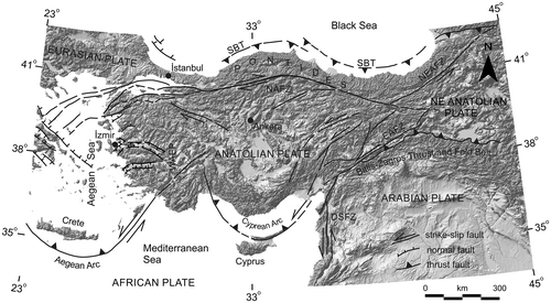
Figure 2. Simplified tectonic map of Turkey and surrounding regions, showing the main sutures and continental fragments (modified after Tunç et al., Citation2012) and the location of the study area (see rectangle)
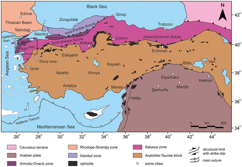
The study area, Biga and Gelibolu peninsulas and their surroundings, is located in north-west Turkey, and covers an area of about 21600 km2 (black rectangle in Figure ). It is bounded in the west by the Aegean Sea, in the north by Thracian Basin and Strandja Massif along the Intra-Pontide suture (Şengör & Yılmaz, Citation1981), and in the south by the Edremit Gulf. Tectonically, the study area is situated at the western end of the Sakarya Zone (Okay, Siyako, & Bürkan, Citation1991; Şengör & Yılmaz, Citation1981) which is separated by the İzmir–Ankara–Erzincan suture zone from the Anatolide–Tauride block (Şengör & Yılmaz, Citation1981).
2.1. Geology of the Gelibolu Peninsula
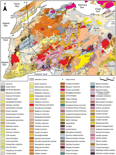
The upper Cretaceous Lört formation is the oldest unit in the Gelibolu Peninsula (Figure ). This formation composed mainly of pelagic limestone is unconformably overlain by the Ypresian–Lower Lutetian (Siyako, Bürkan, & Okay, Citation1989) regressive sequence (Karaağaç and Fıçıdere formations). These units are overlain by an upper Lutetian–upper Eocene transgressive sequence (Soğucak and Ceylan formations). The late Eocene–late Oligocene era is represented by strata displaying a regressive character (Mezardere and Armutburun formations) (Elmas & Meriç, Citation1998; Önal, Citation1986; Sümengen et al., Citation1987). The basement of the middle–upper Miocene/Quaternary sequence (Gazhanedere and younger formations in Figure ) in the Gelibolu Peninsula is formed by these entire assembly (Elmas & Meriç, Citation1998). In the Gelibolu Peninsula, the Anafartalar Fault formed as a positive flower structure and elevated the western parts of the Peninsula (Elmas & Meric, Citation1998; Yaltırak, Citation1995). The Ganos Fault bounds the Gelibolu Peninsula along its north-west area (Tüysüz, Barka, & Yiğitbaş, Citation1998). The Anafartalar and Ganos faults are the main structural features that have induced the evolution of the Çanakkale Strait (Yaltırak, Alpar, Sakınç, & Yüce, Citation2000). The Anafartalar thrust fault continues throughout the Gazhanedere formation (Albora et al., Citation2007; Yaltırak, Citation1995; Yaltırak, Alpar, & Yüce, Citation1998).
Figure 3. Geological map of the Gelibolu (modified after Dönmez, Akçay, Duru, Ilgar, and Pehlivan Citation2008) and Ilgar et al., Citation2008) and Biga peninsulas (modified after Duru et al., Citation2012).
2.2. Geology of the Biga Peninsula
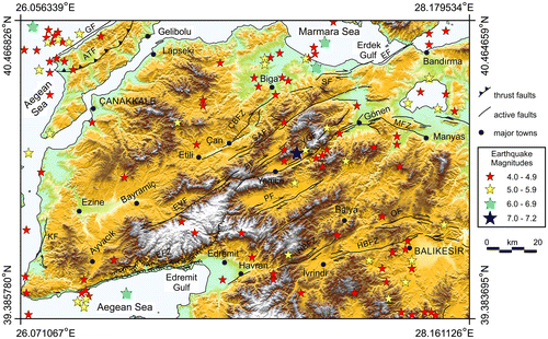
Biga Peninsula comprises different types of tectonic units that comprises the Sakarya Zone as an Alpine continental fragment in the south and Armutlu–Ovacık Zone which is a late Cretaceous–Eocene shear zone in the north (Elmas & Yiğitbaş, Citation2001; Şengün, Yigitbaş, & Tunç, Citation2011; Yiğitbaş, Şengün, & Tunç, Citation2009). Figure shows the geological map of the Biga Peninsula (Duru et al., Citation2012). The Biga Peninsula in north-west Turkey is characterised mostly by plutonic and associated volcanic rocks, ophiolites and amphibolite to granulite facies (Şengün, Davis, Tunç, & Yiğitbaş, Citation2012) metamorphic rocks. Gneiss, amphibolites and marbles form the basement of the Biga Peninsula and high- to medium-grade basement rocks occur in several parts (Okay & Satır, Citation2000a, Citation2000b) such as Kazdağ Massif, Çamlıca and Kemer metamorphics (Figure ). A geological cross-section from Gelibolu to Biga peninsulas (oriented in north–south and north-north-west–south-south-east as shown in Figure ) showing the major tectonic units is illustrated in Figure . In addition to its complex geology, the Peninsula is also situated in a neotectonically active region (Figure ) that has been affected by three main splay branches of North Anatolian Fault Zone (NAFZ) since the Middle Miocene (Aldanmaz, Pearce, Thirlwall, & Mitchell, Citation2000; Okay et al., Citation1991). The southern branch consists of the Bursa, Ulubat, Manyas, Yenice-Gönen, Evciler and Edremit faults (Kürçer, Yalçın, Gülen, & Kalafat, Citationin press), the middle branch continues across the Peninsula through the town of Ezine while the northern branch passes underneath the Sea of Marmara (Aldanmaz et al., Citation2000). In addition to these branches of NAFZ, the Peninsula has been deformed by the West Anatolian Extensional Province (WAEP) which consists of east–west trending horsts, sediment filled grabens and their basin-bounding active faults (Bozkurt, Citation2001; Gürer, Sangu, & Özburan, Citation2006). These deformations has caused dextral strike-slip faults with normal component (Barka, Citation1992; Barka & Kadinsky-Cade, Citation1988; Herece, Citation1990; Şaroğlu, Emre, & Kuşçu, Citation1992; Siyako et al., Citation1989), tectonic basins related to these faults and other deformation structures with obvious transcurrent component (Kürçer et al., Citation2008). Çan-Biga fault zone (ÇBFZ), Sarıköy Fault (SAF) and Yenice-Gönen Fault (YGF) are the active members of NAFZ in the Biga Peninsula (Figure ). Among them, the YGF is one of the most important active faults, and it has produced a very destructive earthquake Mw = 7.2 on 18 March 1953 (Caputo, Citation2005) with a focal depth estimation of 10–12 km (Herece, Citation1985). About 70-km-long dextral surface rupture occurred along the fault, and the fault can be followed through the alluvial area of Gönen and the Neogene deposits near Muratlar village, where the fault scarp is still evident (Kürçer et al., Citation2008). Active faults and the distributions of the epicentres of the earthquakes in the study area with magnitudes of M ≥ 4 are shown in Figure .
Figure 4. A simplified geological cross-section along A–B and B–C lines shown in Figure . Note that vertical axis of the cross-section was exaggerated and an approximate topography was used for the illustration.
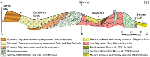
Figure 5. Topographic map of the study area showing the distributions of the epicentre of the earthquakes with magnitudes of M ≥ 4. The sizes of the stars are proportional to the earthquake magnitudes. The overlapped active faults in Biga Peninsula are modified after Duru et al. (Citation2012). The overlapped faults in Gelibolu Peninsula are modified after Yaltırak et al. (Citation2000). Black lines show coastline. Abbreviations: KF, Kestanbol Fault; EVF, Evciler Fault; ÇBFZ, Çan-Biga fault zone; SF, Sinekli Fault; SAF, Sarıköy Fault; YGF, Yenice-Gönen Fault; PF, Pazarköy Fault; EF, Edincik Fault; HBFZ, Havran–Balıkesir fault zone; OF, Ovacık Fault; BF, Bekten Fault; MFZ, Manyas fault zone; EFZ, Edremit fault zone; ATF, Anafartalar thrust fault; GF, Ganos Fault.
Biga Peninsula is generally dominated by the widespread occurrence of Tertiary plutonic and associated volcanic rocks of variable age and composition which are characteristic of middle–late Tertiary events (Beccaletto, Citation2003). Ezine–Kestanbol, Eybek, Ilıca–Şamlı, Karabiga and Evciler are the high-level granitoid intrusions which are related to magmatic activity (Demirel, Yıldırım, & Burçak, Citation2004). The exposed granitoid intrusions trend either north-east, following the major tectonic grain of the Peninsula, or east-north-east, cutting the major tectonic grain (Yigit, Citation2012). Active faults developed by neotectonic activities and also the young granitic and volcanic rocks have key importance on the geothermal sources in the Biga Peninsula. The Peninsula comprises more than 50 hot springs with temperatures ranging from 30 to 100 °C (Demirel et al., Citation2004), and therefore it is considered as a significant geothermal region in Turkey. Additionally, high heat flow values clearly dominate the extensional tectonic region in the southern part of the Peninsula (Pfister, Citation1995).
3. Gravity data and data processing
Gravity surveys of the entire Turkey were carried out by the General Directorate of Mineral Research and Exploration (MTA) of Turkey in the years between 1973 and 1988. MTA has accomplished 62,000 gravity observations in Turkey at station intervals of 2–5 km. The Geodesy Department of MTA has provided the locations and elevations of the gravity stations from 1:25,000 scale topographic maps (Ateş, Kearey, & Tufan, Citation1999). Gravity values were tied to MTA and General Command of Mapping base stations related to the Potsdam 981,260.00 mGal (1 Gal = 1 cm s−2) absolute gravity value accepted by the International Union of Geodesy and Geophysics in 1971 (Ateş et al., Citation1999). The gravity values are related to the International Gravity Standardization Network (Erden, Citation1979). All the corrections of the observed gravity data were carried out by the MTA. The corrections can be given as follows (Ateş et al., Citation1999): latitude corrections were carried out using the Gravity Formula of 1967; Bouguer corrections were performed assuming a density of 2.40 Mg m−3; topographic corrections were completed to a distance of 167 km assuming a terrain density of 2.40 Mg m−3; and lastly free-air and tidal corrections were performed. Complete Bouguer gravity anomaly map of entire Turkey can be seen in some publications (e.g. Ateş et al., Citation1999; MTA, Citation2006).
Herein, the gravity anomaly map of the study area was produced with a grid spacing of 2 km, which covers an area of 180 km × 120 km (Figure ). At the data processing stages, some potential field techniques (i.e. vertical derivative, downward continuation) were performed in wavenumber domain using the fast Fourier transform based on the method given by Blakely (Citation1995). As is well known, the nature of the fast Fourier transformation assumes that a grid is periodic, in effect repeating itself infinitely many times in all horizontal directions (Blakely, Citation1995). However, if the edges of the data grid do not meet smoothly with their repetitive neighbours the procedure may cause some edge effects (Blakely, Citation1995). Thus, to remove the possible discontinuities at the grid edges of the data-sets, the size of data grid was augmented to next higher power of 2 by adding artificially produced data bands to the east and north edges of data grid prior to the fast Fourier transform. The extra artificial data bands were removed from the data grid at the end of the operation.
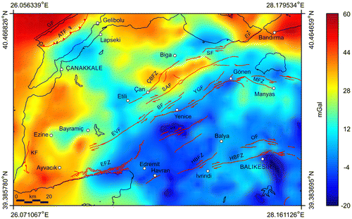
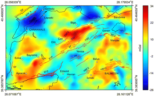
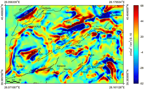
Figure 6. Complete Bouguer gravity anomaly map of the study area. The overlapped active faults in Biga Peninsula are modified after Duru et al. (Citation2012). The overlapped faults in Gelibolu Peninsula are modified after Yaltırak et al. (Citation2000). Abbreviations used for the faults are given in Figure .
3.1. Gravity anomaly separation
It is a well-known fact that the potential field anomaly maps present the effects of both shallow and deeper geological structures. These two components are named as regional trends and local (residual) anomalies, and can be expressed as follows (Pawlowski, Citation1994):(1)
where is the observed gravity field, s and d refer to the gravity response of shallow and deeper structures, respectively. Thus, one of the most important issues in potential field data interpretation is the removal of regional trends when dealing with relatively shallower local geological structures (Dobrin, Citation1976). Therefore, some mathematical methods are required to separate the map data into two components which are the regional nature and the local fluctuations (Davis, Citation2002). Since the study presented herein deals with the shallow geological structures of the Biga and Gelibolu peninsulas, regional/residual separation process was applied to gravity data-set in order to estimate the amplitude of the regional background.
Polynomial fitting procedure is the most commonly used technique for potential field anomaly separation. The procedure is based on the minimisation of the sum of the squares of the differences between the data and a polynomial of degree m evaluated at corresponding given observations (Hedgley, Citation1978). The function to be minimised is expressed as follows (Hedgley, Citation1978):(2)
where d is the degree of the model, xi and yi are the discrete points, aj is the coefficient to be determined, is the weighting factor and NP is the number of data points. Although there are some statistical approaches such as determining the correlation coefficients or goodness of fit, there have always been some difficulties of how to choose the best degree of the polynomial and what the functional form of the trend should be to obtain the optimum solution without specifying any prior information about nature of the data. When the higher order of the polynomial is preferred the better fit can be achieved and the curve may pass precisely through all the data points, but the regional anomaly may have no reasonable geological meaning (Lowrie, Citation2007). On the other hand, a finite element method (FEM) based on the use of element shape functions may yield optimum solutions without introducing a prior information (Mallick & Sharma, Citation1997, Citation1999). Additionally some other researchers have gained benefit from applying FEM to the potential field data-sets so far (e.g. Agarwal & Srivastava, Citation2010; Ekinci, Citation2010b; Ekinci & Yiğitbaş, Citation2012b; Kaftan, Salk, & Sari, Citation2005).
In the procedure of FEM, the amplitudes of the regional background are estimated by a weighted sum of discrete gravity values at eight stations coinciding with the eight nodes of a second-order isoparametric element superimposing the map space (Mallick & Sharma, Citation1999). Firstly, an eight node element is defined in x–y space (real-map space). xc, yc is the location of the centre and the sides parallel to the x- and y-axes are defined as 2a and 2b. The transformation of the real-map space to a corresponding reference space is performed by the following substitutions (Mallick & Sharma, Citation1999):(3)
A reference space is defined by the non-dimensional coordinates ξ and η, ranging between the values of −1 and 1 (Mallick & Sharma, Citation1999). The regional gravity at any point in the reference element is expressed by a series which is a weighted sum of the nodal gravity values (Mallick & Sharma, Citation1997):
(4)
where the weights, , are the shape functions of the element. The shape functions at the nodes 1 through 8 in reference space are computed by using following formulations (Cheung & Yeo, Citation1979):
(5)
Equation (Equation5(5) ) satisfies that the shape function
at the ith node and zero at the other nodes. Further,
(Mallick & Sharma, Citation1999). At the last step, the regional field computed on the reference ξ − η space is transformed to the real-map space by using following coordinate transformation (Mallick & Sharma, Citation1999):
(6)
where are the shape functions and xi and yi are the nodal coordinates in the real-map space (Mallick & Sharma, Citation1997, Citation1999).
Before the application of regional/residual separation procedure on real gravity data-set, some synthetic simulations were performed to test the success of FEM and the polynomial fitting technique. Considering a rectangular prism is one of the simple ways to approximate a volume of mass. The gravitational attraction of a single rectangular prism is easily computed by integration over the limits of the prism (Blakely, Citation1995), and the following derived equation can be used for the procedure (Plouff, Citation1976):(7)
where ρ is the density contrast and γ is the gravitational constant. The other terms are given by:(8)
The gravity response of three vertical-sided prisms was generated for the test simulations by running GMINTERP based on Equation (Equation7(7) ). We used a 0.25 km × 0.25 km grid interval for three-dimensional forward modelling. Model parameters of the causative prismatic bodies are given in Table . Figure (a) and (b) demonstrates the plan view of three-dimensional prismatic model bodies and the synthetically generated gravity anomaly map, respectively. Note that the gravity response of the model 3 was assumed to represent the regional effect. Figure (a)–(f) illustrates the computed regional and residual gravity anomaly maps from the application of FEM and polynomial fitting (second- and third-order) procedures. It is obviously seen that the gravity response of the deeper body (model 3) dramatically enhanced by the use of FEM (Figure (a)). However, the maximum gravity amplitudes could not be located over the causative deeper body by the use of polynomial fitting procedure (Figure (d) and (f)). It is worth mentioning here that these synthetic simulations indicated the superiority of the FEM over the polynomial fitting procedure. Thus, FEM was performed on the real gravity data-set shown in Figure , and regional (Figure ) and residual gravity anomalies (Figure ) were computed.
Table 1. Model parameters of three prismatic bodies used for the test simulations.
Figure 7. (a) General plan view of three prismatic theoretical model bodies used for the synthetic simulations. (b) Synthetically generated gravity data-set consisting of the anomalies caused by three-dimensional prismatic source bodies shown in (a), Contour interval: 0.4 mGal.
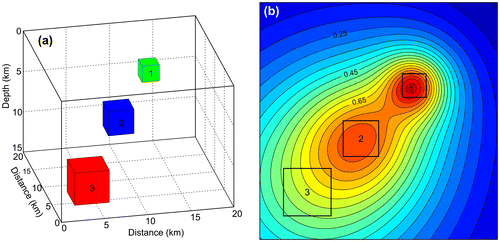
Figure 8. The results of the synthetic simulations obtained by regional/residual separation algorithms. Contour interval: 0.04 mGal. (a) Regional background computed by using FEM. (b) Residual anomaly map computed by using FEM. (c) Regional background computed by using second-order polynomial fitting procedure. (d) Residual anomaly map computed by using second-order polynomial fitting procedure. (e) Regional background computed by using third-order polynomial fitting procedure. (f) Residual anomaly map computed by using third-order polynomial fitting procedure.
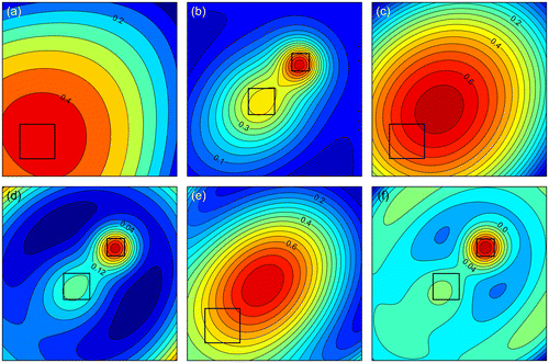
Figure 9. Regional gravity background of the study area computed by FEM based on the use of element shape functions. Contour interval: 4 mGal.
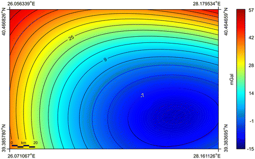
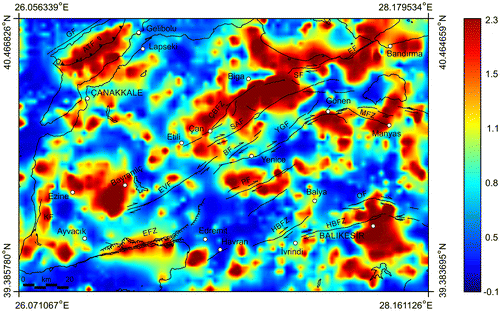
Figure 10. Residual gravity anomaly map of the study area. The overlapped active faults in Biga Peninsula are modified after Duru et al. (Citation2012). The overlapped faults in Gelibolu Peninsula are modified after Yaltırak et al. (Citation2000). Black lines show coastline. Abbreviations used for the faults are given in Figure .
3.2. Approximating the locations of the causative geological structures
In order to better understand the nature of the residual gravity anomalies and to trace the abrupt lateral changes in densities, firstly, we performed the technique of Blakely and Simpson (Citation1986) to the residual gravity data-set shown in Figure . Briefly, the technique is based on a two-step procedure when dealing with gravity data-sets. The shallow source bodies tend to produce gravity or pseudogravity anomalies with maximum horizontal gradients near their edges or boundaries (e.g. Balkaya et al., Citation2012; Blakely, Citation1995; Blakely & Simpson, Citation1986; Ekinci & Yiğitbaş, Citation2012b), therefore a total horizontal derivative (THD) anomaly map (Figure ) of the residual gravity data was produced by using the following expression (Blakely, Citation1995):(9)
Figure 11. THD anomaly map of the data shown in Figure . The overlapped active faults in Biga Peninsula are modified after Duru et al. (Citation2012). The overlapped faults in Gelibolu Peninsula are modified after Yaltırak et al. (Citation2000). Black lines show coastline. Abbreviations used for the faults are given in Figure .
where Δg is the gravity anomaly. Horizontal derivatives in Equation (Equation9(9) ) were estimated using simple finite-difference method and discrete values of
as follows (Blakely, Citation1995):
(10)
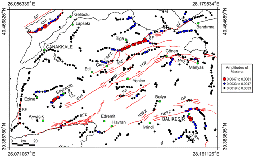
where i and j represent the discrete values of on the observation plane at uniform sample intervals Δx and Δy. At the second stage, we attempted to search for the maximum horizontal gradient amplitudes (Blakely, Citation1995; Blakely & Simpson, Citation1986) on the grid plane. Computed maxspot map, showing the maxima locations on the grid plane and their amplitudes is demonstrated in Figure .
Figure 12. Maxspot map showing the locations of the maximum horizontal gradient amplitudes. The overlapped active faults in Biga Peninsula are modified after Duru et al. (Citation2012). The overlapped faults in Gelibolu Peninsula are modified after Yaltırak et al. (Citation2000). Black lines show coastline. Abbreviations used for the faults are given in Figure .
Secondly, a profile curvature anomaly map (Figure ) was produced to improve the possible geological boundaries and lineaments and also to compare the results with those obtained by analysing the THD magnitudes (Figure ) of the residual gravity data. Recently, the effectiveness of the technique on gravity and pseudogravity data-sets for contact mapping has been reported by some researchers (Ekinci, Balkaya, Şeren, Kaya, & Lightfoot, Citation2014; Ekinci, Ertekin, & Yiğitbaş, Citation2013a, 2013b). Briefly, profile curvature operator measures the rate of change of the slope in the direction of the steepest gradient at each point of the data (Cooper, Citation2009), and produces a zero contour value at the source edges and either a local maxima or minima over the causative sources (Lee, Morris, Leblanc, & Harris, Citation2013). The definition of the profile curvature amplitude (P) for a gridded data-set is given by the following equation (Mitášová & Hofierka, Citation1993):(11)
Figure 13. Profile curvature anomaly map of the data shown in Figure . The overlapped active faults in Biga Peninsula are modified after Duru et al. (Citation2012). The overlapped faults in Gelibolu Peninsula are modified after Yaltırak et al. (Citation2000). Black lines show coastline. Abbreviations used for the faults are given in Figure .
where g is the gridded data, ∂x and ∂y are the horizontal derivatives while ∂x2 and ∂y2 are the second-order horizontal derivatives of the gridded data. Here, horizontal derivatives were computed using the terms in Equation (Equation10(10) ), while second-order horizontal derivatives were obtained using the following approximate definitions (Carnahan, Lither, & Wilkes, Citation1969):
(12)
Thirdly, 3D normalized full gradient (NFG) technique was applied to the residual gravity data-set to improve the subtle details of the geological sources, and to follow their downward extensions. NFG technique is based on the downward continuation of the potential field data and the NFG amplitude is computed by dividing the AS amplitude of the field by the average of AS amplitude using the following equation:(13)
where Δz is the downward continuation level and M is the number of data on the grid plane. Downward continuation of a potential field data can be obtained using the following substitution (Blakely, Citation1995):(14)
where g is the gravity field, F is the Fourier transform, F−1 is the inverse Fourier transform, Δz is the downward continuation level and e is the exponential function. is the radial wavenumber at grid intersections throughout the kx and ky plane, and is defined by following equation (Blakely, Citation1995):
(15)
The last component in 3D NFG, the AS amplitude, is a complex quantity and formed through a combination of the vertical and horizontal derivatives of the potential field data (Roest et al., Citation1992). The maxima locations in AS anomaly map are usually used to locate source bodies and also to improve the edges of them on the grid plane. The AS amplitude is obtained by using the equation as given below (Roest et al., Citation1992):(16)
where Δg is the measured gravity anomaly and ∂x, ∂y and ∂z are the directional derivatives. In order to produce the AS amplitudes, the horizontal derivatives (∂x and ∂y) were computed in space domain using the simple finite-difference method as expressed previously in Equation (Equation10(10) ) while vertical derivatives (∂z) were computed in wavenumber domain using the fast Fourier transform using the definition below (Blakely, Citation1995):
(17)
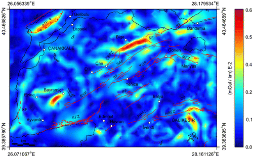
where g is the gravity field and the other terms were defined previously. The NFG technique was first used for exploring oil reservoirs (Berezkin, Citation1967; Berezkin & Buketov, Citation1965) and then used for various investigations (e.g. Aghajani, Moradzadeh, & Zeng, Citation2011; Ekinci & Yiğitbaş, Citation2012a, 2012b; Oruç & Keskinsezer, Citation2008b; Zeng et al., Citation2002). The normalisation procedure in NFG computation helps to minimise the strong field perturbation associated with downward continuation of the potential field data (Aghajani et al., Citation2011). Application of NFG technique typically enhances the anomalies by computing the anomaly to a level close to the source bodies and (Oruç & Keskinsezer, Citation2008b). Therefore, we produced the NFG map (Figure ) using the residual gravity data-set in order to monitor downward extent of the high amplitude gravity anomalies. The depth level of more than 1000 m was not computed due to the oscillations and undesired effects which distorted the real anomalies.
Figure 14. NFG depth slice map of the data shown in Figure . The overlapped active faults in Biga Peninsula are modified after Duru et al. (Citation2012). The overlapped faults in Gelibolu Peninsula are modified after Yaltırak et al. (Citation2000). Black lines show coastline. Abbreviations used for the faults are given in Figure .
4. Results and discussion
The complete Bouguer gravity anomaly map of the study area shown in Figure clearly displays both high and low amplitude anomalies. The north–south-trending high amplitude gravity anomaly zone which extends massively along the western coasts of the Biga and Gelibolu peninsulas is observed from the complete Bouguer gravity anomaly map. Some other high amplitude gravity anomalies located at the surrounding of Bandırma and at the east of Lapseki are also detected (Figure ). Additionally a high amplitude anomaly zone exists between the ÇBFZ and SAF. The southern and eastern edges of that anomaly zone are clearly bordered by SAF and a north-west–south-east-trending fault, respectively. The north-east–south-west-oriented lineament located in the Gelibolu Peninsula dramatically cut through the Peninsula and also indicates a sharp gravity contrast between the high and low amplitude anomalies (Figure ). Except for the low amplitude anomalies traced on the middle part of the Çanakkale Strait, north of Sinekli Fault (SF) and the vicinity of Etili district, complete Bouguer gravity anomaly characterisation seems to be mostly low (negative) which stretches from the Evciler Fault (EVF), SAF and SF to eastwards (Figure ). The lowest gravity anomaly pattern in the complete Bouguer gravity anomaly map is observed at the south of Havran–Balıkesir fault zone (HBFZ) which is near the province of Balıkesir. On the basis of those anomaly zones the general gravity amplitude variation observed from the complete Bouguer gravity anomaly map (Figure ) could be simply characterised by a decreasing trend towards the eastern parts of the study area i.e. inland. As is well known, gravity anomalies observed over the continental areas show generally negative gravity signatures due to the effect of thick crust, and oceanic regions where the crust is very thin are mostly characterised by positive gravity anomalies (e.g. Lowrie, Citation2007). In the same manner, the complete Bouguer gravity anomaly map of the study area (Figure ) demonstrably indicates that most of the land areas are represented by low amplitude (negative) gravity anomalies while high amplitude (positive) gravity anomalies mostly dominate the coastal and marine environment. Furthermore, as also explained previously by Ateş et al. Citation(1999), the gravity amplitude variation mentioned above is quite likely due to the effect of the isostatically thickened continental crust which gradationally increases in thickness towards the eastern regions.
Since the complete Bouguer gravity anomalies intensely represent the effects of the longer wavelength fields caused by the deeper and broader geological causative sources (Mallick, Vasanthi, & Sharma, Citation2011), the regional background (Figure ) was computed by using element shape functions of FEM. In order to amplify the responses of the relatively shallower causative geological units (short wavelength anomalies) and to attenuate the crustal effects (long wavelength anomalies), a residual gravity anomaly map (Figure ) was produced by removing the regional background (Figure ) from the complete Bouguer gravity field (Figure ) as mentioned in previous section. The computed regional background (Figure ) indicates a remarkable gravity discrepancy ranging between −15 and 57 mGals, and also exhibits an amplitude variation which can be characterised by an eastwardly decreasing trend in gravity values as expected. Figure displays that the computed residual gravity anomalies indicates a clear gravity contrast in the study area which could be regarded as sufficiently clear indicator to distinguish the effects of causative geological sources. High amplitude anomalies on the study area are located between Biga–Çan–Yenice–Gönen, Manyas–Balya–İvrindi–Balıkesir, Çanakkale-south of Ayvacık and the surroundings of Bandırma region (Figure ). On the contrary to the complete Bouguer gravity anomaly map shown in Figure , the western coasts of Biga Peninsula demonstrate a low amplitude gravity anomaly characterisation in the residual anomaly map (Figure ). When considering the geological map of the study area (Figure ), it is seen that alluvium and Bayramiç formation (conglomerate, sandstone, claystone, siltstone, etc.) are mostly prevalent at the Aegean coasts of the Biga Peninsula. Thus, it can be mentioned that those sedimentary units having relatively lower densities evidently contribute to the decreasing of the amplitudes of gravity anomalies. Additionally, the residual anomaly map (Figure ) points out that the aforementioned low amplitude gravity responses become wider in the east–west direction towards northern parts of the Aegean coasts of the Biga Peninsula. The behaviour of those anomaly signatures fits quite well with the surface geology map of the Peninsula (Figure ), because the geological map displays that Pliocene deposits (Bayramiç formation) and upper Miocene deposits (Çamrakdere member: sandstone, calcarenite, marl and siltstone) are wider in the east–west direction at the south of the entrance to the Çanakkale Strait in comparison to Ezine coasts. Similarly, the presence of alluvium and Bayramiç formation units give rise to the lowering of the gravity amplitudes at the coasts of Biga district. On the other hand, although the sedimentary cover (alluvium and Bayramiç formation) exists at the east of the Biga coasts (towards Bandırma district), gravity anomalies exhibit relatively higher amplitudes. One possible interpretation of this case is that the sedimentary covers overlying the Şapçı volcanics (andesite and pyroclastic rocks) and its correlative units in that region is relatively thinner in comparison to those of western parts.
The lowest amplitude residual gravity anomalies in the study area are observed in the eastern and southern parts of the Gelibolu Peninsula. A north-east–south-west-trending nearly longitudinally sharp gravity contrast is apparently recognised in the Peninsula (Figure ). When bearing in mind the surface geology map of the Gelibolu Peninsula (Figure ) and the residual gravity anomaly map of the study area (Figure ) together, it can be stated that the sharp gravity contrast with a north-east–south-west-trending lineament is associated with the response of the Anafartalar thrust fault which continues throughout the Gazhanedere formation (continental conglomerate, sandstone, mudstone, etc.). The anomaly signature of the Anafartalar thrust fault can be easily followed from the THD map (Figure ), maxspot map (Figure ). Profile curvature anomaly map (Figure ) also demonstrates the position of the thrust fault by producing zero contour values. Additionally, the anomaly trace of the westward fold of the Anafartalar thrust fault at the south of the Salt Lake is dramatically enhanced by computing the maximum horizontal gradient magnitudes (Figure ). NFG depth slice anomaly map (Figure ) displays a wider strong anomaly having high amplitudes from the surrounding of the Anafartalar thrust fault towards inland of the Biga Peninsula. Moreover, as clearly seen from Figure that the lowest gravity anomaly amplitudes dominate the vicinity of the Çanakkale Strait. Thus, it may be suggested that the thickest sedimentary deposits having low densities are located at the vicinity of the Çanakkale Strait in the study area.
A low amplitude gravity anomaly characterisation is clearly seen at the east and south-east of Balıkesir province (Figure ). Geological map of the study area (Figure ) exhibits that alluvium and Soma formation (conglomerate, sandstone, claystone, limestone, etc.) exist at the east and south-east of Balıkesir province. Thus, those sedimentary deposits having lower densities in comparison to bedrock cause a decrease in gravity values. On the other hand, Bornova flysch (ophiolitic rock and sandstone with limestone blocks, claystone and conglomerate), Yayla melange (serpentinite, spilitic basalt, gabbro, diabase, sandstone, claystone, etc.) and Hallaçlar volcanics (andesite, dasite, pyroclastic rocks, etc.) produce higher amplitude gravity anomalies at the surrounding of Balıkesir province due to their relatively higher densities (Figure ). THD anomaly map (Figure ) and, in particular, maxspot map (Figure ) clearly indicates the trace of the boundaries of the sedimentary deposits in the south of HBFZ around Balıkesir province. Maxspot map (Figure ) also indicates that the northern and western edges of the sedimentary deposits are characterised by larger maximum horizontal gradient amplitudes. This finding is most likely due to the abrupt lateral changes in densities between the sedimentary deposits and the high density Neo-Tethyan ophiolites and melange (Bornova flysch and Yayla melange) that form the northern edges of the İzmir–Ankara suture zone. Moreover, the spatial locations of the edges of sedimentary deposits on the grid plane correspond to zero contour value in profile curvature anomaly map (Figure ) which is in well agreement with the maximum horizontal gradient locations displayed in Figure . The existence of downward extend of this anomaly zone is also shown in NFG anomaly map (Figure ) and it must be noted that the anomaly zone appears to be wider in the image. Since the residual gravity anomaly map (Figure ) demonstrates that the anomaly of that sedimentary deposits are not characterised by very low values, it may be mentioned that the deposits are not quite thick. Thus, the wider anomaly zone seen in NFG image map (Figure ) might be caused by the high-density Neo-Tethyan ophiolites and melange which cover larger area in the subsurface than as exposed in the ground surface. Additionally, it may be stated that the sedimentary deposits overlie the Neo-Tethyan ophiolites and melange in that region.
One of the most remarkable high amplitude gravity anomaly zone is located between the districts of Biga–Çan–Yenice–Gönen (Figure ). The boundaries of that high amplitude gravity anomaly zone can be clearly observed from the maxspot map (Figure ). Zero contour values of profile curvature anomaly map (Figure ) are also compatible with the locations of maximum horizontal gradients. The northern boundary of that zone located nearly on the eastern parts of ÇBFZ produces the largest maximum horizontal gradient magnitudes (Figures and ) and clearly exhibits the vertical tectonic contact between Işıkeli rhyolite (rhyolite, perlite, ignimbrite and tuff) and Pliocene deposits (Bayramiç formation). This high amplitude anomaly elongated from north-east to south-west (Figures and ) appears to be important and could be the continuation of the Main Fault Zone (MFZ). MFZ has been previously defined in the south shore of the Marmara Sea by Ateş et al. (Citation2009) based on the analyses of aeromagnetic anomalies. Yiğitbaş, Yılmaz, and Şengör (Citation1995) and Yiğitbaş et al. (Citation1999) have also suggested a fault zone in that region. Additionally, this lineament is consistent with ‘Western Pontide Fault’ which has been defined by Elmas and Yiğitbaş (Citation2001). In the south of this anomaly zone, some low and moderate values of maximum horizontal gradients (Figure ) indicate the contact between the Oligo–Miocene granitoid and Hallaçlar volcanics (andesite, dacite, pyroclastic rocks, etc.) (Figure ) due to detectable density discrepancy. However, the contact between the Oligo–Miocene granitoid (Ezine–Kestanbol granitoid) and Hallaçlar volcanics located between the Ezine and Ayvacık districts could not be detected. This case may be explained by the alteration on the Hallaçlar volcanics which might have reduced the density difference between those igneous rocks. The surface geology map (Figure ) shows that Triassic units (Karakaya complex-undifferentiated, Camialan limestone, Çal formation, Mehmetalan formation, Arkosic sandstone and Orhanlar greywacke) are prevalent at that high amplitude gravity anomaly zone between the ÇBFZ and SAF. However, these Triassic units do not seem to produce such a high amplitude gravity response as shown in Figure due to their relatively lower densities. Therefore, that high amplitude anomaly zone are most likely caused by the relatively higher densities of the Işıkeli rhyolite, Şapçı volcanics and Şahinli formation (basalt, pyroclastic and volcanoclastic rocks) which are overlaid by Triassic units between the ÇBFZ and SAF. Maxspot (Figure ) and NFG anomaly (Figure ) maps indicate that the high anomaly zone are bordered by the north-east–south-west-trending faults (ÇBFZ) at the south of the Biga district. Additionally, Figures and demonstrate that the location of the eastern boundary of that anomalous zone correspond to a north-west–south-east-trending fault formed at high-angle to the main fault systems (ÇBFZ and SAF). The existence of another north-west–south-east-trending fault formed at high-angle to the fault system is clearly seen at the western part of the anomalous zone. Thus, the high amplitude gravity anomalies may be supposed to be the trace of a transtensional or transpressional fault zone in the strike-slip fault systems. Additionally, the high amplitude gravity anomaly zone observed through the districts of Bandırma–Biga–Çan (Figure ) probably indicates a significant shear zone at that region. However, more detailed geophysical and geological studies should be carried out in that region to strengthen those interpretations.
Another noteworthy feature observed on the residual gravity anomaly map (Figure ) is located at the western parts of the Biga Peninsula. That significant high amplitude gravity response extends from the south of the Çanakkale province to the Ayvacık coasts. Interestingly, low amplitude gravity signatures arising from the effects of alluvium and Bayramiç formation are located at about the centre of that high amplitude gravity anomaly zone. THD (Figure ), maxspot (Figure ) and profile curvature anomaly (Figure ) maps dramatically exhibit the horizontal locations of the edges of that nearly circular-shaped anomaly zone. Additionally, NFG depth slice (Figure ) also displays the possible edges of that causative geological source at the subsurface. The highest amplitude gravity anomalies in that zone are observed at the south-west of the Bayramiç district (Figure ). The derivative-based anomaly maps (Figures –) also indicate the north-east–south-west-trending highest amplitude anomaly at the south-west of the Bayramiç district. That nearly circular-shaped gravity anomaly zone might be the trace of a large caldera existed during the active magmatism period in the Biga Peninsula. If this assumption is true, then it is possible to expect that the north-east–south-west–trending high anomaly trace located at the centre of the caldera indicates a volcanic eruption centre or a volcanic neck where volcanic rocks younger than the surrounding rocks exist. Indeed, a volcanic neck representing a volcanic eruption centre can be seen at the east of the Ezine–Ayvacık highway, and this instance strongly corroborates the assumption of the existence of a large and old caldera. Additionally, it must be noted that this old caldera structure might have been significantly altered or covered by neotectonic units and sedimentation in the region. Considering the geology of the region (Figures and ), it may be mentioned that the Pliocene deposits (Bayramiç formation) might be preserved at about the centre of the caldera structure. Moreover, the north–south-trending incongruous end of the western boundary of Pliocene deposits in proportion to the general structure of the area between Ezine and Bilaller (a red square at the north of Ayvacık in Figure ) espouses that assumption. As is known, instead of flowing into the Aegean Sea by passing through Ezine–Kestanbol (a blue square at the west of Ezine in Figure )-Dalyan (a green square at the west of Ezine in Figure ), Karamenderes River has changed its route northward at the vicinity of the Ezine district. One of the possible interpretations that can be offered for that case is that the Bayramiç basin (Figure ) might have been in the same form as it now appears namely a depression surrounded by ridges. This depression may be attributed to a caldera over a shallow intrusive magma chamber. Moreover, provided that a coeval volcanism was developed at the surface and the supposed volcanic eruption centre is represented by the present topographic Bayramiç depression area, it can be stated that the nearly circular-shaped gravity anomaly zone (Figures –) indicates the remains of an old caldera structure. However, a detailed study of the volcanic rocks distributed from the volcanic centre should be carried out to verify the existence of the old caldera. To the best knowledge of the authors, no special investigation has been yet performed on those volcanic rocks in such detailed manner which may provide essential data for the study presented here. Another possible interpretation is that the Bayramiç basin (Figures and ) was a north-east–south-west-trending depression area that extend over the sea but later on it was blocked by north–south-trending faults. Therefore, Kestanbol has been eroded by uplifting, and Karamenderes River has changed its route northward. Above-stated scenarios seem possible for explaining the meaning of nearly circular gravity anomaly. Additionally, if the aforementioned gravity anomaly zone (Figures –) does not represent the trace of the remains of a large caldera structure, the existence of a magma chamber (may be granitic) under the Bayramiç depression gives rise to think about a cauldron subsidence representing this depression, which should be supported by detailed geological data in the region.
5. Conclusions
We analysed the Bouguer gravity anomalies in a detailed manner to delineate shallow subsurface geology and some structural features of Biga and Gelibolu peninsulas and also their surrounding area. Gravity data analyses were carried out by executing a developed MATLAB-based toolkit named as GMINTERP which is composed of a set of linked functions in conjunction with a graphical user interface. The coded algorithms in GMINTERP software that are incorporation into a large mathematical library yielded significant geophysical anomaly maps and also brought out some subtle details which shed light on the geological interpretation of the studied region.
A finite element algorithm based on the use of element shape functions was used to produce the residual gravity anomaly map which is mostly compatible with the surface geology map of the study area. In order to better understand the nature and geological meanings of the gravity anomaly zones, some derivative-based edge detection techniques were performed to residual gravity data-set. Implementation of these techniques yielded to locate the abrupt lateral changes in densities on the grid plane and the findings obtained lead to a sound some geological interpretations about tectonic and magmatic structures in Biga and Gelibolu peninsulas. The most noticeable feature detected in the anomaly maps derived from different data processing techniques is the existence of a nearly circular-shaped gravity anomaly signature located at the western part of the Biga Peninsula. In consideration of some geological knowledge, this high amplitude gravity anomaly traces were attributed to represent a large and old caldera structure which might have existed during the active magmatism period in the Biga Peninsula. The high amplitude anomaly zone located at the centre of that anomaly zone strengthened the interpretation, and was supposed to indicate a volcanic eruption centre or a volcanic neck. Additionally, the existence of a volcanic neck-like structure at the east of the Ezine–Ayvacık highway may be accepted as an evidence of a caldera structure. On the other hand, it was thought that the presence of a cauldron subsidence representing the Bayramiç depression is within the bounds of possibility, but it was concluded that more detailed geophysical and geological studies would be able to show whether that gravity anomaly traces represent an old caldera or a cauldron subsidence or any other geological structure.
This study clearly highlighted the key role of the potential field methods such as gravity in better understanding the structural features of the complex geological areas and to reveal some significant geological implications. Additionally, the findings obtained indicated that the developed interactive data processing toolkit proved useful in analysing the potential field data-sets and it may effectively aid geological interpretation.
Acknowledgments
This paper is a part of PhD dissertation undertaken by the corresponding author (YLE) at Graduate School of Natural and Applied Sciences in Çanakkale Onsekiz Mart University, under the supervision of co-author (EY). Can Ertekin is warmly thanked for his great effort in digitising the 1/250,000 scaled surface geological map of the Biga Peninsula and its surrounding area. Thanks are due to Dr Abdullah Ateş, Dr Aydın Büyüksaraç, Dr Ömer Feyzi Gürer and Dr Mustafa Bozcu for their contributions. The location map in Figure was generated by using Generic Mapping Tools (GMT) (Wessel & Smith, Citation1995) and Alper Demirci is thanked for his help in preparing this map. Two anonymous reviewers provided many helpful comments that clearly improved our paper.
Disclosure statement
No potential conflict of interest was reported by the authors.
References
- Aghajani, H., Moradzadeh, A., & Zeng, H. (2011). Detection of high-potential oil and gas fields using normalized full gradient of gravity anomalies: A case study in the Tabas basin, eastern Iran. Pure and Applied Geophysics, 168, 1851–1863.10.1007/s00024-010-0169-y
- Agarwal, B. N. P., & Srivastava, S. (2010). A FORTRAN program to implement the method of finite elements to compute regional and residual anomalies from gravity data. Computers & Geosciences, 36, 848–852.
- Albora, A. M., Ucan, O. N., & Aydogan, D. (2007). Modelling potential field sources in the Gelibolu Peninsula (Western Turkey) using a Markov Random Field approach. Pure and Applied Geophysics., 164, 1057–1080.10.1007/s00024-007-0203-x
- Aldanmaz, E., Pearce, J. A., Thirlwall, M. F., & Mitchell, J. G. (2000). Petrogenetic evolution of late Cenozoic, post-collision volcanism in western Anatolia, Turkey. Journal of Volcanology and Geothermal Research, 102, 67–95.10.1016/S0377-0273(00)00182-7
- Arısoy, M. Ö., & Dikmen, Ü. (2011). Potensoft: MATLAB-based software for potential field data processing, modelling and mapping. Computers & Geosciences, 37, 935–942.
- Ateş, A., Bilim, F., Büyüksaraç, A., Aydemir, A., Bektaş, Ö., & Aslan, Y. (2012). Crustal structure of Turkey from aeromagnetic, gravity and deep seismic reflection data. Surveys in Geophysics, 33, 869–885.
- Ateş, A., Bilim, F., Büyüksaraç, A., & Bektaş, Ö. (2008). A tectonic interpretation of the Marmara Sea, NW Turkey from geophysical data. Earth Planets Space, 60, 169–177.
- Ateş, A., Büyüksaraç, A., Bilim, A., Bektaş, Ö., Şendur, Ç., & Komanovalı, G. (2009). Spatial correlation of the aeromagnetic anomalies and seismogenic faults in the Marmara region, NW Turkey. Tectonophysics, 478, 135–142.
- Ateş, A., Kayıran, T., & Sincer, İ. (2003). Structural interpretation of the Marmara Region, from aeromagnetic, seismic and gravity Data. Tectonophysics, 367, 41–99.
- Ateş, A., Kearey, P., & Tufan, S. (1999). New gravity and magnetic anomaly maps of Turkey. Geophysical Journal International, 136, 499–502.
- Aydemir, A., Ates, A., Bilim, F., Buyuksarac, A., & Bektas, Ozcan (2014). Evaluation of gravity and aeromagnetic anomalies for the deep structure and possibility of hydrocarbon potential of the region surrounding Lake Van, Eastern Anatolia, Turkey. Surveys in Geophysics, 35, 431–448.10.1007/s10712-013-9258-7
- Aydogan, D. (2007). Processing the Bouguer anomaly map of Biga and the surrounding area by the cellular neural network: Application to the southwestern Marmara region. Earth Planets Space, 59, 201–208.10.1186/BF03353096
- Aydogan, D., Elmas, A., Albora, A. M., & Ucan, O. N. (2005). A new approach to the structural features of the Aegean Sea: Cellular neural network. Marine Geophysical Researches, 26(1), 1–15.10.1007/s11001-004-8216-7
- Balkaya, Ç., Göktürkler, G., Erhan, Z., & Ekinci, Y. L. (2012). Exploration for a cave by magnetic and electrical resistivity surveys: Ayvacık Sinkhole example, Bozdağ, İzmir (western Turkey). Geophysics, 77, B135–B146.10.1190/geo2011-0290.1
- Barka, A. A. (1992). The North Anatolian Fault Zone. Annales Tectonicae, 6, 164–195.
- Barka, A. A., & Kadinsky-Cade, K. (1988). Strike-slip fault geometry in Turkey and its influence on earthquake activity. Tectonics, 7, 663–684.10.1029/TC007i003p00663
- Beccaletto, L. (2003). Geology, correlations and geodynamic evolution of the Biga Peninsula, Northwest Turkey ( PhD Thesis). University of Lousanne, Switzerland.
- Berezkin, V. M. (1967). Application of the total vertical gradient of gravity for determination of the depths to the sources of gravity anomalies. Exploration Geophysics, 18, 69–79.
- Berezkin, V. M., & Buketov, A. P. (1965). Primeneniye garmonicheskovo analiza priobrabotke gravitacionnych dannych (Application of the harmonic analysis for the interpretation of gravity data). Prikladnaya Geofizika, 46, 161–166.
- Blakely, R. J. (1995). Potential theory in gravity and magnetic applications. Cambridge: Cambridge University Press.10.1017/CBO9780511549816
- Blakely, R. J., & Simpson, R. W. (1986). Approximating edges of source bodies from magnetic or gravity anomalies. Geophysics, 51, 1494–1498.10.1190/1.1442197
- Bozkurt, E. (2001). Neotectonics of Turkey – A synthesis. Geodinamica Acta, 14, 3–30.10.1080/09853111.2001.11432432
- Büyüksaraç, A. (2007). Investigation into the regional wrench tectonics of inner East Anatolia (Turkey) using potential field data. Physics of the Earth and Planetary Interiors, 160, 86–95.
- Camacho, A. G., Montesinos, F. G., & Vieira, R. (2000). Gravity inversion by means of growing bodies. Geophysics, 65, 95–101.10.1190/1.1444729
- Carnahan, B., Lither, H. A., & Wilkes, J. O. (1969). Applied numerical methods. New York, NY: Wiley.
- Caputo, R. (2005). Ground effects of large morphogenic earthquakes. Journal of Geodynamics, 40, 113–118.10.1016/j.jog.2005.07.001
- CGIAR-CSI GeoPortal. (2012). SRTM 90m digital elevation data. Retrieved from http://srtm.csi.cgiar.org
- Cheung, Y. K., & Yeo, M. F. (1979). A practical introduction to finite element analysis. London: Pitman.
- Cooper, G. R. J. (2009). Balancing images of potential-field data. Geophysics, 74, L17–L20.10.1190/1.3096615
- Cooper, G. R. J., & Cowan, D. R. (2005). The use of textural analysis to locate features in geophysical data. Computer & Geosciences, 31, 882–890.
- Cooper, G. R. J., & Cowan, D. R. (2006). Enhancing potential field data using filters based on the local phase. Computer & Geosciences, 32, 1585–1591.
- Cooper, G. R. J., & Cowan, D. R. (2008). Edge enhancement of potential-field data using normalized statistics. Geophysics, 73, H1–H4.10.1190/1.2837309
- Davis, J. C. (2002). Statistics and data analysis in geology. New York, NY, Wiley.
- Debeglia, N., & Corpel, J. (1997). Automatic 3-D interpretation of potential field data using analytic signal derivatives. Geophysics, 62, 87–96.10.1190/1.1444149
- Demirel, Z., Yildirim, T., & Burçak, M. (2004). Preliminary study on the occurrence of geothermal systems in the tectonic compressional regions: An example from the Derman geothermal field in the Biga Peninsula, Turkey. Journal of Asian Earth Sciences, 22, 495–501.10.1016/S1367-9120(03)00087-7
- Dewey, J. F., & Şengör, A. M. C. (1979). Aegean and surrounding regions: Complex multiplate and continuum tectonics in a convergent zone. Geological Society of America Bulletin, 90, 84–92.10.1130/0016-7606(1979)90<84:AASRCM>2.0.CO;2
- Dobrin, M. B. (1976). Introduction to geophysical prospecting. New York, NY: McGraw Hill.
- Dönmez, M., Akçay, A. E., Duru, M., Ilgar, A., & Pehlivan, Ş. (2008). Geological map of the Çanakkale H17 quadrangle, scale: 1/100000. Ankara: MTA (General Directorate of Mineral Research and Exploration of Turkey) Publications.
- Durrheim, R. J., & Cooper, G. R. J. (1998). EULDEP: A program for the Euler deconvolution of magnetic and gravity data. Computers & Geosciences, 24, 545–550.10.1016/S0098-3004(98)00022-3
- Duru, M., Dönmez, M., Ilgar, A., Pehlivan, Ş., & Akçay, A. E. (2012). Geological map of the Biga Peninsula, scale: 1/250000. Ankara: MTA (General Directorate of Mineral Research and Exploration of Turkey) Publications.
- Ekinci, Y. L. (2008a). 2D focusing inversion of gravity data with the use of parameter variation as a stopping criterion. Journal of Balkan Geophysical Society, 11(1), 1–9.
- Ekinci, Y. L. (2008b). Two-dimensional inversion of magnetic data and parameter variation function. Yerbilimleri, 29, 53–63 (in Turkish with English abstract).
- Ekinci, Y. L. (2010a). A Matlab-based interactive data processing and interpretation software package for gravity and magnetic anomalies. In GMINTERP. 19th International Geophysical Congress and Exhibition. Ankara, Turkey. No. 60.
- Ekinci, Y. L. (2010b). Gravity anomaly separation using finite element method. In 19th International Geophysical Congress and Exhibition. Ankara, Turkey. No. 59.
- Ekinci, Y. L., Balkaya, Ç., Şeren, A., Kaya, M. A., & Lightfoot, C. S. (2014). Geomagnetic and geoelectrical prospection for buried archaeological remains on the Upper City of Amorium, a Byzantine city in Midwestern Anatolia, Turkey. Journal of Geophysics and Engineering, 11, 015012.10.1088/1742-2132/11/1/015012
- Ekinci, Y. L., Ertekin, C., & Yiğitbaş, E. (2013a). Profile curvature analysis of Bouguer gravity anomalies: A case study from Aegean Region, western Anatolia, Turkey. In European Geosciences Union General Assembly (p. 9507). Vienna, Austria.
- Ekinci, Y. L., Ertekin, C., & Yiğitbaş, E. (2013b). On the effectiveness of directional derivative based filters on gravity anomalies for source edge approximation: Synthetic simulations and a case study from the Aegean graben system (western Anatolia, Turkey). Journal of Geophysics and Engineering, 10, 035005.10.1088/1742-2132/10/3/035005
- Ekinci, Y L., & Yiğitbaş, E. (2012a). Investigations of plutonic rocks in Biga Peninsula, NW Turkey, using 3D normalized full gradient of magnetic data. In European Geosciences Union General Assembly (p. 8802). Vienna, Austria.
- Ekinci, Y. L., & Yiğitbaş, E. (2012b). A geophysical approach to the igneous rocks in the Biga Peninsula (NW Turkey) based on airborne magnetic anomalies: Geological implications. Geodinamica Acta, 25, 267–285.10.1080/09853111.2013.858945
- Ekinci, Y. L., & Yiğitbaş¸ E (2012c). GMinterp, a Matlab based toolkit for gravity and magnetic data analysis: Example application to the airborne magnetic anomalies of Biga Peninsula, NW Turkey. In European Geosciences Union General Assembly (p. 8983). Vienna, Austria.
- Elmas, A., & Meric, E. (1998). The seaway connection between the Sea of Marmara and the Mediterranean: Tectonic development of the Dardanelles. International Geology Review, 40, 144–162.10.1080/00206819809465203
- Elmas, A., & Yiğitbaş, E. (2001). Ophiolite emplacement by strike-slip tectonics between the Pontide Zone and the Sakarya Zone in northwestern Anatolia, Turkey. International Journal of Earth Sciences, 90, 257–269.10.1007/s005310000129
- Elmas, A., & Yiğitbaş, E. (2005). Comment on ‘Tectonic evolution of the Intra-Pontide suture zone in the Armutlu Peninsula, NW Turkey’ by Robertson and Ustaömer. Tectonophysics, 405, 213–221.10.1016/j.tecto.2005.05.007
- Erden, F. (1979). Applied gravity. Ankara: Publication of General Directorate of Mineral Research and Exploration of Turkey.
- Feng, J., Meng, X., Chen, Z., & Zhang, S. (2014). Three-dimensional density interface inversion of gravity anomalies in the spectral domain. Journal of Geophysics and Engineering, 11, 035001.10.1088/1742-2132/11/3/035001
- Gibert, D., & Galdeano, A. (1985). A computer program to perform transformations of gravimetric and aeromagnetic surveys. Computers and Geosciences, 11, 553–588.10.1016/0098-3004(85)90086-X
- Gunn, P. J. (1975). Linear transformations of gravity and magnetic fields. Geophysical Prospecting, 23, 300–312.10.1111/gpr.1975.23.issue-2
- Gürer, O. F., Sangu, E., & Özburan, M. (2006). Neotectonics of the SW Marmara region, NW Anatolia, Turkey. Geological Magazine, 143, 229–241.10.1017/S0016756805001469
- Herece, E. (1985). The fault trace of 1953Yenice–Gönen Earthquake and some examples of recent tectonic events in the Biga Peninsula of Northwest Turkey ( 143p). ( Ms.S Thesis). Penn State University.
- Herece, E. (1990). 1953 Yenice-Gönen deprem kırığı ve Kuzey Anadolu fay sisteminin Biga Yarunadasındaki uzantıları (The extents of 1953 Yenice-Gönen earthquake rupture and north Anatolian fault system in Biga Peninsula). Maden Tetkik ve Arama Bulletin, 111, 47–59.
- Hedgley, D. R. (1978). An efficient algorithm for choosing the degree of a polynomial to approximate discrete nonoscillatory data. NASA Technical Memorandum, 72854.
- Hinze, W. J., von Frese, R. R. B., & Saad, A. H. (2013). Gravity and Magnetic Exploration: Principles, Practices and Applications. Cambridge: Cambridge University Press.10.1017/CBO9780511843129
- Hisarlı, M., & Orbay, N. (2000). Bouguer gravite anomalilerinden Ege Denizi’nin kabuk kalınlığının belirlenmesi (Determination of the crustal thickness of the Aegean Sea from Bouguer gravity anomalies). Istanbul Journal of Earthscience, 13, 119–131.
- Ilgar, A., Demirci, E. S., Duru, M., Pehlivan, Ş., Dönmez, M., & Akçay, A. E. (2008). Geological map of the Çanakkale H15–H16 quadrangles, scale: 1/100000. Ankara: MTA (General Directorate of Mineral Research and Exploration of Turkey) Publications.
- Jackson, J., & McKenzie, D. P. (1984). Active tectonics of the Alpine-Himalayan Belt between western Turkey and Pakistan. Geophysical Journal International, 77, 185–264.10.1111/j.1365-246X.1984.tb01931.x
- Jackson, J., & McKenzie, D. P. (1988). The relationship between plate motions and seismic moment tensors, and the rates of active deformation in the Mediterranean and Middle East. Geophysical Journal International, 93, 45–73.10.1111/j.1365-246X.1988.tb01387.x
- Kaftan, İ., Şalk, M., & Sarı, C. (2005). Application of the finite element method to gravity data case study: Western Turkey. Journal of Geodynamics, 39, 431–443.10.1016/j.jog.2005.04.003
- Ketin, İ. (1948). Über die tektonisch-mechanischen Folgerungen aus den großen anatolischen Erdbeben des letzten Dezenniums. Geologische Rundschau (On the tectonic-mechanic implications of the great Anatolian earthquakes of the last decade), 36, 77–83.10.1007/BF01791916
- Ketin, İ. (1966). Tectonic units of Anatolia. Maden Tetkik ve Arama Bulletin, 66, 23–34.
- Kürçer, A., Chatzipetros, A., Tutkun, S. Z., Pavlides, S., Ateş, Ö., & Valkaniotis, S. (2008). The Yenice-Gönen fault (NW Turkey): Active tectonics and paleoseismology. Tectonophysics, 453, 263–275.
- Kürçer, A., Yalçın, H., Gülen, L., & Kalafat, D. (in press). 8 January 2013 Mw = 5.7 North Aegean Sea earthquake and its seismotectonic significance. Geodinamica Acta. http://dx.doi.org/10.1080/09853111.2014.957503
- Last, B., & Kubik, K. (1983). Compact gravity inversion. Geophysics, 48, 713–721.10.1190/1.1441501
- Lee, M., Morris, W., Leblanc, G., & Harris, J. (2013). Curvature analysis to differentiate magnetic sources for geologic mapping. Geophysical Prospecting, 61, 572–585.10.1111/gpr.2013.61.issue-s1
- Li, Y., & Oldenburg, D. W. (1998). 3-D inversion of gravity data. Geophysics, 63, 109–119.10.1190/1.1444302
- Lowrie, William (2007). Fundamentals of geophysics. Cambridge: Cambridge University Press.10.1017/CBO9780511807107
- Mallick, K., & Sharma, K. K. (1997). Computation of regional gravity anomaly – A novel approach. Proceedings of the Indian Academy of Science (Earth and Planetery Sciences), 106, 55–59.
- Mallick, K., & Sharma, K. K. (1999). A finite element method for computation of the regional gravity anomaly. Geophysics, 64, 461–469.10.1190/1.1444551
- Mallick, K., Vasanthi, A., & Sharma, K. K. (2011). Gravity data, regional – residual separation. In H. K. Gupta (Ed.), Encyclopedia of solid earth geophysics (pp. 19–35). Netherlands: Springer.
- McKenzie, D. P. (1970). Plate tectonics of the Mediterranean region. Nature, 226, 239–243.10.1038/226239a0
- McKenzie, D. P. (1972). Active tectonics of the Mediterranean region. Geophysical Journal International, 30, 109–185.10.1111/j.1365-246X.1972.tb02351.x
- Mitášová, H., & Hofierka, J. (1993). Interpolation by regularized spline with tension: II-Application to terrain modeling and surface geometry analysis. Mathematical Geology, 25, 657–669.10.1007/BF00893172
- MTA (General Directorate of Mineral Research and Exploration of Turkey). (2006). Regional gravity Bouguer anomaly map of Turkey, scale: 1/2000000. Ankara: MTA Publications.
- Okay, A. (2008). Geology of Turkey: A synopsis. Anschnitt, 21, 19–42.
- Okay, A., & Tuysuz, O. (1999). Tethyan sutures of northern Turkey. Geological Society, London, Special Publications, 156, 475–515.10.1144/GSL.SP.1999.156.01.22
- Okay, A. I., & Satır, M. (2000a). Upper Cretaceous eclogite-facies metamorphic rocks from the Biga Peninsula, Northwest Turkey. Turkish Journal of Earth Sciences, 9, 47–56.
- Okay, A. I., & Satir, M. (2000b). Coeval plutonism and metamorphism in a latest Oligocene metamorphic core complex in northwest Turkey. Geological Magazine, 137, 495–516.10.1017/S0016756800004532
- Okay, A. I., Siyako, M., & Bürkan, K. A. (1991). Geology and tectonic evolution of the Biga Peninsula, northwest Turkey. Bulletin of the Technical University of İstanbul, 44, 191–255.
- Oruç, B. (2011). Edge detection and depth estimation using a tilt angle map from gravity gradient data of the Kozaklı-Central Anatolian Region, Turkey. Pure and Applied Geophysics, 168, 1769–1780.
- Oruç, B. (2014). Structural interpretation of southern part of western Anatolian using analytic signal of the second order gravity gradients and discrete wavelet transform analysis. Journal of Applied Geophysics, 103, 82–98.
- Oruç, B., & Keskinsezer, A. (2008a). Structural setting of the Northeastern Biga Peninsula (Turkey) from tilt derivatives of gravity gradient tensors and magnitudes of horizontal gravity components. Pure and Applied Geophysics, 165, 1913–1927.
- Oruç, B., & Keskinsezer, A. (2008b). Detection of causative bodies by normalized full gradient of aeromagnetic anomalies from east Marmara region, NW Turkey. Journal of Applied Geophysics, 65, 39–49.
- Önal, M. (1986). Gelibolu Yarımadası orta bölümünün sedimanter fasiyesleri ve tektonik evrimi, KB Anadolu (Sedimantary facies and tectonic evolution of central paff of the Gelibolu Penisula, NW Anatolia, Turkey). Journal of Geological Engineering of Turkey, 29, 37–46.
- Pawlowski, R. S. (1994). Green’s equivalent-layer concept in gravity bandpass filter design. Geophysics, 59, 69–76.10.1190/1.1443535
- Pfister, M. (1995). Geothermische Untersuchungen in der Region Marmara (NW-Türkei). Kartierung des Waermeflusses und hydrothermische Modelrechnungen (Geothermal investigations in the region of Marmara, NW-Turkey, terrestrial heat flow density and hydrothermal modelling) ( Dissertation), Eidgenössischen Technischen Hochschule, Zurich.
- Plouff, D. (1976). Gravity and magnetic fields of polygonal prisms and application to magnetic terrain correction. Geophysics, 41, 727–741.10.1190/1.1440645
- Roest, W. R., Verhoef, J., & Pilkington, M. (1992). Magnetic interpretation using the 3-D analytic signal. Geophysics, 57, 116–125.10.1190/1.1443174
- Roy, L., Sen, M. K., McIntosh, K., Stoffa, P. L., & Nakamura, Y. (2005). Joint inversion of first arrival seismic travel-time and gravity data. Journal of Geophysics and Engineering, 2, 277–289.10.1088/1742-2132/2/3/011
- Şaroğlu, F., Emre, Ö., & Kuşçu, İ. (1992). Active fault map of Turkey, scale: 1:1000,000. Ankara: General Directorate of Mineral Research and Exploration of Turkey (MTA).
- Şengör, A. M. C., & Yılmaz, Y. (1981). Tethyan evolution of Turkey: A plate tectonic approach. Tectonophysics, 75, 181–241.
- Şengün, F., Davis, P. B., Tunç, İ. O., & Yiğitbaş, E. (2012). Petrology and geochemistry of eclogites from the Biga Peninsula, Northwest Turkey. Geodinamica Acta, 25, 248–266.
- Şengün, F., Yigitbas, E., & Tunç, İ. O. (2011). Geology and tectonic emplacement of eclogite and blueschist, Biga Peninsula, northwest Turkey. Turkish Journal of Earth Sciences, 20, 273–285.
- Siyako, M., Bürkan, K. A., & Okay, A. I. (1989). Tertiary geology and hydrocarbon potential of the Biga and Gelibolu Peninsulas. Bulletin of Turkish Association of Petroleum Geologists, 1–3, 183–199.
- Sun, L., Liu, Z., Shou, H., & Zhang, Y. (2012). Parameter optimization of gravity density inversion based on correlation searching and the golden section algorithm. Applied Geophysics, 9, 131–138.10.1007/s11770-012-0322-8
- Sümengen, M., Terlemez, I., Şentürk, K., Karaköse, C., Erkan, E., Ünay, E., … Atalay, Z. (1987). Gelibolu Yarımadası ve Güneybatı Trakya Tersiyer havzasının stratigrafisi, sedimantolojisi ve tektoniği. Maden Tetkik ve Arama Enstitüsü, Report No. 8128.
- Tunç, İ. O., Yiğitbaş, E., Şengün, F., Wazeck, J., Hofmann, M., & Linnemann, U. (2012). U-Pb zircon geochronology of northern metamorphic massif in the Biga Peninsula (NW Anatolia-Turkey): New data and a new approach to understand the tectonostratigraphy of the region. Geodinamica Acta, 25, 202–225.
- Tüysüz, O., Barka, A. A., & Yiğitbaş, E. (1998). Geology of the Saros graben and its implications for the evolution of the North Anatolian fault in the Ganos–Saros region, northwestern Turkey. Tectonophysics, 293, 105–126.10.1016/S0040-1951(98)00085-7
- Ulugergerli, E., Seyitoğlu, G., Başokur, A. T., Kaya, C., & Dikmen, U. (2007). The geoelectical structure of Northwestern, Anotolia, Turkey. Pure and Applied Geophysics, 164, 999–1026.10.1007/s00024-007-0200-0
- Wessel, P., & Smith, W. H. F. (1995). New version of the generic mapping tools. Eos, Transactions American Geophysical Union, 76, 329.10.1029/95EO00198
- Yaltırak, C. (1995). Tectonic mechanism controlling the Plio-Quaternary sedimentation in the Gelibolu Peninsula. The Chamber of Geophysical Engineers of Turkey, Geophysics, 9–10, 103–106.
- Yaltırak, C., Alpar, B., Sakınç, M., & Yüce, H. (2000). Origin of the Strait of Çanakkale (Dardanelles): Regional tectonics and the Mediterranean-Marmara incursion. Marine Geology, 164, 139–156.10.1016/S0025-3227(99)00134-6
- Yaltırak, C., Alpar, B., & Yüce, H. (1998). Tectonic elements controlling the evolution of the Gulf of Saros (northeastern Aegean Sea, Turkey). Tectonophysics, 300, 227–248.10.1016/S0040-1951(98)00242-X
- Yigit, O. (2012). A prospective sector in the Tethyan Metallogenic Belt: Geology and geochronology of mineral deposits in the Biga Peninsula, NW Turkey. Ore Geology Reviews, 46, 118–148.10.1016/j.oregeorev.2011.09.015
- Yiğitbas, E., Elmas, A., Sefunç, A., & Özer, N. (2004). Major neotectonic features of eastern Marmara region, Turkey: Development of the Adapazari-Karasu corridor and its tectonic significance. Geological Journal, 39, 179–198.
- Yiğitbaş, E., Elmas, A., & Yılmaz, Y. (1999). Pre Cenozoic tectonostratigraphic components of Western Pontides and their geological evolution. Geological Journal, 34, 55–74.
- Yiğitbaş, E., Şengün, F., & Tunç, İ. O. (2009). KB Anadolu’da Mesozoyik yaşlı kaya topluluklarının dağılımı ve korelasyonu (Distribution and correlation of the Mesozoic rocks associations in the NW Anatolia). TÜBİTAK Raporu, Proje No; ÇAYDAG 108Y232, 118p.
- Yiğitbaş, E., Şengün, F., & Tunç, İ. O. (2014). Biga Yarımadası (KB Anadolu)’nda Neojen Öncesi Tektonik Birlikler ve Bölgenin Jeodinamik Evrimine Yeni Bir Bakış (Pre-Neogene tectonic units in the Biga Peninsula (NW Anatolia) and new view to their geodynamic evolution). TÜBİTAK Raporu, Proje No; 110Y281.
- Yiğitbaş, E., Yılmaz, Y., & Şengör, A. M. C. (1995). Transcurrent plate boundary along the Rhodop-Pontide fragment: Northwestern Turkey. Terra Abstracts, 7, 176.
- Zeng, H., Meng, X., Yao, C., Li, X., Lou, H., Guang, Z., & Li, Z. (2002). Detection of reservoirs from normalized full gradient of gravity anomalies and its application to Shengli Oil Field, East China. Geophysics, 67, 1138–1147.
- Zhdanov, M. S. (2009). New advances in regularized inversion of gravity and electromagnetic data. Geophysical Prospecting, 57, 463–478.10.1111/gpr.2009.57.issue-4
- Zhdanov, M. S., Ellis, R., & Mukherjee, S. (2004). Three-dimensional regularized focusing inversion of gravity gradient tensor component data. Geophysics, 69, 925–937.10.1190/1.1778236