
Abstract
The Kemalpaşa Basin is one of the Quaternary basins in Western Anatolia and represents the south-western branch of the Gediz Graben system in this extensional province. This basin has been formed under the NNE–SSW trending extensional tectonic regime. It is bounded by a major fault, the Kemalpaşa Fault, in the south and it is bounded by a number of downstepping faults, called as Spildağı Fault Zone, in the north. Both margin-bounding faults of the Kemalpaşa Basin are oblique-slip normal faults. In order to better understand the activities of these faults, we investigated the tectonic geomorphology of the Kemalpaşa Basin and interpreted the effect of tectonic activity on the geomorphological evolution using geomorphic markers such as drainage basin patterns, facet geometries and morphometric indices such as hypsometric curves and integral (HI), basin shape index (Bs), valley floor width-to-height ratio (Vf) and mountain front sinuosity (Smf). The morphometric analysis of 30 drainage basins in total and mountain fronts bounding the basin from both sides suggests a relatively high degree of tectonic activity. The mountain front sinuosity (Smf) generally varies from 1.1 to 1.3 in both sides of the basin suggesting the active fronts and facet slopes (12°–32°) suggest a relatively high degree of activity along the both sides of the Kemalpaşa Basin. Similarly, the valley floor width-to-height ratios (Vf) obtained from the both sides indicate low values varying from 0.043 to 0.92, which are typical values (<1) for tectonically active mountain fronts. The all values obtained are lower for the southern side. Therefore, we suggest that the tectonic activity of the Kemalpaşa Fault higher than the Spildağı Fault Zone. This difference that can be arised from the different uplift rates also reveals the typical asymmetric characteristics of the Kemalpaşa Basin. Additionally, the trapezoidal facets which have been observed on the southern side of the basin indicate that the Kemalpaşa Fault is evolutionally more active as compared to the Spildağı Fault Zone. The geomorphic indices indicate that the Quaternary landscape evolution of the Kemalpaşa Basin was governed by tectonic and erosional processes, and also the all results of morphometric analysis suggest a relatively high degree of tectonic activity along the faults bounding the Kemalpaşa Basin. Moreover, considering that active large normal faults with an average 15 km long can cause major earthquake, the earthquake hazard in the Kemalpaşa Basin should be investigated in detailed paleoseismological studies.
1. Introduction
The application of geomorphic indices in specific regions such as fault-generated mountain fronts or drainage basins, which are sensitive to active tectonics, has been tested previously by some researchers (e.g. Bull & McFadden, Citation1977; Rockwell, Keller, & Johnson, Citation1984; Silva, Harvey, Goy, & Zazo, Citation1992; Wells et al., Citation1988) as a valuable tool in tectonically different active regions for identifying geomorphic changes. These indices have become a method routinely used in active tectonic studies. The topography of a region affected by recent and/or active tectonic process, such as faulting, can be an important factor in controlling geomorphic processes during landscape evolution (Bishop, Citation2007; Cox, Citation1994; Giaconia et al., Citation2012; Peréz-Peña, Azor, Azañon, & Keller, Citation2010). In this sense, the present day tectonic activity can be evaluated using geomorphic parameters which have been widely used to recognise the indicators of landforms deformed or modified by active faults (Brookfield, Citation1998; Chen, Sung, & Cheng, Citation2003; Keller, Citation1986; Keller & Pinter, Citation2002; Keller, Seaver, Laduzinsky, Johnson, & Ku, Citation2000; Molin, Pazzaglia, & Dramis, Citation2004; Pedrera, Peréz-Peña, Galindo-Zaldivar, Azañon, & Azor, Citation2009; Peréz-Peña, Azañon, Azor, Delgado, & Gonzàlez-Lodeiro, Citation2009). Mountain fronts generated by normal faulting are characterised by many morphologic structures. Thus, quantitative research on these structures can also determine the effect of faulting mechanism and the rate of tectonic activity on morphologic development of a region (Keller, Citation1986).
Applications of morphometric analysis have been widely initiated in studies of active tectonics performed in Turkey as it is all over the world. A recent example of such studies were carried out by Özkaymak and Sözbilir (Citation2012) on the Manisa Fault Zone, which is located in the north of the Kemalpaşa Basin, by Özkaymak (Citation2015) on the Honaz Fault, by Topal, Keller, Bufe, and Koçyiğit (Citation2016) on the Akşehir Fault and by Kent, Boulton, Stewart, Whittaker, and Alçiçek (Citation2016) on the Alaşehir (Gediz) Graben. Although the Kemalpaşa Basin is one of the parts of this active system like others, there is not any study which discussed active tectonics of the Kemalpaşa Basin and the morphological development of it associated with its tectonic activity as whole in the literature. It has been mostly expressed with limited information throughout the Gediz Graben. In the studies carried out within the scope of Gediz Graben, it is stated that the Kemalpaşa Fault is one of the main active structure in the west of graben (e.g. Emre & Barka, Citation2000; Emre et al., Citation2005).
As there is a lack of studies involving quantitative measurements and analyses of geomorphic indices, the tectonic activity of the faults controlling the morphological development of the Kemalpaşa Basin has not been clarified previously. Therefore, this study is the first study evaluating the Kemalpaşa Basin as a whole within the Western Anatolian Extensional Province and interpreting the Quaternary activity and its effects using morphometry. In addition to this, it is important to reveal tectono-geomorphology of the south-western branch of the Gediz Graben.
Verification of how well the morphometric indices reflect the tectonic-induced geomorphic changes and the preserved geomorphic structures may provide keys to understanding the relative tectonic activity of mountain fronts generated by normal faults and the relative rate of uplift of the region. Considering this situation, we interpreted the Quaternary tectonic activity of the Kemalpaşa Basin through a detailed geomorphic analysis and also relatively compared the degree of tectonic effect in both sides of the basin for the first time. The analyses base on data obtained from 1/25.000 scale topographic maps that we digitised and on geomorphic indicators extracted from a elevation model (DEM) taking from Global Mapper, the interplay between active tectonics and surface processes in the Kemalpaşa Basin is quantified with measurable geomorphic markers along faults. These data not only reveal geomorphological development on the Kemalpaşa Basin but provide significant information about activities of faults controlling the basin. And also, the data will be a remarkable tool for an approach that can be contributed the seismic hazard and risk analyses for the Kemalpaşa region in the future.
2. Geological background
2.1. Regional geology and tectonics
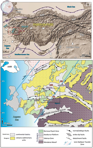
Western Anatolia, which is considered to be an area extending in a N–S direction, is one of the most seismically active and rapidly deforming extensional regions in the world (Bozkurt, Citation2001, Citation2003; Bozkurt & Rojay, Citation2005; Dewey & Şengör, Citation1979; Jackson & McKenzie, Citation1984; Şengör & Yılmaz, Citation1981; Seyitoğlu & Scott, Citation1991).The active tectonics of this region results from westward movement of Anatolia along the right-lateral North Anatolian Fault Zone (NAFZ) and left-lateral East Anatolian Fault Zone (EAFZ). This escape is prevented by the continental thickening in Western Greece. Western Anatolia begins to move towards the west–southwest with counterclockwise rotational movement on the Hellenic Arc due to the east–west compression in the north and central Aegean region (Figure (a)) (Dewey & Şengör, Citation1979; Jackson & McKenzie, Citation1988; Le Pichon & Angelier, Citation1979; McKenzie, Citation1972, Citation1978; Şengör, Görür, & Şaroğlu, Citation1985; Şengör & Yılmaz, Citation1981; Seyitoğlu & Scott, Citation1991). As a result of these movements, Western Anatolia is characterised by supradetachment and rift basins that are bounded by low- and high-angle normal faults, respectively (Bozkurt, Citation2003; Bozkurt & Sözbilir, Citation2004; Dewey & Şengör, Citation1979; Emre, Citation1996; Emre & Sözbilir, Citation1997, Citation2007; Koçyiğit, Yusufoğlu, & Bozkurt, Citation1999; Lips, Cassard, Sözbilir, Yilmaz, & Wijbrans, Citation2001; Özkaymak & Sözbilir, Citation2008; Özkaymak, Sözbilir, Uzel, & Akyüz, Citation2011; Şengör et al., Citation1985; Seyitoğlu, Çemen, & Tekeli, Citation2000; Seyitoğlu & Scott, Citation1991, Citation1992; Seyitoğlu, Tekeli, Çemen, Şen, & Işık, Citation2002; Sözbilir, Citation2001, Citation2002; Uzel & Sözbilir, Citation2008). In general, a series of E–W, NE–SW and NW–SE-trending horst and graben structures dominate depending on this geodynamic control in the region (Bozkurt, Citation2001; Şengör et al., Citation1985; Sözbilir, Citation2002). In addition, recent studies in the western section of the Western Anatolian basins suggest the existence of a NE–SW-trending strike-slip dominated active deformation zone called the İzmir-Balıkesir Transfer Zone (IBTZ) (Okay & Siyako, Citation1991) (Figure (b)). This zone is the result of intermittently reactivated strike-slip and normal faults from Miocene to recent (Özkaymak & Sözbilir, Citation2008, Citation2012; Özkaymak et al., Citation2011; Sözbilir, Inci, Erkül, & Sümer, Citation2003; Sözbilir, Sarι, Uzel, Sümer, & Akkiraz, Citation2011; Sözbilir et al., Citation2008, Citation2009; Uzel & Sözbilir, Citation2008). The eastern part of the IBTZ, separating the West Anatolian Extensional Province (WAEP) in the east from the North Aegean Region (NAR) in the west (Ring, Susanne, & Matthias, Citation1999; Sözbilir et al., Citation2011) is characterised by E-W-trending basins such as the Büyük Menderes, Küçük Menderes and Gediz Graben, with boundaries controlled by E–W-trending high-angle Plio-Quaternary normal faults.
Figure 1. (a) Simplified regional map showing the main neotectonic structures and neotectonic provinces in Turkey and surrounding regions. Note that the Izmir-Balıkesir Transfer Zone (IBTZ) is a structural boundary between the normal fault dominated West Anatolian Extensional Province (WAEP) and strike-slip dominated North Anatolian Region (NAR) (modified from Barka, Citation1992; Bozkurt, Citation2001). Abbreviations: WAEP, West Anatolian Extensional Province; IBTZ, Izmir-Balıkesir Transfer Zone; NAR, North Anatolian Region; NAF, North Anatolian Fault; EAF, East Anatolian Fault; DSF, Dead Sea Fault; BZSZ, Bitlis–Zagros Suture Zone; AT, Aegean Trench; PSA, Pliny–Strabo Arc; CA, Cyprean Arc. (b) simplified tectonic map of Western Turkey showing tectonostratigraphic units and location of study area (redrawn from Özkaymak et al., Citation2011 and reference therein). Abbreviations: MFZ, Manisa Fault Zone; KF, Kemalpaşa Fault; GSF, Gediz Supradetachment Fault; BMSF, Büyük Menderes Detachment Fault; IF, Izmir Fault; SFZ, Seferihisar Fault Zone; OFZ, Orhanlı Fault Zone; EF, Efes Fault; MB, Manisa Basin; KB, Kemalpaşa Basin; GB, Gölmarmara Basin.
The Gediz Graben forms one of the most prominent neotectonic elements of Western Turkey and dissects the Menderes Massif, one of the largest core complex of the World (Figure (b)). This structure, approximately E–W-trending, formed by NNE–SSW extension since Early Miocene (Çiftçi & Bozkurt, Citation2010). It is suggested two main styles of faulting within the Gediz Graben: (i) the main low-angle detachment fault and (ii) high-angle normal faults (Çiftçi & Bozkurt, Citation2010; Cohen, Dart, Akyüz, & Barka, Citation1995; Hetzel, Passchier, Ring, & Dora, Citation1995; Kent, Boulton, Stewart, et al., Citation2016; Koçyiğit et al., Citation1999; Öner & Dilek, Citation2011; Patton, Citation1992; Purvis & Robertson, Citation2004; Sözbilir, Citation2001, Citation2002). According to Bozkurt and Sözbilir (Citation2004), the Gediz Graben is the product of two extensional episodes that displayed differences in stress pattern and deformation styles. The basement rocks, the Menderes Massif, in the footwall of a low-angle normal fault (detachment) and synchronous deposits of Miocene continental clastics in the hanging wall were exhumed during the first period of extension (Çiftçi & Bozkurt, Citation2008, Citation2009; Emre, Citation1996; Emre & Sözbilir, Citation1997; Hetzel et al., Citation1995; Koçyiğit et al., Citation1999; Sözbilir, Citation2001, Citation2002; Yılmaz et al., Citation2000). Then, during the second period, high-angle normal faults formed predominantly E–W-trending basins (Bozkurt & Sözbilir, Citation2006). However, Seyitoğlu et al. (Citation2002) and Çiftçi and Bozkurt (Citation2010) suggested that the detachment faults in the Gediz Graben initiated as a rolling–hinge mechanism by the Early Miocene and then underwent continuous evolution from that time. Besides, it has been determined that the low-angle detachment faulting in the Gediz Graben continued to be active up until ~2 Ma by Buscher et al. (Citation2013). It can be said that this approach also supports the rolling–hinge mechanism for the development of the graben. However, Kent, Boulton, Whittaker, Stewart, and Alçiçek Citation(2016) suggest that this view is broadly supported by other studies into the two-stage evolution of the graben (e.g. Bozkurt & Sözbilir, Citation2004; Koçyiğit et al., Citation1999; Öner & Dilek, Citation2011; Purvis & Robertson, Citation2004).
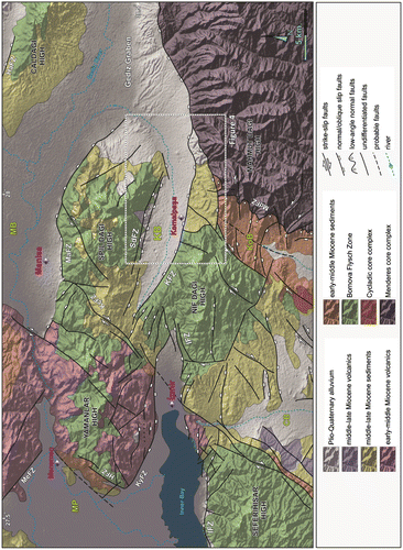
The Gediz Graben splayed into three E–W to NW–SE-trending branches (the Gölmarmara, Manisa and Kemalpaşa; Figure (b)) towards the west. (Emre et al., Citation2005; Özkaymak, Sözbilir, & Uzel, Citation2013). The southernmost branch of these forming the western end of the Gediz Graben is known as the Kemalpaşa Basin (Figures (b) and ). It is specified that the high-angle normal faults bounding the Gediz Graben occur as both main faults and as smaller synthetic/antithetic faults (Çiftçi & Bozkurt, Citation2009) and the Kemalpaşa Fault is a synthetic high-angle structure in the hanging wall of the detachment fault (Emre et al., Citation2005).
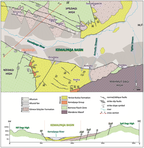
Figure 2. Simplified geological map of the Kemalpaşa Basin and surrounding area with draped on topographic data (compiled from Sözbilir et al., Citation2011; Özkaymak et al., Citation2013; Uzel, Sözbilir, Özkaymak, Kaymakcı, & Langereis, Citation2013). Abbreviations: KB, Kemalpaşa Basin; MB, Manisa Basin; CB, Cumaovası Basin; KOB, Kocaçay Basin; MP, Menemen Plain; MeFZ, Menemen Fault Zone; SdFZ, Spildağı Fault Zone; KFZ, Kemalpaşa Fault Zone; IFZ, Izmir Fault Zone; MdFZ, Mahmutdağı Fault Zone; HaFZ, Halitpaşa Fault Zone.
Recent work by Kent, Boulton, Stewart et al. (Citation2016) suggested that the throw rates on the major high-angle normal fault bounding the southern margin of the Gediz Graben, which the Kemalpaşa Fault is also a part of it, varies from 0.4 to > 1.2 mm/yr along the fault array according to the results they obtained using geomorphic data. They also suggested that the frequency and magnitude of seismic activity in the Gediz Graben probably increased by the linkage of the faults.
Kinematic data show that the faults bounding the Kemalpaşa Basin are an oblique-slip normal fault and when the Kemalpaşa Fault and the Spildağı Fault Zone are considered together, it can be stated that the basin is under the influence of NNE–SSW-trending tension and WNW–ESE-trending compression (Sözbilir et al., Citation2011).
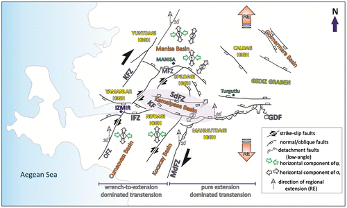
In addition to this, a recent study by Sözbilir et al. (Citation2011) in the western part of the Gediz Graben suggested that the E–W-trending Kemalpaşa Basin was formed by high-angle active normal faults, which corresponds to the second episode in the evolution of the Gediz Graben. Besides, Özkaymak et al. (Citation2013) suggested that there are two distinct deformation zones, including an extension-dominated zone in the middle and eastern parts, and a wrench-dominated transtension zone in the western part. And, they stated that the Kemalpaşa and Manisa basins were characterised by variable wrench-to-extension dominated transtension during the Miocene to Quaternary evolution of the IBTZ (Figure ).
Figure 3. Schematic representation of the tectonic evolution of the Kemalpaşa and surrounding basins. Note that the deformation pattern of Turgutlu is pure extensional, whereas that west of Turgutlu is wrench-to-extension dominated transtension (redrawn from Özkaymak et al., Citation2013).
As summarised above, the Kemalpaşa Basin is a part of the Gediz Graben system which is an area attracting intensive interest by researchers, but there is not any study directly focusing on the tectono-geomorphology of the Kemalpaşa Basin. In this context, we hope that our study will fill this gap in the literature.
2.2. Stratigraphy of the study area
The lithostratigraphic units that outcrop in the Kemalpaşa Basin and surrounding horsts consist of rocks that range in age from Paleozoic to Quaternary. The rock units exposed in the study area have been investigated by dividing them into two main groups: (i) pre-basin-fill units and (ii) basin-fill units (Figure ).
Figure 4. Detailed geological map of the Kemalpaşa Basin (compiled from Sözbilir et al., Citation2011) and geologic cross section showing the stratigraphic and structural relationship of the lithostratigraphic units exposed in the Kemalpaşa Basin. Abbreviations: KF, Kemalpaşa Fault; AkF, Akalan Fault; SuF, Sütçüler Fault; KoF, Kolonkaya Fault; KtF, Kalkancatepe Fault.
The pre-basin-fill units are represented by the metamorphic rocks of the Menderes Massif, the rocks of the Bornova Flysch Zone, and two unconformity-bounded Miocene sequences that overlie these units: the Kemalpaşa Group and the Kızılca Formation. The Menderes Massif, also known as the Menderes Metamorphic Core Complex, made up predominantly of metamorphic rocks belonging to the greenschist facies and these rocks are tectonically overlain by medium-pressure amphibolites facies migmatites and orthogneisses with granitic to granodioritic compositions (Candan et al., Citation2001; Özer & Sözbilir, Citation2003). This unit, observed in south-eastern part of the study area, is separated from the Bornova Flysch Zone by a tectonic contact (Başarır & Konuk, Citation1982; Erdoğan, Citation1990). The Bornova Flysch Zone, outcrops in uplifted blocks of the north and south of the study area, can be described as an olistostromal belt composed of an extremely deformed sedimentary matrix, Maastrichtian–Paleocene in age, which consists of sandstone–shale lithologies and variously size blocks of Mesozoic limestone and serpantinites, cherts and submarine mafic volcanic rocks that are enclosed in the sheared matrix (Erdoğan, Citation1990; Okay et al., Citation1996). This unit, is a NE-trending tectonic zone lying between the Menderes Massif and Izmir-Ankara Suture (Sözbilir et al., Citation2011), has undergone Alpine deformation (Erdoğan, Citation1990; Okay & Siyako, Citation1993). Additionally, it is known that the Bornova Flysch Zone formed in a narrow basin between a strike-slip tear fault bounding a subduction zone and Tethyan ocean (Okay, İşintek, Altıner, Özkan-Altıner, & Okay, Citation2012). This unit outcrops as uplifted blocks in the north and south of the study area.
The Kemalpaşa Group, which is observed in a small part of the study area, initially described as a Neogene detrial sequence by Verdier (Citation1963). The unit comprises the Dereköy and Vişneli formations (Sözbilir et al., Citation2011). According to researchers, the Dereköy Formation is a clastic-dominated sequence derived mostly from marble and schist of the Menderes Massif and limestone, sandstone and ophiolitic rocks of the Bornova Flysch Zone. The Vişneli Formation consists of a fining-upward succession of alluvial fan and sheetflood/lacustrine deposits with interbedded tuffs. The Kızılca Formation unconformably overlies the rocks of the Kemalpaşa Group. This unit consists of alluvial conglomerate, greyish brown sandstone and green-laminated mudstone and thin-to-medium bedded limestone from the base to top (Sözbilir et al., Citation2011).
The basin-fill units, from bottom to top, are the Görece-Sütçüler Formation and alluvium. The Görece–Sütçüler Formation, observed in the southeast of the Armutlu and around of the Sütçüler and Sancaklıiğdecik areas, contains mainly of thick-bedded alluvial fan clastics. The clastics consist of reddish brown, cross-bedded, thick-to-medium bedded sandstone and conglomerate (Sözbilir et al., Citation2011). The age of the unit was determined as Plio-Pleistocene by correlating with other E–W-trending basins in Western Anatolia (Seyitoğlu & Scott, Citation1996). This formation is overlain discordantly by Quaternary alluvium, which forms the modern Kemalpaşa Basin. The alluvium unit is made up of coarse-grained alluvial fan deposits controlled by the normal faults and fine-grained fluvial deposits that are axial river deposits of the Kemalpaşa Plain (Sözbilir et al., Citation2011).
2.3. Basin-bounding faults
The Kemalpaşa Basin developed at the structural border of the Kemalpaşa Fault and the Spildağı Fault Zone (Figure ). The Kemalpaşa Fault is a W-NW-striking normal fault zone which forms the southwestern end of the modern Gediz Graben (Emre & Barka, Citation2000; Emre et al., Citation2005; Sözbilir et al., Citation2011). This fault, lying between the town of Kemalpaşa to the west and the Örenköy district to the east, is approximately 1 km wide and 15 km long (Sözbilir et al., Citation2011). In some studies, it is stated that the length of the fault is more than 15 km (e.g. Emre & Barka, Citation2000; Emre et al., Citation2005). The Kemalpaşa Fault intersects at an along-strike bend with another main fault forming the southern part of the Gediz Graben near Örenköy. These two overstepping main fault segments form a breached relay ramp similar to the one determined in the southern margin of the Gediz Graben south-east of Turgutlu (Çiftçi & Bozkurt, Citation2007; Kent, Boulton, Stewart, et al., Citation2016; Kent, Boulton, Whittaker, et al., Citation2016) and along the Manisa Fault Zone (Bozkurt & Sözbilir, Citation2006; Özkaymak & Sözbilir, Citation2008; Sözbilir et al., Citation2011). The Kemalpaşa Fault juxtaposes footwall rocks of the Bornova Flysch Zone and basin-fill sediments in the north downthrown hanging wall. It also separate Plio-Quaternary graben deposits and Holocene alluvial fans from each other in central and east part (Emre et al., Citation2005). The major fault segments locally display slickensided fault planes that show the Kemalpaşa Fault Zone as an oblique-slip normal faulting dipping on average at 70°N (Sözbilir et al., Citation2011). The paleostress analysis of the fault plane data indicates the presence of the N–S-trending tensional forces for the Kemalpaşa Fault (Sözbilir et al., Citation2011).
The Spildağı Fault Zone, bounding the northern margin of the Kemalpaşa Basin, is a 2 km wide and 12 km long NW-striking fault and it consists of four fault sets parallel to each other (see Figure ) (Sözbilir et al., Citation2011). This fault zone separating the Spil High from the Kemalpaşa Basin is a typical example of a normal fault offering stair step-like morphology regarding to the movement of its parallel fault sets. The Spildağı Fault Zone juxtaposes older basement rocks in the upthrown south footwall with Quaternary basin-fill sediments constituting the north downthrown hanging wall. The paleostress analysis of the Spildağı Fault Zone indicates the NE–SW-trending tensional forces (Sözbilir et al., Citation2011).
3. Methods
The interplay between active tectonics and surface processes causes the formation of measurable geomorphic markers along the faults. And thus, tectonic geomorphology has become one of the principal tools in the study of active tectonics and landscape evolution (Bull, Citation2007; Burbank & Anderson, Citation2001; Keller & Pinter, Citation2002). In the fault-generated mountain front, geomorphic markers such as triangular facets, mountain front lineaments and axial rivers and the quantitative measurements on landscape evolution such as mountain front sinuosity (Smf), asymmetry factor (AF), hypsometric curve, hypsometric integral (HI), valley floor width-to-height ratio (Vf), basin shape (Bs) used to identify the evolution of tectonically active dip-slip normal faults (Burbank & Anderson, Citation2001; Keller, Citation1986; Keller & Pinter, Citation2002; Mayer, Citation1986; Schumm, Dumont, & Holbrook, Citation2002). As there is a lack of studies involving quantitative measurements and analyses of geomorphic indices, the tectonic activity of the Kemalpaşa Basin has not been clarified previously. This study therefore presents geomorphic analysis of the Kemalpaşa Basin to evaluate its tectonic activity. Geomorphic indices data, some of which are related to mountain fronts and others to the landscape in general, were obtained from the footwalls (of the Spildağı High in the north and of the Nif and Mahmutdağı High in the south) and the hanging wall (of the Kemalpaşa Basin). Values were determined by 1:25.000 scale topographic maps that we digitised and 90-m resolution digital elevation model (DEM) imaginaries, and in this way, the presence of active movements along the sides of the Kemalpaşa Basin.
3.1. Mountain front sinuosity (Smf)
Mountain front sinuosity (Smf) is an index reflects the balance between erosional processes that tend to yield irregular and sinuous fronts and tectonic forces that tend to maintain a comparatively straight front (Bull, Citation1977; Bull & McFadden, Citation1977; Keller, Citation1986; Keller & Pinter, Citation2002; Peréz-Peña et al., Citation2010; Silva, Goy, Zazo, & Bardajı́, Citation2003).
Bull (Citation1977) defined mountain front sinuosity as follows:
where Lmf is the length of the mountain front along the range–piedmont junction and Ls is the length of the mountain front along the straight line. In tectonically active mountain, fronts tend to have low values of Smf, as they have not experienced significant range front erosion and responding to active tectonic uplift on a relatively steep fault, keeping the front straight. At less active fronts, where erosional processes overcome tectonic processes, irregular or sinuous fronts with higher values of Smf occur. Some studies indicated that Smf values down to 1.4 are indicative of a tectonically active front (Bull, Citation2007; Keller, Citation1986; Keller & Pinter, Citation2002; Peréz-Peña et al., Citation2010; Silva et al., Citation2003). If the value of Smf higher than 3, it indicates an inactive front in which the initial range–piedmont fault may be more than 1 km from the present erosional front (Bull, Citation2007; Bull & McFadden, Citation1977).
3.2. Asymmetry factor (AF)
The asymmetry factor is typically applied to identify the tectonic control over basin evolution at the regional and local scales (Cox, Citation1994; Hare & Gardner, Citation1985).
The AF was defined by Hare and Gardner (Citation1985) as follows:
where Ar is the area of the drainage basin to the right of the main trunk at the downstream and At is the total area of the drainage basin. Drainage basins with AF value significantly greater or smaller than 50 are known as asymmetric basins. AF values are close to 50 in symmetric basins that have developed under stable conditions with little or no tilting (Hare & Gardner, Citation1985; Keller & Pinter, Citation2002). If AF values are greater than 50, the channel has changed direction towards the downstream left; if values are less than 50, the channel has shifted towards the downstream right (Scotti, Molin, Faccenna, Soligo, & Casas-Sainz, Citation2014).
Pérez-Peña et al. (Citation2010) expressed AF as the absolute value minus 50, with an arrow indicating the asymmetry direction, using the index;
According to relationship, AF absolute values were divided into four asymmetric classes: AF < 5 (symmetric basins), AF = 5–10 (gently asymmetric basins), AF = 10–15 (moderately asymmetric basins) and AF > 15 (strongly asymmetric basins).
3.3. Hypsometric curve and hypsometric integral (HI)
The hypsometric curve and hypsometric integral (HI) are used to provide information about the relative drainage efficiency of a watershed, and they together reflect the evolution of the drainage network. The hypsometric curve, which describes the distribution of elevations within a given area of land, particularly a drainage basin, is obtained by plotting the proportion of the total basin height (relative height) against the proportion of the total area (relative area) (Keller & Pinter, Citation2002; Strahler, Citation1952). The shape of hypsometric curves, which is related to the degree of dissection of the basin, is influenced by the tectonic, climatic and lithological factors controlling the basin landscape (Hurtez, Sol, & Lucazeau, Citation1999; Willgoose & Hancock, Citation1998). Basins of different sizes can be compared using hypsometric curves because hypsometry is independent of basin size and basin height (Keller & Pinter, Citation2002; Peréz-Peña et al., Citation2009). ‘Young’ weakly eroded basins are characterised by convex hypsometric curves, moderately eroded basins depict S-shaped curves, and ‘old’ highly eroded basins are characterised by concave curves.
The hypsometric integral, which is the area under the hypsometric curve, is defined as follows (Keller & Pinter, Citation2002; Pike & Wilson, Citation1971):
HI values vary from 0 to 1. HI values are close to 1 for young geomorphic surfaces that have possibly been impacted by active tectonics. Low values of HI close to 0 are related to older geomorphologies that have been eroded much more.
3.4. Valley floor width-t-height ratio (Vf)
The valley floor width-to-height ratio (Vf) is a geomorphic parameter that reflects the difference between incised (wineglass-shaped) valleys that are V-shaped, compared to broader U-shaped valleys (Bull & McFadden, Citation1977; Keller & Pinter, Citation2002).
This index can be expressed as follows:
where Vfw is the width of the valley, Eld and Erd are the elevations of the left and the right sides of valley, respectively, and Esc is the elevation of the valley floor.
V-shaped valleys, which are associated with rapid in tectonically active settings, indicate low Vf values close to 0, whereas U-shaped valleys, formed in less active areas, show relatively high Vf values (≥1) (Bull & McFadden, Citation1977; Keller & Pinter, Citation2002; Peréz-Peña et al., Citation2010; Silva et al., Citation2003).
3.5. Drainage basin shape index (Bs)
The basin shape index or the elongation ratio (Bs) is defined as the ratio of the length of a drainage basin to its maximum width (Cannon, Citation1976; El-Hamdouni, Irigaray, Fernández, Chacón, & Keller, Citation2008; Ramírez-Herrera, Citation1998). Bs is expressed as follows:
where Bl is the length of the basin, measured from the headwaters point to the mouth and Bw is the width of the basin measured at its widest point. In drainage basins with elongated geometries, associated with relatively higher tectonic activity, the value of Bs tends to be high (Bull & McFadden, Citation1977; Ramírez-Herrera, Citation1998).
4. Results
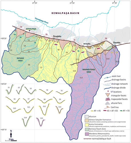
In this section, we present the results of the variations in geomorphic indices that developed in both mountain fronts of the Kemalpaşa Basin and the footwall and hanging wall blocks of the faults bounding the basin. The drainage systems which drained the uplifts in the both sides of the Kemalpaşa Basin involve drainage basins ranging in size from a few square kilometres to larger areas. We determine 30 drainage basins in total, including 15 basins with surface areas in the range 0.9–14 km2 on the north side and 15 basins with surface areas in the range 0.9–51 km2 on the south side (Table ). The drainage basins were named using the symbol ‘N’ for the north and the symbol ‘S’ for the south, with numbers increasing from west to east for both sides. (Figures and ).
Table 1. Morphological properties of the main drainage basins and morphometric indices of analysed drainage basins in the Kemalpaşa Basin.
Figure 5. Schematic map showing the main geomorphic indices calculated at the north side of the Kemalpaşa Basin. AF values are represented by an arrow, indicating sense of asymmetry and by colour indicating the class. Black stars show the locations of the Vf measurements and valley shapes are shown for each point. Bold lines mark geomorphic segments for Smf calculations.
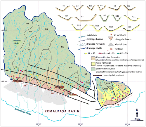
Figure 6. Schematic map showing the main geomorphic indices calculated at the south side of the Kemalpaşa Basin. AF values are represented by an arrow, indicating sense of asymmetry and by colour indicating the class. Black stars show the locations of the Vf measurements and valley shapes are shown for each point. Bold lines mark geomorphic segments for Smf calculations.
The geometry of drainage basins can provide information about the effect of tectonic activity in a region. The drainage basins with elongated geometry indicate that areas that were deformed rapidly (Burbank & Anderson, Citation2001). Considering the sizes of the drainage basins located at the hanging wall blocks of the Kemalpaşa Basin, most of them have predominantly elongated geometry. The shapes of drainage basins are quantitatively described in Table using the basin shape index (Bs). The Bs values are higher than ~2, suggesting that the drainage basins emerging from the base of uplift are long and narrow, and indicative of relatively recent high rates of tectonic activity.
We calculated hypsometric integral (HI) and extracted the hypsometric curves for all of the basins draining the footwalls of the north and south sides of the Kemalpaşa Basin. When hypsometric curves are drawn, the drainage basins comprising south-flowing footwall streams, in ranges N1–N10, were classified as ‘A’ and the other five comprising southeast-flowing footwall streams, in range N11–N15, and were classified as ‘B’ group drainage basins for the northern part of the Kemalpaşa Basin because they are limited by different structural lines and thus they display a different extension from each other (Figure ). All of the drainage basins located on the uplifted footwall block in the south side are limited by the Kemalpaşa Fault (Figure ). Therefore, the hypsometric curves in the northern side have been shown in two graphics belonging to A and B, and the curves in the southern side have been shown in a single graphic (Figure ). These indexes have been utilised to obtain a measure of the relative topographic development in many studies (Keller & Pinter, Citation2002). The convex hypsometric curves indicating high values of HI are suggestive of younger geomorphic surfaces characterise weakly eroded basins, while the concave curves with lower HI values are suggestive older landscapes with more long-term erosion (Hurtez et al., Citation1999; Keller & Pinter, Citation2002). Therefore, lithologic factors should be taken into consideration as well as tectonic control in approaches related to hypsometric index. The drainage basins in the north side of the Kemalpaşa Basin have a lithology comprising Pleistocene alluvial fan clastics and Miocene non-marine sediments. Some of these basins contain the limestone blocks belonging to the Bornova Flysch Zone. And also, the drainage basins in the south side consist of Pleistocene and Miocene sedimentary rocks, Bornova Flysch Zone and Menderes methamorphics (Figures and ). Although the drainage basins are affected by the same fault, they don’t display the similar shapes of hypsometric curve because they contain lithologically different rock types.
Figure 7. Hypsometric curves of the studied drainage basins on both sides of the Kemalpaşa Basin. A and B show curves in the north side, C and D show curves in the south side. Locations of the basins are indicated in the schematic map in Figure and .
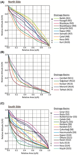
In the north side of the Kemalpaşa Basin, the drainage basins denoted as N1, N2, N4, N6 and N9 have convex hypsometric curves and the highest HI values (0.65 > HI > 0.53). HI values of catchments with straight or S-shaped hypsometric curves range from 0.41 and 0.38 (N3, N7 and N10). The remaining drainage basins (N5, N8, N11, N12, N13, N14 and N15) have low values of HI less than 0.30, showing concave hypsometric curve (Table and Figure ). In general, 33% of the hypsometric curves are convex and 26% of the curves are S-shaped or straight in the north side.
In the south side of the Kemalpaşa Basin, the HI values of drainage basins denoted as S13, S14 and S15 are in the range of 0.54–0.67 and have convex hypsometric curve. All of these basins are located where on the Kemalpaşa Fault has an eastward strike. Catchments with straight or S-shaped curves (S1, S2, S6 and S12) have HI values ranging from 0.48 to 0.33. The remaining drainage basins (S3, S4, S5, S7, S8, S9, S10 and S11) have concave hypsometric curve with low HI values (HI < 0.28) (Table and Figure ).
According to the results, it is noted that there are convex hypsometric curves with high HI values (HI > 0.55), indicating relatively high-relief landscapes in some certain areas which cover more resistant sedimentary rocks than others or in areas where generally older rocks are located in the north and south sides of the Kemalpaşa Basin. These relatively high values and convex curves can be suggestive of recent topographic development related to active fault movement in the region, but these results are not particularly useful in delineating details of change along the mountain uplift. The values and plotted curves also suggest that the evidence of erosional processes may be close to steady state between uplift and erosion.
On the other hand, S-shaped hypsometric curves, also known as complex hypsometric curves, may be associated with active tectonics together with litho-geological controls related to ‘rejuvenation’ process at the foot or head of streams (Giaconia, Booth-Rea, Martinez-Martinez, Azañon, & Peréz-Peña, Citation2012). Basins showing such curves were determined in the studied area (Figure ). The drainage basins denoted as N3 and N10 in the north, and S1, S2 and S12 in the south have smooth S-shaped curves. The hypsometric curves of these basins beginning as concave curve turn into the convex curve. This may be a result of a new change process in the condition of erosion resulting from the active movements along the both sides of the Kemalpaşa Basin.
The values of asymmetry factor (AF) which are used to detect tectonic tilting transverse to the flow of a drainage basin (Cox, Citation1994; Keller & Pinter, Citation2002) were calculated for all basins in the both sides. The values are shown Table and the direction of tilting for each of the basin is marked on Figures and . As the AF value depart from the central value of 50, the influence of tectonic tilting on the asymmetry of the basins increases. In the both sides of the Kemalpaşa Basin controlled by the faults, the AF values are greater or lower than value of 50. Results of asymmetry factor (AF) vary from 11 to 75 in the north side and vary from 39 to 73 in the south side (Table ). In this study, we have classified the AF values into three classes in a manner similar to that of the studies of Özkaymak and Sözbilir (Citation2012), (1) 45 ≤ AF ≤ 55 symmetric basins (shown by the pink two-headed arrows, Figures and ), (2) AF > 55 asymmetric eastward-tilting basins (shown by the green arrows, Figures and ), and (3) AF < 45 asymmetric west–southwestward tilting basins (shown by the yellow arrows, (Figures and ). Most of basins in the both sides of the Kemalpaşa Basin tend to be predominantly asymmetric pattern showing westward-tilt direction, while some of the basins indicate a tilting to the east and a few of them tend to be symmetric pattern showing no preferred tilt direction (Figures and ).
Table 2. Smf values for the geomorphic segment differentiated for study (see Figures and for locations).
Additionally, the AF values were categorised into four classes according to the classification of Pérez-Peña et al. (Citation2010): AF < 5 (symmetric), AF = 5–10 (slightly asymmetric), AF = 10–15 (moderately asymmetric) and AF > 15 (strongly asymmetric). The drainage basins of the north side show mostly strongly asymmetric pattern. Forty-six per cent of AF values are greater than 15 and 27% of the values are in the range of 10–15. In the south side, moderately asymmetric and slightly asymmetric patterns are relatively dominant, although there is a balanced distribution between the values calculated for the basins (Table ).
We used valley width-to-height ratio (Vf) and mountain front sinuosity (Smf) to analyse the geometry of the mountain front. The Vf reflects the difference between V-shaped valleys actively downcutting in response to active uplift and U-shaped valleys (broad-floored) with low uplift rates. The transverse valley profiles which used to determine Vf are located ~250 m upstream of the mountain front for smaller drainage basins, and in large drainage basins, the valley profiles are located at ~250 and ~500 m upstream of the mountain front, in a manner similar to those in studies by Ramírez-Herrera (Citation1998), Bull (Citation2007) and Özkaymak and Sözbilir (Citation2012). The Vf values calculated along the fault zone bounding the north side vary in the range of 0.21–1.1 (Table ). The five basins located at the easternmost have high Vf values (Vf > 1), with broader valley shape (Figure ), the other basins have relatively smaller Vf values less than 1. In the south side of the Kemalpaşa Basin, the Vf values along the fault zone vary from 0.043 to 0.92 (Table ). All the Vf are low for the south side. In addition, the lowest values of Vf (less than 0.2) belong to the valley profiles located at the easternmost part where the Kemalpaşa Fault is bent. In general, drainages in all basins on this, side are deeply incised V-shaped valley profiles suggesting active fronts (Figure ).
The mountain fronts sinuosity (Smf) which is the most imformative index about the mountain front geometry was calculated for both fault-bounded sides. In the north side, the Smf values are, respectively, 1.29, 1.32 and 1.564 from the west to the east along the determined geomorphic segments (Table , Figure ). It is seen that the Smf values systematically increase towards the east. The Smf values in the south side are generally much lower than the values in the north side. In the south side, the Smf values were, respectively, calculated as 1.147, 1.304, 1.286 and 1.122 from the west to the east along the determined geomorphic segments (Table , Figure ). The lowest values of Smf are found in the easternmost geomorphic segment. In general, both sides of the Kemalpaşa Basin have relatively low Smf values (less than 1.4) suggesting that these mountain fronts are tectonically active.
A linear mountain front and large facets that are typically created by rapid hanging wall subsidence and footwall uplift (Burbank & Anderson, Citation2001) are observed along the faults bounding the sides of the Kemalpaşa Basin. Active normal fault-generated mountain fronts frequently display triangular facets interpreted as variably degraded remnants of the footwall scarp (Wallace, Citation1978). And also, Wallace (Citation1978) noted that the classical use of term triangular facet is somewhat misleading, in that many facets are trapezoids or more complex features that increases in complexity through time because of erosion of the mountain front, and stated that such faceted spurs evolved through time as a direct response to uplift and erosion. Both types of the facets have been observed on the fault ranges bounding the Kemalpaşa Basin.
The size and slope of triangular facets provide information about the fault activity and show how the fault deformation is controlled. Wallace (Citation1977) point outs that if the slope of a facet is 35°, this is controlled by debris developing with faulting and if the slopes of facets varied from 25° to 35°, the surface degrade debris and wash-controlled. And also, he indicates that slopes between 18° and 22° may present some form of stability in the erosional process, but an explanation for this has not been determined. The slopes of the triangular facets determined on both mountain fronts of the Kemalpaşa Basin were calculated using the height difference and length of triangular surfaces at the base along the north and south sides. In the north side, the slopes of triangular facets vary from 22° to 28° along the west section and the values decreasing towards the east are in the range of 12°–16°. The slopes of triangular facets range from 18° to 32° along the southern mountain fronts. The values are between 26° and 28° in the west section, they fall up to 18° towards the central section and vary from 25° to 32° in the east section. These data obtained from the triangular facets show that the deformation in the mountain fronts continue washing- and/or debris-controlled with mechanism of the faulting. The slopes of facets beginning to develop after the faulting are related to the lithologic properties of the facets. The lithology of the surface exposed with the faulting can change the erosion rate. The facets which formed in the structural borders of the Kemalpaşa Basin are generally composed of Pleistocene and Miocene sedimentary rocks. In the areas, where the slope values are low, the facets consist of Miocene sediments and also Bornova Flysch Zone in some part. Facets with higher slope values roughly are on Pleistocene deposit which is made up of alluvial fan clastics and conglomerates. Therefore, it can be said that the slope change in the facets developed on the same fault zone result from the differences in the lithology existing along the fault. It should be noted that the faulting in the Kemalpaşa Basin continues with erosional process.
The formation of the Kemalpaşa Fault commenced with interaction between and along-strike linkage of neighbouring faults. As interaction between two fault segments increased with overlap, it resulted in a relay ramp that transferred displacement between them. The breaching of this relay ramp then resulted in a single through-going fault that accommodated extension in the NE–SW direction. The relay ramp has a steep front face and a gentle back slope. The face of the block is the fault plane. The hills, representing monadnocks, on the mature block rise above the level of the back slope, and there are valleys raised to hanging position but not carrying any drainage. When stream notches are first cut in the scarp face, the facets on the front of the scarp are trapezoidal. They may become triangular as they increase in number with the approach of maturity.
5. Discussion
This study centres on the assessment of active tectonics using geomorphological investigations along the both sides of the Kemalpaşa Basin. Variations in the morphometric calculations of the fault-defined mountain fronts that form the Kemalpaşa Basin provided the basis for the effect of tectonic activity. The results of morphometric indexes calculated in this study suggest that the faults bounding the Kemalpaşa Fault from both sides are tectonically active. This approach supports the view of some studies by Emre and Barka (Citation2000), Emre et al. (Citation2005), Sözbilir et al. (Citation2011), etc., which suggested that the Kemalpaşa Fault is active. This fault is also marked as an active fault in the 1/250.000 scale Active Fault Map of Turkey by the MTA (Emre, Özalp, & Duman, Citation2011). In addition to this, there is no study on whether the Spildağı Fault Zone is active or not. But, Sözbilir et al. (Citation2011) mapped this fault zone as a fault cutting the Quaternary alluvial fans in their study. On the basis of these views and approaches, the tectonic activity of the Kemalpaşa Basin is discussed in following sub-headings in the directions of the data obtained and related references.
5.1. The relationship between active tectonic and erosional process on the basin development
The erosional stage of the basin is determined the convexity of the hypsometric curve and hypsometric integral (HI) value related to curve shape (Ohmori, Citation1993; Strahler, Citation1952). Less-eroded basins yield convex shapes with higher HI values and the shape of this curve is related to the degree of dissection of the basin, i.e. erosional stage (Keller & Pinter, Citation2002). And also, it is known that the shape of hypsometric curves (and related HI values) provides valuable information about tectonic, climatic and lithological factors controlling catchment landscape (Moglen & Bras, Citation1995; Willgoose & Hancock, Citation1998). In general, there is a positive correlation between curve shapes and their HI values for the both sides of the Kemalpaşa Basin. Lithologic factors are very similar for drainage basins showing similar curve in both sides. In addition to this, it must be considered that the most of drainage basins involve multiple units. The drainage basins indicating concave hypsometric curve with low HI values are located on clastic sediments which can be easily eroded in the both sides of the Kemalpaşa Basin. In the north side, HI values increase westwards and hypsometric curve relatively turn into convex shape. This can be due to the existence of limestones which are less eroded than clastics within the drainage basins. In the north side, all of the drainage basins showing concave hypsometric curve are located on sedimentary rocks of Miocene age which generally consists of non-marine clastic rocks including alluvial conglomerate, sandstone and mudstone, and some of these basins are located on Pleistocene rocks comprising alluvial fan clastics. Some of the convex hypsometric curve with high HI values belongs to the basins which drained Mesozoic limestones in the west section. It is likely that the drainage basins have showed the convex hypsometric curve because they are located on less eroded rocks. The other drainage basins showing convex are located on the east section. They contain clastic sediments same with the northern side. Although some of these basins have quite similar lithology with the basins showing concave curve in the northern side, having shown the convex curve on this side suggest the presence of tectonic effect. It is seen that the erosional processes are effective on the topographic shape of the catchments in the studied area. But, both mountain fronts of the Kemalpaşa Basin are fault-controlled and these faults have been active, having uplifted footwalls, where the catchments are located. Thus, the convex hypsometric curves which are typical for youthful stages of maturity in some sections of mountain fronts (especially, the east section of the southern side) and high-relief landscapes can be attributed to tectonic factors in this study. On the other hand, the tilting of the drainage basins with similar lithology on the surrounding horsts of the Kemalpaşa Basin indicates that their asymmetry patterns may be associated with tectonic activity. Therefore, we suggest that the geomorphologic formation of the basin developed with tectonic and erosional processes.
5.2. Geomorphic evidence of tectonic activity: facet development
Wallace (Citation1978) assumed that facets are eroded fault scarps and that geomorphic changes of facets are time dependent. According to this, young trapezoidal facets occur shortly after onset of faulting, and then development of triangular facets begins with erosion. When tectonic activity decreases, facets with lower slope occur with more erosion. We identify triangular and trapezoidal facets in both mountain fronts of the basin in accordance with these definitions (Figure ), and also draw a simple model showing the relationship between facet development and tectonic activity for the study area (Figure ). In the northern side, all of the facets are triangular and facet slopes decrease from the west to the east. This geomorphic change on facets indicates that tectonic activity decreases towards the east and that erosion produces relatively low-relief piedmonts through time. So, it can be said that uplift rate of the west section is higher as compared to the east in the northern mountain front, as the effect of tectonic activity is high in the west section. In the southern side, we identify trapezoidal facets as well as triangular facets. All of triangular-shaped facets with different slope angle are observed along the west and central part of the mountain front. Facets with trapezoidal shaped are located on the eastern part. The transformation of young trapezoidal facets to older triangular facets along the Kemalpaşa Fault can be interpreted as the change of fault activity. First, the facets with trapezoidal shaped occur shortly after faulting and they transformed into triangular shape by erosional processes through time. So, trapezoidal facets are morphologic structures which show that the mountain front actively uplifted. According to this, the trapezoidal facets observed along the east part of the Kemalpaşa Fault indicate that the uplift rate is higher in this front than the others.
Figure 8. Google Earth image showing the trapezoidal facets observed along the Kemalpaşa fault.
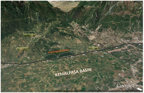
Figure 9. Geologic evolution of the Kemalpaşa Fault. (a) En échelon fault tips propagating towards overlap during the NE-SW crustal extension. (b) Breaching of the relay ramp and formation of a new connecting normal fault. (c) Block diagram showing basinward younging of the active fault segments. Note the presence of triangular facets along the older and inactive mountain front and trapezoidal facets along the younger mountain front.
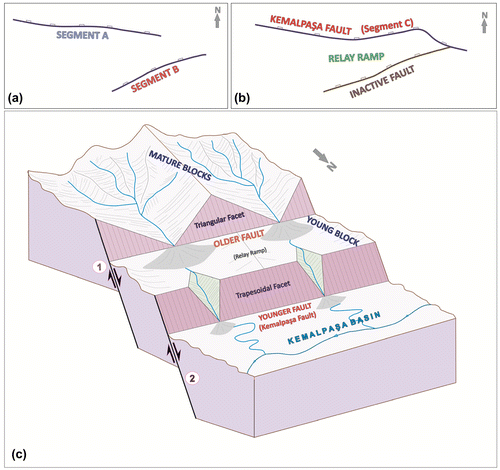
Indeed, it is difficult to see both trapezoidal and triangular facets along the same mountain front formed within a fault zone. This case may be due to another reason except faulting mechanism generates the mountain front. Therefore, the other factors such as rock resistance, climate, erosional processes and rate of faulting should be considered in such mountain fronts where both facets can be observed. Facets may remain trapezoidal if uplift rate is high and rocks in footwall are resistant.
In here, we suggest that the transformation of trapezoidal facets to triangular facets results from the change of relative effect of the tectonic activity along the Kemalpaşa Fault. It can be said that the uplift rate is relatively higher in the eastern part where trapezoidal facets are observed. So, this part of the Kemalpaşa Fault is more rapidly deforming part that has potentially seen a more recent development.
Besides, another geomorphic signature noticed here about facets is that older triangular facets have been behind young trapezoidal facets. This is important as it indicates that the fault generating older mountain front in the back begin to lose its activity through time. According to our assumption, this fault combines with the Kemalpaşa Fault. Increasing of interaction between two faults results in a relay ramp, that transfers displacement between them. As a result of this, the fault in the back has become inactive. Therefore, facets developing on the older fault plane are triangular, as the maturity of blocks increases with erosional processes. And, facets in the young mountain front formed by the Kemalpaşa Fault are trapezoidal. The simple model presented in Figure summarises the relationship between development of facet and fault activity in this study.
Briefly, facets of the studied area indicate that the faults bounding the Kemalpaşa Basin are active, but it can be said that fault activities and uplift related to them vary from part to part.
5.3. The relative degree of tectonic activity in the mountain front
Bull and McFadden (Citation1977) used a combination of Vf and Smf to provide quantitative information about the relative degree of tectonic activity of the mountain fronts controlled by active faults. They suggested three main activity classes (1–3) and described ‘active fronts’ (class 1) as those with low values of Smf (<1.6) and Vf (<0.5) indexes. In the Kemalpaşa Basin, the Vf and Smf values obtained for both sides are lower than the specified values by authors. Therefore, it can be said that both sides bounding the Kemalpaşa Basin are active fronts. In addition, these values show that the relative degree of tectonic activity in south side is higher than that of the north side. On the other hand, similar morphometric analyses were done in the Spildağı High Ranges, which are controlled by the Manisa Fault (Özkaymak & Sözbilir, Citation2012), and Honaz Dağı High, which is controlled by the Honaz Fault (Özkaymak, Citation2015). And the results of morphometric analysis in the Kemalpaşa Basin show some similarities with analyses in these two areas. Faults in these areas are active normal faults which have been formed under an N–S trending extensional regime like faults bounding the Kemalpaşa Basin. Vf values calculated for the Kemalpaşa Basin are low, corresponding to V-shaped valleys in the mountain fronts, similar to these two regions. And also, the presence of V-shaped valleys in the study area suggests a high rate of incision associated with tectonic activity. Values of Smf calculated for the Manisa Fault Zone and The Honaz fault are also similar to the Smf values obtained for both sides of the Kemalpaşa Basin, all values indicating tectonically active mountain fronts. The similar results of the geomorphic indices show that the degree of tectonic effect of faults in these three areas represents characteristic values of active dip-slip normal faults in Western Anatolia.
5.4. Uplift rate
Rockwell et al. (Citation1984) suggest that the uplift rates associated with each of the activity classes and that the uplift rates close to 0.4–0.5 mm/y were sufficient to keep Smf values down to 1.4 and Vf values down to 1, to generate active fronts (class 1). Although the uplift rate has not been determined numerically for the Kemalpaşa Basin in the scope of this study, it can be relatively suggested that the uplift rate may be in this interval or close to this values. On the other hand, when dealt with in regional scale, some specific fault motion rates have been recorded in recent studies performed in the Gediz Graben. Buscher et al. (Citation2013) suggested that the low-angle detachment faulting in the Gediz Graben had a slip rate of 4.3 (±0.3/–1.2) mm/yr. Recent studies by Kent, Boulton, Stewart, et al. (Citation2016), Kent, Boulton, Whittaker, et al. Citation2016) derived time averaged rates of fault motion from 0.4 mm/yr along the strike of the Gediz Graben. In addition, Özkaymak et al. (Citation2011) determined minimum slip rates in the range of about 0.1–0.3 mm/yr in different sectors of Manisa Fault Zone. Similarly, a minimum slip rate was determined in the range of 0.15–0.38 mm/yr for the Honaz Fault. Therefore, we can suggest a similar uplift rate to the rates of the Manisa and Honaz regions due to similarities in the morphometric analyses. Accordingly, it can be said that the uplift rate in the Kemalpaşa Basin may vary in the range of 0.1–0.5 mm/yr, when all theoretical informations combined. However, this assumption needs to be supported by extra structural data which will gather on the faults bounding the basin and by age data for an accurate result.
5.5. Seismicity
Some studies such as by Tocher (Citation1958), Wells and Coppersmith (Citation1994) suggested that earthquake magnitude may be correlated with fault length and displacement. Wells and Coppersmith (Citation1994) indicated the empirical relationship between the moment magnitude (Mw) and fault length for different fault types. According to the researchers, a 15-km-long normal fault is capable of generating an earthquakes with magnitudes of 6.4–6.7 (Mw = 4.86 + 1.32*log Lr,normal, ± 0.34*nd; L is rupture length (km) and nd is the number of standard deviations according to researchers). Similarly, Pavlides and Caputo (Citation2004) suggested an earthquake with a magnitude of 6.5 for a fault of this length (Ms = 0.90*log L + 5.48; L is rupture length). Especially taking into account that the Kemalpaşa Fault is 15-km, it can be said that the Kemalpaşa Fault may produce an earthquake with a minimum magnitude of 6.4. This value we suggest complies with similar studies by Özkaymak and Sözbilir (Citation2012), discussed activity of Manisa Fault, and by Özkaymak (Citation2015), discussed activity of the Honaz Fault (6.5–7 for the Manisa Fault and 6.7 for Honaz Fault). On the basis of all approaches, we can say that the faults bounding the Kemalpaşa Basin will produce earthquakes with magnitudes ranging from 6.0 to 6.7. According to these, it is possible that the Spildağı Fault Zone, will produce smaller earthquakes as compared with the Kemalpaşa Fault because the length of it is less than 15 km. Although there are recorded historical and instrumental earthquakes in the study area, it is not known exactly that the earthquakes are produced by which of the fault bounding the Kemalpaşa Basin. And also, the data are not sufficient to estimate the recurrence interval of earthquakes. Moreover, especially the Kemalpaşa Fault is a fault which passes through the centre of Kemalpaşa town where the density of settlement is high. Because it is very close to Izmir city, it should be taken into consideration that an earthquake that may occur in the Kemalpaşa Basin will increase earthquake damages.
6. Conclusions
The Kemalpaşa Basin is a Quaternary Basin that presents a typical asymmetric graben structure. This basin trends approximately NW-SE, expands towards the east, and makes a slight curve towards the north-east at the eastern edge. The width of the basin floor ranges from 3.5 to 6 km. The average elevation of the basin floor measured ~100 m at the widest point and ~170 m at the narrowest point. Abrupt topographic uplifts were observed along the sides of the Kemalpaşa Basin. The uplifts increase towards the north-west direction in the north side and towards the east–southeast direction in the south side of the basin. The average elevation value at the northern edge is 1250 m, but this value reaches up to 1400 m at the southern edge. Additionally, the slope on the northern margin of the basin is lower than that on the southern margin. This is probably a result of the differences in the activities of the faults bounding the both side of the Kemalpaşa Basin and erosional processes cooperating with this tectonic structure. In the Kemalpaşa Basin, an axial river is represented by Kemalpaşa (Nif) river that follow the trend of the faults bounding the basin. According to morphometric calculations, the mean channel gradient of the axial river maintains a generally uniform slope of 0.72 (%) with a channel sinuosity 1.18 along the Kemalpaşa Basin. These values indicate that the axial river has a meandering-to-braided pattern, which represents the mixed-load channel pattern according to the channel-type classification (Schumm, Citation1986).
In this study performed to identify the relative degree of tectonic activity in the Kemalpaşa Basin using geomorphological approaches, we conclude that the Kemalpaşa Basin has been shaped under the control of NNE–SSW trending extensional forces compatible with regional tectonic regime in Western Anatolia. The neotectonic indices such as triangular and trapezoidal facets, mountain lineament patterns, drainage basin geometries suggest a relatively high degree of tectonic activity in the Kemalpaşa Basin and the oblique-slip normal faults bounding the basin from the north and south are highly active. The Quaternary landscape evolution of the basin was controlled by these active faults and erosional processes operating together. All geomorphic results indicate that the southern side of the basin is more active than the northern side. This difference which can be caused the different uplift rates in both sides provides that the Kemalpaşa Basin becomes a typical asymmetric graben. The basin-bounding active faults, especially the Kemalpaşa Fault to the south, are a potential threat in terms of larger earthquakes. Therefore, the activities of the faults in past and the recurrence intervals of them should be revealed with detailed paleoseismological studies.
Disclosure statement
No potential conflict of interest was reported by the authors.
Acknowledgements
This work was part of a MSc. Thesis undertaken by Çiğdem TEPE at the Institute of Natural and Applied Sciences, Dokuz Eylul University, Turkey. We would like to sincerely thank to Edward A. Keller for his scientific support on and constructive suggestions on this work. And also, we appreciate helpful comments by Sarah J. Boulton and anonymous referee. The paper was edited by Editage, an English language editing service. And, we dedicate this paper to the precious memory of Şafak Sevgi TEPE, who was one of the special people in this World.
References
- Barka, A. A. (1992). The North Anatolian fault zone. Annales Tectonicae, VI, 164–195.
- Başarır, E., & Konuk, Y. T. (1982). Gümüldür yöresinin kristalin temeli ve allokton birimleri [Crystalline basement and allochthon units of Gümüldür region]. Türkiye Jeoloji Kurultayı Bülteni, 24, 1–6.
- Bishop, P. (2007). Long-term landscape evolution: Linking tectonics and surface processes. Earth Surface Processes and Landforms, 32, 329–365.10.1002/(ISSN)1096-9837
- Bozkurt, E. (2001). Neotectonics of Turkey-a synthesis. Geodinamica Acta, 14, 3–30.10.1080/09853111.2001.11432432
- Bozkurt, E. (2003). Origin of NE-trending basins in western Turkey. Geodinamica Acta, 16, 61–81.10.1016/S0985-3111(03)00002-0
- Bozkurt, E., & Rojay, B. (2005). Episodic, two-stage Neogene extension and short-term intervening compression in western Anatolia: Field evidence from the Kiraz Basin and Bozdag Horst. Geodinamica Acta, 18, 295–312.
- Bozkurt, E., & Sözbilir, H. (2004). Tectonic evolution of the Gediz Graben: Field evidence for an episodic, two-stage extension in western Turkey. Geological Magazine, 141, 63–79.10.1017/S0016756803008379
- Bozkurt, E., & Sözbilir, H. (2006). Evolution of the large-scale active Manisa fault, southwest Turkey: Implications on fault development and regional tectonics. Geodinamica Acta, 19, 427–453.10.3166/ga.19.427-453
- Brookfield, M. E. (1998). The evolution of the great river systems of southern Asia during the Cenozoic India-Asia collision: Rivers draining southwards. Geomorphology, 22, 285–312.10.1016/S0169-555X(97)00082-2
- Bull, W. B. (1977). Tectonic geomorphology of the Mojave Desert, California (U.S. Geological survey Contact Report 14-0-001-G-394. Office of Earthquakes). Volcanoes and Engineering (188 p). Menlo Park, CA.
- Bull, W. B. (2007). Tectonic geomorphology of mountains: A new approach to paleoseismology (p. 328). Oxford: Wiley-Blackwell.10.1002/9780470692318
- Bull, W. B., & McFadden, L. D. (1977). Tectonic geomorphology north and South of the Garlock fault, California. In D. O.Doehering, (Ed.), Geomorphology in Arid regions. Proceedings at the Eighth Annual Geomorphology Symposium (pp. 115–138). Binghampton, NY: State University of New York.
- Burbank, D. W. & Anderson, R. S. (2001). Tectonic geomorphology. Malden, MA: Blackwell Science.
- Buscher, J. T., Hampel, A., Hetzel, R., Dunkl, I., Glotzbach, C., Struffert, A., & Ratz, M. (2013). Quantifying rates of detachment faulting and erosion in the central Menderes Massif (western Turkey) by thermochronology and cosmogenic 10 Be. Journal of the Geological Society, 170, 669–683.10.1144/jgs2012-132
- Candan, O., Dora, O. Ö., Oberhanslı, R., Çetinkaplan, M., Partzsch, J. H., Warkus, F. C., & Dürr, S. (2001). Pan-African high-pressure metamorphism in the Precambrian basement of the Menderes Massif, western Anatolia, Turkey. International Journal of Earth Science, 89, 793–811.
- Cannon, P. J. (1976). Generation of explicit parameters for a quantitative geomorphic study of Mill Creek drainage basin. Oklahoma Geology Notes, 36, 3–16.
- Chen, Y. C., Sung, Q. C., & Cheng, K. Y. (2003). Along-strike variations of morphotectonic features in the Western Foothills of Taiwan: Tectonic implications based on stream-gradient and hypsometric analysis. Geomorphology, 56, 109–137.10.1016/S0169-555X(03)00059-X
- Cohen, H. A., Dart, C. J., Akyüz, H. S., & Barka, A. (1995). Syn-rift sedimentation and structural development of the Gediz and Buyuk Menderes graben, western Turkey. Journal of the Geological Society, 152, 629–638.10.1144/gsjgs.152.4.0629
- Cox, R. T. (1994). Analysis of drainage-basin symmetry as a rapid technique to identify areas of possible Quaternary tilt-block tectonics: An example from the Mississippi Embayment. Geological Society of America Bulletin, 106, 571–581.10.1130/0016-7606(1994)106<0571:AODBSA>2.3.CO;2
- Çiftçi, N. B., & Bozkurt, E. (2007). Anomalous stress field and active breaching in relay ramps: A field example from Gediz Graben, SW Turkey. Geological Magazine, 144, 687–699.
- Çiftçi, N. B., & Bozkurt, E. (2008). Folding of the Gediz Graben fill, SW Turkey: extensional and/or contractional origin. Geodinamica Acta, 21, 145–167.
- Çiftçi, N. B., & Bozkurt, E. (2009). Structural evolution of the Gediz Graben, SW Turkey: Temporal and spatial variation of graben basin. Basin Research, 22, 846–873. doi:10.1111/j.1365-2117.2009.00438.x.
- Çiftçi, N. B., & Bozkurt, E. (2010). Structural evolution of the Gediz Graben, SW Turkey: Temporal and spatial variation of the graben basin. Basin Research, 22, 846–873.
- Dewey, J. F., & Şengör, A. M. C., (1979). Aegean and surrounding regions: Complex multiplate and continuum tectonics in a convergent zone. Geological Society of America Bulletin, pt. I, 90, 84–92.10.1130/0016-7606(1979)90<84:AASRCM>2.0.CO;2
- El-Hamdouni, R., Irigaray, C., Fernández, T., Chacón, J., & Keller, E. A. (2008). Assessment of relative active tectonics, southwest border of the Sierra Nevada (southern Spain). Geomorphology, 96, 150–173.10.1016/j.geomorph.2007.08.004
- Emre, Ö., & Barka, A. A. (2000). Gediz Grabeni-ege Denizi arasının (İzmir yöresi) aktif fayları. In Batı Anadolu'nun Depremselliği Sempozyumu (BADSEM-2000) (pp. 131–132). İzmir, Bildiriler Kitabı.
- Emre, Ö., Özalp, S., Doğan, A., Özaksoy, V., Yıldırım, C., & Göktaş, F. (2005). İzmir vey akın çevresinin diri fayları ve deprem potansiyelleri [The active faults and earthquake potentials of İzmir and surrounding area] ( Report No. 10754). Ankara: General Directorate of Mineral Research and Exploration.
- Emre, Ö., Özalp, S., & Duman, T. Y. (2011). 1:250.000 scale active fault map series of Turkey, İzmir (NJ 35-7) Quadrangle. Serial number: 6, General Directorate of Mineral Research and Exploration, Ankara, Türkiye.
- Emre, T. (1996). Gediz Grabeni’nin tectonik evrimi (Geology and tectonics of gediz Graben). Turkish Journal of Earth Sciences, 5, 171–185.
- Emre, T., & Sözbilir, H. (1997). Field evidence for metamorphic core complex, detachment faulting and accommodation faults in the Gediz Graben and Büyük Menderes Graben, western Turkey. In International Earth Sciences Collequium on the Aegean Region (IESCA-5), Abstracts Book (Vol. 1, pp. 73–94). İzmir.
- Emre, T., & Sözbilir, H. (2007). Tectonic evolution of Kiraz Basin, Küçük Menderes Graben: Evidence for compression/uplift-related basin formation overprinted by extensional tectonics in west Anatolia. Turkish Journal of Earth Sciences, 16, 441–470.
- Erdoğan, B. (1990). İzmir-Ankara Zonu’nun İzmir ve Seferihisar arasındaki bölgede stratigrafik özellikleri ve tektonik evrimi [The stratigraphic features and tectonic evolution of İzmir-Ankara zone between İzmir and Seferihisar region]. TPJD Bülteni, 2, 1–20.
- Giaconia, F., Booth-Rea, G., Martinez-Martinez, J. M., Azañon, J. M., & Peréz-Peña, J. V. (2012). Geomorphic analysis of the Sierra Cabrera, an active pop-up in the constrictional domain of conjugate strike-slip faults: The Palomares and Polopos fault zones (eastern Betics, Spain). Geomorphology, 580, 27–42.
- Giaconia, F., Booth-Rea, G., Martínez-Martínez, J. M., Azañón, J. M., Pérez-Peña, J. V., Pérez-Romero, J., & Villegas, I. (2012). Geomorphic evidence of active tectonics in the Sierra Alhamilla (eastern Betics, SE Spain). Geomorphology, 145–146, 90–106.10.1016/j.geomorph.2011.12.043
- Hare, P. W., & Gardner, T. W. (1985). Geomorphic indicators of vertical neotectonism along converning plate margins, Nicoya Peninsula, Costa Rica. In M. Morisawa & J. T. Hack (Eds.), Tectonic geomorphology (pp 75–104), Proceedings of the 15th Annual Bighampton Geomorphology Symposium. Boston, MA: Allen&Unwin.
- Hetzel, R., Passchier, C. W., Ring, U., & Dora, Ö. O. (1995). Bivergent extension in orogenic belts: The Menderes massif (southwestern Turkey). Geology, 23, 455–458.10.1130/0091-7613(1995)023<0455:BEIOBT>2.3.CO;2
- Hurtez, J. E., Sol, C., & Lucazeau, F. (1999). Effect of drainage area on hypsometry from an analysis of small-scale drainage basins in the Siwalik Hills (Central Nepal). Earth Surface Processes and Landforms, 24, 799–808.10.1002/(ISSN)1096-9837
- Jackson, J. A., & McKenzie, D. P. (1984). Active tectonics of the Alpine-Himalayan Belt between western Turkey and Pakistan. Geophysical Journal International, 77, 185–264.10.1111/j.1365-246X.1984.tb01931.x
- Jackson, J. A., & McKenzie, D. P. (1988). Rates of active deformation in the Aegean Sea and surrounding regions. Basin Research, 1, 121–128.
- Keller, E. A. (1986). Investigation of active tectonics: Use of surficial earth process. In R. E. Wallace (Ed.), Active tectonics (pp. 136–147). Washington, DC: National Academy press.
- Keller, E. A., & Pinter, N. (2002). Active tectonics. Earthquakes, uplift, and landscape. (362 p). Upper Saddle River, NJ: Prentice Hall.
- Keller, E. A., Seaver, D. B., Laduzinsky, D. L., Johnson, D. L., & Ku, T. L. (2000). Tectonic geomorphology of active folding over buried reverse faults: San Emigdio Mountain front, southern San Joaquin Valley, California. Geological Society of America Bulletin, 112, 86–97.10.1130/0016-7606(2000)112<86:TGOAFO>2.0.CO;2
- Kent, E., Boulton, S. J., Stewart, I. S., Whittaker, A. C., & Alçiçek, M. C. (2016). Geomorphic and geological constraints on the active normal faulting of the Gediz (Alaşehir) Graben, Western Turkey. Journal of the Geological Society, 173, 666–678.10.1144/jgs2015-121
- Kent, E., Boulton, S. J., Whittaker, A. C., Stewart, I. S., & Alçiçek, M. C. (2016). Normal fault growth and linkage in the Gediz (Alaşehir) Graben, Western Turkey, revealed by transient river long-profiles and slope-break knickpoints. Earth Surface Process and Landforms, 42, 836–852. doi:10.1002/esp.4049.
- Koçyiğit, A., Yusufoğlu, H., & Bozkurt, E., (1999). Evidence from the Gediz Graben for episodic two stage extension in western Turkey. Journal of the Geological Society, 156, 605–616, London.
- Le Pichon, X., & Angelier, J. (1979). The hellenic arc and trench system: A key to the neotectonic evolution of the eastern mediterranean area. Tectonophysics, 60, 1–42.10.1016/0040-1951(79)90131-8
- Lips, A. L. W., Cassard, D., Sözbilir, H., Yilmaz, H., & Wijbrans, J. (2001). Multistage exhumation of the Menderes Massif, western Anatolia (Turkey). International Journal of Earth Sciences, 89, 781–792.10.1007/s005310000101
- Mayer, L. (1986). Tectonic geomorphology of escarpments and mountain fronts. In R. E. Wallace (Ed.), Active tectonics, Studies in Geophysics (pp. 125–135). Washington, DC: National Academy Press.
- McKenzie, D. P. (1972). Active tectonics the Mediterranean region. Geophysical Journal of Royal Astronomical Society, 55, 217–254, In T., Emre, 1996. Gediz Grabeni’nin jeolojisi ve tektoniği. Turkısh Journal of Earth Science, 5, 171–185.
- McKenzie, D. P. (1978). Active tectonics of the Alpine-Himalayan belt: The Aegean Sea and surrounding regions. Geophysical Journal International, 55, 217–254.10.1111/j.1365-246X.1978.tb04759.x
- Moglen, G. E., & Bras, R. L. (1995). The effect of spatial heterogeneities on geomorphic expression in a model of basin evolution. Water Resources Research, 31, 2613–2623.10.1029/95WR02036
- Molin, P., Pazzaglia, F., & Dramis, F. (2004). Geomorphic expression of active tectonics in a rapidly-deforming forearc, Sila massif, Calabria, southern Italy. American Journal of Society, 304, 559–589.
- Ohmori, H. (1993). Changes in the hypsometric curve through mountain building resulting from concurrent tectonics and denudation. Geomorphology, 8, 263–277.10.1016/0169-555X(93)90023-U
- Okay, A. İ., İşintek, İ., Altıner, D., Özkan-Altıner, S., & Okay, N. (2012). An olistostrome–mélange belt formed along a suture: Bornova Flysch zone, western Turkey. Tectonophysics, 568–569, 282–295.10.1016/j.tecto.2012.01.007
- Okay, A. İ., Satır, M., Maluski, H., Siyako, M., Monie, P., Metzger, R., & Akyüz, S. (1996). Paleo- and Neo-Tethyan events in northwest Turkey: geological and geochronological canstraints. In A. Yın & M. Harrison (Eds.), Tectonics of Asia (pp. 420–441). Cambridge: Cambridge University Press.
- Okay, A. I., & Siyako, M. (1991). The new position of the İzmir-Ankara Neo-Tethyan Suture between izmir and Balıkesir. In Proceedings of the Ozan Sungurlu Symposium, Ankara, Türkiye.
- Okay, A. İ., & Siyako, M. (1993). The revised location of the İzmir-Ankara Suture in the region between Balıkesir and İzmir. In S. Turgut (Ed.), Tectonics and Hydrocarbon Potential of Anatolia and Surrounding Regions, Ozan Songurlu Symposium Proceedings (pp. 333–355). Ankara.
- Öner, Z., & Dilek, Y. (2011). Supradetachment basin evolution during continental extension: The Aegean province of western Anatolia, Turkey. Geological Society of America Bulletin, 123, 2115–2141.
- Özer, S., & Sözbilir, H. (2003). Presence and tectonic significance of Cretaceous rudist species in the so-called Permo-Carboniferous Göktepe formation, central Menderes Massif, western Turkey. International Journal of Earth Sciences, 92, 397–404.
- Özkaymak, Ç. (2015). Tectonic analysis of the Honaz Fault (western Anatolia) using geomorphic indices and the regional implications. Geodinamica Acta, 27, 110–129. doi:10.1080/09853111.2014.957504
- Özkaymak, Ç., & Sözbilir, H. (2008). Stratigraphic and structural evidence for fault reactivation: The active Manisa Fault Zone, western Anatolia. Turkish Journal of Earth Sciences, 17, 615–635.
- Özkaymak, Ç., & Sözbilir, H. (2012). Tectonic geomorphology of the Spildağı high ranges, western Anatolia. Geomorphology, 173–174, 128–140.10.1016/j.geomorph.2012.06.003
- Özkaymak, Ç., Sözbilir, H., Uzel, B., & Akyüz, H. S. (2011). Geological and paleoseismological evidence for late Pleistocene–Holocene activity on the Manisa Fault Zone, western Anatolia. Turkish Journal of Earth Sciences, 20, 449–474.
- Özkaymak, Ç., Sözbilir, H., & Uzel, B. (2013). Neogene–Quaternary evolution of the Manisa Basin: Evidence for variation in the stress pattern of the İzmir-Balıkesir transfer zone, western Anatolia. Journal of Geodynamics, 65, 117–135.10.1016/j.jog.2012.06.004
- Patton, S. (1992). Active normal faulting, drainage patterns and sedimentation in southwestern Turkey. Journal of the Geological Society, 149, 1031–1044.10.1144/gsjgs.149.6.1031
- Pedrera, A., Peréz-Peña, J. V., Galindo-Zaldivar, J., Azañon, J. M., & Azor, A. (2009). Testing the sensitivity of geomorphic indices in areas of low-rate active folding (eastern Betic Cordillera, Spain). Geomorphology, 105, 218–231.10.1016/j.geomorph.2008.09.026
- Peréz-Peña, J. V., Azañon, J. M., Azor, A., Delgado, J., & Gonzàlez-Lodeiro, F. (2009). Spatial analysis of stream power using GIS: SLk anomaly maps. Earth Surface Processes and Landforms, 34, 16–25.10.1002/esp.v34:1
- Peréz-Peña, J. V., Azor, A., Azañon, J. M., & Keller, E. A. (2010). Active tectonics in the Sierra Nevada (Betic Cordillera, SE Spain): Insights from geomorphic indexes and drainage pattern analysis. Geomorphology, 119, 74–87.10.1016/j.geomorph.2010.02.020
- Ramírez-Herrera, M. T. (1998). Geomorphic assessment of active tectonics in the Acambay graben, Mexican Volcanic Belt. Earth Surface Processes and Landforms, 23, 317–332.10.1002/(ISSN)1096-9837
- Pavlides, S., & Caputo, R. (2004). Magnitude versus faults’ surface parameters: Quantitative relationships from the Aegean Region. Tectonophysics, 380, 159–188.10.1016/j.tecto.2003.09.019
- Pike, J. R., & Wilson, S. E. (1971). Elevation-relief ratio, hypsometric integral and geomorphic area-altitude analysis. U.S. Geological Survey, 82, 1079–1084.
- Purvis, M., & Robertson, A. (2004). A pulsed extension model for the Neogene-Recent E-W trending Alaşehir Graben and the NE-SW trending Selendi and Gördes Basins, western Turkey. Tectonophysics, 391(1–4), 171–201.10.1016/j.tecto.2004.07.011
- Ring, U., Susanne, L., & Matthias, B. (1999). Structural analysis of a complex nappe sequence and late-orogenic basins from the Aegean Island of Samos, Greece. Journal of Structural Geology, 21, 1575–1601.10.1016/S0191-8141(99)00108-X
- Rockwell, T. K., Keller, E. A., & Johnson, D. L. (1984). Tectonic geomorphology of alluvial fabs and mountain fronts near Ventura, California. In M. Morisawa & T. J. Hack (Eds.), Tectonic geomorphology (pp. 183–207). Binghampton, NY, State University of New York.
- Schumm, A. S. (1986). Alluvial river response to active tectonics. In R. E. Wallace (Ed.), Active tectonics, Studies in Geophysics (pp. 80–94). Washington, DC: National Academy Press.
- Schumm, A. S., Dumont, J. F., & Holbrook, J. M. (2002). Active tectonics and alluvial rivers (p. 276). Cambridge: Cambridge University Press.
- Scotti, V. N., Molin, P., Faccenna, C., Soligo, M., & Casas-Sainz, A. (2014). The influence of surface and tectonic processes on landscape evolution of the Iberian Chain (Spain): Quantitative geomorphological analysis and geochronology. Geomorphology, 206, 37–57.10.1016/j.geomorph.2013.09.017
- Seyitoğlu, G., Çemen, T., & Tekeli, O. (2000). Extensional folding in the Alasehir (Gediz) graben, western Turkey. Journal of the Geological Society, 157, 1097–1100.10.1144/jgs.157.6.1097
- Seyitoğlu, G., & Scott, B. C. (1991). Late Cenozoic crustal extension and basin formation in west Turkey. Geological Magazine, 128, 15–166.
- Seyitoğlu, G., & Scott, B. C. (1992). The age of the Büyük Menderes Graben (west Turkey) and its tectonic implications. Geological Magazine, 129, 239–242.
- Seyitoğlu, G., & Scott, B. C. (1996). Age of the Alaşehir graben (West Turkey) and its tectonic implications. Geological Journal, 31, 1–11.10.1002/(ISSN)1099-1034
- Seyitoğlu, G., Tekeli, O., Çemen, İ., Şen, Ş., & Işık, V. (2002). The role of the flexural rotation/Rolling hinge model in the tectonic evolution of the Alaşehir Graben, western Turkey. Geological Magazine, 130, 15–26.
- Shtober-Zisu, N., Greenbaum, N., Inbar, M., & Flexer, A. (2008). Morphometric and geomorphic approaches for assessment of tectonic activity, Dead Sea Rift (Israel). Geomorphology, 102, 93–104.
- Silva, P. G., Harvey, A. M., Goy, J. L., & Zazo, C. (1992). Geomorphology, depositional style and morphometric relationships of quaternary alluvial fans in the Guadalentin depression (Murcis, SE Spain). Zeitschrift für Geomorphologie, 36, 325–341.
- Silva, P. G., Goy, J. L., Zazo, C., & Bardajı́, T. (2003). Fault-generated mountain fronts in southeast Spain: Geomorphologic assessment of tectonic and seismic activity. Geomorphology, 50, 203–225.10.1016/S0169-555X(02)00215-5
- Sözbilir, H. (2001). Extensional tectonics and the geometry of related macroscopic structures: Field evidence from the Gediz detachmenti western Turkey. Turkish Journal of Earth Sciences, 10, 51–67.
- Sözbilir, H. (2002). Geometry and origin of folding in the Neogene sediments of the Gediz Graben, western Anatolia, Turkey. Geodinamica Acta, 15, 277–288.10.1080/09853111.2002.10510761
- Sözbilir, H., Inci, U., Erkül, F., & Sümer, Ö. (2003). An active intermittent transfer zone accomodating N-s extension in western Anatolia and its relation to the North Anatolian fault system. In International Workshop on the North Anatolian, East Anatolian and Dead Sea Fault Systems: Recent Progress in Tectonics and Paleoseismology and Field Training Course in Paleoseismology, Ankara, Abstracts, p. 87.
- Sözbilir, H., Sarι, B., Uzel, B., Sümer, Ö., & Akkiraz, S. (2011). Tectonic implications of transtensional supradetachment basin development in an extension-parallel transfer zone: The Kocaçay Basin, western Anatolia, Turkey. Basin Research, 23, 423–448.10.1111/bre.2011.23.issue-4
- Sözbilir, H., Sümer, Ö., Uzel, B., Ersoy, E. Y., Erkül, F., İnci, U., … Özkaymak, Ç. (2009). 17-20 Ekim Sığacık Körfezi (İzmir) depremlerinin sismik jeomorfolojisi ve bölgedeki gerilme alanları ile ilişkisi, Batı Anadolu [The seismic geomorphology of the Sığacık Gulf (Izmir) earthquakes of October 17–20, 2005 and their relationships with stress fields of their Western Anatolian region]. Geological Bulletin of Turkey, 52, 217–238.
- Sözbilir, H., Uzel, B., Sümer, Ö., İnci, U., Ersoy, E. Y., Koçer, T., … Özkaymak, Ç. (2008). D-B uzanımlı İzmir fayı ile KO uzanımlı Seferihisar Fayının birlikte çalıştığına dair veriler: İzmir Körfezi’ni oluşturan aktif faylarda kinematik ve paleosismolojik çalışmalar, Batı Anadolu, Türkiye [Evidence for a kinematically linked E-W trending İzmir Fault and NE-trending Seferihisar fault: Kinematic and paleoseismological studies carried out on active faults forming the Izmir Bay, western Anatolia]. Geological Bulletin of Turkey, 51, 91–114.
- Strahler, A. N. (1952). Hypsometric (area-altitude) analysis of erosional topography. Geological Society of America Bulletin, 63, 1117–1141.10.1130/0016-7606(1952)63[1117:HAAOET]2.0.CO;2
- Şengör, A. M. C., Görür, N., & Şaroğlu, F. (1985). Strike-slip faulting and related basin formation in zones of tectonic escape: Turkey as a case study. In K. Biddle & N. Christie-Blick (Eds.), Strike-slip deformation, basin formation and sedimentation, Society of Economic Paleontologists and Mineralogists, Special Publications (Vol. 37, pp. 227–264).
- Şengör, A. M. C., & Yılmaz, Y. (1981). Tethyan evolution of Turkey: A plate tectonic approach. Tectonophysics, 75, 181–241.
- Tocher, D. (1958). Earthquake energy and ground breakage. Bulletin of Seismological Society of America, 48, 147–153.
- Topal, S., Keller, E., Bufe, A., & Koçyiğit, A. (2016). Tectonic geomorphology of a large normal fault: Akşehir fault, SW Turkey. Geomorphology, 259, 55–69.10.1016/j.geomorph.2016.01.014
- Uzel, B., & Sözbilir, H. (2008). A first record of strike-slip basin in western Anatolia and its tectonic implication: The Cumaovası basin as an example. Turkish Journal of Earth Sciences, 17, 559–591.
- Uzel, B., Sözbilir, H., Özkaymak, Ç., Kaymakcı, N., & Langereis, C. G. (2013). Structural evidence for strike-slip deformation in the İzmir–Balıkesir transfer zone and consequences for late Cenozoic evolution of western Anatolia (Turkey). Journal of Geodynamics, 65, 94–116.10.1016/j.jog.2012.06.009
- Verdier, J. (1963). Kemalpaşa (Nif) dağı etüdü. Maden Tetkik Arama Dergisi, 61, 37–39, Ankara.
- Wallace, R. E. (1977). Profiles and ages of young fault scarps, north-central Nevada. Geological Society of America Bulletin, 88, 1267–1281.10.1130/0016-7606(1977)88<1267:PAAOYF>2.0.CO;2
- Wallace, R. E. (1978). Geometry and rates of change of fault-generated range fronts, North-central Nevada. Journal of Research of the U.S. Geological Survey, 6, 637–650.
- Wells, S. G., Bullard, T. F., Menges, C. M., Drake, P. G., Karas, P. A., Kelson, K. I., & Wesling, J. R. (1988). Regional variations in tectonic geomorphology along a segmented convergent plate boundary pacific coast of Costa Rica. Geomorphology, 1, 239–265.10.1016/0169-555X(88)90016-5
- Wells, D. L., & Coppersmith, K. (1994). New emprical relationship among magnitude, rupture length, rupture width, rupture are and surface displacement. Bulletin of the Seismological Society of America, 84, 974–1002.
- Willgoose, G., & Hancock, G. (1998). Revisiting the hypsometric curve as an indicator of form and process in transport-limited catchment. Earth Surface Processes and Landforms, 23, 611–623.10.1002/(ISSN)1096-9837
- Yılmaz, Y., Genç, S.C., Gürer, O. F., Bozcu, M., Yılmaz, K., Karacık, Z., … Elmas, A. (2000). When did the western Anatolian grabens begin to develop? Geological Society, Special Publications, 173, 353–384.