
Abstract
The Kibyra Fault is considered as the most significant evidence about the existence of the NE–SW-striking left-lateral Burdur-Fethiye Fault Zone in the south-western Anatolia in previous studies. However, recent studies show that there is a shear regime, named the Burdur-Fethiye Shear Zone, dominated by normal and left-lateral oblique normal faults in this region. A large number of ancient cities lie on this zone and many of them have been damaged by ancient earthquakes. One of these ancient cities is the ancient city of Kibyra. Most of previous studies suggest the Kibyra Fault depending on the damage in the city. However, the closest fault is located on the western side of the city and the earthquake damage was most likely caused by ground shaking. In this study, the existence of the supposed Kibyra Fault is discussed by integrating field studies, geological maps, trench data, digital elevation model and geomorphological analysis. In conclusion, it is understood that there is no evidence directly indicating a 35-km-long left-lateral fault in this region. The aim of this study is to examine the existence of the Kibyra Fault, take a different approach to the active fault studies and emphasise the importance of active faults for socio-economic conditions.
1. Introduction
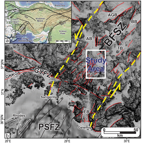
South-western Turkey is a tectonically very active region dominated by Aegean back-arc extension regime (McKenzie, Citation1978; Meulenkamp, Wortel, van Wamel, Spakman, & Strating, Citation1988; Pichon & Angelier, Citation1979; Yilmaz et al., Citation2000), westward motion of Anatolia (Dewey & Şengör, Citation1979; Sengor, Citation1979; Şengör, Görür, & Şaroğlu, Citation1985) and the subduction transform edge propagator (STEP) fault zone (Govers & Wortel, Citation2005; Hall, Aksu, Elitez, Yaltırak, & Çifçi, Citation2014). In the previous studies, the NE–SW striking faults between Burdur and Fethiye in south-western Turkey (Figure ) were named the Burdur Fault, Fethiye-Burdur Fault, Fethiye-Burdur Fault Zone, Burdur-Fethiye Fault Zone or Burdur-Fethiye Shear Zone (e.g. Barka & Reilinger, Citation1997; Barka, Reilinger, Şaroğlu, & Şengör, Citation1995; Bozcu, Yağmurlu, & Şentürk, Citation2007; Elitez & Yaltırak, Citation2014b; Elitez, Yaltırak, Hall, Aksu, & Çifçi, Citation2015; Eyido?an & Barka, Citation1996; Glover & Robertson, Citation1998; Hall et al., Citation2014; Over et al., Citation2010; Över et al., Citation2013; ten Veen, Citation2004; ten Veen, Boulton, & Alçiçek, Citation2009; Verhaert, Similox-Tohon, Vandycke, Sintubin, & Muchez, Citation2006; Verhaert et al., Citation2004; ) after the pioneering work of Dumont, Poisson, and Şahinci (Citation1979). However, recent studies showed that there is a left-lateral trans-tensional zone, which was named the Burdur-Fethiye Shear Zone, between the western Anatolian extensional and the Western Taurides compressional regimes (Elitez & Yaltırak, Citation2016; Elitez, Yaltırak, & Aktuğ, Citation2016)
Figure 1. (a) Simplified tectonic map of the Turkey compiled from Yaltırak İşler, Aksu, and Hiscott (Citation2012). TEF: Thrace-Eskişehir Fault, NAF: North Anatolian Transform Fault, EAFZ: East Anatolian Fault Zone, DSFZ: Dead Sea Fault Zone, IA: Isparta Angle, BFSZ: Burdur-Fethiye Shear Zone. Rectangle indicates Figure 1b. (b) Simplified fault map of the southwestern Turkey and location of the study area. BFSZ: Burdur-Fethiye Shear Zone, PSFZ: Pliny-Strabo Fault Zone, GYFZ: Gökova-Yeşilüzümlü Fault Zone, AB: Acıpayam Basin, AGB: Acıgöl Basin, BB: Burdur Basin, TB: Tefenni Basin, EB: Eşen Basin, GNKG: Gökova-Nisyros-Karpathos Graben.
The so called Kibyra Fault is thought to be located in the middle section of the Burdur-Fethiye Shear Zone, between north-east of Çamköy and İbecik villages (Figure ) and destroyed the ancient city of Kibyra. The existence and activity of Kibyra Fault was suggested first by Akyuz and Altunel (Citation1997, Citation2001). They observed a damage in the stadium of the ancient city and attributed it the activity of a NNE-SSW striking left-lateral fault that collapsed seat rows on the eastern side of the stadium. They proposed that this fault cut and displaced Pliocene deposits on both eastern and western sides of the stadium. Alçiçek, Kazancı, Özkul, and Şen (Citation2004), Alçiçek, Kazancı, and Özkul (Citation2005) and Alçiçek, ten Veen, and Özkul (Citation2006) mapped this fault and extended it to the north-east of Çamköy and south-west of Gölhisar. Karabacak (Citation2011) described Kibyra Fault as a N20°E trending, at least 35-km-long fault between İbecik Village in the south and Çamköy Village in the north based on aerial photo study, geological field evidence and offset features. The author argued that slickensides on fault planes, deflected stream beds and terraces, fault-parallel elongated ridges are the surface evidences for the existence and kinematics of left-lateral Kibyra Fault (Karabacak et al., Citation2013). On the other hand, Elitez and Yaltırak (Citation2014a) argued that there is no fault cutting the ancient stadium of Kibyra and the deformation is the result of the differential deformation of the heterogeneous foundation of the stadium.
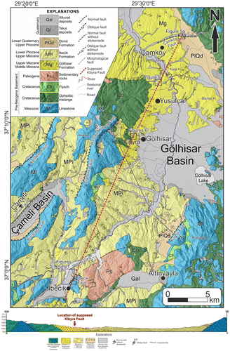
Figure 2. Geological map and X–Y geological cross-section of the study area. The lithological properties and ages of the basement rocks were derived from 1/500000 Denizli sheet geological map of General Directorate of Mineral Research and Exploration (Şenel, Citation2002) and the contacts were redrawn by using DEMs, satellite images and field observations.
The active fault mapping directly affects the settlement suitability, urban planning and economic aspects of engineering structures and their siting. Therefore, in this paper, we focus on the importance of active fault mapping which is very crucial for seismic hazard studies and has the potential to lead scientific and also socio-economic problems. In this context, the main purpose of this study is to verify the existence of supposed Kibyra Fault in the field by integrating geomorphological, paleoseismological (trench excavation), and field observations.
2. Materials and methods
In this study, the geological and geomorphological properties of the region between Çamköy and İbecik (Gölhisar, SW Turkey) and surrounding area are described based on both recent and classical methods. Remote sensing methods that involve use of Digital Elevation Models and satellite and airborne images are effective and efficient ways of revealing geomorphological properties of regions. In this context, we integrated Digital Elevation Model (DEM), DigitalGlobe images provided by Google Earth, available geological maps, and field observations obtained during our field studies between 2008 and 2015. Using all these information and techniques a detailed geological map has been prepared and the trace of supposed Kibyra Fault is also plotted on these geological map (Figure ), based on the information obtained from the publications mentioned above. In order to observe the fault trace, deflected streams and ridge offsets were surveyed and two trenches were excavated in the ancient stadium of Kibyra and Yusufça village. These localities were chosen because the supposed Kibyra crosses over these localities. In addition, the longitudinal river profiles and stream length-gradient (SL) indices (Hack, Citation1973) of individual rivers at different locations were constructed using the GIS software product ESRI ArcGIS Desktop 10.1 (supplementary material).
3. Tectonic framework
The Kibyra Fault is supposed to be located in the Gölhisar basin which is developed within a NE-–SW trending left-lateral shear zone. The pre-Neogene basement of the study area includes Mesozoic limestones, Cretaceous ophiolitic melange and Cretaceous flysch of Lycian Nappes and Paleogene sedimentary rocks which lie unconformably on the Lycian Nappes (Brunn et al., Citation1970; Collins & Robertson, Citation1997, 1998; Ersoy, Citation1990; Önalan, Citation1979). The sedimentary sequence unconformably covers the pre-Neogene basement, begins with Middle-Upper Miocene fluvial conglomerate-sandstone units of the Gölhisar Formation and passes vertically and laterally into the Upper Miocene–Lower Pliocene lacustrine limestone–claystone sequence of the İbecik Formation. The Upper Pliocene–Lower Quaternary alluvial fan conglomerates and mudstones of the Dirmil Formation unconformably overlie these units (Elitez & Yaltırak, Citation2014b; Elitez et al., Citation2015). Recent talus deposits are mainly observed along the front of the fault scarps or high hills and flood plain deposits of the present river network are situated unconformably on top of all the pre-Holocene sequences.
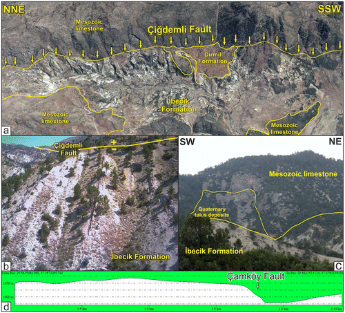
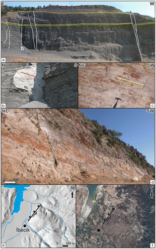
Numerous small-scale to mesoscopic faults can be observed in the region and they are mainly NE-striking normal faults with or without slight left-lateral strike-slip components (Hall et al., Citation2014). In addition to these small-scale faults several major faults also exists in the region. In this regard, we have determine three types of major faults in the region; (1) faults which can be recognised from digital elevation models (DEM) and contain measurable kinematic indicator in the field, (2) faults which can be recognised on the DEM and can also be defined by cross-cutting relationships and offset features, (3) photo-lineaments which are morphologically distinct linear features and can be recognised on DEMs and other satellite or airborne imagery (Figure ). Most of these faults are striking NE–SW and dipping NW directions, SE-dipping faults are also common as well. The Kalınkoz Fault is a NE-–SW striking NW dipping normal fault located to the north of Çameli Basin which is delimited at the north-west by the Çameli Fault and at by the Kızılyaka Fault at the south-east. Both Çameli and Kızılyaka faults are NE-striking left-lateral oblique-slip normal faults. The NNE-striking, WNW-dipping Çiğdemli Fault (Figure (a)) is a normal fault situated at the north-east of Çameli Basin. The Miocene deposits in front of the fault are steeply dipping due west (Figure (b)). Although, no kinematic indicator have been observed on the fault planes, there are other geological evidences which implies that the Çiğdemli Fault might be a normal fault with left lateral strike-slip component. Other normal faults in the study area are Kuşdili Fault, located in the southern part of Gölhisar Basin and Çamköy Fault located in the northern part of the study area (Figure ). The Kuşdili Fault is a NE–SW striking NW dipping fault that occur between pre-Neogene basement units and alluvial fan deposits of Dirmil Formation (Figure ) (Elitez & Yaltırak, Citation2014b). In the northern part of the study area, there is an asymmetric valley. The southern flank of this valley has a steep slope and the attitudes of the exposed Miocene deposits are the same on the both sides of the valley. This morphology indicates a normal fault which we named as Çamköy Fault (Figure (d)). A NE-striking left-lateral oblique-slip normal fault exists at the western boundary of the Gölhisar Basin. Contrary to the other researchers, we have given ‘western Kibyra’ name to this fault (Figure ) because the ancient city of Kibyra is located on the hanging wall. Quaternary talus deposits comprising limestone blocks and boulders are observed in front of the western fault scarp (Figure (c)) indicating present activity of the fault. The İbecik Fault which is located in the southern part of the study area is discussed in the next section.
Figure 3. (a) 3D satellite image of the Çiğdemli Fault. Yellow arrows indicate the fault trace. (b) Claystones and limestones of İbecik Formation with high angles. (c) Quaternary talus deposits in front of the Kibyra Fault which was located to north-west of Kibyra. (d) S–-N topographic profile of the location where Çamköy Fault exists.
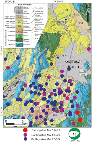
The largest known earthquakes in the Gölhisar Basin are AD 23 and 417 earthquakes that damaged the Kibyra (Guidoboni, Comastri, & Traina, Citation1994). The largest recorded earthquakes (Mw 5.0 and Mw 5.5) occurred in 1990 (USGS earthquake catalogue, Citation2015). The earthquakes are commonly occurred at the southern part of the Gölhisar Basin (Figure ). Considering the presence of widespread alluvial fan deposits of the Dirmil Formation in front of the Çiğdemli and Kuşdili faults, talus deposits in front of the Kibyra Fault and current seismicity in the region, it can be claimed that at least one of these three faults must be responsible from the earthquake tremors and destruction of ancient city of Kibyra.
Figure 4. Seismotectonic map of the study area. Earthquake data from USGS (Citation2015).
4. Faults in the study area
It was suggested that the Kibyra Fault is a 35-km-long fault, located between north-east of Çamköy village, cuts the ancient stadium of Kibyra and extends to the İbecik village in the south-west (Akyuz & Altunel, Citation1997, Citation2001; Alçiçek et al., Citation2006; Karabacak, Citation2011). At the northern tip of the supposed Kibyra Fault, several N–S trending strike-slip faults can be observed (Figure (a)). According to Alçiçek et al. (Citation2006), these faults are Quaternary dextral strike-slip faults that cut the tilted Pliocene conglomerates and extend into the ancient stadium of Kibyra. Karabacak (Citation2011) argued that these vertical faults cut the Quaternary deposits and the horizontal motion is consistent with the motion of the fault in the İbecik village.
Figure 5. (a) Miocene conglomerates and strike-slip faults. Yellow lines indicate the layers. (b) indicates the location of Figure b. (b) Fault plane of the strike-slip fault shown in Figure (a). Red line indicates the striation. (c) Fault plane of the İbecik Fault shown in Figure (d). Yellow line indicates the striation. (d) View of the İbecik Fault in the field. (e) View of the İbecik Fault on DEM. (f) View of the İbecik Fault on satellite image.
Our field study observations conflict with these studies. In the north-east, the ~30 m thick conglomeratic sequence which is composed of the middle-upper Miocene Gölhisar Formation includes several N–S and NNE–SSW trending pure strike-slip faults (Figure (b)). These faults don’t cut the whole sequence, the upper ~5 m thick sediments cover all these strike-slip faults (Figure (a)). Therefore, these faults can neither be Quaternary faults nor a part of the supposed Kibyra Fault.
Furthermore, when examining the fault in İbecik village, it represents a different character from the north-eastern faults. This fault, which we named as İbecik Fault (Figure (d)), is a 1-km-long, N38°E/58°NW left-lateral oblique normal fault with slickenside pitches around 15° and observed between the lacustrine claystones of İbecik Formation and Mesozoic limestones of Lycian Nappes (Elitez & Yaltırak, Citation2014b; Elitez et al., Citation2015). The alignment of the trace of fault is obviously expressed on DEMs and satellite images (Figure (e) and (f)). It does not extend no further than few hundred meters to north-east or south-west, therefore, it cannot be the continuation of the supposed İbecik Fault.
4.1. The ancient city of Kibyra
For the existence and current activity of the Kibyra Fault is claimed to be the collapsed seat rows in the stadium of Kibyra. Kibyra, especially the ancient stadium, display abundant architectural relics and collapsed features most probably due to the earthquakes in 23 and 417 Guidoboni et al. (Citation1994). The first geo-archaeological studies in the ruins were undertaken by Akyüz and Altunel (1997). They suggested up to 50 cm sinistral offset along the seat rows of the Kibyra stadium and claimed that the Kibyra Fault is a N15E striking fault. Alçiçek et al. (Citation2006) argued that there are vertical offsets reaching up to 50 cm. Karabacak (Citation2011) and Karabacak et al. (Citation2013) attributed the structural deformation on the constructions of Kibyra to a left-lateral fault passing through stadium. They used the asymmetric damage on the seat rows as the evidence for the left-lateral offset along the fault. Elitez and Yaltırak (Citation2014a) argued that there is no displacement on the lowermost seat row and the ground below them. Likewise, on the eastern wall of the stadium along the course of the supposed Kibyra Fault no displacement occurred. Based on this information Elitez and Yaltırak (Citation2014a) proposed that the damage was most likely caused by weak artificial foundation fill rather than any fault crossing the ancient city.
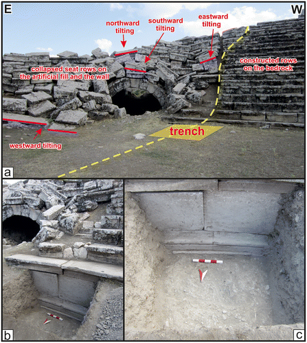
The stadium of Kibyra is located on a N–S elongated, west facing concave ridge (Figure (a)). The topography shows that the western side of this ridge was most probably excavated before the construction of the stadium (Figure (b)). Two types of artificial fill materials were derived from this part of the ridge. One of them is a poorly cemented partly consolidated material. This material was spread in the eastern side of the ridge in order to form a platform for the eastern seat rows and today it is clearly apparent on the eastern slope of the stadium (Figure (c)). The other type of material comprise conglomeratic blocks (Figure (d)) which are used for the construction of the eastern wall on which the eastern seat rows were placed (Özüdoğru, Dökü, Dikbaş, & Vanhavarbeke, Citation2011). On the southern side of the stadium, there are 20 seat rows and the lowermost row is half-buried. It is important counter evidence that the supposed Kibyra Fault crosses the southern seat rows, however, no displacement occurred on this lowermost row (Figure ). In order to verify this observation, a 1.3 m deep trench was excavated in front of the half-buried row by the help of the responsible archaeologists (Figure ; Elitez & Yaltırak, Citation2014a). The trench revealed that the stadium floor is covered by approximately 1.3 m thick fill material and there is no displacement on the lowermost row or deeper levels, therefore, no fault exists along the collapsed seat rows contrary to Akyüz and Altunel (Citation1997), Karabacak (Citation2011) and Karabacak et al. (Citation2013).
Figure 6. (a) Aerial photo of the ancient stadium of Kibyra. Yellow dashed line indicates the artificial fill area. Red dashed line indicates the excavated area. c and d indicate the locations of Figure (c) and (d). (b) E–W cross-section of the southern part of the ancient stadium. (c) Boundary between bedrock and artificial fill. (d) Conglomerate blocks used during the construction of the eastern seat rows.
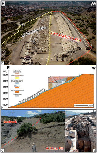
Figure 7. (a) Trench excavated in front of the southern seat rows. Yellow dashed line indicates the supposed Kibyra Fault. (b) and (c) show the lowermost row and bottom of the stadium from different directions. Scale in the trench is 50 cm.
4.2. Paleoseismologic study
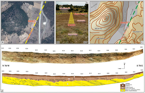
Another trench was excavated by the General Directorate of Mineral Research and Exploration (MTA) for paleoseismic investigation. The trench site is located north of Yusufça (Figures and ) and also close to river pattern change in front of Kara Hill, and deflected stream channels and a ridge in the eastern side of Yusufça which are supposed to indicate the activity of the Kibyra Fault (Karabacak, Citation2011) (see locations 2 and 3 in supplementary material). The trench was excavated in an ancient stream bed and extended up to slopes of a small hill out of the stream bed (Figure (a)–(c)). The ~32-m-long, ~2-m-deep trench exposes three different deposits. These include pre-Neogene basement rocks, channel-swamp deposits and soil cover. At the base of the trench, mainly south-east dipping conglomerates and sandstones alternating with clay beds (Figure (d)) are exposed. The pebbles were derived from the ophiolitic sequences and limestones of the pre-Neogene basement. These sediments are overlain by (probably) Holocene channel-swamp deposits and followed by ~50 cm thick soil cover. No trace of fault was observed in the trench (Figure (d)).
Figure 8. (a) Satellite image of the trench site. Yellow dashed line indicates supposed Kibyra Fault. (b) Trench direction and geological units in the trench site. Yellow dashed line indicates supposed Kibyra Fault. (c) Simplified geological map and digital elevation model of the trench site. Green dashed line indicates supposed Kibyra Fault. (d) Northern wall of the trench (Coordinate: 37°13′11.45″N 29°31′55.35″E).
5. Discussion
In this study, we evaluated the existence of the Kibyra Fault by integrating remotely sensed data, field observations and paleoseismological trench excavations.
The south-western Turkey is a tectonically very active region and contains numerous seismically active faults. The alignments of these faults are markedly expressed on the DEMs, satellite and airborne imagery. Most of these faults are exposed in the field which provides ample evidence for determining their characteristics and kinematics. The most cited paper about the tectonic framework of the SW Turkey includes Barka et al. (Citation1995) which proposed the concept of Fethiye-Burdur Fault Zone (FBFZ) that inspired the proponents of FBFZ such as Akyuz and Altunel (Citation2001) who considered the Kibyra Fault as one of the segments of this fault zone. Later, Alçiçek et al. (Citation2006), Karabacak (Citation2011) and Karabacak et al. (Citation2013) adopted the same concept for the supposed Kibyra Fault. However, there is no single evidence for the existence of such a NE–SW-trending left-lateral fault zone which could be a part of a large shear zone, the so called Fethiye-Burdur Fault Zone with normal- and strike-slip components (Elitez et al., Citation2015; Hall et al., Citation2014).
It is customary that in order to examine the existence and characteristics of a fault, a number of geological and geomorphological evidences are required. Therefore, the NW–SE topographic profiles were constructed and also the SL indices and lithologies have been superimposed onto the river longitudinal profiles (supplementary material). Based on the SL indices linked to relative rock resistance, several rivers have anomalously high SL index values on relatively soft rocks of İbecik and Gölhisar formations. These high indices are most probably associated with the faults, folding and/or contacts between different rock units. The anomalies along supposed Kibyra Fault are observed in a few locations. However, these high indices cannot be interpreted as tectonic signals. These anomalies are mostly related to the faults in the geological units.
Apart from geological data geomorphological evidences are very crucial for the recent activities of faults. High resolution satellite images and digital elevation models provide invaluable information for detection and delineation of active faults in a region. In addition to these data, paleo- and archeo-seismological data are prime importance for determining the late Quaternary to recent activities of faults and their earthquake recurrence intervals. In this study, we have used all these methodologies in order to verify the existence and recent activity of the Kibyra Fault. However, we could not encounter single convincing evidence along the trace of supposed Kibyra fault from İbecik village in the south to Çamköy in the north (Figure ) which is the proposed trace of the fault (Akyuz & Altunel, Citation1997, Citation2001; Alçiçek et al., Citation2004, Citation2005, Citation2006; Karabacak, Citation2011; Karabacak et al., Citation2013). Based on these data we came to a conclusion that there is no Kibyra Fault at least at the location firstly proposed by Akyüz and Altunel (Citation1997).
It is important to note here that, apart from their scientific importance, presence of active faults in a region has important socio-economic consequences in terms of site selection of engineering structures and settlements. Nowadays many lineaments, which are characterised as active faults, are asserted in the geological studies and take part in literature. Unfortunately, some of these faults are derived from incorrect interpretation or unsupported data (e.g. ten Veen et al., Citation2009; also see Elitez et al., Citation2015). The supposed Kibyra Fault is one of the examples of such faults.
6. Conclusions
| • | The faults which are located in the north-eastern and south-western parts of the study area are parallel to each other but have pure left-lateral and normal fault with left-lateral strike-slip components, respectively. Therefore, kinematically it is almost impossible that they cannot be parts of a single continuous fault. | ||||
| • | No cross-cutting and offset relationships that could indicate the presence of supposed Kibyra Fault is observed neither in the trenches located in the stadium of Kibyra and nor along the proposed trace of the fault around Yusufça village. | ||||
| • | The detailed geomorphological observations show that there is no linear feature that might indicate a 35-km-long fault. | ||||
| • | There are no appreciable stream deflections nor ridge offsets along the supposed fault trace to indicate a single trace of a left-lateral fault. | ||||
| • | The supposed Kibyra Fault does not exist. | ||||
Disclosure statement
No potential conflict of interest was reported by the authors.
Supplemental data
The supplemental material for this paper is available at http://dx.doi.org/10.1080/09853111.2017.1318001.
Funding
The authors are grateful to İstanbul Technical University Scientific Research Projects Coordination Department [Project number 32511] for their financial support for the field studies.
TGDA_1318001_Supplementary_material.pdf
Download PDF (3.5 MB)Acknowledgements
This study is part of the ongoing Ph.D. studies of Elitez at İstanbul Technical University. We thank to Şükrü Özüdoğru and F. Eray Dökü (Directors of the excavation team of the ancient city of Kibyra) for providing the opportunity to excavate a research trench and Tamer Duman from General Directorate of Mineral Research and Exploration (MTA) for the trench data. We thank the archaeologists Düzgün Tarkan, Mesut Kaya and Mustafa Şimşek for their help. Nuretdin Kaymakcı improved the English of the manuscript. We also thank the reviewers and editor for helpful contributions to the manuscript.
Related Research Data
References
- Akyuz, H. S., & Altunel, E. (1997). 417 Cibyra Depremi: Burdur-Fethiye Fay Zonu’nun Sol-Yanal Hareketine ait Veriler (GB Anadolu) [417 Cibyra Earthquake: Data on the left-lateral movement of the Burdur-Fethiye Fault Zone (SW Anatolia)]. Paper presented at the Aktif Tektonik Araştırma Grubu Birinci Toplantısı, İTÜ, İstanbul.
- Akyuz, H. S., & Altunel, E. (2001). Geological and archaeological evidence for post-Roman earthquake surface faulting at Cibyra, SW Turkey. Geodinamica Acta, 14, 95–101.
- Alçiçek, M. C., Kazancı, N., & Özkul, M. (2005). Multiple rifting pulses and sedimentation pattern in the Çameli Basin, southwestern Anatolia, Turkey. Sedimentary Geology, 173, 409–431.
- Alçiçek, M. C., Kazancı, N., Özkul, M., & Şen, Ş. (2004). Çameli (Denizli) Neojen Havzasının Tortul Dolgusu ve Jeolojik Evrimi [Washable (Denizli) Neogene water basin sedimentation filler and geological evolution]. MTA Dergisi, 128, 99–123.
- Alçiçek, M. C., ten Veen, J. H., & Özkul, M. (2006). Neotectonic development of the Çameli Basin, southwestern Anatolia, Turkey. Geological Society, London, Special Publications, 260, 591–611.
- Barka, A., & Reilinger, R. (1997). Active tectonics of the Eastern Mediterranean region: Deduced from GPS, neotectonic and seismicity data. Annals of Geophysics, 40, 587–610.
- Barka, A., Reilinger, R., Şaroğlu, F., & Şengör, A. M. C. (1995). The Isparta Angle: Its importance in the neotectonics of the eastern Mediterranean region. Paper presented at the International Earth Sciences Colloquium on the Aegean Region, 9–14 October 1995, Güllük, İzmir, Turkey.
- Bozcu, M., Yağmurlu, F., & Şentürk, M. (2007). Some Neotectonic and Paleosismological features of the Fethiye-Burdur Fault zone, SW Anatolia. Geological Engineering, 31, 25–48.
- Brunn, J. H., Graciansky, P. C., Gutnic, M., Juteau, T., Lefevre, R., Marcoux, J., … Poisson, A. (1970). Structures majeures et correlations stratigraphiques dans les Taurides occidentales [Major structures and stratigraphic correlations in Western Taurides]. Bulletin de la Societe Geologique de France, 3, 515–556.10.2113/gssgfbull.S7-XII.3.515
- Collins, A. S., & Robertson, A. H. F. (1997). Lycian melange, southwestern Turkey: An emplaced Late Cretaceous accretionary complex. Geology, 25, 255–258.10.1130/0091-7613(1997)025<0255:LMSTAE>2.3.CO;2
- Collins, A. S., & Robertson, A. H. F. (1998). Processes of Late Cretaceous to Late Miocene episodic thrust-sheet translation in the Lycian Taurides, SW Turkey. Journal of the Geological Society, 155, 759–772.10.1144/gsjgs.155.5.0759
- Dewey, J. F., & Şengör, A. M. C. (1979). Aegean and surrounding regions: Complex multiplate and continuum tectonics in a convergent zone. Geological Society of America Bulletin, 90, 84–92.10.1130/0016-7606(1979)90<84:AASRCM>2.0.CO;2
- Dumont, F. J., Poisson, A., & Şahinci, A. (1979). Sur l’existence de coulissement sénestres récent a l’extrémité orientale de l’arc Égéen (sud-ouest de la Turquie) [On the existence of recent senescent slide at the eastern end of the Aegean arch (southwestern Turkey)]. Comptes Rendus de l’Académie des Sciences, 289, 261–264.
- Elitez, İ., & Yaltırak, C. (2014a). Comment on Analyses of Seismic Deformation at the Kibyra Roman Stadium, Southwest Turkey by Volkan Karabacak, Önder Yönlü, Eray Dökü, Nafiye Günenç Kıyak, Erhan Altunel, Şükrü Özüdoğru, Cahit Çağlar Yalçıner, and Hüsnü Serdar Akyüz. Geoarchaeology, 29, 349–352.10.1002/gea.2014.29.issue-4
- Elitez, İ., & Yaltırak, C. (2014b). Miocene-Quaternary Geodynamics of Çameli Basin Burdur-Fethiye Shear Zone (SW Turkey). Geological Bulletin of Turkey, 57, 41–67.
- Elitez, I., Yaltırak, C., Hall, J., Aksu, A. E., & Çifçi, G. (2015). Reply to the comment by M.C. Alçiçek on ‘The Fethiye–Burdur Fault Zone: A component of upper plate extension of the subduction transform edge propagator fault linking Hellenic and Cyprus Arcs, Eastern Mediterranean,’ Tectonophysics, 635, 80–99, by J. Hall, A.E. Aksu, İ. Elitez, C. Yaltirak and G. Çifçi. Tectonophysics, 664, 5–13.10.1016/j.tecto.2015.04.002
- Elitez, İ., Yaltırak, C., & Aktuğ, B. (2016). Extensional and compressional regime driven left-lateral shear in southwestern Anatolia (eastern Mediterranean): The Burdur-Fethiye Shear Zone. Tectonophysics, 688, 26–35.10.1016/j.tecto.2016.09.024
- Elitez, İ., & Yaltırak, C. (2016). Miocene to Quaternary tectonostratigraphic evolution of the middle section of the Burdur-Fethiye Shear Zone, south-western Turkey: Implications for the wide inter-plate shear zones. Tectonophysics, 690, 336–354.10.1016/j.tecto.2016.10.003
- Ersoy, Ş. (1990). The analysis of evolution and structural items of the western Taurus-Lycian Nappes. Geological Engineering (Bulletin Chamber of Geological Engineer, Turkey), 37, 5–16.
- Eyido?an, H., & Barka, A. (1996). The 1 October 1995 Dinar earthquake, SW Turkey. Terra Nova, 8, 479–485.10.1111/ter.1996.8.issue-5
- Glover, C., & Robertson, A. (1998). Neotectonic intersection of the Aegean and Cyprus tectonic arcs: Extensional and strike-slip faulting in the Isparta Angle, SW Turkey. Tectonophysics, 298, 103–132. doi:10.1016/S0040-1951(98)00180-2
- Govers, R., & Wortel, M. J. R. (2005). Lithosphere tearing at STEP faults: Response to edges of subduction zones. Earth and Planetary Science Letters, 236, 505–523.10.1016/j.epsl.2005.03.022
- Guidoboni, E., Comastri, A., & Traina, G. (1994). Catalogue of ancient earthquakes in the Mediterranean area up to the 10th century. Rome: Istituto Nazionale di Geofisica.
- Hack, J. T. (1973). Stream-profiles analysis and stream-gradient index. Journal of Research of the US Geological Survey, 1, 421–429.
- Hall, J., Aksu, A. E., Elitez, I., Yaltırak, C., & Çifçi, G. (2014). The Fethiye-Burdur fault zone: A component of upper plate extension of the subduction transform edge propagator fault linking Hellenic and Cyprus Arcs, Eastern Mediterranean. Tectonophysics, 635, 80–99.10.1016/j.tecto.2014.05.002
- Karabacak, V. (2011). Geological, geomorphological and archaeoseismological observations along the Cibyra Fault and their implications for the regional tectonics of SW Turkey. Turkish Journal of Earth Sciences, 20, 429–447. doi:10.3906/Yer-0911-51
- Karabacak, V., Yönlü, Önder, Dökü, E., Kıyak, N. G., Altunel, E., Özüdoğru, S., … Akyüz, H. S. (2013). Analyses of seismic deformation at the Kibyra Roman stadium, Southwest Turkey. Geoarchaeology, 28, 531–543.10.1002/gea.2013.28.issue-6
- Pichon, X., & Angelier, J. (1979). The hellenic arc and trench system: A key to the neotectonic evolution of the eastern mediterranean area. Tectonophysics, 60, 1–42.10.1016/0040-1951(79)90131-8
- McKenzie, D. (1978). Active tectonics of Alpine–Himalayan belt – Aegean Sea and surrounding regions. Geophysical Journal International, 55, 217–254.10.1111/j.1365-246X.1978.tb04759.x
- Meulenkamp, J. E., Wortel, M. J. R., van Wamel, W. A., Spakman, W., & Strating, E. H. (1988). On the Hellenic subduction zone and the geodynamic evolution of Crete since the late Middle Miocene. Tectonophysics, 146, 203–215.10.1016/0040-1951(88)90091-1
- Önalan, M. (1979). Elmalı-Kaş (Antalya) arasındaki bölgenin jeolojisi [The geology of the region between Elmalı-Kaş (Antalya)]. (Unpublished PhD thesis). İstanbul Üniversitesi.
- Over, S., Pinar, A., Ozden, S., Yilmaz, H., Unlugenc, U. C., & Kamaci, Z. (2010). Late cenozoic stress field in the Cameli Basin, SW Turkey. Tectonophysics, 492, 60–72. doi:10.1016/j.tecto.2010.04.037
- Över, S., Yılmaz, H., Pınar, A., Özden, S., Ünlügenç, U. C., & Kamacı, Z. (2013). Plio-Quaternary Stress State in the Burdur Basin, SW-Turkey. Tectonophysics, 588, 56–68. doi:10.1016/j.tecto.2012.12.009
- Özüdoğru, Ş., Dökü, F. E., Dikbaş, G., & Vanhavarbeke, H. (2011). Kibyra 2010. ANMED, 9, 36–43.
- Sengor, A. M. C. (1979). The North Anatolian transform fault: Its age, offset and tectonic significance. Journal of the Geological Society, 136, 269–282.10.1144/gsjgs.136.3.0269
- Şengör, A. M. C., Görür, N., & Şaroğlu, F. (1985). Strike-slip deformation, basin formation and sedimentation: Strike-slip faulting and related basin formation in zones of tectonic escape: Turkey as a case study. Society of Economic Paleontologists and Mineralogist, 37, 227–264.
- Şenel, M., 2002. Geological map of Turkey, Denizli 1:500.000 scale sheet. Ankara, Turkey: General Directorate of Mineral Research and Exploration.
- ten Veen, J. H. (2004). Extension of Hellenic forearc shear zones in SW Turkey: The Pliocene–Quaternary deformation of the Eşen Çay Basin. Journal of Geodynamics, 37, 181–204. doi:10.1016/j.jog.2004.02.001
- ten Veen, J. H., Boulton, S. J., & Alçiçek, M. C. (2009). From palaeotectonics to neotectonics in the Neotethys realm: The importance of kinematic decoupling and inherited structural grain in SW Anatolia (Turkey). Tectonophysics, 473, 261–281. doi:10.1016/j.tecto.2008.09.030
- USGS. (2015). Earthquake archive search & URL builder. Retrieved from http://earthquake.usgs.gov/earthquakes/search/
- Verhaert, G., Muchez, P., Sintubin, M., Similox-Tohon, D., Vandycke, S., Keppens, E., … Richards, D. A. (2004). Origin of palaeofluids in a normal fault setting in the Aegean region. Geofluids, 4, 300–314.10.1111/gfl.2004.4.issue-4
- Verhaert, G., Similox-Tohon, D., Vandycke, S., Sintubin, M., & Muchez, P. (2006). Different stress states in the Burdur-Isparta region (SW Turkey) since Late Miocene times: A reflection of a transient stress regime. Journal of Structural Geology, 28, 1067–1083.10.1016/j.jsg.2006.03.013
- Yaltırak, C., İşler, E. B., Aksu, A. E., & Hiscott, R. N. (2012). Evolution of the Bababurnu Basin and shelf of the Biga Peninsula: western extension of the middle strand of the North Anatolian Fault Zone, Northeast Aegean Sea, Turkey. Journal of Asian Earth Sciences, 57, 103–119.
- Yilmaz, Y., Genç, Ş. C., Gürer, F., Bozcu, M., Yilmaz, K., Karacik, Z., … Elmas, A. (2000). When did the western Anatolian Grabens begin to develop? Geological Society, 173, 353–384.10.1144/GSL.SP.2000.173.01.17