Abstract
The progressive transition from digital to smart cities has become a reality in recent years. Studies on the fundamental concept of smart cities,along with their supporting techniques,have attracted unprecedented attention. This paper first discusses the concept ofsmart cities, where it is pointed out that the real city and the digital city can be integrated into a smart city by using ubiquitous sensor networks or the Internet of Things. More intelligent services for city management and public services can be provided in smart cities through massive and complex calculation,analysis, and data mining on cloud computing platforms.A smart city’s representative characteristics are summarized here to demonstrate that smart cities are superior for offering technical securities and intelligent services. Smart municipal supervision, smart transportation, smart environment monitoring, and smart tourism are used as examples to support the discussion.
1. Introduction
Smart cities can be identified along six main axes of dimensions: a smart economy, a smart environment, smart mobility, smart people, smart living, and smart governance (http://en.wikipedia.org/wiki/Smart_city; Citation[1]). There are views on the concept of a smart city as diverse as the authors’ fields of expertise. Tranosand Gertner Citation[2] portrayed a smart city as a combination of sensor networks. Shapiro Citation[3]referredto a smart city as an improvement of social operation quality.As an IT service provider, Dignan Citation[4] of Microsoft Corporation considered a smart city as a smart and human-friendly service. Harrison et al. Citation[5] of IBM, from a system integrator’s perspective, regarded a smart city as a wider interconnection. Usually, a smart city rests on three pillars: economic development, Earth environmental issues, and social equity; and sustainability can be achieved only if all three aspects are equally considered.From the perspective of geomatics, a smart city is the full integration of a digital city, the Internet of Things, and cloud computing technology. A digital city provides a 3D geospatial framework for cities, while the Internet of Things embedded in the ubiquitous sensor network (USN) realizes the real-time sensing, measuring, and data transmitting of still or moving objects. Cloud computing, performing like a human brain, is responsible for massive and complex calculations, data mining, and analysis; andit then helps in the automatic discovery of patterns, rules, and knowledge and provides remote monitoring, control, and feedback to the real world for intelligent city management and public services.
Most of the current smart city efforts are focused on how to build a complete Internet of Things, including men, machines, and city infrastructure through a variety of wireless sensor networks, as well as how to accomplish real-time analysis and control by super-computers on cloud computing platforms. However, smart cities also refer to a smart mechanism for city management and operation, which holds several characteristics involving sensing, measurement, perception, analysis, visualization, and self-controlling. Digital cities reside in cyber space, whereas smart cities belong to cyber physical space. In a smart city, citizens have better and safer living conditions, including, but not limited to, such as pects as power supply, transportation, medical care, education, urban management, and emergency response.
There is a demand for and a real shift from digital cities to smart cities. Motivated by this observation, we will describe the key supporting technologies of smart cities (i.e., digital cities, Internet of Things, and cloud computing).From the geomatics perspective, the fundamental and operational issues for a smart cityare addressed, including geo-referencing and 3D spatial-temporal modelling, integration of GPS, remote sensing and GIS in mobile platforms, devices and structures for ubiquitous sensing and communication, and service capabilities in cloud environments. The following topics also are discussed later as suggestions for future investigation:the technical difficulties with and challenges for location clouds and remote sensing clouds, the integration of video and sensing platforms with GIS, and the capabilities and potential for utilizing smart phones in indoor navigation and ubiquitous sensing. To support the discussion, we will present examples of smart city implementations, including smart municipal supervision, smart transportation, smart environment monitoring, and smart tourism.
The rest of the paper is structured as follows. Following the concept and background of smart cities in this section, Section 2 discusses the three key supporting techniques for smart cities. Five characteristics of smart cities then are summarized in Section 3. Section 4 highlights seven newtopics being investigated in current and future smart city development, and Section 5 demonstrates four examples of recent smart city-related projects. The paper concludes with a discussion of possible future developments in Section 6.
2 Supporting techniques of Smart Cities
2.1 Digital Cities
Digital cities evolved from the concept of digital Earth. AlGore Citation[6], a former vice president of the U.S.,definedthe digital visual Earth scene as having the purpose of providing appropriate service patterns integrated with the Internet.This concept offers a new perception about the functionalities of digital cities and has been widely employed in urban infrastructure upgrading programs by the U.S. federal and local governments.As the most important part of digital Earth, digital cities have attracted a great deal of scientific study,followed by many nationwide digitalization projects Citation[7]. In general, a digital city is a seamless framework containing all kinds of information to ensure the city operates smoothly and orderly. It aims to organize all of the diverse information distributed in different local offices viaa unified coordinated system, inwhich both natural and social correlations can be visualized and the information retrieval services implemented according to human recognition patterns. Furthermore, a digital city, as a significant copy of our real world, contains all the natural, social, and economic information related to the physical real city. Particularly, it consists of 2D digital maps, 3D digital city models, 4D spatial-temporal databases, and points of interests Citation[8].From a geomatics point of view, the supporting techniques of a digital city consist of the following.
| 1. | Space, air,and land-based sensor websfor geospatial data acquisition and updating plus modern communication devices; | ||||
| 2. | Building extraction and 3D/4Dmodelling; | ||||
| 3. | Multi-resolution, multi-scale,and multi-dimensional visualizations of geospatial data; | ||||
| 4. | Distributed spatial data archiving and management for federal databases with interoperability; | ||||
| 5. | Spatial data analysis and mining techniques; and | ||||
| 6. | GNSS and location-based service techniques. | ||||
Although these technologies are becoming mature and stable, the future generation of digital cities still requires the complete cooperation of various governments and institutions, the standardization of data and products, and the interoperability of non-profit organizations and cooperation Citation[9]. The ultimate goal of a digital city, with the help of all the above technologies, is to provide the “right data” to the right person at a right time and a right place Citation[10].
2.2 Internet of Things
The “Internet of Things”concept emerged in 1999. It refers to uniquely identifiable objects (things) and their virtual representations in an Internet-like structure. In 2005, the International Telecommunication Union issued the ITU Internet Report 2005: Internet of Things, which,for the first time, provided a comprehensive description of the Internet of Things Citation[11].Generally, the Internet of Things can be defined as follows: adopting Radio Frequency IDentification (RFID), infrared sensors, GPS, and information sensing devices (e.g., cameras and scanners) connecting any items or things that can be connected via the Internet based on agreed protocols of information exchange and communication. Such connections can be used for intelligent identification, localization, tracking, monitoring, and management of things.Specifically, the Internet of Things is built by inter-connected diverse types of sensors inserted or equipped in electric networks, rail networks, bridges, tunnels, roads, structures, water supply systems, dams, gas pipelines, etc. China proposed its agenda on creating the Internet of Things in 1999 and then the Chinese Academy of Sciences commenced related studies on sensor networks. With China’s policy on integration of the manufacturing industry and the information industry,the Internet of Things was considered a major breakthrough since its goal lies in the full interaction of machines and human beings Citation[12].
The Wireless World Research Forum (WWRF) forecasted in 2006 that there will be seven trillion sensors in operation to provide services for over seven billion people on Earth by 2017 Citation[13]. On average,the number of sensors applied in personal services will be about 1,000 per person,which means that fresh and real-time updated information will be obtained and shared by different kinds of sensors directly instead of relying on historical data stored on the Internet. At present, smart phone, vehicular GPS, and digital housing sensors are used.A person carrying some type of sensor can be regarded as a data collector and further as a mobile agent in the Internet of Things. The birth of the Internet of Things solves the dilemma that the physical collection instruments and the IT infrastructures are isolated from each other. Conventionally, construction and management patterns are separated as a result of the gap between physical instruments and IT infrastructures. The former only focuses on the engineering of buildings(e.g., airports, roads, railways, public architecture, etc.),whereas the latter concentrates on data centers, PCs, broadband networks, etc. Just like water, electricity, gas,and roads, the Internet of Things will become a new kind of infrastructure resource. The main framework of a smart city based on the Internet of Things is shown in Figure .
Figure 1. A framework of the smart city based on the Internet of Things
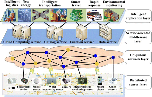
The Internet of Things shown in Figure has a hierarchical structure of four layers:
| 1. | The distributed sensor layer includes various sensors for collecting real-time environmental and social data. Such sensors may include, for example, RFID, fingerprint readers, smoke sensors, water monitoring sensors, video cameras, and smart phones. This layer is designed based on a unified coding system that allocates addresses via distributing unique code to attribute information of certain objects. | ||||
| 2. | The ubiquitous network layer could transfer data and control information between the distributed sensor layer and the service-oriented middleware layer. It consists of all wire and wireless networks including the Internet, Wireless Local Area Networks (WLAN), 3G(3rd-Generation), Long Term Evolution (LTE), and other communication networks. | ||||
| 3. | The service-oriented middleware layer takes charge of intelligent processing and analysis based on cloud computing, data mining, and highly efficient index services, etc. from a huge amount of data collected in real-time by the distributed sensor layer. The results can be used to support decision-making and effective operation of smart city applications. | ||||
| 4. | The intelligent application layer applies tailored intelligence services to different industries andprovides a complete platform for all kinds of users to perceive and handle objects. Based on the comprehensive data, the information and decision-support service, etc., this layer selects the most efficient cloud for a given task. | ||||
2.3 Cloud computing
Cloud computing is based on the Internet and is an extended concept beyond distributed and grid computing that has evolved with resource configuration on the Internet.Interactive computing service has been highly reliant on the advancement of hardware until the emergence of virtual cloud computing, where hardware maintenance is no longer a concern Citation[14]. Through software re-use and flexible combining, cloud computing makes information services intensive, professional,and infinitely sharable. Service efficiency is assured by the optimal organization of the service flow. Since service-oriented computing can be implemented through software assembly, information sharing, and cooperative operation, cloud computing can process massive amounts of global data quickly and provide services for a large user community Citation[14].
In addition, cloud computing allows for a more user-friendly, rapid, and individualized interactive service. Users of cloud computing do not need to be aware of the operation systems, databases, software platforms, hardware, locations of computing centers, software providers, and service approaches.For geospatial information processing, all kinds of complicated analysis,algorithmprocessing, and related experiences are fully shared on cloud computing platforms. All of them will playa role in potential computing capacities and increasing the user’s ability to solve complicated problems in geospatial information analysis and processing. As shown in Figure , the hierarchical structure of cloud computing generally includes four levels: hardware, infrastructure, platform, and application. Service modes of SaaS, PaaS, and IaaS can be provided to build diverse applications based on all four levels Citation[15].
Figure 2. A framework of cloud computing Citation[15]
![Figure 2. A framework of cloud computing Citation[15]](/cms/asset/dacb5a9f-7ee3-4136-944b-4abd15f62517/tgsi_a_772803_o_f0002g.jpg)
A typical example of geospatial cloud computing, OpenRS2Cloud Citation[16]was developed by the State Key Laboratory of Information Engineering in Surveying, Mapping, and Remote Sensing of Wuhan University in China. It was designed under an open and scalable framework, ensuring that both the data resources and the computing resources can be monitored and distributed dynamically to a certain task in the network. Specifically, as a basic remote sensing image processing framework with portable, scalable, configurable, and customizable features, OpenRS2Cloud supports image browsing, processing, and analysis, as well as sensor models and geographic coordinate system management. Data providers and algorithm developers may share their resources at http://www.openrs.org/wiki/. Without special requirements on the computation environment, a user can process the data and receive the expected outcome by only choosing the appropriate data and algorithms.
3 Characteristics of Smart Cities
3.1 Smart cities are based on the fundamental framework of digital cities
An urban spatial data infrastructure is the fundamentalrame work of digital cities Citation[17]. Based on thatframe work, all kinds of information in a digital city can be modeled and indexed; and together with the internal association and relations of natural, human, and societal information, it forms the basis of a smart city.A smart city should also have the capabilities of sensing, control, and analysis.
3.2 Smart cities consist of the Internet of Things and cloud computing
The construction of a smart city emphasizes real-time information gathering, processing, analyzing,and controlling. Similar to a metabolism indicated by the future city concept (Future Cities Laboratory, www.futurecities.ethz.ch, Citation[18], human beings use their bodies(e.g.,touching and vision)to collect information, their brains to process complex information, and their limbs to execute orders issued by the brain. The Internet of Things and cloud computing, in a similar way, are essential forreal-time data collection, analysis, and control in a smart city. They are based on the Internet, however, with extensible capabilities to connect to anything and among things, support their information exchange and communication, and achieve flexible processing and analysis. The Internet of Things and cloud computing in smart cities havefour major aspects, which are shown in Figure .
| 1. | Smart sensor network. This network can acquire information about and the status of objects at any time through sensing equipment (e.g., RFID, 2D encoder, etc.). | ||||
| 2. | Smart security network. This network applies to various kinds of measures to ensure secure transmission of information about and the status of objects among the Internet, broadcast networks, communication networks, digital cluster networks, etc. | ||||
| 3. | Smart cloud processing. Massive amounts of client data and information can be processed and analyzed to support real-time decision-making. | ||||
| 4. | Smart control network. This network is used to provide automatic and intelligent real-time control of objects for better urban services after the acquired data are processed at cloud terminals. | ||||
3.3 Application-and service-orientation
The Internet of Things in a smart city involves sensor networks and data networks. Compared to a general computer network, it puts more emphasis on applications. Specifically, unlike a network of general purpose, the Internet of Things is mainly built by service-oriented mini sensors. In environmental conservation applications of smart cities, data from all types of geographically distributed sensors are gathered and transmitted to cloud computing for real-time analysis and processing. Finally, accurate and detailed informationareshared with potentialusers through cloud computing. For example, via the integrationof a particulate matter (PM)2.5 environmental sensorand a taxiequipped with GPS,the environmental parameters of one city canbereal-time transmitted to a cloud computing center. After rapid model matching and data assimilationbya cloud computing center, the informationabout air quality canbe published to satisfy the needs of citizens. These dynamic or adaptive data are considered tobe more scientific and precise than the static ones received by fixed monitoring sites.
3.4 Seamless integration of digitalcities and real cities
Within a smart city, sensors that collect real-time dataconnect the digital city to thereal city. A node ina smart citymay have sensors and a controller. The sensors record all types of information about the urban environment and objects (e.g.,temperature, humidity, noise, location, distance, luminosity, pressure, soil constitution, the size, speed and direction of moving objects,etc.).The node maybe remotely controlled byits controller. With an increasing number and variety of sensors and controllers, the infrastructure of the real city can become highly electronicandthe city can thus be more effectively controlled to monitorair quality, traffic conditions, and other urban factors.
3.5 Self-networking and self-maintenance
The Internet of Things in a smart cityshould be capable of self-organization and self-reconfiguration. Once amalfunction occurs in a single node orvarious noes, the network locates the malfunctioningnodes and provides their detailed status. The topology of the network then is reconfigured by reorganizing the functional nodes. Furthermore, dynamic routing is a routine task in the network to assure it will not be paralyzed due to afailure at a single node.
4 New Techniques for Smart Cities
4.1 Location cloud
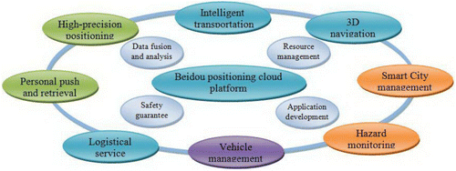
A location cloud refers to a comprehensive integration of 3S (RS, GIS, GPS) techniques, IT technology, the Internet, and communications technology and consists of the fundamental infrastructure, service,and development platforms, as well asproduction and operation solutions.The ultimate goal of a location cloud is to collectall the information available related to specific geographic locations so as to provide location-based services for a variety of applications. Currently, a location cloud in a smart city leads to three significant transforms: from a single GPS system to a more compatible global navigation satellite system (GNSS), from car-orientedapplicationsto individual consumptionservicescombined with telecommunication technology, and from product sales-orientation to service provision-orientation.Figure shows the concept of a location cloud based on the Beidou (Compass) positioning systembeing built by the Chinese navigation industry.Based on the current 16 satellites, services including positioning, retrieval, and surveying can be provided for ships, cars, and cell phones.Unlike the popular GPS, Beidou can determine the positions of a lost device,a user,or a user group.
Figure 3. A location cloud based on the Beidou positioning system
4.2 Remote sensing cloud
A remotesensing cloud Citation[19]refers to a virtual home for a large volume of distributed remote sensing data and complex processing and analysis algorithms. Users who subscribe tohigh performance cloud computing servicesonly need to choose the input data and select the appropriate algorithmsto obtain the final outcome. Since massive amounts of remote sensing data and complicated remote sensingmethods arestored in the cloud computing platform, no application-tailored computing environmentis needed,with the merit of scalable computing capabilities of cloud computing.A typical service of the remote sensing cloud consists of the following steps:
| 1. | A service provider registers online an available service (e.g.,“binarization”under the service type “conversion service.” | ||||
| 2. | Another service provider registers online an available service “change detection” as the service type “image analysis.”An annotation called“change detection between two different images” maybe attached. | ||||
| 3. | A user inquires about the available registered services once logged in. | ||||
| 4. | An abstract service chain is establishedbased on a user’s request (e.g.,“flooding area analysis”). | ||||
| 5. | The abstract service chain is mapped to an executable service chain. | ||||
| 6. | The executable service chain invokes the necessary algorithms to computethe flooding area. | ||||
4.3 Integration of video and GIS
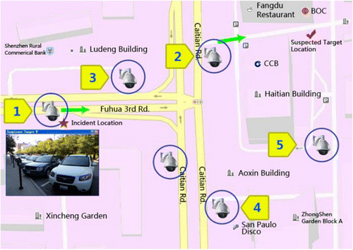
The significance of integrating videowith GIS Citation[20] is a paradigm shift from processing static data to dynamic data. Combining 2D maps and 3D models with video imagesenables a complete spatio-temporal scene description and understanding. For example, dynamic images from nearly 250,000video cameras underthe Smart Eye project in Wuhanare integrated into a GIS platform, which makes it feasible for the control center to monitor the streets of primary interest, update real-time information through video cameras, and carry out complicated GIS analysis.
Figure illustrates an example of spatial analysis in asmart city.In this stolen car incident, the data isdisplayed on a videoimage. Based on the road network in digital maps and knowledge about the vehicle’s moving speed, a suspicion target can be determined quickly through automatic positioning and retrieval from the closest neighborhood in the monitoring network. When the spatial distribution, temporal distribution, appearing sequence, and appearing frequency of the suspicious targets are acquired, possible false alarms can be eliminated.
Figure 4. Spatial analysis under the integration of video and GIS
4.4 Integration of space-borne, air-borne, and terrestrial sensorsand GIS
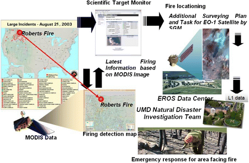
The integration of space-borne, air-borne, and terrestrial sensors Citation[21,22] makes real-time data acquisition possible based on users’ demands. For this purpose, the Open Geospatial Consortium (OGC) has published several standards Citation[23]. Figure is an example of quick emergency response to a forest fire using the sensor web technique.
Figure 5. Integration ofspace-borne, air-borne, and terrestrialsensors for a forest fire (from 23)
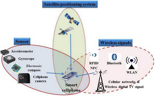
4.5 Indoor and underground navigation
Three methods can be exploited to makeindoor positioninga reality for a smart city. The first and most popular method is to gather sensor and wireless signals by smart phones. The second method, as illustrated in Figure , utilizes the GPS signals of outdoor mobile phones and their telecommunication with indoor mobile phones. The third method relies on existing 3D urban models and indoor control points. Positioning a smart phone indoorsis achieved throughapplying photogrammetric techniquestothe images of the controlled indoor scene.
Figure 6. Methods for indoor navigation
4.6 Ubiquitous sensing via smartphones
Aprediction by the WirelessWorld Research Forum in 2006estimatesthat there will be seven trillion sensors deployedby2017 Citation[13]. Anyone with any kind of sensor can be regarded as a data gathering unit in the Internet of Things, whichmakes every person a significant mobile and real-time node in the entire sensor network.In this sense, every person is seen as anindependent sensor, which makes traditionaldata users “data gatherers” at the same time. Thus, citizens become voluntary geographers.
4.7 Spatio-temporal data mining
In traditional urban monitoring systems, video streams aretraced and displayed on multiple TV screens, and suspected incidents are visually identified by human operators.This treatment of course cannot predict and control criminal events in a timely manner; for example, clues about the perpetrator of the London subway blasts in 2005 were foundafter painstakinglysearching a large volume of video archives, which greatly delayed the criminal investigation.Asmart cityoffers more intelligent video mining techniques as an alternative. Different frames of video streams can be efficiently analyzed to identify, track,and recognize moving objects; and behavior evaluation ofhumanmovement and gesturescan be conductedto locate and predict potential suspects.
5 Applications of Smart Cities
Smooth, efficient, and intelligent municipal operations can be expected in a smart city, but collaborative interaction among individuals, enterprises, organizations, and agencies are necessary,as well as communication between the real anddigital worlds. Theconstruction of a smart citycanfacilitate a thriving economy bystimulatingthe commerce of digital citiesin a short period of time. Numerousjob opportunities can be provided because a smart cityrequiresinvestment in several fundamental infrastructures, such as smart electronic networks, smart architecture, and smarttransportation. Also,since more types of services for urban citizens can be provided, a smart city can serve to accelerate the city’s development and produce more social wellbeing. Finally, the infrastructure of a smart city offers possibilitiesfor industrial innovation, transformation, and upgrading in the future.Some application examples of a smart cityare described below.
5.1 Smart municipalsupervision
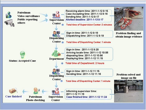
Smartphones can be used assensorsfor smart municipal supervision. In the case of Wuhan city, statistics show that there are two million objects or items, more than 9.7 million people, and over 0.6 million events, all of which are related to urban management. All of the above need to be effectively managed in a smart cityframework consisting of infrastructure, people,and events through data acquisition and intelligent analysis. Figure shows an urban management procedure based on intelligent mobile phones.
Figure 7. An example of smart municipal supervision
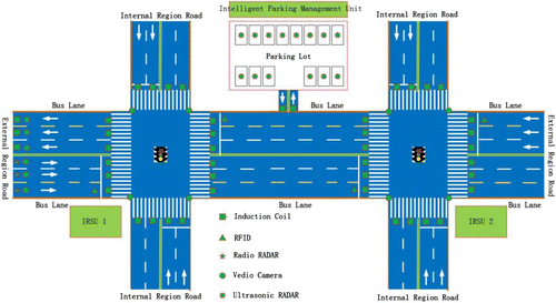
5.2 Smart transportation
Current traffic management is confined to a restricted scopedue to several limitations. Drivers choosetheirown driving routes, for instance,based on their personal knowledge and experience, which often results in traffic congestion and inefficient usage of certain urban road resources. With instant traffic flow information, street conditions, temperature,and traffic accidents recorded by sensors, a smart city can achieve real-time communication among people, vehicles, street conditions, and the environment for the purpose of route choice. It can also provide dynamic and optimized transportation plans and driving routesthrough cloud computing. As illustrated in Figure , intelligent road-side units(IRSUs) are installed on both sides of the roads,road intersections,parking lots,bus stations, and bicycle renting stations. Asan integration of hardware and software equipment which contains the power supply,computer,data acquisition unit,cable and wireless communication devices,etc., IRSUscan be in different formsdepending ontheir diverse locations. For example, they can be an outdoor monolithic machine cabinet at road intersections, an electronic bus-board,a variable information board at the bus stop, etc.
Figure 8. A smart urban transportation system
5.3 Smart environment monitoring
A mobile environmental monitoring system based on multiplesensors has been developed in Wuhan to monitor the urban environmentmore effectively (Figure ). This is regarded as a supplement to the existingfixed environmental monitoring stations (e.g., hydrologic, water quality, and atmospheric stations).Such mobile systems can collect in situ data and transmit them to a central station through wire or wireless networks to applyautomatic online monitoring of pollutantsources and environmental quality. In general, a mobile environmental monitoring system willperformdataacquisition, integration, and analysis as well asautomation,intelligence,and visualization of data processing. Its features are described below:
| 1. | Air pollutant concentrations like PM2.5, water pollutant concentrations, noise intensities, and other environmental parameters can be acquired usingvehicle-based environmental sensors. | ||||
| 2. | As the outcome of environmental data processing,the resultscan be eitherin chart formorexploited for further analysis and deduction, all of which helpto comprehensively understand thestate of the surrounding environment. | ||||
| 3. | Digital Measurable Images (DMI) generated by mobile sensors can be used to make rapid and non-contact measurementsfor the location and determination of the dimensions of objects of interestand facilitate the presentation and analysis of environmental data. | ||||
| 4. | Based on the integrated positioning of the Global Position System/Dead Reckon (GPS/DR),the location of environmental information can be achieved accurately for further environmental analysis. | ||||
| 5. | The gathered data can be transmitted by wireless networks or satellite communication modules. | ||||
Figure 9. The interface of a mobile environment monitoring system integrated with digital measurable images, digital maps, and environment sensors
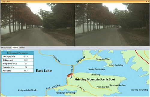
Figure is the interface of a vehicle-borne environment monitoring system, which carries various environmental sensors and displays digital measurable images and digital maps for navigation and geo-referencing purposes.Through the digital images and maps, the correspondence between the environmental parameters and their locations is established. In Figure , TSP stands for total suspended particulate.
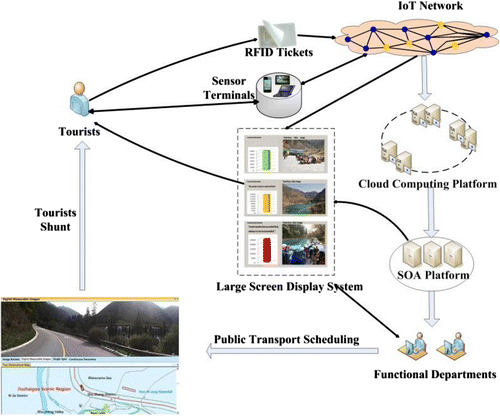
5.4 Smart tourism
The integration ofdigital measurable imagesand electronic maps enables the provision of spatial information, economic information, cultural information, social information, and the attributes of objects in one platform. This often can be customized forthe needs of different users. Figure shows our Smart Jiuzhaigou Project, in which all service functions are built to satisfy tourists’ needs.The integration of multi-sensors,such as RFID at scenic spots, ensures that dynamic information isdisplayed in a timely manner on the LED screens at all road intersections.The detailed workflow of the touristsshunt optimization is illustrated in Figure . Uponentering the Colorful Lake scenic spots, atourist’s data along with the RFID ticket number are sent to a cloud computing platform for data processing and analysis through the Internet of Things. Then,a Service-Oriented Architecture (SOA) platform transforms the information into different kinds of service flows. On one hand, the operationsdepartment will receive in realtime the total number of current touristsand decide if a new tourist should be allowed to enter the scene. More public service buses will be sent to a “hot” location according to the degree of crowdedness shown on their GPS e-maps. On the other hand, the touriststhemselves will be reminded by the LED screens that the spot now is not available for more tourists and receive a suggestion of visiting other alternative spots.
Figure 10. A framework ofsmart tourism
6 Conclusion
This article introduced the concept of digital cities and smart cities. The former is a fundamental framework for the latter, whereas the latter is more application- and service-oriented. A smart city has distinct propertiesfrom a geomatics point of view, which include seamless integration with digital cities, a network of sensors, and capabilities for self-networking and self-maintenance. However, a digital city and a smart city will no longer be separated butintegrated and fused as one entityin the future.In reality,data or information from smart sensor networks can be updated and published under the infrastructure framework of a digital city, resulting ineasier interactionbetween humans and machines. Massive amounts of datacollected in real time in a smart city can be instantly analyzed and processed using cloud computing platforms, which will ultimately provide support to urban management via smart sensor networks. Implementation examples of smart municipal supervision, smart transportation, smart environment monitoring, and smart tourism arepresented to support the discussion.
The supporting techniques of smart cities, among others, are digital cities, the Internet of Things, and the emerging cloud computing, which respectively provide the basic frameworks for geo-referencing and spatial-temporal modelling, real-time sensing and communication, and online computation and analysis. In spite of recently successful applications of smart cities, a number of potential technology developments for a smart city are worthy of further study. A location cloud is representative of an integrated mobile data collector that needs transitions to a more integrated and flexible sensor system. A remote sensing cloud, as a powerful data processing engine, demands support from industry to populate effective processing tools online. Similarly, the integration of GIS with video and diverse sensor platforms is on the horizon as well asan answer to the demandfor faster and more intelligent data processing and mining techniques. It is also noted that smart phones are playing an increasingly importantand indispensable role in indoor navigation and the daily life of citizens, both of whichhave not yet attracted much attention from either academia or industry.It is believed that future development of smart cities will be driven by new technologies and achievements from interdisciplinary frontier subjects. Meanwhile, environmentally-friendly and harmonious solutions to social problemswill become a challenge and concern in the development of smart cities.
Notes on contributors:
Li Deren is an academician of the Chinese Academy of Sciences and an academician of the Chinese Academy of Engineering. He is mainly engaged in geomatics research and education in the fields of remote sensing, geographic information systems, and satellite positioning systems.
Shan Jie is a professor in the School of Remote Sensing and Information Engineering at Wuhan University and School of Civil Engineering at Purdue University. He is mainly engaged in research and education in remote sensing and geographic information systems.
Shao Zhenfeng is a professor in the State Key Laboratory of Information Engineering in Surveying, Mapping, and Remote Sensing at Wuhan University. Heis mainlyengaged in Smart City research and education based on remote sensing and geographic information systems.
Zhou Xiran is a graduate student in the State Key Laboratory of Information Engineering in Surveying, Mapping, and Remote Sensing in Wuhan University. His study involves geographic ontology and spatialinformation mining.
Yao Yuan is a Ph.D. candidate inthe School of Remote Sensing and Information Engineering in Wuhan University. His study involves dynamic 3D modelling and Smart Cityimplementation.
Acknowledgment
This work is sponsored by the National Basic Research Program of China (No.2010CB731800), National Natural Science Foundation of China (No.61172174 and No.10978003) and National Science & Technology Specific Projects(No.2012YQ16018505 and No.2013BAH42F03).
References
- Giffinger, R., C. Fertner, H. Kramar, R. Kalasek, N. Pichler-Milanovic, E. Meijers, 2007. “Smart cities – Ranking of European medium-sized cities”. http://www.smart-cities.eu/. Vienna: Centre of Regional Science. http://www.smart-cities.eu/download/smart_cities_final_report.pdf.
- Tranos, E., Gertner, D., 2012. Smart networked cities? Innovation-The European Journal of Social Science Research 25(2) SI, 175–190.
- Shapiro , J.M. 2006 . Smart cities: Quality of life, productivity, and the growth effects of human capital . Review of Economics and Statistics , 88 ( 2 ) : 324 – 335 .
- Dignan, J., 2011. Smart Cities- Connected Government Framework for Smart Cities, http://www.smartcities.info/files/03%20-%20Joe%20Dignan%20-%20Microsoft.pdf.(accessed 20th December, 2012).
- Harrison, C., B. Eckman, R. Hamilton, P. Hartswick, J. Kalagnanam, J. Paraszczak, P. Williams, 2010. Foundations for Smarter Cities. IBM Journal of Research and Development54(4), pp. 1–16.
- Gore, A., 1998. The Digital Earth: Understanding our planet in the 21st Century. http://www.zhanpingliu.org/research/terrainvis/digitalearth.pdf. (accessed 20th December 2012).
- Sun , X.L. 2000 . Digital Earth and Digital China . Studies in Science of Science , 18 ( 4 ) : 20 – 24 .
- Li , D.R. and Shao , Z.H.F. 2009 . The new era for geo-information . Science in China-Information Sciences , 52 ( 7 ) : 1233 – 1242 .
- Goodchild , M.F. , Guo , H.D. , Alessandro , A. , Bian , L. , de Bie , K. , Campbell , F. , Craglia , M. , Ehlers , M. , van Genderen , J. , Jackson , D. , Lewis , A.J. , Pesaresi , M. , Remetey-Fülöpp , G. , Simpson , R. , Skidmore , A. , Wang , C. and Woodgate , P. 2012 . Next-generation Digital Earth . Proceedings of the National Academy of Sciences USA , 109 ( 28 ) : 11088 – 11094 .
- Li , D.R. , Gong , J.Y. and Shao , Z.H.F. 2010 . From Digital Earth to Smart Earth . Geomatics and Information Science of Wuhan University , 35 ( 2 ) : 127 – 132 .
- ITU, 2005. ITU Internet reports 2005: the Internet of Things. http://www.itu.int/osg/spu/publications/internetofthings/. (accessed 20th December, 2012).
- Li , D.R. , Shan , J. and Gong , J.Y. 2009 . Geospatial Technology for Earth Observation , Dordrecht : Springer Press .
- Uusitalo , M.A. 2006 . Global visions for the future wireless world from the WWRF . IEEE Vehicular Technology Magazine , 1 ( 2 ) : 4 – 8 .
- Venters , W. and Whitley , E.A. 2012 . A critical review of cloud computing: researching desires and realities . Journal of Information Technology , 27 ( 3 ) : 179 – 197 .
- Zhang, Q., Cheng, L., Boutaba, R., 2010. Cloud computing: State-of-the-art and research challenges.Journal of Internet Services and Applications. 1(1), 7–18.
- Guo , W. , Gong , J.Y. , Jiang , W.S. , Liu , Y. and She , B. 2010 . OpenRS-Cloud: A remote sensing image processing platform based on cloud computing environment . Science China-Technological Sciences , 53 ( 1 ) : 221 – 230 .
- Li , Z.H. 2008 . Digital Urban Spatial Data Infrastructure and Applications , Beijing : Science Press .
- Future Cities Laboratory. http://www.futurecities.ethz.ch/. (accessed 20th December, 2012).
- Ren , F.H. and Wang , J.N. 2012 . Turning remote sensing to cloud services: Technical research and experiment . Journal of Remote Sensing. , 16 ( 6 ) : 1331 – 1346 .
- Lewis , P. , Fotheringham , S. and Winstanley , A. 2011 . Spatial video and GIS . International Journal of Geographical Information Science. , 25 ( 5 ) : 697 – 716 .
- Li , D.R. and Shen , X. 2005 . On intelligent earth observation systems . Science of Surveying and Mapping. , 30 ( 4 ) : 9 – 11 .
- Li , D.R. , Tong , Q.X. , Li , R.X. , Gong , J.Y. and Zhang , L.P. 2012 . Current issues in high-resolution earth observation technology . Science China-Earth Sciences. , 55 ( 7 ) : 1043 – 1051 .
- Mandl, D., 2004. Experimenting with sensor webs using earth observing 1. Proc. IEEE Aerospace Conference, Big Sky, 6–13 March, pp. 176–183.