Abstract
It is our goal to make today’s and future cities smart, sustainable and resilient. In order to achieve this, it is fundamental to understand how each city works, to formalize the knowledge gained and to apply it to a city model as the base for simulations that can generate future scenarios with a high level of probability. The nature of this model, which must cover design, qualitative and quantitative aspects, has changed over time. In this study, we focus on the role of the spatial dimension and of geometry in a city model. Emerging from being a dominating generative force in ancient cities, spatial modeling has developed into an underlying description language for present and future cities to define functions and properties of the city in space and time. The example of the stocks and flows model applied to the city depicts where and how spatial modeling influences the design, construction and performance of the future Smart City.
1 The role of geometry and space in the continuum of city modeling
Early architecture and urban design examples are based on fundamental geometric shapes: point, line, circle, square, and rectangle. Besides the purity of these forms, they have the advantage that they can be constructed easily with simple tools. They could straightforwardly be assembled into grids, thus providing the footprint for the basic organization of urban services and separating public from private areas. For the arrangement of these shapes and infrastructure networks, city planners defined simple rules and instruction sets which, in combination with the shapes, would form a design description that could be easily taught to others (Figure ).
1.1 The rule-based approach
With the growing complexity of settlements into urban centers and denser cities, the simple instruction sets became less effective and could in fact diminish the overall performance of the city or hinder it from achieving its defined goals. The definition of those functional goals became priority, geometry had to follow. The geometric pattern of the city was brutally altered accordingly, as the example of the redesign and reconstruction of Paris in the nineteenth century demonstrates. In this and other cases, geometry was put into the service of other, for example military goals, rather than being the generative driver of city form. Yet the planning intentions and the results of interactions between basic geometry and political or private goals were still visible.
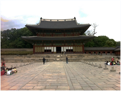
Figure 1 Changdeokgung Palace in Seoul from 1405: geometry as the driving force underlying the design. Photo: Gerhard Schmitt, 2011.
1.2 The stocks and flows approach
With growing sophistication of societies and politics, technology and economy, cities changed their geometry again. Linear transportation systems such as freeways, train tracks and suburban private roads gained in importance and reshaped the design of cities. Economics, transportation and the separation between living and working areas became dominant factors. With less limitations in materials and increased freedom in design, driven by a temporary abundance of cheap energy in the twentieth century, the geometric expression of the city became increasingly a result of the various stocks and flows that determined city life, leading to sometimes ordered, but sometimes seemingly chaotic conditions of a city’s geometry (Figure ).
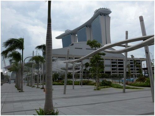
Figure 2 The Marina Bay Sands complex in Singapore by Architect Moshe Safdie, an early twenty-first century example for an integrated resort complex. Photo: Gerhard Schmitt, 2011.
1.3 The complex system and quantum city approach
With the beginning of the twenty-first century and the globalization of city stocks and flows, the dependence of the city on its direct hinterland decreases, and even national networks of cities for the exchange of goods and services lose their dominance. The forces that cities are exposed to start to shift rapidly, thus making them in their development increasingly the result of changing force fields – force fields in the sense of rules governing the balance of the complex system of the city. This leads to metaphorical analogies with quantum theory and thus to the proclamation of the quantum city, as proposed by Arida Citation(1) or Hovestadt Citation(2). At this stage, geometry takes on a new role, but it still is and will be decisive for the positioning of any physical manifestation of city stocks and flows and force fields.
2 The role of reality-based 3D data for city modeling
Most of the cities from previous centuries have disappeared, but those with sustainable and resilient qualities have survived. These cities are of particular interest as models for future Smart Cities. In early civilizations, we see descriptions of cities in words, in diagrams, in pictures, and in models. The written description of city life has dominated over centuries, with more or less precise references to spatial issues in those cities. Those descriptions are crucial, because they connect qualitative properties of city life with spatial issues. Yet to model a city completely, it also takes the precise definition of its location in space over time. To this end, diagrams and later images, drawings, perspectives, and 3D models emerged. To capture the dynamic aspects of city growth architects and engineers developed increasingly sophisticated models. These models are the foundation of today’s simulations, and in those simulations, reality-based 3D information plays a major role. Reality-based 3D information is like a snapshot in time.
3 The role of spatial modeling issues in cities
While location, climate, politics, and social conditions vary greatly from city to city, one description applies to all of them: geometry as the basis of spatial modeling. Spatial modeling has a crucial role in future Smart Cities as it assigns unique positions to all properties and stocks and flows in a city. Spatial modeling is also indispensable to differentiate between the territory or countryside, the urban settlement or the city, and the individual building and its surrounding.
4 Spatial modeling and the stocks and flows model
The majority of today’s cities have reached their present size in the late twentieth and early twenty-first century. Worldwide, the unprecedented population increase during this time – first in areas with temperate climates and now in areas with tropical climates – has forced city planners and designers to rely on models that had proven successful in the past. Thus, most of the recent city growth is the result of a combination of the geometry and rule-based approach, overlaid with the stocks and flows model Citation(3). The rule-based approach is clearly geometric in nature, but also for the stocks and flows model geometric precision is crucial.
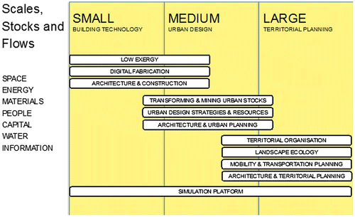
The following will be examples for spatial modeling issues for the stocks and flows approach. The associated research is conducted in the Future Cities Laboratory at the Singapore–ETH Centre for Global Environmental Sustainability, which has assembled a team of more than 100 researchers and students to explore and understand the character of the future city Citation(4). Researchers work in 10 independent, but related modules focusing on individual or combinations of stocks and flows, and in three assistant professorships. The following paragraphs describe the spatial modeling issues of each one of those stocks and flows (Figure ).
4.1 Stocks and flows of material
Construction material is the basic component for buildings and cities. Its positioning in space decides on the accessibility, density and spatial quality of a city. An original spatial issue is the mining, the transportation and the deployment of the material in the city. In ancient times, the city’s hinterlands provided most of the material. Yet even more than 3000 years ago, building material transport could cover hundreds of miles, using rivers to arrive at the final destination for the construction of Egyptian temples and pyramids. Today, countries such as Singapore with an extreme scarcity of building materials have to import them from destinations around the globe, so that the material flow is global before it turns into a temporary material stock in the constructed city. Thus spatial issues are first dynamic in the sense of transportation and then become static once the material has been cast in place. After a large amount of building stock has accumulated in the city and begins to age, it becomes a new source for material flow, in that buildings are taken down, recycled and used for the construction of new buildings. In Singapore, this recycling can reach more than 90%. As the recycling cycles become shorter and shorter, the spatiotemporal development of the city can be observed almost in real time, leading to the necessity of 4D Singapore: the spatial monitoring of the building material stocks and flows in real time.
Figure 3 The working model of the Future Cities Laboratory. The columns depict the different scales: small–buildings and building technology; medium–urban design; and large–territorial planning. Stocks and flows on the left are translated into research projects on the right. Cheryl Song, 2012.
4.2 Stocks and flows of energy
On first sight, stocks and flows of energy seem to have little to do with spatial issues. Yet on closer examination, there is a direct relation between the shape and orientation of buildings and the amount of energy needed to keep them at comfortable conditions for living and working. Independent from temperate or tropical climates, the density of the building stock, a primary spatial condition, influences the stocks and flows of energy in the city. In addition, the geometric layout of infrastructure influences the stocks and flows of transportation energy to high degree. An example is the difference between the spatial layout of a suburban community and high-density housing in the city that has direct impact on transport energy.
4.3 Stocks and flows of water
Roughly speaking, a lake or a reservoir could be considered a stock of water in the city, and rivers and creeks, along with the underground water pipelines, characterize flow. The spatial dimension of stocks and flows of water represent a considerable percentage of a sustainable city’s area. On the negative side, flooding has become a growing threat to cities worldwide be it through intense rainfall or through out of control rivers. The quick spatial assessment of the damage caused by flooding from the air through unmanned aerial vehicles will intensify in the coming years. More important, this assessment, combined with a three-dimensional reconstruction of the flood protection devices is crucial for the avoidance of future damage. The Future Cities Laboratory is conducting research in this direction in the city of Jakarta and the Ciliwong River, because the improvement of the situation upstream is a precondition for a less dangerous river downstream. Dynamic high-resolution mapping from the air and from the ground with novel photogrammetric programs is becoming crucial.
4.4 Stocks and flows of people’s positions
In the digital world, every person leaves a digital trace at any given point in time. This position can become valuable information for the conversion of existing and the development of new Smart Cities. In the world of agent-based modeling, it is perceivable that future citizens will have a mirror avatar or agent. The agents are informed by data that real people provide voluntarily. Expressed in terms of spatiotemporal information, an agent’s behavior serves as the foundation of urban design decisions. This applies both for the large-scale migration into cities from within one country or from other countries, as well as for the movement of the individuals within the city on a daily basis. Whereas the former applies to the large-scale and territorial flow of people’s positions, the latter depicts the daily movements of people between living, working and entertainment activities. The agent-based transportation simulation programs such as MATSim Citation(5) that are used at the Future Cities Laboratory are by now able to simulate the daily positions of more than 5 million Singaporeans. Combined with the generative power of programs such as CityEngine Citation(6) and with economic analysis programs, they offer an unprecedented design tool for the future.
4.5 Stocks and flows of finances
Finances as a virtual entity seem not to have direct spatial impact. Yet the indirect spatiotemporal effect of finances on the city and its hinterland can clearly be shown. As a matter of fact, finances could be considered as one of the major drivers of spatial developments, as they fuel the economy and lead to preferences of investors and governments in terms of making spatial decisions in existing and new cities. Examples are the arrival of large supermarkets in North America and Europe in the twentieth century, which led within a short time to large shopping malls outside the city, generating new commercial landscapes and private transportation lines, but in some cases also making the inner cities more attractive by turning them into pedestrian zones. Another example is the concentration of capital and labor in high-tech production areas, which in turn lead to intense growth and new spatial arrangements, such as in Shenzhen.
4.6 Stocks and flows of information
Information and information structures define the Smart City. Information, similar to finances, is a virtual entity with indirect impact on the spatial arrangement of cities. Information storage, through its immense demand for electricity and cooling, begins to have also a direct spatial impact on cities. Consider, for example, that the Swiss national supercomputer Centre was not built in the city of Lugano in order to avoid a massive heat island effect in the inner city, which would have decreased the environmental quality of the surrounding. Or consider the situation that data centers would be located close to gigantic cattle farms, in order to use the electricity generated by the biogas derived as a by-product of cattle farming. A third example is the new form of knowledge acquisition through individual crowd sourcing and wireless technologies. They allow existing cities and its parts to take on new roles as working and information gathering spaces. In addition, cloud-based computing will free many cities in developing countries from their previous reliance on network infrastructure. Finally, the individualized and decentral generation of electricity for future information devices might lead to a large information space encompassing the entire city and to decentralized information processing centers outside of the city fuelled by large alternative energy plants.
4.7 Stocks and flows of density and space
It is unusual to apply the principle of stocks and flows to space and density, yet it is crucial for the understanding and for the improved sustainability of existing and new cities. The twentieth century has seen an increasing decentralization and spread of the cities into their surrounding areas. A reverse development characterizes the late twentieth century and the beginning of the twenty-first century. Both were the result of arguments for more quality. How could that be? The combination of cheap land and cheap transportation energy and rapidly growing populations in North America and Europe allowed for the spatial expansion and reduction of density, leading to ever-increasing infrastructure costs, use of space, and environmental problems. The rapidly growing population in the late twentieth century combined with higher energy costs, cumulative environmental damage and less available space encouraged higher density. This, however, will only work if the societal model is one that is able to work with higher density and looks at value creation not only as the consumption of more products and space. It also requires the individual acceptance of living and working closer together with others. While in Switzerland, the personal space use has increased from less than 30 m2 in 1960 to almost 50 m2 in 2010, this number is even double in Australia. But it is only a fraction of this in emerging countries. Density has a significant impact on energy consumption and on the CO2 footprint of a city and is therefore a major spatial issue (Figure ).
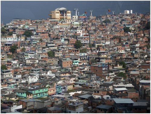
Figure 4 Favela Morro do Alemão in Rio de Janeiro: an overlay of several force fields with decreasing density over time. Gerhard Schmitt, The 2012.
5 Summary
While the role of geometry and spatial issues as underlying properties of existing and future Smart Cities have drastically changed over the centuries, they continue to be foundations for urban design decisions. Geometry might have lost its direct impact in terms of a primary decision tool, but it has gained impact in terms of locating and relating the different properties and stocks and flows that are important to design, construct and manage the sustainable and smart city of the future. The effects of the stocks and flows of material, energy, water, people’s positions, finances, information, density and space are visible in any city. They are computable and thus offer a welcome common language to the otherwise very dissimilar description languages of the individual impact factors defining a city. As a result, it is highly welcome and necessary to formalize and strengthen the connection between the individual properties and developments and spatial issues of the future Smart City.
Notes on contributors
Gerhard Schmitt is Professor for Information Architecture at ETH Zurich, Director of the Singapore-ETH Centre in Singapore, and ETH Zurich Senior Vice President for Global Affairs.
Since 2010, Gerhard Schmitt leads the Singapore-ETH Centre for Global Environmental Sustainability. It started with the establishment of its first trans-disciplinary project, the Future Cities Laboratory, which rapidly evolves into a global think tank and scenario simulation institute for the sustainable development of new and existing cities.
From 1998 to 2008, he served as Vice President for Planning and Logistics and Member of the Board of ETH Zurich. He directed the development of ETH’s strategy and planning in cooperation with the 16 scientific departments and the central administration. He was also responsible for Human Resources, for departmental budgeting and for the infrastructure of ETH Zürich on two major campuses.
In 2010, Gerhard Schmitt received the European Culture of Science Award for ETH Science City.
Acknowledgments
The author wants to thank the team of the Future Cities Laboratory of the Singapore–ETH Centre for Global Environmental Sustainability. Special thanks to the members of the Simulation Platform. This research is funded by ETH Zürich and by the Singapore National Research Foundation. The publication is supported under the Campus for Research Excellence And Technological Enterprise (CREATE) program.
References
- Arida , A. 2002 . Quantum City , New York : Routledge .
- Hovestadt, L. Urbanität und der Reichtum an sauberer Energie. Academia Engelberg, 2012. http://www.academia-engelberg.ch/2._kongresstag_13.9.2012.php5 (accessed Nov 13, 2012).
- Müller Arisona , S. , Aschwanden , G. , Halatsch , J. and Wonka , P. 2012 . Digital Urban Modeling and Simulation , Berlin : Springer .
- Singapore ETH Centre Future Cities Laboratory Home Page. http://www.futurecities.ethz.ch (accessed Nov 14, 2012).
- MATSim Home Page. http://www.matsim.org (accessed Nov 14, 2012).
- Esri CityEngine Home Page. http://www.esri.com/software/cityengine (accessed Nov 14, 2012).