Abstract
As urbanization process has been and will be happening in an unprecedented scale worldwide, strong requirements from academic research and practical fields for smart management and intelligent planning of cities are pressing to handle increasing demands of infrastructure and potential risks of inhabitants’ agglomeration in disaster management. Geospatial data and geographic information systems (GISs) are essential components for building smart cities in a basic way that maps the physical world into virtual environment as a referencing framework. On higher level, GIS has been becoming very important in smart cities on different sectors. In the digital city era, digital maps and geospatial databases have long been integrated in workflows in land management, urban planning and transportation in government. People have anticipated GIS to be more powerful not only as an archival and data management tool but also as spatial models for supporting decision-making in intelligent cities. Successful applications have been developed in private and public organizations by using GIS as a platform for data integration, a system for geospatial analysis and collection of models for visualization and decision-making. Location-based services on smart mobile devices in ubiquitous telecommunication networks are now an indispensable function that expands knowledge of the nature and connections among people. On data side, crowd-sourcing, real-time urban sensing and true 3-dimensional (3D) models and visualization have provided more advantages of GIS to final users and at the same time challenged current available solutions and technologies of data handling, visualization and human–computer interaction. On the technological side, Web 2.0 participatory applications provide the framework and environment for GIS to closer link to photogrammetry and computer vision, which empowers smart devices more capabilities. How to manage big geo-tagged data volumes collected by numerous sensors and implement professional GIS functions in a cloud computing environment are urgent questions to facilitate smart cities management. This paper reviews advancements of GIS in the management of cities as information systems to facilitate urban modelling and decision-making, as referencing basis to integrate social network media, and concludes that an interdisciplinary urban GIS is needed to support development of smart cities. We take Singapore as a case of GIS pervasive applications, which has strategically made a master plan of national information infrastructure and has been implementing geospatial collaboration environments for public and private sectors.
1. Introduction
Modern cities are complex systems and engines for the acceleration of human society development. At the same time, cities are consuming resources from nature and producing wastes to environments at a much higher rate than other living styles Citation(1). Urban areas have been accommodating more and more inhabitants who are further contributing to high densities of infrastructures and resources with heavy impacts on global climate and environmental changes. By 2050, urban dwellers will be expected to account for 67% of the world population, which is approximately 6.3 billion Citation(2). The climate changes and social problems are causing high risks of disaster and unsustainable development to cities. Ever faster urbanization processes and growing population densities reinforce people’s concerns on better understanding, planning and managing infrastructure, economy and society in cities to achieve liveability and sustainability. Policy-makers partnered with urban planners, geographers and economists have long been making every endeavour to address the challenges at municipal, country and international levels Citation(2). A smart way is commonly requested for building long-term sustainable cities Citation(1 , Citation 2). Due to the high degree of complexity of urban issues, information and communication technologies (ICTs) have long been used to facilitate scientists and practitioners to manage the urban infrastructures and improve the efficiency of many working procedures in government agencies Citation(3), Citation(4). Since a high percentage of information managed in public sectors, especially in planning, is geo-referenced Citation(5), geographical information systems have gained their popularity at very early time in urban planning, transportation modelling, risk management and geo-demographics Citation(4 , Citation 5 , Citation 6 , Citation 7). As an essential part in a much wider scope of ICTs in urban management, geographic information systems (GISs) have been undertaking revolutionary changes in the last half century and became a basic tool for the treatment of urban issues and finding related solutions. Urban modelling and urban information system have been an important research direction of GIS applications in cities all the way Citation(8). With the widespread conception of smart cities, which is believed to be a pivotal way to handle challenges of global urbanization Citation(9), it is necessary to undertake a review of advancements of GIS concerning its applications to smart city developments, its areas and contexts, technical adaptations at different scales, potential performances and future research directions.
1.1 GIS and science
Half a century ago, Tomlinson proposed the feasibility of and started the Canadian GIS based on computers for inventory management, analytical processes and automatic mapping of natural resources in 1963. Since then, academic research and commercial development of GIS have soon gained popularity worldwide. It had been conceptualized and defined during the next 30 years as system for digitizing, storing, managing, analysing and representing geographic information based on various abstract models with finite accuracy Citation(10), before researchers realized that it would change the world not only on the technical side, but also on the social and cognitive sides, which eventually constitute GIS Citation(11). In the following text, GIS is used to denote both meanings of “System” and “Science” without explicit explanation.
Although the visualization software of many GIS is still lacking full consideration of traditional cartographic design rules, aesthetic and information communication criteria, a GIS has much more power than static maps, because of the segregation of geospatial data from graphic representation, the integration with navigational needs of normal citizens, the in-depth application of spatial analytics, easiness of acquiring geospatial data and dynamic combination of various data layers including vector, raster and images. With the rapid availability of high resolution geospatial data and improvement of computer hardware performance combined with the introduction of spatial statistics and spatial analytics proposed in quantitative geography, the content and widespread applications of GIS have been substantial and are still booming.
1.2 Smart cities and science of cities
The concepts of smart cities were once proposed as technopolis or science parks, which are knowledge hubs for innovating ideas, spearheading technologies and building start-up firms in cities, such as Silicon Valley Citation(12). The agglomeration of research and development sectors reduces distances and gaps between potential demands and supplies of information and human resources. They were built and conceptualized for a small group of elites. This concept has been successful in terms of hardware, albeit few ideas, such 3D virtual reality, are proposed in quite similar scenarios as the idea of smart cities indicates today. The development of telecommunications and computing facilities provided flexibility on geographic location and dissolved the necessity to build smart cities in such context.
During this period, the terms “Global Networked City” and “Multimedia City” were also proposed to be an implementation of a technopolis society in the metropolitan area Citation(12). It was envisioned that information technologies were to be used to link the world by computer networks and transportation networks, and to solve critical issues in transportation, health and even family planning by levelling down the social pyramid and enabling average persons equally accessible to information. The flatting of social structure is also powered by ICTs and data sharing, in which GIS and geospatial data are main components. This conception was upgraded and propagated soon in a speech by Al Gore, a former vice-president of USA in one scientists’ convention, but using an ever broader definition (“Digital Earth”) with everything geo-referenced to scaleless geospatial databases Citation(13). Academic communities including geomatics researchers had soon accepted this as an opportunity for using geospatial technologies to build a digital replica of the physical Earth, in which creating digital cities was naturally taken as the first wave Citation(14). Digital cities or virtual cities come from the coining and expectation of the digital earth. The implementation of digital cities has partly achieved the first definition of smart cities in the last century, in which computing infrastructures and geospatial databases based on 2D maps are normally built up in economically moderate cities. Service-oriented architectures (SOAs) and software solutions of traditional working procedures in government are also developed, for citizens and visitors.
Based on digital cities, intelligent cities distinguish themselves by seamless SOA integration with other fields and pervasive processes in decision-making, which can be accelerated by geospatial resources and technologies. As indicated in Section 1.1, wide availability of high resolution geospatial data is important to advancement of GIS and also crucial to intelligent cities. This period sees the quick popularization of virtual earth applications such as Google Earth (previously Keyhole Earthviewer), Microsoft Virtual Earth (now Bing Maps) and NASA WorldWind.
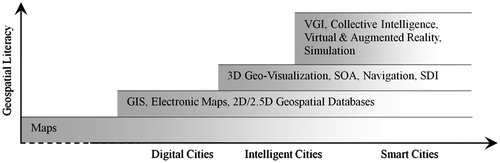
The term smart city has been used by urban planners for some time, but only being fashionable at a specific time when several key factors come together, which include fast urbanization processes, demands of economic recovery and booming of virtual communities based on Web 2.0 and social media. Caragliu and Del Bo Citation(15) defined a smart city as “ … investments in human and social capital and traditional (transport) and modern (ICT) communication infrastructure fuel sustainable economic growth and a high quality of life, with a wise management of natural resources, through participatory governance”. The core ideas suggested by other researchers in urban performance metrics and ranking Citation(16 , Citation 17 , Citation 18) are sharing similar connotations and common elements including people, transportation and mobility, environment, economy, living and governance. It is very clear that in most of these six dimensions, geospatial data and GIS should play an essential role to improve the degree of smartness by providing a geo-referencing framework for the virtual environment, an integrative platform for information organization, an intelligent system for geo-analysis in decision-making and a context-adaptive means for public information sharing. At the same time, smart cities pose new challenges to academic and research communities for ground-breaking investigations related to urban inhabitants and liveable environment, which constitute a complex science of cities Citation(8) and a unified theory of sustainability with cities Citation(1). In many aspects, GIS is pivotal to collect and integrate data, reveal where the problem is, how the surrounding context is, which solutions can be designed and which ones are optimal at different scenarios in a dynamic environment. Figure shows the growing of typical geospatial literacy over advancements of intertwining development stages of cities.
Figure 1 Geospatial literacy growth in modern versions of cities.
Following a short summary of the development of smart cities and GIS above, this paper reviews typical applications of GIS in the building of smart cities, including transportation and mobility, risk management and urban planning. The (geo)Spatial Data Infrastructure (SDI) is emphasized as a common basis to improve consistency and quality of results for decision-making. Then, the advancement of crowd-sourcing geo-tagged data and the role of GIS services and applications in public participatory management of cities are discussed, in which collective intelligence is reflected by efforts and outputs of volunteered geographic information. The third section reveals that an interdisciplinary urban geographic information science for smart cities is required. Major shifts of GIS advancement for the transformation to smart cities are discussed and concluded this paper.
2 GIS as systems in smart cities
A holistic investigation of smart cities requires an integrated approach accommodating innovative, sustainable and inclusive dimensions with knowledge and insights across green energy, sustainable transportation, quality environment and smart building, liveable and affordable housing, risk and resilience, water and food and many other different domains, which are much beyond the capability of one paper. This paper touches three of them which take geospatial data and GIS as fundamental elements. In smart cities, geospatial data, new products, geo-services and applications have been drastically increasing in the form of grand projects driven by government departments (e.g. Amsterdam and Dubai Smart City), and software applications and online maps by market giants to attract urban users (e.g. IBM, Google, Apple and others) and enthusiastic citizens as volunteered smart sensors Citation(11). The levelling down of social structures induced by ICTs can also be manifested in the following three GIS application fields: transportation and mobility, risk management, and urban planning. Singapore is used as a case for analysis of geospatial data and GIS in implementation of the smart city.
2.1 GIS-based transportation and mobility in cities
Transportation modes have substantial influence on the shape and size of urban forms. Different functions of a city are actually connected by street networks which are hierarchical structures in a network topology Citation(19). Urban areas have sprawled with fast increasing car ownerships and low price of fossil fuel, which provide human beings much living freedom and working efficiency. At the same time, the transportation has been the largest sector of energy consumption and the second largest of energy loss Citation(20). GIS can play important roles to reduce energy consumption and improve smartness of urban transportation during the processes of providing urban dwellers with efficient transportation solutions, achieving sustainable management of transportation infrastructures and building sustainable transportation planning.
| 1. | Navigation and way finding are the first type of function in which GIS helps urban inhabitants and visitors to get the right directions. It is also an important part of Location-Based Services and Intelligent Transportation Systems (ITS), both of which employ geospatial data as analysis basis and maps as representation. Smart integration of GIS can remarkably save commuters’ time on the road and reduce carbon emission by intelligent navigation to avoid any road congestion. Theoretically, it is quite straightforward for any GIS to give users suggestions on where the destination is and which way is optimal. However, market players have found that it is much difficult to meet this requirement Citation(21). First, the physical landscape of the urban area is transforming very often, especially in developing countries. Roads and buildings can be removed and new ones are built in a short period. However, the database behind cannot be updated in real-time. Secondly, the traffic status caused by congestions or accidents on roads is always changing and difficult to reach interested parties, which further produces difficult to find optimal and fixed paths to destinations. Thirdly, most commercial navigation systems are used in vehicles only, rather than in mixed transportation modes, including walking people and bikes, because of fewer demands. To address the related data issues mentioned above, volunteered geographic information (VGI) collected in a crowd-sourcing way can be employed Citation(11 , Citation 22 , Citation 23). This means can be used to not only collect street networks and points of interest (POIs) for analysis and visualization, but also capture real-time traffic information by utilizing anonymous floating car (or any mobile positioning device) data to update road status for adaptive routing optimization Citation(24). Since navigational applications are time-sensitive and the amount of involved floating mobiles is normally very large in a medium-scale city, optimal index structure and data intensive computing approaches in cloud environment and parallel architecture should be used Citation(25 , Citation 26). On another side, historical trajectories of vehicles can be used for spatio-temporal data mining to find interesting knowledge or statistical patterns to guide practical driving Citation(27). But, there are privacy issues generated during collection of trajectories which can reveal many individual daily activities by analytical methods. Technical approaches must be taken besides political and legal measures Citation(28). In addition, various optimization models have been proposed to incorporate possible factors, such as weather conditions Citation(29). | ||||
| 2. | The second role of GIS in urban transportation is on road management and safety investigation Citation(30). As an essential part of urban infrastructure, roads and related components must be maintained in well condition all the time. However, it is very labour intensive and sometimes even impossible to finish this task by human beings because of the large area involved. Li et al. Citation(31) proposed and implemented an efficient method for ground objects generation based on stereo-ortho images, which may be employed for this purpose. Road safety is another major issue that city management and police pay much attention and invest many human resources and budgets Citation(32 ,Citation 33). Road accidents can be geo-referenced in GIS platforms. Spatio-temporal analysis and clustering models can be applied in 1D and 2D space and time cubes. Physical indicators such as length of road segments and census are considered for hints of autocorrelation. The risk possibility and concentration of accidents on different road segments can be delineated and quantitatively ranked, which then leads to reason analysis and engineering remedial treatment in accident-prone areas. The results and measures are finally beneficial to the safety of drivers and pedestrians and even to autonomous driving based on ITS. | ||||
| 3. | The third role of GIS is to perform as a platform in transportation and land use planning in urban areas. It is recognized that transportation planning is correlated with the functions of land and then exploitation density of land in urban areas Citation(34). In order to implement intelligent planning and evaluate urban form and quality based on transportation indicators, remote-sensing images, geodemographics, street networks and other layers can be integrated into GIS Citation(35). In this way, the computation process can be executed in one pipeline and results of different cities are comparable. In addition, it is very convenient for GIS to perform topological analysis or space syntax metrics for modelling of human movements and the most ecological transportation model in built environments Citation(36). | ||||
2.2 GIS-supported urban risk management
Cities are strong units concerning knowledge innovation and cultural diversity. However, cities may fragile at the same time due to basic input dependency on outside elements, such as food, water and energy. Any natural or man-made disaster that has negative influences on these may further impact urban health. So, risk and resilience management has been a focus from academic and governmental sectors. Risk management normally includes early warning, response, recovery and mitigation. Improving cities resilience and reducing their vulnerability to a broad range of natural and man-made risks need solutions to each components based on geospatial databases and technologies Citation(37).
In preparation for potential disasters, sites selection for material deployment and provision is crucial to effective rescue work. Indriasari et al. Citation(38) investigated how to enhance location selection processes by utilizing the GIS capability to generate service areas as travel time zones, within an emergency facility context. A more complex and realistic model incorporating natural barriers such as topography is used to improve conventional facility location models with concentric circle analysis. Optimization and heuristic algorithms are designed to reduce the problem size involved in function-solving processes to achieve a maximal total service area from given number of facilities.
Concerning hazard response periods, recent experiences show that general public can use social media and Web 2.0 interactive internet websites to efficiently communicate with and inform online peers about location information of events by creating map-based mashups. Liu and Palen Citation(39) conducted a qualitative research on nine crisis mashups using different key approaches to mapping hazards and disasters, in which the emergent neo-geographic practices of mapping crises are investigated concerning the diverse circumstances and the production methods in terms of original dataset selection, design decisions and spatio-temporal representations. Recent researchers found that a collaboration of professional and participatory communities can be more effective under some circumstances, and the neo-cartographer can benefit to gain professional skills progressively as well as the emergency response professionals to collect a wide range of information Citation(40).
Kwan and Lee Citation(41) identified difficulties and lessons during emergency response of the 11 September attacks in New York City. The difficulties of this type of disaster were that the destroyed multi-level buildings impacted the immediate environment which further reduced the speed of escape, rescue and emergency response, combined with complex internal building structures and restricted access points at street level. They designed and implemented GIS-based intelligent emergency response systems using a real-time 3D GIS that aims at facilitating quick emergency response to terrorist attacks on multi-level structures. For this purpose, intelligent building systems and intelligent transportation systems are important components. However, it is apparent that investments for collecting comprehensive data are very big.
Frigerio et al. Citation(42) designed a complex hierarchical architecture for training stakeholders to handle multi-hazard risk assessment based on a navigational interface, which includes hazard assessment, risk elements management, vulnerability assessment, risk analysis and reduction. All of these modules take maps, spatial data and GIS as central and basic roles to help trainees, lacking a scientific base, to easily gain knowledge of natural risks.
With global climate changes and excessive urbanization in some areas, risk management and building stronger resilience capability of cities need a deep understanding of key susceptibilities in the urban society and carefully considerations to local urban characteristics. New geospatial technologies and collective geospatial intelligence in the form of crowd-sourcing information harvest and volunteered geographic knowledge sharing should be integrated into the decision-making of the whole process of risk management.
2.3 GIS-assisted urban planning
In urban geography, a wide variety of classical city design and urban planning ideas have been proposed, such as the garden cities and central place theory a century ago and represented on maps, which can be modelled with computers nowadays Citation(43). Practically, in order to evaluate or improve the sustainability level of cities, urban planners and researchers have proposed and implemented many quantitative models, all of which require geospatial data as very basic inputs to improve the quality of results Citation(8 , Citation 25). Walters believes that “Place matters in smart towns and cities. … a balance can be achieved where both physical and virtual realms enhance the unique character of particular locations” Citation(9). At the very first level, locations are reflected as a unified geo-referencing framework which can be used to integrate geospatial data and maps. Combined with analytic techniques, GIS makes the manipulating task of urban planners much more convenient Citation(44). Geerman Citation(45) summarized large amount of GIS applications in spatial planning and considered the availability of geospatial data and the user-centred design of GIS as two main factors for GIS popularity in planners. However, he witnessed that the GIS is lacking the practicality concerning planning tasks and cannot become an indispensable tool of planners. Foth et al. Citation(46) made a brief summary of ICTs applications in urban planning and found that participatory and open approaches have been introduced and used more often when advanced GIS and interactive media based on Web 2.0 provide practical and intuitive tools for neo-geographers. A participatory planning support system was proposed and taken as a bridge of GIS and planning. With the fast maturity of GIS technologies and wide availability of geospatial data, the question how to introduce GIS into in-depth urban modelling in general and in specific applications has been gaining popularity among researchers and practitioners. For example, Wu et al. Citation(47) implemented a 3D visualization and interactive platform oriented to public participation for urban planning, in which web services and service-oriented architecture are used to support visualization of planning models. General public without professional knowledge can easily compare and investigate various planning scenarios. Since urban planning is normally based on the status quo evaluation of the complex urban system and simulation of possible solutions, it may not be practical to consider all factors in one model. Noise mapping and natural energy are two important factors in urban planning.
2.3.1 Noise mapping
Noise is key factor impacting the quality of the environment in cities and hence noise mapping or simulation is a research focus in urban planning. Since most buildings are multi-storeys, 3D noise modelling is more reasonable compared to 2D scenarios. Stoter et al. Citation(48) have investigated how to derive 3D noise maps based on 3D GIS in a design research by interpolation based on a standard noise calculation method. However, Hondt el al. Citation(49) extends participatory planning to participatory sensing of noise distribution over an interested area, in which software running on consumer level mobile devices is used with calibration. Then, a crowd-sourcing mode is employed to collect noise data which is then integrated. These two approaches can also be applied to mapping of air pollution, wind and other urban microclimate which are continuous objects, with appropriate physical models.
2.3.2 Solar energy
Solar has long been taken as a clean and green energy to render a sustainable energy consumption footprint. GIS can be used for photovoltaic planning and natural sunlight simulation, in which topographic information and 3D building models are basic data. For example, in high and middle latitude zones, buildings receiving different times of sunlight have large difference in energy consumption patterns in cold seasons. Morello et al. Citation(50) designed a routine for computing solar energy distribution over iso-solar surfaces of buildings based on urban DEMs. The results can be directly applied to urban planners. Yasumoto et al. Citation(51) designed and implemented a methodology to analysis how sunlight access varies according to time and area among different social groups. The work illustrates an application of solar radiation analysis supported by large-scale 3D urban models and shows that in order to achieve a good urban planning in complex environmental phenomena, a consideration of three dimensions must be included.
Improving the reasonable design of urban landscape, enhancing quality living condition, building social equity, reducing waste discharge, protecting integrity of natural environment are a common basis of smart urban design and sustainable growth. In this context and consideration, a virtual geographic environment based on 4D geospatial data, augmented reality and public participatory mechanism is essential to meet all these requirements.
2.4 Geospatially-enabled smart Singapore
Singapore was in the first group of countries which have advocated the adoption of ICTs into city management and defined itself as Intelligent Island at the start of the 1980s Citation(6 , Citation 51). Singapore set up the National Computer Board in 1981 with the specified mission to drive Singapore into the Information Age to enhance economic achievements and the quality of life. The efforts of pushing ICTs into government management, education and society have been continuing until nowadays. The Infocomm Development Authority of Singapore just released its fifth Technology Roadmap 2012 and the Intelligent Nation 2015 Masterplan to implement the next generation of information infrastructure Citation(53). The Smart Cities Programme Office was established in 2011 to direct the smart cities of Singapore. The Image of Singapore (i-Singapore, Geospatial) is one key programme in its many grand projects. The goals of i-Singapore include sharing data from public, private and people sectors, exploring advantages of geospatial technologies and integrating user-generated content from social media.
The Singapore Land Authority has been running the Singapore Geospatial Collaborative Environment (SG-SPACE) as Singapore’s national SDI for data sharing between more than 30 government departments with a vision “towards a spatially enabled nation” Citation(54). GeoSpace is the central part of SG-SPACE and designed for data sharing on the governmental intranet with all participating agencies, which partly achieve the goal of integrated government Citation(53). As a Geo-Portal, the participating parties can update correspondence data layers whenever there are changes and grant or exempt privileges to certain others users. This approach saves duplicate investment for geospatial data collection and achieves a nearly real-time update of databases.
For the general public users, OneMap (http://www.onemap.sg/) can be openly accessed on the internet with free up-to-date street directory layers, POIs such as WiFi hotspots and national monuments harvested from a data sharing portal. Specific functions are also customized to meet special requirements. Parents can use OneMap to compute accurate distances between potential primary schools and their home to determine the enrolment possibility for their children. The web programming API of OneMap is released to interesting parties for building up online mash-up maps. The OneMap website is also used by most government agencies to publish their own thematic layers. The National Environment Agency publishes dengue infectious area and clusters hot-spots and alerts residents to be aware and take proper actions. The Public Utility Board publishes water level information of sewage channels in real-time showing potential risks of local flooding.
As an island city-state, Singapore has limited land resource and therefore road transportation is managed carefully to ensure a balance among smooth traffic conditions, minimal land consumption and good connection of different parts. Among many measures, the road pricing system is a very unique and effective one, now known as electronic road pricing system. Its main purpose is to reduce traffic congestion by charging those who use important roads more at rush hours and encouraging people for travel alternatives. This contributes to the fact that Singapore’s energy consumption in land transportation sector is relatively low compared to other developed countries Citation(55). The current implementation is based on gantries constructed at certain entry and exit points of roads, which altogether delineate the traffic intensive regions. The ongoing plan is to change or compensate the fixed gantries to global navigation satellite system which can be used to make distance-based congestion charging and real-time adjusting of charging regions. In this context, intelligent geospatial analytics based on GIS can benefit from the new approach.
3 Interdisciplinary urban GIS for smart cities
It has been widely accepted that research in geographic information science has been a unifying force Citation(56). Intrinsically, GIS is an interdisciplinary discipline and compromises ideas from cartography, geography, computer science and sociology. However, in the view of practices, GIS applications in various aspects of cities are fragmented and have different features. With the fast development of urbanization and implementation of smart cities, the theoretical development and technical innovation of an interdisciplinary urban GIS are pressing to advance in-depth GIS applications. On one side, bodies of knowledge of surrounding disciplines, typically urban planning and computer science, are much greater than the body of knowledge of GIS. On the other side, when the transformations of stocks and the flows of information happening in urban areas are taken into account with a spatially-enabled thinking way, GIS can bring many advantages and has possibilities in smart cities. So, urban GIS can assimilate related quantitative models of planning and incorporate general public into urban modelling and planning processes in the context of Citizen Science and on a common infrastructure with data and computing capabilities. Then, urban GIS will be an ideal platform for urban planners, policy-makers and general public to understand, participate in and influence the holistic urban processes, which have been partly implemented in serious computer simulation games with pre-set conditional models and attracting planners’ interests Citation(46 , Citation 67).
3.1 VGI
General public users gain much freedom and become more active in adaptive personal decision-making from real-time and various types of VGI; at the same time, they are contributing to virtual communities as well. Smart cities implementation also benefits from crowd-sourcing data collection, as manifested in the second section above.
It is pressing to implement interoperability among many geo-tagged data collected through social media. Classic mapping practices in most national mapping organizations have established well-defined standards for scales, layers and accuracies. However, these traditional maps cannot meet the growing needs of urban dwellers, since there are much more geographic features that have not been defined. Fast maturing technologies in photogrammetry and remote-sensing provide possibilities of acquiring high-accurate 3D geospatial data Citation(57 , Citation 68), but still suffer the cost, expertise and update frequency, and full coverage of urban area. Another critical issue is that these technologies can only extract shell geometries and semantic information only for parts of geographic features. Most human-related information and activities such as inhabitants in buildings, connectivity of transportation networks etc. need even much more effort to be collected and geo-referenced with geographic features. Researchers designed methods for content enrichment of databases by conflating maps at different scales Citation(58) and registering 3D city models with online resources such as Wikipedia Citation(59). However, the accuracies and completeness of results are still problematic, which should be investigated further to include more methods concerning many new types of geo-tagged information collected in various crowd-sourcing manners. On the other hand, the Open Geospatial Consortium (OGC) and International Organization for Standardization (ISO) have published industrial standards, such as CityGML for modelling of ontological urban landscape and IFC for building information modelling. Still, many geo-tagged or geo-coded information categories collected by real-time sensors cannot be included. The Internet of Things and Web 2.0 can be used as real-time means for geo-tagged data collection, which further support more effective and efficient public services Citation(60). The Geo-coding service will be highly enriched based on conflation of crow-sourcing information and geo-referencing databases, which can be correlated by any common features such as postcodes, buildings and direction boards identified from images. Geographic queries and spatial fuzzy reasoning based on natural languages and qualitative descriptions are also necessary to keep geospatial database updating in a near real-time mode with abundant online information.
Besides the above issues, how to model the uncertainties of user-generated content and how to harness data crowd-sourced from different VGI communities are also need to be investigated.
3.2 Cloud computing and SDI
Urban computing, as an emerging study focus, has been receiving more and more interest from various academic communities, such as urban planners, geographers and social scientists. They try to reveal complex relations, interactions and behaviours of cities’ dwellers and public environments by designing spatial models, and implementing particular visualization method based on big data acquired from different fields such as telecommunication, public transportation Citation(61), social media and crowd simulation Citation(62). Basic data used in all kinds of urban computing include large amount of ever increasing geo-tagged data. The final potential purposes of urban computing are to find meaningful urban phenomena, reveal spatial patterns in urban areas, explore interaction between human beings and environment, and improve quality of urban planning. All these factors demand huge storage and vast computing power. On the other hand, geospatial data are sensitive when high resolution, high accuracy and historical changes are required. Setting up internal GIS sectors is normally not cost-effective since it involves technician training, hardware and software maintenance.
Cloud computing empowers user privilege to access computing infrastructure, platforms and software resources as services delivered over the network. It is characterized by computing power scalability and web accessibility. Cloud computing provides an environment and an opportunity for extending GIS in many organizations without strong needs to hold a full wing of GIS, but GIS would provide high working efficiency and better solutions by any means Citation(63). Web analytics provide an easy and friendly interface of cloud computing for normal users to access high-performance computing. Ballon et al. Citation(60) indicate that a cloud-computing environment is a prerequisite to provide intelligent services to citizens and visitors in smart cities.
To achieve this, SDI is an inevitable requirement, which includes a common data portal, a metadata database and geospatial data catalogues, user privilege control, standard online services, web-oriented applications and data update mechanisms. At the first level, the metadata structure of geospatial data and services is provided to show the availability and accessibility to various users. Special users are included and authorized to certain permissions to operate in the database directly, which is different from data downloading or mashing up only. Online data and processing services that follow the ISO/TC211 or OGC standards can meet requirements for users who take urban maps as background and concentrate on urban phenomena. Finally, the analysis results should also be submitted back to the databases for refinement, conflation and consolidation with other results.
3.3 Geo-visualization and HCI
From a physiological aspect, human being’s sense of sight is much more informative and more efficient than any other sense. Geo-visualization is the most essential instrument of representing geographic data and analysis results and exploring potential interesting findings. Theoretically, visualization itself is a bewildering research topic which has drawn thousands of researchers from computer science. Geo-visualization has its own special concerns. To describe certain geographic information, natural languages in whatever means are not robust and efficient for providers to formulate and then for receivers to interpret. A map or any screen-based interactive visualization, especially human–computer interaction (HCI), should be well designed according to the needs of targeted readers. Apart from ordinary maps and scientific visualization, new data types and final display media pose more challenges. Crowd-sourcing data collections based on volunteered geographic information or social media networks, dynamical 3D monitoring and sensing of urban natural landscapes and social behaviours produce much more types of geospatial data, which distinguish themselves from traditional geospatial databases in abundant attributes and complex relationships in network and hierarchical styles Citation(6 , Citation 11). Small displays on fashionably smart portable devices ask researchers to put more efforts to find adaptive and humanoid ways of HCI. Insights gained in physiological and psychological investigations of interactive and visual representations of geographic phenomena and processes should be incorporated into design and implementation principles as well Citation(64).
4 Discussion and conclusion
The key issues and the focus of academic and industrial research communities have shifted gradually over the transformation from digital cities, intelligent cities to smart cities. From the above review, we can see at least three typical shifts which are going on. With technical maturity of remote-sensing and photogrammetry, the early problems faced by users, such as lack of highly accurate 3D geospatial data and less-friendly integration of GIS in professional workflow, have been replaced by mining useful and interesting knowledge from raw data, mainly the images and nearly real-time crowd-sourcing information collected by a wide variety of sensors, for better monitoring the fast transformation of urban landscapes, including natural environments and social concerns.
The second major shift has been from unidirectional information flows, which are directed from central portal to citizens and users, to multidirectional flows, which are enabled by social media- and mobile-computing devices Citation(65). Geospatial data sharing will be executed in a network mode which assimilates more and more citizens as nodes. Thus, personalized service and categorized service will be possible in form of middleware, and be context-sensitive and adaptive to locations with protection of privacy.
The third typical shift of GIS concerning intelligent integration into smart cities is from widget-like toolboxes for spatial analysis to urban modelling and urban simulation. GIS has been taken as a set of tools handling geospatial datasets before it was comprehensively acknowledged as a framework of science. Now, the applications of GIS in urban modelling and planning cover large diversity of issues. The general basis of urban GIS is still under shaping. “Simulation” may not be a proper term covering all applications as a foundation. But at the stage that urbanization is facing pressing challenges such as urban population explosion, land use and climate changes and induced risks, a holistic simulation of smart urban planning is definitely necessary. For this purpose, comprehensive databases containing 3D geospatial data, geo-demographic data, dynamic VGI and major urban phenomena sensing should be built. Optimization, agent-based modelling and validation based on discrete objects and continuous fields at different granularities of geographic features Citation(66) need to be integrated into simulation of different planning and design scenarios.
This paper reviews major developments of GIS integration processes with and advantages for the advancements of smart cities. We argue that GIS has been an important platform for transforming cities management into a more efficient and smart way, and suggest that for a smart development of cities, interdisciplinary research and practices of GIS are essential, which should converge information modelling for transportation planning, risk management, regional and urban planning, and natural resources management in the context of new ICTs developments and data collection instruments. Although it is hard to design a common GIS strategy for all cities because of the diverse economic and policy status, SDI and cloud computing should be built in a short term for governmental applications, and crowd-sourcing developers and urban dwellers as well, which can definitely reduce future investment and enrich common databases. Eventually, a global SDI at urban, regional and national levels needs to be built up as a consistent database and platform for cooperation among different stakeholders from public and private sectors. In this way, evaluation, and measures of and solutions to environment changes incurred by urbanization can be harmonized at the international level.
With all this preparedness and successful applications, the research, design and implementation of GIS around activities of smart cities and daily considerations of human social needs will lead to very active scenery in the next several years.
Notes on contributor
Tao Wang is a post-doctoral researcher with the Singapore ETH Centre-Future Cities Laboratory. He received his PhD in Cartography and GIS from Wuhan University. His current research interests include geospatial database management and geospatial analysis, concentrating on urban landscapes.
Acknowledgement
The author appreciates Professor Armin Gruen’s help and comments to this work.
Related Research Data
References
- Bettencourt , L. and West , G. 2010 . A Unified Theory of Urban Living . Nature , 467 : 912 – 913 .
- United Nations. World Urbanization Prospects: The 2011 Revision Highlights. 2012. http://www.esa.un.org/unup/index.html (accessed Nov. 11, 2012).
- Akiba , H. 1982 . Research in Development of Urban Information Systems . Comput. Environ. Urban Syst. , 7 : 41 – 51 .
- Klosterman, R. Microcomputers in Urban and Regional Planning Lessons. Comput. Environ. Urban Syst. 1990, 14, 177–l85.
- Hahmann, S.; Burghardt, D.; Weber, B. 80% of All Information is Geospatially Referenced? Towards a Research Framework: Using the Semantic Web, In: 14th AGILE International Conference on Geographic Information Science, Utrecht, Netherlands, 2011.
- Batty , M. 2011 . A Perspective on Smart Cities: Representing, Modelling, and Tracking Urban Futures , London : Webinar to IBM Urban Systems Collaborative .
- Longley , P. 2012 . Geodemographics and the Practices of Geographic Information Science . Int. J. Geog. Inf. Sci. , 26 ( 12 ) : 2227 – 2237 .
- Batty , M. 2012 . Building a Science of Cities . Cities , 29 : S9 – S16 .
- Walters , D. 2012 . “ Smart Cities, Smart Places, Smart Democracy: Form-based Codes, Electronic Governance and the Role of Place in Making Smart Cities ” . In From Intelligent to Smart Cities , Edited by: Deakin , M. and Waer , H. Oxon : Taylor & Francis Group Routledge .
- Burrough , P. 1986 . Principles of Geographic Information Systems for Land Assessment , New York , NY : Oxford Science .
- Goodchild , M. 2007 . Citizens as Sensors: The World of Volunteered Geography . GeoJournal , 64 ( 4 ) : 211 – 221 .
- Gibson , D. , Kozmetsky , G. and Smilor , R. , eds. 1992 . The Technopolis Phenomenon: Smart Cities, Fast Systems, Global Networks , Lanham , MD : Rowman & Littlefield .
- Gore, A. The Digital Earth: Understanding Our Planet in the 21st Century. 1998. http://www.isde5.org/al_gore_speech.htm/ (accessed Nov. 11, 2012).
- Indriasari , V. , Mahmud , A. , Ahmad , R. and Shariff , A. 2010 . Maximal Service Area Problem for Optimal Siting of Emergency Facilities . Int. J. Geog. Inf. Sci. , 24 ( 2 ) : 213 – 230 .
- Caragliu , A. and Del Bo , C. 2012 . Smartness and European Urban Performance: Assessing the Local Impacts of Smart Urban Attributes . Innovation: Eur. J. Social Sci. Res. , 25 ( 2 ) : 97 – 113 .
- Giffinger, R.; Fertner, C.; Kramar, H.; Kalasek, R.; Pichler-Milanovic, N.; Meijers, E. Smart Cities Ranking of European Medium-sized Cities. 2007. http://www.smart-cities.eu/ (accessed Nov. 11, 2012).
- Holland , G. 2008 . Will the Real Smart City Please Stand Up? . Cities , 12 ( 3 ) : 303 – 320 .
- Lombardi , P. , Giordano , S. , Farouh , H. and Yousef , W. 2012 . Modelling the Smart City Performance . Innovation: Eur. J. Social Sci. Res. , 25 ( 2 ) : 137 – 149 .
- Jiang , B. 2009 . Street Hierarchies: A Minority of Streets Account for a Majority of Traffic Flow . Int. J. Geog. Inf. Sci. , 23 ( 8 ) : 1033 – 1048 .
- OECD. Strategies to Reduce Greenhouse Gas Emissioins from Road Transport: Analytical methods; OECD: Paris, 2002.
- The Economist. Maps the World in Your Pocket. 2012. http://www.economist.com/printedition/2012-10-27 (accessed Nov. 11, 2012).
- Gartner, G. Web Mapping 2.0. In Rethinking Maps; Dodge, M., Kitchin, R. Eds.; Routledge: New York, NY, 2009; pp. 69–82.
- Majid , A. , Chen , L. , Chen , G. , Mirza , H. , Hussain , I. and Woodward , J. 2012 . A Context-aware Personalized Travel Recommendation System Based on Geotagged Social Media Data Mining . Int. J. Geog. Inf. Sci. , 26 ( 1 ) : 1 – 23 .
- Heipke , C. 2010 . Crowdsourcing Geospatial Data . ISPRS J. Photogrammetry Remote Sens. , 65 : 550 – 557 .
- Lee , C. 1973 . Models in Planning: An Introduction to the Use of Quantitative Models in Planning , Oxford : New York, Pergamon Press .
- Li , Q. , Zhang , T. and Yu , Y. 2011 . Using Cloud Computing to Process Intensive Floating Car Data for Urban Traffic Surveillance . Int. J. Geog. Inf. Sci. , 25 ( 8 ) : 1303 – 1322 .
- Yuan, J.; Zheng, Y.; Xie, X.; Sun, G. Driving with Knowledge from the Physical World, In 17th ACM SIGKDD International Conference on KDD 11, New York, NY, USA, 2011.
- Mascetti , S. , Bettini , C. , Freni , D. and Wang , X. 2007 . Spatial Generalisation Algorithms for LBS Privacy Preservation . J. Location Based Serv. , 1 ( 3 ) : 179 – 207 .
- Litzinger , P. , Navratil , G. , Sivertun , A. and Knorr , D. 2012 . “ Using Weather Information to improve Route Planning ” . In Bridging the Geographic Information Sciences, Lecture Notes in Geoinformation and Cartography , Edited by: Gensel , J. , Josselin , D. and Vandenbroucke , D. 199 – 214 . Avignon : Springer .
- Austin , K. , Tight , M. and Kirby , H. 1997 . The Use of Geographical Information Systems to Enhance Road Safety Analysis . Transp. Planning Technol. , 20 ( 3 ) : 249 – 266 .
- Li, D.; Wang, M.; Gong, J. Principle and Implement of Measurable Virtual Reality (MVR) Based on Seamless Stereo-orthoimage Database. In International Workshop on Visualization and Animation of Landscape; Gruen, A.; Murai, S.; Eds., Kunming, 2002.
- Steenberghen , T. , Dufays , T. , Thomas , I. and Flahaut , B. 2004 . Intra-urban Location and Clustering of Road Accidents Using GIS: A Belgian Example . Int. J. Geog. Inf. Sci. , 18 ( 2 ) : 169 – 181 .
- Anderson , T. 2007 . Comparison of Spatial Methods for Measuring Road Accident ‘Hotspots’: A Case Study of London . J. Maps , 3 ( 1 ) : 55 – 63 .
- Zhang , Y. and Guindon , B. 2006 . Using Satellite Remote Sensing to Survey Transport-related Urban Sustainability . Int. J. Appl. Earth Obs. Geoinf. , 8 : 149 – 164 .
- Waddell , P. 2011 . Integrated Land Use and Transportation Planning and Modelling: Addressing Challenges in Research and Practice . Transp. Rev. , 31 ( 2 ) : 209 – 229 .
- Jiang , B. 2009 . Ranking Spaces for Predicting Human Movement in an Urban Environment . Int. J. Geog. Inf. Sci. , 23 : 823 – 837 .
- National Research Council . 2007 . Successful Response Starts with a Map: Improving Geospatial Support for Disaster Management , Washington , DC : The National Academies Press .
- Indriasari , V. , Mahmud , A. , Ahmad , N. and Shariff , A. 2010 . Maximal Service Area Problem for Optimal Sitting of Emergency Facilities . Int. J. Geog. Inf. Sci. , 24 : 213 – 230 .
- Liu , S. and Palen , L. 2010 . The New Cartographers: Crisis Map Mashups and the Emergence of Neogeographic Practice . Cartography Geog. Inf. Sci. , 37 ( 1 ) : 69 – 90 .
- Shekhar , S. , Yang , K. Gunturi , V. 2012 . Experiences with Evacuation Route Planning Algorithms . Int. J. Geog. Inf. Sci. , 26 ( 12 ) : 2253 – 2265 .
- Kwan , M. and Lee , J. 2005 . Emergency Response after 9/11: The Potential of Real-time 3D GIS for Quick Emergency Response in Micro-Spatial Environments . Comput. Environ. Urban Syst. , 29 : 93 – 113 .
- Frigerio , S. and van Westen , C. 2010 . RiskCity and WebRiskCity: Data Collection, Display and Dissemination in a Multi-risk Training Package . Cartography Geog. Inf. Sci. , 37 ( 2 ) : 119 – 135 .
- Openshaw , S. and Veneris , Y. 2003 . 2003, Numerical Experiments with Central Place Theory and Spatial Interaction Modeling . Environ. Planning A. , 35 ( 8 ) : 1389 – 1403 .
- Drummond , W. and FAICP , S. 2008 . The Future of GIS in Planning: Converging Technologies and Diverging Interests . J. Am. Planning Assoc. , 74 ( 2 ) : 161 – 174 .
- Geertman , S. 2002 . Participatory Planning and GIS: A PSS to Bridge the Gap . Environ Planning B: Planning Des. , 29 : 21 – 35 .
- Shekhar , S. , Yang , K. , Gunturi , V. , Manikonda , L. , Oliver , D. , Zhou , X. , George , B. , Kim , S. , Wolff , J. and Lu , Q. 2009 . The Second Life of urban planning? Using NeoGeography Tools for Community Engagement . J. Location Based Serv. , 3 ( 2 ) : 97 – 117 .
- Wu , H. , He , Z. and Gong , J. 2010 . A Virtual Globe-based 3D Visualization and Interactive Framework for Public Participation in Urban Planning Processes . Comput. Environ. Urban Syst. , 34 : 291 – 298 .
- Stoter , J. , de Kluijver , H. and Kurakula , V. 2008 . 3D Noise Mapping in Urban Areas . Int. J. Geog. Inf. Sci. , 22 ( 8 ) : 907 – 924 .
- Hondt, E.; Stevens, M.; Jacobs, A. Participatory Noise Mapping Works! An Evaluation of Participatory Sensing as an Alternative to Standard Techniques for Environmental Monitoring. Pervasive Mob. Comput. in press.
- Morello , E. and Ratti , C. 2009 . Sunscapes: ‘Solar Envelopes’ and the Analysis of Urban DEMs . Comput. Environ. Urban Syst. , 33 : 26 – 34 .
- Yasumoto , S. , Jones , A. , Yano , K. and Nakaya , T. 2012 . Virtual City Models for Assessing Environmental Equity of Access to Sunlight: A Case Study of Kyoto, Japan . Int. J. Geog. Inf. Sci. , 26 ( 1 ) : 1 – 13 .
- Mahizhnan , A. 1999 . Smart Cities: The Singapore Case . Cities , 16 ( 1 ) : 13 – 18 .
- Infocomm Development Authority Singapore. http://www.ida.gov.sg/ (accessed Nov. 11, 2012).
- Ng, S.; Lim, M.; Lo, J.; Mukherjee, A. 2011, GeoSpace for Singapore’s Whole-of-Government Data Sharing, Esri International User Conference, Santiago, USA, 2011.
- Ang , B. and Tan , K. 2001 . Why Singapore’s Land Transportation Energy Consumption is Relatively Low . Nat. Resour. Forum. , 25 : 135 – 146 .
- Goodchild , M. 1992 . Geographical Information Science . Int. J. Geog. Inf. Sci. , 6 : 31 – 45 .
- Gruen, A. Building Extraction from Aerial Imagery. In Remote sensing of impervious surfaces Qihao Weng, Eds.; CRC Press: Boca Raton, FL, 2007; pp 269–295.
- Ruiz , J. , Ariza , F. , Urena , M. and Blazquez , E. 2011 . Digital Map Conflation: A Review of the Process and a Proposal for Classification . Int. J. Geog. Inf. Sci. , 25 ( 9 ) : 1439 – 1466 .
- Smart , P. , Quinn , J. and Jones , C. 2011 . City Model Enrichment . ISPRS J. Photogrammetry Remote Sens. , 66 : 223 – 234 .
- Ballon, P.; Glidden, J.; Kranas, P.; Menychtas, et al. Is there a Need for a Cloud Platform for European Smart Cities?, eChallenges e-2011 Conference Proceedings, Florence, Italy, Cunningham P., Cunningham P, Eds; 2011.
- Yuan, J.; Zheng, Y.; Xie, X.; Sun, G. Driving with Knowledge from the Physical World, In 17th ACM SIGKDD International Conference on KDD ‘11, New York, NY, USA, 2011.
- Cheng , T. , Haworth , J. and Manley , E. 2012 . Advances in Geocomputation (1996–2011) . Comput. Environ. Urban Syst. , 36 ( 6 ) : 481 – 487 .
- Yang , C. , Raskin , R. , Goodchild , M. and Gahegan , M. 2010 . Geospatial Cyber Infrastructure: Past, Present and Future . Comput. Environ. Urban Syst. , 34 : 264 – 277 .
- Jones , C. , Haklay , M. and Griffiths , S. 2009 . A Less-is-more Approach To Geovisualization Enhancing Knowledge Construction across Multidisciplinary Teams . Int. J. Geog. Inf. Sci. , 23 ( 8 ) : 1077 – 1093 .
- Elwood , S. , Goodchild , M. and Sui , D. 2012 . Researching Volunteered Geographic Information: Spatial Data, Geographic Research, and New Social Practice . Ann. Assoc. Am. Geogr. , 102 ( 3 ) : 571 – 590 .
- Goodchild , M. , Yuan , M. and Cova , T. 2007 . Towards a General Theory of Geographic Representation in GIS . Int. J. Geog. Inf. Sci. , 21 ( 3 ) : 239 – 260 .
- Devisch , O. 2008 . Should Planners Start Playing Computer Games? Arguments from SimCity and Second Life . Planning Theory & Pract. , 9 ( 2 ) : 209 – 226 .
- Gruen, A. Next Generation Smart Cities: The Role of Geomatics, Keynote speech, 32nd Asian Conference on Remote Sensing, Taiwan, China, 2011. http://www.youtube.com/watch?v=UtkymIyxtpc