Abstract
Navigation system integrity monitoring is crucial for mission (e.g. safety) critical applications. Receiver autonomous integrity monitoring (RAIM) based on consistency checking of redundant measurements is widely used for many applications. However, there are many challenges to the use of RAIM associated with multiple constellations and applications with very stringent requirements. This paper discusses two positioning techniques and corresponding integrity monitoring methods. The first is the use of single frequency pseudorange-based dual constellations. It employs a new cross constellation single difference scheme to benefit from the similarities while addressing the differences between the constellations. The second technique uses dual frequency carrier phase measurements from GLONASS and the global positioning system for precise point positioning. The results show significant improvements both in positioning accuracy and integrity monitoring as a result of the use of two constellations. The dual constellation positioning and integrity monitoring algorithms have the potential to be extended to multiple constellations.
1. Introduction
The integrity of a navigation system is the measure of trust which can be placed in the correctness of information supplied by the total system. Integrity includes the ability of a system to provide timely and valid warnings to the user. Together with accuracy, continuity, and availability, it forms the required navigation performance (RNP) parameters for aviation. The RNP concept proposed by the International Civil Aviation Organization (ICAO) and specified in the standards and recommended practices has been widely accepted and adopted in other transport applications, including the marine, railway, and road transport sectors. The latest version of the global positioning system (GPS) standard positioning service performance standard Citation(1) incorporates the requirements for integrity at the signal-in-space (SIS) level. The integrity of a total system is supported by the integrity of its subsystems. The SIS integrity covers all subsystems in the ground and space segment. The integrity of a GPS-based user navigation device should also cover the user segment in order to meet the RNP.
Integrity, as defined by the ICAO Citation(2), consists of three parameters: the alert limit (AL), integrity risk (loss of integrity), and time-to-alert (TTA). The relationship of the three parameters can be described statistically. Integrity risk is the probability that a user will experience a position error (PE) larger than the AL without an alert being raised within the specified TTA at any instant in time and at any location in the coverage area Citation(3).
Integrity monitoring is a process to check if a system can support a specific application or requirements. This is carried out by assessing the actual integrity performance against the RNP for the specific application. It can be seen from the relationship of integrity parameters that the estimation of the PE is the key issue in the integrity monitoring process. In order to maximize the availability of a navigation system, any potential failure needs to be detected and excluded. Therefore, PE estimation needs to consider not only random errors but also different types of error due to potential failures that escape detection and/or exclusion. However, due to the existence a probability of missed detection (PMD), the upper bound of the PE, known as the protection level (PL), is estimated rather than the PE. The PL is then used to compare against the AL.
Conventionally, integrity monitoring for a stand-alone GPS user is achieved by receiver autonomous integrity monitoring (RAIM). It is based on the use of GPS L1 pseudorange measurements only. There are a number of assumptions usually made within RAIM, including the independence of measurements and Gaussian nature of the residual error distribution, and single fault occurrence among all measurements. Even though these assumptions have been challenged, RAIM has achieved success for less stringent applications. It has been adopted by the radio technical commission for aeronautics in the minimum operational performance standards for Airborne Supplemental Navigation Equipment Using GPS Citation(4).
To extend RAIM to more stringent applications, a number of concepts and systems have been proposed and implemented at different levels. These include the aircraft based augmentation system, carrier phase based RAIM known as CRAIM Citation(5), and advanced RAIM (ARAIM). The ARAIM concept exploits dual frequency pseudorange measurements from multiple constellations together with the integrity support message to support a worldwide Localizer Performance with Vertical guidance LPV-200 service Citation(6Citation–Citation8). The ARAIM approach is still to be realized to support actual operations.
RAIM and its variations have significant technical issues especially those posed by multiple constellations and new signals. However, at the same time integrity monitoring will be facilitated by among others, more satellites, frequencies, message types, and better signal design and geometry. Therefore, in order to benefit from the use multiple constellations, the challenge is to address the impact of the differences between constellations (e.g. spatial and temporal reference systems, system performance and measurement quality), new failure modes, potential multiple faults, potential correlations in measurements, and cost performance index for receiver design. The assumptions used for conventional RAIM are no longer valid in this case. For high accuracy positioning with carrier phase measurements to support stringent applications, integer ambiguity resolution and validation are difficult particularly for long baseline conventional real time kinematic and the single receiver-based precise point positioning (PPP).
In the dual constellations environment, GPS together with the revitalized Russian GLONASS have already given users the opportunity to exploit signals from more than one constellation. This will shortly extend to the usage of multiple constellations with the realization of Europe’s Galileo and China’s Compass-Beidou. There are similarities and differences between these GNSSs. The similarities include the basic radio positioning principle, altitude of satellites, L band signals which propagate through the ionosphere and troposphere. At the user level, there are similarities in satellite elevation and azimuth angles. The differences include spatial and temporal reference systems, inter-system interference, and inconsistency in the solutions from measurements from different constellations. These will bring both opportunities and challenges for user level positioning and integrity monitoring. The opportunities will be facilitated by among others, more satellites, frequencies, message types, and better signal design and geometry. For example, increased measurement redundancy will benefit failure detection and exclusion. Therefore, a multi-constellation receiver should have the potential to support many more applications (e.g. urban rail operations, stand-alone precision aircraft operations, and personal navigation services) than a single constellation receiver. However, in order to fully benefit from the opportunities, the system differences must be addressed appropriately.
This paper develops new methods for positioning and integrity monitoring with the use of real GPS and GLONASS measurements from a single receiver. The methods are investigated at two levels: mass market single frequency users and high-end or professional users exploiting both pseudorange and carrier phase measurements from at least two frequencies in each constellation in addition to the necessary information from a server via a communication channel. The methodologies proposed in this paper have the potential to be further extended to exploit signals from multiple constellations in the future.
2 Conventional GPS positioning and RAIM methods
Conventionally there are two different positioning schemes: snapshot and filtering Citation(9). In the snapshot scheme, only the current redundant measurements are used with a least squares method. In contrast, the filtering (or averaging) scheme uses both past and present measurements, together with a priori assumptions with regard to receiver platform dynamics. The most widely used filtering method is the Kalman filter and its variations. Correspondingly, there are two RAIM methods: snapshot and filtering RAIM.
Conventional RAIM algorithms are based on statistical consistency checks using redundant measurements from the GPS L1 signal. The algorithms consider both fault-free scenarios and faulty scenarios. If a fault can be detected and excluded, it is not a risk to integrity. Only when a fault escapes detection (missed detection), is it a risk to integrity. Conventional RAIM algorithms consist of two main steps: fault detection and exclusion and the determination of PL. The latter is used to compare against an AL. The inputs to RAIM algorithms include the RNP, geometry, residual errors (after data processing on measurements), and the positioning method. These are then either directly used or transformed to the parameters needed to form a test statistic and determine the corresponding threshold for fault detection and compute the PL.
2.1 Snapshot GPS RAIM
There are three basic RAIM methods for GPS integrity monitoring: (1) range comparison; (2) least squares residuals, and (3) parity. These methods use only the measurements at the current epoch and are, therefore, referred to as snapshot. The methods have been shown to be largely equivalent Citation(10), the main issues being the definition of test statistics and decision thresholds, and computational complexity Citation(11). The least-squares-residuals method is the most widely used snapshot scheme.
For point positioning with single frequency measurements, it is generally assumed that the un-modelled errors are acceptable. Therefore, the linearized form is:(1)
where is the difference between the measured range and expected range. H is the design matrix. ΔX is the positioning and receiver clock error.
is the measurement error vector.
(2)
where W is the inverse of the covariance matrix.
Conventional RAIM assumes that only one failure occurs at a time. With a standard weighted least squares method Citation(12, Citation13), and with and
, the residuals can be obtained as:
(3)
Then, the weighted sum of the squared errors (WSSE) can be obtained from the residuals by:(4)
The WSSE plays the role of basic observation in RAIM algorithms. The WSSE has a chi-square distribution with (n is the number of visible satellites) degrees of freedom (DOF) (assuming that the measurement errors are independent and normally distribution with zero mean). The test statistic is constructed as:
(5)
The corresponding threshold is , where
is the threshold determined from the chi-square distribution with the probability of false alert (PFA) which is derived from RNP’s continuity parameter and the DOF.
The slope that is the sensitivity of PE to test statistic can be expressed as:(6)
(7)
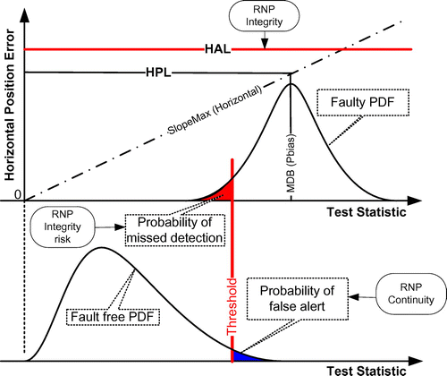
where is the standard deviation of the measurement from ith satellite. Considering the worst case scenario in which the bias occurs on the satellite having the most impact on the PE, the corresponding horizontal protection level (HPL) and vertical protection level (VPL) can be expressed as:
(8)
(9)
where Pbias is the minimum detectable bias determined by the threshold (Tn) in the failure detection test and the PMD. Figure shows the relationships among these parameters. The PFA derived from the RNP’s continuity risk together with the probability density function of the distribution produces the threshold for fault detection. This threshold together with the distribution and the PMD derived from the RNP’s integrity risk provides the Pbias. The Pbias and the slope calculated from the design matrix provide the PL.
Figure 1 Relationships among RAIM parameters.
2.2 Filtering GPS RAIM
The innovation sequence in a Kalman filter provides the most relevant source of information for integrity monitoring. It is similar to the residual in the snapshot RAIM method. The test statistic is constructed as:(10)
where and
are the innovation vector and the weight matrix, respectively, at kth epoch. The scheme to determine the threshold is similar to that for the snapshot RAIM method. However, in this case the DOF is equal to the number of measurements.
The PL can be determined using position uncertainty estimate from the Kalman filter. The elements of the covariance matrix (P) indicate the uncertainty of the state. The first three elements in the state are the position in north-east-down coordinates. Therefore, indicates the horizontal position uncertainty, while
indicates the vertical position uncertainty. The position estimate uncertainty based PL can be expressed as:
(11)
(12)
where kH and kV are factors that reflect the integrity risk in the RNP.
3 Single frequency pseudorange-based dual constellation positioning and RAIM method
One of the major issues in using signals from dual constellations is dealing with the differences between two systems including spatial and temporal reference systems. The spatial reference frame differences can normally be addressed by applying transformation models. Currently, there are three basic methods to deal with system time differences for positioning using multiple constellations.
The first method corrects the GLONASS time by using the broadcast difference relative to GPS time. This is a straightforward method depending on the availability and quality of the broadcast information. The positioning equation can be expressed as:(13)
where
and
,
m is the number of visible GPS satellites and n is the number of visible GLONASS satellites. The subscript R denotes GLONASS and G denotes GPS.
(14)
(15)
A second method takes the time difference between GLONASS and GPS as an unknown within the positioning and timing solution Citation(14). The performance of the estimation depends on the impact of geometry and other errors. The differences compared to the first method are:(16)
(17)
A third method is to perform positioning and integrity monitoring independently in each constellation. In this case, the position solution in each constellation is referred to its own system time. The final solution is achieved as a weighted average of the two solutions Citation(8). However, the positioning error due to system time difference may not be neglected for high dynamic users. Furthermore, the determination of weights for the final solution requires justification. This method was originally proposed for GPS and Galileo with the support of simulated results.
In terms of integrity monitoring, the conventional RAIM methods discussed in Section 2 can be embedded into each positioning method above.
These methods have directly (first two) and indirectly (third) benefited from a better geometry with two constellations. However, they have not exploited other potential benefits of multiple constellations. Due to the similarities of the GNSS systems, there are also spatial and temporal correlations of receiver measurements from different GNSSs. For example, signals coming from similar directions may suffer from the same interference sources due to space and atmospheric disturbance. If the characteristics of interference are not included in the models used in pre-processing, the effect of interference appears as un-modelled and correlated errors.
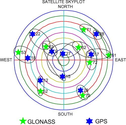
The new method proposed employs a single difference between measurements from two constellations. For example, a difference can be formed between the measurements from one GPS satellite and one or more GLONASS satellites. Clearly, the performance of the positioning solution depends on how these pairs are formed. The approach used to select the basic pairs could make a significant difference in positioning performance. The closeness of satellites from two constellations is used to benefit from the potential correlation of errors in signal propagation; for example, the tropospheric delay Citation(15).
The angle between and
pair can be calculated by:
(18)
where is the dot product.
The total number of pairs that can be formed is . From the geometrical point of view, there are only
independent pairs. However, from the measurement point of view, a small value of
indicates proximity, and therefore higher correlation. Figure demonstrates how the GPS and GLONASS pairs are formed.
Figure 2 An example of GPS and GLONASS pairing.
As long as these pairs are formed, the terms in expression (13) are formed as:(19)
(20)
(21)
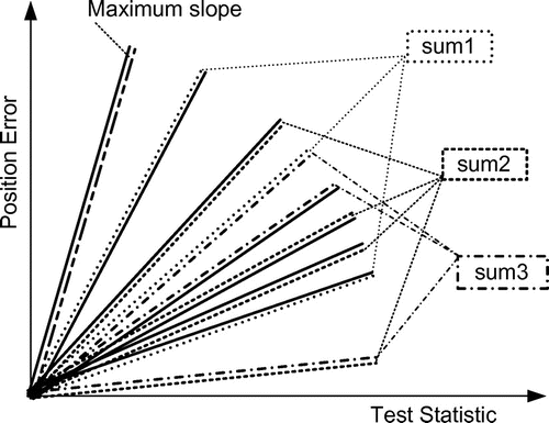
In the single difference mode, it is possible that a failure occurs on a satellite which involves single differences with more than one satellite from another constellation. Consequently, each of the differences containing this “critical” satellite will be faulty. Therefore, the conventional method to calculate the PL is no longer applicable. In this case, even though the multiple failures are caused by one common failure, the impact on PE is multiple. This paper proposes a new way to calculate the maximum slope used for the computation of PL. The method for calculating the basic slopes is similar to expressions (6 and 7). The H and W matrices are replaced with the matrices in single difference mode. If one satellite is involved in a number of single differences, the slopes involving this satellite are summed up. Note that there will be a number of sums since more than one satellite will be used as a reference for single differencing. The maximum values of the sums are compared to the maximum value of basic slopes and the largest one used for the calculation of PL. Figure demonstrates the idea to acquire the final slope for the calculation of PL. Each line pattern in the figure represents a satellite. Therefore, each slope involves two satellites. If one satellite is involved in more than one pair (e.g. the same line pattern), then all the slope values are summed up (e.g. sum 3).
Figure 3 Slopes of single difference geometry.
In a weighted least squares solution, the weight should also reflect the elevation angles or signal to noise ratios of the paired satellites and their proximity.
4 Dual frequency carrier phase-based dual constellation positioning and RAIM method
To achieve high accuracy positioning, the carrier phase measurements must be used. Conventionally, the positioning algorithms need measurements from two receivers with one at a known position (i.e. reference) and with the other one’s position to be determined. A double difference operation of the measurements is carried out to mitigate errors. The degree of correlation depends on the distance between the two receivers known as the baseline. The shorter the baseline, the higher the level of correlation between the measurement errors of the two receivers from same satellite. Most of the measurement errors will be cancelled (e.g. satellite clock error) or mitigated (e.g. ionosphere, troposphere errors) through this differencing process. As a result, the integer cycles known as ambiguities have a greater likelihood to be resolved correctly over short baselines. Subsequently, a high accuracy positioning solution can be achieved. However, the availability of a reference receiver in the vicinity may not always be possible. Traditionally, if measurements from only one receiver are available, the carrier phase measurements are used to smooth the pseudorange measurements in order to achieve relatively higher accuracy.
The main barrier for a receiver to directly use carrier phase as measurements for positioning is that the residual errors are likely to be too big for the carrier phase ambiguity to be resolved. These large residual errors are mainly caused by errors in the broadcast ephemeris and inaccuracy of other error mitigation models. However, the satellite and ionosphere borne errors can be determined accurately from a network of reference receivers. The corrections and associated accuracy for these errors known as products can be transmitted to users for error corrections. In this case, a single receiver can be used to achieve high accuracy positioning by using carrier phase measurements directly. This method is called PPP. Resolving integer ambiguities is the biggest challenge for PPP even with two frequency measurements. The positioning accuracy of GPS-based PPP using a float solution (without ambiguity fixing) is not good enough for applications requiring centimeter level accuracy and the convergence time is too long. For GLONASS, it is even more difficult as the signal generation scheme employs the frequency division multiple access (FDMA) concept.
In PPP with two constellations, the main problems described in Section 3 such as reference system difference are resolved by the products provider. Therefore, it is possible to employ GLONASS to assist GPS for integer ambiguity resolution for PPP. The data pre-processing includes applying corrections from products and models. A number of observations are constructed in order to reach the error budget for ambiguity resolution. The between-satellite-difference operation for carrier phase and pseudorange measurements is used to eliminate the receiver clock error. The narrow lane observation is used in order to achieve a high accuracy solution. Wide-lane observations are also formed to provide the necessary inputs for the narrow lane ambiguity resolution. The integer recoverable clock method is used in narrow lane data processing in order to recover the integer nature of ambiguities from products Citation(16). It is not possible to achieve a positioning solution with measurements from a single epoch since the number of unknown (including ambiguities) is always greater than the number of independent measurements. Therefore, a Kalman filter-based method is employed. It is important to highlight that the quality of products should be taken into account in the measurement (observation) noise matrix.
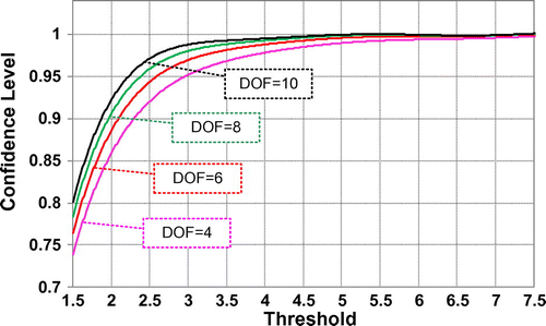
The integrity monitoring is carried out in two stages, ambiguity validation and positioning. The wide lane ambiguity resolution is straightforward and achieved by rounding. The narrow lane ambiguity resolution is based on the well-known LAMBDA method. The ambiguity validation is based on the Ratio test with a defined confidence level. This is achieved by using the doubly non-central F distribution method Citation(17) for the determination of a variable threshold for the Ratio test. Instead of online calculation, an offline look-up table is used. The relationships among confidence level, threshold, and DOF are shown in Figure . If the ratio test cannot achieve the required confidence level, the estimated ambiguity is not accepted. This is to avoid any potential incorrect ambiguities contaminating the positioning solution.
Figure 4 The relationship between confidence level and threshold for various DOFs.
At the positioning stage, failure detection is similar to expression (10) because the Kalman filtering method is used. The PL calculation needs to take into account not only the resulting errors due to the combination of measurements but the potential for missed detection. For the PPP algorithm, the positioning error is more sensitive to measurement errors than in pseudorange only positioning. A minor bias in the pseudorange only based positioning can be overbounded by the standard deviation of pseudorange measurements. However, a minor bias in carrier phase measurements may not be overbounded by its standard deviation due to low carrier phase noise. It is not reasonable to intentionally increase the standard deviation of carrier phase measurements in order to overbound a potential bias. Overbounding compromises the positioning accuracy. To deal with this issue, the slope concept for snapshot RAIM is adopted as:(22)
(23)
where K is the gain matrix in the Kalman filter and (24)
(25)
where T is the threshold for fault detection and and
are factors that reflect the integrity risk in the RNP.
5 Results
5.1 Single frequency pseudorange-based Positioning and RAIM
In order to compare the performance of the single difference-based dual constellations RAIM algorithm proposed, the positioning solutions for four scenarios were generated. The four scenarios are:
GPS only;
GLONASS only;
GPS + GLONASS taking system time difference as unknown for estimation (GRT in figures);
Cross constellation single difference.
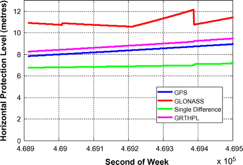
Figures show the horizontal positioning error and HPL for ZIM2 on 25 February 2012. Figure shows that the single difference solutions have the lowest horizontal errors. Figure shows that the PL for the single difference solution is the lowest.
Figure 5 Horizontal errors at ZIM2 on 25 February 2012.
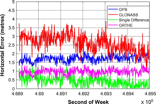
Figure 6 HPLs at ZIM2 on 25 February 2012.
Figures demonstrate the performance of the proposed dual constellation RAIM algorithm for this case study. Obviously, the performance depends on the availability of the pairings formed from expression (18). Obviously, with multiple constellations, there will be more satellites that can be used to reach an optimal pairing scheme.
5.2 Dual frequency carrier phase based positioning and RAIM
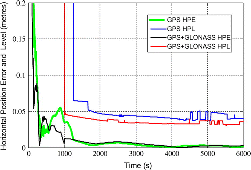
The satellite orbit and clock corrections are provided by CNES. The C1-P1 and C2-P2 differential code bias correction are provided by the center for orbit determination in Europe. The ionosphere-free combination is used to eliminate the first-order effects for both carrier and pseudorange measurements. The other corrections applied include cycle slips detection and repair, satellite/receiver antenna phase center offsets, and variations, satellite phase-windup, site displacement, and solid earth tides Citation(16). Figure shows the horizontal errors and HPLs for GPS only and combined GPS and GLONASS PPP. It can be seen in the figure that the GPS HPL (blue) always bounds the horizontal PE (green). The HPL (red) of combined GPS and GLONASS always bounds the horizontal PE (black). The GPS integer ambiguities of the combined GPS and GLONASS algorithm were resolved and validated at about 1000 s, while the GPS only case took about 200 s more. The HPL (red) of the combined GPS and GLONASS is always smaller than that of the GPS only (blue). However, there is little difference in the horizontal PE after the fixing of the GPS integer ambiguities in this case because there were enough GPS satellites (eight) used. With a limited number of GPS satellites in view, a longer time is expected for the GPS only case to resolve ambiguities.
Figure 7 HPEs and HPLs at UNB3 on 2 January 2012.
The benefit of GLONASS assisting GPS for PPP is that it can reduce the time needed to resolve and validate the GPS ambiguities. Due to the signal characteristics of FDMA and the quality of GLONASS products, the feasibility of resolving GLONASS integer ambiguities still needs more investigation. However, with the future code division multiple access (CDMA) systems, it will be possible to resolve and validate ambiguities for multiple constellations.
6 Conclusions
This paper has presented the challenges and benefits of the use of existing dual constellations GPS and GLONASS for positioning and integrity monitoring. Depending on the type of measurements, data processing schemes, and positioning algorithms, there are many potential combinations. Two representative methods are presented to demonstrate the positioning and integrity monitoring for dual constellations, the basic single frequency pseudorange, and the more difficult dual frequency carrier ambiguity fixed PPP. With the basic dual constellations method, the positioning algorithm benefits from the similarity of the dual systems while minimizes the impact of differences by forming cross constellation satellites pairs. The differencing eliminates receiver clock error and mitigates any correlated errors between a pair. A corresponding RAIM algorithm is developed to take into account the pairing. The results with real data have demonstrated the feasibility and good performance of the single difference-based dual constellations positioning and RAIM. It can be extended to multiple constellations. Due to the simplicity and high performance of the method, it is suitable for mass market receivers using dual or multiple GNSS constellations.
PPP employs various products generated from a network of reference receivers. The differences between two GNSSs can easily be determined and compensated by the product providers. To address the remaining issues, data combination schemes are employed to compute and validate the integer ambiguities. GLONASS is used to assist the resolution of GPS ambiguities. PPP with both GPS and GLONASS real data have demonstrated the benefit of GLONASS in reducing the time needed to resolve and validate GPS integer ambiguities. The PL for dual constellations PPP was found to always bound the PE. Even though GLONASS can enhance the positioning accuracy when a limited number of GPS satellite is visible, its contribution to positioning accuracy is very little when the GPS integer ambiguities are fixed. These dual constellations positioning and integrity monitoring algorithms have the potential to be extended to multiple constellations. With Galileo or modernized GLONASS, it should be possible to resolve and validate ambiguities for both constellations resulting in a more accurate positioning solution and better integrity mentoring performance.
Notes on contributors
Shaojun Feng is a research fellow at the Centre for Transport Studies within the Department of Civil and Environmental Engineering at Imperial College, London. He leads the navigation research team within the Imperial College Engineering Geomatics Group (ICEGG). He is a fellow of the Royal Institute of Navigation and a member of the US Institute of Navigation.
Altti Jokinen is a PhD student at the Centre for Transport Studies within the Department of Civil and Environmental Engineering at Imperial College, London.
Carl Milner is an assistant professor at École Nationale de l’Aviation Civile, Toulouse France.
Washington Ochieng holds the chair in Positioning and Navigation Systems in the Department of Civil and Environmental Engineering at Imperial College, London. He is the head of the Centre for Transport Studies and director of the ICEGG. He is a chartered engineer and Fellow of the Royal Academy of Engineering, the Institution of Civil Engineers, the Chartered Institution of Highways and Transportation, and the Royal Institute of Navigation. He is a member of the US Institute of Navigation.
Acknowledgments
This research was carried out within iNsight (www.insight-gnss.org), a collaborative research project funded by the UK’s Engineering and Physical Sciences Research Council (EPSRC), to extend the applications and improve the efficiency of positioning through the exploitation of new global navigation satellite systems signals. It is being undertaken by a consortium of 12 UK university and industrial groups: Imperial College London, University College London, the University of Nottingham, the University of Westminster, the EADS Astrium, Nottingham Scientific Ltd, Leica Geosystems, the Ordnance Survey of Great Britain, QinetiQ, STMicroelectronics, Thales Research and Technology UK Limited, and the UK Civil Aviation Authority.
References
- DoD. Global Positioning System (GPS) Standard Positioning Service Performance Standard; Department of Defence: Washington, DC, 2008.
- ICAO. International Standards and Recommended Practices, Annex 10, Radio and Navigation Aids; International Civil Aviation Organization: Montréal, 2006; Vol. 1.
- Ochieng, W.; Sauer, K.; Walsh, D.; Brodin, G.; Griffin, S.; Denney, M. GPS Integrity and Potential Impact on Aviation Safety. J. Navig. 2013, 56 (1), 51–65.
- RTCA. DO-208: Minimum Operation Performance Standards for Airborne Supplemental Navigation Equipment Using Global Positioning System (GPS); RTCA: Washington, DC, 1991.
- Feng, S.; Ochieng, W.; Moore, T.; Hill, C.; Hide, C. Carrier-Phase Based Integrity Monitoring For High Accuracy Positioning. GPS Solutions 2009, 13 (1), 13–22.
- Blanch, J.; Ene, A.; Walter, T.; Enge, P. In An Optimized Multiple Solution Separation RAIM Algorithm for Vertical Guidance, Proceedings of the ION GNSS 2007, Fort Worth, TX, Sept, 2007, pp. 2924–2933.
- GEAS. Phase II of the GNSS Evolutionary Architecture Study, February 2010.
- Lee, Y.C.; McLaughlin M.P. In Feasibility Analysis of RAIM to Provide LPV-200 Approaches with Future GPS, Proceedings of the 20th International Technical Meeting of the Satellite Division of The Institute of Navigation, Fort Worth, TX, Sept, 2007, p. 2528.
- Brown, R.G. In Receiver Autonomous Integrity Monitoring. Global Positioning System: Theory and Applications; Bradford, W., Parkinson, James J., Spilker, Jr., Eds.; American Institute of Aeronautics and Astronautics: Washington, DC, 1996; Vol. 2, pp. 143–165.
- Brown, R.G. A Baseline GPS RAIM Scheme and a Note on the Equivalence of Three RAIM Methods. Navig.: J. Inst. Navig. 1992, 39 (3), 301–316.
- Feng, S.; Ochieng, W.; Walsh, D.; Ioannides, R. A Measurement Domain Receiver Autonomous Integrity Monitoring Algorithm. GPS Solutions 2006, 10 (2), 85–96.
- Walter, T; Enge, P. In Weighted RAIM for Precision Approach, Proceedings of the 1995 National Technical Meeting of The Institute of Navigation, Anaheim, CA, Jan, 1995, p. 1820.
- Feng, S.; Ochieng, W. A Dynamic Sampling Scheme for GPS Integrity Assessment. Aeronaut. J. 2006, 110 (1105), 129–143.
- Cai, C.; Gao, Y. A Combined GPS/GLONASS Navigation Algorithm for use with Limited Satellite Visibility. J. Navig. 2009, 62, 671–685.
- Feng, S.; Milner, C., Jokinen, A.; Ochieng, W.; Hide, C.; Moore, T.; Hill C.; Ziebart M.; Bahrami M.; Groves P.; Jiang Z. In A Novel Positioning and Integrity Monitoring Algorithm for a Multiple Constellation Receiver, Proceeding of the ION GNSS, Portland, OR, Sept, 2011, p. 1923.
- Jokinen, A.; Feng, S.; Milner, C.; Schuster, W.; Ochieng, W.; Hide, C.; Moore, T; Hill, C. In Fixed ambiguity Precise Point Positioning (PPP) with FDE RAIM, Proceeding of the IEEE/ION The Position Location and Navigation System (PLANS) Conference, Myrtle Beach, SC, Apr, 2012; p. 2426.
- Feng, S.; Ochieng, W.; Samson, J.; Tossaint, M; Hernandez-Pajares, M. Integrity Monitoring for Carrier Phase Ambiguities. J. Navig. 2012, 65 1, p. 41–58.