Abstract
The science of geomorphology works on natural 3D landforms. Research includes the change of landforms as well as the processes causing these changes. Material transport processes lead to a composition of a geomorphic system that follows a certain spatial hierarchy. The analysis of 3D topological relations of landforms can help to investigate geomorphic systems in two ways. First, chronological order of geomorphic genesis can be derived and, second, indications of material source can be found. However, at least some 3D geometric information is needed if topology is supposed to be derived and examined. Landforms cannot simply be reconstructed by surface measurements. Data capture is a major problem when buried features are under investigation. Subsurface information is gathered by drillings or geophysical methods that reveal point or line information. Unfortunately, the ISO 19107 Spatial Schema does not offer a valid representation of 3D geometry from sparse data, either by aggregating a surface and one or few points or by aggregating a surface and a line. Here, we discuss the possibilities for the analysis of chronological order of landform genesis and material dependencies that arise from applying 3D topological relationships to geomorphic system analysis. We show five relationships that are able to be observed in nature. Further, we introduce a new class for the representation of 3D objects with under-specified geometry. A _UG_Solid mediates between the Spatial Schema’s geometric primitives with a dimension less than three on the one side and a GM_Solid on the other side. Constraints to aggregate such a _UG_Solid are defined. The introduction of a _UG_Solid facilitates the application of 3D topological concepts to geometric objects that are known to be volumetric but have to be modeled from sparse data.
1. Introduction
Geomorphology defines itself as the science of natural landforms (Citation1, Citation2). Objects of research include geometric aspects of a 2.5D land surface that are covered by the science of geomorphometry (Citation3, Citation4) and change of landforms as well as processes causing these changes. In general, landforms can be described as units of material, the sediment, that is accumulated under specific conditions and are reworked first, by external, mainly material transport processes and, second, by internal processes like weathering. Results of such changes express themselves in shape, material properties, and resistance to external forces. Outcrops of these landforms compose the 2.5D boundary surface between solid earth and the atmosphere or the hydrosphere, respectively.
Climate and gravity are the main external forces of such material transport processes (e.g. soil erosion and corresponding accumulation or mass movements). In the first place, running water erodes and transports material from one landform and accumulates it on the top of another one. The eroding power of flowing water is determined by the surface (e.g. slope) and the material’s resistance. Internal properties (e.g. soil texture or bulk density) determine the effectiveness of gravity causing mass movements like rock fall or debris flows (Citation5), also. The latter is definitely a property of a three-dimensional body holding the sediment of a landform.
Therefore, in geomorphology, the surface under consideration is a three-dimensional body divided into neighboring landforms. This fact is expressed in the broadly accepted term georelief coined by the German scientists Kugler (Citation6) and Dikau (Citation7). First, it represents the visible and measurable boundary surface between land surface and atmosphere or hydrosphere and, second, the material of which this surface is composed (Citation8). In geomorphology, this recognition of the land surface results in a triad of process, material, and form. These three variables are characterized by strong feedbacks which have to be resolved when describing a geomorphic system.
An important aspect of landform system analysis is the concept of topology as it helps to describe and analyze the spatial distribution of landforms. Topological concepts may be applied to first, represent the pathway of sediment that is transported through a geomorphic system using a graph-based approach and, second, to describe the spatial distribution of landforms using 3D topological relationships. A consistent data model could support research on geometric and semantic modeling as well as on topological analysis of landform systems.
As a starting point, the Open Geospatial Consortium’s Abstract Specifications (Citation9) enable such a modeling of real-world phenomena to represent them as formal information models (Citation10). These information models may include geometry, attributes, and topological relationships of real-world objects. The main advantage of internationally accepted standards like OGC’s Abstract Specification is interoperability. That means the seamless exchange of data, first, between researchers of a scientific discipline, normally working all over the world and, second, between researchers of a scientific discipline and GIS specialists. The latter enables researchers to take part in the progress achieved in spatial information science. A further advantage is direct access to standardized tools for database implementation.
The main document presenting the Abstract Specification is the ISO 19107 ‘Spatial Schema’ (Citation10) defining geometric primitives and complexes from 0D to 3D according to the boundary representation (Citation11). Along with other concepts, it is implemented in the Geography Markup Language (GML) (Citation12). The Spatial Schema provides a topology package, mainly to convert computational geometry algorithms into combinatorial ones (Citation10). Topological primitives (i.e. nodes, edges, faces, and solids) do not need realizations in the form of well-modeled geometric primitives of the same dimension. However, even if 3D topology can be applied and may support the analysis of the features under investigation, valid 3D geometry would even support this investigation.
3D reconstruction of landforms, however, is made difficult. Whereas the landsurface is easy to reconstruct, prospection methods for buried features are limited. Often, only points or lines of underground boundary surfaces can be prospected. There is no representation that allows the creation of a solid from this sparse data in Spatial Schema.
Here, we discuss the possibilities for the analysis of chronological order of landform genesis and material dependencies that arise from applying 3D topological relationships. Further, we propose a new class for the representation of 3D objects with under-specified geometry. _UG_Solid mediates between the Spatial Schema’s geometric primitives with a dimension less than three on the one side and a GM_Solid on the other side. Constraints to aggregate a _UG_Solid are defined. The introduction of a _UG_Solid facilitates the application of 3D topological concepts to geometric objects that are known to be volumetric but have to be modeled from sparse data.
In the next section, the topological aspects of landforms are discussed with respect to graph-based approaches (Section 2.1) and new considerations about 3D topological relations of landforms. Special cases of topological relationships between 3D solids are directly related to geomorphic insights (Section 2.2). In the following section, problems of data acquisition and modeling are outlined (Section 3.1). Section 3.2 continues with a new approach to represent under-specified 3D geometry within the Spatial Schema to link 3D topology to under-specified geometries. Section 5 follows up with a conclusion.
2. Topological aspects of landforms
Landforms do not exist in isolation, but do interact with others. Their specific association builds up the georelief (Citation6) and characterizes a specific geomorphic system. Because single landforms are scale-dependent, the composition of a geomorphic system follows a spatial hierarchy (Citation14, Citation15). Smaller landforms are located on the tops of larger ones and partly cover them. Therefore, size is a good indicator of a landform’s lifetime and age (Citation16).
Like a single landform, the association of many depends on internal system states and external driving forces and, therefore, material remobilization and transport processes. Following this experience, analyzing the composition of landform associations allows scientists to understand the main processes reworking a system and, further, the succession of these processes in the past and probable developments in the future.
According to Dikau (Citation17), investigation of landforms includes first, time represented by the stratigraphic record of the underground material and, second, the spatial distribution of landforms. The latter clearly refers to a topological description of landforms that may help to compare different natural systems. This landform assemblage has also been identified by (Citation15) as an important character of geomorphic systems.
Topological concepts may support the analysis of geomorphic systems in two ways. The first is the identification of features that are connected via material transport processes. Landforms may be described as knots that are connected by edges representing existing or past material exchange (rf. Section 2.1). The second is the representation of topological relations between landforms or parts of them that are 3D bodies in the 3D space. This may enable analysis of chronological order of landform genesis and material dependencies (rf. Section 2.2). The latter is a new point and is able to support the analysis of natural landforms and geomorphic systems.
2.1. Graph-based representation of landforms and geomorphic systems
A lot of interaction between landforms may be described by directed graphs. Applying 2D topology, processes transporting material from one landform to another one can be represented. Identifying possible material sources is the first step to expose and explain cascading sediment movement within geomorphic systems. The resulting graph would be a digraph representing the direction of sediment flux.
The concept of a sediment cascade is one of the main concepts in geomorphology (Citation19, Citation20). In theory, sediment is captured in storages for a certain period of time. Storage period depends on eroding processes, their force and, of course, the sediment’s internal resistance to these processes. In terms of system theory (Citation21), the output of one storage acts as the input for another one. Regulators like slope decide whether eroded material remains on the landform or is being transported to one or many others.
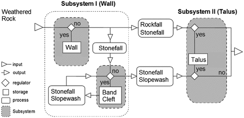
One example of a sediment cascade is the interaction of a free face, i.e. a wall, with an underlying talus slope (Figure ). As the main storage, the wall feeds the talus slope by stone fall. The talus slope is situated at the wall’s foot and is built up of the waste products of the wall. Nevertheless, the same process could accumulate the material on smaller features sitting on the wall itself, i.e. a band or a cleft. Whereas a band is a step-like feature, a cleft is a crack that is a characteristic feature of many rock walls. Both are able to store the material. Due to the formalism used in geomorphology, no geometric properties or time spans are represented.
Figure 1. Sediment cascade of the two subsystems Wall and Talus. Following the notation of system theory (Citation21), no geometry and time is represented (from Ref. (Citation22)).
Based on Spatial Schema (Citation10), Löwner (Citation23) proposed a GML-based application model that is able to represent the concept of a sediment cascade, first, in terms of landforms with 3D geometry and, second, the processes that link them by material exchange. Herein, an abstract class _Geoobject represents a solid landform feature as a particular spatial unit of the landsurface. The class has one or more associations to an abstract class _State. For an associated Timespan, the _State acts as an agent between the _Geoobject and its properties including geometry and attributes. The latter is modeled by an abstract class _AttributeSet.
Landforms are subject to change due to external forces resulting in material transporting processes. This fact is modeled introducing an abstract class _Geoprocess that may connect two instances of a _Geoobject initializing new instances of the corresponding _States (Figure ).
Figure 2. The abstract class _Geoprocess, altering, i.e. creating new instances of the class _State. (modified, see Ref. (Citation23).
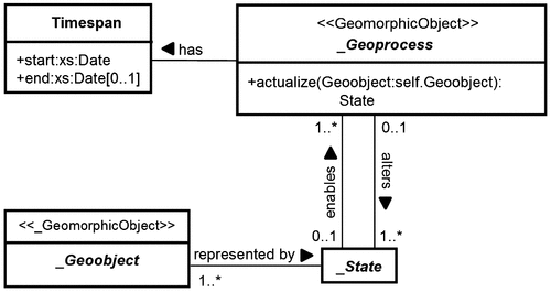
Thus, the concept of a _Geoprocess can be considered as a connecting edge between two landforms that is valid for a given time span. Therefore, a graph representing the movement of the material, i.e. sediment, can be implemented in a spatial database.
The formally modeled interrelationship between landforms and processes directly enables a graph-like representation of a sediment cascade. The landform acting as a sediment source may then be interpreted as the “from-node” and the other, acting as a sink, as the “to-node”.
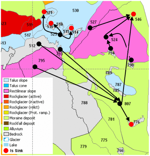
Löwner and Otto (Citation24) applied a topological representation of a sediment cascade on the basis of the dual graph concept (Citation25). The origin planar graph was given by a geomorphic map representing the landforms. However, some edges joining two neighboring regions were eliminated from the dual graph, applying geometric analyses to ensure the representation of down slope material movement (Figure ). However, this 2D digraph representation only represents a current possible way the material is moved by processes, today.
Figure 3. Representation of a sediment cascade in 2D. Sediment sources are interpreted as the “from-node” and sinks as the “to-node”.
Löwner and Becker (Citation26) propose a framework for 4D landform representation that simplifies the complex spatial relationships between 3D objects and the modeling of geological processes over time applying the Poincaré Duality to build up a multilayered graph. Solid 3D objects in primal space, e.g. horizons of a landform, are mapped to vertices in dual space. The common 2D face shared by two solid objects is transformed into an edge linking two vertices in dual space. Thus, edges of the dual graph represent adjacency and connectivity relationships in primal space (Citation27). The resulting graph represents a whole landform of stable conditions over a period of time. Change of a landform is represented as additional edges between the nodes of stable time periods. All dual representations may be associated with geometric and semantic representations, if available.
2.2. 3D topological relationships of landforms
Landforms are and consist of volumetric sediment bodies that are regularly arranged. Younger landforms normally lie above older ones. Eroding processes may have cut into landforms leaving hollows for new material coming from adjacent landforms or even landforms that are far away. Again, these fillings form new landforms. Following this experience, analyzing the composition of landform associations is an important step towards landform interpretation.
Next to graph-based representation, 3D topological relationships are able to describe the specific association of landforms and their parts. Here, we show that a representation using 3D topological relationships could even help to identify the chronological order in which landforms were formed. Often, this non-metric or relative dating is an important step towards the understanding of a geomorphic system.
Based on Egenhofer’s 9-intersection model (Citation28, Citation29), Zlatanova (Citation30) presented an integrated study on possible topological relationships between multidimensional simple objects in 0, 1, 2, and 3D space and identified 48 relationships of 0D–3D geometries in ℝ3 that are possible in reality. This includes 8 relationships of bodies in ℝ3 that are equal to the topological relationships between two spatial regions defined by Ref. (Citation31) and to which we restrict ourselves here. Characterization is performed assuming two simple spatial objects, a and b, that are defined in ℝ3. Their boundary, interior and exterior are denoted by ∂a, a°, and a−; and ∂b, b°, and b−, respectively. The topological relationship R(a,b) between the two objects is then identified by composing the possible set of intersections (∂a ∩ ∂b, a°∩ b°, ∂a ∩ b°, a°∩ ∂b, a− ∩ b−, a− ∩ ∂b, a− ∩ b°, ∂a ∩ b−, and a°∩ b−) resulting in a 9-bit binary value. For example, if two objects have a common boundary, the intersection between the boundaries is non-empty, i.e. ∂a ∩ ∂b = −Ø. The binary value is then converted into a decimal number, e.g. R287 for ‘a meets b’, where intersections ∂a ∩ ∂b, a− ∩ b−, a− ∩ ∂b, a− ∩ b°, ∂a ∩ b−, and a°∩ b− = ¬Ø (Citation32).
Not all of the identified topological relations that are possible in reality are of interest, when landforms are considered. Here, we discuss four of them that are of relevance and that can be found in geomorphic systems. These are coveredBy, meet, disjoint, and inside. However, a fifth relation incorporating a third body is discussed further down.
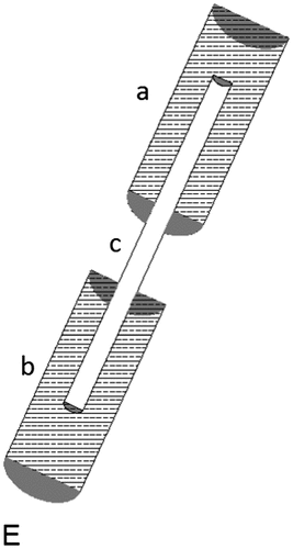
Figure depicts four topological relationships of landforms that are explained in Table . Whereas the topological relationship of 4B and 4C could be described with 2D concepts, 4A and 4D need a 3D topological representation. However, the relationship depicted in E (Figure ) considers a third connecting landform.
Figure 4. 3D topological relationships of two landforms within a geomorphic system (rf. Table
Table 1. Geomorphic description of topological relationships of landforms (rf. Figure ).
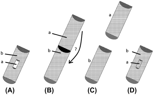
Table 2. Geomorphic description of topological relationships of three landforms (rf. Figure ).
Figure 5. 3D topological relationships of three landforms within a geomorphic system (rf. Table ).
The examples described in Figure and Table can be observed in nature. Figure (A) shows a common situation on loess covered hillslopes that were linearly eroded during strong storm events. The resulting hollow is then filled by sheet erosion, afterwards (Citation33, Citation34). Figures (B) and (C) depict common situations of landform alignment. In Figure (D), piping or tunnel gullies has been identified as an important process (Citation35, Citation36). In many instances, collapsed pipes form gullies, and in some cases may even become filled with colluvially derived sediments.
Another 3D relationship of landforms is depicted in Figure . Here, three bodies are involved from which two are disjoint but connected via a third landform. The latter could be a formerly channel that was filled by accumulation. This example is directly related to the graph-based approach in Section 2.1.
3. Linking 3D topology to under-specified geometries
Geomorphology investigates the history of landforms. The analysis of 3D topological relations of landforms can help to investigate geomorphic systems. First, chronological order can be derived and, second, indications of material source can be found. However, at least some 3D geometric information is needed if topology is supposed to be derived and examined. Next to the visible surface, the subsurface boundary surfaces and material properties are of interest. The subsurface boundary surface represents the paleo-surface, building the starting conditions of the landform under investigation and therefore an important jigsaw piece when throwing light on the landform’s genesis.
Although much is known about processes and their interactions with the land surface, reconstruction of the subsurface is still a major problem. In addition, subsurface boundaries of landforms are developed under different and partly unknown (i.e. regional climate) conditions. Therefore, it is not predictable that they vary in the same manner as the land surface today.
In the following, we briefly outline problems of data acquisition and modeling (Section 3.1) and continue with a new approach to represent under-specified 3D geometry within the Spatial Schema (Section 3.2).
3.1. General problems of data acquisition and modeling
Compared to landforms, feature geometry of our man-made environment can be modeled much more easily. Take CityGML’s Level of Detail 1 building model as an example (Citation37). Usually a polygon representing the ground surface and the height of the building is used to create a valid 3D solid that represents a building (rf. Figure ). Even an LOD2 model is generated by adding a few more planar surfaces to represent the building’s roof structure. Today, at least 2D digital information about infrastructure is easily available. Additional 3D data-sets are available by LIDAR technologies (Citation38).
Figure 6. Differences in the geometric modeling of (a) a natural (buried) feature and (b) a CityGML’s LoD1 building model.
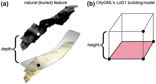
Landforms cannot simply be reconstructed this way. Extruding a planar 2D-polygon or rolling surface to represent a landform’s subsurface boundary by measured feature depth would neglect the vital role of the paleo-surface. Further, simply copying the digital elevation field of the land surface to the measured depth would also be inadmissible. Since landforms are the result of partly unknown material transport processes acting over a long time on unclear boundary conditions, it is not recommendable to derive subsurface boundaries from today’s land surface.
Data capture may be identified to explain the significant differences between modeling approaches representing man-made structures and landforms, respectively (Citation39). Capturing a buried feature is much more difficult than measuring a construction above the surface. Normally, subsurface information is gathered by drillings. Boundary surfaces are identified via abrupt changes in sediment properties. These are for example grain size or distribution, density, color, or biochemical indicators. Often geophysical methods are applied to get subsurface information (Citation34, Citation40, Citation41). Depending on the method used, geophysical devices reveal changes in density, electronic conductivity, and others. These changes are to be interpreted as boundary surfaces of the landform.
In geomorphology, there are two ways to overcome the problems of valid geometric modeling. First, data is stored using the layer principle (Citation42, Citation43). Second, data is just represented in form of text, graphics, and (not database) tables. As a result, research on landforms may not profit from further developments of the GI community in terms of data exchange or geometrical and topological representation and analysis.
Unfortunately, the ISO 19107 Spatial Schema does not offer a valid representation of 3D geometry, either by aggregating a surface and one or few points or by aggregating a surface and a line. Consequently, even if the nature of a feature is proved to be three dimensional, Spatial Schema seems to be inadequate for representing under-specified 3D geometries. This directly affects the possibility of applying a topological representation.
3.2. A class for under-specified 3D geometries
Many concepts of geomorphology describe 3D phenomena. Therefore, a 3D application model for the representation of geometry is highly desirable. Additionally, 3D topological relationships of landforms directly reflect geomorphic principles like mass exchange and chronological order. Even though analysis can still be performed on 3D topological solids, a proper 3D geometry representation would support this analysis.
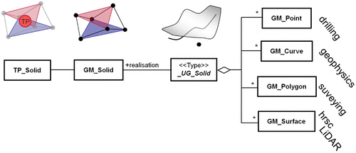
Here, we present a simple approach to use the benefits of valid 3D topology and to link it to geometry, even if only sparse data is available. Therefore, an abstract class _UG_Solid is introduced to represent an under-specified 3D geometry, where UG may be read as Under-specified Geometry. Every object should be modeled as an under-specified 3D geometry that is a 3D object for knowledge reasons but not well defined for geometric reasons. The class _UG_Solid is modeled to aggregate geometric data of different dimensions lower than three, which can be used to reconstruct a 3D geometric volume if some conditions are fulfilled (see below). However, this 3D geometric volume does not represent the real geometry of the object. Following clearly defined conditions, a _UG_Solid mediates between the GM_Primitives GM_Point, GM_Curve, GM_Surface, the type GM_Polygon, and a GM_Solid. Then, this GM_Solid is the realization of a _UG_Solid that holds the 3D geometry we need to associate with the TP_Solid (Figure ).
Figure 7. Aggregation of different GM_Primitives to a _UG_Solid.
Whereas the realization of a _UG_Solid, the GM_Solid class needs to be a real 3D geometry, constraints have to be defined for aggregating a _UG_Solid.
In topology, the geometric characteristics are not important, except for dimension. Thus, constraints on the association multiplicity only need to make sure that a real solid could be modeled from existing data. Of course, this solid must be closed.
Assuming a 2- or 2.5-dimensional (main) surface with an additional geometry representing the depth of a geomorphic feature this constraint can be formulated as Formula (Equation1(1) ):
(1)
where dimMS = dimension of the geometry representing the main surface (e.g. 0 for a point); numMS = minimum number of geometries to represent the main surface (e.g. 3 points); dimDI = dimension of geometry representing the depth information (e.g. 1 for a line); and numDI = minimum number of geometries to represent the depth information (e.g. 1 point).
Table gives examples of typical data available by prospection methods. It can be shown that the given data is sufficient to realize a 3D geometry needed to apply 3D topology. Testing the aggregating geometries against Formula (Equation1(1) ) enables a valid realization that is needed to build a GM_Solid. The realization itself is a matter of implementation and needs further discussion.
Table 3. Possible combinations of simple geometries to form a _UG_Solid.
4. Conclusions
We discussed five 3D topological relationships between landforms that can be found in nature. Analyzing the 3D topological relationships of landforms may provide insights of the geomorphic system under investigation. These include reasonable assumption about the chronological order of landform genesis and material origin. Under the assumption that 3D topological relations are available, planning of field campaigns to investigate the system could considerably be facilitated.
3D topological relationships have hardly been recognized in geosciences until today. However, there has been a great deal of research in the fields of GIS and database management and queering. Applying 3D concepts to landform system analysis would considerable support geoscience. This includes comparison of different geomorphic systems, also. A problem may arise when modeling the framework of topological relationships according to the ISO 19107. Since every geometric instance is allowed to have only one topological representation, it cannot be represented next to the Poincaré Duality, representing a sediment cascade.
However, another important obstacle to the representation of natural landforms can be identified if one looks at Spatial Schema. Today, it does not allow for the representation of 3D volumes that have to be reconstructed from sparse data. Especially in geosciences data-poor situations are normal due to the nature of buried landforms. This suggests that Spatial Schema is only suitable to support 3D geometry representation of man-made features.
Here, a simple approach to represent 3D geometry from sparse data linking several geometries with dimensions less than three to a GM_Solid using the newly introduced class _UG_Solid has been proposed. Nevertheless, the approach presented is incomplete. First, this must be said in terms of dimensions, since 0D-2D under-specified geometries are not covered. Second, no relationships between the GM_Primitives have been modeled. This is surely a worthwhile focus for future research.
Notes on contributors
Marc-O. Löwner is an associate professor at the Technische Universität of Braunschweig. He studied physical geography at the University of Bonn and did his PhD on semantic modeling of geomorphic objects. As a co-developer of the OGC Standard CityGML, he is further interested in virtual 3D city models and its application.
References
- Chorley, R.J.; Schumm, S.A.; Sudgen, D.E.; Geomorphology; Methuen: London, 1984.
- Hugget, R.J. Fundamentals of Geomorphology; Routledge: London, 2003.
- Evans, I.S. General Geomorphometry, Derivates of Altitude, and Descriptive Statistics. In Spatial Analysis in Geomorphology; Chorley, R.J., Ed.; Methuen: London, 1972; pp 17–90.
- Rasemann, S. Geomorphometrische Struktur eines mesoskaligen alpinen Geosystems [Geomorphometric Structure of an Meso-scale Alpine Geosystem]. Bonner Geographische Abhandlungen. 2004, 111, 240.
- Summerfield, M.A. Global Geomorphology – An Introduction to the Study of Landforms; Addison Wesley Longman: Essex, 1997.
- Kugler, H. Das Georelief und seine kartographische Modellierung [The Georelief and its Cartographic Modelling]. Dissertation B, Martin-Luther-Universität Halle, Halle, 1974.
- Dikau, R. Geomorphologische Reliefklassifikation und -analyse [Geomorphologic Relief Classification and Analysis]. Heidelberger Geographische Arbeiten 1996, 104, 15–23.
- Young, A. Slopes; Longman: London, 1978.
- Open Geospatial Consortium. Abstract Specifications. http://www.opengeospatial.org/standards/as. (accessed Nov 6, 2013).
- Kottman, C.; Reed, C. The OpenGIS® Abstract Specification Topic 5: Features, OGC Document 08-126, 2009
- Herring, J. The OpenGIS abstract specification, Topic 1: Feature Geometry (ISO 19107 Spatial Schema), Version 5. OGC Document 01-101, 2001.
- Requicha, A.A.G. Representation for Rigid Solids: Theory. Methods and Systems. ACM Computing Surveys. 1980, 12, 437–464.
- Lake, R.; Burggraf, D.S.; Trininic, M.; Rae, L. GML – Geography Mark-Up Language; Wiley: Chichester, 2004.
- Ahnert, F. Modelling Landform Change. In Modelling Geomorphological Systems: Anderson, M.G., Ed.; John Wiley & Sons: Chichester, 1988; pp 375–400.
- Dikau, R. The Application of a Digital Relief Model to Landform Analysis in Geomorphology. In Three Dimensional Applications in Geographic Information Systems: Raper, J., Ed.; Taylor & Francis: London, 1989; pp 51–77.
- Brunsden, D. Geomorphological Events and Landform Change. Z. Geomorph. N. F. Suppl.-Bd. 1996, 40, 273–288.
- Ahnert, F. Einführung in die Geomorphologie [Introduction to Geomorphology]; Eugen Ulmer: Stuttgart, 1996.
- Dikau, R. The need for field evidence in modelling landform evolution. In Process Modelling and Landform Evolution, Lecture Notes in Earth Sciences; Hergarten, S., Neugebauer, H., Eds., Vol. 78, 1999; pp 3–12.
- Pike, R.; Dikau, R. Advances in Geomorphometry. Z. Geomorph., N.F., Suppl.-Bd. 1995, 101, Stuttgart,
- Church, M.; Slaymaker, O. Disequilibrium of Holocene sediment yield in Glaciated British Columbia. Nature 1989, 337, 452–454.
- Jordan, P.; Slaymaker, O. Holocene sediment production in Lillooet River Basin British Columbia: A sediment budget approach. Géographie physique et Quaternaire. 1991, 45, 45–57.
- Chorley, R.J.; Kennedy, B.A. Physical Geography - A System Approach; London, 1971.
- Löwner, M.-O. Formale semantische Modellierung von geomorphologischen Objekten und Prozessen des Hochgebirges zur Repräsentation in einem Geoinformationssystem (GIS) [Formal Semantically Modelling of Geomorphic Objects and Processes in Alpine Areas for the Representation within a Geo Information System (GIS)]. Bonner Geographische Abhandlungen 2008, 122, 120.
- Löwner, M.-O. New GML-based Application Schema for Landforms, Processes and their Interaction. In Landform – Structure, Evolution, Process Control. Lecture Notes in Earth Sciences: Otto, J.-C., Dikau, R., Eds., Vol. 115, 2010; pp 21–36.
- Löwner, M.-O.; Otto, J.-C. Towards an Automatic Identification of Sediment Cascades from Geomorphological Maps Using Graph Theory. In Proceedings of the International Symposium on ‘Sediment dynamics in changing environments’, Christchurch, New Zealand, Dec 1–5, 2008.
- Diestel, R. Graph Theory; Springer: New York, 1997.
- Löwner, M.-O.; T. Becker, A Topological Framework for the Temporal Aspects of Landform Development. ISPRS Ann. Photogramm. Remote Sens. Spatial Inf. Sci. 2013, II-2/W1, 237–246, DOI:10.5194/isprsannals-II-2-W1-237-2013.
- Munkres, J.R. Elements of Algebraic Topology; Addison-Wesley, Menlo Park, CA, 1984.
- Egenhofer, M.J. A Formal Definition of Binary Topological Relationships. Lecture Notes in Computer Science 1989, 367, 457–472.
- Egenhofer, M.J.; Herring, J.R. A Mathematical Framework for the Definition of Topological Relations; In Proceedings of Fourth International Symposium on SDH, Zurich, Switzerland, 1990, pp 803–813.
- Zlatanova, S. On 3D Topological Relationships, Proceedings of the 11th International Workshop on Database and Expert System Applications (DEXA 2000), Sept 6–8, 2000, Greenwich, London, UK, 913–919
- Egenhofer, M.J.; Herring, J.R. Categorising Topological Relations between Regions, Lines and Points in Geographic Databases, The 9-intersections: Formalism and its Use for Natural Language Spatial Predicates, Technical Report 94–1; University of California, NCGIA, 1992.
- Zlatanova, S.; Rahman, A.A.; Shi, W. Topological Models and Frameworks for 3D Spatial Objects. Comput. Geosci. 2004, 30, 419–428.
- Bork, H.-R. Bodenerosion und Umwelt. Verlauf, Ursachen und Folgen der mittelalterlichen und neuzeitlichen Bodenerosion [Soil Erosion and the Environment. Process, Reasons and Consequences of Mediaeval and Todays Soil Erosion]. Landschaftsgenese und Landschaftsökologie. 1988, 13, 249.
- Löwner, M.-O.; Preston, N.J.; Dikau, R. Reconstruction of a Colluvial Body using Geoelectrical Resistivity. Z. Geomorph. N. F. 2005, 49, 225–238.
- Botschek, J.; Abel, S.; Skowronek, A. Tunnelerosion – unterirdischer Abtrag von Boden und Substrat [Tunnel Erosion – Subsurface Erosion of Soil and Substrate]. Mitteilungen der Deutschen Bodenkundlichen Gesellschaft 1996, 79, 359–362.
- Botschek, J.; Skowronek, A. Zum Abtragspotential der Tunnelerosion [Erosion Potential of Tunnel Erosion]. Mitteilungen der Deutschen Bodenkundlichen Gesellschaft. 1999, 91, 1175–1178.
- Gröger, G.; Kolbe, T.H.; Nagel, C.; Häfele, K.-H., Eds.; OGC City Geography Markup Language (CityGML) Encoding Standard, 2012.
- Zheng, W.; Schenk, T. Building extraction and reconstruction from lidar data, International Archives of Photogrammetry and Remote Sensing, Vol. XXX. Amsterdam, Part B3, 2000; pp 958–964.
- Löwner, M.-O. On Problems and Benefits of 3D Topology on Under-specified Geometries in Geomorphology. In Progress and New Trends in 3D Geoinformation Sciences. Lecture Notes in Geoinformation and Cartography; Pouliot, J., Daniel, S., Hubert, F., Zamyadi, A., Eds., 2013; pp 155–170.
- Schrott, L.; Hoffmann, T. Seismic refraction. In Applied Geophysics in Periglacial Environments: Hauck, C., Kneisel, C., Eds.; Cambridge, 2008; pp 57–80.
- Schrott, L.; Sass, O. Application of Field Geophysics in Geomorphology: Advances and Limitations Exemplified by Case Studies. Geomorphology 2008, 93, 55–73.
- Otto, J.-C.; Dikau, R. Geomorphologic System Analysis of a High Mountain Valley in the Swiss Alps. Zeitschrift für Geomorphologie. 2004, 48, 323–341.
- Otto, J.-C.; Schrott, L.; Jaboyedoff, M.; Dikau, R. Quantifying Sediment Storage in a High Alpine Valley (Turtmanntal, Switzerland). Earth Surf. Processes Landforms 2009, 34, 1726–1742.