Abstract
For a better visual impression, 3D information systems and architecture need detailed, photo-realistic visualization of 3D data-sets. However, easy accessibility with efficient rendering becomes difficult due to the detailed data associated with 3D objects. Therefore, different applications demand different levels of detail (LoD). Currently, City Geography Markup Language (CityGML), as the Open Geospatial Consortium standard, is being used to model and represent buildings in different LoDs (LoD0–LoD4), but it does not provide methods to generate different LoDs automatically. Thus, generalized (abstracted) 3D scenes of buildings need to be generated to fulfill the demands of task-specific applications by reducing data volume. This paper discusses various ways to generalize building models, within the framework of CityGML, reducing the level of detail from higher LoD to lower. The LoD4 data is parsed and analyzed. Various heuristics are applied to simplify the ground plan and the results are then aggregated. The minimum length of an edge for simplification is restricted to the CityGML generalization specifications provided and is characterized by differing accuracies and minimal dimensions of objects for LoD1 and LoD2. This could maintain the accuracy of generalized objects and avoid the elimination or merging of important features. Second, the heights of the walls of the simplified ground plans are raised with the aim to construct simplified 3D building models. Algorithms for simplification and aggregation aiming to derive LoD2 and LoD1 are implemented and tested on a number of buildings of Putrajaya, Malaysia. The experiment results show that the minimum length of edges to be simplified is inversely proportional to the size of generalized models.
1. Introduction
The demand for utilization of 3D city models is increasing as 3D geospatial data are commonly available. Cities are expanding due to population growth and require 3D models for planning purposes. Additionally, specific applications such as the simulation of air pollution, noise, and 3D navigation systems need 3D city models (Citation1). Most 3D city models are used for visualization purposes. Digital City, Earth Viewer, and LandXplorer are some commercially available popular 3D visualization tools that operate based on X3D and KML as 3D visualization standards for online visualization of 3D city models. These standards are not useful to represent 3D city models for analysis but are only useful for visualization, as their standards do not support semantic information attached to city models. Alternatively, Open Geospatial Consortium, Inc. (OGC) have adopted version 2.0.0 of City Geography Markup Language (CityGML) as an official OGC Standard, which defines the shape and photo-realistic appearance of 3D building objects and additional boundary surfaces for the semantic classification of the outer shell of buildings and building parts (OuterCeilingSurface and OuterFloorSurface) (Citation2). It also defines thematic properties with rich semantic information attached, classification and aggregation of 3D city models. Rendering of 3D scenes directly represented in CityGML can increase the processing time due to the appearance of properties which depend on textures and other materials. Therefore, task-specific applications demand abstractions and generalized 3D scenes of building models to be used for visualization and analysis purposes. For this purpose, lower levels of detail (LoDs) are generated from higher LoDs of 3D models to fulfill the demand of these applications. However, the main characteristics of the buildings need to be preserved.
3D generalization of buildings based on semantic information is required to fulfill demands of specific applications. For example, disaster management-related applications may request to maintain outer installations of building, openings (e.g. doors and windows) to assess potentially affected features of a building. For this purpose, LoD2 can be derived from LoD3. Similarly, for navigation system, some specific attributes (e.g. outer-building-installations and openings) are not required and can be detached from a building. Tourism-related applications may require preserving specific types of building models and their components such as entrances of a museum for visitors, exit points of sport complex, castle, etc. The queries might be, e.g. “exit points should be maintained”, “windows should be removed” etc. 3D generalization strategy is customized in order to produce, maintain, or remove specific attached components or features of building models. However, generalization strategies vary due to different types and the structure of input building models. 3D generalization strategy based on semantic information is applied on the buildings modeled and represented in CityGML as semantics are stored separately.
A number of researchers (Citation3, Citation4) suggested that both geometry and rich semantic information attached with 3D buildings modeled in CityGML should be taken into account while generating multiple LoDs. However, much of semantic data and main characteristics of building models could be lost during the generalization and conversion process from CityGML files to another visualization standard, e.g. X3D.
In this paper, a framework is proposed for generalization of buildings represented in CityGML. The framework is composed of four processes: derivation of multiple LoDs, simplification, aggregation, and reconstruction of 3D building models. This approach is a combination of both, removal of components such as interiors at LoD4, openings at LoD3 based on semantic information, and geometric transformation of permanently attached components such as walls extracted from exterior of buildings based on geometry information. Additionally, minimum length of edge for geometry-based simplification process is restricted to CityGML generalization specifications. This could maintain accuracy of generalized objects. Simplification process of two cases of features containing offsets and corners are described to extend larger length of edge and to remove smaller one. Ground plans extracted from outliers (without openings) of building models are simplified followed by their aggregation and reconstruction. Algorithms for simplification and aggregation with the aim to derive LoD2 and LoD1 are implemented and tested on a number of buildings of Putrajaya, Malaysia.
Existing approaches for generalization are analyzed in Section 2, followed by the generalization specifications of CityGML in Section 3. A framework for generalization of 3D building models is proposed in Section 4 followed by the methodology in Section 5. Implementation of the proposed framework and some results are described in Section 6. Finally, the conclusions are presented in Section 7.
2. Related work
The building model is the most detailed thematic concept of CityGML (Citation5). It allows the representation of thematic and spatial aspects of buildings, building parts, and installations in four LoDs, but it does not provide methods to generate different LoDs automatically. Therefore, generalization of buildings modeled and represented in CityGML need to be done separately. They can easily be decomposed and inter-link semantics such as BuildingParts, Rooms, WallSurfaces, etc. and geometric structures of buildings into CompositeSurfaces (Citation6).
Previously, “feature extraction” was considered to be the “generalization”. However, both strategies are different but can be reused in different combinations (Citation7). Strategies proposed in Ref. (Citation8–Citation10) used segmentation and decomposition of buildings as feature extraction methods with the aim of reducing data volume. This gives the impression that the main characteristics could be lost. The methods introduced in Refs. (Citation11, Citation12) are still premature and cannot be implemented for big data-sets without substantial refinement and extension. However, they are conceptually feasible for pre-processed data-sets (Citation13). These methods are geometric in nature as generalization operations are applied to extract smaller features from buildings. These methods are applied to and experimented with on individual building models and can lead to different results even for the same generalization operator due to the degeneration of building models, without taking semantics into account. Different generalization algorithms deal with different models and perform different types of operations. Generalization experiments based on visual perception with some empirical cartographic rules can be made for better visual understanding of generalized objects (Citation3). Some existing generalization approaches are restricted by the data format of input building models and different models (e.g. parametric or explicit). In explicit models, only the geometry of objects is involved and semantic information is not considered while CityGML uses explicit models. They are therefore less flexible and occupy more space in memory.
In recent years, a novel approach for multiple representation data structure for dynamic visualization of 3D city models taking semantic information into account has been proposed (Citation4) and produced CityTree to store different LoDs of generalized models. Data were lost due to conversion between CityGML and X3D. They suggested that the derived LoD2 is more generalized than LoD3, hence the process for deriving LoD2 from LoD3 is relatively more complicated than deriving LoD1 from LoD2.
Simplification is an important operation of the generalization process. A number of researchers have conducted research to reduce the data volume by simplifying the smaller components attached to the building model. For this purpose, methods proposed by (Citation14) and extended by Fan et al. (Citation3) and Mao et al. (Citation4) based on the CityGML specification are suitable for the simplification of 2D plans. In 2012, the research conducted by Fan and Meng (Citation15) is related to the simplification of 3D buildings, modeled in CityGML, applying a three-step approach to simplify only the parallel and rectangular shapes of objects. However, reduction of data volume based on differential and the ratio of changes in the length of potential edges could avoid removal of important data. Additional bumps could also be generated during the simplification process which can be simplified based on the method proposed by Baig and Rahman (Citation16) to maintain the pattern made by equal corners and parallel sides.
3. Generalization based on CityGML specifications
Components such as outer shells, openings (windows, doors), outer building installations, and furniture (chair, table, decorations, etc.) can be modeled, represented, and stored in multiple LoDs in CityGML (Citation6). Moreover, building models can be imported/exported and semantic data can be added/removed at different LoDs. The important aspect of CityGML is the generalization specifications provided for different LoDs, and these are characterized by the differing accuracies and minimal dimensions of objects. Table shows that all object blocks as generalized features with ground plans of at least 6 m × 6 m have to be considered in LoD1 while 4 m × 4 m in LoD2. In the detailed model at LoD3, the minimum size of a side of a generalized object should be 2 m × 2 m. The simplification method described below follows CityGML specifications for each LoD. Additionally, CityGML supports the aggregation/decomposition by providing an explicit generalization association between any city objects. However, CityGML does not provide any method to generalize LoDs automatically, so this needs to be done separately. Therefore, smaller components need to be simplified separately so that buildings at a certain LoD could be represented by an aggregate a building at a lower LoD.
Table 1. CityGML’s generalization specifications of different LoDs, adopted from Ref. (Citation2).
4. Generalization framework
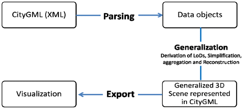
The proposed generalization framework presented in (Figure ) is based on the representation of buildings models in CityGML used for derivation of multiple LoDs, simplification, aggregation, and reconstruction processes. For this purpose, an XML-based CityGML file containing geometry and semantic information (walls, installations, etc.) of the 3D building are parsed. Multiple LoDs of 3D buildings modeled in CityGML are generated by removing multiple spatial representations at different levels. Additionally, LoD3 from LoD4 is derived by removing interiors such as IntBuildingInstallation, BuildingFurniture, roomInstallations, and InteriorRoom. Walls and other building installations are projected onto the ground. Methods for simplification and aggregation as part of the generalization process are applied to derive reconstructed models of buildings at LoD2 and LoD1. For this purpose, nodes of 2D ground plans are used to calculate the lengths of edges. Changes in the lengths of sides and removal of sides are based on the minimum length proposed for the simplification process. Subsequently, generalized LoDs are converted to CityGML. Generalized models are imported and visualized using LandXplorer CityGML Viewer 2009.
Figure 1. A framework for 3D generalization.
5. Methodology
In this research, the above framework is implemented and used for derivation of coarse LoDs, simplification and aggregation of building objects. A generalization workflow presented in (Figure ) is composed of six steps as the following: (1) derivation of coarse LoDs; (2) projection of outlier of building models; (3) simplification of segments of the ground plans extracted from the outlier of buildings; (4) aggregation; and (5) reconstruction of simplified segments of wall elements. Subsequently, generalized buildings are visualized offline. A brief summary of these steps are given below.
Figure 2. Workflow of the generalization within the framework of CityGML.
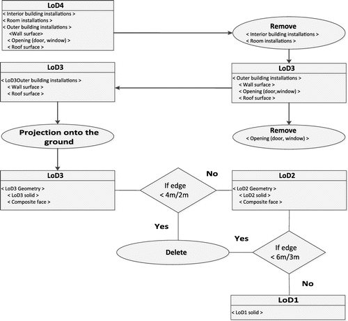
Step (1): Entire geometries and semantics are transferred from higher LoD to lower LoD with the aim to derive coarse LoD based on CityGML’s generalization specifications (Table ). For example, the polygons belonging to openings, interiors, etc. are removed followed by filling of resulted holes.
LoD4 of building modeled in CityGML contains interiors (building installation, building furniture, room installations, and interior of room) along with LoD3. With the aim to derive LoD3 from LoD4, movable and nonmovable objects of class at LoD4 such as IntBuildingInstallation, BuildingFurniture, roomInstallations, and InteriorRoom are removed. Nonmovable class objects, such as IntBuildingInstallations composed of interior stairs, railings, radiators, or pipes, which are permanently attached to the building structure cannot be removed directly so are considered to be part of LoD3. However, objects of the class IntBuildingInstallation can either be associated with a room (class room), or with the complete building/building part. After derivation of LoD3 from LoD4, the resulting object classes at LoD3 composed of OuterBuildingInstallation, Wall, Roof, and Openings (Door, Window). With the aim to derive LoD2 from LoD3, openings are removed while other outer installations are projected onto the ground for simplification purpose. OuterBuildingInstallation class is related to outer components of a building therefore strongly affects the outer characteristic of the building. This class object contains chimneys, stairs, antennas, balconies, or attached roofs above stairs and paths. These components are removed with the aim to produce LoD2. Structural features of building models need to be clubbed and formed a simple block at LoD1. Positional and height accuracy of edges of footprints must be less than 6 m × 6 m at LoD1. Therefore, lengths of edges of polygons less than specified criteria are removed directly. Otherwise, simplification process is initiated followed by aggregation of simplified blocks. The resulting LoD1 become a building block without roof in proper shape, and simplified walls as flat plane. Therefore, derivation of LoD1 from LoD2 is considered as a process of simplification and aggregation of features in LoD2. The height of all walls becomes same and size of roof plane remains same to floor plan of building model.
Step (2): with the aim of simplification, the outlier of a building model at LoD3 which does not contain windows and doors are extracted and projected onto the ground as ground plans.
Step (3): The projected ground plan is composed of different structures that need to be simplified. For this purpose, offsets, intrusions/extrusion, and corners of projected ground plans are removed based on CityGML’s generalization specification (Table ).
Step (4): Simplified ground plan segments are aggregated by the method proposed by Anders (Citation17). For this purpose, ground plans of simplified closest buildings located on a straight line are aggregated. To reconstruct simplified and aggregated 3D buildings at LoD1, the walls are raised to a certain height and displayed. Algorithms for simplification and aggregation of ground plans of 3D buildings extracted from outliers are implemented and tested on a number of buildings of Putrajaya, Malaysia.
Step (5): The results of the generalization processes are displayed in LandExplorer CityGML Viewer 2009.
5.1. Simplification of the 2D ground plan
Manual simplification of polygons of geospatial data has been practiced for a long time. These methods were applied for extending and crossing neighboring segments to remove line segments of the ground plan based on self-perceptual minimum lengths. Different values of minimum lengths have been used to simplify ground plans by different researchers. Here, in this study, simplification methods proposed by Baig and Rahman (Citation16) are adopted to simplify offset and corners of ground plans of buildings. Simplification methods adopted in our study are based on the adjustment of neighboring edges, while ground plans are aggregated based on neighboring edges and faces.
To avoid the removal or addition of important parts of the building, geometry-based rules based on CityGML specifications are imposed:
A building side smaller than a threshold (in case of LoD2, 4 m × 4 m, in case of LoD1, 6 m × 6 m) should be removed. However, in certain cases similar to a method presented by Fan et al. (Citation3), an important object which lies on the side need not be removed. If two or more smaller parts make a consecutive pattern and are smaller than the threshold, all of them need to be taken into consideration collectively not individually.
Features should be treated together if the removal or modification of them can affect the neighboring feature or if there is an overlapping between the two smaller features.
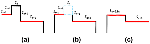
Case 1: Removal of offset
Each side of the building needs to be checked before simplification to determine if the side is smaller than the threshold. Horizontal edges are highlighted in (red) and vertical edges in (black) as shown in Figure (a). As shown in Figure (b), building side sn is smaller than the threshold and no important part of the building lies on it. Other sides connected to sn are and
. These are larger and parallel to each other and
shares an edge with
. Side
is extended to vertical side
that is reduced and results in a new side
(Figure (c)). Simplification of a footprint of building named as Mahkamah Persekutuan, Putrajaya, Malaysia, is shown in Figure .
Figure 3. Simplification of offset taking length of neighboring edges into account: original edges of offset (a), extension of the larger edge and identification of shortest edge (b), and final result of simplification process (c).
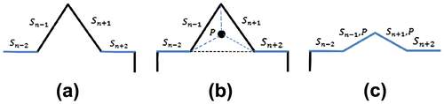
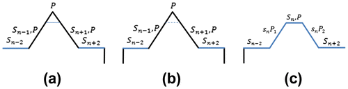
Case 2: Removal of corners
This case resembles the one in Ref. (Citation14) where a sharp corner of a segment of a building model is reduced. Both lengths of sides of segments are reduced while maintaining the shape of a segment with smooth corners. This process, simplification of a sharp corner, is shown in Figure . Both edges ( and
) of the corner converge but are not parallel (Figure (a)). However, the length of each side is the same. Center point P of the triangle formed by connecting the three vertices is calculated (Figure (b)). The vertices of edges (
) and (
) are moved to point P. The resulting edges after the simplification process become (
, P) and (
, P) shown in (Figure (c)).
Figure 4. Simplification of a segment with a sharp corner: Original corner formed by two large edges (a), creation of a triangle with center point (b), and simplified corner (c).
The simplification process to remove a sharp corner (Figure (a)) in another way is presented in Figure . If there is an important feature like a window or door overlapping with a sharp corner then the sharp corner need not be simplified. The lengths of the longer sides and
shown in (b) are reduced with (4 m × 4 m at LoD2 and 6 m × 6 m at LoD1). Then the reduced sides are connected with each other resulting in a new side (sn, P), while the resulting two shorter sides become (sn P1) and (sn P2) shown in (c). (sn, P) is removed if it is shorter than the threshold from Case 1. The original shape of the segment could not be maintained but complexity of corner has been reduced along with slight changes in the data size.
Figure 5. Removal of sharp corner: original shape of corner (a), reduction of longer edges (b), and the result of the removal of newly formed smaller edges (c).
Generalization process based on the removal of offsets and corners (see Case 1 and Case 2) was tested on footprint of a single building named Mahkamah Persekutuan, Putrajaya city of Malaysia, presented in Figure . Initially, shortest edges were removed in first iteration while remaining edges were removed in second iteration. The result shows that five out of eight trapezoids are removed after the simplification, while the trapezoid at the middle object remained the same. The computing time remained 0.04 s; however, rendering time depends upon the complexity of the input building. The generalized footprint (b) shows sufficient similarity to the original ground plan (a).
Figure 6. Simplification of a building known as Mahkamah Persekutuan, Putrajaya, Malaysia: original building footprint (a) and simplified version (b).
5.2. Aggregation of simplified ground plan
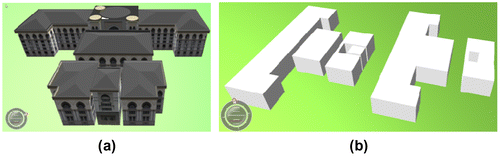
Vertices of the simplified ground plans of smaller buildings are taken into account for merging. The result of aggregation of simplified ground plans described in Cases 1 and 2 is shown in Figure . The original model of a building known as Mahkamah Persekutuan, Putrajaya, Malaysia, is shown in Figure (a). With the aim to aggregate buildings, vertices of corners of the ground plan of a smaller building lying in the middle are moved to the nearest building (Figure (b)). The middle block is aggregated with the larger building taking the distance and direction of the buildings into account. Result of aggregation process is shown in Figure (c).
Figure 7. Aggregation of simplified models: original building (a), simplified models (b), and aggregated models (c) visualized in LandXplorer CityGML Viewer 2009.
5.3. Reconstruction of simplified and aggregated ground plan
The reconstruction processes for simplified and aggregated 3D buildings are carried out separately by increasing height of the walls. LoD1 contains simple block of building with flat roof. Except in rare cases, polygons of flat roof and ground plans may be similar, therefore the projection of ground plan of building at LoD1 and outline of flat roof are enclosed within each other. Height of highest wall is considered as height of the building at LoD1. With the aim to reconstruct building at LoD1, walls with lower height are extruded to the plane of flat roof.
6. Implementation and results
Generalization of 3D building models was implemented in a C++ application. The platform, Microsoft Visual Studios 2008, runs on a PC Pentium (R) Dual-Core CPU 2.10 GHz, 2.00 GB RAM, and Microsoft Windows 2007. Implementation of generalization process is divided into two steps. (1) Removal of building parts and installations based on semantics at four levels of detail, LoD1 to LoD4 from a structured data-set of buildings represented in CityGML. (2) Extraction and geometric transformation of ground plans generated from exterior of buildings.
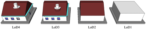
In the first step, entire geometries and semantics of higher LoD stored in a data structure are removed to derive lower LoD. In order to derive LoD3 from LoD4, polygons of interior building installations, building furniture, room installations, and interior of room are removed from models at LoD4. With the aim to derive LoD2, the polygons of openings (doors and windows) represented as BoundarySurface as thematic objects are removed. Similarly, this geometric representation is refined in LoD2 by additional MultiSurface and MultiCurve geometries. Removal of an embedded door or window with wall remained a challenge. Boundary of such an opening is considered as a hole and filled. Associated solid geometries of components at LoD2 such as LinearRing as the boundary of the surface object (which also might be a CompositeSurface and MultiSurface) are used for further processing. Figure shows derived coarse LoDs (LoD4–LoD1).
Figure 8. Derived coarse LoDs from left-to-right (LoD4–LoD1).
As part of the second step, geometric as well as semantic information including outliers of the 3D buildings at LoD3 except openings (doors and windows) were used. A decomposed 3D building outlier was used for further processing. Geometric transformation of projected ground plans of exteriors is implemented using math libraries of C++. Data structures are created and algorithms for arrangements of edges, geometry processing, and convex hull algorithms are implemented. Algorithms were operated on nodes of ground plan polygons and performed geometric tests on them. Lengths and locations of polygon nodes of complex structures were analyzed. Length of each edge was calculated based on x and y coordinates of nodes and stored in a variable temporarily to be used to determine shortest edges. Each edge of polygon is checked and removed based on threshold values specified by CityGML. Algorithms presented in Case 1 and Case 2 were implemented and tested on a number of buildings of Putrajaya city of Malaysia with the aim to derive LoD1.
Initially, two buildings, the Jabatan Pendaftaran Negara and the Putra Mosque of Putrajaya, having complicated structures with offsets and sharp corners, were simplified and aggregated. Subsequently, the generalization procedures were applied and tested on a data-set containing 23 outer shells of Putrajaya around the MaCGDI (Malaysian Center for Geospatial Data Infrastructure). Reduction in size of the generalized building models was calculated. An analysis of data reduction due to the simplification process is given in Table . The results show that the percentage of data reduction is inversely proportional to the minimum length of the edges, but other aspects like the designs of buildings cannot be ignored.
Table 2. Percentage of data reduction based on minimum length of generalized objects.
The result of all the proposed simplification and aggregation procedures presented in this paper to derive LoD1 from LoD2 and LoD3 of building models of Putrajaya, Malaysia (Figure ) are visualized in LandXplorer CityGML Viewer V, 2009. Simplified and aggregated building models at LoD1 are shown in Figure . However, the closest buildings are aggregated as shown in Figure . Based on different perspective, buildings closer to the view point of a user seem to be less generalized compared to those further from the user in a street view.
Figure 9. 3D building models of a portion of Putrajaya, Malaysia, visualized in LandXplorer CityGML Viewer 2009.
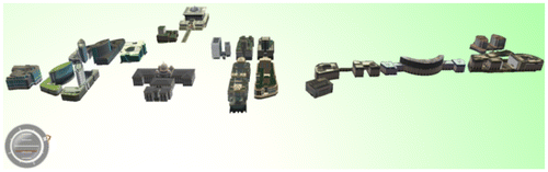
Figure 10. Generalization of 3D buildings: simplification models (left) and simplified and aggregated models (right).
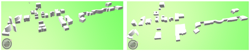
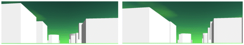
Figure 11. Street views of generalized buildings from two different perspectives, visualized in LandXplorer CityGML Viewer 2009.
7. Discussion and conclusions
In this study, we used a parser to retrieve the components of buildings represented in CityGML. Semantics as well as geometry of buildings modeled in CityGML were parsed and populated data objects. Although, as part of this study, it was not scientifically experimented to determine how much data are reduced or lost during conversion from CityGML to data objects. However, a slight decline in the size of data after conversion was observed.
The algorithms for derivation of LoD1 and LoD2 were tested for a small data-set containing 23 buildings at Putrajaya city of Malaysia. The result shows that the data reduction is differently proportional to the length of threshold values. Only 37.65% of data is reduced after generalization at LoD1 compared to 30.18% at LoD2. The difference of percentage of data reduction between the two threshold values (e.g. 4 and 6 m) remained 7.47%.
A comparison of results of this study with a recent study by Baig and Rahman (Citation18) is evaluated to determine the level of difference of their appearance and data reduction. In both studies, data reduction is directly proportional to the length of threshold values, but at threshold values (e.g. 4 and 6 m) the difference of percentage of data reduction is 10.5 and 30.62%, respectively.
Further research to generate a BuildingTree to store generalized LoDs as a multiple data structure will be conducted. To interact with the user, a Graphical User Interface will be designed and implemented to pass parameters to all generalization processes in future.
Notes on contributors
Siddique Ullah Baig obtained an MSc in Photogrammetry and Geoinformatics in 2009 from Hochschule für Technik, Stuttgart, Germany. In 2013 he received a PhD (Geoinformatics) from Universiti Teknologi Malaysia for this thesis “A three-step strategy for generalization of three-dimensional buildings modelled in City Geography Markup Language”.
Alias Abdul-Rahman is a professor at the Department of Geinformation, Faculty of Geoinformation and Real Estate, Universiti Teknologi Malaysia (UTM), Skudai, Johor in Malaysia. In 2000 he received his PhD degree from University of Glasgow, Scotland, UK.
Acknowledgments
We would like to convey our deepest acknowledgement firstly to Universiti Teknologi Malaysia (UTM) for providing research grant Vote No. Q.J130000.7127.04J81. Last but not least our sincere appreciation to The Research Management Centre (RMC) of UTM and The Ministry of Higher Education (MOHE), Malaysia for enabling us to carry out this research project.
References
- Kolbe, T.H. Representing and Exchanging 3D City Models with CityGML. In 3D Geo-Information Sciences: Lecture Notes in Geoinformation and Cartography: Lee, J., Zlatanova, S., Eds.; Springer: Berlin, 2009; pp 15–31.
- Open Geospatial Consortium (OGC). OGC City Geography Markup Language (CityGML) En-coding Standard, OpenGIS® Encoding Standard (Ver. 2.0.0, 2012-04-04). https://portal.opengeospatial.org/files/?artifact_id=47842 (accessed Jan 16, 2013).
- Fan, H.C.; Meng, L.Q.; Jahnke, M. Generalization of 3D Buildings Modelled by CityGML. Advances in Giscience: Lecture Notes in Geoinformation and Cartography: Sester, M., Bernard, L., Paelke, V., Eds.; Springer: Berlin, 2009; pp 387–405.
- Mao, B.; Ban, Y.F.; Harrie, L. A Multiple Representation Data Structure for Dynamic Visualisation of Generalised 3D City Models. ISPRS J. Photogramm. Remote Sens. 2011, 66, 198–208.
- Gröger, G.; Kolbe, T.H.; Czerwinski, A. Candidate OpenGIS® CityGML Implementation Specification (City Geography Markup Language) (Ver 0.4.0, 2007-06-17). http://portal.opengeospatial.org/files/?artifact_id=22120 (accessed Jan 16, 2013).
- Kolbe, T.H.; Nagel, C.; Stadler, A. CityGML – OGC Standard for Photogrammetry?, Presented at the Photogrammetric Week 2009, Stuttgart, Germany. www.ifp.uni-stuttgart.de/publications/phowo09/270Kolbe.pdf (accessed Jan 27, 2013).
- Guercke, R.; Brenner, C. A Framework for the Generalization of 3D City Models. Proceedings of the 12th AGILE International Conference on Geographic Information Science, Leibniz Universität, Hannover, Germany, 2009.
- Forberg, A. Generalization of 3D Building Data Based on a Scale-space Approach. ISPRS J. Photogramm. Remote Sens. 2007, 62, 104–111.
- Kada, M. Generalization of 3D Building Models by Cell Decomposition and Primitive Instancing. Proceedings of the Joint ISPRS Workshop on “Visualization and Exploration of Geospatial Data”, Stuttgart, Germany, 2007.
- Mayer, H. Scale-spaces for Generalization of 3D Buildings. Int. J. Geogr. Inf. Sci. 2005, 19, 975–997.
- Meng, L.; Forberg, A. 3D Building Generalisation. In Challenges in the Portrayal of Geographic Information: Issues of Generalisation and Multi Scale Representation: Mackaness, W., Ruas, A., Sarjakoski, T., Eds.; Elsevier Science: Amsterdam, 2006; pp 211–232.
- Sester, M. Optimization Approaches for Generalization and Data Abstraction. Int. J. Geogr. Inf. Sci. 2005, 19, 871–897.
- Fan, H.C.; Meng, L.Q. Automatic Derivation of Different Levels of Detail for 3D Buildings Modelled by CityGML. Proceedings of the 24th International Cartography Conference, Santiago, CL,Chile, 2009.
- Sester, M.; Brenner, C. Continuous Generalization for Visualization on Small Mobile Devices. The Developments in Spatial Data Handling-11th International Symposium on Spatial Data Handling, Springer: Berlin, 2004.
- Fan, H.C.; Meng, L.Q. A Three-step Approach of Simplifying 3D Buildings Modeled by CityGML. Int. J. Geogr. Inf. Sci. 2012, 26, 1091–1107.
- Baig, S.; Rahman, A. Generalization and Visualization of 3D Building Models in CityGML. In Progress and New Trends in 3D Geoinformation Sciences: Pouliot, J., Daniel, S., Hubert, F., Zamyadi, A., Eds.; Springer: Berlin, 2013; pp 63–77.
- Anders, K.H. Level of Detail Generation of 3D Building Groups by Aggregation and Typification. Proceedings of the XXII International Cartographic Conference, A Coruña, Spain, 2005.
- Baig, S.; Rahman, A. A Three-step Strategy for Generalization of 3D Building Models Based on CityGML Specifications. GeoJournal. 2013, online DOI: 10.1007/s10708-013-9475-0.