
Abstract
Wetlands play an important role in the provision of ecosystem services, ranging from the regulation of hydrological systems to carbon sequestration and biodiversity habitat. This paper reports the mapping of Indonesia’s wetland cover as a single thematic class, including peatlands, freshwater wetlands, and mangroves. Expert-interpreted training data were used to identify wetland formations including areas of likely past wetland extent that have been converted to other land uses. Topographical indices (Shuttle Radar Topography Mission-derived) and optical (Landsat) and radar (PALSAR) image inputs were used to build a bagged classification tree model based on training data in order to generate a national-scale map of wetland extent at a 60 m spatial resolution. The resulting wetland map covers 21.0% (39.6 Mha) of Indonesia’s land, including 25.2% of Sumatra (11.9 Mha), 22.9% of Kalimantan (12.2 Mha), and 28.9% of Papua (11.8 Mha). Results agree with existing image-interpreted products from Indonesia’s Ministries of Forestry and Agriculture and Wetlands International (89% overall agreement), and with the Ministry of Forestry forest inventory data for Sumatra and Kalimantan (91% overall agreement). An internally consistent algorithm-derived national wetland extent map can be used to quantify changing rates of land conversion inside and outside of wetlands. Additionally, wetlands extent can be used to efficiently allocate field resources in national assessments of wetland sub-types such as peatlands, which are a current focus of policies aiming to reduce carbon emissions from land use change.
1. Introduction
As an ecotone between aquatic and terrestrial ecosystems, wetlands provide habitat for a variety of aquatic and terrestrial species, as well numerous ecosystem services. Tropical wetlands maintain high rates of primary productivity as well as anaerobic soil conditions that slow down decomposition (Citation1–Citation3). As a result, wetlands represent one of the largest terrestrial biological carbon pools (Citation4). Wetlands are often unsuitable for agricultural land uses and in many places remain largely intact (Citation3). However, when land use intensification options are limited, wetlands often become a site of land use change (5); for example, the development of agro-industrial plantations in Indonesia. In Indonesia, most non-wetlands lowland forests have been allocated for forest logging concessions since the 1960s (Government regulation 21/1970 and 18/1975). As more non-wetlands lowland forests have been used in logging operations, forestry activities have moved into wetlands. Since then, wetland conversion and degradation have accelerated.
The loss or degradation of wetlands reduces the watersheds capacity to maintain biodiversity, water quality, flood deterrence, and carbon sequestration (Citation4). National concern for Indonesia’s wetlands has grown following the extensive smoke pollution from smoldering peatlands in Sumatra and Kalimantan islands, capturing the attention of scientists and politicians around the world due to the magnitude of carbon emissions released (Citation6–Citation11). Indonesia, largely due to emissions from peatland soils, is second to only Brazil in greenhouse gas emissions for tropical countries. The exceptional carbon storage and potential emissions from land use change within wetlands have implications for global climate change (Citation3, Citation12). For many policy initiatives, such as the United Nations Framework Convention on Climate Change (UNFCCC) Reducing Emissions from Deforestation and forest Degradation (REDD) program, the monitoring of wetland land use change is of critical importance.
Remote sensing data have been applied widely to monitor land cover change, mostly in terms of deforestation and forest degradation (Citation13–Citation20). At the same time, remote sensing has also been used to map wetland extent (Citation4, Citation21, Citation22, Citation24). For many monitoring applications, the quantification of wetland extent is required. To date, a number of national-scale wetland mapping products using image interpretation have been generated. Available maps of wetlands distribution include the national land cover map developed by the Ministry of Forestry of Indonesia (MoF) and a peatlands distribution map from the collaboration between Wetlands International and the Ministry of Agriculture of Indonesia (WI/MoAg). More systematic methods using digital image processing and characterization at the national scale have not been implemented. In this study, we apply such an approach and compare results with existing maps and available ancillary data. Our product attempts to capture near-term historical wetland extent without regard to recent conversions of wetlands to other land uses, such as palm estates. As such, it can be used as a reference for quantifying recent land change dynamics by wetland or non-wetland status.
2. Objectives
The objective of this research was to map near-term historical wetland extent in Indonesia using passive optical, Landsat, and active radar PALSAR, data-sets, and elevation-derived topographical indices. The topographical indices were derived from data from the Shuttle Radar Topography Mission (SRTM) and were employed to represent landform and hydrological conditions. This research aims to answer the following questions: (a) how accurate is an algorithm-driven national-scale map compared to heritage image-interpreted maps, and (b) what spectral or spatial inputs enable the mapping of wetland extent in Indonesia.
3. Materials and methods
3.1. Study area
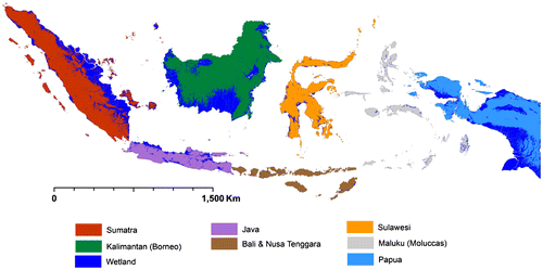
Indonesia is the largest country in Southeast Asia with approximate latitude of 4°000′ N to 11°00′ S and longitude of 94°00′ to 140°00′ E. The major island groups, listed largest to smallest, include Kalimantan (Indonesian portion of Borneo), Papua (Indonesian portion of New Guinea), Sumatra, Sulawesi, Maluku, Java, and Bali-Nusa Tenggara (Figure ). Indonesia has a tropical climate with temperatures ranging from 28 °C in the coastal plains to 26–23 °C inland and within mountain areas. In the Köppen-Geiger climate classification, Indonesia is categorized as Af (tropical wet) with ≥60 mm precipitation during the driest month (Citation25). Given the fairly consistent temperatures, the most influential variable on climate is rainfall. The dry season occurs principally from June through September, and the rainy season from December through March. On average, throughout the year, rainfall ranges from 125 to 280 mm per month (Citation26, Citation27), and precipitation always exceeds evapotranspiration (Citation28) causing a relative humidity ranging from 70 to 90%. As a result, given suitable geomorphology, Indonesia has an abundance of water to support wetlands formation.
3.2. Characteristic and rationale
We define wetlands as “lands transitional between terrestrial and aquatic systems where the water table is usually at or near the surface or the land is covered by shallow water” (Citation29, Citation30). The presence of wetlands is a function of climate and landform, and wetlands often have characteristic flora and soils (Citation29, Citation31). Our approach to digital mapping posits that water presence, landform, and vegetation type can be observed using multi-source data-sets. Such data-sets, processed consistently over large areas, enable the delineation of wetlands at national scales. Specifically, Landsat imagery capture floristic differences that can be associated with wetland status, as well as water extent and leaf moisture content, both indicators of possible wetland status. Topographical indices capture landforms more likely to retain water. The different interactions of microwave data (PALSAR) with surface water compared to vegetation enable improved discrimination of wetlands. All three data sources have complementary characteristics that warrant their combined use in characterizing wetland extent (Citation23, Citation32).
3.3. Data and methods
3.3.1. Satellite imagery
Landsat data inputs included Landsat 7 Enhanced Thematic Mapper Plus (ETM+) and Landsat Thematic Mapper (TM) imagery, downloaded from US Geological Survey National Center for Earth Resources Observation and Science (http://glovis.usgs.gov/). A cloud-free mosaic for year 2000 was generated. We selected year 2000 due to its temporal proximity to the SRTM acquisition date of 2000. All Landsat input images were re-projected to a sinusoidal project and resampled to a 60 m spatial resolution. The raw digital numbers (DN) were converted to top of atmospheric reflection (Citation33) to minimize differences in ETM+ values that resulted from sensor calibration, sun–earth distance, and sun elevation. Each pixel was subsequently screened for clouds/haze/shadows/water per the method of Potapov et al. (Citation34), resulting in a set of quality-assessed land observations. Radiometric normalization was conducted using top of canopy reflectance MODIS data in order to remove residual atmospheric contamination and surface anisotropy (Citation35). A single composite image, using nearest quality-screened observation to 1 January 2000, for the following Landsat bands was created: red (630–690 nm), near-infrared (760–900 nm), and short-wave infrared (1550–1750 and 2080–2350 nm).
The digital elevation data used for this research were derived from the SRTM flown on board the shuttle Endeavour for 11 days in February 2000 (Citation36). The DEM was derived from a single-pass interferometric synthetic aperture radar (InSAR) (Citation37, Citation38) at spatial resolution levels of 3 arc-seconds (approximately 92 m) (Citation36, Citation39). The data are available to the public at US Geological Survey’s Earth Resources Observation System (EROS) Data Center for FTP download.
The radar data used in this study were from the phased array L-band synthetic aperture radar, (PALSAR), on board the Advanced Land Observing Satellite (ALOS). The data are delivered as 50 m spatial resolution orthorectified mosaics provided by the Kyoto and Carbon (K&C) Initiative led by Japan’s Aerospace Exploration Agency (JAXA). From the available 72 alternatives fine-beam (FB) modes in PALSAR, the single-polarization HH and dual-polarization HH + HV have been selected for operational use (Citation22). These modes yield a 70 km swath width and 10 m × 10 m and 10 m × 20 m ground resolution in HH and HH + HV, respectively (Citation40). The ALOS PALSAR mosaic tiles were acquired from June to October 2009 for Sumatra, Kalimantan, Java, Nusa Tenggara, Sulawesi, and Maluku islands, and from May to October 2008 for Papua. A total of 21 PALSAR tiles covering Indonesia for HH and HH + HV polarizations were used as independent variables for mapping the wetlands.
3.3.2. GIS and field data-sets
We used several ancillary data-sets for data validation, product comparison, and analysis. A digital peatlands distribution map produced by the Ministry of Agriculture and Wetlands International (WI) (MoAg 2011) was obtained from the MoAg. A land cover map for 2000, obtained from the MoF, includes wetland-related land cover classes. Both reference wetland maps were generated using on-screen image interpretation. The WI/MoAg map had an additional input of field survey data of substrate (physicochemical features)/soils types in determining peatland soil types and depth. For comparison purposes, the following MoF land cover classes were aggregated to create a generic wetland class: primary swamp forests, secondary swamp forests, primary mangrove forests, secondary mangrove forests, swampy shrub, paddy field, fish pond, and open swamp (grassy swamp). The reported accuracy of the MoF land cover map is 88% (Citation20, Citation41). The estimated accuracy of the WI/MoAg map land is 70–80% (MoAg 2012 personal communication). Our reference wetland layer consisted of areas where either the WI/MoAg peatland or MoF wetland maps indicated wetland land covers.
We employed field data from the Indonesian National Forest Inventory (NFI) obtained from the MoF to further evaluate the derived wetland map. The NFI data were collected from a systematic sampling grid of 20 × 20 km (UTM zone) for all forestlands/state forests below 1000 m altitude (Citation42, Citation43). Permanent sample plots (PSP) are 100 m by 100 m in extent and are measured every 3–5 years, including wetland/dry-land status. We used 427 PSPs from Sumatra and 881 PSPs from Kalimantan collected between 1995 and 2000 to compare with the output wetland map. In the PSP data, 138 plots (32.3%) and 156 plots (17.7%) were recorded as wetlands for Sumatra and Kalimantan, respectively.
3.3.3. Topographical indices
We employed the approach of Bwangoy et al. (23) in deriving a set of topographical indices to be used as inputs to the wetland mapping task. A number of metrics that quantify the effects of topography on hydrological processes were derived from digital elevation data including first- and second-order derivatives of elevation (e.g. slope and curvature) (Citation44, Citation45). The derivatives were generated by fitting a quadratic function to the digital elevation model. A quadratic function is a successful compromise between a number of data points required to uniquely model the surface and the fidelity in which the model fits the true surface (Citation44). Quadratic coefficients were generated by an ordinary least squares (OLS) fitting of nine neighboring DEM pixels. In addition, we calculated the root mean square error of the OLS fitting to indicate quality of the fit, and employed as independent variable. Finally, five metrics describing relative height with respect to variously defined support area/catchment sizes were calculated. The hydrological topology was defined using the D8 method to compute flow direction, the upslope contributing area (flow accumulation), and catchment (Citation46–Citation49). Drainage channels were extracted at all points with accumulated areas above a threshold defined by a support area parameter; all cells having at least as many cells flowing to them as the threshold value are determined to be “streams.” Each stream catchment was then used to calculate a relative elevation per pixel by subtracting actual elevation from the minimum elevation of the defined catchment. Five relative elevations were calculated for 1000, 5000, 10,000, 15,000, and 20,000 SRTM 90 m grid cell support areas (23).
3.3.4. Training data and decision tree classification
A systematic pixel-wide grid of 100 km × 100 km in X and Y directions was used to derive training data and to estimate the proportion of land covered by wetlands. Each pixel along all transects was labeled as either wetland or non-wetlands via image interpretation of the 2000 image composite. In total, 1,286,943 training pixels were collected in this manner, of which 263,419 (20.5%) were labeled wetlands. The systematic sample provided an estimate of the actual class proportions, similar to prior probabilities. The 20.5% estimate of wetland extent was used as a reference in guiding the derivation of the final wetland map. However, such sampling does not ensure a high-fidelity map output due to the complexity of landscapes and input variable features. Consequently, additional, non-systematically collected training data were added to the initial training by image interpreters in iterating the product as in Bwangoy et al. (23). Decision trees have been widely used to characterize tropical wetlands using either passive or active remotely sensed data-sets (Citation32, Citation50–Citation52). Using an entropy or deviance measure, decision trees classify each pixel by splitting on independent variables (e.g. Landsat bands) in order to create more homogeneous subsets regarding class membership (Citation53). A single classification tree, terminated when a given node captured 0.1% of the training data’s total deviance, was generated and applied to the entire national-scale data-set.
4. Results
4.1. Independent variables for mapping wetlands
Among the number of independent variables applied for classification, the most influential are root mean square error (RMSE), Landsat band 5, and relative elevation of 121.5 km2 (15,000 support area) catchments (Table , Figure (b–e)). Various curvature and convexity derivatives, except plan convexity, did not contribute to the decision tree. The RMSE of the fitted model indicates how well the quadratic describes the digital elevation model. Low RMSE values indicate closer agreement between the model and the actual topography, and are indicative of flat areas suitable for water inundation. Higher RMSE values are found in areas of high relief, areas less likely to retain surface water. The RMSE variable accounted for nearly half of the model’s reduction in deviance. Landsat band 5 contributed 14.5% and is the second highest contributor to the classification. Landsat band 5 is useful for identifying wetlands due to its ability to distinguish vegetation types as well as leaf and soil moisture content (Citation54). The relative elevation based on a 121.5 km2 (15,000 support area) catchment area was third overall in contributing to wetland characterization, followed by 162.0 km2 (20,000 support area) and 40.5 km2 (5,000 support area) catchment sizes. Relative elevation is an indicator of catchment slope and the possible presence of wetlands. While SAR data have also been renowned as a valuable tool for wetlands mapping (Citation21, Citation50), the PALSAR dual and single polarized data contributed only 3.95% for HH + HV polarization and 1.96% for HH polarization of deviance reduction.
Table 1. Significant contribution from independent variables to map per-pixel wetland probability.
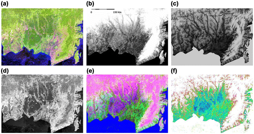
Figure 1. Example inputs and map results for a part of Central Kalimantan Province (centered approximately at 114°10′24.86″ E, 2°22′53.54″ S): (a) Landsat image with 5–4–3 spectral combination; (b) fit of the model represented by the RMSE; (c) relative elevation of 121.5 km2 catchments; (d) Landsat band 5; (e) false-color r-g-b of (b), (c), and (d); and (f) the initial resulting wetland map as a probability layer where blue is high probability and white low probability.
4.2. Post classification
An objective of this study was to depict naturally occurring wetlands, even for areas that previously experienced land use conversion. As such, we delineated wetland training on a number of land uses, such as oil palm estates, which had been introduced to wetland landscapes. Our per-pixel mapping method was found wanting for a number of these areas and required a post-classification procedure to minimize errors of omission regarding recent historical land use conversions.
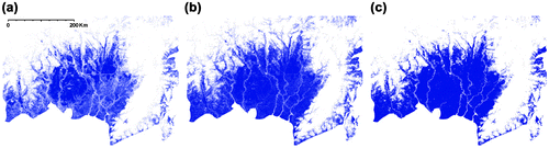
Two post-classification procedures were performed and are illustrated in Figure . The per-pixel classified map in Figure (a) represents the original wetlands map created from the decision tree classification. Figure (b) is the first post-classification step derived using a DEM-based buffer. Any non-wetland pixels within five pixels of a wetland pixel and having an elevation difference of less than or equal to 2 m was relabeled a wetland. Figure (c) illustrates the final result based on a second post-classification process, a filtering of (b) to clean up all polygons of 20 pixels or less. The values of for each heuristic were arrived through trial and error in order to ameliorate the wetland conversion artifacts. Both steps removed noise in the product, particularly related to land uses within wetlands, resulting in a more generalized depiction of wetland extent.
Figure 2. Post-classification steps to refine original wetlands mask from noise. This example is given from Central Kalimantan Province (centered approximately at 114°10′24.86″ E 2°22′53.54″ S); (a) a per-pixel original wetland mask; (b) a map produced by buffering the per-pixel original wetland mask; and (c) a final wetlands map produced by smoothing map b.
4.3. Product comparison
We combined the WI/MoAg peatland map (Figure (a)) and the wetland land cover classes of the MoF map (Figure (b)) to create a reference map (Figure (c)) for comparison to our wetland classification. Any pixel characterized in either map as peatland or wetland was included in the reference wetlands layer. We evaluated both the per-pixel and post-classification versions of our map (Figure (a) and (c)) against the reference map (Figure (c)) for the entirety of Indonesia (Table ). We also compared our map results with NFI field data-sets for Sumatra and Kalimantan (Figure ). In this work, we utilized non-wetland (dry) land or wetland status per PSP. Results in Table include a comparison of PSPs with the existing image-interpreted map. The PSPs were measured at various times from 1995 to 2000. The existing image-interpreted map has high agreement (Table ). Disagreements are mostly along rivers or in the boundary of wetlands and non-wetlands. The final wetland map significantly improves the overall and producer’s agreement when compared to the PSPs, though there is a minor increase in commission error.
Figure 3. The existing image-interpreted map for part of Central Kalimantan Province centered at approximately 114°10′24.86″ E 2°22′53.54″ S; (a) peatlands distribution map; (b) land cover map; and (c) the aggregated map of (a) and (b) as reference.
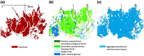
Table 2. Product comparison of Indonesia-wide initial and final wetland map products of this study, with existing image-interpreted maps.
Figure 4. (a) The permanent sample plot (PSP) of NFI data for Sumatra over the Sumatra wetlands; (b) the PSPs of NFI data for Kalimantan over the Kalimantan wetland. The final wetland product is in blue, PSPs with wetland category are in green, and PSPs with non-wetland category (dry-land) are in red.
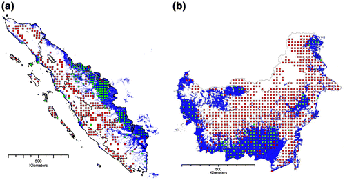
Table 3. Product comparison of original wetlands mask, final wetlands map, available image-interpreted map, and the NFI field plots of Sumatra and Kalimantan.
4.4. The agreement and disagreement assessment
Table summarizes inter-product agreement and Figure illustrates examples from Papua and Sumatra. Disagreements are largely related to the mapping methods, specifically the more detailed per-pixel digital approach compared to the image-interpreted method. Greater detail depicted by the algorithmic approach is found inside and outside of the general wetland features delineated by the interpretation method.
Figure 5. The map for agreement/disagreement for example inland wetlands in West Papua Province (centered at 138°59′30.02″ E 3°10′50.18″ S) on the left, and riparian wetlands in South Sumatra Province (centered at 103°26′20.4″ E 1°56′45.6″ N) on the right; for (a) Landsat image with 5–4–3 spectral band combination and (b) the wetlands/non-wetlands agreement and disagreement.
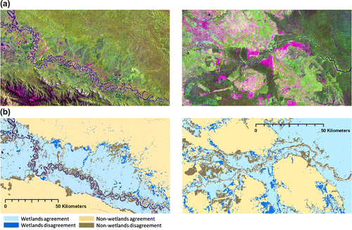
Figure 6. The national wetlands map of Indonesia on the seven largest islands of Indonesia.
4.5. National wetlands: the extent and its distribution
The extent of Indonesia’s wetlands (Figure ) is estimated to be 21.0% of the total land area, totaling 39.6 Mha. Detailed assessment of the original wetland mask derived from the decision tree classification and the final wetland map is shown in Table . Indonesian wetlands consist of peat swamps, freshwater swamps, mangrove swamps, woodlands swamps (sago palm/Metroxylon sagu and pandan/Pandanus amaryllifolius), herbaceous swamps, grass swamps, and savannas (Citation55, Citation56). As summarized in Table , wetlands are distributed primarily in Sumatra (30.1%) or 25.2% of Sumatra’s land; Kalimantan (30.8%) or 22.9% of Kalimantan’s land; and Papua (29.9%) or 28.9% of Papua’s land.
Table 4. The Indonesian wetlands area extent and its distribution per each major island.
From the ancillary databases and other sources(Citation55–Citation63), Indonesia’s natural wetlands are estimated to cover approximately 44 Mha. The WI/MoAg/MoF wetlands map totals 41.2 Mha. Our map is a more conservative representation of 39.6 Mha of wetland extent.
5. Discussion
5.1. Independent variables and wetlands discrimination
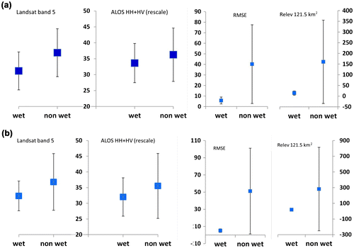
Topographical indices such as RMSE and relative elevation of 121.5 km2 catchment area are the first and third most important discriminators of wetlands (Table ). Figure shows the mean values for these two variables, all significantly different for wetlands and non-wetlands classes. Additionally, Landsat band 5 and PALSAR polarization indices, useful for observing vegetation and soil moisture content (Citation21, Citation50, Citation54), were found to be significantly different for the two classes. However, of the respective topographical, passive optical, and active microwave information sources, it is clear that landform information based on topographical modeling is the most useful information for mapping wetlands.
Figure 7. The mean and standard deviation of four of the most important independent variables (RMSE, Landsat band 5, relative elevation of 121.5 km2 catchments, and ALOS PALSAR HH + HV polarization) for the original wetlands mask sampled for existing NFI data, for (a) Kalimantan, 105 wetlands plots and 679 non-wetlands plots, and (b) Sumatra, 86 wetlands plots and 280 non-wetlands plots. The t-test summary yielded a p value of <0.000 with 95% confidence with respect to the degrees of freedom of 780 for Kalimantan and 362 for Sumatra.
5.2. Original wetlands mask versus post-classification product
The dynamic forest cover change in Indonesia posed a challenge for mapping wetlands. While a number of wetlands have been drained and converted to agro-industrial land uses, the objective of the exercise was to delimit potential natural wetland extent. This is different from the wetland map of Bwangoy et al. (23) for the Democratic Republic of the Congo, where almost no conversion of natural wetlands has occurred (Citation64). The mapping of potential wetland without regard to current land use led to a greater use of topographical indices in the characterization of Indonesian wetlands. For example, Landsat spectral responses of existing peatland forest, cleared peatland forest, or subsequent oil palm estate, could all be labeled as wetland in this exercise. As a result, the topographical data became the clear driver of the mapping algorithm. Flat areas with low relative elevation across various catchment sizes indicated potential wetland more readily than the Landsat or PALSAR inputs. However, the Landsat bands and PALSAR (Figure ) data were important, contributing more than 25% of the deviance reduction in mapping wetlands (Table ). Post classification was deemed necessary to overcome limitations in more completely mapping converted wetlands. The post-classification process increased wetland extent by 33% overall (Table ). Per island group, Java had the highest increase (51.4%), followed by Sumatra, Sulawesi, Papua, and Kalimantan. Post processing improved final map agreement by 3.1% overall, 18.9% for producer’s agreement, 0.9% of user’s agreement, and 13% of Kappa.
5.3. Wetlands and its spatial distribution for major islands
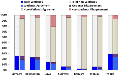
Sumatra, Kalimantan, and Papua contain roughly 30% of Indonesian wetland area totaling 35.8 Mha (Table ), close to the area of the WI/MoAg/MoF map (34.8 Mha). Greatest areal disagreements are found where artificial wetlands are present. Indonesia has extensive artificial wetlands from agriculture and aquaculture land uses (Citation55–Citation57, Citation65–Citation67) found largely in Java, Sulawesi, and some parts of Sumatra. Many artificial wetlands, for example terraced rice paddies, are not depicted in the map made for this study. However, they are part of the combined WI/MoAg/MoF map. Figure illustrates this disagreement for Java, where extensive artificial wetlands are indicated as errors of omission in the new wetlands map. Java alone captures more than 20% of non-wetland disagreement. For island groups with less artificial wetlands, there is less disagreement between the map and reference data-sets.
Figure 8. The percentage of wetlands and non-wetlands extent, including agreement/disagreement for each major island group for the derived map and the WI/MoAg/MoF product.
6. Conclusions
Topographical indices (SRTM-derived) and optical (Landsat) and radar (PALSAR) image inputs were used to implement a supervised classification of Indonesia’s wetlands as a single thematic class encompassing peatlands, mangroves, and other freshwater wetlands. The results agree with existing image-interpreted products from Indonesia’s Ministries of Forestry and Agriculture and Wetlands International (WI/MoAg/MoF), as well as with forest inventory data from the Ministry of Forestry. Overall agreement when compared with forest inventory data indicates slightly lower, but comparable accuracies with the image-interpreted WI/MoAg/MoF map.
A significant challenge in establishing a land use history for Indonesia is the quantification of past wetland extent. This study attempted to create a baseline wetland extent map, upon which recent land use change can be mapped. Such a product can be used to estimate rates of forest change, both inside and outside of wetlands, as an input to carbon emissions models, and in support of biodiversity assessment efforts. The presented map was implemented at the national scale using a systematic, algorithmic approach. As such, it represents an internally consistent quantification of Indonesian wetland extent, suitable for science and policy applications related to wetland ecosystem services and their change over time.
Notes on contributors
Belinda A. Margono is a professional forester and remote sensing scientist from the Directorate General of Forestry Planning, Ministry of Forestry of Indonesia. Her research is focused on mapping land use and land cover dynamics in Indonesia by utilizing multi-source remotely sensed imagery.
Jean-Robert B. Bwangoy is a professional forester from the Congolese Ministry of Environment and Nature Conservation and teaching assistant at the University of Kinshasa, Agronomy Department. His work combines forest inventory data and land cover from remotely sensed data in improving forest monitoring.
Peter V. Potapov is a professional biologist and remote sensing scientist with a research specialization in developing algorithms for large area monitoring of land change using remotely sensed data-sets. He took part in developing first of their kind global Landsat-based forest change products including the Intact Forest Landscape data-set.
Matthew C. Hansen is a remote sensing scientist with a research specialization in large-area land cover and land use change mapping. His research is focused on developing improved algorithms, data inputs, and thematic outputs that enable the mapping of land cover change at regional, continental, and global scales.
Acknowledgments
Support for this study was provided by AUSAID through the Indonesian National Carbon Accounting System project and by the United States National Aeronautics and Space Administration’s Land Cover and Land Use Change program through grant NNG06GD95G. The authors thank the Ministry of Forestry of Indonesia and Ministry of Agriculture of Indonesia for providing data. The authors also thank colleagues from the University of Maryland (LeeAnn King) for improving manuscript language, and (in-Young Yeo) for guiding hydrological references; colleagues from the Ministry of Forestry (Firman Fahada and Judin Purwanto) for supporting spatial/non-spatial data preparation; and from the Ministry of Agriculture (Wahyunto) for technical consultation.
References
- Brinson, M.M.; Lugo, A.E.; Brown, S. Primary Productivity, Decomposition and Consumer Activity in Freshwater Wetlands. Annu. Rev. Ecol. Syst. 1981, 12, 123–161.
- Neue, H.U.; Gaunt, J.L.; Wang, Z.P.; Becker-Heidmann, P.; Quijano, C. Carbon in Tropical Wetlands. Geoderma 1997, 79, 163–185.
- Murdiyarso, D.; Donato, D.; Kauffman, J.B.; Kurnianto, S.; Stidham, M.; Kanninen, M. Carbon Storage in Mangrove and Peatland Ecosystem: A Preliminary Account from Plots in Indonesia; Working Paper 48. CIFOR, 2009.
- Zedler, J.B.; Kercher, S. Wetland Resource: Status, Trends, Ecosystem Service, and Restorability. Annu. Rev. Environ. Res. 2005, 30, 39–74.
- Gong, P.; Niu, Z.G.; Cheng, X.; Zhao, D.M.; Zhou, D.; Guo, J.H.; Liang, L.; Wang, X.F.; Li, D.D.; Huang, H.B.; Wang, Y.; Wang, K.; Li, W.N.; Wang, X.W.; Ying, Q.; Yang, Z.Z.; Ye, Y.F.; Li, Z.; Zhuang, D.F.; Chi, Y.B.; Zhou, H.Z.; Yan, J. China’s Wetland Change (1990-2000) Determined by Remote Sensing. Sci. China Earth Sci. 2010, 53 (7), 1036–1042.
- Page, S.E.; Siegert, F.; Rieley, J.O.; Boehm, V.; Jaya, A.; Limin, S. The Amount of Carbon Released from Peat and Forest Fires in Indonesia during 1997. Nature 2002, 420, 61–65.
- Page, S.E.; Banks, C.J.; Rieley, J.O. Tropical Peatlands: Distribution, Extent and Carbon Storage – Uncertainties and Knowledge Gaps. Peatlands Int. 2007, 2, 26–27.
- Usup, A.; Hashimoto, Y.; Takahashi, H.; Hayasaka, H. Combustion and Thermal Characteristics of Peat Fire in Tropical Peatland in Central Kalimantan, Indonesia. Tropics 2004, 14 (1), 1–19.
- Jauhiainen, J.; Takahashi, H.; Heikkinen, J.E.P.; Martikainen, P.J.; Vasanders, H. Carbon Fluxes from a Tropical Peat Swamp Forest Floor. Global Change Biol. 2005, 11, 1788–1797.
- Ministry of Forestry of Indonesia. Consolidation Report: Reducing Emission from Deforestation and Forest Degradation in Indonesia IFCA (Indonesian Forest Climate Alliance); Forestry Research and Development Agency (FORDA), Jakarta, 2008.
- Jaenicke, J.; Rieley, J.O.; Mott, C.; Kimman, P.; Siegert, F. Determination of the Amount of Carbon Stored in Indonesian Peatlands. Geoderma 2008, 147, 151–158.
- Hadi, A.; Inubushi, K.; Furukawa, Y.; Purnomo, E.; Rasmadi, M.; Tsuruta, H. Greenhouse Gas Emissions from Tropical Peatlands of Kalimantan, Indonesia. Nutr. Cycling Agroecosyst. 2005, 71, 73–80.
- Achard, F.; Eva, H.D.; Stibig, H.J.; Mayaux, P.; Gallego, J.; Richards, T.; Malingreau, J.P. Determination of Deforestation Rates of the World’s Humid Tropical Forests. Science. 2002, 297, 999–1002.
- Souza, C.; Firestone, L.; Moreira Silva, L.; Roberts, D. Mapping Forest Degradation in the Eastern Amazon from SPOT 4 through Spectral Mixture Models. Remote Sens. Environ. 2003, 87, 494–506.
- Currant, L.M.; Trigg, S.N.; McDonald, A.K.; Astiani, D.; Hardiono, Y.M.; Siregar, P.; Caniago, I.; Kasischke, E. Lowland Forest Loss in Protected Areas of Indonesian Borneo. Science 2004, 303, 1000–1003.
- Hansen, M.C.; Stehman, S.V.; Potapov, P.V.; Loveland, T.R.; Townshend, J.R.G.; DeFries, R.S.; Pittman, K.W.; Margono Arunarwati, B.; Stolle, F.; Steininger, M.K.; Carroll, M.; DiMiceli, C. Humid Tropical Forest Clearing from 2000 to 2005 Quantified by Using Multitemporal and Multiresolution Remotely Sensed Data. Proceedings of the National Academy of Sciences 2008, 105 (27), 9439–9444.
- Hansen, M.C.; Stehman, S.V.; Potapov, P.V.; Margono, B.A.; Stolle, F.; Pittman, K. Quantifying Changes in the Rates of Forest Clearing in Indonesia from 1990 to 2005 Using Remotely Sensed Data Sets. Environ. Res. Lett. 2009, 4 (3), 1–12.
- Miettinen, J.; Liew, S.C. Degradation and Development of Peatlands in Peninsular Malaysia and in the Islands of Sumatra Borneo since 1990. Land Degrad. Dev. 2010, 21 (3), 285–296.
- Broich, M.; Hansen, M.C.; Stolle, F.; Potapov, P.; Margono, B.A.; Adusei, B. Remotely Sensed Forest Cover Loss Shows High Spatial and Temporal Variation Across Sumatera and Kalimantan, Indonesia 2000–2008. Environ. Res. Lett. 2011, 6, 014010.
- Margono, B.A.; Turubanova, S.; Zhuravleva, I.; Potapov, P.V.; Tyukavina, A.; Baccini, A.; Goetz, S.; Hansen, M.C. Mapping and Monitoring Deforestation and Forest Degradation in Sumatra (Indonesia) Using Landsat Time Series Data sets from 1990 to 2010. Environ. Res. Lett. 2012, 7 (3), 034010 (16 pp).
- Silva, T.S.F.; Costa, M.P.F.; Melack, J.M.; Novo, E.M.L.M. Remote Sensing of Aquatic Vegetation: Theory and Applications. Environmental Monitoring and Assessment 2008, 140 (1–3), 131–145.
- Lowry, J. Mapping and Monitoring Wetlands Around the World Using ALOS PALSAR: The ALOS Kyoto and Carbon Initiative Wetland Products In Innovations in Remote Sensing and Photogrammetry; Jones, S. Reinke, K., Eds.; Springer-Verlag: Berlin, Heidelberg, 2009; pp 105–120.
- Bwangoy, J.R.B.; Hansen, M.C.; Roy, D.P.; De Grand, G.; Justice, C.O. Wetland Mapping in the Congo Basin Using Optical and Radar Remotely Sensed Data and Derived Topographical Indices. Remote Sens. Environ. 2010, 114 (1), 73–86.
- Melack, J.M.; Hess, L.L. Remote Sensing of the Distribution and Extent of Wetlands in the Amazon Basin. In Amazonian Floodplain Forests: Junk, W.J., Piedade, M.T.F., Wittmann, F., Schongart, J., Parolin, P., Eds.; Springer: Dordrecht, 2011; pp 43–59.
- Peel, M.C.; Finlayson, B.L.; McMahon, T.A. Updated World Map of the Köppen-Geiger Climate Classification. Hydrol. Earth Syst. Sci.Discuss. 2007, 4 (2), 439–473.
- Climate Prediction Center, NOAA. Climate for Indonesia/New Guinea. http://www.cpc.ncep.noaa.gov/products/assessments/assess_97/indo.html (accessed August 2012).
- Hendon, H.H. Indonesian Rainfall Variability: Impacts of ENSO and Local Air–Sea Interaction. J. Clim. 2003, 16, 1775–1790.
- Tan, K.H. Soils in the Humid Tropics and Monsoon Region of Indonesia; Taylor & Francis: Boca Raton, FL, 2008.
- Cowardin, L.M.; Carter, V.; Golet, F.C.; LaRoe, E.T. Classification of Wetlands and Deep Water Habitat of the United States; US Department of the Interior, Fish and Wildlife Service, Biological Services, Washington FWS/OBS–79/31, 1979.
- Middleton, B. Wetland Restoration: Flood Pulsing and Disturbance Dynamics; John Wiley & Sons: New York, NY, 1999.
- Tiner, R.W. Wetland Indicators: A Guide to Wetland Identification, Delineation, Classification, and Mapping; Lewis: Boca Raton, FL, 1999.
- Li, J.; Chen, W. A Rule-based Method for Mapping Canada’s Wetlands using Optical, Radar and DEM Data. Int. J. Remote Sens. 2005, 26 (22), 5051–5069.
- Chander, C.; Markham, B.L.; Helder, D.L. Summary of Current Radiometric Calibration Coefficients for Landsat MSS, TM, ETM+, and EO-1 ALI Sensors. Remote Sens. Environ. 2009, 113 (5), 893–903.
- Potapov, P.V.; Turubanova, S.A.; Hansen, M.C.; Adusei, B.; Broich, M.; Altstatt, A.; Mane, L.; Justice, C.O. Quantifying Forest cover Loss in Democratic Republic of the Congo, 2000–2010, with Landsat ETM+ data. Remote Sens. Environ. 2012, 122, 106–116.
- Hansen, M.C.; Roy, D.P.; Lindquist, E.; Adusei, B.; Justice, C.O.; Alstatt, A. A method for Integrating MODIS and Landsat Data for Systematic Monitoring of Forest Cover and Change in the Congo Basin. Remote Sens. Environ. 2008, 112 (5), 2495–2513.
- Rabus, B.; Eineder, M.; Roth, A.; Bamler, R. The Shuttle Radar Topography Mission – A New Class of Digital Elevation Models Acquired by Spaceborne Radar. J. Photogrammetry Remote Sens. 2003, 57, 241–262.
- Stofan, E.R.; Evans, D.L.; Schmullius, C.; Holt, B.; Plaut, J.J.; van Zyl, J.; Wall, S.D.; Way, J. Overview of Results of Spaceborne Imaging Radar-C, X-Band Synthetic Aperture Radar (SIR-C/X-SAR). IEEE Trans. Geosci. Remote Sens. 1995, 33 (4), 817–828.
- Rosen, P.A.; Hensley, S.; Joughin, I.R.; Li, F.K.; Madsen, S.; Rodriguez, E.; Goldstein, R. Synthetic Aperture Radar Interferometry. Proc. IEEE 2000, 88 (3), 333–382.
- Hamilton, S.K.; Kellndorfer, J.; Lehner, B.; Tobler, M. Remote Sensing of Floodplain Geomorphology As a Surrogate For Biodiversity in a Tropical River System (Madre de Dios, Peru). Geomorphology 2007, 89, 23–38.
- Rosenqvist, A.; De Grandi, F. The ALOS PALSAR Mosaic over the African Continent – A Reference Baseline Dataset for Forest and Land Cover Change Monitoring. IEEE Int. IGARSS 2009 2009, 5, 115–117.
- Ministry of Forestry of Indonesia. Rekalkulasi Penutupan Lahan (Forest Resource Recalculation) Indonesia Tahun 2009/2010; Badan Planology Kehutanan Departemen Kehutanan Indonesia (DG of Forest Planning, Ministry of Forestry of Indonesia), Jakarta, 2011.
- Revilla, J.A.V.; Liang, D.H. The National Forest Inventory (NFI) of Indonesia; Food and Agriculture Organization of the U. N. (Italy) FAO, 1989.
- Revilla, J.A.V.; Liang, D.H. Supplementary Field Sampling Instructions (No. 2) for the NFI [National Forest Inventory] Project; Food and Agriculture Organization of the U. N. (Italy) FAO, 1992.
- Wood, J. The Geomorphological Characterization of Digital Elevation Models. PhD Dissertation, Leicester, University of Leicester, Department of Geography, 1996.
- Wolock, D.M.; McCabe, G.J. Estimates of Runoff Using Water-Balance and Atmospheric General Circulation Models. J Am. Water Resour. Assoc. 1999, 35, 1341–1350.
- O’Callagan, J.F.; Mark, D.M. The Extraction of Drainage Networks from Digital Elevation Data. Comput. Vision, Graphics Image Process. 1984, 28 (3), 328–344.
- Jenson, S.K.; Domingue, J.O. Extracting Topographic Structure from Digital Elevation Data for Geographic Information System Analysis. Photogrammetric Eng. Remote Sens. 1988, 54, 1593–1600.
- MacMillan, R.A.; Pettapiece, W.W.; Nolan, S.C.; Goddard, T.W. A Generic Procedure for Automatically Segmenting Landforms into Landform Elements Using DEMs, Heuristic Rules and Fuzzy Logic. Fuzzy Sets Syst. 2000, 113, 81–109.
- Lang, M.; McCarty, G.; Oesterling, R.; Yeo, I.Y. Topographic Metrics for Improved Mapping of Forested Wetlands. Wetlands 2013, 33 (1), 141–155.
- Hess, L.L.; Melack, J.M.; Filoso, S.; Wang, Y. Delineation of Inundated Area and Vegetation along the Amazon Floodplain with the SIR-C Synthetic Aperture Radar. IEEE Trans. Geosci. Remote Sens. 1995, 33 (4), 896–904.
- Simard, M.; De Grandi, G.; Saatchi, S.; Mayaux, P. Mapping Tropical Coastal Vegetation using JERS-1 and ERS-1 Radar Data with a Decision Tree Classifier. Int. J. Remote Sens. 2002, 23 (7), 1461–1474.
- Hui, Y.; Rongqun, Z.; Xianwen, L. Classification of Wetland from TM Imageries Based on Decision Tree. WSEAS Trans. Information Sci. Appl. 2009, 6 (7), 1155–1164.
- Breiman, L.; Olshen, J.H.; Stone, C.J. Classification and Regression Trees; Chapman and Hall, New York, 1984.
- Ozesmi, S.L.; Bauer, M.E. Satellite Remote Sensing of Wetlands. Wetlands Ecol. Manage. 2002, 10 (5), 381–402.
- Scott, D.A. A Directory of Asian Wetlands; IUCN, Gland/Switzerland/Cambridge, UK, 1989.
- Silvius, M.J.; Djuharsa, E.; Tanfik, A.W.; Steeman, A.P.J.M.; Berczy, E.T. The Indonesian Wetland Inventory – A Compilation of Information on Wetlands in Indonesia; PHPAAWB/Interwader Indonesia & EDWIN, Netherlands, 1987.
- Scott, D.A.; Jones, T.A. Classification and Inventory of Wetlands: A Global Overview. Vegetatio 1995, 118 (1–2), 3–16.
- Wahyunto, R.S.; Subagjo, H. Maps of Area of Peatland Distribution and Carbon Content in Sumatera, 1990–2002; Wetlands International – Indonesia Programme & Wildlife Habitat Canada (WHC), 2003.
- Wahyunto, R.S.; Subagjo, H. Map of Peatland Distribution Area and Carbon Content in Kalimantan, 2000 – 2002; Wetlands International – Indonesia Programme & Wildlife Habitat Canada (WHC), 2004.
- Wahyunto, R.S.; Heryanto, B.; Bekti, H.; Widiastuti, F. Map of Peatland Distribution Area and Carbon Content in Papua, 2000–2001; Wetlands International – Indonesia Programme & Wildlife Habitat Canada (WHC), 2006.
- Page, S.E.; Rieley, J.O.; Banks, C.J. Global and Regional Importance of the Tropical Peatland Carbon Pool. Global Change Biology 2011, 17 (2), 798–818. DOI: 10.1111/j.1365-2486.2010.02279.x.
- Darsidi, A. Pengelolaan hutan mangrove di Indonesia [Mangrove Forest Management in Indonesia]. In Prosiding Seminar II Ekosistem Mangrove; Soerianegara, K., Kartawinata, K., Naamin, S., Al Rasyid, Eds.; Baturaden, 1984; pp 3–5.
- Soemodihardjo, S.; Soerianegara, I. The status of mangrove forests in Indonesia. In Proceedings Symposium on Mangrove Management: Its Ecological and Economics Considerations 1989, 73–114.
- Bwangoy, J.R.B.; Hansen, M.C.; Potapov, P.V.; Turubanova, S.; Lumbuenamo, S.R. Identifying nascent wetland forest conversion in the Democratic Republic of the Congo. Wetlands Eco. Manage. 2013, 21 (1), 29–43.
- Whitten, T.; Henderson, G.S.; Mustafa, M. The Ecology of Sulawesi; The Ecology of Indonesia Series, Vol. IV; Gadjah Mada University Press: Yogyakarta, Indonesia; 1987.
- Whitten, T.; Soeriaatmadja, R.E.; Afiff, S.A. The Ecology of Java and Bali. The Ecology of Indonesia Series, Vol. II; Oxford University Press, Oxford, 1996.
- Finlayson, C.M.; Begg, G.W.; Howes, J.; Davies, J.; Tagi, K.; Lowry, J. A Manual for an Inventory of Asian Wetlands (Version 1.0); Wetlands International Global Series 10, Kuala Lumpur, Malaysia, 2002.