
Abstract
TerraSAR-X (TSX) can acquire high-resolution SAR images and due to its high orbit precision as well as its ability to acquire data from different off-nadir viewing angles, the high-precision stereo geolocation can be obtained. In this study, we investigate the absolute geolocation accuracy of TSX high-resolution images in Wuhan, China. We present a direct stereo SAR geolocation method and analyze the 2D and 3D geoposition accuracy of two corner reflectors. The sub-meter localization accuracy was achieved using only atmospheric correction information available in the TSX metadata.
Keywords:
1. Introduction
TerraSAR-X (TSX) was launched in June 2007, carrying a high-resolution synthetic aperture radar (SAR) X-band sensor, and TanDEM-X (TDX) was launched to form a constellation with TSX in June 2010. Both satellites acquire SAR data with nearly the same performance parameters and stability (Eineder et al. Citation2008). Owing to their high resolution, the precise radar beam tracing and especially their high orbit accuracy of better than 4.2 cm for the so-called science orbit (Yoon et al. Citation2009), a very high absolute geopositioning accuracy will be possibly obtained.
For TSX data, the previous work on the absolute geopositioning accuracy can be divided into two categories: (1) very high geometric accuracy by considering various error sources and (2) geopositioning with lower geometric precision without performing external corrections. Schubert et al. (Citation2010) summarized various atmospheric correction schemes and they revealed the measured azimuth and range errors of TSX High-resolution Spotlight (HS) images well below 1 m. They found the geolocation accuracies in range and azimuth were both around 10 cm by considering atmospheric effects, plate tectonics, and the Solid-Earth tide models (Schubert et al. Citation2012). Eineder et al. (Citation2011) achieved an accuracy of 3.1 cm in range and 5.5 cm in azimuth in their experiments (Cong et al. Citation2012). Balss et al. (Citation2013) improved this accuracy to 1 cm in range and 3.6 cm in azimuth by a thorough correction of all path delays and geodynamic effects for their acquired TSX images of the Wettzell test site.
Raggam et al. (Citation2010) determined the geolocation accuracy of TSX image using same-side as well as opposite-side stereo spotlight data, without extensive correction of geophysical effects, and achieved a 3D geolocation accuracy of 2.0 to 2.5 m. Wei et al. (Citation2011) validated the horizontal positioning accuracy of one TSX spotlight data over Baoji city of Shaanxi Province in China, and achieved a result of ±35 m. This was most probably caused by the errors in the digital elevation model (DEM) used for the experiment. Similarly, Chen et al. (Citation2010) adopted the Range Doppler (RD) model, set an average elevation to geolocate a spotlight TSX image, and compared to the control points, achieved a horizontal geolocation offset within 6 m.
These results demonstrate that there is a large variation in the positional accuracy achievable with TSX data. For single image geocoding, the largest contributions to geolocation errors in the range direction are errors in DEM. For stereo configurations, the path delay due to the atmosphere plays a major role. However, as we can see in the Appendix 1, the metadata of TSX includes path delay information allowing for a very good correction of sub-meter accuracy for the path delay.
In this paper, we validate the geolocation accuracy of high-resolution spotlight-mode TSX image over Wuhan. Based on the information in the metadata and without any external error correction model, we achieve a sub-meter geolocation accuracy for a stereo SAR configuration. Using the RD model, the absolute geolocation accuracy of one single image and a pair of stereo images are analyzed. The 3 arc-second Shuttle Radar Topography Mission (SRTM) DEM with a spatial resolution of 90 m are used as auxiliary data in the single image geolocation process. For stereo image geolocation, we present a new approach for stereo radargrammetric processing, allowing the simultaneous processing of multiple images and of cross-heading image pairs.
2. Methodology of SAR geolocation
SAR image geolocation identifies the geodetic coordinates corresponding to a certain pixel in the SAR image. However, it is an ambiguous process according to the SAR imaging geometry, because one pixel in a SAR image represents a certain slow and fast time. Now, in range direction, the position of a point represented in fast time is located on a circular arc of identical signal run-time (corresponding to distance) from the system. Typically, it can be solved by intersecting the arc with a DEM to identify the geoposition. However, the accuracy of the geolocation of the image mainly depends on the accuracy of the DEM and, considering the high accuracy of TSX, the error caused by the DEM is much larger than that caused by other sources and will completely dominate the error budget.
Without considering the DEM errors, the atmospheric path delay, geodynamic effects, orbit accuracy, sensor stability, SAR processing accuracy, target sub-pixel detection accuracy, and coordinate system transforms determine the absolute localization accuracy of a SAR system (Eineder et al. Citation2011).
2.1. Range Doppler model
A commonly used model for space-borne SAR positioning is the RD model, first proposed by Brown (Citation1981). Curlander (Citation1982) developed it by presenting three basic equations: the SAR range equation, the SAR Doppler equation, and the Earth model equation.
Given the geocentric equatorial inertial coordinate system, where the x-axis points to the vernal equinox, the z-axis coincides with the rotation axis and is positive to the north, and the y-axis completes a right-hand rectangular system, the three equations of the RD model can be formulated as follows.
The SAR range equation is:(1)
where r represents the distance between the satellite sensor and the target, the coordinates of a point fixed on the Earth (a target) are , and
is the spacecraft and target position vector.
The SAR Doppler equation is:(2)
where fd is the Doppler frequency associated with the return echo data, is the radar wavelength, and vs and vt are the velocity vectors of the spacecraft and the target, respectively.
The Earth model equation is:(3)
where Re is the equatorial Earth radius, h is the target elevation, and .
The position of and the velocity vs of the spacecraft are known as functions of time from tracking data and are provided as ephemeris information in the image header data records.
2.2. Single SAR image geolocation
SAR image geolocation using only a single SAR image transforms the image coordinates to the corresponding ground coordinates. Because it is an ambiguous solution, the height information must be derived from additional data, such as a DEM, or from local measurements. Because errors in the height estimation strongly affect the geocoding precision, we test the accuracy using the 3 arc-second SRTM data and compare it with the achieved geocoding accuracy exploiting the target height derived from GPS measurements.
2.3. Direct Stereo SAR geolocation method based on RD model
When there are two or more images in a stereo configuration, i.e. with a large spatial baseline or incidence angle difference, the height can be derived from the SAR measurements without a DEM. The typical solution for this is to intersect the circular arcs formed by the run-time of the signals from the two satellites and assume the ground position of the target is at the intersection point of the arcs.
However, in our work, we chose an iterative solution based on the already available geopositioning code. Based on previous study (Balz, Zhang, and Liao Citation2013), we employed a “brute-force” approach by testing various possible height values, typically ±30 m around the SRTM height, and selecting the height with the smallest distance in the geoposition solutions. This approach allows for a combined analysis of very different datasets, because only the geopositioning solutions are finally compared.
The implementation of the direct radargrammetry approach is as follows:
| (1) | The corner reflectors (CRs) are localized with sub-pixel accuracy in each image: (x1,y1) in Image 1 and (x2,y2) in Image 2. | ||||
| (2) | Loop around a search range of ±30 m from the SRTM DEM height with a step size of 0.001 m. Larger search ranges as well as larger or smaller step sizes are also possible and have a linear effect on the run-time of the process. For each of the estimated heights h, | ||||
| (a) | The image coordinate (x1, y1, h) of the CR in Image 1 is transformed to geodetic latitude and longitude coordinates (B0, L0) according to the RD model; | ||||
| (b) | Employing the RD model again, we transform (B0, L0, h), to the image coordinates of Image 2 and to obtain a corresponding ( | ||||
| (c) | In Image 2, we measure the difference ∆ between the calculated CR image coordinate ( | ||||
| (3) | Finally, the height h with the smallest pixel difference ∆ is used as the “best” height. | ||||
| (4) | Using the “best” h and the CR’s image coordinate with sub-pixel accuracy derived in Step (1), the 3D geographic coordinates of the CR are determined using RD model. | ||||
2.4. Field work preparation
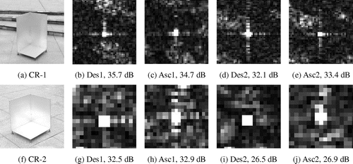
In order to assess the quality of the absolute geolocation ability of TSX high-resolution spotlight data, we use two trihedral CRs (as shown in Figures (a) and (f)). The size of CR-1 is 50 cm × 50 cm × 75 cm, and the size of CR-2 is 50 cm × 50 cm × 50 cm.
For TSX with a wavelength of λ = 3.1 cm, we calculate the theoretical peak radar cross-section (RCS) to be σ ≈ 38.7 and 34.2 dB for CR-1 and CR-2, respectively. In this study, both CRs were set up at the same ground position each time before the acquisition. The high RCS allows for a good sub-pixel positioning.
For assessing the geometric accuracy of the test data, the ground coordinates of both CRs were surveyed by differential GPS. For measuring the absolute position within the SAR image, the coordinate system has to be carefully chosen, otherwise continental drift will affect the results (Cong et al. Citation2012). Because the GPS positions are defined in a fixed tectonic plate system, such as ETRF89 for Europe, and the TSX-1/TDX-1 orbit is defined in the International Terrestrial Reference Frame (ITRF-2008) coordinates, offsets exist between these reference frames. Therefore, we use ITRF-2008 coordinates with similar epochs. The final 3D position accuracy reported by the GPS software was 1.4 cm horizontally and 4.7 cm vertically. However, the positional stability might not be optimal because the CRs had to be set up for each acquisition. We estimate the setup error to be less than 0.1 m, but probably in the centimeter range.
3. Experiment
3.1. Test site and TerraSAR-X image data-sets
We conducted our tests on the campus of Wuhan University. We acquired four TSX images in HS mode in single polarization. Two images were acquired on a descending orbit and the other two on an ascending orbit. The image parameters are summarized in Table .
Table 1. Basic parameters of acquired test data in HS mode.
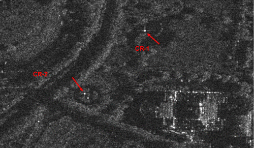
We mounted the corner reflectors in a flat square in Wuhan University as shown in Figure . This square with a broad view is suitable for GPS measurement because there are no high buildings or other obstacles nearby. Additionally, there are many existing survey control points made of steel nails, from which we chose two to locate the CRs and perform the GPS measurement. The horizontal distance of CR-1 and CR-2 is 133 m with the elevation difference of about 2 m. Because the square has a relatively large number of pedestrians, we had to move and mount the CRs every time before the acquisition, and hence the difference between the GPS antenna reference point and the CR’s phase center varied for each image.
Figure 1. Close-up of the CRs.
For the absolute location accuracy analysis of the TSX imagery, highly accurate coordinates of the corner reflectors were obtained by GPS observations. We measured the coordinates of the CRs with a dual frequency Leica GPS 1202 for more than 2 h with a sampling interval of 1 s. The high-precision GPS data processing software GAMIT/GLOBK developed by MIT was applied for the post processing. Three International GPS Service (IGS) reference stations including Wuhan (WUHN), Beijing (BJFS), and Shanghai (SHAO) were used to obtain coordinates under ITRF-2008 reference frame at TSX measurement epochs, which were consistent with the test images. The final 3D position accuracy reported by the GPS software was 1.4 cm horizontally and 4.7 cm vertically.
3.2. Sub-pixel location of the CRs
In order to assess the geolocation accuracy of the present test data, sub-pixel accuracy the locations of the CRs on the individual images were measured by oversampling. The amplitude images together with the RCS values in dB of each CR are shown in Figure . The measured RCS value of both CRs is close to the maximum theoretical RCS, except for that of CR-2 in image Des2 and Asc2, which may be due to a pointing error in the setup. In Figures (i) and (j), we can see that the background radiation in that area is very low, and the intensity of CRs is considerably higher.
Figure 2. Intensity of two CRs with different sizes in each image.
3.3. Single SAR image absolute geolocation
The 3 arc-second SRTM data is first employed for the SAR image geolocation. Then we use the target height derived from GPS measurement to retrieve the CR ground position. Comparison between the two geolocation accuracies is carried out below.
The height values obtained from the SRTM are in the World Geodetic System 1984/Earth Gravitational Model 1996 (WGS84/EGM96). The heights were transformed accordingly in order to compare the geolocation height with our GPS height, which is in the ITRF-2008 frame. The mean residual values and the Root Mean Square Error (RMSE) values of the 3D point residuals in Easting (E), Northing (N), and Height (H) as well as that of the displacement distances in horizontal and spatial are summarized in Tables and .
Table 2. Absolute geolocation accuracy of CR-1 using SRTM.
Table 3. Absolute geolocation accuracy of CR-2 using SRTM.
As shown in Tables and , there are large displacements in Easting, which is mainly due to range displacements. The error in range in this example is dominated by the height error of the SRTM data. We therefore tested the geolocation accuracy of a single image when using the height derived from the GPS measurement. The geolocation residual in Easting (E), Northing (N), and the Spatial distance of the point displacements are summarized in Tables and . In this case, we assume the Height residual as 0.
Table 4. Absolute geolocation accuracy of CR-1 using GPS height.
Table 5. Absolute geolocation accuracy of CR-2 using GPS height.
As shown in Tables and , the 3D localization accuracy evaluated by RMSE is about 0.6 m using GPS “true” height. This corresponds to the declared pixel localization accuracy of 1 m in TSX specification (Eineder et al. Citation2008). From the experiments above, the geolocation error is typically dominated by the DEM error. Assuming a “perfect” DEM could be obtained, as we did when using the GPS height in Tables and , a single SAR image can be located with an accuracy of a few decimeters. This accuracy could further be improved by taking additional information into consideration, such as the wet atmospheric delay and the Solid-Earth tides. However, outside of experimental setups, DEMs are not perfect and we need an alternative approach for high-accuracy geolocation. Using two or more SAR images in a stereo-configuration based on direct stereo SAR geolocation method, we can estimate the 3D position of the ground targets as shown in the following section.
3.4. Stereo SAR images absolute geolocation
For stereo point measurement, we test the combination of two ascending and two descending images, as well as the multi-orbit configuration comprising the four images. Corresponding point residuals can then be determined by comparison with the ground coordinate measurements. The mean residual values and the RMSE values of the 3D point residuals in Easting (E), Northing (N), and Height (H) as well as that of point displacement distances in horizontal and spatial directions are summarized in Tables and .
Table 6. Absolute geolocation accuracy of CR-1.
Table 7. Absolute geolocation accuracy of CR-2.
These residual values may be considered to represent the 3D mapping accuracy which is feasible from TSX stereo pairs and lead to the following analysis.
| (1) | In Northing, we reach very high accuracies of less than 5 cm and even sub-centimeter accuracies. The localization accuracy in this direction is dominated by errors in the azimuth direction. | ||||
| (2) | In Easting and Height, the accuracy is worse, because atmospheric effects and solid Earth tides are not taken into account. We only correct the dry atmosphere path delay with values taken from the TSX header. Nevertheless, we can generally achieve an accuracy of around 20 cm in the horizontal direction and clearly achieve sub-pixel geocoding accuracy in range and in azimuth. | ||||
| (3) | It seems we could reach an overall higher accuracy with CR-1, which might be due to the higher RCS and a better sub-pixel positioning accuracy, while the lower accuracies for CR-2 in Des2 and Asc2 are due to possible pointing errors of. | ||||
| (4) | The combination of four images leads to better and probably more stable results, although due to the design of our method, the error in the combined approach is influenced by the lower accuracy results, which may lead to a worse positioning accuracy than a combination of just two images. | ||||
4. Conclusions
For single image geolocation, the absolute 3D localization accuracy of TSX HS images could be less than 6 m using the SRTM DEM. For stereo SAR image geolocation, we can obtain an absolute 3D localization accuracy of less than 0.5 m. In both cases, the errors are dominated by errors in range, due to improper height estimations, atmospheric, and geodynamic effects. We demonstrated that an absolute 3D geolocation accuracy of less than 0.5 m using stereo SAR images can be obtained by relying on the information from the TSX header only, without correction for the wet atmosphere or geodynamic effects. This is better than the TerraSAR localization specification of 1 m (Eineder et al. Citation2008). Therefore, TSX data can be used to extract the geolocation of targets, and retrieve GCPs for ortho-rectification of remote sensing imagery. The results also indicate that for data fusion approaches, TSX can be used as the reference because of its high initial accuracy.
However, our experiments can be further optimized. The setup of the corner reflectors led to an error in positioning in the centimeter range, which is, as we can see from our results, in the error range and therefore not acceptable. It is therefore necessary to improve our experimental setup with stable reflectors in the future work.
Funding
This work was supported by the National Natural Science Foundation of China [grant number 61331016] and [grant number 41174120]. The TerraSAR-X data were provided by DLR via the LAN2245 Project.
Notes on contributors
Jinghui Wang is a postgraduate of State Key Laboratory of Information Engineering in Surveying, Mapping and Remote Sensing (LIESMARS), Wuhan University. Currently her research is devoted to the geolocation of high-resolution SAR images.
Timo Balz is Professor of LIESMARS, Wuhan University. His research focuses on radar interferometry, radargrammetry, radar image simulation, and high-performance computing.
Mingsheng Liao is Professor of LIESMARS, Wuhan University. He is mainly engaged in InSAR, POLinSAR, and their applications in topography, geological hazard monitoring, infrastructure security, etc.
References
- Balss, U., C. Gisinger, X. Cong, R. Brcic, P. Steigenberger, M. Eineder, R. Pail, and U. Hugentobler. 2013. “High Resolution Geodetic Earth Observation with TerraSAR-X: Correction Schemes and Validation.” Geoscience and Remote Sensing Symposium (IGARSS), 2013 IEEE International, Melbourne, Australia, IEEE Press, 4499–4502.
- Balz, T., L. Zhang, and M. Liao. 2013. “Direct Stereo Radargrammetric Processing Using Massively Parallel Processing.” ISPRS Journal of Photogrammetry and Remote Sensing 79 (5): 137–146.10.1016/j.isprsjprs.2013.02.014
- Brown, W. E.. 1981. “Applications of SEASAT SAR Digitally Corrected Imagery for Sea Ice Dynamics”. Geophys Union Spring Meeting, Baltimore, 25–29.
- Chen, E., Z. Li, Y. Lu, and X. Tian. 2010. “Constructing Geo-Location Models and Their Geo-Location Accuracy Evaluation of Three High Resolution Satellite SAR.” [ In Chinese.] Remote Sensing Information 32 (2): 43–48.
- Cong, X., U. Balss, M. Eineder, and T. Fritz. 2012. “Imaging Geodesy – Centimeter-level Ranging Accuracy with TerraSAR-X: An Update.” IEEE Geoscience and Remote Sensing Letters 9 (5): 948–952.10.1109/LGRS.2012.2187042
- Curlander, J. C. 1982. “Location of Spaceborne Sar Imagery.” IEEE Transactions on Geoscience and Remote Sensing 20 (3): 359–364.10.1109/TGRS.1982.350455
- Eineder, M., T. Fritz, J. Mittermayer, A. Roth, E. Boerner, and H. Breit. 2008. TerraSAR-X Ground Segment, Basic Product Specification Document. Oberpfaffenhofen, Germany: Cluster Applied Remote Sensing.
- Eineder, M., C. Minet, P. Steigenberger, X. Cong, and T. Fritz. 2011. “Imaging Geodesy – Toward Centimeter-level Ranging Accuracy with TerraSAR-X.” IEEE Transactions on Geoscience and Remote Sensing 49 (2): 661–671.10.1109/TGRS.2010.2060264
- Fritz, T. 2007. TerraSAR-X Ground Segment Level 1b Product Format Specification. Doc. TX-GS-DD-3307, Issue 1.3, 257.
- Raggam, H., K. Gutjahr, R. Perko, and M. Schardt. 2010. “Assessment of the Stereo-radargrammetric Mapping Potential of TerraSAR-X Multibeam Spotlight Data.” IEEE Transactions on Geoscience and Remote Sensing 48 (2): 971–977.
- Schubert, A., D. Small, M. Jehle, and E. Meier. 2012. “COSMO-SkyMed, TerraSAR-X, and RADARSAT-2 Geolocation Accuracy after Compensation for Earth-system Effects.” Geoscience and Remote Sensing Symposium (IGARSS), 2012 IEEE International, Munich, Germany, IEEE Press, 3301−3304.
- Schubert, A., M. Jehle, D. Small, and E. Meier. 2010. “Influence of Atmospheric Path Delay on the Absolute Geolocation Accuracy of TerraSAR-X High-Resolution Products.” IEEE Transactions on Geoscience and Remote Sensing 48 (2): 751–758.10.1109/TGRS.2009.2036252
- Wei, J., J. Zhang, Z. Zhao, and L. Pang. 2011. “High-Precisely Direct Geo-Location Method for Terrasar-X Image with Sparse GCPs.” [ In Chinese.] Science of Surveying and Mapping 36 (1): 58–60.
- Yoon, Y. T., M. Eineder, N. Yague-Martinez, and O. Montenbruck. 2009. “TerraSAR-X Precise Trajectory Estimation and Quality Assessment.” IEEE Transactions on Geoscience and Remote Sensing 47 (6): 1859–1868.10.1109/TGRS.2008.2006983
Appendix 1
Annotation of simple tropospheric (dry) and iononspheric models for corrected signal path delay are indicated in the TSX annotation file “GEOREF.xml” (Fritz, Citation2007).
The range timing correction of ionospheric path delay is extracted from:
<geoReference …><signalPropagationEffects>
<rangeDelay source=“IONO” modelVersion=“1.0” modelName=“averageTECU_5”>
<validityRangeMin>4.76998155348368289E−03</validityRangeMin>
<validityRangeMax>4.80190247904817118E−03</validityRangeMax>
<referencePoint>4.78594201626592747E−03</referencePoint>
<polynomialDegree>0</polynomialDegree>
<coefficient exponent=“0”>2.10492835461890730E−10</coefficient>
</rangeDelay>
The ionospheric range time correction is identical to the “coefficient”. Here in the example, Δτiono = 2.10492835461890730E−10 s. Then the ionospheric range path delay
can be calculated as
, where c is the light speed in vacuum.
The range timing correction of tropospheric path delay is extracted from:
<geoReference …><signalPropagationEffects>
<rangeDelay source=“ATMOS” modelVersion=“1.0” modelName=“hydrostatic”>
<validityRangeMin>4.76998155348368289E−03</validityRangeMin>
<validityRangeMax>4.80190247904817118E−03</validityRangeMax>
<referencePoint>4.78594201626592747E−03</referencePoint>
<polynomialDegree>0</polynomialDegree>
<coefficient exponent=“0”>2.23458957430599905E−08</coefficient>
</rangeDelay>
Here in the example, = 2.23458957430599905E−08 s. Then the tropospheric range path delay
can be calculated as
.