
Abstract
Applying remote sensing techniques to develop the retrieval models and further to obtain the spatiotemporal information of water quality parameters is necessary for understanding, managing, and protecting lake ecosystems. This study aimed to calibrate and validate the retrieval models for estimating the concentrations of chlorophyll a (CCHL), suspended particulate matter (CSPM), and dissolved organic carbon (CDOC) with the in situ hyperspectral measurements in Poyang Lake, China in 2010 and 2011. The model calibration and validation results indicated that: (1) for CCHL retrieval, significantly strong and moderate correlations existed between the measured and estimated values (with the correlation coefficient r = 0.92 and r = 0.76) using the exponential model and the three-band model, respectively, with biased estimation observed for the exponential model; (2) for retrieving CSPM, there was a strong correlation between the measured and estimated values (r = 0.95) using the exponential model; and (3) no significant correlation between measured and estimated CDOC values was found with our developed models. More work is needed to allow the water quality of Poyang Lake to be accurately and steadily estimated, especially for CCHL and CDOC.
1. Introduction
Lakes provide multiple benefits to society through commerce, esthetics, tourism, recreation, and biodiversity conservation (Jorgensen, Loffler, and Rast Citation2005; O’Sullivan and Reynolds Citation2005), and these provisions are greatly influenced by water quality. Therefore, applying remote sensing techniques to develop the retrieval models and further to obtain the spatiotemporal information of water quality parameters is necessary for understanding, managing, and protecting lake ecosystems. To date, several important water quality parameters can be estimated through remote sensing techniques, including: (1) phytoplankton, the biomass of which is generally derived from chlorophyll a (CHL) concentration; (2) suspended particulate matter (SPM), including suspended particulate inorganic matter (SPIM) and suspended particulate organic matter (SPOM); and (3) dissolved organic carbon (DOC), in which yellow substance (also known as color/chromophoric dissolved organic matter) is a dominant component (Ma et al. Citation2010).
Several types of multispectral (several spectral bands) or superspectral (tens of spectral bands) remote sensing data, such as Landsat (Allan et al. Citation2011; Brezonik, Menken, and Bauer Citation2005; Carpenter and Carpenter Citation1983), advanced spaceborne thermal emission and reflection radiometer (Kishino, Tanaka, and Ishizaka Citation2005; Nas et al. Citation2009; Volpe, Silvestri, and Marani Citation2011), moderate resolution imaging spectroradiometer (MODIS) (Giardino et al. Citation2010; Kilham and Roberts Citation2011; Song and ke Citation2015; Zhang et al. Citation2010), and medium-resolution imaging spectrometer (MERIS) (Doerffer and Schiller Citation2007; Odermatt, Giardino, and Heege Citation2010; Tang et al. Citation2009), have been employed to retrieve the aforementioned water quality parameters. These images generally perform well in retrieving water quality parameters; however, they also have several limitations. One limitation is their low spatial resolutions (more than several hundred meters) or long repeating cycles (more than ten days), and another very important one is their wide bandwidths (more than 10 nm) or small numbers of wavebands (several or tens of), which cannot accurately capture the spectral characteristics of water quality parameters (Dekker et al. Citation1992).
Hyperspectral (hundreds of spectral bands) remote sensing techniques can acquire near-continuous spectral information of the Earth’s surface, with a very narrow bandwidth (less than 10 nm) and a large number of wavebands (typically 200 or more) throughout the visible and infrared regions of electromagnetic spectrum (Govender, Chetty, and Bulcock Citation2007). Many studies have explored their potentials on water quality retrievals with different data sources, including in situ hyperspectral measurements (Sun, Li, and Wang Citation2009; Yacobi et al. Citation2011), and airborne (Kallio et al. Citation2001; Thiemann and Kaufmann Citation2002) or satellite hyperspectral images (Chen et al. Citation2011; Giardino et al. Citation2007). These studies indicated that hyperspectral remote sensing might overcome some limitations of multispectral and superspectral remote sensing techniques and have potentials for improving water quality estimations. However, the applications of airborne and satellite hyperspectral images were very limited due to data availability and/or affordability, and thus the in situ hyperspectral measurements were employed frequently.
Based on the data sources mentioned above, three kinds of models are employed for retrieving water quality parameters (Giardino et al. Citation2007; Ma et al. Citation2010): empirical, semi-empirical, and semi-analytical model. Semi-analytical models might be more suitable for different water bodies compared with empirical and semi-empirical ones due to their strict theories (Giardino et al. Citation2007; Ma et al. Citation2010). However, their applications are limited because of the difficulties or inaccuracies in obtaining model-driving parameters (Ma et al. Citation2010). Empirical and semi-empirical models are frequently applied currently. However, they do not have strict theoretical foundations, and their styles or coefficients are often region- and time-dependent due to the different optical properties at different water bodies or time periods. Therefore, empirical and semi-empirical models generally need to be calibrated or validated for a specific water body.
Poyang Lake is the currently largest freshwater lake in China, and some studies have been conducted to retrieve its water quality parameters during recent years, such as Chen et al. (Citation2007) employed in situ hyperspectral measurement to simulate TM and MERIS data and developed SPM retrieval models, Feng et al. (Citation2012) used MODIS data to observe long-term turbidity changes in this lake, and Wu et al. (Citation2013) compared different MODIS-based models for retrieving SPM. However, no unified model exists for SPM retrieval in Poyang Lake; when referring to chlorophyll, very few studies were focused on CHL retrieval, the empirical model developed by Feng et al. (Citation2015) could not be used in highly turbid area in northern Poyang Lake. Huang, Gao, and Zhang (Citation2015) combined artificial neural network and clustering techniques to predict CHL separately, as no simple and common model has yet been achieved. Since the results from these studies are limited to exploring remote sensing-based methods for retrieving the water quality parameters of this huge and dynamic lake system, this study aims to calibrate and validate the retrieval models for estimating the concentrations of CHL (CCHL), SPM (CSPM), and DOC (CDOC) with the in situ hyperspectral measurements in Poyang Lake, which may lay foundations for retrieval models selection in the airborne or satellite hyperspectral image-based water quality parameter estimations.
2. Materials and methods
2.1. Study area
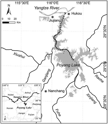
Poyang Lake (115°47′–116°45′E, 28°22′–29°45′N) is located on the southern bank of the middle Yangtze River (Figure ). It is a seasonal lake with the fluctuation of water level, and its size fluctuates from less than 1000 km2 in dry season to about 4000 km2 in rainy season. The lake receives water from five rivers (Raohe River, Xinjiang River, Fuhe River, Ganjiang River, and Xiushui River) and drains into the Yangtze River through a channel in the north.
Figure 1. Location of Poyang Lake and sampling sites in 2010 (black dots) and 2011 (black crosses).
With the increasing population and intensive economic activities within Poyang Basin during recent decades, the water quality of Poyang Lake shows a clear downwards trend due to agricultural chemical inputs as well as industrial and waste discharges (Deng et al. Citation2011; Zhen et al. Citation2011). Although the average CCHL is low in general for the whole lake, eutrophication was found in some regions (Wan and Yan Citation2007; Wang et al. Citation2007). Suspended sediment (or SPIM) is one of dominant factors affecting the water quality of Poyang Lake (Jin, Liu, and Tu Citation1990), and its concentration fluctuates largely due to the sand discharges from the five rivers, the water backflows from the Yangtze River, and the dredging activities (Cui, Wu, and Liu Citation2009; Cui, Zhai, and Wu Citation2013; Wu et al. Citation2007). Such water quality degradation greatly and negatively impacts this lake ecosystem.
2.2. Fieldwork
Fieldwork was carried out on 16–18 October 2010 and 8–10 August 2011, and 85 sampling sites (47 in 2010 and 38 in 2011) were distributed along main channel due to low water levels (Figure ). At each sampling site, the wind velocity and direction were measured using a wind velocity indicator, the geographical coordinate was recorded using a global positioning system receiver (Garmin Ltd.), the spectra were measured with a portable ASD Fieldspec Pro Dual VNIR spectrometer (ASD Inc.), and about 1500 ml of surface water was collected from around 0–50-cm water depth and was kept in a refrigerator for less than 10 h before the measurements of CCHL, CSPM, and CDOC were made in the laboratory.
2.3. Spectral measurement
The ASD Fieldspec Pro Dual VNIR spectrometer used in this study has a spectral range of 350–1050 nm with a spectral sample interval of 1.4 nm. Prior to the field campaign, the absolute radiance calibrations of two spectrometer detectors were performed. At each sampling site, the measurements were carried out following the NASA protocol (Mueller, Fargion, and McClain Citation2003) and the steps described by Ma, Tang, and Dai (Citation2006) and Ma et al. (Citation2010): (1) the radiance from a 25 × 25 cm gray diffuse reflectance standard with 25% reflectivity was measured; (2) the radiances from the water and sky were measured synchronously using two detectors; (3) the above-mentioned two steps were repeated once; and (4) the radiance from the reflectance standard was measured again.
2.4. Constituent concentration measurement
The concentrations of the main water constituents were measured according to the investigation criteria about the lakes of China (Huang Citation1999). A spectrophotometric determination method was used to measure the CCHL: (1) each water sample was filtered using a Whatman GF/F glass fiber filter with a 0.45 μm pore size, and acetone was used to extract chlorophyll a from the filtered sample; (2) the sample was read before and after its acidification using a UV2401 spectrophotofluorometer (Shimadzu Corp.); and (3) the CCHL value of the water sample was calculated by comparing the readings with a known standard (Duan et al. Citation2010a). The CSPM was measured gravimetrically: (1) the water sample was filtered using a pre-weighted Whatman GF/F glass fiber filter with a 0.45 μm pore size; (2) the filter was dried for 2 h at 110 °C and reweighed after cooling to room temperature; and (3) the CSPM was calculated by dividing the difference in weight before and after filtering by the water sample volume (Ma, Tang, and Dai Citation2006a). A Model 1020 Total Organic Carbon (TOC) Analyzer (O. I. Corp.) was used to measure the CDOC after the water sample was filtered using a Whatman GF/F glass fiber filter with a 0.45 μm pore size (Ma et al. Citation2006a).
2.5. Remote sensing reflectance calculation and pre-processing
The abnormal radiance measurements from the gray diffuse reflectance standard, water, and sky were removed considering their spectral characteristics. The remote sensing reflectance at each sampling site was then calculated using the remaining measurements with the following equation (Ma et al. Citation2006a; Ma et al. Citation2010):(1)
where Rrs (sr−1) is the remote sensing reflectance of water body; Lw, Lsky, and Lp (W·m−2·sr−1) are the mean measured radiances from water, sky, and gray diffuse reflectance standard; ρw indicates the water–air interface reflectance rate, and its value is 0.022, 0.025, and 0.028 for a wind velocity of 0, 5, and 10 m/s, respectively; ρp is the reflectance rate of gra diffuse reflectance standard, and its value is 0.25; and π (sr) is the solid angle.
The first-order derivative of Rrs might improve water quality retrieval (Ma et al. Citation2010), and it was derived with the following equation:
(2)
where (i) (sr−1/nm), Rrs(i) and λ(i) (nm) are the first-order derivative, Rrs, and wavelength at band i, respectively.
Only the Rrs and at the wavelengths of 400–900 nm were employed for model calibration and validation. The samples with incorrect spectrum (non-typical Case-II water spectrum) or water constituent concentration measurement (negative value) were removed from the following statistics and analysis.
2.6. Model calibration
The data-set in 2010 was employed for model calibrations. The CCHL, CSPM, and CDOC values of remaining water samples were statistically described, and the correlations among them were analyzed. The spectra of Rrs and were visualized and analyzed. The correlation analysis of Rrs and
against CCHL, CSPM, and CDOC was then implemented, respectively, in order to find the potential bands for model calibrations. Finally, in order to find the best-fitting model for retrieving water quality parameters, the widely used simple linear (y = a + bx), quadratic (y = a + bx + cx2), power (y = axb), and exponential (y = aebx) models of CCHL, CSPM, and CDOC against a single potential band (including Rrs and
) or band combinations were calibrated with the least squares technique; while two- (Equation (Equation3
(3) )) and three-band (Equation (Equation4
(4) )) models (Chen et al. Citation2011; Duan et al. Citation2010b; Gilerson et al. Citation2010; Gitelson et al. Citation2009; Gurlin, Gitelson, and Moses Citation2011) were especially calibrated for CCHL due to their wide and successful applications in many cases. The determination coefficients (R2) and estimated standard errors (SE) of all tested regression models were compared to determine the best-fitting one of each water quality parameter.
(3)
(4)
where Rrs (λ1), Rrs (λ2), and Rrs (λ1) are the reflectance values at around 670, 710, and 750 nm, respectively (Gitelson et al. Citation2009).
2.7. Model validation
Two-step model validations were carried out for the best-fitting model of each water quality parameter. The first step was leave-one-out cross-validation (LOOCV) with the data-set in 2010. LOOCV was proposed by Craven and Wahba (Citation1978) and is considered as an almost unbiased estimator of model validation (Cawley and Talbot Citation2004) with the following process: (1) one sample was selected as a validation datum and removed from total n samples; (2) the remaining n-1 samples were employed as training data to fit a regression model with the same form as above-developed best-fitting model, using the least squares technique; (3) the fitted regression model was then used to estimate the water quality parameter value of that excluded sample; (4) the aforementioned steps (1–3) were repeated until each sample was selected once, and, thus, the water quality parameter values of all water samples were estimated; and (5) the correlation coefficient (r) between the measured and estimated values of all water samples was calculated to assess model accuracy, while the null hypotheses that the slope and intercept of the linear regression line between measured and estimated values were equal to 1 and 0, were tested, respectively, to assess estimation bias. The second step was an independent validation. To each water quality parameter, the best-fitting model was applied to the data-set in 2011 to estimate the values of remaining water samples from Rrs or , and the r value between the measured and estimated values was calculated to assess model accuracy.
3. Results
3.1. Measurement analysis
Thirteen samples in 2010 were removed from the following statistics and analysis, one with a negative CCHL value and twelve without the typical spectral property of Case-II water. Ten of the removed samples were collected on 16 October 2010, when the waves caused by high wind velocities (>5 m/s) greatly affected the accuracies of spectral measurements. Four samples in 2011 were removed because they missed the typical spectral property of Case-II water.
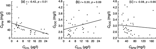
The statistical results for CCHL, CSPM, and CDOC of the remaining 34 water samples in 2010 are shown in Table . StdDev means standard deviation and CoeVar is coefficient of variation. The results showed that the CSPM had high values with moderate variation (average CSPM = 54.20 mg/l, CoeVar = 60.54%), the CCHL was low with high variation (average CCHL = 9.42 μg/l, CoeVar = 70.28%), and the CDOC was low with low variation (average CDOC = 3.00 mg/l, CoeVar = 18.33%). The correlation analysis (Figure ) indicated a significantly weak and negative relation between CSPM and CCHL and a non-significant correlation between CDOC and CCHL as well as between CDOC and CSPM at a significance level of 0.05.
Table 1. Water quality parameters statistics of 34 samples in 2010.
Figure 2. Correlations between the concentrations of different water quality parameters of 34 water samples in 2010. (a) CCHL and CSPM; (b) CCHL and CDOC; (c) CSPM and CDOC.
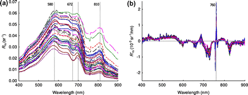
The Rrs spectra in 2010 (Figure (a)) showed a typical spectral characteristic of Case-II water: the Rrs increased with increasing wavelength over 400–550 nm, and it was much higher than 0 in the near-infrared region; while there were two SPM reflectance peaks at around 580 and 810 nm as well as an absorption peak and a reflectance peak of CHL at about 672 and 700 nm. The (Figure (b)) generally ranged from −0.001 to 0.001 sr−1/nm, but it had values with large fluctuation at the wavelengths around 760 nm.
Figure 3. Spectra of remote sensing reflectance (Rrs) (a) and its first-order derivative () (b) over 400–900 nm at the 34 sampling sites in 2010.
3.2. Retrieval models of water quality parameters
The correlation analysis between CCHL and Rrs (Figure (a)) showed that the correlation coefficient obtained the lowest value (r = −0.31, p = 0.074) at the wavelength of 900 nm and was about 0.59−0.60 at the wavelengths over 666–682 nm; while the highest correlation between CCHL and (r = 0.88, p < 0.001) was observed at the wavelengths of 681 and 692 nm (Figure (b)).
Figure 4. Model calibration results for estimating CCHL with 2010 data-set (n = 34). (a) correlation coefficient between CCHL and Rrs; (b) correlation coefficient between CCHL and ; (c) model of CCHL against
(681); (d) LOOCV result of (c); (e) the best-fitting three-band model for CCHL;(f) LOOCV result of (e).
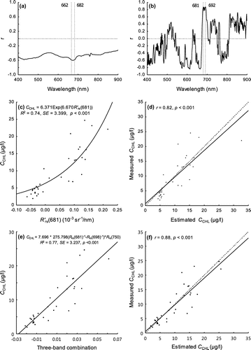
The exponential model of at 681 nm obtained the best fitting of all tested simple models for retrieving CCHL, and it explained 74% of the variation of CCHL with an SE of 3.399 μg/l (Figure (c)). The LOOCV result showed a significantly strong correlation between the measured and estimated CCHL values (r = 0.82, p < 0.001) at a significance level of 0.05 in Figure (d), where the solid line is the regression line between the estimated and measured values, and the dashed line is 1:1 line. The null hypotheses tests of the intercept being equal to 0 and the slope being equal to 1 for the regression line between the measured and estimated values indicated that the intercept and slope were not significantly different from 0 (t = 0.532, df = 32, p = 0.599) and 1 (t = −0.902, df = 32, p = 0.374) at a significance level of 0.05, respectively.
The three-band model using 681, 698, and 750 nm had the best fitting result among all tested two- and three-band models for retrieving CCHL, and it explained 77% of the variation of CCHL with an SE of 3.237 μg/l (Figure (e)). Its LOOCV result indicated a significantly strong correlation between the measured and estimated CCHL values (r = 0.88, p < 0.001) (Figure (f)). The null hypotheses tests showed that the intercept and slope were not significantly different from 0 (t = 0.504, df = 32, p = 0.618) and 1 (t = −0.881, df = 32, p = 0.385), respectively. Compared with the exponential model of at 681 nm, the three-band model obtained a better result for estimating CCHL.
There existed significantly positive correlations between CSPM and Rrs (r > 0.6) over the wavelengths of 400–900 nm, and the strong correlations (r ≥ 0.85) were observed between 714 and 900 nm (Figure (a)). The greatest positive and negative correlations between CSPM and were found at 775 nm (r = 0.87, p < 0.001) and 880 nm (r = −0.91, p < 0.001), respectively (Figure (b)).
Figure 5. Model calibration results for estimating CSPM with 2010 data-set (n = 34). (a) correlation coefficient between CSPM and Rrs; (b) correlation coefficient between CSPM and ; (c) model of CSPM against Rrs(775); (d) LOOCV result.
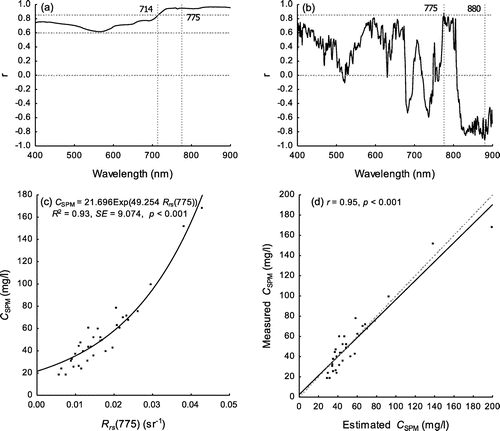
The exponential model of Rrs at 775 nm best explained the variation of CSPM (R2 = 0.93, SE = 9.074 mg/l, p < 0.001) (Figure (c)). The LOOCV result showed a significantly strong correlation between the measured and estimated CSPM values (r = 0.95, p < 0.001) (Figure (d)). The results of the null hypothesis tests showed that the intercept and slope were not significantly different from 0 (t = 0.771, df = 32, p = 0.482) and 1 (t = −1.151, df = 32, p = 0.258), respectively.
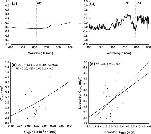
The correlation between CDOC and Rrs was very low over 400–900 nm, and the highest one was found at 616 nm but not significant at a significance level of 0.05 (r = −0.26, p = 0.131) (Figure (a)). The highest significantly positive and negative correlations between CDOC and were observed at the wavelengths of 745 nm (r = 0.44, p = 0.010) and 791 nm (r = −0.37, p = 0.031), respectively (Figure (b)). The exponential model of
at the wavelength of 745 nm had the best fitting of all tested simple models for retrieving CDOC; however, it could only explain 20% of the variation of CDOC with an SE of 0.501 mg/l (Figure (c)). The LOOCV result indicated a non-significant correlation (r = 0.33, p = 0.057) between the measured and estimated values (Figure (d)).
Figure 6. Model calibration results for estimating CDOC with 2010 data-set (n = 34). (a) correlation coefficient between CDOC and Rrs; (b) correlation coefficient between CSPM and ; (c) model of CDOC against
(745); (d) LOOCV result.
3.3. Estimation of water constituent concentration
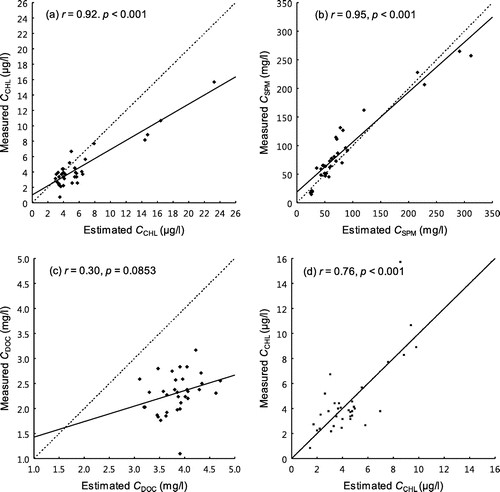
The best-fitting simple models were applied to the remaining 34 water samples in 2011 to estimate the CCHL, CSPM, and CDOC values, respectively. A significantly strong correlation was observed between the measured and estimated values for CCHL (r = 0.92, p < 0.001) (Figure (a)) and CSPM (r = 0.95, p < 0.001) (Figure (b)); however, a clear biased estimation was observed for CCHL; no significant correlation was found between the measured and estimated CDOC values (r = 0.30, p = 0.0853) (Figure (c)). The validation result of three-band model of 681, 698, and 750 nm showed a significantly moderate correlation between the measured and estimated CCHL values (r = 0.76, p < 0.001), and the estimation was unbiased (a = −0.001, b = 1.000) (Figure (d)).
Figure 7. Validations of the best-fitting regression models for 2011 data-set (n = 34). (a) simple model for CCHL; (b) simple model for CSPM; (c) simple model for CDOC; (d) three-band model for CCHL.
4. Discussion
4.1. Water constituent concentration in Poyang Lake
In this study, we found that the CSPM (average CSPM = 54.20 mg/l) was much higher when compared with CCHL (average CCHL = 9.42 μg/l) and CDOC (average CDOC = 3.00 mg/l); meanwhile, the measured CCHL values (average CCHL = 9.42 μg/l, maximum CCHL = 24.65 μg/l) indicated that the lake was close to a eutrophic status as a whole. Several studies (Wan and Yan Citation2007; Wang et al. Citation2007) showed that eutrophication occurred at some regions of Poyang Lake, where the flow velocities were slow. These results together indicated that Poyang Lake would possibly face the same eutrophication problem as many other lakes in the world.
We observed that there was a significantly negative but weak correlation between the CSPM and CCHL values (r = −0.42, p = 0.01) at a significance level of 0.05. Such relation indicated that SPM in Poyang Lake was not dominated by the degradation production of phytoplankton but from land-based sources or sediment resuspension. No significant correlation between CDOC and CCHL (r = 0.30, p = 0.09) revealed that DOC was also not dominated by the degradation production of phytoplankton and possibly came from agricultural chemical inputs or industrial and waste discharges (Deng et al. Citation2011; Zhen et al. Citation2011).
4.2. Characteristics of water quality parameters in Poyang Lake
Generally, two CHL absorption peaks exist around the spectral ranges over 430–450 nm and 650–700 nm for the Case-II waters (Ma et al. Citation2006b); such characteristic was confirmed by the case of Poyang Lake, in which one inconspicuous and one clear CHL absorption peaks were observed at the wavelengths of 439 and 678 nm, respectively (Wu et al. Citation2011). This absorption characteristic of CHL could explain why most of the potential bands for retrieving CCHL were found at 666–682 nm (Rrs) and 681–692 nm in this study. Such a result is coincident with that found in Taihu Lake and Chagan Lake (Ma et al. Citation2010; Yunlin Zhang et al. Citation2009) and the Pearl River Estuary (Xing et al. Citation2008) in China, as well as the Geist and Morse Reservoirs in Indiana (Randolph et al. Citation2008). However, it is different from the result obtained by Wang et al. (Citation2007), who found that the potential bands for CCHL estimation appeared at 652 and 774 nm in Poyang Lake. We could not compare such difference, because they only employed nine samples and the model estimation accuracy are much lower (R2 = 0.42–0.43), while the model is not applicable to another date.
We found that the correlation between CCHL and Rrs was weak (absolute value of r ≤ 0.6) in this study, which confirms that a single original reflectance band has limitation and is not suitable for CCHL estimation (Ma et al. Citation2010). In this study, we found that the exponential model of at 681 nm explained 74% of the variation of CCHL, which indicated that the spectral derivative method can enhance CHL absorption features (CLOUTIS Citation1996) and resulted in a better CCHL estimation. Such a result is similar to that from a controlled experiment by Rundquist et al. (Citation1996) as well as from Taihu Lake and Chaohu Lake in China (Ma et al. Citation2010), which together indicated the potential of the
at around 690 nm for retrieving CCHL in different types of lakes.
Recently, some studies reported that the three-band model could improve the CCHL estimation in different water bodies, such as Taihu Lake (Li et al. Citation2012), Chagan Lake (Duan et al. Citation2010a), and Pearl River Estuary (Chen et al. Citation2011) in China, the Dnieper River and Taganrog Bay in Russia (Moses et al. Citation2009a, Citationb) as well as the Fremont State Lakes in USA (Gitelson et al. Citation2009; Gilerson et al. Citation2010). In our study, the three-band model explained 77% of the variation of CCHL and performed better than the exponential model of , which confirmed the potential of three-band model for retrieving CCHL. However, the estimation accuracy of the three-band model calibrated in our study was lower than or similar as that of most of these studies. Such a low estimation accuracy could be caused by the fact that the spectral signal of CHL is masked by that of SPIM due to lower CCHL and higher CSPIM in Poyang Lake; therefore, the limited three-band model needs to be improved further for accurately retrieving CCHL, especially for turbid water bodies such as Poyang Lake.
For Case-II waters, the absorption and backscattering coefficients of CHL, SPM, and DOC affect water-leaving radiance, which can be captured by a remote sensing sensor and used for retrieving water quality parameters (Kirk Citation1994; Ma et al. Citation2006a). The absorption coefficients of CHL, SPM, and DOC are almost 0 at the near-infrared wavelengths, especially for water bodies with low CCHL, and, thus, the water-leaving reflectance is dominated by the backscattering coefficient of SPM at these wavelengths in Case-II waters (Doxaran, Cherukuru, and Lavender Citation2006; Ma et al. Citation2010). These inherent optical properties of Case-II waters result in the significantly strong correlations between CSPM and Rrs over 714–900 nm observed in this study, which confirms that the near-infrared bands have the most potential for retrieving CSPM reported in many studies (Ma et al. Citation2009; Onderka and Pekárová Citation2008; Wang and Lu Citation2010).
Although the near-infrared bands have the most potential for retrieving CSPM, existing models have different types, inputting bands or accuracies. For example, Kallio et al. (Citation2001) employed linear models for estimating the CSPM values of 11 lakes in Finland (band = 705–714 nm, R2 = 0.82–0.91), and Ma et al. (Citation2010) developed linear models (band = 828 nm, R2 = 0.90; band = 788 nm, R2 = 0.77) and power models (band = 804 nm, R2 = 0.83; band = 760 nm, R2 = 0.57) for Taihu Lake as well as an exponential model (band = 722 nm, R2 = 0.86) for Shitoukoumen Reservoir in China. Compared with these models, the best-fitting model for retrieving CSPM calibrated in this study (band = 775 nm, R2 = 0.93) had a higher estimation accuracy. In addition, the differences of model styles or inputting bands could be explained by the different water constituents of different water bodies or different time periods. Therefore, it is important to further evaluate the retrieval model robustness for CSPM.
In this study, we also found that the correlation between CDOC and Rrs was very low over 400–900 nm, while the correlation between CDOC and was also weak, which indicates that the model with a single band is not suitable for CDOC retrieval. Such a result is similar to that found in Taihu Lake (Ma et al. Citation2010), in which the Rrs and
could only explain 39% and 43% of the variation of CDOC, respectively. Such a low estimation accuracy could be explained by two factors: one is that DOC has no clear spectral characteristics, while the strong absorption bands for DOC in the blue region of spectrum were also the strong absorption bands for CHL and SPM; and the other is that the absorption of DOC within strong absorption bands is further masked by those of CHL and SPM due to their high concentrations in Case-II waters (Ma et al. Citation2010). It is a big challenge to retrieve CDOC from very weak water-leaving radiance due to the low concentration and spectral characteristics of DOC.
4.3. Implications and limitations
Our results generally support the past research on in situ hyperspectral data-based CCHL, CSPM, and CDOC retrievals, and they might be applicable to other water bodies which have similar optical properties as Poyang Lake. Meanwhile, airborne and satellite hyperspectral images have great potentials for estimating some water quality parameters over large areas, and the models developed in this study could be applied to the hyperspectral images and provide methodological foundations for their applications in retrieving water quality parameters.
Since our results were only based on two-time period data collections along the main channel, and they still have spatial and temporal limitations unavoidably. Poyang Lake is a naturally dynamic system with large seasonal or yearly fluctuations in the water level and area; meanwhile, it is also suffering from serious environmental impacts caused by increasing population and intensive economic activities within its watershed. These natural and anthropogenic factors result in a great spatial and temporal heterogeneity of water constituents in this lake. However, most of the water quality retrieval models developed in this and other studies are empirical or semi-empirical, and they are very preliminary and often region- and time-dependent due to the different water constituents at different regions or at different time periods. More studies should be carried out to validate and improve these existing models or to develop new models to allow the water quality of Poyang Lake to be accurately and steadily estimated by remote sensing techniques.
5. Conclusions
The in situ hyperspectral measurement-based retrieval models for CSPM, CCHL, and CDOC in Poyang Lake were calibrated and validated. The main results are summarized as follows:
| (1) | The three-band model of 681, 698, and 750 nm obtained the best result for retrieving CCHL with a moderate accuracy, showing the potential of this model for CCHL retrieval in turbid water body. | ||||
| (2) | CSPM can be well estimated with a high accuracy using an exponential model of Rrs at the infrared band of 775 nm. | ||||
| (3) | CDOC can be best explained by the exponential model of | ||||
More work should be carried out in the future to improve the existing models or to develop new models for accurately and steadily estimating the water quality of Poyang Lake, especially for CCHL and CDOC.
Funding
This study was supported by the Forestry Non-Profit Industry Scientific Research Special Project “The Research of Ecosystem Service and Evaluation Techniques of Coastal Wetlands, China” [grant number 201404305].
Notes on contributors
Fangyuan Chen is currently a PhD candidate in Wuhan University. His main research interests include remote sensing of environment and GIS applications.
Di Xiao is currently an undergraduate student in Wuhan University. Her research focuses on remote sensing of inland lakes.
Zhuochao Li received his master’s degree from Wuhan University. His current research interest is remote sensing-based chlorophyll monitoring for inland lakes.
References
- Allan, M. G., D. P. Hamilton, B. J. Hicks, and L. Brabyn. 2011. “Landsat Remote Sensing of Chlorophyll a Concentrations in Central North Island Lakes of New Zealand.” International Journal of Remote Sensing 32 (7): 2037–2055.10.1080/01431161003645840
- Brezonik, P., K. D. Menken, and M. Bauer. 2005. “Landsat-based Remote Sensing of Lake Water Quality Characteristics, Including Chlorophyll and Colored Dissolved Organic Matter (CDOM).” Lake and Reservoir Management 21 (4): 373–382.10.1080/07438140509354442
- Carpenter, D. J., and S. M. Carpenter. 1983. “Modeling Inland Water Quality Using Landsat Data.” Remote Sensing of Environment 13 (4): 345–352.10.1016/0034-4257(83)90035-4
- Cawley, G. C., and N. L. C. Talbot. 2004. “Fast Exact Leave-one-out Cross-validation of Sparse Least-squares Support Vector Machines.” Neural Networks 17 (10): 1467–1475.10.1016/j.neunet.2004.07.002
- Chen, S., L. Fang, H. Li, W. Chen, and W. Huang. 2011. “Evaluation of a Three-band Model for Estimating Chlorophyll-a Concentration in Tidal Reaches of the Pearl River Estuary, China.” ISPRS Journal of Photogrammetry and Remote Sensing 66 (3): 356–364.10.1016/j.isprsjprs.2011.01.004
- Chen, X., Z. Wu, L. Tian, L. Chen, and Y. Ye. 2007. “Inversion Model for Dynamic Monitoring of Suspended Sediment: A Case Study on Poyang Lake.” [ In Chinese.] Science & Technology Review 25 (6): 19–22.
- CLOUTIS, E. A. 1996. “Hyperspectral Geological Remote Sensing: Evaluation of Analytical Techniques.” International Journal of Remote Sensing 17 (12): 2215–2242.10.1080/01431169608948770
- Craven, P., and G. Wahba. 1978. “Smoothing Noisy Data with Spline Functions: Estimating the Correct Degree of Smoothing by the Method of Generalized Cross-validation.” Numerische Mathematik 31 (4): 377–403.10.1007/BF01404567
- Cui, L., G. Wu, and Y. Liu. 2009. “Monitoring the Impact of Backflow and Dredging on Water Clarity Using MODIS Images of Poyang Lake, China.” Hydrological Processes 23 (2): 342–350.10.1002/hyp.v23:2
- Cui, L., Y. Zhai, and G. Wu. 2013. “Dredging Being Moved Southward Enlarges the Impacted Region in Poyang Lake – The Evidences from Multi-remote Sensing Images.” [ In Chinese.] Acta Ecologica Sinica 33 (11): 3520–3525.
- Dekker, A. G., T. J. Malthus, M. M. Wijnen, and E. Seyhan. 1992. “Remote Sensing as a Tool for Assessing Water Quality in Loosdrecht lakes.” Hydrobiologia 233 (1): 137–159.10.1007/BF00016102
- Deng, X., Y. Zhao, F. Wu, Y. Lin, Q. Lu, and J. Dai. 2011. “Analysis of the Trade-off Between Economic Growth and the Reduction of Nitrogen and Phosphorus Emissions in the Poyang Lake Watershed, China.” Ecological Modelling 222 (2): 330–336.10.1016/j.ecolmodel.2010.08.032
- Doerffer, R., and H. Schiller. 2007. “The MERIS Case 2 Water Algorithm.” International Journal of Remote Sensing 28 (3): 517–535.10.1080/01431160600821127
- Doxaran, D., N. Cherukuru, and S. J. Lavender. 2006. “Apparent and Inherent Optical Properties of Turbid Estuarine Waters: Measurements, Empirical Quantification Relationships, and Modeling.” Applied Optics 45 (10): 2310–2324.10.1364/AO.45.002310
- Duan, H. T., R. H. Ma, J. P. Xu, Y. Z. Zhang, and B. Zhang. 2010a. “Comparison of Different Semi-empirical aLgorithms to Estimate Chlorophyll-a Concentration in Inland Lake Water.” Environmental Monitoring and Assessment 170 (1–4): 231–244.10.1007/s10661-009-1228-7
- Duan, H. T., R. H. Ma, Y. Z. Zhang, S. A. Loiselle, J. P. Xu, C. L. Zhao, L. Zhou, and L. L. Shang. 2010b. “A New Three-band Algorithm For Estimating Chlorophyll Concentrations In Turbid Inland Lakes.” Environmental Research Letters 5 (4): 044009.10.1088/1748-9326/5/4/044009
- Feng, L., C. Hu, X. Chen, L. Tian, and L. Chen. 2012. “Human Induced Turbidity Changes in Poyang Lake between 2000 and 2010: Observations from MODIS.” Journal of Geophysical Research: Oceans 117 (C7): C07006.
- Feng, L., C. M. Hu, X. X. Han, X. L. Chen, and L. Qi. 2015. “Long-term Distribution Patterns of Chlorophyll-a Concentration in China’s Largest Freshwater Lake: MERIS Full-resolution Observations with a Practical Approach.” Remote Sensing 7 (1): 275–299. doi:10.3390/rs70100275.
- Giardino, C., V. E. Brando, A. G. Dekker, N. Strömbeck, and G. Candiani. 2007. “Assessment of Water Quality in Lake Garda (Italy) Using Hyperion.” Remote Sensing of Environment 109 (2): 183–195.10.1016/j.rse.2006.12.017
- Giardino, C., M. Bresciani, P. Villa, and A. Martinelli. 2010. “Application of Remote Sensing in Water Resource Management: The Case Study of Lake Trasimeno, Italy.” Water Resources Management 24 (14): 3885–3899.10.1007/s11269-010-9639-3
- Gitelson, A. A., D. Gurlin, W. J. Moses, and T. Barrow. 2009. “A Bio-optical Algorithm for the Remote Estimation of the Chlorophyll- a Concentration in Case 2 Waters.” Environmental Research Letters 4 (4): 045003.10.1088/1748-9326/4/4/045003
- Gilerson, A. A., A. A. Gitelson, J. Zhou, D. Gurlin, W. Moses, I. Ioannou, and S. A. Ahmed. 2010. “Algorithms for Remote Estimation of Chlorophyll-a in Coastal and Inland Waters Using Red and Near Infrared Bands.” Optics Express 18 (23): 24109–24125.10.1364/OE.18.024109
- Govender, M., K. Chetty, and H. Bulcock. 2007. “A Review of Hyperspectral Remote Sensing and Its Application in Vegetation and Water Resource Studies.” Water SA 33 (2): 145–151.
- Gurlin, D., A. A. Gitelson, and W. J. Moses. 2011. “Remote Estimation of Chl-a Concentration in Turbid Productive Waters – Return to a Simple Two-band NIR-Red Model?” Remote Sensing of Environment 115 (12): 3479–3490. doi:10.1016/j.rse.2011.08.011.
- Huang, J. C., J. F. Gao, and Y. J. Zhang. 2015. “Combination of Artificial Neural Network and Clustering Techniques for Predicting Phytoplankton Biomass of Lake Poyang, China.” Limnology 16 (3): 179–191. doi:10.1007/s10201-015-0454-7.
- Huang, X. 1999. Eco-Investigation, Observation and Analysis of Lakes. [ In Chinese.] Beijing: Standard Press of China.
- Jin, X., H. Liu, and Q. Tu. 1990. Eutrophication of Lakes in China. [ In Chinese.] Beijing: Chinese Environment Science Press.
- Jorgensen, S. E., H. Loffler, W. Rast, and M. Straskraba. 2005. Lake and Reservoir Management, Volume 54 (Developments in Water Science). Amsterdam: Elsevier Publishers.
- Kallio, K., T. Kutser, T. Hannonen, S. Koponen, J. Pulliainen, J. Vepsäläinen, and T. Pyhälahti. 2001. “Retrieval of Water Quality from Airborne Imaging Spectrometry of Various Lake Types in Different Seasons.” Science of The Total Environment 268 (1-3): 59–77.10.1016/S0048-9697(00)00685-9
- Kilham, N. E., and D. Roberts. 2011. “Amazon River Time Series of Surface Sediment Concentration from MODIS.” International Journal of Remote Sensing 32 (10): 2659–2679.10.1080/01431161003713044
- Kirk, J. T. O. 1994. Light and Photosynthesis in Aquatic Ecosystems. New York: Cambridge University Press.10.1017/CBO9780511623370
- Kishino, M., A. Tanaka, and J. Ishizaka. 2005. “Retrieval of Chlorophyll a, Suspended Solids, and Colored Dissolved Organic Matter in Tokyo Bay Using ASTER Data.” Remote Sensing of Environment 99 (1–2): 66–74.10.1016/j.rse.2005.05.016
- Li, Y. M., Q. Wang, C. Q. Wu, S. H. Zhao, X. Xu, Y. F. Wang, and C. C. Huang. 2012. “Estimation of Chlorophyll a Concentration Using NIR/Red Bands of MERIS and Classification Procedure in Inland Turbid Water.” IEEE Transactions on Geoscience and Remote Sensing 50 (3): 988–997.10.1109/TGRS.2011.2163199
- Ma, R., H. Duan, J. Tang, and Z. Chen. 2010. Remote Sensing of Lake Water Environment. [ In Chinese.] Beijing: Science Press.
- Ma, R., J. Tang, and J. Dai. 2006a. “Bio-Optical Model with Optimal Parameter Suitable for Taihu Lake in Water Colour Remote Sensing.” International Journal of Remote Sensing 27 (19): 4305–4328.10.1080/01431160600857428
- Ma, R. H., J. Tang, J. Dai, Y. Zhang, and Q. Song. 2006b. “Absorption and Scattering Properties of Water Body in Taihu Lake, China: Absorption.” International Journal of Remote Sensing 27 (19): 4277–4304.10.1080/01431160600851835
- Ma, R., J. Tang, H. Duan, and D. Pan. 2009. “Progress in Lake Water Color Remote Sensing.” [ In Chinese.] Journal of Lake Science 21 (2): 143–158.
- Moses, W. J., A. A. Gitelson, S. Berdnikov, and V. Povazhnyy. 2009a. “Estimation of Chlorophyll- a Concentration in Case II Waters Using MODIS and MERIS Data-successes and Challenges.” Environmental Research Letters 4 (4): 045005.10.1088/1748-9326/4/4/045005
- Moses, W. J., A. A. Gitelson, S. Berdnikov, and V. Povazhnyy. 2009b. “Satellite Estimation of Chlorophyll-a Concentration Using the Red and NIR Bands of MERIS-The Azov Sea Case Study.” IEEE Geoscience and Remote Sensing Letters 6 (4): 845–849.10.1109/LGRS.2009.2026657
- Mueller, J. L., G. S. Fargion, and C. R. McClain, eds. 2003. Ocean Optics Protocols for Satellite Ocean Color Sensor Validation, Revision 4, Volume I-IV. Maryland, US: NASA Goddard Space Flight Center. http://oceancolor.gsfc.nasa.gov/cms/techdocs.
- Nas, B., H. Karabork, S. Ekercin, and A. Berktay. 2009. “Mapping Chlorophyll-a Through In-Situ Measurements and Terra ASTER Satellite Data.” Environmental Monitoring and Assessment 157 (1–4): 375–382.10.1007/s10661-008-0542-9
- O’Sullivan, P. E., and C. S. Reynolds, eds. 2005. The Lakes Handbook (Volume II): Lake Restoration and Rehabilitation. Oxford, UK: Blackwell Publishing.
- Odermatt, D., C. Giardino, and T. Heege. 2010. “Chlorophyll Retrieval With MERIS Case-2-Regional in Perialpine Lakes.” Remote Sensing of Environment 114 (3): 607–617.10.1016/j.rse.2009.10.016
- Onderka, M., and P. Pekárová. 2008. “Retrieval of Suspended Particulate Matter Concentrations in the Danube River from Landsat ETM Data.” Science of The Total Environment 397 (1–3): 238–243.10.1016/j.scitotenv.2008.02.044
- Randolph, K., J. Wilson, L. Tedesco, L. Li, D. L. Pascual, and E. Soyeux. 2008. “Hyperspectral Remote Sensing of Cyanobacteria in Turbid Productive Water Using Optically Active Pigments, Chlorophyll a and Phycocyanin.” Remote Sensing of Environment 112 (11): 4009–4019.10.1016/j.rse.2008.06.002
- Rundquist, D. C., L. Han, J. F. Schalles, and J. S. Peake. 1996. “Remote Measurement of Algal Chlorophyll in Surface Waters, the Case for the First Derivative of Reflectance near 690 nm.” Photogrammetric Engineering and Remote Sensing 62 (2): 195–200.
- Song, C., and L. ke. 2015. “Bathymetrical Influences on Spatial and Temporal Characteristics of Chlorophyll-a Concentrations in the Southern Ocean from 2002 to 2012 (October to March) Using MODIS.” Geo-spatial Information Science 18 (4): 200–211.10.1080/10095020.2015.1126934
- Sun, D. Y., Y. M. Li, and Q. Wang. 2009. “A Unified Model for Remotely Estimating Chlorophyll a in Lake Taihu, China, Based on SVM and In Situ Hyperspectral Data.” IEEE Transactions on Geoscience and Remote Sensing 47 (8): 2957–2965.
- Tang, S., Q. Dong, C. Chen, F. Liu, and G. Jin. 2009. “Retrieval of Suspended Sediment Concentration in the Pearl River Estuary from MERIS Using Support Vector Machines.” Proceedings of 2009 IEEE International Geoscience and Remote Sensing Symposium (IGARSS) 3: 239–242.
- Thiemann, S., and H. Kaufmann. 2002. “Lake Water Quality Monitoring Using Hyperspectral Airborne Data – A Semiempirical Multisensor and Multitemporal Approach for the Mecklenburg Lake District, Germany.” Remote Sensing of Environment 81 (2–3): 228–237.10.1016/S0034-4257(01)00345-5
- Volpe, V., S. Silvestri, and M. Marani. 2011. “Remote Sensing Retrieval of Suspended Sediment Concentration in Shallow Waters.” Remote Sensing of Environment 115 (1): 44–54.10.1016/j.rse.2010.07.013
- Wan, J., and W. Yan. 2007. “Evaluation Methods Application in and Probing into Eutrophication of Poyang Lake Area.” [ In Chinese.] Journal of Jiangxi Normal University (Natural Sciences Edition) 31 (2): 210–214.
- Wang, J. J., and X. X. Lu. 2010. “Estimation of Suspended Sediment Concentrations Using Terra MODIS: An Example From the Lower Yangtze River, China.” Science of The Total Environment 408 (5): 1131–1138.10.1016/j.scitotenv.2009.11.057
- Wang, T., W. Huang, L. Liu, J. Jia, and T. Shen. 2007. “Hyperspectral Monitoring Model of Eutrophication in Poyang Lake.” [ In Chinese.] Science of Surveying and Mapping 32 (4): 44–46.
- Wu, G., L. Cui, H. Duan, T. Fei, and Y. Liu. 2011. “Absorption and Backscattering Coefficients and Their Relations to Water Constituents of Poyang Lake, China.” Applied Optics 50 (34): 6358–6368.10.1364/AO.50.006358
- Wu, G., L. Cui, J. He, H. Duan, T. Fei, and Y. Liu. 2013. “Comparison of MODIS-based Models for Retrieving Suspended Particulate Matter Concentrations in Poyang Lake, China.” International Journal of Applied Earth Observation and Geoinformation 24: 63–72. doi:10.1016/j.jag.2013.03.001.
- Wu, G., J. de Leeuw, A. K. Skidmore, H. H. H. Prins, and Y. Liu. 2007. “Concurrent Monitoring of Vessels and Water Turbidity Enhances the Strength of Evidence in Remotely Sensed Dredging Impact Assessment.” Water Research 41 (15): 3271–3280.10.1016/j.watres.2007.05.018
- Xing, Q. G., C. Q. Chen, H. Y. Shi, P. Shi, and Y. Z. Zhang. 2008. “Estimation of Chlorophyll-a Concentrations in the Pearl River Estuary Using In Situ Hyperspectral Data: A Case Study.” Marine Technology Society Journal 42 (4): 22–27.10.4031/002533208787157688
- Yacobi, Y. Z., W. J. Moses, S. Kaganovsky, B. Sulimani, B. C. Leavitt, and A. A. Gitelson. 2011. “NIR-Red Reflectance-based Algorithms for Chlorophyll-a Estimation in Mesotrophic Inland and Coastal Waters: Lake Kinneret Case Study.” Water Research 45 (7): 2428–2436.10.1016/j.watres.2011.02.002
- Zhang, Y., S. Lin, J. Liu, X. Qian, and Y. Ge. 2010. “Time-series MODIS Image-based Retrieval and Distribution Analysis of Total Suspended Matter Concentrations in Lake Taihu (China).” International Journal of Environmental Research and Public Health 7 (9): 3545–3560.10.3390/ijerph7093545
- Zhang, Y. L., M. L. Liu, B. Q. Qin, H. J. van der Woerd, J. S. Li, and Y. L. Li. 2009. “Modeling Remote-sensing Reflectance and Retrieving Chlorophyll-a Concentration in Extremely Turbid Case-2 Waters (Lake Taihu, China).” IEEE Transactions on Geoscience and Remote Sensing 47 (7): 1937–1948.10.1109/TGRS.2008.2011892
- Zhen, L., F. Li, H. Huang, O. Dilly, J. Liu, Y. Wei, L. Yang, and X. Cao. 2011. “Households’ Willingness to Reduce Pollution Threats in the Poyang Lake Region, Southern China.” Journal of Geochemical Exploration 110 (1): 15–22.10.1016/j.gexplo.2011.02.003