
Abstract
Multi-temporal InSAR technique can implement continuous earth surface deformation detection with long time scale and wide geographical coverage. In this paper, we first employ the Small Baseline Subset method to survey potential landslides in Guide County, Qinghai Province, which is identified as a loess landslide prone area for geological and climate conditions. Two anomalous deformation regions are detected by L-band Phased Array and L-band Synthetic Aperture Radar stacks. Then, qualitative and quantitative evaluations of the measuring points are given for understanding the distribution regularity of deformation. Finally, preliminary correlation between the time-series deformation and triggering factors is analyzed to explore the driving mechanism for landslide movement. The results demonstrate that L-band SAR has high potential in landslide monitoring applications and can be used as the basis for landslide recognizing, precursory information extracting, and early warning.
1. Introduction
Landslides are common geological phenomena in loess regions (Wang Citation2004). They occur in distinct geological environments, and have their own evolution process and rule. Geodetic surveying, GPS monitoring networks, and telescopic gauges are traditional means of landslide monitoring. Although these methods can achieve high-precision measurements, it is difficult to apply them to detect unknown and unstable slopes due to the high cost and practical limitations of coverage. Optical remote sensing images can cover large areas, but all-weather and all-day capabilities of monitoring cannot be realized due to the influence of fog and water vapor. The eastern area of Qinghai Province consists of the transitional zone between the Qinghai-Tibet Plateau and the Loess Plateau (Zhou Citation2010). In this area, the micro structure of loess along with the factors such as rainfall, freeze-thaw processes, and reservoir water storage have an adverse effect on the slope stability (Zhang and Li Citation2011). Along the river segment between Longyangxia Valley and Liujiaxia Valley, the total number of landslides reaches 300 and more than 30 of them are large-scale (Li, Guo, and Li Citation2011). The high frequency of loess landslide occurrences has greatly threatened people’s lives and properties. Therefore, it is essential to monitor the known landslides and to detect the potential unstable slopes, which may provide support for geo-hazard prevention and early warning.
Differential InSAR (D-InSAR) has been considered as the most promising deformation monitoring technology because of its wide coverage and high accuracy. Nevertheless, measurement accuracy is limited by temporal and geometric decorrelation and atmospheric disturbances (Perissin and Wang Citation2011). To overcome the drawbacks of traditional D-InSAR techniques, some researchers have put forward the Small Baseline Subset (SBAS) method in recent years. Time-series InSAR analysis method can obtain a series of small-baseline differential interferograms by combining acquisitions appropriately, overcoming the spatial decorrelation phenomenon. Applying multi-temporal InSAR techniques such as Persistent Scatterers InSAR (PS-InSAR) and SBAS to rural landslide deformation monitoring has been a research hot spot. However, there are still few developments based on SAR interferometry in the upstream region of the Yellow River in Qinghai Province. Due to the sediment components of slopes and special climate conditions, it is necessary to detect deformation with wide range and high precision in this area.
In this paper, we employ the SBAS method to detect potential loess landslides in Guide County, Qinghai Province. The L-band Advanced Land Observing Satellite (ALOS) Phased Array L-band Synthetic Aperture Radar (PALSAR) data-sets acquired during 2006 and 2010 are used as test data. Deformation patterns are detected, analyzed, and also discussed. In order to explore the mechanism for slope movement, the seasonal moving trend on the slopes is given for analyzing the correlation with potential triggering factors.
2. Methodology
Aiming at different ground targets, time-series InSAR analysis methods can be divided into two series, namely methods based on point-like targets and methods based on distributed targets. PS-InSAR technique (Ferretti, Prati, and Rocca Citation2000, 2001; Colesanti et al. Citation2003) and SBAS technique (Berardino et al. Citation2002; Lanari et al. Citation2004) are typical methods of these two series.
SBAS technique is proposed to adopt the similar strategy with PS-InSAR. With respect to solving the deformation velocity, SBAS applies the Singular Value Decomposition (SVD) method based on the minimum norm criterion so that all the isolated SAR data with large baselines are connected. In this way, the time sampling rate of the observation data is improved. Addressing the phase unwrapping issue, the SBAS method relies on the differential interferogram after phase unwrapping. In other words, phase unwrapping is done before time-series analysis. Usually, the phase unwrapping of the differential interference sequence is completed by the minimum cost flow algorithm based on sparse grid (Costantini and Rosen Citation1999). In addition, although the influence of the topographic phase error is limited, SBAS still estimates the topographic phase error in the processing algorithm, which can improve the robustness of the algorithm. Similar to PS-InSAR, the operation of atmospheric phase error filtering of SBAS is based on temporal and spatial filtering. SBAS is more reliable in estimating the atmospheric effect because the spatial density of measurement points is much higher than that of PS-InSAR (Liao and Wang Citation2014).
Taking the characteristics and the amount of the acquisitions into account, we extract stable coherent points from the data stack based on the SBAS method and accomplish the inversion of potential landslide deformation. Stanford Method for Persistent Scatterers is used to implement the SBAS workflow and derive the chronology of landslide movement.
3. Study area and data
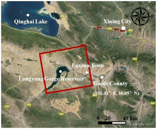
Guide Basin is a tectonic landform unit in the northeast of Qinghai-Tibet Plateau (Miao et al. Citation2012). It is located in the Hainan Tibetan Autonomous Prefecture of Qinghai Province. The high mountains in this area have a layer of permanent snow and the loess covers piedmont belt (Wang Citation2011). Rainfall is concentrated in three months, from June to August. Figure shows the coverage of the ALOS PALSAR image. The left boundary of the coverage reaches Longyang Gorge Reservoir and the right boundary reaches Guide County. The elevation of the study area ranges from 2000 to 4700 m above the sea level. With the elevation high in north and south and low in the middle, this area shows landform characteristics of the multilevel river terraces (Wang Citation2011).
Figure 1. Area coverage of ALOS PALSAR.
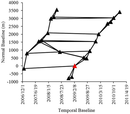
In this study, 21 ascending images acquired from ALOS PALSAR Path 478 constitute the data stack during a time span of four years, from December 2006 to January 2011. With the observation mode of Stripmap, the resolution is approximately 10 m. These PALSAR level 1.0 data consists of both single polarization and dual polarization mode and all the images in dual polarization mode are oversampled to simple polarization mode during the data processing. Furthermore, the Advanced Space-borne Thermal Emission and Reflection Radiometer Global DEM (ASTER GDEM) with the resolution of 30 m is used for removing topographic phase and geocoding. By appropriate combination of all the images, 40 small-baseline differential interferograms are generated from the data stack. The distribution of temporal and perpendicular baselines is shown in Figure .
Figure 2. Temporal and normal baselines of the interferograms.
4. Results
4.1. Mean velocity of deformation
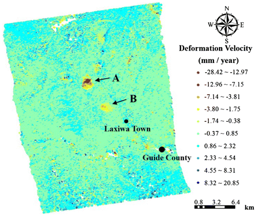
A total of 55,814 point-like targets were extracted with a high density of 172 points per square kilometer to meet the requirement of time-series InSAR analysis in rural area. This can be explained by the fact that sparse vegetation covers the test area and L-band SAR has a good penetrating capability of vegetation canopy with its long wavelength. As a result, it is more preferable to use L-band SAR data from the perspective of achieving high density of point-like targets in loess region.
Figure shows the mean deformation velocities along line of sight (LOS) extracted from the PALSAR data stack. It is significant that two regions with displacement detected by SBAS method are marked as Regions A and B in Figure . Regions A and B are located in the north of the upstream of the Yellow River. The deformation velocity could reach more than 25 mm per year. According to relevant reports, this area is prone to landslides. Both Yehoulang Village and Qunaihai Village, affiliated to Laxiwa Town (Guide County), witnessed landslides during 2006 and 2007.
Figure 3. Deformation velocities in the upstream region of the Yellow River.
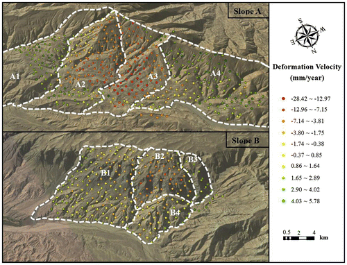
By overlaying this result on Google Earth, it can be found that all the point-like targets in Regions A and B lies on two slopes in the northwest of the Laxiwa Town. In Figure , we use Slope A and Slope B denoting the two potential landslides which are corresponding to Regions A and B (Figure ), respectively. Because of the high density of measuring points, it is not difficult to identify the boundary of the slope. According to the folds on the sliding surfaces, we divided the two slopes into four blocks, that is, blocks A1–A4 for Slope A and blocks B1–B4 for Slope B. For Slope A, the center of the slide surface is located at 101.137°E, 36.162°N. Blocks A2 and A3 show a significant slide trend in the total four blocks, and block A3 demonstrates most of the deformation. At the same time, with more moderate slopes, there is a slight uplift rate of no more than 5.78 mm per year on block A1 and A4. This may be caused by the compressive stress from blocks A2 and A3. For Slope B, the lower edge of the landslide is 2.94 km from the Laxiwa Town and the center of the slide surface is located at 101.166°E, 36.127°N. The fastest deformation occurs in block B2 with a maximum velocity of −17.23 mm per year. Meanwhile, blocks B1, B3, and B4 are relatively stable compared with block B2.
Figure 4. The distribution of deformation velocity on the unstable slope.
4.2. Time-series deformation analysis
Precipitation data of Guide Meteorological Station (Station No.: 52868) are collected from China Meteorological Data Network for seeking an inducing factor of slide activity. Guide Meteorological Station locates at 101.43°E, 35.58°N, 2238.1 m the above sea level. Table gives the value of average monthly precipitation of Guide County calculated from 1981 to 2010.
Table 1. Average monthly precipitation of Guide County calculated from 1981 to 2010.
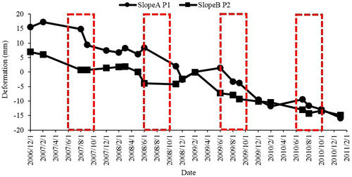
One point-like target is selected on each slope as the representative for quantitative analysis (point P1 for Slope A as opposed to point P2 for Slope B in Figure ). Time-series deformation along LOS of these points is plotted in Figure , from which we can see that the deformation of point P1 fluctuates more widely than that of point P2. That means Slope A experienced a stronger movement than Slope B. This phenomenon also illustrates the reliability of the results in Figure . Noticeably, for both points, there are consistently downward trends from June to August during the InSAR observation period. According to reports in Hainan Tibetan Autonomous Prefecture, heavy rainfall between June and August is one of the main triggering factors of geomorphological disasters in this area. In the meantime, the tendency of deformation coincides well with precipitation data. As a consequence, a preliminary hypothesis would be that there seems to be a close correlation between the potential landslide deformation and seasonal rainfall in this area.
Figure 5. Time-series of deformation at point P1 on Slope A and point P2 on Slope B.
The deformation mechanism of loess landslides induced by heavy rain can be explained in two aspects. First, due to the large permeability and water-absorbent characteristics of loess, the rain will have different degrees of infiltration during the runoff process. Infiltrated water not only increases the water content of the loess, but also increases the weight of the slope as well. From another aspect, once the slope surface has lost integrity, runoff on slope surfaces will quickly recharge the groundwater through channels such as cracks and tunnels, which would cause an increase in the groundwater level coinciding with the slope. These two factors gradually reduce the strength of the weak slip zone by changing static and dynamic water pressure and have a negative impact on the stability of the slope.
5. Conclusions
Compared with the traditional methods of deformation monitoring, there are a multitude of advantages of applying time-series InSAR technique to loess landslide deformation monitoring in the mountainous area of Qinghai Province. In one aspect, SAR images have a large area land coverage which can fulfill the need of deformation surveying for both known and potential landslides. In another aspect, the density of measuring points acquired by the SBAS method is higher than traditional monitoring methods. Furthermore, this method can overcome the serious decorrelation and atmospheric effects in the areas with steep topography and vulnerable geological environments.
In this paper, we verified the effectiveness of the SBAS method in the landslide detection. Combined with the L-band PALSAR stacks, we determined the location, time, and deformation scale of a suspected landslide in Laxiwa Town, Guide County. From the experimental results, we can initially propose that landslide movement on the two unstable loess slopes is triggered by seasonal rainfall. These findings are the basis for our further work in loess landslides detection with abundant data-sets.
Funding
This work was supported by the National Key Basic Research Program of China [grant number 2013CB733205].
Notes on contributors
Yuzhou Liu is a master student of State Key Laboratory of Information Engineering in Surveying, Mapping and Remote Sensing (LIESMARS), Wuhan University. Her research interest is radar remote sensing applications in geological hazard and hydrology.
Mingsheng Liao is Professor of LIESMARS, Wuhan University. He is mainly engaged in time-series InSAR and its applications in topography, geological hazard monitoring, infrastructure security, etc.
Xuguo Shi is a PhD candidate of LIESMARS, Wuhan University. Currently, his research is devoted to radar interferometry and its applications in geo-hazard monitoring.
Lu Zhang is a professor of LIESMARS, Wuhan University. His research focuses on radar interferometry, radargrammetry and geolocation of high-resolution SAR images.
Cory Cunningham is a master student at Hong Kong Polytechnic University. He has a Bachelor of Science in Earth Sciences from St. Francis Xavier University, and a Bachelor of Applied Technology in Geographic Information Systems from Southern Alberta Institute of Technology in Calgary, Canada. His research interests are 3D visualization and 3D data analysis.
Acknowledgments
The authors would like to thank Japan Aerospace Exploration Agency (JAXA) for providing the PALSAR data sets via the ALOS-RA4 project (PI1440).
References
- Berardino, P., G. Fornaro, R. Lanari, and E. Sansosti. 2002. “A New Algorithm for Surface Deformation Monitoring Based on Small Baseline Differential SAR Interferograms.” IEEE Transactions on Geoscience and Remote Sensing 40 (11): 2375–2383.10.1109/TGRS.2002.803792
- Colesanti, C., A. Ferretti, F. Novali, and C. Prati. 2003. “SAR Monitoring of Progressive and Seasonal Ground Deformation Using the Permanent Scatterers Technique.” IEEE Transactions on Geoscience and Remote Sensing 41 (7): 1685–1701.10.1109/TGRS.2003.813278
- Costantini M., and P. A. Rosen. 1999. “A Generalized Phase Unwrapping Approach for Sparse Data.” In Proceeding of the 1999 IEEE International Conference on the Geoscience and Remote Sensing Symposium (IGRASS), 267–269. Hamburg, Germany, June 28–July 2.
- Ferretti, A., C. Prati, and F. Rocca. 2000. “Nonlinear Subsidence Rate Estimation Using Permanent Scatterers in Differential SAR Interferometry.” IEEE Transactions on Geoscience and Remote Sensing 38 (5): 2202–2212.10.1109/36.868878
- Ferretti, A., C. Prati, and F. Rocca. 2001. “Permanent Scatterers in SAR Interferometry.” IEEE Transactions on Geoscience and Remote Sensing 39 (1): 8–20.10.1109/36.898661
- Lanari, R., O. Mora, M. Manunta, J. J. Mallorqui, P. Berardino, and E. Sansosti. 2004. “A Small-baseline Approach for Investigating Deformations on Full-resolution Differential SAR Interferograms.” IEEE Transactions on Geoscience and Remote Sensing 42 (7): 1377–1386.10.1109/TGRS.2004.828196
- Li, X. L., X. H. Guo, and W. H. Li. 2011. “Mechanism of Giant Landslides from Longyangxia Valley to Liujiaxia Valley along Upper Yellow River.” Journal of Engineering Geology 19 (4): 516–529.
- Liao, M. S., and T. Wang. 2014. Techniques and Applications of Time Series InSAR. Beijing: Science Press (in Chinese).
- Miao, Q., F. Qian, Z. Z. Zhao, and X. G. Liu. 2012. “Terraces and Evolution of the Yellow River in the Guide Segment.” Geological Survey and Research 35 (1): 34–38.
- Perissin, D., and T. Wang. 2011. “Time-series InSAR Applications over Urban Areas in China.” IEEE Journal of Selected Topics in Applied Earth Observations and Remote Sensing 4 (1): 92–100.10.1109/JSTARS.2010.2046883
- Wang J. 2011. “Research on Formation Mechanism of Guobu Bank Slope in Front of Laxiwa Hydropower Station at Yellow River.” Master thesis, Chengdu University of Technology.
- Wang N. Q. 2004. “Study on the Growing Laws and Controlling Measures for Loess Landslide.” PhD thesis, Chengdu University of Technology (in Chinese).
- Zhang, M. S., and T. L. Li. 2011. “Triggering Factors and Forming Mechanism of Loess Landslides.” Journal of Engineering Geology 19 (4): 530–540.
- Zhou B. 2010. “Research on Development Characterastic and Mass Mechanism of Superlarge Landslide in the Upper Yellow River.” PhD thesis, Chang’an University (in Chinese).