
Abstract
The 2030 Agenda for Sustainable Development provides a new global policy to guide the way countries collectively manage and transform the social, economic, and environmental dimensions of people and the planet over the next 15 years. Achieving sustainable development presents all countries and the global policy community with a set of significant development challenges that are almost entirely geographic in nature. Many of the issues impacting sustainable development can be analyzed, modeled, and mapped within a geographic context, which in turn can provide the integrative framework necessary for global collaboration, consensus and evidence-based decision-making. However, and despite significant advances in geospatial information technologies, there is a lack of awareness, understanding and uptake, particular at the policy and decision-making level, of the vital and integrative role of geospatial information and related enabling architectures such as National Spatial Data Infrastructures. This paper reasons that the role of geospatial information in contributing to sustainable development has not adequately been described by either the sustainable development policy practice or by the geospatial professional community. This lack of policy and guidance, with commensurate critical gaps and connection points with national geospatial frameworks, is a visible impediment to developing countries and those most affected by the challenges and need to achieve sustainable development. The global geospatial community now has a unique opportunity to integrate and connect geospatial information into the global development agenda in a more holistic and sustainable manner, specifically in contributing their data resources toward measuring and monitoring the 17 Sustainable Development Goals, and their 169 associated targets, through the global indicator framework that anchors the 2030 Agenda for Sustainable Development. This paper introduces and discusses a new strategic framework for linking a global policy to national geospatial capabilities.
1. Introduction
Sustainable development has evolved to mean different things to different people, and in some cases all things to all people, hence it is a term that is as misunderstood as it is understood (Adams Citation2009; Shao, Li, and Tang Citation2011). Despite this ambiguity and being open to much interpretation in its definition and ability to be measured, sustainable development is now being embraced more than ever by global leaders as the world comes to terms with ongoing and emerging development challenges. This was confirmed by the United Nations General Assembly (General Assembly) in September 2015 when it adopted “Transforming our World: The 2030 Agenda for Sustainable Development” (United Nations Citation2015a), a new and universal development agenda for all countries and stakeholders to use as a blueprint for action. The 2030 Agenda for Sustainable Development is the agreed global and united policy to guide the way countries collectively manage and transform the social, economic, and environmental dimensions of people and the planet through to at least 2030, and is anchored by 17 Sustainable Development Goals (SDGs), 169 targets, and a global indicator framework, in order to measure and monitor progress. The 2030 Agenda also captures specific and separate global United Nations system outcomes for small island developing States (United Nations Citation2014), disaster risk reduction (United Nations Citation2015b), financing for development (United Nations Citation2015c), climate change (United Nations Citation2015d), and a new urban agenda (United Nations Citation2016a).
The evolution of sustainable development, as an accepted and valued concept, has progressed in a similar and parallel time frame to geospatial information; over the past five decades or so. It could be argued that they are both still somewhat confusing and difficult to explain to and be understood by society at large, including global leaders, policy and decision-makers. While achieving sustainable development presents the global community with a set of significant social, economic and environmental challenges that are almost entirely geographic in nature, geospatial information is able to provide a set of science and time-based monitoring solutions to these challenges, driven by data and with “geography” as context. As noted by UN-GGIM (Citation2012):
all of the issues impacting sustainable development can be analyzed, mapped, discussed and/or modelled within a geographic context. Whether collecting and analysing satellite images or developing geopolitical policy, geography can provide the integrative framework necessary for global collaboration and consensus decision-making.
Even with much advocacy and many global dialogs, the recognition of the critical importance of geospatial information in sustainable development processes has been limited. Regardless of logical synergies and linkages over a long period of time the reality is that even today, in a highly data-rich and technology-driven global environment, there has been very little connection and fusion between sustainable development and geography, geospatial information and related enabling architectures such as National Spatial Data Infrastructures (NSDIs) at either the political or the technical level (Pesch Citation2014). Now that real baseline data are needed to measure and monitor and make evidence-based decision-making, these gaps and the lack of connection are becoming apparent. Although world leaders have decided how sustainable development will be addressed for the next 15 years in the implementation of the 17 SDGs with commensurate targets and indicators, they have not progressed greatly in their understanding of the need for geospatial information to measure, monitor and manage the SDGs. Why has geospatial information not been visible as an enabling and coherent capability in the global development agenda? Further, how can geospatial information be implemented and integrated into national information systems, at a policy level, in order to contribute more holistically to measuring and monitoring the targets and indicators of the SDGs at a technical level?
This paper examines the origins and evolution of sustainable development, from first concepts to today’s implementation agenda, with a particular focus on geography and geospatial information. It then discusses the geospatial technology evolution and the emergence of Spatial Data Infrastructures (SDIs) before identifying a number of policy and practice signals of change that are of global importance for many countries around the world, particularly the many developing nations. The paper then explores the challenges that must be overcome and argues that for the first time, the global geospatial community, particularly through national geospatial information agencies, has a unique opportunity to integrate geospatial information into the global development agenda in a more holistic and sustainable manner, specifically in measuring and monitoring the targets and indicators of the SDGs. This will be demonstrated by designing a new national geospatial strategic framework for this integration. Finally, the paper presents and describes a conceptual integrative sustainable development ‘data flow’ framework that provides the building blocks for countries to develop and implement within the national geospatial strategic framework.
2. Sustainable development: origins and evolution
Sustainable development concepts first appeared in the literatures in the early 1960s amidst growing concerns of development and environmentalism in Western Europe and North America (Elliot Citation2006; Rostow Citation1960), and quickly advanced to make interconnections between the environment, the economy and social well-being (Carson Citation1962); that the Earth had a finite capacity to sustain human civilization; and that population growth and resource consumption were unsustainable (Ehrlich Citation1968; Goldsmith and Allen Citation1972; Meadows, Meadows, and Randers Citation1972). However, the mainstream theoretical framework and understanding of sustainable development evolved between 1972 and 1992, primarily through a series of international conferences and initiatives led by the United Nations (Adams Citation2009).
The United Nations Conference on the Human Environment, convened in June 1972 in Stockholm, Sweden (also known as the Stockholm Conference), was the first major international conference to discuss environmental sustainability issues at the global scale. The Conference marked a turning point in the development of international environmental politics, emphasizing that defending and improving the environment must become a goal to be pursued by all countries. While sustainable development as a defined term was not referred to explicitly, the essence of its meaning was evident. Principle 2 of the Declaration specifically alluded to managing the environment for the benefit of present and future generations: “The natural resources of the earth, including the air, water, land, flora and fauna and especially representative samples of natural ecosystems, must be safeguarded for the benefit of present and future generations through careful planning or management, as appropriate” (United Nations Citation1972).
To address the growing concern over the “accelerating deterioration of the human environment and natural resources and the consequences of that deterioration for economic and social development” (Drexhage and Murphy Citation2010) the General Assembly established the World Commission on Environment and Development in December 1983 to formulate a global agenda for change and to propose long-term environmental strategies for achieving sustainable development by the year 2000 and beyond. In April 1987 the Commission produced the landmark report “Our Common Future” which advanced the understanding of global interdependence and the relationship between economics and the environment, and also introduced and captured what is now the classic definition of sustainable development: “development which meets the needs of the present without compromising the ability of future generations to meet their own needs” (WCED Citation1987). It contains within the definition two key concepts: the concept of needs, in particular the essential needs of the world’s poor, to which overriding priority should be given; and the idea of limitations imposed by the state of technology and social organization on the environment’s ability to meet present and future needs.
The General Assembly adopted Our Common Future in August 1987, giving sustainable development political salience, and in June 1992 global leaders laid the foundations for its global institutionalization at the “Earth Summit”, the United Nations Conference on Environment and Development in Rio de Janeiro, Brazil. Convened 20 years after the Stockholm Conference, the Earth Summit sought to help governments rethink economic development and find ways to halt the destruction of irreplaceable natural resources and pollution of the planet (Elliot Citation2006). In Rio, more than 178 Governments, 108 represented by heads of State, adopted the Rio Declaration on Environment and Development, and Agenda 21 – a global plan of action for sustainable development. The Rio Declaration contained 27 principles defining the rights and responsibilities of States, while Agenda 21 outlined a comprehensive program for global action in all areas of sustainable development, and included 40 separate chapters setting out actions in regard to the social and economic dimensions of sustainable development, conservation and management of natural resources, the role of major groups, and means of implementation (United Nations Citation1992). Chapter 40 of Agenda 21, pertaining to information for decision-making, recognized the critical importance of authoritative information on sustainable development issues in meeting the challenges of sustainable development. From the outset, the global community recognized that sustainable development had three pillars – environmental, social, and economic – each with its own information needs. The value of geographical information was acknowledged but primarily in the field of environmental information (UN-GGIM Citation2011).
The Millennium Summit was convened in New York in September 2000 by the General Assembly in an attempt to seize a unique and symbolically compelling moment to articulate and affirm a vision to ensure that globalization becomes a positive force for all the world’s people. The Summit concluded with the “Millennium Declaration” which contained a statement of values, principles and objectives for the twenty-first century (United Nations Citation2000). The Declaration committed nations to a new global partnership to reduce extreme poverty and setting out a series of time-bound and quantified targets, with a deadline of 2015, which became known as the Millennium Development Goals or MDGs. However, the MDGs failed to recognize the need for data and geography, and were therefore limited in their ability to track and monitor progress consistently. These limitations will be considered in more detail later in this paper.
Sustainable development concepts to the end of the twentieth century were largely dominated by environmental issues, and were notably weaker in addressing aspects related to social and economic development. This environmental emphasis meant that sustainable development also encapsulated many elements of geography, but ironically there was no real understanding of the need, or even means, to measure and monitor development progress of these geographies, or for harnessing mapping data of a geographic nature in order to do so. This lack of understanding was in stark contrast to the vision of a “Digital Earth” outlined by Vice President Gore of the United States in 1998 (Gore Citation1998). Gore presented compelling arguments for the application of geospatial information to the challenges to sustainable development which leant heavily on the use of location to link environmental information (UN-GGIM Citation2012).
It was not until the World Summit on Sustainable Development, held in Johannesburg, South Africa, in September 2002 that negotiations demonstrated a major shift in the perception of sustainable development – away from just environmental issues more toward social and economic development. This was driven by the needs of the developing countries, and strongly influenced by the MDGs, focusing considerably more attention on development issues, particularly in integrating the MDGs with sustainable development principles and practices. The 2002 Summit reinvigorated at the highest political level the global commitment to achieve sustainable development (Elliot Citation2006) and emphasized the importance of an integrated approach to sustainable development, including the need for quality data and information for decision-making. It was in this context that the need for geographic data was first captured in a global sustainable development dialog. The Report of the Summit specifically called for countries to, inter alia:
promote the development and wider use of earth observation technologies, including satellite remote sensing, global mapping and geographic information systems (GISs), to collect quality data on environmental impacts, land use and land-use changes, including through urgent actions at all levels to … access, explore and use geographic information by utilizing the technologies of satellite remote sensing, satellite global positioning, mapping and GISs. (United Nations Citation2002)
How geographic information and earth observation technologies would actually be applied to sustainable development challenges, or be implemented, was not articulated. There was simply no apex intergovernmental mechanism in existence that could suitably address the production and use of geographic information within national, regional and global policy frameworks – or how they could be applied to sustainable development challenges.
3. Sustainable development: capturing geospatial information
The United Nations Conference on Sustainable Development, or Rio+20, was convened in June 2012 in Rio de Janeiro 20 years on from the 1992 Earth Summit. Rio+20 was pivotal in that it sought to initiate the process for a new development agenda for the future. The focused political outcome document “The Future We Want” (United Nations Citation2012a) contained clear and practical measures for implementing sustainable development, including setting the path to develop a set of SDGs to build upon the MDGs, and to converge with the post-2015 development agenda. The Future We Want captured two critical references to geospatial information within the document’s framework for action and follow-up, and through provision of means of implementation. These were specifically in the area of disaster risk reduction: “We further recognize the importance of comprehensive hazard and risk assessments, and knowledge- and information-sharing, including reliable geospatial information” and in the area of means of implementation – technology: “We recognize the importance of space-technology-based data, in situ monitoring and reliable geospatial information for sustainable development policy-making, programming and project operations” (United Nations Citation2012a).
Although recognizing the importance and need, the outcome document did not articulate how reliable geospatial information, including data and technologies, would be integrated into the many sustainable development policy and practice processes. While this was still to be determined, the post-2015 development debate provided a convergence moment for seizing the power and awareness of geospatial information within the global development community. At Rio+20, world leaders resolved to establish an inclusive and transparent intergovernmental process to develop the SDGs, stating that they should be limited in number, aspirational and easy to communicate. The goals should address, in a balanced way, all three dimensions of sustainable development and be coherent with and integrated into the United Nations development agenda beyond 2015 (United Nations Citation2012a). A 30-member Open Working Group on SDGs of the General Assembly (OWG) was established in January 2013 tasked with preparing a proposal on the SDGs for consideration by the General Assembly during its 68th session in September 2014. Over an 18-month period, and predominantly through 13 intergovernmental sessions, the OWG formulated a set of 17 proposed SDGs, accompanied by 169 action-oriented targets, to be attained by 2030.
These efforts culminated in September 2015 when the General Assembly adopted the 2030 Agenda for Sustainable Development. Containing much more accountability than the MDGs, with considerable emphasis on measuring and monitoring with good policy, science, technology and especially data, the 2030 Agenda specifically demands the need for new data acquisition and integration approaches. The text captures specific references to the need for high quality, timely, reliable, and disaggregated data, including earth observation and geospatial information in the area of follow up and review:
We will support developing countries, particularly African countries, LDCs (least developed countries), SIDS (small island developing States) and LLDCs (land-locked developing countries), in strengthening the capacity of national statistical offices and data systems to ensure access to high quality, timely, reliable and disaggregated data. We will promote transparent and accountable scaling-up of appropriate public-private cooperation to exploit the contribution to be made by a wide range of data, including earth observations and geospatial information, while ensuring national ownership in supporting and tracking progress. (United Nations Citation2015a)
This need has a goal, target and date associated with it, as described in Goal 17 in the area of data, monitoring and accountability:
By 2020, enhance capacity-building support to developing countries, including for least developed countries and small island developing States, to increase significantly the availability of high-quality, timely and reliable data disaggregated by income, gender, age, race, ethnicity, migratory status, disability, geographic location and other characteristics relevant in national contexts. (United Nations Citation2015a)
The adoption of the 2030 Agenda provides the global policy mandate to exploit the contribution to be made by geospatial information to support the SDGs, targets and indicators, but does this provide enough for countries to implement change and achieve the mandate for the geospatial community to be mainstreamed into sustainable development?
4. Geospatial information: origins, issues and challenges
In an almost parallel universe, the first concepts of geospatial information also originated in the early 1960s and, although not realized at the time, were conceived and developed in order to report on environmental sustainable development and the integration of mapping and statistical information. Tomlinson (Citation1962, Citation1963) introduced the use of electronic computers in the storage, compilation and assessment of natural and economic map and statistical data for the evaluation of marginal agricultural lands in Canada to:
initiate studies regarding the application of computers to the storage, compilation and assessment of map data as well as statistical data, and to the production of accurate and specific correlations between the two types of data … so that all factors regarding a specific area may be considered together and that the accurate weighing or comparison of it so that sound judgements can be made. (Tomlinson Citation1962)
This early work created the first computerized GIS through the Canada Land Inventory (Tomlinson Citation1967, 1968) and coined the now globally known term; GIS. The major function of the GIS, at that time using punch-card data entry, was to measure and summarize geographical areas of specific characteristics, demonstrating the various capabilities for spatial data manipulation and analysis to answer many queries of a geographical nature (Goodchild Citation1985).
The 1970s and 1980s saw the technology evolution of geospatial information as computer mapping automated traditional map-making with digital representations and “overlays” of existing paper maps, and mainframe digital computer mapping and cartography software developed, primarily through research institutions and specific large government agencies such as the US Census Bureau (Berry Citation2013; Chrisman Citation2006; Foresman Citation1998). A key milestone on 23 July 1972 was the launch of the first Landsat spacecraft. At the time it was known as the Earth Resources Technology Satellite and was the first satellite launched to study the Earth’s land masses. In 1975, the name was changed to Landsat. Since then, this program has been continuously monitoring changes in the Earth, and its archive represents the longest and continuous space-based record of changes on the Earth’s surface.
The 1980s in particular provided the opportunity for GIS concepts and science to be developed in both theory and practice through the works of leaders like Burrough (Citation1986) where the first principles of raster and vector data structures were described, and digital elevation models (DEMs), spatial interpolation, and raster analysis were introduced. This period also represented a migration of geospatial information technology to more affordable integrated graphics workstations, client–server environments and spatial database management systems, which in turn facilitated the sharing of data across “networks” (NGAC Citation2009) through Transmission Control Protocol and Internet Protocol (TCP/IP). Established in the mid-1980s, TCP/IP provided researchers with the means to assemble the “network of networks” that became the modern Internet (Gilbert Citation1995). The online world then took on a more recognizable form in 1990 when Berners-Lee (Citation1989) invented the World Wide Web, providing a common means of accessing data online in the form of websites and hyperlinks.
Despite some criticism from social and human geography purists (Schuurman Citation2000) the 1990s saw mass adoption of geospatial information and a maturation of spatial analysis and modeling for decision-making (Berry Citation2013). At the same time the Internet provided a means by which to access and utilize standard maps, as GIS vendors encouraged organizations to add and share data-sets to the map sets they were already making available across the Internet through easy-to-use graphical user interfaces (GUIs) and web portals. These same opportunities provided new ways for governments and countries to consider coordinating ready access to geospatial information through the concept of SDIs as a means to overcome important barriers to effective utilization. While the first iterations of SDI development emerged in the mid-1980s (Masser Citation1999), this took a substantial step forward in 1990 when the United States Office of Management and Budget (OMB) established an interagency Federal Geographic Data Committee (FGDC) to coordinate the “development, use, sharing, and dissemination of surveying, mapping, and related spatial data” (Masser Citation2005a). OMB Circular A16 of 1992 defined the SDI “as the technology, policies, standards, human resources and related activities to acquire, process, distribute, use, maintain and preserve spatial data” (OMB Citation1992; revised 2002). Other early innovators and adopters (GSDI Citation2004; Masser Citation1999, 2005a; Masser, Rajabifard, and Williamson Citation2008; Williamson, Rajabifard, and Feeney Citation2003) provided similar definitions that generally reflected NSDIs as being coordinated actions of nations and organizations that promote awareness and implementation of complimentary policies, common standards and effective mechanisms for the development and availability of interoperable digital geographic data and technologies to support decision-making at all scales for multiple purposes. Such NSDI concepts validated the essential role geospatial information would play in modern society and still apply today in an effort to ensure that as much publicly collected geospatial information as possible is made as widely accessible and available in a timely manner and at minimum cost.
The removal of selective availability for the high-quality positioning and timing Global Positioning System (GPS) signal by the US Department of Defense in 2000 (White House Citation2000) disrupted the traditional “static” data norms and paved the way for new “dynamic” global positioning innovations such as in-car navigation systems and a multitude of location-based services via mobile devices. However, perhaps the biggest disruptive paradigm shift was the launch of Google Earth in June 2005, which combined geospatial data processing to create content, then packaged it in an easily consumable format that could be accessed from a web browser on virtually any computing device, while offering a consistent Google visualization experience – and all for free. This enabled geospatial literacy to be introduced to the global community using Google Earth and Google Maps for obtaining answers to questions that they had formerly not known how to ask. More importantly, it changed the way that people understood geography and defined geographic areas, and “mainstreamed” geospatial information and the multitude of consumer location-based applications that are readily available today (NGAC Citation2009).
Technological enablers such as the Internet, cloud computing, Big Data, mobile devices, unmanned aerial systems, and the explosion of location-based services, which bring everyone directly into contact with location information on a daily basis, have ensured that people the world over, are beginning to appreciate the need for geospatial information in their consumption of data (UN-GGIM Citation2013, Citation2015a). As a result, a large proportion of the global community now have an entirely different set of geospatial information uses, needs and expectations than they did even 10 years ago, such has been the evolutionary change. In some respects it also indicates that geospatial information and services are now being driven more and more by users and consumers in response to their contemporary needs as much as responding to technology developments and breakthroughs. Many of the technical hurdles surrounding geospatial information have been aggressively tackled and solved over the past decades, including hardware, software, database and other technological development (Berry Citation2013). Therefore, the potential of geospatial information has rapidly advanced and has now reached a level of maturity that allows this information to make a central contribution to the integration of information for the purposes of global issues such as sustainable development.
4.1. Spatial Data Infrastructures (SDIs) – enabling national information architectures
In order to improve access, sharing and integration of geospatial information and services for evidence-based decision and policy-making, SDIs have emerged as an enabling platform that can also be applied to sustainable development challenges. Feeney, Rajabifard, and Williamson (Citation2001) reasoned that addressing the multiple issues concerning sustainable development creates a growing need to organize data across disciplines and organizations through the development of SDIs to support decision-making. The principle objective for developing SDIs is to achieve better outcomes from spatially related economic, social and environmental decision-making. Further, the design of any SDI requires understanding the nature of the concept, the contributing components, the impact of global drivers and the needs of the user community. Crompvoets et al. (Citation2004) and Masser (Citation2005b) established in the early 2000s that more than half of the world’s countries claimed some form of SDI development, but that the reported levels of implementation and maturity, including the various policy options and institutional structures, were both questionable and not able to be confirmed. Masser (Citation2005c) also noted that the evolution of SDIs is a long-term task and that their “adoption and implementation” often reflect the extent to which (government) organizations reinvent themselves in response to changing political, institutional and technological circumstances. Because of their dynamic and complex nature, SDIs remained a fuzzy concept to many, and depending on their needs and circumstances, practitioners, researchers, and governments adopt different views of them (Williamson, Rajabifard, and Feeney Citation2003).
By 2010 the recognition that countries should develop and implement policies for the efficient and coordinated management of their spatial data and services had become almost universal with SDIs at the national, regional and global levels evolving with increasing resolve and commitment. However, although they are now an increasingly important element of the infrastructure that supports national to regional economic development, environmental management, and social stability there are still inherent policy and institutional limitations that exist in developing such platforms and infrastructures. One of the weaknesses is that many SDIs are still predominately supply, rather than demand, driven and are rarely designed to respond directly to high priority societal policy issues. To more effectively respond to the issue of sustainable development a very clear definition of the problem and the design of an integrated infrastructure to address that problem at the national, regional or global scale is required. In many cases, the SDI community assumes that the infrastructure being created will provide the information to respond to any situation simply by the provision of comprehensive data layers at the appropriate scale. This often leads to a serious “disconnect” between national needs for the management of geospatial information and current SDI approaches. Comprehensive data layers have value in their own right but a more targeted approach is of greater utility to decision-makers (Taylor Citation2010). In addition, many SDIs do not include adequate socioeconomic data, yet these data are critical if SDIs are to act as integrating infrastructures to meet the needs of sustainable development (UN-GGIM Citation2012).
For many national governments, where much of the policy emphasis is placed on providing accurate, timely, and reliable data to support decision-making, there are still significant impediments to providing sustainable information infrastructures for both accessing mapping data and translating it into information for decisions (Berry Citation2013; UN-GGIM Citation2012). The challenge of coordinating and sharing standardized and fit-for-purpose geospatial information has proven elusive in both concept and practice for many national governments, agencies and decision-makers around the world. This is especially so in the least-developed and developing countries where governments continue to face problems of poor data quality, lack of timely data and a lack of interoperability between different sources of data. This may result in governments using, and then relying on, inaccurate or low quality data on which to base their decisions (UN-GGIM Citation2015a).
For example, while geospatial information is increasingly being used in Africa and other developing regions, many countries are frustrated by limited access to data and the absence of tools to allow for analysis and visualization. Innovative and low-cost geospatial approaches are being applied to improve the timeliness, availability, and use of data for monitoring of progress toward sustainable development, but more capacity building will be needed to scale up existing initiatives and to bring innovative applications from other parts of the world to areas such as Africa. The lack of consistent up-to-date base mapping – fundamental geographic data-sets such as geodetic control, elevation, drainage, transport, land cover, geographic names, land tenure, etc. – across Africa remains a challenge, although individual countries are making some progress (GSDR Citation2015).
After several years of intense formulation and political negotiations, there is now a definitive global policy agenda for sustainable development, but there are no evident strategic frameworks or mechanisms for governments to determine how geospatial information can be implemented and integrated into sustainable development processes, especially at local and national levels. This lack of policy and guidance, with commensurate critical gaps and connection points with national geospatial frameworks, is a visible impediment to developing countries and those most affected by the challenges and need to achieve sustainable development. However, for the first time, the global geospatial community, particularly through national geospatial information agencies, has a unique opportunity to integrate and connect geospatial information into the global development agenda in a more holistic and sustainable manner, specifically in contributing data toward measuring and monitoring the SDGs. Many countries will need to develop and/or leverage national policies and practices that formalize the ways in which their geospatial information can be shared, used, and disseminated in line with their national social, economic and environmental development needs. The ability to link these needs into an NSDI remains a practical enabling requirement.
5. Integrating geospatial information into a more strategic approach toward sustainable development: signals of change
The origins and evolution of sustainable development over the past 50 years, including its influence in global development, its now undeniable need and its role at an intergovernmental level is well documented. Conversely, very little is documented or understood regarding the role of geography in sustainable development processes at the intergovernmental level, including how geospatial information can be applied to sustainable development, and how policies can be implemented to bring the two together in a coherent and integrated manner. In some respects this is a reflection of the considerable policy – technical gap that exists within and across countries, but it is also a reflection of the different philosophies of each community. Achieving sustainable development is driven by the need for political negotiation and agreement in order to obtain high level global objectives for the future of our planet. The geospatial information philosophy is more concerned with ensuring reliable and authoritative local to national data and science-based analyses are available on the interactions of people with their places and environment. Therefore, there are obvious differences in understanding and in terminologies, especially in the growing data requirements to support the many social, economic and environmental dimensions of sustainable development, including measuring and monitoring. Fortunately these differences are slowly being brought together through change – motivated partly by awareness and understanding, and partly by pure necessity.
Recognizing the urgent need to take concrete action to strengthen international cooperation in the area of global geospatial information management, the United Nations Economic and Social Council (ECOSOC), established the United Nations Committee of Experts on Global Geospatial Information Management (UN-GGIM) in July 2011. ECOSOC established the Committee of Experts as the apex intergovernmental mechanism for making joint decisions and setting directions with regard to the production and use of geospatial information within national, regional and global policy frameworks (United Nations Citation2011). The report of the Secretary-General which led ECOSOC to establish UN-GGIM explicitly mentioned the role of geospatial information in informing sustainable development policies, including their monitoring and implementation (United Nations Citation2011). At its second annual session in 2012, when considering the contribution of geospatial information to the Rio + 20 processes, UN-GGIM noted that:
Perhaps most importantly, there is a strong belief that geography provides the integrative framework necessary to support the requirements of multiple information communities in a timely and effective manner – providing the right data at the right time to the right place. The same geospatial content, repurposed, can support applications ranging from agricultural management, to emergency planning and response, to scientific collaboration on climate change, to transportation planning. All of these applications have implications for sustainable development and liveability. (UN-GGIM Citation2012)
Considerable progress is being made by this global intergovernmental mechanism at the technical level, but the challenge of policy awareness remains. At its fourth session in August 2014, UN-GGIM observed that:
The level of understanding and rate of uptake of geospatial information, particularly at the policy and decision-making level, remains less than optimal … many do not understand its value and importance within the context of the sustainable development agenda. The production and use of geospatial information within national, regional and global policy frameworks needs to be mainstreamed in order to enhance the capability for governments, international organizations and researchers to analyze, model, monitor and report on sustainable development, disasters, climate change, and other global concerns (UN-GGIM Citation2014).
In early 2014 the United Nations Secretary-General called for a data revolution in support of sustainable development. This call was made in view of the emerging post-2015 development agenda and in anticipation that a sustainable flow of high-quality, timely, authoritative, and accessible data will be needed for ongoing measurement of progress toward the new goals and targets at both the national and the global level. To generate this flow, a data revolution – a transformation of how data are produced and used to drive development – was seen as being critical (IEAG Citation2014a). The Secretary-General established an Independent Expert Advisory Group on a Data Revolution for Sustainable Development (IEAG) to craft a strategic framework and advise the Secretary-General on what the “data revolution for development” would mean in practice. The resulting report “A World That Counts” calls on governments and the United Nations to act to “enable data to play its full role in the realization of sustainable development by closing key gaps in access and use of data”. The IEAG proposed a “global consensus on data” to adopt principles concerning legal, technical, privacy, geospatial and statistical standards to facilitate open information exchange. Such an approach would require interoperability of data and information systems, specifically demographic and geospatial information, including “geographic semantic” management and exchange (IEAG Citation2014b). A key objective is to be able to incorporate new data sources, including data that is compatible with geospatial information systems, and available quickly enough to ensure that the data cycle matches the decision cycle.
The adoption of the 2030 Agenda for Sustainable Development corresponded with the conclusion of the MDGs. The final Millennium Development Goals Report (United Nations Citation2015e) was a key report that summarized 15 years of concerted effort and significant progress in lifting more than one billion people out of extreme poverty. The final MDG Report also provided an opportunity to reflect on some of the important shortfalls encountered and numerous lessons learned as the world tried to achieve the eight aspirational goals. The major lesson – data are an indispensable element of the development agenda. Despite significant and recognized global achievements, the MDGs failed to recognize the need for data and geography, and were limited in their ability to track and monitor progress consistently. In essence, there were no sustainable data to measure and monitor sustainable development. Many of these reflections are highly relevant to the arguments pertaining to geospatial information contained within this paper. These include:
| • | real data improvement occurs when demand and policy support meet; | ||||
| • | despite improvement, critical data for development policy-making are still lacking; | ||||
| • | real-time data are needed to deliver better decisions faster; | ||||
| • | geospatial data can support monitoring in many aspects of development, from health care to natural resource management; | ||||
| • | new technology is changing the way data are collected and disseminated; | ||||
| • | global standards and an integrated statistics system are key elements for effective monitoring; and | ||||
| • | data should be open, easily accessible and effective for development decision-making. | ||||
In the area of “Geospatial data can support monitoring” the report specifically acknowledged the importance of geospatial information:
Knowing where people and things are and their relationship to each other is essential for informed decision-making. Comprehensive location-based information is helping Governments to develop strategic priorities, make decisions, and measure and monitor outcwomes. Once the geospatial data are created, they can be used many times to support a multiplicity of applications. (United Nations Citation2015e)
6. A conceptual sustainable development integrative geospatial strategic framework
With global policy and intergovernmental mechanisms now recognizing and calling for the need to integrate geospatial information into sustainable development processes, the challenge for national geospatial information agencies in many countries is what tangible action can be taken. Firstly, we must consider how the SDGs will be measured and monitored, and how progress is made within and across countries. Then, where are the data and evidence coming from? What are the signals or indicators of progress being made and what is the framework and context? The key question – how can geospatial information be implemented and integrated, at a policy level, in order to contribute more holistically to measuring and monitoring the targets and indicators of the SDGs? Not easy when we consider that very little is understood as to how geospatial information can be applied to sustainable development, and how policies can be implemented to bring the two together in a coherent and integrated manner.
6.1. Integrating geospatial and statistical information
The need to understand the interrelationships across the three pillars of sustainable development – economic, social and environmental – and the impact of the environment on socioeconomic activities, and vice versa, will be critical. Within many national governments, there has been for some time a clear recognition of the need to link statistical information (primarily socioeconomic information) and geospatial information (primarily environmental information) to improve sub-national data, its disaggregation, and the relevance of the evidence on which decisions are made. Put simply, linking people, business, and the economy to a particular place or geographic location can result in a fuller understanding of social and economic issues than is possible through a socioeconomic information lens on its own.
This was recognized by the United Nations Secretary-General in his report to the Statistical Commission in 2012 on global geospatial information management, in which he noted that “one of the key challenges was a better integration of geospatial and statistical information as a basis for sound and evidence-based decision-making” (United Nations Citation2012b). The geographic dimension is increasingly considered as key to virtually all national statistics, as it provides the spatial framework and structure for collecting, processing, storing and aggregating the data. Furthermore, it is generally recognized that “adding location information increases the value of statistics” (United Nations Citation2013a).
In order to best exploit the synergies of both professional domains and information systems, the United Nations Statistical Commission (Statistical Commission) and UN-GGIM established the United Nations Expert Group on the Integration of Statistical and Geospatial Information in 2013 (United Nations Citation2013b) to pursue the implementation of a global statistical-geospatial framework in the 2020 Round of Censuses, with the understanding it would apply to other initiatives including other censuses, such as agriculture censuses, economic censuses, etc., and global initiatives such as the development agenda. While still being finalized, the global statistical geospatial framework is anchored by five agreed guiding principles: (1) Use of fundamental geospatial infrastructure and geocoding; (2) Geocoded unit record data in a data management environment; (3) Common geographies for dissemination of statistics; (4) Interoperable data and metadata standards; and (5) Accessible and usable geospatially enabled statistics (UN-GGIM Citation2016a).
Due to their multi-dimensional nature and breadth, monitoring of and reporting progress on the SDGs will require significant improvements in supporting the national system of statistical information within countries. Existing national data inputs and coordination mechanisms, previously established for monitoring and reporting on the MDGs, will need to be reviewed so as to broaden the scope of the socioeconomic dimensions to include the environmental and location dimensions, thus integrating statistics, geospatial information and earth observations in a more holistic manner (Figure ). This is predicated by the 2030 Agenda requiring new data acquisition and integration approaches to improve the availability, quality, timeliness and disaggregation of data to support implementation at all levels. Data disaggregated by income, gender, age, race, ethnicity, migratory status, and disability are “people” centric; while geographic location refers to “place”. Therefore, the new data needs are for determining and measuring the relationship between “people and place” in the disaggregation process.
Figure 1. Global outputs and reporting progress through the indicators, targets and goals; and key areas of national data inputs toward the production of the global indicator framework.
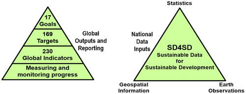
6.2. Measuring and monitoring through the global indicator framework
As indicated in Figure , the 17 SDGs of the 2030 Agenda comprise the integrated and indivisible global goals to be achieved by countries, and applicable for both developed and developing countries, balancing the three dimensions of sustainable development. The 169 aspirational targets provide the detailed and actionable objectives for governments to measure progress through to 2030. Each country will set its own national targets, guided by the global level of ambition, and will also decide how these targets should be incorporated into national planning processes, policies, and strategies. In terms of a robust and annual follow-up and review mechanism for the implementation of the 2030 Agenda, it will be the global indicator framework where the data acquisition, integration and disaggregation will be needed.
In 2015 the Statistical Commission established the Inter-agency Expert Group on Sustainable Development Goal Indicators (IAEG-SDGs) to develop the global indicator framework on behalf of the General Assembly. The indicators will be the quantitative means by which national governments can consistently monitor achievement on, and report progress toward, each of the 169 targets. The real data inputs and subsequent outputs, and hence accountability for results, will be through the global set of indicators, currently comprising 230 indicators (United Nations Citation2016b), and based on national circumstances. However, it is acknowledged that the constraints faced by many developing countries in producing the data necessary to address the indicator requirements will remain an ongoing capacity issue for some time.
While the initial development of the global indicator framework was largely a statistical data approach, based on the similar history of the MDGs, the need for “geographic location” in a new era of data needs has been well recognized. Noting that there are considerably more indicators than targets, the process of developing the indicator framework by the IAEG-SDGs highlighted several key issues regarding the production of indicators with non-statistical data, including being able to address the issues of alternative data sources and methodologies – and particularly using geospatial information and earth observations data. Through this process, the statistical community now understands that geospatial information and earth observations are able to provide new and consistent data sources and methodologies to integrate multiple “location-based” variables to support and inform official statistics and the indicators for the SDGs. These methods are able to fill data gaps and/or improve the temporal and spatial resolutions of data, by bringing together information from various sources, particularly those related to the environment.
UN-GGIM and the Group on Earth Observations (GEO) have worked closely with the statistical community, at a national and global level, to provide inputs into the processes to develop the global indicator framework with the IAEG-SDGs. However, determining the indicators is just the beginning, as they need to then be appropriately interpreted and implemented, guided by robust metadata. The report of the IAEG-SDGs to the 47th session of the Statistical Commission in March 2016 presented a proposal of global indicators for the follow-up and review of the 2030 Agenda and noted that, based on their level of methodological development and overall data availability, the integration of geospatial information and statistical data will also be key for the production of a number of the indicators. Further, the compilation and dissemination of appropriate metadata on the indicators will be critical in order to ensure their consistent implementation at sub-national, national, regional and global levels. Such metadata will need to encompass a full description of the indicator definitions, underlying concepts and methods of data collection, data sources and other relevant information that would facilitate the use and interpretation of the indicators (United Nations Citation2016b).
As a means to address these issues and specific areas relevant to SDG indicator implementation, the IAEG-SDGs established a Working Group on Geospatial Information at its third meeting in April 2016. The Working Group will provide expertise and advice to the IAEG-SDGs and the larger statistical community as to how geospatial information, earth observations and other new data sources can reliably and consistently contribute to the indicators. Its initial work is to review the agreed 230 indicators and metadata through a “geographic location” lens and identify existing geospatial data gaps, methodological and measurements issues (UN-GGIM Citation2016b).
6.3. A national geospatial strategic framework
There is now emerging understanding, in fact a rapidly growing realization, that implementing the SDGs, and measuring and monitoring their progress, will require new and large amounts of data, more rigorous modeling and analysis, and much better data management. It will also take transformative change and collaborative approaches to link different data – demographic, statistical, earth observations, environmental and other societal geospatial data together with the one thing they have in common – to geographic location. Figure proposes that, as an absolute minimum, “sustainable data for sustainable development” will require consistent statistical, geospatial and earth observation data as the core information system inputs into the global indicator framework, and informed by good science, robust methodological approaches, enabling technologies, and sound policy. These national information systems, combined with other sources of new data, including Big Data, will need to contribute the fundamental baseline data inputs, as well as any new required data collections, so that countries will be better able to measure and monitor progress and transformative change within their individual national circumstances.
However, there is presently no evident national policy or framework for governments to determine how geospatial information can be implemented and integrated into their development agendas. This lack of policy and guidance, with commensurate critical gaps and connection points with national geospatial methods and frameworks, is a visible impediment to developing countries and those most affected by the challenges and need to achieve national development. One part of the solution to this problem lies in policy-making that takes into account the social and economic value of geospatial information. Another part lies in the regular and sustainable production and dissemination of geospatial data that reflects the physical world we must measure and monitor. Both of these strategies are vital and complement each other if we are to support, invest in, and advance the knowledge agenda for developing countries, and bridge the digital divide with digital transformation.
Figure illustrates a new National Geospatial Strategic Framework. It is designed as an overarching national policy framework to integrate geospatial and other key information into national sustainable development strategies and to contribute to country implementations of the 2030 Agenda. It firstly comprises a high level national policy context inclusive of a vision and mission, strategic objectives and the primary agencies that would collaborate to provide the national data for development. In almost all countries, whether developed or developing, such data and geospatial information typically reside across several agencies and/or departments within governments, and will likely operate in complete isolation of each other with either very little or no integration capabilities. Therefore, most critical to the success of the Strategic Framework are the national agency data and information systems and their related cross-government coordination, collaboration, data integration and interoperability.
Figure 2. A National Geospatial Strategic Framework to integrate geospatial information into national sustainable development policies and strategies.
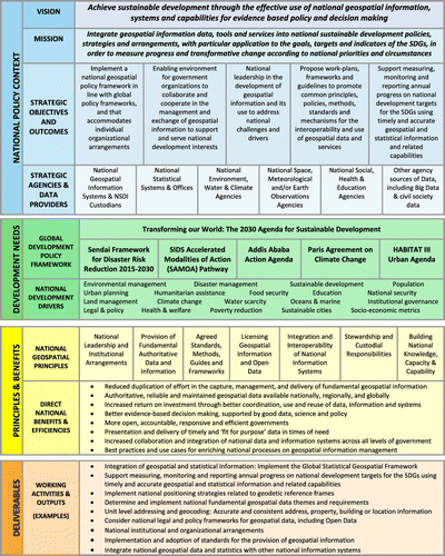
The national policy context is then framed by the global development policy framework and to subsequent national development drivers. In order to anchor the national policy and development needs to the more specific deliverables and working activities, an initial set of geospatial information principles, with commensurate benefits, has been identified to guide the future development of an enabling National Geospatial Strategic Framework. The principles were identified following a review of existing geospatial information management standards and principles. It is anticipated that further work to road test and refine these principles will be undertaken by each country in collaboration with stakeholder agencies. These seven principles set out the central values of sharing and integrating geospatial information and set the foundation for the implementation of geospatial information strategies across government. Intended to support general government priorities, expectations and current national data/information initiatives, adherence to these principles will ensure consistent information management methodologies promulgate across government resulting in more open, accountable, responsive, and efficient governance. The seven principles should be considered with and supported by the Statement of Shared Guiding Principles for Geospatial Information Management, a more high level and generic set of geospatial information ‘organizational’ principles adopted by UN-GGIM in 2015 (UN-GGIM Citation2015b).
The Strategic Framework will assist in addressing the understanding and knowledge gaps in sustainable development through improving policies, frameworks, systems and data for the collection, analysis and dissemination of geospatial information to inform decision-makers and evidence-based policy. This Framework proposes an environment where government organizations can cooperate, and thus improve, the management and exchange of geospatial information to support and serve the national interests, and enables the value of geospatial information to be realized for sustainable development. In order to be effective and avoid duplication of technology and resources, the Framework needs to be cross-cutting across multiple government agencies, and to leverage existing NSDI capabilities and methodologies; but also being able to gather and deliver new data not previously considered.
6.4. A general integrative sustainable development “data flow” framework for national information systems
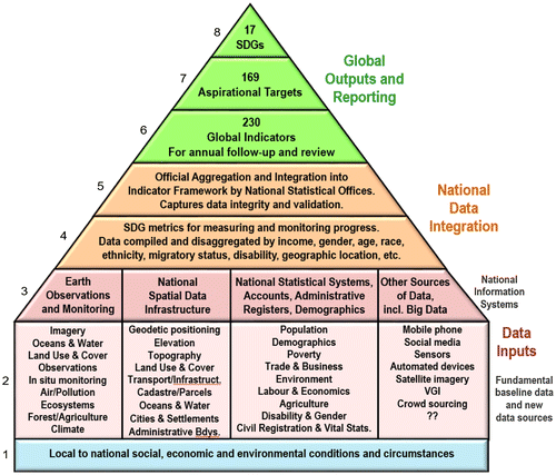
It is important that the goals, targets and indicators of the SDGs are able to be consistently tracked over long periods of time at varying scales, and that comparability across nations can be achieved, including through to globally harmonizing national data. The location element of data, including statistical data, will be a critical consideration. Figure provides a general integrative sustainable development ‘data flow’ framework for national information systems. It comprises a mix of national data that provides the building blocks and processes for any given country to measure and monitor the SDGs from local real-world conditions to global harmonized reporting through robust and reliable data inputs. Working from the base of Figure , the building blocks of the data flow framework are as follows:
| (1) | The local to national real-world social, economic, and environmental sustainable development challenges, conditions and circumstances that exist for countries, and that need to be measured and monitored in order to make progress. For the least-developed countries and small island developing States, limited capabilities and resources, including the means to even understand these conditions and their implications, will initially remain a significant capacity challenge; | ||||
| (2) | Comprises the many and varied mix of fundamental baseline data resources and inputs, including new data collections that will be required. Many of these may need to be “repurposed” or significantly improved in order to adequately measure and contribute to the determined national indicators; | ||||
| (3) | The national information systems that exist within countries will provide the means to ensure access to high quality, timely and reliable data that are structured, organized and managed, ideally in an interoperable and standards-based manner; | ||||
| (4) | The national data are then specifically purposed, compiled and disaggregated by a number of SDG metrics; specifically by income, gender, age, race, ethnicity, migratory status, disability, geographic location, and other characteristics relevant in national contexts. Such data will provide the SDG metrics for measuring and monitoring progress; | ||||
| (5) | The National Statistical Offices will then undertake and finalize the official aggregation and integration into national country indicators, ensuring data integrity and validation; | ||||
| (6) | The National Statistical Offices, and in collaboration with specialized United Nations agencies where appropriate, would then provide the final national indicators to the United Nations Statistics Division to be compiled into the global indicator framework with other countries around the world so that the global outputs can be reported. As decided by the Statistical Commission, estimates used for the compilation of global indicators are to be produced in full consultation with National Statistical Offices; | ||||
| (7) | Initially as the 169 aspirational global targets; and | ||||
| (8) | Finally as the 17 universal SDGs. It is expected that these processes will occur on an annual basis and be formally reported through the annual SDGs Report, as reported in 2016 (United Nations Citation2016c). | ||||
Figure 3. A general national information systems sustainable development ‘data flow’ framework that provides the building blocks and processes for any given country to measure and monitor the SDGs from local real-world conditions through to global harmonized reporting.
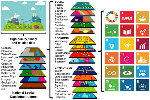
6.5. The national geospatial information system
Figure identifies the National Spatial Data Infrastructure (NSDI) as the national geospatial information system of the sustainable development data flow framework. For many developed countries around the world it is the NSDI, and the provision of reliable fundamental geospatial data, that is able to provide both the enabling platform and connection point to other national information systems and to the SDGs. Although sometimes misinterpreted and under-utilized, the NSDI – or subsequent evolutions thereof – is going to be more important than ever as an integrative framework, but it must be viewed in a more strategic and integrated manner. The modern and agile policy-oriented NSDI, like the considerable and rich data it provides, must no longer be seen as just a simple mechanism for thematic mapping and data delivery. Additionally, the NSDI can no longer operate in isolation to other national information systems. Instead, it needs to be used for data integration, analysis, modeling, aggregation, fusion, communication and for its true capabilities; for organizing and delivering data across disciplines and organizations. There will need to be more integration across the various national information systems and platforms in order to leverage the best and most efficient data and analysis for policy and evidence-based decision-making. The NSDI of the future, fueled by high quality, timely and reliable fundamental geospatial data, can provide the means to organize and deliver core geographies for many national outcomes – including sustainable development.
Within the environment of the NSDI, integrating new data sources and collections, and re-purposing fundamental data into specific thematic topics for addressing the needs of the indicator framework is not technically difficult and has multiple benefits in many areas – assuming that the data already exist in some way, are standards-based, interoperable, and are available. Such concepts were considered by UN-GGIM at its fifth session in August 2015 when the Committee of Experts agreed that there is an urgent need for a set of global fundamental geospatial data themes that can be harmonized in order to enable the measurement, monitoring and management of sustainable development in a consistent way over time to facilitate evidence-based decision-making and policy-making, and to work jointly toward a minimum set of fundamental data themes (United Nations Citation2015f). These efforts are now being advanced and at its sixth session in August 2016, UN-GGIM agreed that in determining the fundamental geospatial data themes, particular consideration should be taken of the special needs of developing countries to be able to measure and monitor the goals of the 2030 Agenda (United Nations Citation2016d). While this work will evolve in the coming period, it is possible to abstractly consider the high level national framework in which the NSDI could provide a nation’s sustainable development geospatial requirements. As depicted in Figure , applying an extended and elaborated set of national fundamental data themes to contribute as data inputs to the SDGs and targets by means of the global indicator framework presents both the considerable challenge and opportunity for the national geospatial information agencies.
Figure 4. Extending fundamental geospatial data themes within the National Spatial Data Infrastructure (NSDI) to accommodate the SDGs and targets by means of the global indicator framework.
Maximizing the value of fundamental geospatial information to capture elements of the 2030 Agenda is going to be critical to the future development path of many national geospatial information agencies in the coming 5–10 years. For many countries, especially developing countries, sustainable development will provide a tangible policy “trigger” to accelerate the development and adoption of legal and technical geospatial standards; openness and exchange of data and metadata; interoperability of data and information systems; and integration of statistical and geospatial information, including its management and exchange. In other words, the 2030 Agenda will be a trigger to accelerate the development and/or expansion of NSDI strategies with commensurate levels of sustainable implementation and maturity. It will also provide a strong consensus on the need to integrate the NSDI within national government’s development plans. An NSDI implementation strategy that is anchored to sustainable development, as an overarching theme, would provide an “information” approach to national policy. It would also bring the analysis and evidence-base to the process, and thereby a consistent monitoring and reporting framework, that would benefit all areas of government, business, the economy and citizen engagement.
7. Discussion and future directions
On 1 January 2016 the world officially began implementation of the 2030 Agenda for Sustainable Development, and the inaugural report “The SDGs Report 2016” (United Nations Citation2016c) was released in July 2016 at the United Nations High Level Political Forum on Sustainable Development by the Secretary-General. This report will be released annually through to 2030 in this method, so time is not standing still and expectations from all countries are high. The lessons from 15 years of measuring and monitoring the MDGs, with only eight goals, taught us that data are an indispensable element of development; that “strengthening data production and the use of better data in policy-making and monitoring are becoming increasingly recognized as fundamental means for development” (United Nations Citation2015e). Therefore data, as the basis for evidence-based decision-making and accountability, will be crucial to the success of the 2030 Agenda. The key word here is “data”. The future success of the global development agendas will be dependent on data, and not whether it is statistical, geospatial, environmental, economic, health, demographic, education, or other data – just data! As we are seeing with consumers and users in the general community and civil society, it is no longer a necessity for governments to know where the data they are using and consuming has come from, or who has generated it. They just want assurances that it is reliable, authoritative, repeatable, the best available and fit-for-purpose in order to make the right decisions and policy. Within the confines of often inflexible government structures, this is not an easy adjustment and requires our professional communities (statistical, geospatial, environmental, etc.) to be less domain specific and more “integrative data and information systems” inclusive, which in turn means that much more coordination and collaboration is required across these organizations and governmental structures. Therefore, the sustainable development data flow framework has 4 main components which capture both policy and data contexts as connected processes. This section will discuss these components and compare them with the current status and evolution of the 2030 Agenda, and will consider future directions and possible gaps that still need to be investigated.
With reference to Figure , at the global level the SDGs, targets and global indicator framework, as “Global Outputs and Reporting”, have been determined by the political process and are now being implemented as policy by governments, and with data requirements expected to be captured within the indicator framework (and therefore colored green). The “National Data Integration” is where the inputs from the National Information Systems are integrated, aggregated and disaggregated against the required SDG metrics. While the policy process, through National Statistical Offices, has been determined the means to compile and disaggregate the data have not. National statistical and geospatial experts are presently considering these data processes under the guidance of the IAEG-SDGs, so they are still work in progress (and therefore colored orange).
The local to national “Data Inputs” comprise 2 critical parts; the first being where the fundamental baseline data and other sources of new data will come from. The data flow framework recognizes that this is presently a melting pot of potentially rich data within and across many government and research agencies in countries, but not yet specifically aligned or re-purposed to the needs of the SDG metrics, as shown in Figure for the case of the NSDI data themes (and therefore colored pink). The second part of the “Data Inputs”, and the most critical to the success of the National Geospatial Strategic Framework, are the National Information Systems and their related cross-government coordination, collaboration and data integration. This is where the future directions and research of the framework will need to be investigated and targeted so that there is an enabling environment where organizations can cooperate and improve on the management and exchange of data within these national information systems. Presently the weakest link (and therefore colored red) the National Information Systems are the means to provide the integrative data information systems for government and sustainable development outcomes; with reliable, authoritative, repeatable, the best available and fit-for-purpose data. Should this institutional, professional and data interoperability be achievable, then how we may acquire, connect, integrate and disseminate data, and by what levels of geographic coverage and disaggregation, or even aggregation, is then dependent on the user needs and specific problems being addressed. Through the United Nations intergovernmental processes there is now a very strong linkage between the statistical, geospatial and earth observation communities, but much more needs to be achieved in order to realize greater national “institutional interoperability.”
Finally, the framework cannot overlook the real-world conditions and circumstances within individual countries (colored in blue) which is where the real measures of progress and success need to be ultimately determined. The biggest challenge here will be in determining a comparative process whereby measuring progress of the SDGs at the global level corresponds with the progress and realities at the national and local level.
8. Conclusions
The objectives of this paper were to provide insights into global sustainable development challenges and processes, how they are closely interrelated with geography, and to demonstrate that the global geospatial information community, through national geospatial information agencies, has a unique opportunity to integrate and connect geospatial information into the global development agenda in a more holistic and sustainable manner. The 2030 Agenda for Sustainable Development provides a new global and transformative policy to guide the way we pursue sustainable development in the coming 15 years. It has determined a set of 17 SDGs and 169 targets, and defined a process for all countries to measure and monitor progress toward implementation through a global indicator framework that is highly dependent on diverse and reliable data to provide the evidence base for decision-making and reporting. For the first time in such global processes, the need for geospatial information, earth observations and other new sources of data, including Big Data, are well articulated.
The national to global policy need and mandate has been demonstrated, but we must also now understand what we are implementing and how we are measuring and monitoring. The objective is to transform the social, economic, and environmental dimensions of people and the planet, particularly in the developing world, to eliminate extreme poverty, to create a future for our children and their children, and to leave no one behind. That is the ambitious policy dialog of the 2030 Agenda. But do we really understand the scale and dimensions of the problems, where they are, whom they impact, what are the causes, and how they can be remedied? To be able to measure and monitor progress for those most in need, the most vulnerable countries, is going to take not only transformational change in our thinking, but also transformational change in how we leverage existing and new sources of data and emerging technologies – a digital transformation. Ironically, the most developed countries are grappling with an abundance of data while in many parts of the world data scarcity prevails. When it comes to sustainable development there is a greater concern. Those countries that are experiencing significant data scarcity are also those that tend to be most vulnerable and at greatest risk of being left behind. A vast “digital divide” remains. The challenge for many of us is how to transfer all of this technology and data richness, availability and connectivity to the technology and data poor? We are on the threshold of immense opportunity with digital transformation and being able to bridge the digital divide that exists among countries, but realizing this opportunity is complex in many dimensions, not the least being the lack of robust national information systems and associated geospatial frameworks. Achieving sustainable development will require digital transformation, but at the moment those countries that need it most do not yet know what it means, as we must first bridge the digital divide.
The expectation of the 2030 Agenda is that by 2020 we are able to increase significantly the availability of high-quality, timely and reliable national data that are disaggregated by a number of characteristics, including geospatial information. Building on the specific requirements of the global indicator framework, this paper has proposed a conceptual sustainable development integrative National Geospatial Strategic Framework that provides the building blocks for countries to link global policy demands to local implementation needs, and to develop and implement within more specific national information and data flow frameworks. However, in order to achieve this outcome, it will require collective global leadership, and it will require appropriate mechanisms and methods to be realized. National geospatial information agencies will need to: collaborate more closely with national statistical and earth observation professional communities; be more unified with similar national to global objectives and aspirations; be delivering consistent and reliable data that is fit-for-purpose; and demonstrate the functionality and value of the geospatial data by integrating it into the wider sustainable development policy process. The introduced approaches and frameworks provide the starting point to such processes, including data and institutional infrastructures such as the NSDIs. They will be improved and refined as more information comes to hand as to how countries will actually be required to report national progress into the global outcomes, and at what levels of detail. Informed by the contributions from this paper, these will be determined by the United Nations statistical and geospatial intergovernmental mechanisms in the coming period.
Notes on contributors
Greg Scott is Inter-Regional Advisor for Global Geospatial Information Management in the United Nations Statistics Division, Department of Economic and Social Affairs. Greg provides high level strategic policy advice and leadership in the coordination and implementation of UN-GGIM initiatives with Member States and related International Organizations involved in national, regional and global geospatial information management. Prior to joining the United Nations in early 2012, Greg spent more than 20 years in Geoscience Australia in a number of key roles, including: delivering Australia’s national topographic mapping, geospatial programs and SDI initiatives; applied research to assess the risks from natural and anthropogenic hazards to Australian communities; and developing the methodological approaches, tools and techniques to model critical infrastructure systems and processes. Greg is a member of the International Advisory Committee of the Centre for Spatial Data Infrastructures and Land Administration, The University of Melbourne.
Abbas Rajabifard is a professor and the head of the Department of Infrastructure Engineering and an associate dean (International), The School of Engineering at the University of Melbourne. He is also the director of the Centre for Spatial Data Infrastructures and Land Administration, The University of Melbourne. Prof. Rajabifard is immediate Past-President of Global Spatial Data Infrastructure (GSDI) Association and is an executive board member of this Association. He is also a member of the Joint Board of Geospatial Information Societies (JBGIS) and was Vice Chair, Spatially Enabled Government Working Group of the UN Global Geospatial Information Management in Asia-Pacific. He has spent his career researching, developing, applying and teaching spatial information management and strategies particularly for SDIs to deliver benefits to both governments and wider society. He has been consulted widely on spatial data policies and management, SDI, and spatial enablement.
References
- Adams, W. M. 2009. Green Development: Environment and Sustainability in a Developing World. 3rd ed. New York: Routledge.
- Berners-Lee, T. 1989. Information Management: A Proposal. European Council for Nuclear Research (CERN). Accessed September 4, 2016. https://www.w3.org/History/1989/proposal.html
- Berry, J. K. 2013. Beyond Mapping III: GIS Evolution and Future Trends. Accessed September 4, 2016. http://www.innovativegis.com/basis/mapanalysis/Topic27/Topic27.pdf
- Burrough, P. A. 1986. Principles of Geographical Information Systems for Land Resources Assessment. Oxford: Clarendon Press.
- Carson, R. 1962. Silent Spring. Boston, MA: Houghton Mifflin.
- Chrisman, N. R. 2006. Charting the Unknown: How Computer Mapping at Harvard became GIS. Redlands: ESRI Press.
- Crompvoets, J., A. Rajabifard, A. Bregt, and I. Williamson. 2004. “Assessing the World Wide Developments of National Spatial Data Clearinghouses.” International Journal of Geographical Information Science 18: 1–25.
- Drexhage, J., and D. Murphy. 2010. “Sustainable Development: From Brundtland to Rio 2012.” United Nations Background Paper prepared for consideration by the High Level Panel on Global Sustainability, September 2010. Accessed December 14, 2015http://www.un.org/wcm/webdav/site/climatechange/shared/gsp/docs/GSP1-6_Background%20on%20Sustainable%20Devt.pdf
- Ehrlich, P. 1968. The Population Bomb. New York: Ballantine Books.
- Elliot, J. A. 2006. An Introduction to Sustainable Development. 3rd ed. New York: Routledge.
- Feeney, M. E., A. Rajabifard, and I. Williamson. 2001. Spatial Data Infrastructure Frameworks to Support Decision Making for Sustainable Development. Accessed September 5, 2016. http://www.csdila.unimelb.edu.au/publication/conferences/SDI_framworks_to_support_decisionmaking.pdf
- Foresman, T. 1998. History of Geographic Information Systems: Perspectives from the Pioneers. London: Taylor & Francis.
- Gilbert, H. 1995. Introduction to TCP/IP. Accessed September 3, 2016. http://www.yale.edu/pclt/COMM/TCPIP.HTM
- Goldsmith, E., and R. Allen. 1972. A Blueprint for Survival. Harmondsworth: Penguin.
- Goodchild, M. F. 1985. “Geographic Information Systems in Undergraduate Geography: A Contemporary Dilemma.” Operational Geographer 8: 34–38. Accessed September 3, 2016. http://www.geog.ucsb.edu/~good/papers/72.pdf
- Gore, A. 1998. “The Digital Earth: Understanding our Planet in the Twenty-first Century.” Photogrammetric Engineering and Remote Sensing 65 (5): 5–28.
- GSDI. 2004. Developing Spatial Data Infrastructures: The SDI Cookbook Version 2.0. Global Spatial Data Infrastructure Association. Accessed September 4, 2016. http://gsdiassociation.org/images/publications/cookbooks/SDI_Cookbook_GSDI_2004_ver2.pdf
- GSDR. 2015. Global Sustainable Development Report: Advance Unedited Version. New York: United Nations. https://sustainabledevelopment.un.org/content/documents/1758GSDR%202015%20Advance%20Unedited%20Version.pdf
- IEAG. 2014a. Terms of Reference. Independent Expert Advisory Group on a Data Revolution for Sustainable Development. Accessed February 7, 2016. http://www.undatarevolution.org/wp-content/uploads/2014/09/IEAG-Data-Revolution_TORs_final.pdf
- IEAG. 2014b. A World That Counts. Independent Expert Advisory Group on a Data Revolution for Sustainable Development. Accessed February 7, 2016. http://www.undatarevolution.org/wp-content/uploads/2014/12/A-World-That-Counts2.pdf
- Masser, I. 1999. “All Shapes and Sizes: The First Generation of National Spatial Data Infrastructures.” International Journal of Geographical Information Science 13: 67–84.10.1080/136588199241463
- Masser, I. 2005a. “The Future of Spatial Data Infrastructures.” Paper presented at the ISPRS Workshop on Service and Application of Spatial Data Infrastructure, XXXVI (4/W6), Hangzhou, China, October 14–16. Accessed September 4, 2016. http://www.isprs.org/proceedings/XXXVI/4-W6/papers/7-16IanMasser-A001.pdf
- Masser, I. 2005b. GIS Worlds: Creating Spatial Data Infrastructures. Redlands: ESRI Press.
- Masser, I. 2005c. “Some Priorities for SDI Related Research.” Paper presented at the FIG Working Week and GSDI-8 Cairo, Egypt, April 16–21. https://www.fig.net/resources/proceedings/fig_proceedings/cairo/papers/ts_36/ts36_02_masser.pdf
- Masser, Ian, Abbas Rajabifard, and Ian Williamson. 2008. “Spatially Enabling Governments Through SDI Implementation.” International Journal of Geographical Information Science 22: 5–20.10.1080/13658810601177751
- Meadows, Donella, Dennis Meadows, and Jorgen Randers. 1972. The Limits to Growth. New York: New American Library.
- NGAC. 2009. “The Changing Geospatial Landscape.” Report of the National Geospatial Advisory Committee. https://www.fgdc.gov/ngac/NGAC%20Report%20-%20The%20Changing%20Geospatial%20Landscape.pdf
- OMB. 1992. “Coordination of Geographic Information and Related Spatial Data Activities.” OMB Circular N0. A-16 Revised 2002. Accessed September 4, 2016. https://www.whitehouse.gov/omb/circulars_a016_rev
- Pesch, U. 2014. “Sustainable Development and Institutional Boundaries.” Journal of Integrative Environmental Sciences 11 (1): 39–54.10.1080/1943815X.2014.889718
- Rostow, W. 1960. The Stages of Economic Growth: A Non-communist Manifesto. Cambridge: Cambridge University Press.
- Schuurman, N. 2000. “Trouble in the Heartland: GIS and Its Critics in the 1990s.” Progress in Human Geography 24 (4): 569–590.10.1191/030913200100189111
- Shao, G., F. Li, and L. Tang. 2011. “Multidisciplinary Perspectives on Sustainable Development.” International Journal of Geo-Spatial Information Science 18: 187–189.
- Taylor, D. R. Fraser. 2010. “Global Geographic Information Management: Some Institutional and Data Sharing Issues in Integrating Geospatial and Statistical Data.” Presentation to the Second Preparatory Meeting of the Proposed United Nations Committee on Global Geography Information Processing, New York, USA, May 10–11. http://ggim.un.org/2nd%20Prep%20Meeting/UN-May-10-Global%20Geographic%20Information%20Management-FINAL-1.pdf
- Tomlinson, R. F. 1962. “Computer Mapping: An Introduction to the Use of Electronic Computers in the Storage, Compilation and Assessment of Natural and Economic Data for the Evaluation of Marginal Lands.” Report presented to the National Land Capability Inventory Seminar held under the direction of the Agricultural Rehabilitation and Development Administration of the Canada Department of Agriculture, Ottawa, Canada, November 29–30. Accessed September 1, 2016. https://gisandscience.files.wordpress.com/2012/08/4-computermapping.pdf
- Tomlinson, R. F. 1963. “Feasibility Report of Computer Mapping System.” Prepared for the Agricultural Rehabilitation and Development Administration of the Canada Department of Agriculture, Ottawa, Canada. Accessed September 1, 2016. https://gisandscience.files.wordpress.com/2012/08/5-feasibility-report.pdf
- Tomlinson, R. F. 1967. “An Introduction to the Geo-information System of the Canada Land Inventory.” Ministry of Forestry and Rural Development, Ottawa, Canada. Accessed September 1, 2016. https://gisandscience.files.wordpress.com/2014/02/3-an-introduction-to-the-geo-information-system-of-the-canada-land-inventory_complete.pdf
- Tomlinson, R. F. 1968. “A Geographic Information System for Regional Planning.” Department of Forestry and Rural Development, Ottawa, Canada. Accessed September 3, 2016. https://gisandscience.files.wordpress.com/2012/08/1-a-gis-for-regional-planning_ed.pdf
- UN-GGIM. 2011. Contribution of the Committee to the United Nations Conference on Sustainable Development Rio+20. New York: United Nations. E/C.20/2011/4.
- UN-GGIM. 2012. Monitoring Sustainable Development: Contribution of Geospatial Information to the Rio+20 Processes. New York: United Nations. Accessed January 17, 2016. http://ggim.un.org/2nd%20Session/GGIM%20paper%20for%20Rio_Background%20paper_18May%202012.pdf
- UN-GGIM. 2013. “Future Trends in Geospatial Information Management: The Five to Ten Year Vision.” United Nations Committee of Experts on Global Geospatial Information Management, United Nations, New York. http://ggim.un.org/docs/Future-trends.pdf
- UN-GGIM. 2014. Activities Related to Sustainable Development and the Post-2015 Development Agenda. New York: United Nations. E/C.20/2014/13/Add.1.
- UN-GGIM. 2015a. “Future Trends in geospatial information management: the five to ten year vision, Second Edition.” United Nations Committee of Experts on Global Geospatial Information Management, United Nations, New York. http://ggim.un.org/docs/UN-GGIM-Future-trends_Second%20edition.pdf
- UN-GGIM. 2015b. “Statement of Shared Guiding Principles for Geospatial Information Management.” United Nations Committee of Experts on Global Geospatial Information Management, United Nations, New York. http://ggim.un.org/docs/statement%20of%20shared%20guiding%20principles%20flyer.pdf
- UN-GGIM. 2016a. Proposal for a Global Statistical Geospatial Framework. United Nations Expert Group on the Integration of Statistical and Geospatial Information. Accessed September 9. http://ggim.un.org/docs/meetings/GGIM6/Background-Paper-Proposal-for-a-global-statistical-geospatial-framework.pdf
- UN-GGIM. 2016b. IAEG-SDGs Working Group on Geospatial Information ToRs. http://ggim.un.org/docs/WG6/ToR%20WG%20on%20Geospatial%20Information%20Final.pdf
- United Nations. 1972. United Nations Conference on the Human Environment. New York: United Nations. A/CONF.48/14/Rev.1.
- United Nations. 1992. United Nations Conference on Environment and Development. New York: United Nations. Accessed April 13, 2015. https://sustainabledevelopment.un.org/content/documents/Agenda21.pdf
- United Nations. 2000. United Nations Millennium Declaration. New York: United Nations. A/RES/55/2.
- United Nations. 2002. Report of World Summit on Sustainable Development. New York: United Nations. A/CONF.199/20.
- United Nations. 2011. Global Geospatial Information Management. New York: United Nations. E/2011/89.
- United Nations. 2012a. The Future We Want. New York: United Nations. A/RES/66/288.
- United Nations. 2012b. Global Geospatial Information Management. New York: United Nations. E/CN.3/2012/31.
- United Nations. 2013a. Report of the Australian Bureau of Statistics on developing a statistical-geospatial framework. New York: United Nations. E/CN.3/2013/2.
- United Nations. 2013b. Committee of Experts on Global Geospatial Information Management: Report on the Third Session. New York: United Nations. E/2013/46.
- United Nations. 2014. SIDS Accelerated Modalities of Action (SAMOA) Pathway. New York: United Nations. A/RES/69/15.
- United Nations. 2015a. Transforming our World: The 2030 Agenda for Sustainable Development. New York: United Nations. A/RES/70/1.
- United Nations. 2015b. Sendai Framework for Disaster Risk Reduction 2015–2030. New York: United Nations. A/RES/69/283.
- United Nations. 2015c. Addis Ababa Action Agenda of the Third International Conference on Financing for Development. New York: United Nations. A/RES/69/313.
- United Nations. 2015d. Framework Convention on Climate Change: Adoption of the Paris Agreement. New York: United Nations. FCCC/CP/2015/L.9/Rev.1.
- United Nations. 2015e. The Millennium Development Goals Report. New York: United Nations. http://www.un.org/millenniumgoals/2015_MDG_Report/pdf/MDG%202015%20rev%20(July%201).pdf
- United Nations. 2015f. Committee of Experts on Global Geospatial Information Management: Report on the Fifth Session. New York: United Nations. E/2015/46-E/C.20/2015/17.
- United Nations. 2016a. HABITAT III: New Urban Agenda. Draft outcome document for adoption in Quito, October 2016. Accessed September 13. https://www.habitat3.org/bitcache/97ced11dcecef85d41f74043195e5472836f6291?vid=588897&disposition=inline&op=view
- United Nations. 2016b. Report of the Inter-agency and Expert Group on Sustainable Development Goal Indicators. New York: United Nations. E/CN.3/2016/2.
- United Nations. 2016c. The Sustainable Development Goals Report 2016. New York: United Nations. http://unstats.un.org/sdgs/report/2016/The%20Sustainable%20Development%20Goals%20Report%202016.pdf
- United Nations. 2016d. Committee of Experts on Global Geospatial Information Management: Report on the Sixth Session. New York: United Nations. E/C.20/2016/15.
- WCED. 1987. Our Common Future: World Commission on Environment and Development. Oxford: Oxford University Press.
- Williamson, I. P., A. Rajabifard, and M. E. Feeney. 2003. Developing Spatial Data Infrastructures. Boca Raton, FL: CRC Press.10.1201/9780203485774
- White House. 2000. “Statement by the President Regarding the United States’ Decision to Stop Degrading Global Positioning System Accuracy.” http://clinton3.nara.gov/WH/EOP/OSTP/html/0053_2.html