
Abstract
This paper examines the current state of three of the key areas of geospatial science in Australia: positioning; earth observation (EO); and spatial infrastructures. The paper discusses the limitations and challenges that will shape the development of these three areas of geospatial science over the next decade and then profiles what each may look like in about 2026. Australia’s national positioning infrastructure plan is guiding the development of a nation-wide, sub decimeter, real-time, outdoor positioning capability based on multi-GNSS and in particular the emerging precise point positioning − real-time kinematic (PPP-RTK) capability. Additional positioning systems including the ground-based Locata system, location-based indoor systems, and beacons, among others are also discussed. The importance of the underpinning role of a next generation dynamic datum is considered. The development of Australia’s first EO strategy is described along with the key national needs of the products of remote sensing. The development of massive on-line multi-decadal geospatial imagery data stores and processing engines for co-registered stacks of continuous base-line satellite imagery are explored. Finally, perspectives on the evolution of a future spatial knowledge infrastructure (SKI) emerging from today’s traditional spatial data infrastructures (SDIs) are provided together with discussion of the growing importance of geospatial analytics for transforming whole supply chains.
1. Introduction
Drawing on a strong tradition of surveying, cartography, photogrammetry, GIS science, and remote sensing built up over many decades, Australia has progressively established a modern geospatial capability that is proving to be increasingly vital for economic, social, and environmental well-being.
This paper provides a picture of the current state and future developments in several specific areas of geospatial sciences in Australia; positioning, earth observation (EO), and spatial infrastructures.
In recent years, Australia has recognized the need to develop a number of strategies to help guide the development of its geoscience infrastructure. The national positioning infrastructure plan (Geoscience Australia Citation2016), led by Geoscience Australia, has been progressively developed and implemented since 2010 as a nationwide multi-GNSS positioning capability at sub decimeter accuracies.
The foundation spatial data framework (ANZLIC Citation2014), developed collaboratively by the Federal Government of Australia and the eight States and Territory Governments (comprising the Australian Capital Territory, New South Wales, Queensland, South Australia, Tasmania, the Northern Territory, Victoria, and Western Australia) under the auspices of ANZLIC (Australia and New Zealand’s peak spatial Council for Governments) comprising 10 fundamental data themes.
In 2015 Australia’s EO community coordination group (AEOCCG Citation2016), representing all people who collect and use EO data in Australia, began a process to develop a strategy to guide the nations’ development of EO capabilities. This strategy was published in 2016.
To better coordinate these various developments, and the broader long-term planning for the geospatial sciences and the industries that rely on them, Australia initiated a process in 2016 to create a spatial industry transformation and growth agenda (2026 Agenda Citation2016) as part of Australia’s overarching national innovation and science agenda. Led by the 2026 spatial agenda working group, a comprehensive process of public consultation identified the barriers to growth, the short, medium and long-term spatial needs of Australia over the next 10 years, and a suite of 30 or so transformative initiatives that are set out in an action plan and accompanying road map. All sectors were consulted; Government, the private sector, and the research and academic sector. The initiatives address the following areas; public infrastructure and analytics, innovation and entrepreneurship, research and development, education, training and capacity building, and out-reach to important areas of the Australian economy, society, and the environment.
A key goal of the 2026 spatial action plan was to see a collaborative and coordinated development of the fundamental components of spatial infrastructure in positioning, spatial data infrastructure (SDI), and spatial data analytics. This paper addresses a number of these key elements.
2. The economics of Australia’s spatial industries
In order to better understand the relative size of the spatial sector and its contribution to the Australian economy, a series of economic assessments have been undertaken over the past decade. The first national assessment of the size of the Australian geospatial sector was undertaken by ACIL Tasman in 2008 who estimated that the sector contributed up to AUD$12.57 billion to GDP or around 1.2% (ACIL Tasman Citation2008). In PWC’s Citation2013 report (PWC Citation2013) ‘Space and Spatial’ was identified as an emerging medium-sized industry sector with a strong growth path, strong competitive advantage and moderate potential for employment growth. This competitive benchmarking analysis of eight nations (excluding the US) identified Australia as being first in GNSS, second in natural disaster management; EO and resources management; satellite communications; weather and meteorology (PWC Citation2013).
In 2013 ACIL Allen (ACIL Allen Consulting Citation2013) estimated that Australia’s GDP was between AUD$2.3 billion and 3.7 billion higher through augmented GNSS and that by 2020 could be between $7.8 billion and $13.7 billion higher. In the same report it was estimated that precise satellite positioning technology would potentially add up to 2.1% to Australia’s gross domestic product by 2030 through productivity gains in mining, construction, and agriculture alone (ACIL Allen Consulting Citation2013).
Over 140 Australian Commonwealth, state, and territory government programmes are dependent on EO from space, and the minimum economic impact of these observations on the Australian economy is approximately AUD$5.3 billion per annum (ACIL Allen Consulting Citation2015). These services are also estimated to have created more than 9000 jobs in 2015, and were projected to generate over 15,000 jobs by 2025. There are numerous examples of the economic and societal benefits generated from EO in Australia, across areas such as weather forecasting, onshore and offshore mining, mitigation and management of natural disasters like bushfires and floods, water resource management, design and assessment of conservation areas, insurance assessment, and land use planning. A series of case studies showcasing the value of EO for different sectors are given in the report ‘The value of EOs from space to Australia: Report to the CRC for Spatial Information’ (ACIL Allen Consulting Citation2015).
The maintenance and growth of Australia’s economic, environmental, and social well-being is dependent on a continuing investment in fundamental geospatial infrastructure and its supporting data, analytics, and skilled capacity.
Let us now turn to the nature and use of these areas of geospatial science.
3. Australia’s national positioning infrastructure
Positioning or location information is now an integral part of modern Australian society supporting applications including surveying and mapping, emergency services, industrial automation of heavy machinery in mining and precision agriculture, transportation which includes air, marine, and land, and a host of other civil, commercial and scientific applications. Position information allows citizens to locate themselves in the world, determine the location of features and infrastructure above and below ground and above the Earth’s surface. Access to accurate position information enables effective decision-making and increases productivity, bringing significant economic and social benefits to the nation. Positioning technologies deliver increased productivity, help improve community safety, and establish a platform for future innovations such as driverless vehicles (Geoscience Australia Citation2016). In Australia, the greatest economic impact from the use of precise satellite positioning technology is in the surveying and construction, agricultural and mining sectors. The transport sectors have also realized important benefits through improved fleet management and safety of navigation.
Although Australia does not have its own navigation satellite system, Australia has been an early adopter of GNSS solutions. While 5−10 m positioning accuracy provided by stand-alone GNSS signals are suitable for many existing applications such as general map and navigation directions, they are not suitable for applications requiring high accuracy high reliability positioning. Therefore, in the last three decades, Australia has invested in GNSS ground infrastructure and operates positioning services to augment the versatility, value, and availability of GNSS technologies. This has resulted in a growing number of economically significant sectors in Australia, such as in precision agriculture, surveying and mining, relying on high accuracy satellite-based services and applications. It has spawned the growth of new industries and opportunities in areas such as location based services (LBS) and intelligent transportation system (ITS) (Rizos et al. Citation2012).
Over the next five years there will be a surge in the launching of new GNSS navigation satellites; the US modernized GPS constellation, Russia’s revitalized GLONASS, the European Union’s Galileo, and China’s BeiDou systems. Furthermore, the deployment of regional navigation satellite systems (RNSS) including the Indian regional navigation satellite system (IRNSS) and Japan’s Quasi-Zenith satellite system (QZSS), as well as satellite-based augmentation systems (SBAS), will bring additional satellites and signals to augment the performance of GNSS. Today, there are more than 90 operational navigation satellites in orbit from these systems, transmitting signals across several carrier frequencies. By the end of this decade, this number will reach well over 120 satellites with even more signals in different frequency bands.
Australia is fortuitously geographically situated in the GNSS ‘hotspot’ (Dempster and Hewitson Citation2007). It has the advantage over North America and Europe of being able to receive signals from these next generation GNSS, RNSS, and SBAS satellites. This creates unique opportunities in Australia to undertake research in multi-GNSS measurement processing strategies and generation of new products and services to secure the benefits multi-GNSS promises (Rizos et al. Citation2012).
A key strategy in Australia for delivering nationwide, uniform access to accurate and reliable positioning information is the development of a national positioning infrastructure (NPI). The NPI is led by Geoscience Australia and recognizes the need for a coordinated strategy and whole-of-nation approach to better utilize the benefits of GNSS, SBAS, out-door ground-based systems and indoor positioning to support government services and industries and deliver economic well-being for Australia.
The NPI’s vision is “instantaneous, reliable and fit-for-purpose access to position and timing information anytime and anywhere across the Australian landscape and its maritime jurisdictions” (Geoscience Australia Citation2016). The NPI is seeking to achieve accuracies of the order of a couple of cm’s, x and y, with no latency for most locations outdoors. In time the NPI is also seeking to marry up the precision outdoor positioning with indoor positioning and location systems to create a seamless positioning and navigation capability for the nation. To achieve its vision, the NPI has been developing a solution to the signal processing and economic impediments to the creation of a sparse, continental-scale, precise positioning multi-GNSS network. This has involved complex and extensive collaboration between universities, private industry, and government agencies for the past decade (Geoscience Australia Citation2016).
Continuously operating reference station (CORS) networks are a common form of ground-based augmentation for GNSS. They permit modeling of errors and subsequently transmission to a user’s receiver so that the error can be corrected to obtain high accuracy accurate positioning information. The current extent of the CORS networks in Australia is shown in Figure (Hausler and Collier Citation2013). These networks offer cm accuracy to approximately 9% of Australia by area (Hausler Citation2014). The NPI seeks to integrate each individual network into a seamless system of systems while provisioning the multi-GNSS solution across the entire nation.
Figure 1. The CORS networks as at 2015 in Australia based on Hausler and Collier (Citation2013) and Hausler (Citation2014).
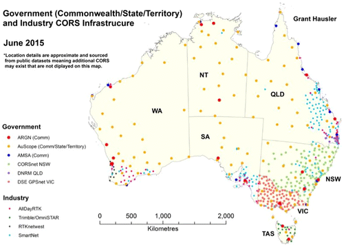
The United Kingdom (Ordnance Survey Citation2017), Ireland (Martin and McGovern Citation2012), Germany (German National Survey Citation2013), Sweden (Lilje, Wiklund, and Hedling Citation2014), Japan (Tsuji et al. Citation2013), and New Zealand (Collett Citation2010) have established nationwide GNSS CORS infrastructure for precise positioning. There are many other countries that have partially developed national coverage with CORS networks for the purpose of precision positioning. These infrastructures were originally established to support precise geodetic and geophysical activities within their countries and territories. They were subsequently upgraded and modernized to provide nationwide high accuracy real-time positioning services (i.e. NRTK (network real-time kinematic)) for various scientific, civil, and commercial applications. These CORS infrastructures typically comprise between 150 and 250 CORS stations (Hausler Citation2014). Geographically, Australia is at least 20 times larger than each of these countries. This implies that up to 20 times the number of CORS stations is needed to deliver high accuracy positioning coverage on a national scale (Hausler Citation2014). This therefore demands a unique approach by Australia to deliver nationwide high accuracy real-time positioning services.
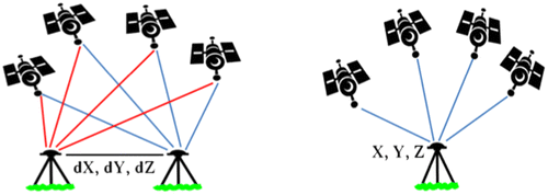
Since the 1990s the dominant GNSS relative positioning technique has been RTK (real-time kinematic) for applications requiring real-time high accuracy positioning solutions. In RTK, the coordinates of an unknown point are determined relative to a ground reference station with known coordinates, by forming differences between observations made by the pair of GNSS receivers. This eliminates, or significantly mitigates systematic errors that are spatially correlated at both receiver locations. The standard mode of RTK utilizes one reference station/receiver, with one or more rover receivers operating in a local area (<10 km). Although this basic RTK mode has evolved into techniques that take advantage of a network of multiple reference stations able to service an extended coverage area (i.e. network-RTK), these techniques still have limitations. One major drawback of the RTK techniques is the need for simultaneous observations at both the reference and rover receivers, and this puts a limit on the baseline length. The baseline length is the separation distance between the reference and rover receivers, so as to provide for adequate cancellation of the spatially correlated biases. In addition, the solutions provided by RTK are relative to a reference station (or stations), which in the first instance, only define a locally consistent reference frame.
PPP (precise point positioning) is an elegant positioning mode, which was introduced in the 1990s (Zumberge, Watkins, and Webb Citation1997). It can provide positioning solutions at centimeter-level accuracy anywhere on the Earth, without the need to have one or more nearby ground reference stations for simultaneous observations. In fact it only requires a small number of reference stations distributed globally, which makes this mode of positioning comparatively cost-effective and operationally very flexible. The distinction between PPP and relative positioning techniques such as RTK (see Figure ) is that, instead of using ground stations as reference points, PPP makes use of precise information of the transmitting satellite positions, clocks, and robust error modeling to derive accurate estimates of user receivers’ position. Hence the PPP technique is especially useful for positioning and navigation in remote land and marine regions where ground-based reference station infrastructure is sparse or unavailable.
Figure 2. The distinction between relative positioning (left, such as RTK) and PPP positioning (right).
3.1. PPP-RTK
Australia is developing a new GNSS precise positioning technique (i.e. PPP-RTK) for the NPI, which will enable real-time positioning services across Australia and its maritime jurisdictions. PPP-RTK is a synthesis of the positive characteristics of PPP and network-RTK (Wabbena, Schmitz, and Bagge Citation2005). PPP is a unique positioning technique that can truly offer global precise positioning solutions without the requirements of local reference networks, while network-RTK could further improve the performance of PPP on a regional scale through provision of accurate atmospheric information aiding rapid fixing of carrier phase ambiguities (Choy, Bisnath, and Rizos Citation2017). Integration of these two techniques will lead to improved position accuracy and timeliness.
3.2. Multi-GNSS
Australian researchers have made a number of helpful advances in the use of GNSS capabilities in recent years. These include the aforementioned development of multi-constellation multi-frequency PPP-RTK algorithm (Odijk et al. Citation2015); (Teunissen and Khodabandeh Citation2014). The successful testing of the Japanese QZSS signals on a robotically controlled autonomous tractor in the Australian State of New South Wales in 2015, represented another. The robotic tractor trial achieved a positioning accuracy of around 5 cm. It also enabled the use of the tractor’s power take-off unit for plowing and other functions, using the communications channel that is also a feature of QZSS (Coppa, Woodgate, and Mohamed-Ghouse Citation2016; Harima, Choy, Kakimoto et al. Citation2015).
3.3. High accuracy mobile positioning
High accuracy positioning is increasingly compelling, and there is an increasing demand for lower priced high accuracy GNSS technology. While high accuracy RTK system are expensive and intended primarily for the surveying and geodetic market, precise positioning using low-cost receivers could have the potential to revolutionize positioning on smartphones, cars, and drones (Pesyna, Heath, and Humphreys Citation2015). In May 2016, Google announced that raw GNSS measurements would be available to application program interface (API) developers in the Android N (“Nougat” = version 7) operating system. The implications of this initiative are significant as it allows the possibility of using GNSS code, carrier phase, and Doppler measurements to derive more accurate positions (Banville and Diggelen Citation2016). In addition, mobile phone GNSS chipset manufacturers like Broadcom and Ublox are currently investigating the applicability of dual frequency L1-E1/L5-E5 GNSS chipset for mass market use. Dual frequency receivers will benefit from improved signal tracking capabilities and ionosphere delay cancellation thereby providing better positioning accuracy. This has already attracted the attention of the automotive sector (Murrian et al. Citation2016). It is worth noting that at present, low-cost GNSS chips and in particular antenna contained in mobile phones cannot outperform geodetic grade receivers. However, it might just be a matter of time before high accuracy GNSS technology makes its way into the mainstream mass market.
3.4. Backup to GNSS positioning
Although GNSS is a versatile positioning technology providing accurate positioning information anywhere on or near the Earth and in all weather conditions, its most severe limitation is that it cannot be used in indoor environments or in urban environments due to the obstruction of GNSS signals.
Locata technology is an Australian innovation developed to augment GNSS with additional terrestrial signals as in the case where there is insufficient sky view for GNSS positioning or to replace GNSS in indoor environment (Montillet et al. Citation2009). Locata permits considerable flexibility in system design due to complete control over both the signal transmitters and the user receivers. One special characteristic of the Locata technology is the time-synchronous capability, allowing centimeter-level positioning accuracy using carrier phase measurements.
Locata partnered with Leica Geosystems to develop LocataLite transmitters and LocataLite-enabled GNSS receivers to augment GNSS systems for mining applications (Rizos, Gambale, and Lilly Citation2013) as the visibility of GNSS satellites is greatly reduced as the open-cut mines get deeper. The solutions provide uninterrupted operation, thereby solving the common problem of blocked satellites and resultant downtime which affects productivity in the mining industry. Also tested at US White Sands missile range, the company’s V-Ray antenna delivered location information at 6 cm horizontal, and 15 cm vertical accuracy to aircraft flying at 25,000 feet altitude, at a speed of 550 mph (Locata Citation2013).
Satelles Inc. has worked in conjunction with the Boeing Company and Iridium Communications Inc. since 2013 to develop satellite time and location (STL) signals for transmission by low-earth orbiting Iridium satellites. As the Iridium satellites are 25 times closer to earth than GNSS, STL signals are up to 1,000 times stronger. The signal beams are high-powered, which means it can penetrate many difficult environments including indoor, and helps to prevent interference like jamming and spoofing. In addition, STL’s cryptographic security also ensures accurate, secure, and accessibility in applications where position and time assurance is critical. This technology can serve as a backup to the GNSS infrastructure supporting safety of life and mission critical applications (Gutt Citation2016; Satelles Citation2016).
3.5. LBS and indoor positioning
Non-GNSS systems provide alternatives where GNSS coverage is limited or unavailable. The most obvious application of non-GNSS systems is indoor positioning and LBS. LBS resulted from the convergence of three technologies in one device; positioning technologies, mobile Internet access, and mobile user interfaces. Positioning for LBS using mobile phones is often provided using non-GNSS technologies like cell-identification (Cell-ID), trilateration, or triangulation of signals between cell towers or a combination of both GNSS and non-GNSS technologies known as assisted GPS (A-GPS) (Ahson and Ilyas Citation2010). Non-GNSS technologies such as Wi-Fi, Bluetooth, digital television, and radio that are transmitted for purposes other than positioning, but can also be used for positioning, are termed “Signals of Opportunity.” Wi-Fi positioning enables 10−20 m accuracy provided that Wi-Fi access points exist and the coverage range is typically 50−100 m (Mautz Citation2012).
Bluetooth low energy (BLE) beacons are rapidly being rolled out, in particular for indoor location and advertising in shopping areas and for health care application. Beacons send signals to mobile devices via Bluetooth. As beacons are placed at several positions in the building and their positions are known, it is possible to determine the coordinates of the mobile devices using trilateration or multi-lateration technique.
3.6. A next generation datum for Australia
Determination of location in a well-defined reference frame and datum is a capability that is rapidly gaining importance with globalization of services and applications. Many applications particularly those in transportation such as aviation, maritime, and road, operate within globalized frameworks that require a globally compatible datum and conform to international standards. In fact, one of the key strategies to meeting Australia’s future positioning needs is the modernization of the national geodetic datum to be known as the geocentric datum of Australia (GDA). The continental plate of Australia is drifting north-east at a rate of approximately 7 cm/yr. The current Australian datum, GDA94, is a static geocentric datum, implemented in 1994. Since then x and y positioning errors of around 1.5−1.8 m have accumulated and in a precision world, where cm accuracy is increasingly demanded by users, these errors are increasingly unacceptable. The sort of problems this generates for users is illustrated in Figure (ICSM Citation2016). So Australia has developed a plan to move to a dynamic datum.
Figure 3. The effect of Australia’s continental drift of around 7 cm north−east each year when comparing positions from the static 1994 Australian datum GDA94 in 2015 and then in 2020.
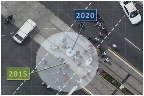
The modernization of Australia’s national datum will be implemented in a two-stage process. Stage 1 in January 2017 will introduce a new GDA datum with coordinates projected to a reference date of 1 January 2020 with the datum to be known as GDA2020. This will introduce an approximate shift of 1.8 m in a plate-fixed datum. The new datum will be more closely aligned to the international terrestrial reference frame (ITRF) such that residual differences in coordinates will be negligible. Stage 2 will be implemented after 2020, which allows transitioning to a dynamic datum, allowing positions and their movement over time to be modeled (ICSM Citation2016).
To further improve the quality of the dynamic datum and to underpin the NPI in 3D Australia is developing a capability to include a rigorous uncertainty budget associated with the offset between the ellipsoid and the Australian Height Datum. Ellipsoids are derived from geoids which in turn are derived from the surface of the earth’s gravity field, approximating mean sea level. Australia has its own geoid, known as AUSGeoid, which provides the offset between the ellipsoid, realized by GNSS signals, and the Australian height datum. In this way the national vertical datum is derived, a key component of a 3D and precisely positioned modern spatial infrastructure. A problem for Australia is that the move to compliance with the International Terrestrial Reference Frame with the new dynamic datum will create about a 90 mm change in heights thereby rendering the current configuration of AUSGeoid incompatible with GDA2020. Research is underway to compute errors in the new gravimetric component and combine them with the errors from the geometric component. The combined error budgets will enable GNSS users of the NPI to receive an uncertainty estimate that will vary as a function of location helping them to determine how precise and accurate their height estimates are at every location.
Taken together these developments associated with the NPI provide a number of fundamental improvements to the users of coordinate-based 3D positioning information across the Australian continent including the uniform and reliable provisioning of accuracies supported by estimates of precision in 3D, and precision positioning in real time.
4. EO current capabilities in Australia and future considerations
EO is a set of activities that use remote sensing to gather observations and produce measurements and spatial data to monitor and examine our planet, its environments, human activities, and infrastructure. These data-sets form the basis of extensive geospatial-: data; products; information; analytics and services that underpin all levels of government activity in Australia from local to national scales, and industry over a similar range of scales. EO data are collected at a range of spatial and temporal scales from centimeters to kilometers, throughout all our environments − built, natural, and managed. Some EO data have been collected regularly for decades through ongoing satellite programmes (such as Landsat) and airborne surveys, while other data may be collected at specific times and places to respond to particular needs such as natural disasters or emergency situations.
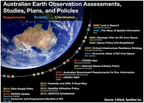
Australia has an active and diverse EO community distributed across research and education, all levels of government, private industry, and NGOs. A summary of the chronology of some of the more important reports and policy developments in Australia’s EO evolution is given in Figure . Although Australia does not operate any EO satellites, government, industry, and research groups are active across the entire EO supply chain beginning with the initial stages of data collection and storage, progressing to processing, analysis, development and delivery of services and distribution, and also in the research development of new EO sensors and processing algorithms. The EO sector transforms EO data to value-added spatial information and services for government and industry and supports the end use of EO-based spatial information products and services by public and private sectors in everyday activities.
Figure 4. An overview of the Australian recent timeline with respect to EO studies, plans, and policies in Australia.
Australian government agencies at all levels have systematically collected EO data over Australia since the 1940s, as evidenced by the extensive state-based aerial photo and image archives, the majority of which are now in digital on-demand form and able to be integrated with other spatial data (e.g. https://qimagery.information.qld.gov.au/). Since the late 1970s, the nation has moved to routine acquisition of satellite data, and since 2010 this has seen dramatic advances in:
| (1) | The ability to collect EO data across multiple satellite, airborne, and other platforms such as drones or unmanned aircraft systems (UAS) now referenced as RPAS (remotely piloted aircraft systems) and the types of sensors these use; from digital photography to multi and hyper-spectral sensors, airborne LIDAR, and satellite radar and radiometry; | ||||
| (2) | Improved access to these data from sites of a few square meters to continental and global scales on a regular basis; and | ||||
| (3) | Improved ability to store, process, analyze, visualize, and distribute very large and long-term EO data-sets online, and to deliver derived spatial information and services to a wide range of users through mobile devices and websites. | ||||
While Australia operates no EO satellites of its own, it accesses a wide range of satellite imagery, at moderate to low spatial resolution (20 m−1 km pixels) through long-standing partnerships and arrangements with other countries. As part of these arrangements, Australia provides important ground station capability, highly skilled personnel, data access and distribution infrastructure, along with essential long-term stable calibration and validation data-sets and sites to our international partners, and development of new algorithms and processing workflows. In combination, these activities add value to the available data for both our partners and ourselves. Access to higher spatial resolution data is through a range of private industry satellite, airborne, and RPAS providers. There is no comprehensive survey on the extent and value of EO data collected across all of these sectors, with only the satellite EO sector being valued on a regular basis. The number and types of all these data sources are increasing continually.
While the existing impacts and level of dependence on EO in Australia are very significant in terms of diversity of activities and economic value, there is significant unrealised potential for the EO sector in Australia (AEOCCG Citation2016); (Symbios Citation2015). Unless change occurs across the sector, this unrealised potential will grow, in effect translating to a net loss in essential capability for satellite, airborne and RPAS data collection, processing and delivery. This will also detrimentally impact Australia’s ability to develop, deliver, and maintain essential spatial information infrastructure and services. Some well-documented challenges will become significant barriers to growth if not addressed, including:
| • | Assuring coordination and a consistent vision within the EO community across research and education, government, and private industry, to ensure effective cooperation, collaboration, and use of resources within the sector, as well as improving advocacy by the sector at national and international levels. This vision needs to be backed by a clear strategy. When realized this will bring together a far more effective critical mass of expertise significantly increasing the value returned from Australia’s investment in EO; | ||||
| • | Developing a clear, coordinated strategy to invest in and protect our international partnerships to ensure continued access to satellite data and international expertise, especially given our high dependency on foreign-owned satellite data; | ||||
| • | Providing clear pathways to develop, support and sustain the EO capacity required for Australia through skilled people, a growing knowledge base, and advanced data collection, storage, and analysis infrastructure; | ||||
| • | Effectively managing and enabling access to the very large and rapidly growing collections of EO data including historical archives and required new data streams, and taking advantage of new information systems technologies for storage, processing analysis, visualizing and transfer, to overcome historical problems and future challenges with discoverability and access to the data, products and services; and | ||||
| • | Establishing connections between EO producers and users to enable the development of EO products and services suited to current and future user needs, and supporting the commercial development of EO applications to deliver productivity gains across the economy, among other societal benefits. | ||||
An excellent illustration of the benefits that can be derived by harnessing the three decades of archived satellite imagery, associated algorithm development and continental scale field calibration and validation programs are the moderate spatial resolution multi-spectral satellite image archives and analysis tools using Landsat and Copernicus program data that have been developed by several agencies. These include similar very large-scale data storage and processing capabilities for whole of Landsat archive analysis built by several state government and Commonwealth agencies, and the research community through the Terrestrial Ecosystem Research Network collaborative research infrastructure program. Each of these systems delivers an on-line archive of analysis ready geospatial data in the form of geocorrected and atmospherically corrected satellite image archives that are matched to extensive continental scale field data-sets and are used to deliver time series data-sets of essential environmental monitoring variables, such as vegetation cover. They provide a central component of Australia’s essential spatial information infrastructure. Development and operational use of these systems for legislated environmental monitoring and management pre-dated similar global initiatives such as the Google earth engine. More recently, the Australian government and research systems are being accessed by private industry to provide on-demand geospatial analytic services for property level assessment of grazing land and crop conditions. Specific application details from these massive on-line multi-decadal geospatial data stores and processing engines include:
| • | Continental scale long-term data bases of essential environmental variables, such as surface water cover, vegetation dynamics, and inter-tidal areas (Lewis et al. Citation2016); (Lymburner et al. Citation2016) through the Australian geoscience data cube (AGDC); (Dhanjal et al. Citation2016). | ||||
| • | New continental scale environmental monitoring variables for vegetation structural properties (Gill et al. Citation2017); and | ||||
| • | Custom applications for environmental monitoring within set property boundaries and for NGO’s checking government estimates of environmental condition (www.vegcover.com.au) (Johansen, Phinn, and Taylor Citation2015). | ||||
The approaches developed by Australian agencies for large on-line data stores and HPC on-demand compute capability to process them has developed in parallel with other activities globally which has seen a shift by major EO agencies and public/private data and compute providers, such as Google and Amazon, now providing long-term satellite image archive data as part of their public data services. Substantive publicly accessible code for processing these types of data can now be applied to the on-line archives using cloud processing. The majority of commercial image processing packages, such as ENVI and Hexagon, are now moving to similar processing models.
The AGDC and other data stores and processing engines will also operate as key piece of the nation’s spatial infrastructure through its ability to scale to other data sources such as SAR and meteorological data.
5. SDI in Australia
Australia has made considerable advancements in collecting, managing, accessing, analyzing, and visualizing spatial data, and many applications exist with tools to query data so users can gain new insights and knowledge, and subsequently make and act on decisions.
Nevertheless, there are a number of complex challenges to be overcome if Australia is to achieve an infrastructure where people can immerse themselves in an environment of knowledge discovery; where spatial data and analytics underpin people’s ability to make the right decisions at the right time. The future Australian knowledge economy will require spatial information, analytics and technologies as an essential ingredient in the broader network of information resources, and unlike most resources, spatial information grows with application – showing what is happening (where, how and why) and providing insights and impact of the past, the present, and the (likely) future.
Good decision-making requires knowledge, knowledge requires reliable information and reliable information requires data, often from multiple sources (Murray Citation2003). Given this dependency on information reliability, getting data organized and making it accessible has been at the forefront of Australian spatial infrastructure activities. The main focus has been on providing geospatial data in the form of distributed spatial web services, data retrieval through catalogs, and visualisation in the form of web map services (WMS) (W3C Citation2016).
Australian, Federal, State, and Territory Governments have progressively developed globes to disseminate and provide visualization services for their geographic information.
Most Australian governments have adopted, or are in the process of developing, open data policies to make as much data as possible available to the community. The use of globes has meant that thousands of data-sets based on geospatial data are now available to the public. For example the National Map, based on a fully open architecture with the source software available on Github employs a number of source libraries including TerriaJS, Cesium, and Leaflet. It now provisions over 5000 data-sets. These globes have allowed a far greater range of organisations to utilize point of truth data and these organisations can combine their own information for specific business purposes. The number of downloads per annum is in the billions. For example the Queensland Globe received an average of 175 million data requests per month (quarter 1 of 2015), including from outside Australia (Coppa, Woodgate, and Mohamed-Ghouse Citation2016).
Australia is facing increasing demands for more versatile representations through accessible online systems. While visualization capabilities are dynamic and multi-dimensional, and large data files can be viewed and refreshed rapidly, these tools are generally limited to high-end systems and not accessible to many users. Currently, Federal, State, and Territory Globes display predominantly static data, with the exception of real-time sensor feeds, such as fire hotspots and lightning strikes through the Sentinel and Fire Watch wild-fire monitoring systems. Visualizations are generally two-dimensional representations and the underpinning geographic data is based on 2-D or 2.5-D models.
Moving to 3 and 4-dimensional representations poses some significant challenges. Firstly, how to migrate data from the traditional 2-D environment; how to manage changes over time and view this history in 4-D; how to portray data dynamically for mobile technologies requiring datum translations; and how to maintain visual (and mathematical) alignment of data across data themes, particularly when cadastral boundary data is progressively spatially upgraded.
Australian Federal, State, and Territories Governments contribute the data they collect to produce seamless nationwide products. One of the earlier national products was created by PSMA Australia in 1996 with the aggregation of jurisdiction data for the Australian Bureau of Statistics (PSMA Citation2009). Building on this success, ANZLIC established the national foundation spatial data framework (FSDF) in 2014 to meet the demands of users for an increased number of commonly used nationwide geographic reference data (ANZLIC Citation2014). This Framework comprises 10 data themes; geocoded addressing, administrative boundaries, positioning, place names, land parcels and property, imagery, transport, water, elevation and depth, and land cover. Together these represent some 1000 data-sets that are the basis for the majority of location-based applications across Australia.
The FSDF was not established overnight and its development required considerable stakeholder consultation to arrive at a point where data themes are in line with mainstream users. Sustainability of the FSDF is reliant on the cooperation of Federal, State, and Territory agencies that have responsibility, as well as a financial obligation, for the collection, management, and upkeep of specific data-sets. These data-sets can be viewed via the national map portal (Globe).
With many agencies involved in the collection of spatial information, ANZLIC adopted data standards, polices and guidelines early to better manage data federation – the first iteration of these were completed in 1990’s and subsequent versions have been enhanced to aligned with ISO Standards developed at a later date. These standards, policies, and guidelines have facilitated supply chain cooperation for the production of nationwide products. Nonetheless, a revamped data policy governance framework is required to incentivise and drive change to make spatial data relevant to users in addition to spatial data experts.
Spatial data supply chains are an ongoing challenge. The breadth of information required to answer a query is often fragmented across a number of agencies that may or may not participate in the same spatial data supply chain (Dressers Citation2013). In addition, current supply chains are extremely manual and need to be simplified and automated. It is currently difficult to warrant data as its provenance and lineage cannot be automatically collected as it traverses the supplier/user network. This makes it difficult to manage intellectual property rights associated with value-added data-sets and where data-sets are an aggregation of data from multiple suppliers.
In addition, each jurisdiction has different workforce priorities, data release policies, business rules and quality compliance standards, and over time data models have become a hybrid of the standard as business needs have progressively diverged. This is impeding the unification of systems.
There is also a deep-rooted problem associated with duplicate data with some agencies collecting the same or similar information to meet their own internal purposes. The digital cadastre, for instance, is maintained by telecommunication, utilities, and local governments in isolation of the land agencies, and in the State of New South Wales, a 2016 review identified over 100 different versions of the cadastre. It is hard for users to abandon their systems and combine their efforts within a unified system because of their entrenched business value and reliance on customized technical approaches. Cultural barriers also exist. Point-of-truth is not always enforced and needs to be further addressed through policy principles. The development of conflation mechanisms to resolve the historical replication problems, and collaborative environments where partners can co-maintain a single data-set under shared resourcing regimes may help overcome the reducing duplication. The latter, to some extent, will also assist resolving the current scarcity of spatial skillsets in the workforce, and there will be considerable cost savings in working together rather than maintaining separate approaches.
Australian governments have built several decision-support and knowledge-based systems that have utilized spatial analytics as the software core to answer end user queries. Western Australia’s interest enquiry (ICSM Citation2014) system, for example, enables the consumer to purchase a property report that details interests incumbent on land, and aurora provides fire agencies with the tools to map, monitor, and simulate fire spreads across Australia. These first class systems are based on knowing and understanding consumer needs and query interfaces are predefined and hardcoded.
In reality, however, data producers rarely know the needs of end users – the nature of decision-making being a vast array of knowledge domains. The challenge will be to move beyond static query systems to a dynamic model that has the capacity to compute unpredictable consumer needs and uses. This calls for more open query interfaces underpinned by sophisticated natural query language processing, on-the-fly spatial analytics and an array of visualization methods. The future system needs to be able to accommodate non-spatial experts. This is forward looking and equates to the ‘intelligent assistant’ available on mobile phones today.
6. Spatial data and analytics
Building on the success of past innovations and addressing current problems requires new thinking. In the past, technological advancements have been hindered because knowledge discovery and data supply have traditionally been researched as mutually exclusive problems. Today, Australia is tackling this duality more holistically.
Australia’s knowledge-driven future is dependent on data and analytics. In the past, emphasis has been on pushing spatial data out to users based on needs ascertained through consumer surveys. In the future, the ability to derive knowledge from information on-the-fly is expected to be the new norm as mobile technologies, global e-commerce and the Internet of Things (IoT) reshape consumer behavior and expectations. Today’s consumers want a more personalized experience, self-actualization in the pursuit of knowledge and, above all, immediacy.
With this in mind, Australia is moving toward a next generation SKI that focuses on the user’s ability to acquire reliable real-time knowledge to meet their circumstance.
The term SKI is not new and has been used interchangeably with SDI since the mid 2000s (Markus Citation2005; BOSSI Citation2006) to describe a framework for making data discoverable. In contrast, the next generation SKI for Australia puts more emphasis on knowledge. Instead of downloading, reformatting, and manipulating data to answer a query, the end user will simply pose a question through an open interface to retrieve a response that matches their context.
These questions are likely to be multifaceted and require complex spatial analysis. For example: Where do we locate the new hospital? Which areas should be declared fire risk zones? Where should I evacuate from flood waters? What are the main concerns of my constituents? Should we insure this property? and so on. The challenge will be to design ontologies (Stock et al. Citation2012) and orchestrate the analytics.
The ability to extract knowledge is an essential component of the broader knowledge economy and the SKI is envisaged as a significant contributor to knowledge discovery. In this new paradigm, government Open Data will be able to be interrelated with other data on the Web, such as community data, social media, and online encyclopedias, in a way that provides a rich source of diverse knowledge from which new insights can be realized through orchestrated spatial analytics (Figure ).
Figure 5. Conceptual diagram of the next generation SKI.

This concept of commoditizing knowledge creates substantial challenges. New query capabilities are likely to stem from semantic web technologies, where the linked open data paradigm is generating a network of interconnected data and information. With linked open data relationships between geographic features can be established across data-sets creating a powerful mechanism to draw meaning from data. In addition, the semantic web resource description framework is providing a universal standard for the interchange of data on the web. This is facilitating data integration even when data schema may differ (W3C Citation2016).
While semantic and linked open data technologies have been available for some time, the spatial industry has been hesitant to assume its use, and the publication of semantic web formats is not yet common practice. Nonetheless, Australian research is examining a combination of problem-directed spatial analytics, natural language query processing, semantic and spatial filtering, automatic capture and extraction of provenance, domain ontologies and rules (Varadharajulu et al. Citation2016), and orchestration of geospatial processes (Bing et al. Citation2016) etc., to demonstrate the power of the semantic web in enabling users to draw knowledge from data.
The transitionary technologies and methods, to move from an SDI to a next generation SKI, are illustrated in Figure and accord with the shift from Web 2.0 functionality to the enhanced Semantic Web 3.0 capabilities.
Figure 6. The transitioning from an SDI to an SKI.
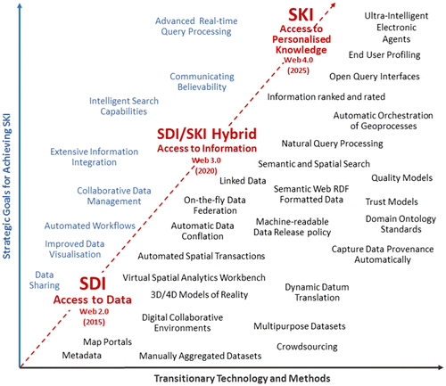
This shift in capability is more than just a single step innovation. Benefits from incremental improvements have already been wrung out of current SDIs and revolutionary methods are required to take capabilities to the next level of knowledge discovery, as well as the automation of spatial data supply chains.
Australia has developed a research strategy (CRCSI Citation2013) that will address the current and future needs of spatial data users and work toward overcoming some of the limitations inherent in current SDIs. Its key elements are addressing:
| (1) | A multi-faceted research approach that seeks to improve the quality and overall management of spatial information. Crowdsourcing and trust models will become a more viable data sourcing solution for maintainers of large geographic data-sets together with a strong sense of trust in government data: Collaborative environments are increasingly being used to jointly manage a single source of truth data-set across the nation. Reliably establishing provenance to capture and trace data lineage along the supply chain will enable end-users to make informed decisions on whether the information is suitable for their purpose. Spatial transaction will automate manual business transactions such as the lodgment of property street addresses and road names (Varadharajulu et al. Citation2016), and data conflation will rationalize similar data-sets to achieve a single source of truth and cross-agency productivity improvements. In the future, a machine-readable data release policy will be developed to automatically manage intellectual property, data access, privacy, and charging in a way that delivers transparency and builds and maintains trust. | ||||
| (2) | Delivering data and information in a way it can be easily leveraged for modern applications: This will include on-the-fly merging of data-sets from government agencies across Australia to achieve seamless nationwide coverage (Fa et al. Citation2016) and dynamic datum transformations to facilitate the use of precision location geospatial data-sets by the mass market. Semantic web RDF data conversions will ensure data is fully machine-to-machine readable and support advanced semantic querying. Data in 3 and 4-Dimensional representations will improve the visualization, use and interpretability of spatial data. | ||||
| (3) | Creating knowledge-based solutions that deliver better government and community decision-making: Open spatial analytics will deliver real-time analytics through government portals. Domain ontologies will provide a set of rules to create machine-readable processes where domain-specific concepts and categories, and their properties and relations, are defined explicitly or inferred. Natural language query processing and spatial filtering techniques, to decompose a user query, will be employed to retrieve the data and information to process a response, and the automatic orchestration of geo-processes will be developed through spatial analytics case studies to specify the type, order and parameters necessary for processing a user query (Bing et al. Citation2016). A greater emphasis on warrant ability will be used to communicate the trustworthiness of data, information, and knowledge to users. End-users will be profiled to take into account the characteristics and preferences of the user when responding to a query in the same way that search engines are now optimizing responses to user requests. | ||||
Spatial data and the knowledge it provides, in conjunction with broader information, can be used by decision support systems in various fields to contribute to the Australian knowledge economy. Semantic web technologies and spatial analytics provide the means to link and process data available across the Web and transform human knowledge into machine-readable form.
Being able to link concepts, data and processes will enable more efficient delivery of knowledge services, such as enquiring on interests on land and real property. The ability to analyze information through a network of data will allow the government, business and community sector to exploit the unique properties that new knowledge brings – be it a competitive advantage, delivery of new products, faster services or simply the ability to make sound decisions from having access to new insights.
The appeal of the sematic web methods is that organizations do not need to reconfigure systems specifically to enable ‘open’ end user queries. Instead, geospatial information need only be made available in semantic web RDF format preserving more of the feature characteristics when compared with data subject to greater processing such as occurs in more traditional GIS data stores. Domain Ontologies will be required to link data and encode relationships. However, once developed, these ontologies can be shared across multiple jurisdictions and users. The ability to share this knowledge with others is what affords value to the knowledge economy and thus economic good. However, there is likely to be a growing challenge as the number of ontologies increase and start to overlap and become logically inconsistent (Ibrahim, Mokhtar, and Harb Citation2012). More domain ontology standards will be needed.
Future planning will need to consider the necessary governance frameworks with which the future SKI will operate within. The implementation of these frameworks will be different, moving from paper-based policies to machine-readable rules for the validation, management, and delivery of information.
There is also likely to be a shift from a standards-based approach to a rules-based approach that embraces and caters for differences in the approach to data managements by the various organisations that hold the data. In the past, collaboration between these supply chain partners has focused on harmonization, paper agreements, and data and technology standards to enforce cooperation and interoperability. With the emergence of the semantic web, there is an opportunity to make sense out of the complex network of data using ‘intelligent agents’ to integrate content from information applications and systems across the entire Web.
As today’s SDI evolves to form tomorrow’s SKI, the most significant change is expected to be the exponential growth of non-expert users through the development of intelligent search capabilities, full mobile capabilities and automated workflows powered spatial analytics. These techniques combined have the potential to integrate a broad range of data and data types on-the-fly, so that users can draw knowledge from data at will. Quality descriptors, largely confined to metadata in current SDIs, will be replaced by fit-for-purpose rating and ranking systems (or warrantability) derived through known provenance. This is an important characteristic of the future SKI. Users must be able to trust the knowledge they are presented with, if they are to have the confidence to make decisions and act on them (Arnold Citationforthcoming).
7. Broader considerations when looking ahead
There are a number of broader global trends that will impact the development of the geospatial capabilities covered in this paper. Many of these trends are both enabling and disruptive and they include (Manyika et al. Citation2013; Frost Citation2014; PWC Citation2015; Coppa, Woodgate, and Mohamed-Ghouse Citation2016):
| • | rapid urbanisation including demographic and social change | ||||
| • | connectivity and convergence, infrastructure development | ||||
| • | shifting economic power and new business models | ||||
| • | development of smart new green technologies that improve energy efficiency, reduce resource scarcity, and mitigate climate change | ||||
| • | technological breakthroughs (health, social, etc.) | ||||
| • | miniaturization and of-the-shelf low power hardware components | ||||
| • | open standards and mature development platforms fuel technology convergence | ||||
| • | connected living (through enablers Internet, cloud, AI) | ||||
| • | sharing and circular economy | ||||
| • | wearable computing, sensorizsation, and the IoT | ||||
| • | cognitive computing for automation of knowledge work and advanced robotics | ||||
| • | quantum computing | ||||
| • | smart cities, including autonomous vehicles | ||||
| • | the move to artificial intelligence | ||||
It is noteworthy that the adoption speed of disruptive technological advances appears to be trending exponentially over the last 200 years. It took the telephone 75 years to reach 100 million users worldwide; 1 year, 3 months for the digital game “Candy Crush Saga”, and in 2016 a mere 25 days for location enabled game ‘Pokémon Go’ to be downloaded by the same number of users (Coppa, Woodgate, and Mohamed-Ghouse Citation2016). What impact will these trends and developments have on the geospatial environment in Australia over the next decade? This question is speculatively answered in Table .
Table 1. Speculative analysis of the impact of global trends and drivers on the development of positioning, EO, spatial infrastructure, and analytics in the Australian context.
8. Conclusions
This paper has examined the developments currently taking place in Australia across the positioning, EO and SDI areas of geospatial science. Examination of the increasingly strategic approach being taken by Australia suggests that by 2026 Australia will have positioning and location capabilities that are precise (cm level), ‘always on’, and available in real-time using operational PPP-RTK capabilities. Positioning and navigation will be seamless across both outdoors and indoors. Multiple positioning capabilities including GNSS, SBAS, augmented terrestrial systems such as Locata, beacons, Wi-Fi, cell ID and others, will be fully integrated and opaque to the general user. EO will be supporting super-fast analytics of linked time series data going back decades and processed in near real time. Satellite and airborne imaging from many disparate sensors and platforms, including remote piloted airborne systems, will be capable of combined analysis. Supply chains in important areas of the economy will be semantically web enabled and spatial analytics capabilities will be operating in SKI environment with many plain language interfaces for use by the non-expert user. Finally, national strategies for geospatial capabilities are likely to be fully mature, linked, and coordinated across the government, private, research and academic sectors.
Notes on contributors
Peter Woodgate is the chief executive officer of the Australia New Zealand Cooperative Research Centre for Spatial Information. He received a Diploma of Forestry from the Victorian School of Forestry, Creswick, in 1979, a Bachelor of Forest Science from the University of Melbourne in 1982, a Master of Applied Science from the University of New South Wales in 1991, a Doctorate in Business Administration from RMIT University in 2007 and is a Graduate of the Australian Institute of Company Directors, 2008. His past research interests include the use of remote sensing for natural resource management. He is currently interested in fostering collaborative innovation and R&D across the private, research and the government sectors in the spatial sciences.
Isabel Coppa is a research scientist at the Australia New Zealand Cooperative Research Centre for Spatial Information. She studied at the University of Munich (Germany), Department of Geosciences, and in 2006 received her PhD degree in Mathematical and Geospatial Sciences from RMIT University (Australia). Her research interests include Remote Sensing, Spatial Technologies, and Futuristic Innovation Concepts; she has been a Co-Founder of several technology Start-ups.
Suelynn Choy is a senior lecturer of Surveying and Geodesy at RMIT University, Melbourne, Australia. She received her PhD degree from RMIT University in 2009. Her research interests are in the areas of GNSS precise positioning and atmospheric remote sensing. Suelynn is currently the co-chair of the IAG Working Group 4.4.2 on Integer Ambiguity Resolution for Multi-GNSS PPP and PPP-RTK and FIG Working Group 5.4 on GNSS.
Stuart Phinn is a professor of Geography at the University of Queensland where he teaches remote sensing and directs the Remote Sensing Research Centre, which includes programs to support government agencies across Australia (Joint Remote Sensing Research Program) and enabling coordination across all government, industry and research groups collecting and using EO data (Australian Earth Observation Community Coordination Group). He received his PhD from the University of California – Santa Barbara/San Diego State University in 1997. The majority of his work uses images collected from satellite and aircraft, in combination with field measurements, to map and monitor the Earth’s environments and how they are changing over time. This work is done in collaboration with other environmental scientists, government environmental management agencies, NGO’s and private companies. His research and teaching interests are in using airborne and satellite data-sets for measuring and monitoring environmental changes and publishing/sharing ecosystem data. He has published 185 papers in refereed international journals, 1 book, an on-line textbook, and 12 book chapters. A large part of this work also involves training the next generation of scientists and managers who effectively use remote sensing, and has graduated 36 PhD students.
Lesley Arnold is recognized internationally for her consulting work in developing forward-looking strategies, plans and governance models for spatial information reform and innovation within Australia and across Asia. Her recent works include the “NSDI Strategy” for Sri Lanka, “Cadastre 2034’ for Australia, “SDI Strategy 2020” for Can Tho Vietnam and the Cadastral and Positioning Infrastructure: Moving to a New Future” for the Queensland Government. Lesley is also a research fellow at Curtin University pursuing next generation Spatial Knowledge Infrastructures and automated spatial data supply chains. She supervisors several PhD candidates. Lesley is currently the director and owner of consulting firm Geospatial Frameworks. Previously, Lesley was the director at Landgate responsible for Western Australia’s geographic, aerial photography and satellite remote sensing programs, and an executive member on the Australian Intergovernmental Governmental Committee for Surveying and Mapping, Australia.
Matt Duckham is a professor and associate dean of Geospatial Sciences in the School of Science, RMIT University. He is also a visiting professor at Greenwich University, UK. Before moving to RMIT University in 2015, he was a professor of Geographic Information Science at the University of Melbourne, Australia. From 2010–2014 Professor Duckham was an ARC Future Fellow working in the area of distributed spatial computing geosensor networks. Prior to coming to Australia in 2004, he was a postdoctoral researcher at the NCGIA (National Center for Geographic Information and Analysis) at the University of Maine, USA. He graduated with a BSc (Hons) from the University of Edinburgh in 1994, and MSc from University of Leicester in 1996, and a PhD from University of Glasgow in 2000. His research interests are connected with all aspects of spatial computing under uncertainty.
References
- 2026 Agenda. 2016. “2026 Spatial Industry Transformation and Growth Agenda.” https://2026agenda.com.
- ACIL Allen Consulting. 2013. “The Value of Augmented GNSS in Australia.” http://www.acilallen.com.au/cms_files/ACIL_GNSS_positioning.pdf.
- ACIL Allen Consulting. 2015. “The Value of Earth Observations from Space to Australia.” http://www.crcsi.com.au/assets/Program-2/The-Value-of-Earth-Observations-from-Space-to-Australia-ACIL-Allen-FINAL-20151207.pdf.
- ACIL Tasman. 2008. “The Value of Spatial Information.” http://www.crcsi.com.au/assets/Resources/7d60411d-0ab9-45be-8d48-ef8dab5abd4a.pdf.
- AEOCCG. 2016. “Australian Earth Observation Community Plan 2026.” https://drive.google.com/file/d/0BxolISGKnZ9sUFo1Y0dTazh5djA/view.
- Ahson, S. A., and M. Ilyas. 2010. Location-Based Services Handbook. Boca Raton: CRC Press.10.1201/9781420071986
- ANZLIC. 2014. “The Australian and New Zealand Foundation Spatial Data Framework.” http://anzlic.gov.au/sites/default/files/files/One_ANZ_Foundation_Spatial_Data_Framework_Booklet.pdf.
- Arnold. Forthcoming. Value and Uncertainty of Information – Supply Chains Challenges for Producers and End-Users. GeoValue Book.
- Banville, S., and F. V. Diggelen. 2016. “Precise GNSS for Everyone: Precise Positioning Using Raw GPS Measurements from Android Smartphones.” GPS World 43 (11): 1–8.
- Bing, T., W. Geoff, M. David, and M. Simon. 2016. “CIAO-WPSS Automatic and Intelligent Orchestration of Geospatial Web Services Using Semantic Web Ontologies.” International Conference on Geographical Theory, Applications and Management, Italy, April 26–27.
- BOSSI. 2006. “Common Spatial Information Initiative, NSW Spatial Information Strategy, Executive Briefing of CS2i, Version 2.0.” http://bossi.nsw.gov.au/_data/assets/pdf_file/0004/54688/BOSSI_Common_Spatial_Information_Initiative.pdf
- Choy, S., S. Bisnath, and C. Rizos. 2017. “Uncovering Common Misconceptions in GNSS Precise Point Positioning and Its Future Prospect.” GPS Solutions 21 (1): 13–22.10.1007/s10291-016-0545-x
- Collett, D. 2010. “Developing a National Real-Time CORS Network in New Zealand.” International Federation of Surveyors Congress, Sydney, April 11–16.
- Coppa, I., P. Woodgate, and Z. Mohamed-Ghouse. 2016. “Global Outlook 2016: Spatial Information Industry.” https://www.crcsi.com.au/assets/Resources/CRCSI-Global-Outlook-Report-November-2016.pdf.
- CRCSI. 2013. “Spatial Infrastructures Research Strategy 2013.”
- Dempster, A. G., and S. Hewitson. 2007. “The ‘System of Systems’ Receiver: An Australian Opportunity?” https://pdfs.semanticscholar.org/3d95/23c52694c4ac1566ad4db7974c937a6067df.pdf.
- Dhanjal, A., L. Kiran, J. O. Hanson, N. J. Murray, S. R. Phinn, V. R. Wingate, K. Mustin, and J. R. Lee. 2016. The Distribution and Protection of Intertidal Habitats in Australia. Australia: CSIRO Publishing. doi:10.1071/MU15046.
- Dressers, E. 2013. Spatial Data Infrastructures at Work: Analysing the Spatial Enablement of Sector Processes. Belgium: Leuven University Press.
- Fa, J. S. H., W. Geoff, M. David, and M. Simon. 2016. “Brokered Approach to Federating Data Using Semantic Web Techniques.” The Eighth International Conference on Advanced Geographic Information Systems, Applications, and Services, Venice, April 24–28.
- Frost, S. 2014. “World’s Top Global Mega Trends to 2025 and Implications to Business, Society and Cultures.” http://www.investinbsr.com/ipaforum/wp-content/uploads/Iain-Jawad-IPA-Forum-2014-Presentation.pdf.
- Geoscience Australia. 2016. “National Positioning Infrastructure Capability.” http://www.ga.gov.au/scientific-topics/positioning-navigation/positioning-for-the-future/national-positioning-infrastructure.
- German National Survey. 2013. “SAPOS − Satellite Positioning Service of the German National Survey.” http://www.adv-online.de/Spatial-Reference/SAPOS/.
- Gill, T., K. Johansen, S. Phinn, R. Trevithick, P. Scarth, and J. Armston. 2017. “A Method for Mapping Australian Woody Vegetation Cover by Linking Continental-Scale Field Data and Long-Term Landsat Time Series.” International Journal of Remote Sensing 38 (3): 679–705.10.1080/01431161.2016.1266112
- Gutt, G. 2016. “IGNSS Keynote Presentation: A New Robust System for Assured PNT − Satellite Time and Location − Hosted on Iridium.” International Global Navigation Satellite Systems Symposium, Sydney, December 6–8.
- Harima, K., S. Choy, H. Kakimoto, S. Kogure, and P. Collier. 2015. “Utilisation of the Japanese Quasi-Zenith Satellite System (QZSS) Augmentation System for Precision Farming in Australia.” International Global Navigation Satellite Systems Symposium, New South Wales, July 14–16.
- Hausler, G. 2014. “National Positioning Infrastructure: Technical, Institutional and Economic Criteria for Coordinating Access to Australia’s GNSS CORS Infrastructure.” PhD thesis, University of Melbourne.
- Hausler, G., and P. Collier. 2013. “National Positioning Infrastructure: Identifying and Evaluating High Accuracy GNSS Service Coverage across Australia.” Journal of Spatial Science 58 (2): 191–214.10.1080/14498596.2013.812025
- Ibrahim, N. Y., S. A. Mokhtar, and H. M. Harb. 2012. “Towards an Ontology Based Integrated Framework for Semantic Web.” International Journal of Computer Science and Information Security 10 (9): 91–99.
- ICSM. 2014. Cadaste 2034: Powering Land and Real Property – Cadastral Reform and Innovation for Australia. http://www.icsm.gov.au/cadastral/Cadastre2034.pdf.
- ICSM. 2016. “Modernising Australia’s Datum.” http://www.icsm.gov.au/gda2020/.
- Johansen, K., S. Phinn, and M. Taylor. 2015. “Mapping Woody Vegetation Clearing in Queensland, Australia from Landsat Imagery Using the Google Earth Engine.” Remote Sensing Applications: Society and Environment 1 (7): 36–49.10.1016/j.rsase.2015.06.002
- Lewis, A., L. Lymburner, M. B. J. Purss, B. Brooke, B. Evans, I. Alex, and A. G. Dekker. 2016. “Rapid, High-Resolution Detection of Environmental Change over Continental Scales from Satellite Data – The Earth Observation Data Cube.” International Journal of Digital Earth 9 (3): 1–7.
- Lilje, M., P. Wiklund, and G. Hedling. 2014. “The Use of GNSS in Sweden and the National CORS Network SWEPOS.” International Federation of Surveyors Congress, Kuala Lumpur, Malaysia, June 16–21.
- Locata. 2013. “White Sands Missile Range LocataNet.” http://www.locata.com/article/white-sands-missile-range-locatanet-new/.
- Lymburner, L., E. Botha, E. Hestir, J. Anstee, S. Sagar, A. Dekker, and T. Malthus. 2016. “Landsat 8: Providing Continuity and Increased Precision for Measuring Multi-Decadal Time Series of Total Suspended Matter.” Remote Sensing of Environment 185 (11): 108–118.10.1016/j.rse.2016.04.011
- Manyika, J., M. Chui, J. Bughin, R. Dobbs, P. Bisson, and A. Marrs. 2013. “Disruptive Technologies: Advances That Will Transform Life, Business, and the Global Economy.” http://www.mckinsey.com/business-functions/digital-mckinsey/our-insights/disruptive-technologies.
- Martin, A., and E. McGovern. 2012. “An Evaluation of the Performance of Network RTK GNSS Services in Ireland.” International Federation of Surveyors (FIG) Working Week, Rome, Italy, May 6–8.
- Mautz, R. 2012. “Indoor Positioning Technologies.” http://e-collection.library.ethz.ch/eserv/eth:5659/eth-5659-01.pdf.
- Montillet, J. P., G. W. Roberts, C. Hancock, X. Meng, O. Ogundipe, and J. Barnes. 2009. “Deploying a Locata Network to Enable Precise Positioning in Urban Canyons.” Journal of Geodesy 83 (2): 91–103.10.1007/s00190-008-0236-7
- Markus, B. 2005. “Building Spatial Knowledge Infrastructure.” ISPRS Workshop on Services and Applications of Spatial Data Infrastructure, Hangzhou, October 14–16.
- Murray, K. J. 2003. “The Digital National Framework – Underpinning the Knowledge Economy.” Data Science Journal 2 (10): 146–158.10.2481/dsj.2.146
- Murrian, M. J., C. W. Gonzalez, T. E. Humphreys, K. M. Pesyna, D. P. Shepard, and A. J. Kerns. 2016. “Low-Cost Precise Positioning for Automated Vehicles.” http://gpsworld.com/low-cost-precise-positioning-for-automated-vehicles/
- Odijk, D., B. Zhang, A. Khodabandeh, R. Odolinski, and P. J. G. Teunissen. 2015. “On the Estimability of Parameters in Undifferenced, Uncombined GNSS Network and PPP-RTK User Models by Means of -System Theory.” Journal of Geodesy 90 (1): 15–44.
- Ordnance Survey. 2017. “Great Britain Ordnance Survey (OS) Net for GNSS RTK Positioning Services.” https://www.ordnancesurvey.co.uk/business-and-government/products/os-net/.
- Pesyna, K. M., R. W. Heath, and T. E. Humphreys. 2015. “Accuracy in the Palm of Your Hand.” https://radionavlab.ae.utexas.edu/images/stories/files/papers/accuracy-in-the-palm-of-your-hand.pdf.
- PSMA. 2009. “A Concise History of PSMA Australia Limited.” https://www.psma.com.au/sites/default/files/PSMA-History-1992-2005_0.pdf.
- PWC. 2013. “Industry Sectors.” https://www.industry.gov.au/industry/OtherReportsandStudies/Documents/PwC-Report-on-15-Industry-Sectors.pdf.
- PWC. 2015. “Five Global Megatrends.” http://www.pwc.com/gx/en/issues/megatrends/index.jhtml.
- Rizos, C., N. Gambale, and B. Lilly. 2013. “Mine Machinery Automation Using Locata-Augmented GNSS.” The ION Pacific PNT Meeting, Honolulu, April 23–25.
- Rizos, C., P. Collier, M. Higgins, G. Johnston, D. Noordewier, R. Lorimer, and M. Nix. 2012. “Australian Strategic Plan for GNSS.” http://www.positionpartners.com.au/uploaded/File/Survey%20e-news/Australian-Strategic-Plan-for-GNSS-Final.pdf
- Satelles. 2016. “Satelles.” http://www.satellesinc.com.
- Stock, K., T. Stojanovic, F. Reitsma, Y. Ou, M. Bishr, J. Ortmann, and A. Robertson. 2012. “To Ontologise or Not to Ontologise: An Information Model for a Geospatial Knowledge Infrastructure.” Computers and Geosciences 45 (4): 98–108.10.1016/j.cageo.2011.10.021
- Symbios. 2015. “Risks of Data Supply of Earth Observations from Space for Australia.” http://www.crcsi.com.au/assets/Program-2/Risks-of-Data-Supply-of-Earth-Observations-from-Space-for-Australia-Symbios-Communications-Final.pdf.
- Teunissen, P. J. G., and A. Khodabandeh. 2014. “Review and Principles of PPP-RTK Methods.” Journal of Geodesy 89 (3): 217–240.
- Tsuji, H., K. Miyagawa, K. Yamaguchi, T. Yahagi, K. Oshima, H. Yamao, and T. Furuya. 2013. “Modernization of GEONET from GPS to GNSS.” Bulletin of the Geospatial Information Authority of Japan 61 (12): 9–20.
- Varadharajulu, P., G. West, D. A. McMeekin, S. Moncrieff, and L. Arnold. 2016. “Automating Government Spatial Transactions.” International Conference on Geographical Information Systems Theory, Applications and Management, Roma, May 1–11.
- W3C. “RDF – Semantic Web Standards.” https://www.w3.org/RDF/.
- Wabbena, G., M. Schmitz, and A. Bagge. 2005. “PPP-RTK: Precise Point Positioning Using State-Space Representation in RTK Networks.” https://www.ion.org/publications/abstract.cfm?articleID=6467.
- Zumberge, J. F., M. M. Watkins, and F. H. Webb. 1997. “Characteristics and Applications of Precise GPS Clock Solutions Every 30 Seconds.” Navigation 44 (4): 449–456.10.1002/navi.1997.44.issue-4
Further recommended reading
- Choy, S., K. Harima, L. Yong, M. Choudhury, C. Rizos, and Y. Wakabayashi. 2015. “GPS Precise Point Positioning with the Japanese Quasi-Zenith Satellite System LEX Augmentation Corrections.” Journal of Navigation 68 (4): 1–15.
- El-Mowafy, A., M. Deo, and C. Rizos. 2016. “On Biases in Precise Point Positioning with Multi-Constellation and Multi-Frequency GNSS Data.” Measurement Science and Technology 27 (3): 35–44. doi:10.1088/0957-0233/27/3/035102.
- Harima, K., S. Choy, M. Choudhury, K. Satoshi, and C. Rizos. 2015. “Quasi-Zenith Satellite Augmentation System for High Precision Positioning in Australia.” International Global Navigation Satellite Systems Society Symposium 2015, Gold Coast, Australia, July 14–16.
- Khodabandeh, A., and P. J. G. Teunissen. 2016. “PPP-RTK and Inter-system Biases: The ISB Look-up Table as a Means to Support Multi-System PPP-RTK.” Journal of Geodesy 90 (9): 837–851.
- Lou, Y. D., F. Zheng, S. F. Gu, C. Wang, H. L. Guo, and Y. M. Feng. 2016. “Multi-GNSS Precise Point Positioning with Raw Single-frequency and Dual-frequency Measurement Models.” GPS Solutions 20 (10): 849–862.
- Odolinski, R., P. J. G. Teunissen, and D. Odijk. 2015. “Combined BDS, Galileo, QZSS and GPS Single-Frequency RTK.” GPS Solutions 19 (1): 151–163.
Earth Observation
- Australian Academy of Science, and Australian Academy of Technological Sciences and Engineering. 2009a. “An Australian Strategic Plan for Earth Observation from Space.” https://www.science.org.au/supporting-science/science-sector-analysis/reports-and-publications/australian-strategic-plan-earth.
- Australian Academy of Science, and Australian Academy of Technological Sciences and Engineering. 2009b. “Decadal Plan for Australian Space Science 2010-2019: Building a National Presence in Space.” https://www.science.org.au/support/analysis/reports/decadal-plan-australian-space-science-2010-2019-building-national-presence.
- Australian Government. 2010. “Adapting to Climate Change in Australia – An Australian Government Position Paper.” http://www.mdba.gov.au/kid/kid-view.php?key=7priZxJODocZcqboqUeR2WUuja6dTdnbaBxB3Tw9IzI
- Australian Government. 2014. “The State of Space Report: Australian Government Space Coordination Committee.” http://industry.gov.au/industry/IndustrySectors/space/Documents/State-of-Space-report-2015.pdf.
- Australian Government Environmental Information Advisory Group. 2012. “Statement of Australian Government Requirements for Environmental Information.” http://www.bom.gov.au/environment/Statement_of_AGEI_requirements_WEB.pdf.
- Australian Government, Senate Standing Committee on Economics. 2008. “Lost in Space? Setting a New Direction for Australia’s Space Science and Industry Sector.” http://www.aph.gov.au/Parliamentary_Business/Committees/Senate/Economics/Completed_inquiries/2008-10/space_08/report/index.
- CSIRO. 2012. “Continuity of Earth Observation Data for Australia: Research and Development Dependencies to 2020 (2012, CEODA-R&D).” http://www.crcsi.com.au/assets/Resources/8f6391bc-fbd1-4dd5-b98a-dfb3dcc6f2fa.pdf.
- CRCSI. 2013. “Australia and SAR: A Road Map.” http://crcsi.com.au/assets/Resources/53c7b992-bbce-45b1-86ec-05debe1bf130.pdf.
- Geoscience Australia. 2010. “A National Space Policy: Views from the Earth Observation Community.” http://www.ga.gov.au/corporate_data/70590/70590.pdf.
- Geoscience Australia. 2011. “Continuity of Earth Observation Data for Australia: Operational Requirements to 2015 for Lands, Coasts and Oceans (CEODA-Ops).” http://ga.gov.au/metadata-gateway/metadata/record/gcat_72752.
- Ma, Y., H. Wu, L. Wang, B. Huang, R. Ranjan, A. Zomaya, and W. Jie. 2015. “Remote Sensing Big Data Computing: Challenges and Opportunities.” Future Generation Computer Systems 51 (10): 47–60. doi:10.1016/j.future.2014.10.029.
Spatial Data Infrastructure
- Gulland, E. K., S. Moncrieff, and W. Geoff. 2015. “Distributed Agents for Contextual Online Searches.” Free Open Source Software for Geospatial, Seoul, South Korea, September 14–19.
- Hong, J. H., and C. L. Kuoa. 2015. “A Semi-Automatic Lightweight Ontology Bridging for the Semantic Integration of Cross-Domain Geospatial Information.” International Journal of Geographical Information Science 29 (12): 2223–2247.
- Valas, C. 2016. “Data to Information to Knowledge: Making the Transformation.” http://data-informed.com/data-to-information-to-knowledge-making-the-transformation/.