
Abstract
The coastal zone is a region where land, ocean and atmosphere interact and hence it is dynamic in nature. India has a long coastline which was not adequately monitored until the advent of the satellite remote sensing era in the 70s. India has a very robust remote sensing program that the Indian Remote Sensing Satellite (IRS) series of satellites were effectively used to monitor coastal habitats, landforms, shoreline, water quality, etc., and changes were identified during the last 40 years. The classification system for coastal habitats and the classification and geometric accuracies of products were standardized. Detailed information for mangroves communities and characteristics of coral reefs were generated. The high and low tide lines were delineated seamlessly for the entire coastline using satellite data. All these data were organized in a GIS and the coastal database for the entire country was created. Impacts of various hazards on such as cyclones, tsunami and sea level changes on coastal habitats were documented. Based on topography, shoreline changes and tides, coastal multi-hazard vulnerability maps were characterized by employing the elevation data derived from satellite data and were prepared for the coastline of India. The information on ocean color and sea surface temperature was used to generate potential fishery advisories, which are provided daily to fishermen. The coastal database was utilized effectively to identify coastal regulation zones, marine protected areas, vulnerable zones, etc. Various services for tsunami, fishery and coral reef bleaching were generated for societal benefits. It is planned to develop models for the coastal zone, so that impeding dangers and likely changes in the coastal zone can be predicted and suitable actions can be undertaken. It is necessary to integrate socio-economic data with the knowledge database of coastal zone to understand the impact of anthropogenic activities and the changing climate on the coastal zone.
1. Introduction
The Indian coast is about 7500 km long and characterized by varied landforms and ecosystems. In the context of India, the coast is a place where geosphere, ocean, biosphere, and atmosphere interact. Mass and energy are continuously exchanged among these components and thus, such interactions created a unique ecosystem. In view of such exchanges, coastal regions are of remarkable biological productivity and diversity and hence, have become center of human activities. Coastal regions provide fish, shellfish, seaweeds, and host ports for trading and commerce. In addition, many biota are sources of fertilizer, drugs, cosmetics, and household products. Coastal wetlands also store and cycle nutrients, filter pollutants and help to protect the shoreline from erosion and storms. People are attracted to coasts because of their beauty, and thus, provide recreation and facilitate tourism. These products and services support human life and thus, impact the economy of a country and in turn its socio-economic conditions. Hence, we need to ensure robust health of coastal ecosystems through sustainable management, so that they continue to provide various goods and services for future generations, as well.
The information requirement for managing the coastal zone comprises up-to-date and comprehensive data on coastal habitats, ecosystems, landforms, shoreline conditions, water quality, living resources as well as impacts of natural hazards and anthropogenic activities on coastal environment. Remote sensing has greatly enhanced our knowledge on spatial pattern, extent, physical structure, and conditions of coastal habitats and on rates of changes in coastal landscape. Satellite remote sensing data for high spatial resolution (CARTOSAT, IRS LISS IV, and IKONOS), temporal resolution (OCEANSAT, OCEAN COLOUR MONITOR (OCM), MODIS, and SEAWiFS), multispectral (IRS LISS II, III, SPOT, LANDSAT MSS, and TM) and hyper-spectral (HYPERION) have been utilized to derive physical, geological, and ecological parameters. It is very important to understand the characteristics of each satellite data sets and spectral behavior of the targets, so that accurate information can be derived.
Coastal landforms and shoreline are the results of geomorphic processes such as erosion, sediment transport and deposition as well as sea level changes. Satellite data provided an excellent record of landforms and changes due to their repetitive nature. Such data also help us to understand changes occurring due to natural and anthropogenic activities. Coastal vulnerability maps showing likely areas to be inundated have been prepared for the entire coastline using both satellite and ground-based data. Coastal quality is an important parameter and monitored at 24 locations along the Indian coast.
Coastal ecosystems, such as mangroves and coral reefs, have been classified based on community- and geomorphology, respectively. The long length of records of satellite data allowed to effectively monitor such ecosystems and the changes were detected and mapped. However, such information on changes may not be sufficient to interpret as a climate signal.
The information on marine species is collected to understand ecosystem structure and function. In order to facilitate fishermen searching for fishing grounds efficiently, an advisory service for locating potential fishing zones has been provided.
The timely and accurate information provided by remote sensing and along with developments of GIS and GPS systems, has paved a way to develop an effective strategy for the selection of brackish water aquaculture sites, regulation zones, warning systems for hazards and ultimately sustainable management practices. In India, the application of remote sensing for the coastal environment has matured during the last 40 years, and been effectively used to manage the coast. A review of the same is presented in this article.
2. Coastal and marine habitats and biodiversity
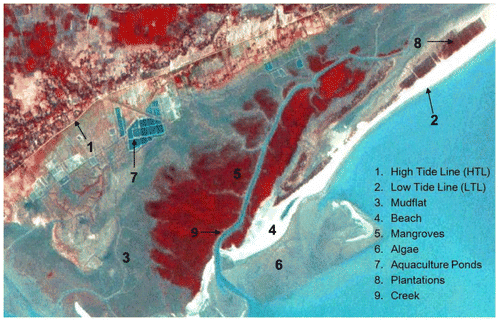
The baseline information on coastal and marine habitats is vital. The first inventory of coastal habitats in India, with emphasis on coral reefs and mangroves, was carried out using IRS LISS II and LANDSAT TM data (1989–1991) at 1:250,000 and 1:50,000 scales (Jagtap, Naik, and Nagle Citation2001; Nayak et al. Citation1991, 1992). These maps show high tide line and low tide line (HTL and LTL) and landform/wet land features such as mudflats, beach, mangroves, coral reefs (as shown in Figure ). Coastal land use maps showing HTL and LTL and land use features were also prepared at a scale of 1:25,000. The details of methodologies have been given by Nayak (Citation1994a, Citation2009). The distinctive patterns of ecological and morphological zones of these two ecosystems were identified using IRS LISS III and Panchromatic (PAN) merged data (Bahuguna and Nayak Citation1998; Nayak et al. Citation1996; Shah et al. Citation2005). All the thematic maps related to coastal land use, wetland, mangroves, coral reefs, and shoreline changes have been organized in a GIS and Query Shell has been developed to create a database and generate output maps (Gupta, Krishnarajan, and Nayak Citation2001; SAC Citation2011). All these maps and outputs can be downloaded from www.vedas.sac.gov.in. The classification accuracy of these maps was 85% at 90% confidence level. In many regions, mangroves and coral reefs have degraded and as well as reclamation of lagoons and mudflats have been observed (Desai et al. Citation1991; Nayak et al., Citation1992).
Figure 1. Various coastal landforms in East Coast of India (IRS LISS III and PAN merged Image of the Subarnrekha Estuary).
Coral reef, a keystone ecosystem of tropical region, is a highly productive area and exhibits distinctive ecological and geomorphological patterns. Such zones were mapped for all coral reef areas of the country. It was possible to identify types of reefs, characteristics of reef flats, lagoon, etc. (Deshmukh et al. Citation2005). Submerged coral reef features were identified using OCEANSAT OCM and RESOURCESAT LISS III data (Chauhan and Nayak Citation2005; Mahendra et al. Citation2010a). The extent of live corals was delineated only in a few cases. This is the limitation of these datasets. Hyperion hyper-spectral data in VNIR region are able to distinguish morphological features such as healthy (live) and degraded corals, reef flat, algal cover, algal ridges, sea grass, lagoon, knolls, and sandy areas (Velloth, Mupparthy, and Nayak Citation2012; Velloth et al. Citation2014). An approach, Coupled Ocean Atmosphere Radiative Transfer (COART) to correct for atmospheric and oceanic effects has been developed and applied to correct Hyperion data (Velloth et al. Citation2014). Fusion of high spatial resolution images from IRS LISS IV, IKONOS, QUICK BIRD, etc. can further improve classification of coral reefs (Velloth, Mupparthy, and Nayak Citation2015).
It was observed that coral reefs are generally in good condition, except those in the Gulf of Kachchh, Western India. This unique system is facing both natural and anthropogenic stress. The high suspended sediment load in the Gulf of Kachchh and anthropogenic activities have adversely affected coral reefs (Bahuguna and Nayak Citation1998; Sharma et al. Citation2008). The tsunami of 2004 destroyed almost 400 km2 of coral reef areas and 130 km2 of reef were covered with backwash in the Andaman and Nicobar Islands (Nayak and Bahuguna Citation2008). However, it was observed that coral reefs have been recovering slowly and showing its resilience capacity (Bahuguna, Nayak, and Roy Citation2008). Mesoscale processes such as cyclonic eddy can affect coral reefs. It is inferred based on model outputs that cyclonic eddy observed in South-west (SW) of Sumatra, though it generally enhances primary productivity, it can significantly damage corals through asphyxiation caused by massive phytoplankton blooms (Reddy et al. Citation2010).
Incidences of coral bleaching have increased during the last two decades, especially in 1998 and 2010, due to warming of the sea. Coral reefs are made of many species of corals, each of which has a symbiotic relationship with algae living in their tissues. These algae supply vital nutrition to the host but are sensitive to environmental changes including increase in seawater temperature. However, we know that in the Persian Gulf, corals withstand high temperature, probably because of high thermal tolerance by algae (Hume et al. Citation2013). In view of increased warming of sea, corals may be quite different in the future (Normile Citation2010). The associated loss of algae is known as coral bleaching. Hence, monitoring the health of order coral reefs is very vital. NOAA AVHRR Sea Surface Temperature (SST) data were used to identify cumulative temperature anomalies and thermal stress over coral reef regions. These two products were used to identify probable areas of bleaching (Mohanty et al. Citation2013). It was observed that soft corals such as Acropora are affected significantly, unlike hard corals such as Porites. Using this concept, Coral Bleaching Alert System (CBAS) has been introduced and regular bulletins are issued for coral reef areas (www.incois.gov.in).
The estimate for mangroves based on satellite data was 4460 km2 (Nayak and Bahuguna Citation2001). The identification of dominant communities, viz. Avicenna, Rhizophora, Ceriops, Heritiera, Excoecaria, Sonneratia, Xylocarpus, etc. was accomplished using a combination of red, infrared, and middle-infrared bands of IRS 1C LISS III data (Nayak et al. Citation1996). The community-wise classification of mangroves for the entire Indian coast was carried out (Ajai et al. Citation2013; SAC Citation2011). The mangrove area along the Indian coast has increased to 4956 km2 (SAC Citation2011). The increase in mangrove extent was observed on the coasts of Maharashtra, Goa, Tamil Nadu, Orissa, and West Bengal, essentially due to conservation measures. The major decrease in mangroves was noticed on the Gujarat coast. In most cases the degradation in mangrove habitat was due to their conversion for agriculture, aquaculture or industrial use. Significant decrease in mangrove areas (150 km2), on the Andaman and Nicobar Islands was due to the damage caused by the tsunami in 2004 (Nayak and Bahuguna Citation2008). Cyclones do damage mangroves and such damage is visible in NDVI images generated from OCEANSAT-1 OCM and IRS WIFs (Nayak, Sarangi, and Rajawat Citation2001). It can also be observed in subsequent NDVI images that mangroves are very resilient and they recover within six months. A model for assessing the health of mangroves has been developed based on canopy cover, floral diversity, fragmentation and hydrological parameters and applied in the selected areas to assess the health of mangroves (SAC Citation2011). This model is yet to be applied for the coastline of the entire country.
The extent and condition of coral reefs and mangroves, mapped by using satellite data, is useful as an input to identify boundaries of the protected areas and biosphere reserves as well as to monitor them to detect changes, if any. About 128 marine protected areas have been identified, and monitored using IRS LISS III and IV data. It is demonstrated that the degradation of mangroves and coral reefs can be halted and the recovery of these ecosystems can take place by suitable conservation measures as observed in marine protected areas in the Gulf of Kachchh (Nayak et al. Citation1989). The sustained conservation measures in the Gulf of Kachchh led to substantial increase in both density and extent of mangroves despite increased industrial activities (SAC Citation2011). However, degradation of these two key ecosystems was observed in many other protected areas.
The degradation of coastal habitats also results in loss of biodiversity. The information on biodiversity is very crucial, and is likely to be affected by anthropogenic activity and impact of global warming of sea. The impact of the loss of marine biodiversity on other processes needs to be understood. The detailed records of marine life and changes need to be meticulously recorded. The Indian Ocean Biogeographic Information System (IndOBIS) and Census of Marine Life programs have been launched to pool all the information, which made it available through a portal and internationally accepted data protocol. At present, IndOBIS has records of over 122,000 species, including new records of several species (www.indobis.org), for the Indian Ocean. The focus is on the understanding of the structure, function and vulnerability of ecosystems. We need to ensure a healthy ocean environment for the sustained benefit of our successive generations. Similar information systems for coastal areas need to be developed.
Brackish water aquaculture is one of major activities along most coastal regions of India. The selection of suitable sites is an important step towards efficient management and reducing environmental impacts. The coastal habitat data created for the entire coast were utilized to select the probable areas. Coastal habitat, drainage, transportation network, salinity, pH and other parameters were used to develop a criteria-based GIS model to prioritize sites (Gupta, Krishnarajan, and Nayak Citation2001).
3. Coastal processes and natural hazards
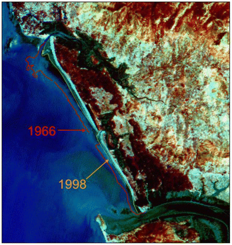
Geomorphic processes of erosion, sediment transport, deposition and sea level changes continuously modify the shoreline. The understanding of coastal processes is vital to plan effective coastal protection measures. It is also vulnerable to various natural hazards such as cyclones, storms, tsunamis which impact the coast. Multi-date high-resolution satellite data were used to detect long-term changes in shoreline and landforms. The information on shoreline changes along with near-shore water flow provide important insight into causes of shoreline changes. The shoreline-change maps using topographical maps (1966–1968) and satellite data of 1985–1989, 1990–1992, and 2004–2006 were prepared (Nayak et al.Citation1992; SAC Citation2011). The areas under erosion, deposition and relatively stable areas were mapped (as shown in Figure ). The construction of breakwaters and jetties for ports have increased erosion, generally in the direction of the long-shore currents as witnessed on the east coast of India (Chauhan et al. Citation1996; Nayak et al. Citation1992, 1997). Similarly, the construction of dams on rivers also introduces erosion, immediately after commissioning of dams (Nayak and Sahai Citation1985). It is observed that the coast stabilizes after few years. The role of sea level changes, neotectonics, and sediment transport was evaluated because they are shaping the present landforms in the Gulf of Khambhat, Western India (Shaikh et al. Citation1989). Shoreline change and landform maps for the coastline of the entire country are now available (www.vedas.sac.gov.in).
Figure 2. Erosion between 1966 and 1998 in IRS LISS III Image of the West Coast of India.
Geomorphic processes of erosion, sediment transport and deposition in the vicinity of river mouths on the West coast of India were studied by using satellite data as well as ground observations and sediment analysis. The sedimentation in the river mouth essentially takes place during pre-monsoon period (April–May), while beaches grow during post-monsoon (October–December) period (Nayak et al. Citation2010). On the same coast, OCEANSAT-1 OCM data showed the northward and southward movement of suspended sediments along the coast during monsoon (June–September) and post-monsoon (October–December) period. The net suspended sediment movement towards estuarine mouths resulted in the formation of mudflats (Nayak et al. Citation2012). In the same region, the presence of all types of spits, viz. paired, single and wing like, suggested that the role of sea level changes and tectonics along with long-shore currents in their formation (Hegde et al. Citation2012). The presence of submerged bars is also very critical in formation of spits. The divergent spits are formed due to reversal in a long-shore drift and wave divergence which favor the movement of sediment in opposite directions (Hegde et al. Citation2015).
An artificial mouth was created on the Chilika lagoon in 2000. Remote sensing data were effectively used to assess the impacts of such an artificial mouth on the Chilika lagoon in the East of India (Rajawat et al. Citation2007). The original 80 m-wide mouth was widened to 680 m over a period of time and erosion of the coast occurred. However, there was an improvement in tidal flux and mixing resulted in increased salinity levels and reduced weeds. This ultimately improved brackish water fishery in the lagoonal area. The repetitive satellite data proved to be quite useful in monitoring the impacts of engineering structures.
The coastal regions are regularly affected by cyclones and storm surges and occasionally by tsunamis. We must live with such hazards, and prepare ourselves to respond to hazards to save lives. It is essential to identify vulnerable areas, so that associated risks can be recognized and necessary mitigation measures can be taken up.
Coastal topography is one of the critical factors in defining vulnerability because its characteristics significantly affects the inundation due to storm surge or tsunami. The accurate information on topography improves the estimation of inundation. The evaluation of elevation data derived from CARTOSAT and Airborne Laser Terrain Mapper (ALTM) was carried out (Nayak et al. Citation2013). It was observed that the elevation accuracies of CARTOSAT and ALTM are ±2 m and ±0.6 m, respectively. This inaccuracy affects the extent of inundation up to a certain extent. Considering the cost and time required for acquiring and analyzing ALTM data, its use may be restricted to urban areas. CARTOSAT data are quite suitable to be used in coastal regions.
Coastal vulnerability maps (cyclone, tsunami, and sea level rise) for the entire Indian coast, based on projected long-term rise in sea level, and climatological data on tidal range and wave height, coastal elevation and slope, long-term shoreline changes (rate of erosion and accretion) along with geomorphological setting have been produced (Kumar et al. Citation2010). The vulnerability has been defined in terms of an index indicating likelihood of physical changes that may occur and the natural ability of coastal system to change environmental conditions. Such maps can provide base level information for coastal management. Vulnerability maps of the entire country have been prepared (www.incois.gov.in). In another project, a slightly different approach was used to prepare the multi-hazard and risk maps for part of the tsunami-affected area on the East coast of India (Mahendra et al. Citation2011, Citation2010b).
Rising sea levels are already eroding shorelines, slowly drowning low-lying areas, and changing shoreline configuration of the coast. These changes in sea level coupled with high tides and waves and storm surges can cause excessive episodic flooding. Such flooding affects the ecosystems, settlements, and port operations, and ultimately the livelihood of coastal communities as well as leads to migration of local people to other areas (Nayak Citation1994b). Human modification of the shoreline has altered currents and sediment delivery, resulting in the advancement of the coast in some areas and eroding beaches in others regions. We know that the evolution of coast depends on regional tectonics, sea level rise, vegetation, and wave activity. One view is that the slow rise in the sea level will advance the coasts while rapid rise will erode them (Stutz and Pilkey Citation2011). Recently, a distinct reversal of the Northern Indian Ocean (North of 5°S) sea-level decadal trend between 1993 and 2013 by using satellite and in situ observations, ocean analysis products and model simulations was reported (Srinivasu et al. Citation2017). We need to model the impact of such changes in sea-level rise on coasts and islands. We should make people aware of the changing environment and take adaptive and mitigation measures. Healthy mangrove and coral reef ecosystems can significantly mitigate the impact of sea-level rise on coastal areas (Baba and Nayak Citation2002).
Cyclones over the oceans trigger strong biological response and induce phytoplankton blooms (Vinay Chandran and Mathew Citation2003). In the Bay of Bengal, cyclones are very frequent and cause lots of damage to infrastructure and life. The super cyclone which occurred during October 1999 in the Bay of Bengal, induced meso-scale phytoplankton bloom as evidenced from satellite data and persisted for over a month (Reddy, Salvekar, and Nayak Citation2008). It was observed that productivity increases substantially along the track of a cyclone. Such blooms were observed during subsequent cyclones as well. However, the magnitude of productivity varies during such events (Lotlikar et al. Citation2014; Masuluri Citation2009). Since phytoplankton plays a very significant role in the global carbon cycle, it is necessary to compute the uptake of carbon dioxide during such blooms.
A tsunami is a system of ocean waves formed as a result of large scale disturbances of the ocean floor. A state-of-the-art tsunami warning system has been designed around GIS and implemented after the devastating tsunami in December 2004 (Nayak and Kumar Citation2008, 2009, 2011). The system is capable of receiving and analyzing seismic and sea level, both on coast and deep sea, received from the Indian and global stations, in real time. It provides advisories about travel time, and run-up-height at 1800 coastal forecast points within 10 min to all concerned within India and the Indian Ocean Rim countries through web-based services. The performance of the tsunami warning system is as per design specifications (Kumar et al. Citation2012a, 2012b). The system has provided very useful advisories during last ten years. It is now recognized as the Regional Tsunami Service Provider for the Indian Ocean.
The prediction of cyclone tracks and landfall, 24 h before the event, has been improved to 140 km and 70 km, respectively (Mohapatra et al. Citation2013, 2015). The assimilation of OSCAT data improved the location of the center and track predictions (Prasad et al. Citation2013). The information on storm surges and associated inundation is very important for disaster management authorities. A simulation of both these aspects was carried out using the ADCIRC model (Kumar et al. Citation2015). The simulated and observed surge heights matched well, but were underestimated. The extent of inundation matched reasonably well but an improved topographic model using CARTOSAT and ALTM data can further enhance the accuracy of delineation of inundation boundaries.
4. Water quality
Many national and regional monitoring programs exist for monitoring a variety of pollutants. In India, coastal water quality is being monitored for last 25 years at 24 priority sites. Various physical, chemical and microbiological parameters (total 54) for water and sediments are measured seasonally. Increased nutrient inputs to coastal waters due to rise in coastal population and agriculture intensification have been observed at many sites. This led to decreased levels of dissolved oxygen in coastal waters, although they are not at the alarming levels. This data helped to take mitigating action wherever pollution levels crossed threshold values. The data is available on www.incois.gov.in/portal/comaps/home.jsp.
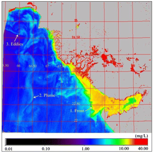
Suspended sediments movement along with shoreline change information helps to understand relationships between sediment input, transport, and deposition (Nayak Citation2009). In tide-dominated areas, such as the Gulf of Khambhat and the Hooghly estuary, tides play very critical role in movements of sediments and fronts (Nayak and Sahai Citation1985; Nayak et al. Citation1996). OCEANSAT-1 Ocean Colour Monitor (OCM) provides extremely useful information on decay of fronts, eddies, gyres, plumes, etc. Due to its high temporal resolution (as shown in Figure ), OCM data were used to compute the advective velocity of surface currents and thus, to understand movement of sediments (Nayak Citation2009; Prasad et al. Citation2002). Such information is very useful in modeling the path of waste effluents.
Figure 3. Suspended concentration in Oceansat-1 OCM Image of the North Coast of India.
The frequency of Harmful Algal Blooms, resulting in mass mortality and morbidity of marine organisms, has increased significantly. In the North Arabian Sea, we have observed the shift from diatom to green dinoflagellates (Gomes et al. Citation2008). The increase in extreme rainfall also increases river run-off, polluting coastal waters with more nitrogen and phosphorus, sediments and other contaminants. Increased direct monitoring of water quality parameters, coupled with satellite data, will improve our knowledge of health of coastal and ocean waters.
5. Living resources
Marine fishery catch in India is about 3.5–4.0 million tonnes. Fishermen used to spend considerable time in locating fish schools and thus, cost-per-unit efforts were high. A satellite-based technique was developed to locate potential fishing grounds using NOAA AVHRR SST (Narain et al. Citation1990). This system was based on the detection of oceanographic features such as upwelling, divergent fronts, eddies, gyres, rings, meanders. Because the temperature variation in tropical waters is only about 3 °C, this technique was not very successful. During late 90s, the availability of satellite-derived chlorophyll information and its integration with SST further improved forecasts (Solanki, Dwivedi, and Nayak Citation1998). A successful GIS-based fishery forecast system was developed by integrating chlorophyll, SST, surface currents and bathymetry (Nayak, Kumar, and Nagarajakumar Citation2007). Daily advisories for more than 350 fishing harbors are being generated and disseminated through electronic boards at fishing harbors, web (www.incois.gov.in), and e-mails. At present, about 93% of fishermen are adopting these advisories, which direct fishermen to the productive areas and hence avoid exploitation of fishery in low to moderately productive areas. This technique helped fishermen to reduce catch-per-unit effort and hence brought economic benefits to fishermen.
Overfishing caused degradation of coastal and marine ecosystems, and destructive trawling techniques led to loss of nursery areas of commercial fishery in some regions. Hence, loss of coastal habitats affected the capacity of producing fish for human consumption. It was also discovered that populations of phytoplankton and copepods are also changing, threatening food supply of fishes as well as many marine mammals that in turn prey on fish (Sanjeevan, Smitha, and Padmakumar Citation2014). Such a shift can transform the biodiversity and functioning of marine ecosystems. There are many examples where changes in ocean climate contribute to shifts in abundances and seasonal cycles of variety of species. The increased availability of Sardines on the East coast and on the Maharashtra coast while reduced supply on the Kerala coast is an example (Sanjeevan, Smitha, and Padmakumar Citation2014). Annual stock assessments of fish are necessary to identify Maximum Sustainable Yield (MSY) for various commercially important species. This assessment will help to manage fishery for sustainable yield.
6. Summary and outlook
Coastal zone management depends on the information available on varied aspects of coastal habitats, coastal processes, natural hazards and their impacts, water quality, and living resources. The effective management practices depend on such knowledge and suitable response by concerned government agencies.
The loss of coastal habitat areas reduces key ecological services. Fish and shell fish stocks may decline and shoreline may be destabilized. The relationship between health of wetlands and fish stocks is generally linear. The ecological services are provided by wetlands, i.e. the wave attenuation service that protects coasts from storms and tsunamis. The relationship between this service and wetland area is non-linear (Barbier et al. Citation2008). Such relationships have consequences for management and should be taken into account. Hence, the optimal land use option should include the integration of development and conservation activities and should be consistent with ecosystem-based coastal zone management goals.
The identification of areas suitable for brackish water aquaculture was accomplished based on coastal landforms and land use derived from satellite images for the coastline of the entire country. The movement of sediments along the coast, onshore–offshore sediment transport, impact of tides on sediment movement, and impact of engineering structures on sediment movement and areas under erosion and deposition, were studied using high temporal resolution satellite data. Based on this information, the alternative methods to restore beach such as beach nourishing and construction of an artificial reef are being attempted.
In order to preserve coastal ecosystems, the Government of India has declared areas between high and low tide lines (HTL, LTL) and 500 m from HTL as the Coastal Regulation Zone (CRZ) and prohibited or restricted construction and industrial activities. The accurate delineation of HTL and LTL is very critical. They have been delineated based on tonal discontinuity on satellite images (Nayak Citation2009). This regulation has undergone too many changes over last 25 years, mainly due to incorrect interpretation of HTL and conflicting laws of state and central governments. In view of this, it was suggested that such anomalies should be removed. CRZ regulation needs to focus on protecting ecologically sensitive areas, while urban and rural areas are governed by existing laws of state and central governments with few conditions (Nayak et al. Citation2015). Local communities may be allowed to take up traditional aquaculture, ornamental fisheries, etc. In a separate report, it was also suggested to draw HTL using ALTM and high-resolution satellite data for the coastline of the entire country and use it as a construction setback line to draw boundaries of CRZ. However, these suggestions are yet to be implemented. Despite these limitations, this regulation has helped to conserve most of the protected areas, ensure livelihood security of fishermen, provide resilience to impacts of hazards and promote socio-economic development based on scientific principles.
The effects of anthropogenic activities on ecosystems have not been well-understood. We need to carry out predictive modeling, using existing climatic, coastal, and topographic data combined with ecological information, where historical data is available. We also know that the current climate impact models have been showing very large uncertainty. We need to improve the understanding of likely impact of anthropogenic activities on the coastal environment.
The advisory services for the cyclone and tsunami have been provided to all stakeholders. The response of the government to such events at the local, state and national levels has been exemplary. In the last century, a super cyclone struck the Orissa coast and more than 10,000 people died. During the last 10 years, loss of lives has been minimized because of the availability of accurate and timely information on track, landfall point, velocity of wind, storm surge, etc. (Mohapatra et al. Citation2013, 2015), the suitable response and actions of the government and the trust of local people in the forecast and government. The tsunami warning center has performed very well (Kumar et al. Citation2012a) and there has been no false warning during the last 10 years. Such systems have definitely helped to reduce risk from these hazards. Though coral reef bleaching alert bulletins have been issued, it is not clear how one can respond to such an event. We need to address the issue of developing a response mechanism.
The sustainable management also depends on the nature of the social system, comprising political economic and industrial infrastructure and its linkages, with the knowledge about coastal systems as well as local communities. We have noted that economic growth and technological advancement during last two centuries have significantly affected our coastal environment and have also become major driver of influencing the earth system. The earth system processes, especially carbon cycle, ocean acidification, sea level changes, loss of biodiversity, and modern agriculture-induced pollution of reactive nitrogen and phosphorous, have reached a level at which they can cause damage to the entire earth system (Rockström et al. Citation2009). We need to model impacts of these processes and design adaptive and mitigation strategies for the sustainable development of the coastal zone. Geospatial information technology can contribute greatly to develop such models.
Notes on contributors
Shailesh Nayak is the distinguished scientist in the Ministry of Earth Sciences (MoES) and the President of the 36th International Geological Congress. He obtained his PhD degree in Geology from the MS University of Baroda in 1980. He was the Secretary of MoES, Government of India, during August 2008–2015, and provided leadership for programs related to earth system sciences. He set up the state-of-the-art tsunami warning system for the Indian Ocean in 2007, and provided tsunami advisories to the Indian Ocean rim countries. He has pioneered the development of algorithms and methodologies for the application of remote sensing to the coastal and marine environment, generated the baseline database of the Indian coast, and developed services for fishery and ocean state forecast. This coastal database has formed the basis of managing the coasts in India. He is fellow of the Indian Academy of Sciences, and the National Academy of Sciences, India, fellow of the International Society of Photogrammetry & Remote Sensing (ISPRS) and elected member of the International Academy of Astronautics (IAA). He was conferred the prestigious ISC Vikram Sarabhai Memorial Award 2012, as well as Bhaskara Award 2009, for his outstanding contributions in remote sensing and GIS. He has published about 150 papers in peer-reviewed journals.
Acknowledgments
The author is extremely grateful to Dr. M. Rajeevan, Secretary, Ministry of Earth Sciences (MoES), Government of India, and Dr. A. S. Kiran Kumar, Chairman, Indian Space Research Organization (ISRO) and Secretary, Department of Space, Government of India, for encouragement and useful suggestions. My deep sense of gratitude are to Dr. Tapan Mishra, Director, Space Applications Centre, ISRO and Dr. Satheesh Shenoi, Director, ESSO – Indian National Centre for Ocean Information Services (INCOIS), for their keen interest in this study. My colleagues, both at ISRO and ESSO-MoES, deserved special thanks for their support and discussions.
References
- Ajai, A. B., H. B. Chauhan, K. Sen Sarma, S. Bhattacharya, S. Ashutosh, C. N. Pandey, T. Thangaradjou, L. Gnanppazham, V. Selvam, and S. R. Nayak. 2013. “Mangrove Inventory of India at Community Level.” National Academy Science Letters 36 (1): 67–77.10.1007/s40009-012-0087-x
- Baba, M., and S. Nayak. 2002. “Chapter Fifteen, Muddy Coasts of India.” Proceedings in Marine Science 4: 375–390.10.1016/S1568-2692(02)80089-4
- Bahuguna, A., and S. Nayak. 1998. Coral Reefs of Indian Coast, 54. (Scientific Note) SAC/RSA/RSAG/DOD-COS/SN/16/98. Ahmedabad: Space Applications Centre.
- Bahuguna, A., S. Nayak, and D. Roy. 2008. “Impact of the Tsunami and Earthquake of 26th December 2004 on the Vital Coastal Ecosystems of the Andaman and Nicobar Islands Assessed Using RESOURCESAT AWiFS Data.” International Journal of Applied Earth Observation and Geoinformation 10 (2): 229–237.10.1016/j.jag.2008.02.010
- Barbier, E. B., E. W. Koch, B. R. Silliman, S. D. Hacker, E. Wolanski, J. Primavera, et al. 2008. “Coastal Ecosystem-based Management with Non-linear Ecological Functions and Values.” Science 319 (5861): 321–323.10.1126/science.1150349
- Chauhan, P., and S. Nayak. 2005. “Detection of Submerged Reef Banks in the Lakshadweep Sea Using IRS P-4 OCM Satellite Data.” Current Science 89 (3): 537–560.
- Chauhan, P., S. Nayak, R. Ramesh, R. Krishnamoorthy, and S. Ramachandran. 1996. “Remote Sensing of Suspended Sediments Along the Tamil Nadu Coastal Waters.” Journal of the Indian Society of Remote Sensing 24 (3): 105–114.10.1007/BF03016123
- Desai, P. S., A. Narain, S. R. Nayak, B. Manikiam, S. Adiga, and A. N. Nath. 1991. “IRS-1A Applications for Coastal and Marine Resources.” Current Science 61 (3&4): 204–208.
- Deshmukh, B., A. Bahuguna, S. Nayak, V. K. Dhargalkar, and T. G. Jagtap. 2005. “Eco-Geomorphological zonation of The Bangaram Reef, Lakshadweep.” Journal of the Indian Society of Remote Sensing 33 (1): 99–106.10.1007/BF02989997
- Gomes, H. D. R., J. I. Goes, S. G. P. Matondkar, S. G. Parab, A. R. N. Al-Azri, and P. G. Thoppil. 2008. “Blooms of Noctiluca miliaris in the Arabian Sea – An in situ and satellite study.” Deep Sea Research Part I: Oceanographic Research Papers 55 (6): 751–765.10.1016/j.dsr.2008.03.003
- Gupta, M. C., V. P. Krishnarajan, and S. Nayak. 2001. “Brackish Water Aquaculture Site Selection in Coastal Track of Cannanore (Kerala) using Remote Sensing and GIS Techniques.” Journal of the Indian Society of Remote Sensing 29 (1–2): 79–83.10.1007/BF02989917
- Hegde, V. S., S. R. Nayak, G. Shalini, P. A. Krishnaprasad, A. S. Rajawat, K. H. Girish, and B. Tejaswini. 2012. “Spit Dynamics Along the Central West Coast of India: Implications for Coastal Zone Management.” Journal of Coastal Research 28 (2): 505–510.
- Hegde, V. S., S. R. Nayak, P. A. Krishnaprasad, A. S. Rajawat, R. Shalini, and S. Jayakumar. 2015. “Evolution of Diverging Spits across the Tropical River Mouths, Central West Coast of India.” Journal of Coastal Zone Management 18: 402–405. http://dx.doi/10.4172/jczm.1000402.
- Hume, B., C. D’Angelo, J. Burt, A. C. Baker, B. Riegl, and J. Wiedenmann. 2013. “Corals from the Persian Gulf/Arabian Gulf as Models for Thermotolerant Reef Builders: Prevalence of Clade C3 Symbiodinium, Hose Fluorescence and Ex Situ, Temperature Tolerance.” Marine Pollution Bulletin 72 (2): 313–322.10.1016/j.marpolbul.2012.11.032
- Jagtap, T. G., S. Naik, and V. L. Nagle. 2001. “Assessment of Coastal Wetland Resources of CentralWest Coast, India, Using Landsat Data.” Journal of the Indian Society of Remote Sensing 29 (3): 143–150.10.1007/BF02989926
- Kumar, T. S., R. S. Mahendra, S. Nayak, K. Radhakrishnan, and K. C. Sahu. 2010. “Coastal Vulnerability Assessment for Orissa Coast, East Coast of India.” Journal of Coastal Research 26 (3): 523–534.10.2112/09-1186.1
- Kumar, T. S., S. Nayak, P. Kumar, R. B. S. Yadav, B. A. Kumar, M. V. Sunanda, E. U. Devi, N. K. Kumar, S. A. Kishore, and S. S. C. Shenoi. 2012a. “Successful Monitoring of 11 April 2012 Tsunami off the Coast of Sumatra by Indian Tsunami Early Warning Centre.” Current Science 102 (11): 1519–1526.
- Kumar, T. S., S. Nayak, P. Kumar, R. B. S. Yadav, A. Kumar, M. V. Sunanda, E. U. Devi, and S. S. C. Shenoi. 2012b. “Performance of the Tsunami Forecast System for the Indian Ocean.” Current Science 102 (1): 110–114.
- Kumar, T. S., P. L. N. Murthy, M. P. Kumar, M. K. Kumar, J. Padmanabham, N. K. Kumar, S. C. Shenoi, M. Mohapatra, S. Nayak, and P. Mohanty. 2015. “Modeling Storm Surge and its Associated Inland Inundation Extent Due to Very Severe Cyclonic Storm Phailin.” Marine Geodesy 38 (4): 345–360.10.1080/01490419.2015.1053640
- Lotlikar, A. A., T. S. Kumar, V. S. Reddem, and S. Nayak. 2014. “Cyclone Phailin Enhanced theProductivity Following its Passage: Evidence from Satellite Data.” Current Science 106 (3): 360–361.
- Mahendra, R. S., S. Bisoyi, P. C. Mohanty, S. Velloth, T. S. Kumar, and S. Nayak. 2010a. “Applications of the Multi-spectral Satellite Data from IRS-P6 LISS III and IRS-P4 OCM to Decipher Submerged Coral Beds Around Andaman Islands.” International Journal of Earth Sciences and Engineering 3 (5): 626–631.
- Mahendra, R. S., P. C. Mohanty, T. S. Kumar, S. S. C. Shenoi, and S. Nayak. 2010b. “Coastal Multi-hazard Vulnerability Mapping: A Case Study along the Coast of Nellore District, East Coast of India.” European Journal of Remote Sensing 42 (3): 67–76.
- Mahendra, R. S., P. C. Mohanty, H. Bisoyi, T. S. Kumar, and S. Nayak. 2011. “Assessment and Management of Coastal Multi-hazard Vulnerability Along the Cuddalore–Villupuram, East Coast of India Using Geospatial Techniques.” Ocean and Coastal Management 54 (4): 302–311.10.1016/j.ocecoaman.2010.12.008
- Masuluri, N. K. 2009. “Phytoplankton bloom due to cyclone sidr in the central bay of bengal.” Journal of Applied Remote Sensing 3 (314): 419–420.
- Mohanty, P. C., H. Bisoyi, T. S. Kumar, G. Grinson, S. Nayak, and B. K. Saha. 2013. “Assessment of the Coral Bleaching during 2005 to Decipher the Thermal Stress in the Coral Environs of the Andaman Islands using Remote Sensing.” European Journal of Remote Sensing 46 (4): 417–430.10.5721/EuJRS20134624
- Mohapatra, M., D. P. Nayak, M. Sharma, R. P. Sharma, and B. K. Bandopadhyay. 2013. “Evaluation of Official Tropical Cyclone Track Forecast Over North Indian Ocean Issued by India Meteorological Department.” Journal of Earth System Science 122 (3): 589–601.10.1007/s12040-013-0291-1
- Mohapatra, M., D. P. Nayak, M. Sharma, R. P. Sharma, and B. K. Bandopadhyay. 2015. “Evaluation of Official Cyclone Landfall Forecast Issued by India Meteorological Department.” Journal of Earth System Science 124 (4): 861–874.10.1007/s12040-015-0581-x
- Narain, A., R. M. Dwivedi, H. U. Solanki, B. Kumari, N. Chaturvedi, P. S. B. R. James, G. Subba Raju, D. Sudarsan, and T. E. Sivaprakasam. 1990. “The Use of NOAA-AVHRR Data in Fisheries Exploration in the Indian EEZ.” In the Proceedings of the Seminar on Remote Sensing for Marine Fisheries Studies, Beijing, China. ESCAP/UNDP (ras/86/141), 226–232.
- Nayak, S. 1994a. “Application of Remote Sensing in Studying Mangrove Ecosystems.” In Conservation of Mangrove Genetic Resources − A Training Manual, edited by Sanjay Deshmukh and V. Balaji, 203–220. Madras: M. S. Swaminathan Research Foundation, India; Yokohama: International Tropical Timber Organisation, Japan.
- Nayak, S. 1994b. “Application of Remote Sensing Data for Estimation of Impact of Sea Level Rise Along the Gujarat Coast.” In Global Change Studies. Scientific Results from ISRO Geoshere Biosphere Programme, 337–348. ISRO-GBP-SR-42-94. Bangalore: Indian Space Research Organisation.
- Nayak, S. 2009. “Application of Remote Sensing and GIS for Coastal Zone Management.” In the Manual of Geographic Information Systems, edited by M. Madden, 1075–1093. Bethesda, MD: The American Society for Photogrammetry and Remote Sensing.
- Nayak, S., and A. Bahuguna. 2001. “Application of Remote Sensing Data to Monitor Mangroves and Other Coastal Vegetation of India.” Indian Journal of Marine Sciences 30 (4): 195–213.
- Nayak, S., and A. Bahuguna. 2008. “Application of Remote Sensing for Damage Assessment of Coastal Ecosystems in India Due to December 2004 Tsunami.” In Remote Sensing and GIS Technologies for Monitoring and Prediction of Disasters, edited by S. Nayak and S. Zlatanova, 37–56. Berlin Heidelberg: Springer.10.1007/978-3-540-79259-8
- Nayak, S., and T. S. Kumar. 2008. “Addressing Risk of Tsunami in the Indian Ocean.” Journal of South Asia Disaster Studies 1 (1): 45–47.
- Nayak, S., and T. S. Kumar. 2009. “The First Tsunami Early Warning Centre in the Indian Ocean.” In Risk Wise, 175–177. UK: Tudor Rose.
- Nayak, S., and T. S. Kumar. 2011. “Tsunami Watch and Warning Centres.” In Encyclopedia of Solid Earth Geophysics, edited by H. K. Gupta, 2, 1498–1505. Dordrecht: Springer Netherlands.
- Nayak, S. R., and B. Sahai. 1985. “Coastal Morphology: A Case Study in the Gulf of Khambhat (Cambay).” International Journal of Remote Sensing 6 (3–4): 559–567.10.1080/01431168508948478
- Nayak, S., A. Pamdeya, M. C. Gupta, C. R. Trivedi, K. N. Prasad, and S. A. Kadri. 1989. “Application of Satellite Data for Monitoring Degradation of Tidal Wetlands of the Gulf of Kachchh, Western India.” Acta Astronautica 20 (89): 171–178.10.1016/0094-5765(89)90066-0
- Nayak, S., A. Bahuguna, M. Shaikh, R. S. Rao, C. R. Trivedi, K. N. Prasad, S. A. Kadri, et al. 1991. Manual for Mapping of Coastal Wetlands/landforms and Shoreline Changes Using Satellite Data, 63. Technical Note. IRS-UP/SAC/MCE//SN/32/91. Ahmedabad, India: Space Applications Centre.
- Nayak, S., A. Bahuguna, M. Shaikh, H. B. Chauhan, R. S. Rao, A. Arya, J. P. Aggarwal, et al. 1992. Coastal Environment, 114. Scientific Note RSAM/SAC/COM/SN/11/92. Ahmedabad: Space Applications Centre.
- Nayak, S., P. Chauhan, A. Bahuguna, and A. N. Nath. 1996. “IRS-1C Applications for Coastal Zone Management.” Current Science 70 (7): 614–618.
- Nayak, S., A. Bahuguna, P. Chauhan, H. A. Chauhan, and R. S. Rao. 1997. “Remote sensing Applications for Coastal Environmental Management in India.” MAEER’s MIT Pune Journal, Special Issue on Coastal Environmental Management 4 (15&16): 113–125.
- Nayak, S., R. K. Sarangi, and A. S. Rajawat. 2001. “Application of IRS-P4 OCM Data to Study the Impact of Cyclone on Coastal Environment of Orissa.” Current Science 80 (9): 1208–1213.
- Nayak, S., T. S. Kumar, and M. Nagarajakumar. 2007. “Satellite-based Fishery service in India.” In Full Picture, 256–257. Geneva: Group on Earth Observation (GEO), Tudor Rose.
- Nayak, S. R., V. S. Hegde, G. Shalini, A. S. Rajawat, K. H. Girish, S. Jayakumar, and A. Suryanarayana. 2010. “Geomorphic Processes in the Vicinity of the Venkatapur River Mouth, Central West Coast of India: Implications for Estuarine Sedimentation.” Journal of Coastal Research 265 (5): 925–934.10.2112/JCOASTRES-D-09-00021.1
- Nayak, S. R., V. S. Hegde, R. Shalini, A. S. Rajawat, M. Ali, B. Venkateshwarlu, and I. V. Ramana. 2012. “Application of Satellite Remote Sensing for Investigation of Sediment Dispersion Pattern in the Near Shore Region: A Case Study from the Central West Coast of India.” Journal of Coastal Research 28 (2): 399–406.10.2112/JCOASTRES-D-10-00190.1
- Nayak, S., T. Usha, R. S. Kankara, and N. T. Reddy. 2013. “Tsunami Inundation Modeling and Mapping Using ALTM- and CARTOSAT- Derived Coastal Topographic Data.” Marine Geodesy 35 (4): 429–440.
- Nayak, S., S. Shekhar, R. Ramesh, M. Baba, H. Shah, and A. Senthilvel. 2015. “Report of the Committee to Review the Issues Relating to the Coastal Regulation Zone Notification 2011.” http://www.moef.gov.in.
- Normile, D. 2010. “Hard Summer for Corals Kindles Fears for Survival of Reefs.” Science 329 (5995): 1001–1001.10.1126/science.329.5995.1001
- Prasad, J. S., A. S. Rajawat, Y. Pradhan, O. S. Chauhan, and S. Nayak. 2002. “Retrieval of Sea Surface Velocities Using Sequential Ocean Colour Monitor (OCM) Data.” Journal of Earth System Science 111 (3): 189–195.10.1007/BF02701965
- Prasad, V. S., A. Gupta, E. N. Rajagopal, and S. Basu. 2013. “Impact of Oscat Surface Wind Data on T574l64 Assimilation and Forecasting System – A Study Involving Tropical Cyclone Thane.” Current Science 104 (5): 627–631.
- Rajawat, A. S., M. Gupta, B. C. Acharya, and S. Nayak. 2007. “Impact of New Mouth Opening on Morphology and Water Quality of the Chilika Lagoon – A Study Based on Resourcesat‐1 LISS‐III and AWiFS and IRS‐1D LISS‐III Data.” International Journal of Remote Sensing 28 (5): 905–923.10.1080/01431160600904949
- Reddy, P. R. C., P. S. Salvekar, and S. Nayak. 2008. “Super Cyclone Induces a Mesoscale Phytoplankton Bloom in the Bay of Bengal.” IEEE Geoscience and Remote Sensing Letters 5 (4): 588–592.10.1109/LGRS.2008.2000650
- Reddy, P. R. C., P. S. Salvekar, B. K. Saha, S. Nayak, and T. S. Kumar. 2010. “Role of Cyclonic Eddy in the 7000-year-old Mentawati Coral Reef Death During the 1997 Indian Ocean Dipole Event.” IEEE Geoscience and Remote Sensing Letters 7 (2): 296–300.
- Rockström, J., W. Steffen, K. Noone, Åsa Persson, F. S. Chapin III, E. F. Lambin, T. M. Lenton, et al. 2009. “A Safe Operating Space for Humanity.” Nature 461 (7263): 472–475.10.1038/461472a
- SAC. 2011. Coastal Zones of India, 597. Ahmedabad: Space Applications Centre (ISRO). http://www.sac.gov.in.
- Sanjeevan, V. N., B. R. Smitha, and K. B. Padmakumar. 2014. “Climate Change and Ecosystem Plasticity with Special Reference to Eastern Arabian Sea.” In The Proceedings of the National Seminar on Climate and Marine Ecosystems, Kochi, 1–23, ( CCME-2014), ISBN No. 978-81-922264-1-5.
- Shah, D. G., A. Bahuguna, B. Deshmukh, S. R. Nayak, H. S. Singh, and B. H. Patel. 2005. “Zoning and Monitoring Dominant Mangrove Communities of a Part of The Marine National Park, Gulf of Kachchh.” Journal of the Indian Society of Remote Sensing 33 (1): 155–163.10.1007/BF02990005
- Shaikh, M. G., S. R. Nayak, P. N. Shah, and B. B. Jambusaria. 1989. “Coastal Landform Mapping Around the Gulf of Khambhat Using Landsat TM data.” Journal of the Indian Society of Remote Sensing 17 (1): 41–48.10.1007/BF02995964
- Sharma, S., A. Bahuguna, N. R. Chaudhary, S. Nayak, S. Chavan, and C. N. Pandey. 2008. “Status and Monitoring the Health of Coral Reef Using Multi-temporal Remote Sensing − A Case Study of Pirotan Coral Reef Island, Marine National Park, Gulf of Kachchh, Gujarat, India.” In Proceeding of the 11th International Coral Reef Symp. Ft. Lauderdale, FL.
- Solanki, H. U., R. M. Dwivedi, and S. Nayak. 1998. “Relationship Between IRS MOS-B Derived Chlorophyll and NOAA AVRR SST: A Case Study in the NW Arabian Sea, India.” In Proceedings of the 2nd International Workshop on MOS-IRS and Ocean Colour, 438–442. Berlin: Institute of Space Technology.
- Srinivasu, U., M. Ravichandran, W. Han, S. Sivareddy, H. Rahman, Y. Li, and S. Nayak. 2017. “Causes for the Reversal of North Indian Decadal Sea Level Trend in Recent Two Decades.” Climate Dynamics: 1–18. (online published). doi:10.1007/500382-017-3551-Y.
- Stutz, M. L., and O. H. Pilkey. 2011. “Open-ocean Barrier Islands: Global Influence of Climatic, Oceanographic, and Depositional Settings.” Journal of Coastal Research 272 (2): 207–222.10.2112/09-1190.1
- Velloth, S., R. S. Mupparthy, and S. Nayak. 2012. “Analysis of EO-1 Hyperion over Agatti and Boat Islands.” Proceeding of the 12th International Coral Reef Symposium, Cairns, Australia.
- Velloth, S., R. S. Mupparthy, B. R. Raghavan, and S. Nayak. 2014. “Coupled Correction and Classification of Hyperspectral Imagery for Mapping Coral Reefs of Agatti and Flat Islands, India.” International Journal of Remote Sensing 35 (14): 5544–5561.10.1080/01431161.2014.926410
- Velloth, S., R. S. Mupparthy, and S. Nayak. 2015. Hyperspectral Remote Sensing of Coral Reefs, 165. Saarbrücken: Lambert Academic Publishing.
- Vinay Chandran, P. N., and S. Mathew. 2003. “Phytoplankton Bloom in the Bay of Bengal during the Northeast Monsson and its Intensification by Cyclones.” Geophysical Research Letters 30 (11): doi:10.1029/2002GL016717.